Article

Agroecology for the City—Spatialising ES-Based Design in Peri-Urban Contexts

by
Richard Morris
1,
Shannon Davis
2,
Gwen-Aëlle Grelet
3 and
Pablo Gregorini
1,*
1
Department of Agricultural Science, Faculty of Agriculture and Life Sciences, Lincoln University, Lincoln 7647, New Zealand
2
School of Landscape Architecture, Lincoln University, Lincoln 7647, New Zealand
3
Manaaki Whenua—Landcare Research, Lincoln 7640, New Zealand
*
Author to whom correspondence should be addressed.
Land 2024, 13(10), 1589; https://doi.org/10.3390/land13101589
Submission received: 4 September 2024 / Revised: 27 September 2024 / Accepted: 29 September 2024 / Published: 30 September 2024
(This article belongs to the Special Issue Urban Ecosystem Services: 5th Edition)

Abstract

:
The design of urban systems that allow growth while also maximising ecosystem services is identified as an important priority for creating a Good Anthropocene. An ecosystem service (ES)-based approach to landscape interventions maximises the provision of ESs, and in doing so, repairs and reinforces threatened ecological planetary boundaries. As an urbanising planet, cities are critical frontiers of human interaction with these planetary boundaries, and therefore a critical arena for ES-based intervention. Globally, the predominant pattern of urbanisation is dedensification, an outwardly expanding trend where cities are growing in physical extent at a higher rate than their population growth. We therefore require spatially explicit tools capable of reconciling dedensification and Good Anthropocene visions. We propose a methodology that integrates agroecology and urbanisation and is focussed specifically on the supply of targeted regulating ESs. This ‘Agroecology for the City’ differs from conventional urban agriculture discourse and its preoccupation with food security. Our research interest is agroecological farm systems’ (AFSs) capacity to provide critical life support services in a spatially effective manner to urban systems. Our recent research introduced a new GIS-based model (ESMAX) and a spatial agroecology approach that identified AFS configurations at a 1 ha scale which maximised the supply of three regulating ESs, as well as multifunctional performance across all three ESs combined. In the present research, we apply this process at a larger scale, with 1 ha and 4 ha AFS parcels being integrated with a real-world 200 ha peri-urban residential development. The AFS parcels and built-up areas are configured differently to maximise the supply of ESs identified as critical by the local community. We found that arrangements with AFS parcels interspersed evenly with built-up areas provided the best multifunctionality across the four ESs tested. This supports pathways for a Good Anthropocene that work with the global urbanising reality of dedensification and underpin the need for a hybrid science of rural/urban systems.

1. Introduction

The design of urban systems that allow growth while also maximising ecosystem services is identified as an important priority in the Anthropocene [1,2]. The Anthropocene has been adopted widely to describe, examine and understand the transformed conditions in which humans now live—resulting from an ongoing ‘rupture in Earth history arising from the impact of human activity on the earth system as a whole’ [3,4]. Humanity has the option of following business-as-usual patterns of nature exploitation, which by default will lead to ‘Bad Anthropocene’ outcomes, or to purposefully re-design human-nature interactions (such as urban systems) to create a ‘Good Anthropocene’ [5]. A Good Anthropocene envisages a prosperous, fair and ecologically self-regulating world, presenting an alternative to our present trajectory that places pressure on and transgresses several planetary ecological boundaries [6,7]. Re-design for a Good Anthropocene refers to making deep, structural changes that are based on a comprehension of integrated human–natural systems—the time for making incremental improvements in carbon emissions or substituting components of the outdated system with technical enhancements has long passed [8]. An ecosystem services (ES)-based paradigm is proposed in this research as a suitably transformative re-design framework, where the guiding objective of spatial interventions is to maximise the provision of crucial regulating ESs, and in doing so, repair and reinforce planetary boundaries. These planetary boundaries refer not just to evident climatic changes, but also include atmospheric degradation, ocean acidification, changes in biochemical cycles, freshwater depletion, and unsustainable land-use changes and the loss of biosphere integrity (the latter placing the significance of biodiversity in context) [9,10]. As we now exist on an urbanising planet, cities are critical frontiers of human interaction with these planetary boundaries, and therefore a critical arena for ES-based interventions targeting a Good Anthropocene [2,11].
Globally, the predominant pattern of urbanisation is dedensification, an outwardly expanding trend where cities are growing in physical extent at a higher rate than their population growth [12,13]. This pattern threatens the sources of critical life-supporting regulating ESs that are situated in areas consumed by urban expansion [14]—a reminder that the long-term sustainability of any urban system is inextricably connected to the design of its ES-supplying periphery [15]. By ‘regulating ESs’, we refer to the pervasive yet invisible stocks and flows of nature essential to modern cities. These include local climate and air quality regulation, carbon sequestration and storage, moderation of extreme weather events, waste-water treatment, erosion prevention and maintenance of soil fertility, pollination and biological controls [16,17]. ‘Ecology for the City’ is a current paradigm of Ecological Urbanist thought that promotes a ‘design–ecology nexus’, in which cities are designed to mimic the stocks and flows of self-regulating natural ecosystems, resulting in significant positive outcomes for both the biosphere and for human well-being [18,19]. Importantly, examples of the design–ecology nexus imagined by Ecology for the City include Good Anthropocene visions which embrace dedensification as the prevalent global urban spatial phenomenon which must be co-opted and designed with, rather than controlled and contained [20,21]. These visions engage the reality of a spatially and temporally dynamic urban–rural continuum, in contrast with outmoded, 20th-century design and development approaches such as the Compact City and the Garden City, which have sought with various degrees of success to define and control urban expansion into the ES-providing rural periphery [21,22].
‘Agroecology for the City’ is presented in this work as a spatially explicit methodology capable of utilising the reality of urban dedensification to provide critical regulating ESs. In this respect, Agroecology for the City should be differentiated from conventional concepts of urban agriculture. That area of discourse focuses on food security and related social outcomes, while this work asks the reader to suspend the default association of agricultural systems with food production [23]. Instead, our research interest is in the spatially effective capacity of agroecological farm systems (AFS) situated within the urban fabric to provide critical regulating ESs to cities. Regulating ESs, as well as being an indispensable component of all functioning human–natural systems, underpins the production of more readily recognised and monetised ‘provisioning ESs’ (food, fibre, medicines, etc.) and ‘cultural ESs’ (in which nature enhances people’s intellectual, spiritual or recreational experiences) [24,25,26]. This leveraging capacity is central to the emphasis placed on regulating ESs in developing an ES-based design paradigm. Our focus in this work is therefore on biophysical aspects of AFS—while recognising there are social and political dimensions to agroecology, they are outside the immediate objectives of this work.
This work expands upon our previous exposition of spatial agroecology, in which we applied a new Geographic Information Systems (GIS)-based conceptual model, ESMAX, to quantify and visualise the supply of individual regulating ESs from various configurations of agroecological components set within 1 ha AFS parcels [27]. In this case, the components were clumps of trees arranged on farmland, but components could extend also to pasture and crop configurations, various types of water bodies, and manmade infrastructural elements (buildings, roads, etc.) [28]. Three general types of tree configuration—clump, hedgerow and interspersed—were used in the previous work and are redeployed here. As well as the supply of individual ESs, ESMAX was used to identify multifunctional configurations that provide a good level of performance across the three ESs studied. Multifunctionality is a key characteristic distinguishing spatially and temporally diverse AFS from typical modern industrial farm systems that are typically focused on the provision of a single ES (namely, commodity supply) [29,30]. Whereas industrial systems are characterised by monotonous and simplified production landscapes, AFSs are characterised by heterogeneous arrangements of agroecological components—components, which in the context of designing systems for ES production, we refer to as service-providing units (SPUs) [31]. In our previous work, it was demonstrated that the arrangement of SPUs influences the level of respective ESs produced by that 1 ha AFS parcel. In the present research, we apply this process at a larger scale, with discrete, modular 1 ha and 4 ha AFS parcels being integrated with built-up areas representative of a real-world 190 ha peri-urban residential development. The multifunctional capacity of AFS is exploited in this urban context to maximise the supply of four regulating ESs identified as critical by the local community. The use of agroecological parcels to provide regulating ESs to local urban systems has been demonstrated in recent research [32,33]. This work makes the additional contribution of (1) introducing a spatially explicit methodology for providing targeted regulating ESs at the peri-urban scale, and (2) highlighting a new Anthropocene role for agroecological systems, as a mechanism for spatially effective ES provision within the urban–rural continuum.

2. Method

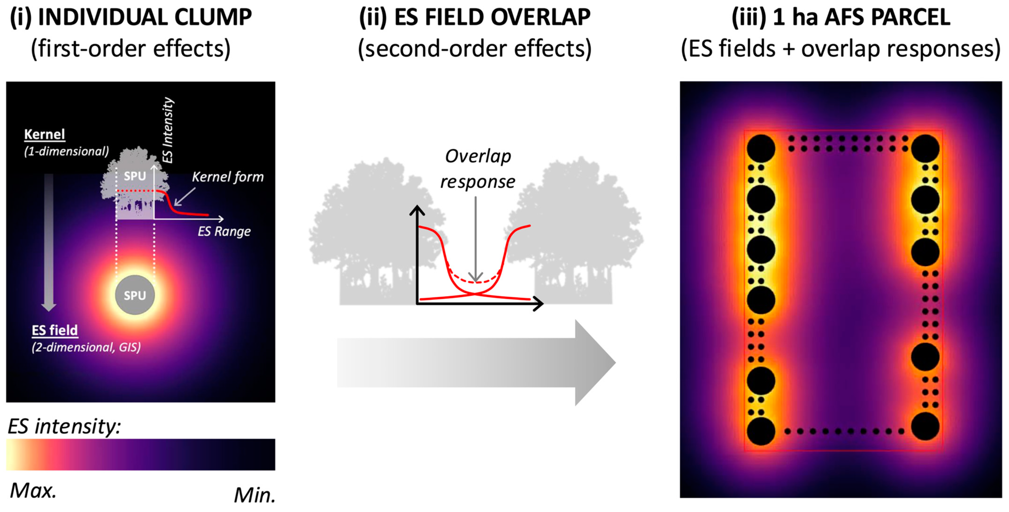
2.1. Description of ESMAX

ESMAX is a GIS-based tool which employs spatial analysis to quantify and visualise ESs supplied by existing or hypothetical arrangements of SPUs. It runs on ArcGIS Pro version 3.0.1 (Esri, Redlands, CA, USA). ESMAX uses plans drawn in GIS to represent spatial configurations of SPUs (in this case, circular clumps of trees of various sizes) distributed across a research area defined with a clear boundary. The tool quantifies and visualises the distance–decay fields (referred to as ‘ES fields’) that describe the influence of the ES over distance from its source SPU. This immediate spatial influence of the SPU is termed a 1st-order effect. ES fields exhibit differences in intensity, decay and range that are characteristic of each type of regulating ES (Figure 1i). Crucially for distinguishing performance between different configurations, this includes the response in ES production where ES fields from neighbouring SPUs overlap (Figure 1ii). The resulting impact on individual ES fields by other ES fields (or other external influences) is termed a 2nd-order effect. This underpins a key distinction between ESMAX and other ES assessment tools. Existing tools, such as InVEST (Integrated Valuation of Ecosystem Services and Trade-Offs [34]), ARIES (ARtificial Intelligence for Environment and Sustainability [35]) and LUCI (Land Utilisation and Capability Indicator [36]) calculate ES performance associated with various land cover types, irrespective of the way these land covers are spatially distributed across the landscape [37,38]. With ESMAX, every point (or pixel) within the defined research area accrues a value resulting from overlapping 1st- and 2nd-order effects. ESMAX displays each research area configuration as a raster (or pixelated) map, visualising the ES fields generated for every SPU (Figure 1iii). It then tabulates the total value of all pixels located within the research area; this total sum being normalised to provide the ‘ES Score’ for that particular configuration for that particular ES. For a detailed description of ESMAX refer to Morris et al., 2024 [38].

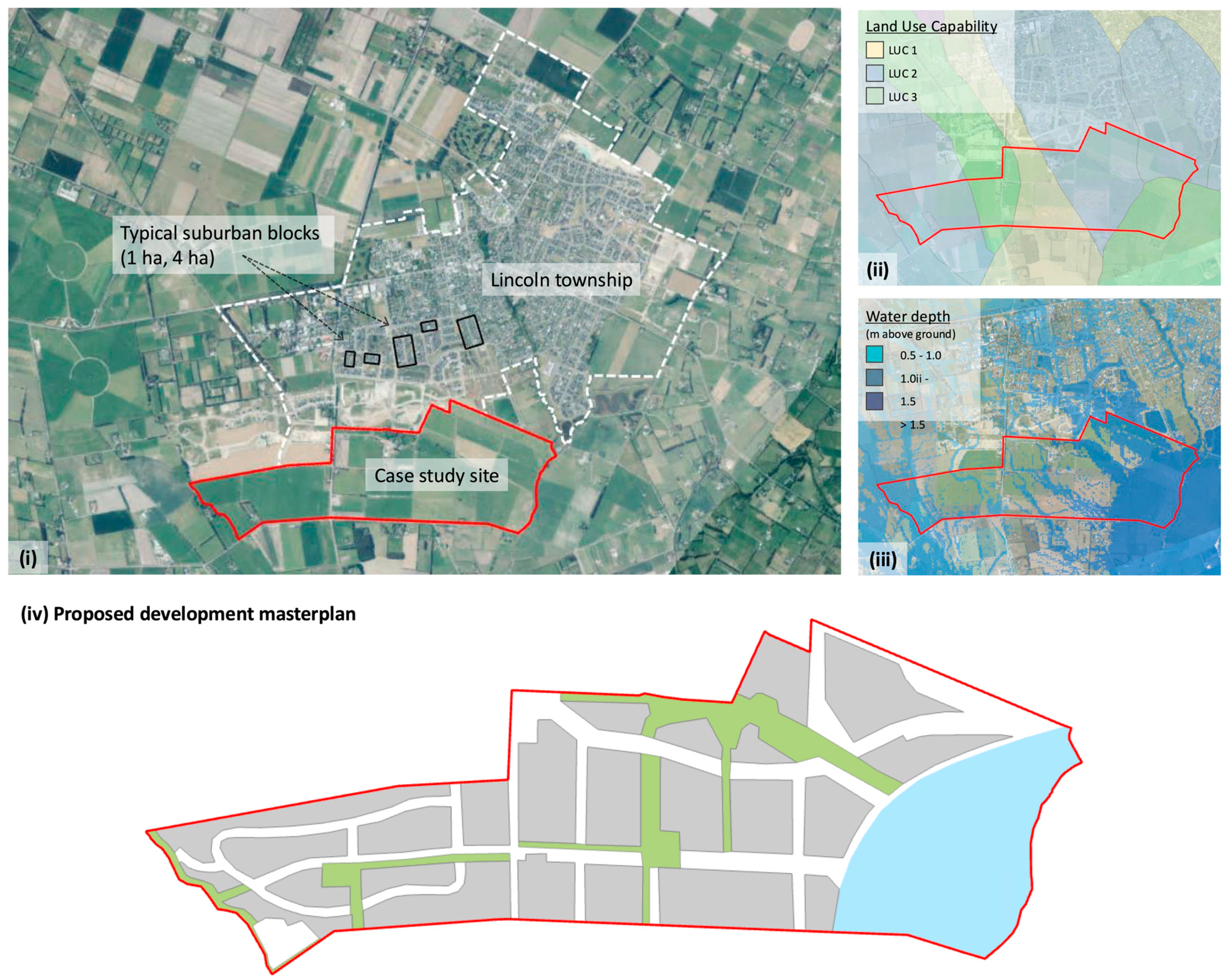
2.2. New Zealand Case Study

The case study used in this research comprises 190 ha of flat, peri-urban farmland located south of Lincoln township in New Zealand’s South Island (Figure 2). To test ESMAX, various arrangements of modular 4 ha and 1 ha AFS parcels are integrated with built-up areas across the development site. The parcel sizes are considered reasonable base modules for the purpose of this research, based on observations and anecdotal data on local agricultural field sizes. Additionally, the SPU sizes resemble the dimensions of the existing suburban blocks of the township the development borders, potentially supporting the spatial integration of agroecological parcels into the accepted local suburban spatial typology (Figure 2i). The expansion of urban areas onto valuable agricultural land in New Zealand serves as a local illustration of the global peri-urban continuum phenomenon. Between 2002 and 2019, urban land use on agricultural land in New Zealand increased by nearly a third, and the area of residential land outside nominal city boundaries more than doubled [39,40]. The scale of the peri-urban continuum for this research is determined by our research interest in the particular regulating ESs supplied by this site to the 700 ha township. Beyond this focal scale, Lincoln also theoretically lies within the 140,000 ha Greater Christchurch peri-urban continuum, and within the broader landscape context of the 750,000 ha Canterbury Plains.
The landscape of the Canterbury Plains has undergone extensive clearance since the mid-nineteenth century to make way for settlement and agricultural intensification, resulting in the removal of almost all of its original native flora and fauna [47]. Woody vegetation is now limited to small remnants of indigenous forest, recent riparian plantings of mainly indigenous species, and exotic plantings comprising shelterbelts, hedges and small woodlots [48]. In some sheep and beef farms, trees can occupy up to 20% of the agricultural land, but in the dominant highly industrialised cropping and dairy operations of the Canterbury Plains, woody vegetation cover is generally less than 5% of the area [48].

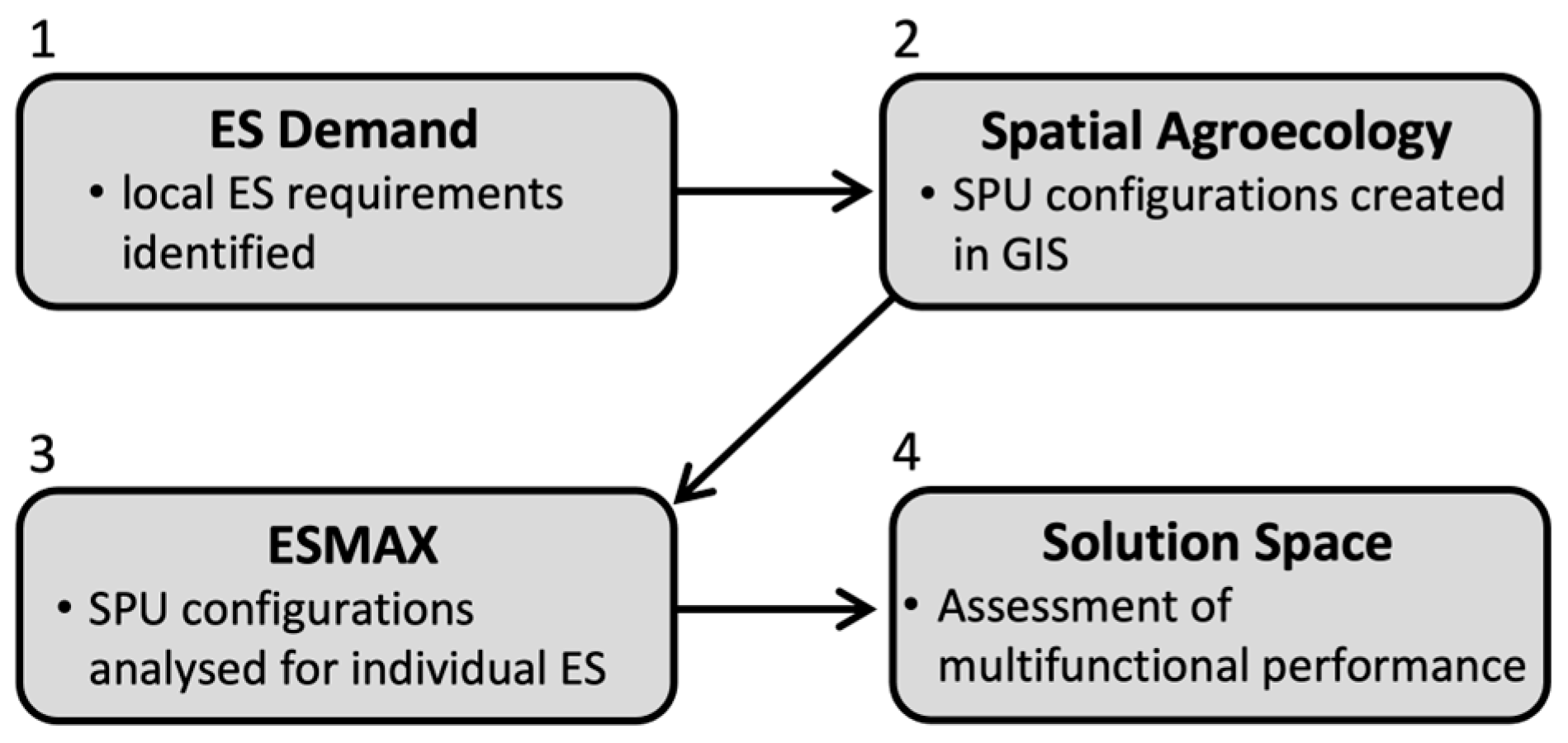
2.3. Spatial Agroecology Methodology

ESMAX is incorporated into a spatially explicit design methodology using the following four steps (Figure 3):
(1)
ES demand—qualitative research identifies the individual ES most demanded from the research area. In this research, ES demand is established as the range of regulating ESs considered most valuable to the existing urban community that neighbours the development site. ES demand could be determined by other means—for example, using climate modelling to establish future demands that will be placed on the site.
(2)
Spatial agroecology—creation in GIS of AFS configurations across the research site, arranging 4 ha and 1 ha AFS parcels in various arrangements. This refers to both the spatial configuration within each AFS parcel and how the parcels are located in relation to each other across the 190 ha development site.
(3)
ESMAX—The ESMAX model is used to quantify and visualise the performance of configurations generated in Step 2 for supplying the specific ES identified in Step 1.
(4)
Solution Space—Analysis of ESMAX results to determine configurations with the multifunctional capability to address local ES demand.

2.4. ES Demand

The ESs that ESMAX assesses in the work were identified as the most prominent among the public submissions made during the rezoning process for the proposed residential development. The three-year rezoning process was characterised by significant public resistance to the proposed change in land use from agricultural to suburban [49]. Qualitative data analysis of public submissions was carried out using NVivo (Version 12, QSR International, Burlington, MA, USA—please refer to Supplementary Materials). Food supply was inferred to be the highest-ranking ES, as the most common cause of objection to the development was the protection of the Highly Productive Land making up the site (Figure 2ii). Food production was excluded when setting demand for targeted ESs, as it is the primary ES supplied in present-day agrosystems and is provided by default. Food supply was followed by the provision of biodiverse habitat and flood mitigation (Figure 4). We investigated biodiversity by examining two indigenous bird species prevalent in the area, whose preferred habitats differ markedly in terms of tree clump size and spacing. The cooling effect was also added to the ESs demanded from this site because of predicted regional warming, noting the likely increasing number of hot days and increased drought risk in the Canterbury Plains [46,50]. Presently, the mean temperature of the Canterbury Plains in summer is 17 °C and in winter 7 °C [50]. Climate change projections (based on Representative Concentration Pathway 8.5, representing a ‘high-end’ emissions scenario with high future global greenhouse gas emissions [50]) suggest the region faces an increasing number of hot days (defined as those hotter than 25 °C), increased drought potential and related impacts on water availability, as well as increased storms, winds and flooding [46].

2.5. Spatial Agroecology Configuration

In this work, each 1 ha and 4 ha AFS parcel is considered to be an SPU. Technically, the individual woody vegetation clumps within the AFS parcels are also SPUs, but to avoid confusion we will refer to these fundamental biophysical features simply as clumps. Figure 5 illustrates the configurations tested in this research. The 1 ha SPUs used here were shown in previous research to provide the best ES performance in cooling (as featured in configurations 1a and 2a), insectivorous bird habitat and flood mitigation (1b and 2b), as well as multifunctional performance across all three ESs (1c and 2c) [27]. The 4 ha SPUs are scaled-up versions of their 1 ha siblings. Given the 5% tree cover typical of farms surrounding Lincoln, we deemed 15% as a reasonably ambitious agroecological transition target. Agroforestry, which broadly describes the agroecological integration of trees on agricultural land, is defined as having 10% tree cover on agricultural land [51,52]. Between the AFS parcels, we showed a generic built-up development zone, comprising buildings, roadways and public open green spaces.
To limit the number of explanatory variables, the SPU configurations are subject to several simplifications. Existing landscape features, including watercourses, soil properties, built infrastructure and trees, are assumed to have a neutral effect, neither increasing nor decreasing ES delivery by the SPUs. The research site topography is assumed to be flat. The total area of SPUs within the 190 ha case study site is a constant 64 ha, and within the SPUs, the woody vegetation cover is a constant 15%. The composition of the woody vegetation clumps within the SPUs is not considered, and it is assumed the trees are at peak maturity, seasonal variations are not accounted for, and the species which are included provide the maximum level of each respective ES.

2.6. ESMAX

The model quantified and visualised the three regulating ESs, as follows, with the woody vegetation clumps within the SPUs being the major sources of the respective regulating ESs:
Habitat suitability—ESMAX is initialised to model the habitat suitability for two indicator species of Indigenous ecosystem resilience in New Zealand rural landscapes [53]. The piwakawaka (fantail, Rhipidura fugilinosa) and korimako (bellbird, Anthornis melanura) are found throughout the country. The piwakawaka is insectivorous, while the korimako is nectivorous [54,55]. Dissimilarities in nesting habitat size requirements and feeding ranges result in distinct ES fields around woody vegetation clumps for each species. Piwakawaka favour habitats along the forest edge, whereas korimako prefer to nest in undisturbed forest environments [53]. The piwakawaka has demonstrated effective adaptation to landscape fragmentation [56,57]. It is renowned for its unique sallying behaviour while feeding, often in close proximity to humans [58]. Conversely, korimako favour undisturbed forest areas for nesting but will sometimes travel considerable distances (exceeding 500 m) to forage on their preferred flowering plants [59].
Flood mitigation—Woody vegetation components provide protection against flooding by obstructing overland water flow and promoting soil infiltration [60,61]. The ES field in this case correlates to root biomass spatial distribution, with root biomass (including both coarse and fine roots) concentrated towards the trunk of an individual tree and the lateral extent of roots extending some distance beyond the crown diameter [62,63]. All tree clumps, irrespective of size, have an associated root architecture extending beyond the above-ground extent of tree clump and this constitutes the range of the ES field included in these flood mitigation calculations. The physical range of the ES field from the clump for flood mitigation is the estimated extent of root structure from the outermost trees in each clump—set at seven metres from the perimeter of the SPU for the purposes of this example, based on a constant five-metre height of individual trees. Due to the particular species of tree modelled for this ES (Alder, Alnus viridis), it is surmised that where root zones of adjacent plants overlap, a high degree of root interweaving results [64]. The capacity to obstruct sub-surface water flows and enhance soil infiltration will be therefore additive in areas of overlap.
Cooling effect—The cooling effect of tree clumps in a rural context has not been as widely studied as the established temperature regulating phenomenon provided by green ‘cooling islands’ in urban contexts [65]. Yet the three variables by which vegetation regulates urban temperatures also apply to tree clumps in rural environments: by shading solar radiation, through the process of evapotranspiration and by altering air movement and heat exchange [66,67]. Research indicates urban cooling is related to the size of the green spaces [67]. Woody vegetation clump size is therefore used by ESMAX as a parameter for cooling intensity, with a range derived from literature on micrometeorological phenomena characteristic of forest edge contexts [68,69]. Equating clump diameter with the cooling effect range is supported by urban cooling research which observed the cooling influence range of urban parks extended approximately the same width of each park away from each respective cooling source park [70,71]. The distance decay of cooling intensity away from the clump is represented by a negative exponential curve, which is verified by empirical and simulated evidence from urban cooling island research [72,73]. For the purposes of this research, only the largest woody vegetation components (0.2 ha, or 50 m diameter) generate any cooling effect on their own. Smaller woody vegetation patches in cooling calculations are only recognised by ESMAX as sources of cooling when they are located within the diameter of the second smallest patch size (11.2 m) from an adjacent patch, and the smallest 5 sq. m patches are excluded from cooling effect calculations [38].

2.7. Solution Space

The output from ESMAX suggests that every research site configuration exhibits some degree of ES trade-off or synergy, where good performance in one ES results in either the reduction or enhancement of the three other ESs [74,75]. Multifunctional landscapes deliver a range of ESs, ideally matching the ES supply to ESs demanded by that ecological and social context [76]. We graph the results as a radar chart to interpret these trade-off/synergy characteristics as a multi-dimensional ‘solution space’, allowing a clear comparison of levels of multifunctional performance across all four ESs [77]. The solution space in this work comprises twelve ‘solution polygons’, each representing one of the twelve case study site configurations illustrated in Figure 5. The vertices of the polygon are located on axes representing the ES Scores of the four individual ESs; hence, the shape of the solution polygons in this work is quadrilateral (i.e., has four vertices). Using a diverse solution space allows comparison of configurations for (1) their supply of the individual regulating ESs prioritised by the local community, and (2) their multifunctional performance collectively across all four ESs. Best multifunctionality is identified as the solution polygon with the greatest geometric area, equivalent to the highest average ES Score across all four ESs. The eccentricity of the solution polygon (i.e., how much the shape deviates from a square, in the case of four ESs), describes the non-uniformity of multiple ESs provision. This can be calculated by summing the difference between ES vertices and the average ES Score for each configuration, with the lower the difference, the more even the distribution of ES performance.

3. Results

3.1. Individual Regulating ESs

For each individual ES, ESMAX generated a diverse range of ES Scores from the different spatial configurations (Figure 6). By providing a spatial mechanism for the provision of targeted ESs, the potential of designed agroecological systems to enhance the resilience of urban environments is demonstrated. The regulating ESs provided are additional to the conventional supply of food and related economic flows to the community.
The findings are summarised as follows:
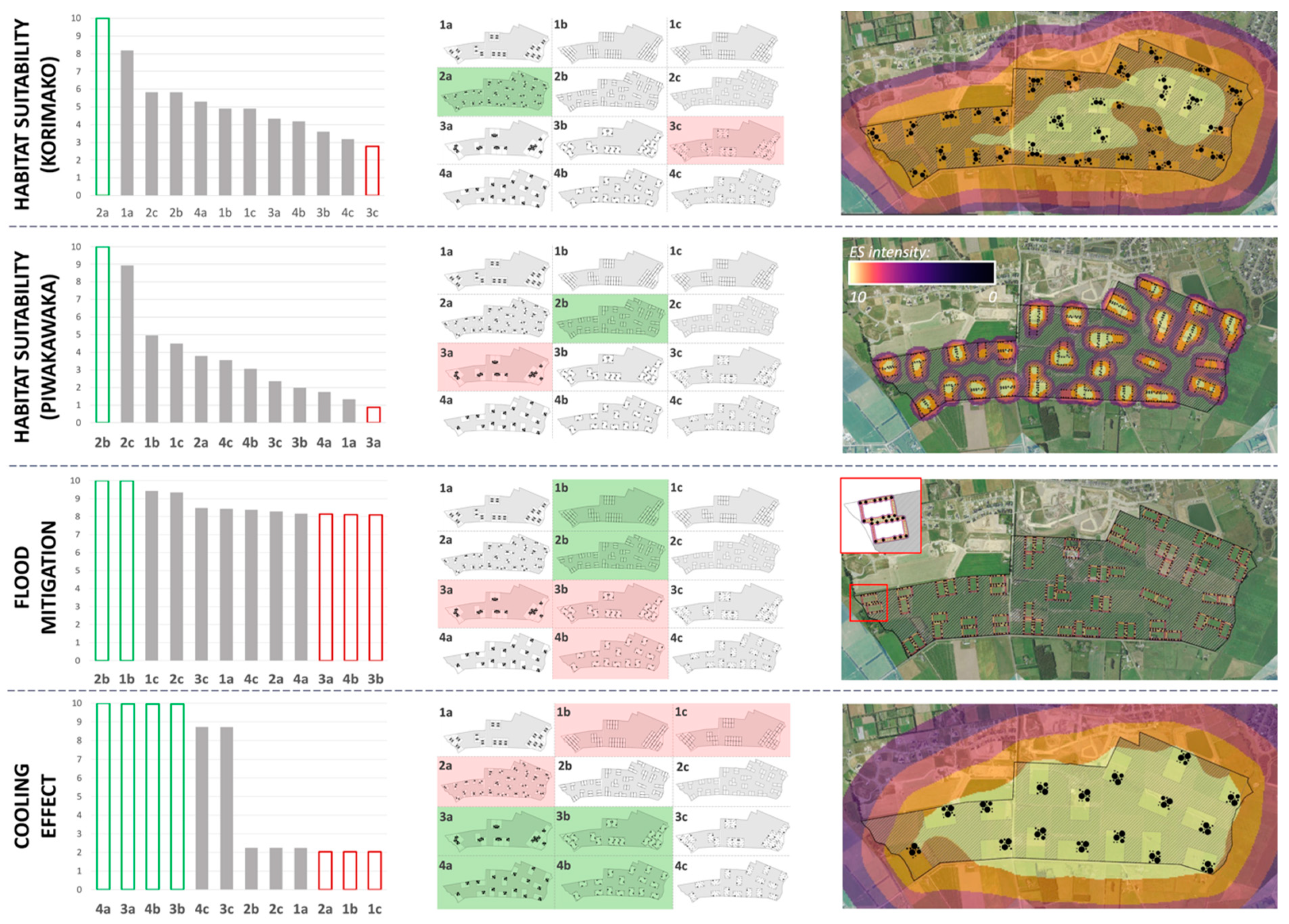
Habitat suitability (korimako): Spatial arrangement is moderately important. Configuration 2a provides the most suitable korimako habitat for this peri-urban site, which comprises dispersed 1 ha SPUs containing L-sized (0.1 ha) clumps. The results indicate the configuration of clumps has a bearing on the korimako habitat, but less so than piwakawaka.
Habitat suitability (piwakawaka): Spatial arrangement is important. The most favourable piwakawaka habitat is provided by the two configurations featuring 1 ha SPUs with shelterbelts (configurations 2b and 2c). There is a 45% drop between these two configurations and the next best habitats. The lowest performing are the configurations that feature the greatest distances (or most space devoid of woody vegetation) between tree clumps of all the configuration options.
Flood mitigation: Configuration exerts a minor influence on ES performance. The best flood mitigation is provided by configuration 2b, which features 1 ha SPUs with shelterbelts, dispersed evenly across the case study site. The shelterbelts include areas of double-row XS clumps, the most closely spaced clumps in any of the SPU options.
Cooling effect: Size matters. ESMAX results indicate that the best cooling effect is provided by four configurations, two of which include the 4 ha SPUs containing XL-sized (0.2 ha) woody vegetation clumps, and the other two featuring 4 ha SPUs containing two L-sized (0.1 ha) clumps. These arrangements have the SPUs both aggregated and dispersed evenly across the site. The results suggest the size of individual SPUs is of primary importance to cooling effect delivery, rather than how these SPUs are arranged.

3.2. Multifunctional Performance
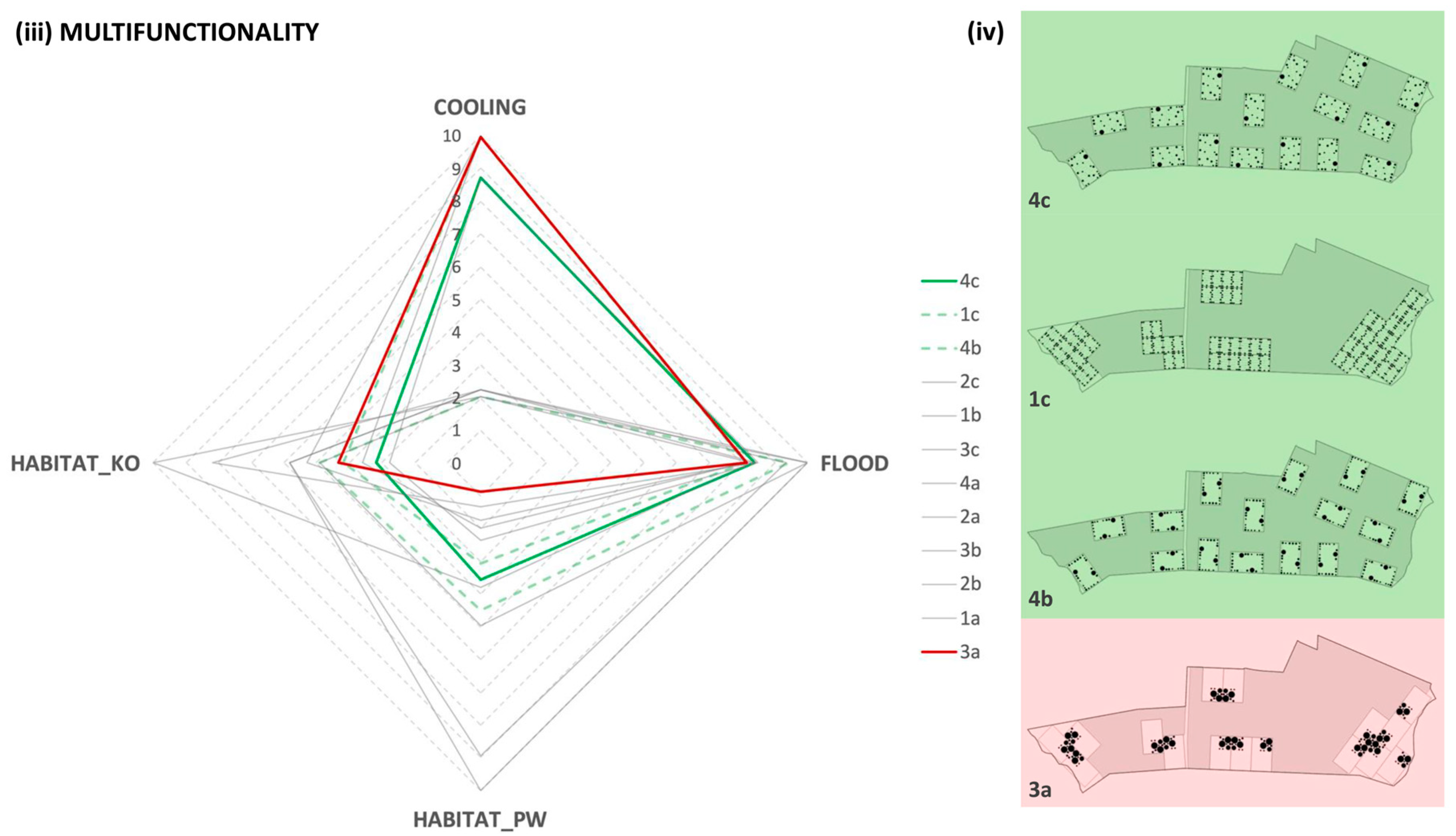
Highest total ES supply—The solution space analysis of the ESMAX results is used to compare the combined provision of the four regulating ESs by the case study site configurations. The results indicate the highest total supply of the four regulating ESs is provided by configuration 2b (Figure 7i), comprising dispersed 1 ha shelterbelt SPUs.
Most even distribution of ESs—The analysis suggests the most even distribution of performance across all four ESs is provided by configuration 4c (Figure 7ii). This is a dispersed arrangement of 4 ha SPUs featuring one L-size 1 ha tree clump set in a silvopastoral arrangement of M-, S- and XS clumps. The next best configuration is 1c, which is an aggregated arrangement of 1 ha silvopasture parcels featuring only S and XS clumps. Note however that although providing a relatively even distribution of ES supply, this configuration provides the second to lowest supply of ESs overall. The third best in terms of even distribution of ESs provided is 4b, a dispersed arrangement of 4ha parcels featuring shelterbelts, which is also the third highest overall supplier of combined ESs. The most uneven or biased supplier of ESs is configuration 3a, the highest-performing provider of cooling effect, and also the lowest provider of all four ESs combined. This configuration features the most clumped arrangement of trees across the site, effectively eight clumps of trees with clear interstitial expanses of pasture and housing.

4. Discussion

Two key points arising from these findings are highlighted here for further discussion. First, we discuss the merits and limitations of ESMAX as a spatially explicit tool for identifying agroecological configurations to provide regulating ESs in a dedensifying urban context. Second, by adopting a spatial agroecological approach, Agroecology for the City identifies a new role for agriculture in the Anthropocene epoch, emphasising its significance to urban systems beyond providing food.

4.1. ESMAX’s Value in an Urban Context

Visualising and quantifying the influence of spatial configuration on regulating ES supply is central to managing the benefits offered by the global reality of urban–rural continuum. The results of this work support the potential of ESMAX, and its integration within the four-step spatial agroecology methodology described in this research, to carry out this function. While it succeeds here as a proof of concept, further application is dependent on ongoing initialisation, testing and empirical validation. However, the results show that the spatial configuration of AFS components, not just the inclusion of a prescribed percentage of green space, determines both individual ES performance and the multifunctionality of a development site. It is the organisation of SPUs that matters, not the arbitrary inclusion of landscape components (in this case, trees) across a given space [12]. Our findings suggest that the even dispersion of SPUs across the development site provides the best multifunctional ES performance. We suggest that this will apply both in planned and in retroactive, adaptative scenarios, whether dispersion is deployed in the design of greenfield developments or applied to existing spatially heterogeneous urban fabrics. While our findings relate only to the four regulating ESs studied here, they align with the Ecology for the City discourse positing the dissolution of rural and urban spaces into a continuum as the most promising spatial design paradigm for Good Anthropocene cities [21]. The continuum is proposed as the ‘most interesting, most radical and therefore least realised’ of the three models for Ecological Urbanism, the other two being the Garden City and Compact City models [21,78]. The Garden City model seeks to contain urban growth with a clearly zoned and demarcated integration of urban and rural functions [79], while Compact Cities focus on urban densification to decrease energy consumption, and consequently reducing the extent of physical expansion into surrounding ecosystems [80,81]. However, as top-down spatial strategies, intended to predict and control the urban–rural interface of city and nature, they are not equipped to address the market-driven inertia and stochasticity of urban dedensification [12]. Conversely, the continuum model is aligned with the complex adaptative and emergent nature of Anthropocene urban systems. Based on the ESMAX results for these four ESs, the spatial agroecology approach is capable of identifying scientifically based spatial patterns potentially capable of engaging with dedensification dynamics in space and time, and potentially reconciling urban expansion with the consolidation and enhancement of regulating ESs [21,82,83].
We recognise that the conceptual approach employed to achieve the principal objective of this research has inherent limitations. However, we suggest that the basic setup of the ESMAX model, structured on 1st- and 2nd-order effects, provides a basis for conducting further research to tackle complexities that were not fully explored here. In terms of 1st-order effects, ESMAX can potentially be expanded to account for variations in SPU size and shape, as well as the species composition of SPUs [84]. The impact of external influences on 1st-order effects could also theoretically incorporate a wide range of variables necessary for ESMAX to be applicable to urban and rural landscape complexities. These 2nd-order effects include soil and hydrographic conditions, variations in topography, and the influence of 1st-order effects from dissimilar SPUs (for example, the interaction between trees and crops, or of 1st-order effects emanating from the interstitial built-up areas of the case study site [85]).

4.2. Agroecology for the City

The old antithesis will indeed cease, the boundary lines will altogether disappear; it will become, indeed, merely a question of more or less populous. There will be horticulture and agriculture going on within the ‘urban regions,’ and ‘urbanity’ without them
H.G. Wells (1902), quoted in Hagan, 2016.
Accepting dedensification as the spatial norm of urbanisation for the existentially critical period remaining in the 21st century aligns with H.G. Well’s prescient image of a continuum of urban and rural land uses becoming typical of what we once considered ‘cities’. If this is the case, our preconception of the rural components of the continuum performing merely a provisioning ES function requires reassessment. Agroecology for the City describes an approach in which agroecological systems are integrated into the peri-urban fabric primarily to provide targeted regulating ESs, thus contributing to the resilience of the whole urban system. Modulation of these AFS components, sitting within a necessary overall systemic re-design required of Good Anthropocene urban systems, presents an opportunity to shift from prevalent and outdated linear patterns of urban resource use towards the circularity and self-organisation observed in natural ecosystems [86,87]. In the New Zealand context, illustrated by our case study, the recognition of agroecological multifunctionality in this work further emphasises the significance of the Highly Productive Land (HPL) at risk due to current patterns of urban expansion. ‘Productive’ in HPL terms has hitherto referred only to agricultural production; largely absent from this discussion is the production of critical regulating ESs [39,88]. The application of the spatial agroecology methodology to HPL has two potential implications. Firstly, it addresses the possibility of integrating HPL into expanding settlement patterns, with the solution space enabling the assessment of multiple alternatives to determine practical solutions in time and space [77,89]. For example, consider the developer of the case study site, who wants to address the multiple ESs demanded by the local community, while still addressing market demand for new housing. Suppose the pattern of existing tree clumps on the site makes impractical the implementation of the highest performing dispersed arrangement of AFS parcels as determined by ESMAX. The solution space diagram in Figure 7 indicates relatively high multifunctionality is also provided by, for example, configuration 3b, an aggregated arrangement of 4 ha parcels with shelterbelts. While the location of the existing trees does not match exactly the shelterbelts shown in the conceptual arrangements, the developer’s design team have a starting point for the iterative application of spatial agroecology, utilising ESMAX and the solution space, to arrive at a compromise site arrangement. Even the incremental improvement in overall multifunctionality achieved by such compromise solutions is a significant contribution to Good Anthropocene urban systems [15]. Second, the application of spatial agroecology is instrumental in protecting the soils of HPL for their utilisation by future generations [90]. Agroecological systems that incorporate woody vegetation components have been shown to enhance a range of critical soil indicators, including soil structure [91,92], nutrient cycling [93,94] and water cycling processes [95,96]. Conversely, continuing with conventional agricultural practices on HPL may not safeguard this soil for future generations [40,97,98].

5. Conclusions

The design of urban systems that allow growth while also protecting and enhancing ecosystem services is identified as an important priority in the Anthropocene. An ecosystem service (ES)-based design paradigm is proposed as such a transformative framework, where the guiding objective of landscape interventions is to maximise the provision of ESs, and in doing so, repair and reinforce planetary boundaries. This work has presented ESMAX as an exercise of this ES-based design approach, visualising and quantifying regulating ESs generated by agroecological components at the peri-urban scale and identifying how ES performance changes depending on how these components are configured. Translating the results of ESMAX to a trade-off/synergy matrix (or ‘solution space’) enables the assessment of multiple solutions and iterative tailoring to meet the spatial and functional constraints of the peri-urban continuum. This work showed that AFS parcels interspersed with built-up areas provide the best level of overall multiple ESs supply—a significant advance in understanding what sustainable urban expansion may look like. Agroecology for the City, and the iterative application of the spatial agroecology method described here, can be utilised to protect highly productive peri-urban farmland, investigate new peri-urban spatial patterns, and educate stakeholders about the fundamental importance of regulating ESs to urban resilience. Methods, such as spatial agroecology, that work with underlying structures such as regulating ESs are critical to exercising the deep (rather than superficial and piecemeal) transformation required by Good Anthropocene urban systems. The main contribution of this work is that hitherto, no spatially explicit frameworks have been put forward to support design based on these critical concepts. While accepting cities can never be perfectly circular, the future development of ESMAX could aim to further enhance circularity by quantifying and visualising urban waste streams (dissipated energy and physical waste), with urban processes seen as a source of ES supply and potentially contributing to the ecosystemic demands of agroecological systems. Another important area for future development is highlighted by the capacity of the solution space to determine specific eccentricities of ES supply, which could be utilised to more closely match quantities of individual ESs supplied with the local demand for those services. Notwithstanding these future developments, the essence of this peri-urban praxis, where agroecology becomes an integral component of coupled human–natural urbanisation, represents a uniquely modern concept—it could only have evolved to address the challenges of a Good Anthropocene. Agroecology for the City does not suggest an ecotopian return to less complex times but rather exposes the need for a new science that integrates urbanisation and agriculture, the two primary anthropogenic contributors to impacts on planetary boundaries.

Supplementary Materials

The following supporting information can be downloaded at: https://www.mdpi.com/article/10.3390/land13101589/s1.

Author Contributions

Conceptualization, R.M.; Investigation, R.M.; Writing—original draft, R.M.; Writing—review & editing, S.D., G.-A.G. and P.G.; Visualization, R.M. All authors have read and agreed to the published version of the manuscript.

Funding

This research received no external funding.

Data Availability Statement

The raw data supporting the conclusions of this article will be made available by the authors on request.

Conflicts of Interest

The authors declare no conflict of interest.

References

  1. Liu, G.; Meng, F.; Huang, X.; Han, Y.; Chen, Y.; Huo, Z.; Chiaka, J.C.; Yang, Q. Forecast urban ecosystem services to track climate change: Combining machine learning and emergy spatial analysis. Urban Clim. 2024, 55, 101910. [Google Scholar] [CrossRef]
  2. Roberts, P.; Carleton, W.C.; Amano, N.; Findley, D.M.; Hamilton, R.; Maezumi, S.Y.; Winkelmann, R.; Laubichler, M.D.; Renn, J. Using Urban Pasts to Speak to Urban Presents in the Anthropocene. Nat Cities 2024, 1, 30–41. [Google Scholar] [CrossRef]
  3. Hamilton, C. The Anthropocene as rupture. Anthr. Rev. 2016, 3, 93–106. [Google Scholar] [CrossRef]
  4. Zalasiewicz, J.; Thomas, J.; Waters, C.; Turner, S.; Head, M. What should the Anthropocene mean? Nature 2024, 632, 980–984. [Google Scholar] [CrossRef] [PubMed]
  5. McPhearson, T.; Raymond, C.M.; Gulsrud, N.; Albert, C.; Coles, N.; Fagerholm, N.; Nagatsu, M.; Olafsson, A.S.; Soininen, N.; Vierikko, K. Radical changes are needed for transformations to a good Anthropocene. NPJ Urban Sustain. 2021, 1, 1–13. [Google Scholar] [CrossRef]
  6. Elmqvist, T.; Andersson, E.; McPhearson, T.; Bai, X.; Bettencourt, L.; Brondizio, E.; Colding, J.; Daily, G.; Folke, C.; Grimm, N.; et al. Urbanization in and for the Anthropocene. Urban Studio 2021, 1, 1–6. [Google Scholar] [CrossRef]
  7. Pereira, L.M.; Bennett, E.; Biggs, R.; Peterson, G.; McPhearson, T.; Norström, A.; Olsson, P.; Preiser, R.; Raudsepp-Hearne, C.; Vervoort, J. Seeds of the Future in the Present-Exploring Pathways for Navigating Towards “Good” Anthropocenes. In The Urban Planet Knowledge Towards Sustainable Cities; Elmqvist, T., Ed.; Cambridge University Press: Cambridge, UK, 2019. [Google Scholar]
  8. Hill, S.B. Redesigning agroecosystems for environmental sustainability: A deep systems approach. Syst. Res. 1998, 15, 391–402. [Google Scholar] [CrossRef]
  9. Steffen, W.; Rockström, J.; Richardson, K.; Lenton, T.M.; Folke, C.; Liverman, D.; Summerhayes, C.P.; Barnosky, A.D.; Cornell, S.E.; Crucifix, M.; et al. Trajectories of the Earth System in the Anthropocene. Proc. Natl. Acad. Sci. USA 2018, 115, 8252–8259. [Google Scholar] [CrossRef]
  10. Rockström, J.; Gupta, J.; Qin, D.; Lade, S.J.; Abrams, J.F.; Andersen, L.S.; McKay, D.I.A.; Bai, X.; Bala, G.; Bunn, S.E.; et al. Safe and just Earth system boundaries. Nature 2023, 619, 102–111. [Google Scholar] [CrossRef]
  11. Keith, M.; Birch, E.; Buchoud, N.J.A.; Cardama, M.; Cobbett, W.; Cohen, M.; Elmqvist, T.; Espey, J.; Hajer, M.; Hartmann, G.; et al. A new urban narrative for sustainable development. Nat. Sustain. 2023, 6, 115–117. [Google Scholar] [CrossRef]
  12. IRP. The Weight of Cities: Resource Requirements of Future Urbanization; Swilling, M., Hajer, M., Baynes, T., Bergesen, J., Labbé, F., Musango, J.K., Ramaswami, A., Robinson, B., Salat, S., Suh, S., et al., Eds.; UNEP: Nairobi, Kenya, 2018. [Google Scholar]
  13. Seto, K.C.; Golden, J.S.; Alberti, M.; Turner, B.L., II. Sustainability in an Urbanizing Planet. Proc. Natl. Acad. Sci. USA 2017, 114, 8935–8938. [Google Scholar] [CrossRef] [PubMed]
  14. Langergraber, G.; Pucher, B.; Simperler, L.; Kisser, J.; Katsou, E.; Buehler, D.; Mateo, M.C.G.; Atanasova, N. Implementing nature-based solutions for creating a resourceful circular city. Blue Green Syst. 2020, 2, 173–185. [Google Scholar] [CrossRef]
  15. Gallopín, G.C. Cities, Sustainability, and Complex Dissipative Systems. A Perspective. Front. Sustain. Cities 2020, 2, 523491. [Google Scholar] [CrossRef]
  16. Viglia, S.; Civitillo, D.F.; Cacciapuoti, G.; Ulgiati, S. Indicators of environmental loading and sustainability of urban systems. Emergy Based Environ. Footpr. Ecol. Indic. 2018, 94, 82–99. [Google Scholar] [CrossRef]
  17. Daily, G.C. Nature’s Services: Societal Dependence on Natural Ecosystems; Island Press: Washington, DC, USA, 1997. [Google Scholar]
  18. Pickett, S.T.A.; Cadenasso, M.L.; Childers, D.L.; Mcdonnell, M.J.; Zhou, W. Evolution and Future of Urban Ecological Science: Ecology In, Of, and For the City. Ecosyst. Health Sustain. 2016, 2, e01229. [Google Scholar] [CrossRef]
  19. Childers, D.L.; Cadenasso, M.L.; Grove, J.M.; Marshall, V.; McGrath, B.; Pickett, S.T.A. An Ecology for Cities: A Transformational Nexus of Design and Ecology to Advance Climate Change Resilience and Urban Sustainability. Sustainability 2015, 7, 3774–3791. [Google Scholar] [CrossRef]
  20. Inostroza, L.; Zepp, H. The metabolic urban network: Urbanisation as hierarchically ordered space of flows. Cities 2021, 109, 103029. [Google Scholar] [CrossRef]
  21. Hagan, S. Ecological Urbanism: The Nature of the City; Routledge: New York, NY, USA, 2015. [Google Scholar]
  22. Artmann, M.; Inostroza, L.; Fan, P. Urban spraw, compact urban development green cities. How much do we know how much do we agree? Ecol. Indic. 2019, 96, 3–9. [Google Scholar] [CrossRef]
  23. Pengue, W.A. Local Food Systems: Making Visible the Invisible Through Urban Agroecology. Front. Sustain. Cities 2022, 4, 867691. [Google Scholar] [CrossRef]
  24. Bennett, E.M.; Chaplin-Kramer, R. Science for the sustainable use of ecosystem services. F1000Research 2016, 5, 2622. [Google Scholar] [CrossRef] [PubMed]
  25. Sutherland, I.J.; Villamagna, A.M.; Dallaire, C.O.; Bennett, E.M.; Chin, A.T.; Yeung, A.C.; Lamothe, K.A.; Tomscha, S.A.; Cormier, R. Undervalued and under pressure: A plea for greater attention toward regulating ecosystem services. Ecol. Indic. 2018, 94, 23–32. [Google Scholar] [CrossRef]
  26. Campbell, E.T.; Tilley, D.R. Valuing ecosystem services from Maryland forests using environmental accounting. Ecosyst. Serv. 2014, 7, 141–151. [Google Scholar] [CrossRef]
  27. Morris, R.; Davis, S.; Grelet, G.; Gregorini, P. ESMAX for spatial agroecology: A conceptual spatial model for the quantification and visualisation of ES performance from different configurations of landscape. Sustain. Agric. Environ. 2024, 3, e12097. [Google Scholar] [CrossRef]
  28. Ryszkowski, L.; French, N.R.; Ke, A. Dynamics of An Agricultural Landscape; Zaklad Badan Srodowiska Rolniczego i Lesnego PAN: Poznan, Poland, 1996. [Google Scholar]
  29. Wojtkowski, P. Agroecology: Simplified and Explained; Springer International Publishing AG: Cham, Cambodia, 2019. [Google Scholar]
  30. Wezel, A.; Casagrande, M.; Celette, F.; Vian, J.-F.; Ferrer, A.; Peigné, J. Agroecological practices for sustainable agriculture. A review. Agron. Sustain. Dev. 2014, 34, 1–20. [Google Scholar] [CrossRef]
  31. Andersson, E.; McPhearson, T.; Kremer, P.; Gomez-Baggethun, E.; Haase, D.; Tuvendal, M.; Wurster, D. Scale and context dependence of ecosystem service providing units. Ecosyst. Serv. 2015, 12, 157–164. [Google Scholar] [CrossRef]
  32. Canet-Martí, A.; Pineda-Martos, R.; Junge, R.; Bohn, K.; Paço, T.A.; Delgado, C.; Alenčikienė, G.; Skar, S.L.G.; Baganz, G.F.M. Nature-Based Solutions for Agriculture in Circular Cities: Challenges, Gaps, and Opportunities. Water 2021, 13, 2565. [Google Scholar] [CrossRef]
  33. Semeraro, T.; Scarano, A.; Pandey, R. Ecosystem Services Analysis and Design through Nature-Based Solutions in Urban Planning at a Neighbourhood Scale. Urban Sci. 2022, 6, 23. [Google Scholar] [CrossRef]
  34. Sharp, R.; Douglass, J.; Wolny, S. InVEST 3.10.2. User’s Guide. In The Natural Capital Project; Stanford University: Stanford, CA, USA, 2020. [Google Scholar]
  35. Bagstad, K.J.; Johnson, G.W.; Voigt, B.; Villa, F. Spatial dynamics of ecosystem service flows: A comprehensive approach to quantifying actual services. Ecosyst. Serv. 2013, 4, 117–125. [Google Scholar] [CrossRef]
  36. Trodahl, M.I.; Jackson, B.M.; Deslippe, J.R.; Metherell, A.K. Investigating trade-offs between water quality and agricultural productivity using the Land Utilisation and Capability Indicator (LUCI)–A New Zealand application. Ecosyst. Serv. 2017, 26, 388–399. [Google Scholar] [CrossRef]
  37. Lavorel, S.; Bayer, A.; Bondeau, A.; Lautenbach, S.; Ruiz-Frau, A.; Schulp, N.; Seppelt, R.; Verburg, P.; van Teeffelen, A.; Vannier, C.; et al. Pathways to bridge the biophysical realism gap in ecosystem services mapping approaches. Ecol. Indic. 2017, 74, 241–260. [Google Scholar] [CrossRef]
  38. Morris, R.; Davis, S.; Grelet, G.-A.; Doscher, C.; Gregorini, P. A Model for Spatially Explicit Landscape Configuration and Ecosystem Service Performance, ESMAX: Model Description and Explanation. Sustainability 2024, 16, 876. [Google Scholar] [CrossRef]
  39. Curran-Cournane, F.; Carrick, S.; Barnes, M.G.; Ausseil, A.-G.; Drewry, J.J.; Bain, I.A.; Golubiewski, N.E.; Jones, H.S.; Barringer, J.; Morell, L. Cumulative effects of fragmentation and development on highly productive land in New Zealand. N. Z. J. Agric. Res. 2023, 66, 1–24. [Google Scholar] [CrossRef]
  40. Koele, N.; Ausseil, A.-G.; Harmsworth, G.; Drewry, J.; Stevenson, B. Our Land 2021; MFE: Wellington, New Zealand, 2021. [Google Scholar]
  41. StatsNZ. 2018 Census Place Summaries. 2018. Available online: https://www.stats.govt.nz/tools/2018-census-place-summaries/ (accessed on 29 September 2022).
  42. Lynn, I.; Manderson, A.; Page, M.; Harmsworth, G.; Eyles, G.; Douglas, G.; Mackay, A.; Newsome, P. Land Use Capability Survey Handbook: A New Zealand Handbook for the Classification of Land; AgResearch: Lincoln, New Zealand, 2009. [Google Scholar]
  43. Kulp, S.A.; Strauss, B.H. New elevation data triple estimates of global vulnerability to sea-level rise and coastal flooding. Nat Commun 2019, 10, 4844. [Google Scholar] [CrossRef]
  44. SDC. Selwyn’s Flooding and Coastal Hazards. Selwyn District Plan Review 2020. Available online: https://apps.canterburymaps.govt.nz/SelwynNaturalHazards/ (accessed on 27 December 2022).
  45. Tipa, G.T. Technical Report to support water quality and water quantity limit setting process in Selwyn Waihora Catchment. Predicting Consequences of Future Scenarios: Cultural Impact Assessment; Environment Canterbury Christchurch: Christchurch, New Zealand, 2014.
  46. Cartwright, A. Canterbury Climate Change Risk Assessment; Tonkin & Taylor Ltd.: Christchurch, NZ, USA, 2022. [Google Scholar]
  47. Walker, S.; Proce, R.; Robbie, P.; Daniel, R.; Stephens, R.T.; Lee, W.G. Recent loss of indigenous cover in New Zealand. N. Z. J. Ecol. 2006, 30, 169–177. [Google Scholar]
  48. Welsch, J.; Case, B.S.; Bigsby, H. Trees on farms: Investigating and mapping woody re-vegetation potential in an intensely-farmed agricultural landscape. Agric. Ecosyst. Environ. 2014, 183, 93–102. [Google Scholar] [CrossRef]
  49. SDC. Private Plan Change Request 69. 2022. Available online: https://www.selwyn.govt.nz/property-And-building/planning/strategies-and-plans/selwyn-district-plan/plan-changes/plan-change-69,-rezone-186-hectares-of-rural-outer-plains-to-living-x,-living-z-and-business-1-zones,-lincoln (accessed on 29 September 2022).
  50. Macara, G.; Woolley, J.-M.; Pearce, P.; Wadhwa, S.; Zammit, C.; Sood, A.; Stephens, S. Climate change projections for the Canterbury Region. In Prepared for Environment Canterbury; National Institute of Water & Atmospheric Research Ltd.: Wellington, NZ, USA, 2020. [Google Scholar]
  51. Nair, P.K.R. An Introduction to Agroforestry: Four Decades of Scientific Developments, 2nd ed.; Kumar, B.M., Nair, V.D., Ebscohost, Eds.; Springer: Cham, Switzerland, 2021. [Google Scholar]
  52. Zomer, R.; Trabucco, A.; Coe, R.; Place, F.; Van Noordwijk, M.; Xu, J. Trees on Farms: An Update and Reanalysis of Agroforestry’s Global Extent and Socio-Ecological Characteristics; Working Paper 179; World Agroforestry Centre (ICRAF): Bogor, Indonesia, 2014. [Google Scholar]
  53. Coleman, G. Nest Site Selection of the New Zealand Fantail (Rhipidura fugilinosa) on South Island Production Land; Department of Zoology, University of Otago: Dunedin, New Zealand, 2008. [Google Scholar]
  54. Fitter, J. A field guide to the birds of New Zealand. In Birds of New Zealand; Merton, D., Fitter, J., Eds.; Princeton University Press: Princeton, NJ, USA, 2011. [Google Scholar]
  55. Higgins, P.J.; Peter, J.M.; Cowling, S.J. Handbook of Australian, New Zealand & Antarctic birds. In Handbook of Australian, New Zealand and Antarctic Birds; Oxford University Press: Melbourne, Australia, 1990. [Google Scholar]
  56. Meurk, C.; Hall, G.; Parkes, J. Options for enhancing forest biodiversity across New Zealand’s managed landscapes based on ecosystem modelling and spatial design. N. Z. J. Ecol. 2006, 30, 131–146. [Google Scholar]
  57. Powlesland, R.G. New Zealand Fantail|Pīwakawaka. New Zealand Birds Online 2022. Available online: www.nzbirdsonline.org.nz (accessed on 28 September 2024).
  58. Berry, L. Edge effects on the distribution and abundance of birds in a southern Victorian forest. Wildl. Res. 2001, 28, 239–245. [Google Scholar] [CrossRef]
  59. Anderson, S.H.; Craig, J.L. Breeding biology of bellbirds (Anthornis melanura) on Tiritiri Matangi Island. Notornis 2003, 50, 75–82. [Google Scholar]
  60. Keesstra, S.; Nunes, J.; Novara, A.; Finger, D.; Avelar, D.; Kalantari, Z.; Cerdà, A. The superior effect of nature based solutions in land management for enhancing ecosystem services. Sci. Total Environ. 2018, 610–611, 997–1009. [Google Scholar] [CrossRef]
  61. Power, A. Ecosystem services and agriculture: Tradeoffs and synergies. Philosophical transactions of the Royal Society of London. Ser. B Biol. Sci. 2010, 365, 2959–2971. [Google Scholar] [CrossRef]
  62. Marden, M.; Lambie, S.; Phillips, C. Biomass and root attributes of eight of New Zealand’s most common indigenous evergreen conifer and broadleaved forest species during the first 5 years of establishment. N. Z. J. For. Sci. 2018, 48, 1–26. [Google Scholar] [CrossRef]
  63. Saint Cast, C.; Meredieu, C.; Défossez, P.; Pagès, L.; Danjon, F. Modelling root system development for anchorage of forest trees up to the mature stage, including acclimation to soil constraints: The case of Pinus pinaster. Plant Soil 2019, 439, 405–430. [Google Scholar] [CrossRef]
  64. Phillips, C.J.; Marden, M.; Lambie, S.M. Observations of “coarse” root development in young trees of nine exotic species from a New Zealand plot trial. N. Z. J. For. Sci. 2015, 45, 13. [Google Scholar] [CrossRef]
  65. Blachowski, J.; Hajnrych, M. Assessing the cooling effect of four urban parks of different sizes in a temperate continental climate zone: Wroclaw (poland). Forests 2021, 12, 1136. [Google Scholar] [CrossRef]
  66. Ryszkowski, L. Managing ecosystem services in agricultural landscapes. Nat. Resour. 1995, 31, 1–46. [Google Scholar]
  67. Zardo, L.; Geneletti, D.; Pérez-Soba, M.; Van Eupen, M. Estimating the Cooling Capacity of Green Infrastructures to Support Urban Planning. Ecosyst. Serv. 2017, 26, 225–235. [Google Scholar] [CrossRef]
  68. Eder, F.; Serafimovich, A.; Foken, T. Coherent Structures at a Forest Edge: Properties, Coupling and Impact of Secondary Circulations. Bound. Layer Meteorol. 2013, 148, 285–308. [Google Scholar] [CrossRef]
  69. Huang, J.; Cassiani, M.; Albertson, J.D. Coherent Turbulent Structures Across a Vegetation Discontinuity. Bound. Layer Meteorol. 2011, 140, 1–22. [Google Scholar] [CrossRef]
  70. Chang, C.-R.; Li, M.-H.; Chang, S.-D. A preliminary study on the local cool-island intensity of Taipei city parks. Landsc. Urban Plan. 2007, 80, 386–395. [Google Scholar] [CrossRef]
  71. Jauregui, E. Influence of a large urban park on temperature and convective precipitation in a tropical city. Energy Build. 1990, 15, 457–463. [Google Scholar] [CrossRef]
  72. Honjo, T.; Takakura, T. Simulation of thermal effects of urban green areas on their surrounding areas. Energy Build. 1990, 15, 443–446. [Google Scholar] [CrossRef]
  73. Lin, W.; Yu, T.; Chang, X.; Wu, W.; Zhang, Y. Calculating cooling extents of green parks using remote sensing: Method and test. Landsc. Urban Plan. 2015, 134, 66–75. [Google Scholar] [CrossRef]
  74. Bennett, E.M.; Peterson, G.D.; Gordon, L.J. Understanding relationships among multiple ecosystem services. Ecol. Lett. 2009, 12, 1394–1404. [Google Scholar] [CrossRef] [PubMed]
  75. Rodríguez, J.P.; Beard, T.D., Jr.; Bennett, E.M.; Cumming, G.S.; Cork, S.J.; Agard, J.; Dobson, A.P.; Peterson, G.D. Trade-offs across Space, Time, and Ecosystem Services. Ecol. Soc. 2006, 11, 28. [Google Scholar] [CrossRef]
  76. Yahdjian, L.; Sala, O.E.; Havstad, K.M. Rangeland ecosystem services: Shifting focus from supply to reconciling supply and demand. Front. Ecol. Environ. 2015, 13, 44–51. [Google Scholar] [CrossRef]
  77. Groot, J.C.J.; Rossing, W.A.H. Model-aided learning for adaptive management of natural resources: An evolutionary design perspective. Methods Ecol. Evol. 2011, 2, 643–650. [Google Scholar] [CrossRef]
  78. Cortinovis, C.; Haase, D.; Zanon, B.; Geneletti, D. Is urban spatial development on the right track? Comparing strategies and trends in the European Union. Landsc. Urban Plan. 2019, 181, 22–37. [Google Scholar] [CrossRef]
  79. Howard, E. Garden Cities of To-Morrow; Mass; MIT Press: Cambridge, UK, 1965. [Google Scholar]
  80. Beatley, T. Preserving Biodiversity: Challenges for Planners. J. Am. Plan. Assoc. 2000, 66, 5–20. [Google Scholar] [CrossRef]
  81. Artmann, M.; Kohler, M.; Meinel, G.; Gan, J.; Ioja, I.-C. How smart growth and green infrastructure can mutually support each other—A conceptual framework for compact and green cities. Ecol. Indic. 2019, 96, 10–22. [Google Scholar] [CrossRef]
  82. Spyra, M.; Inostroza, L.; Hamerla, A.; Bondaruk, J. Ecosystem services deficits in cross-boundary landscapes: Spatial mismatches between green and grey systems. Urban Ecosyst. 2019, 22, 37–47. [Google Scholar] [CrossRef]
  83. Larondelle, N.; Lauf, S. Balancing demand and supply of multiple urban ecosystem services on different spatial scales. Ecosyst. Serv. 2016, 22, 18–31. [Google Scholar] [CrossRef]
  84. Lamy, T.; Liss, K.N.; Gonzalez, A.; Bennett, E.M. Landscape structure affects the provision of multiple ecosystem services. Environ. Res. Lett 2016, 11, 124017. [Google Scholar] [CrossRef]
  85. Carpenter, S.R.; Folke, C.; Norström, A.; Olsson, O.; Schultz, L.; Agarwal, B.; Balvanera, P.; Campbell, B.; Castilla, J.C.; Cramer, W.; et al. Program on ecosystem change and society: An international research strategy for integrated social–ecological systems. Curr. Opin. Environ. Sustain. 2012, 4, 134–138. [Google Scholar] [CrossRef]
  86. Broto, V.C. Energy landscapes and urban trajectories towards sustainability. Energy Policy 2017, 108, 755–764. [Google Scholar] [CrossRef]
  87. Rees, W.E. Cities as Dissipative Structures: Global Change and the Vulnerability of Urban Civilization. In Sustainability Science; Weinstein, M., Turner, R., Eds.; Springer: New York, NY, USA, 2012. [Google Scholar] [CrossRef]
  88. Webb, R.; Bai, X.; Smith, M.S.; Costanza, R.; Griggs, D.; Moglia, M.; Neuman, M.; Newman, P.; Newton, P.; Norman, B.; et al. Sustainable urban systems: Co-design and framing for transformation. Ambio 2018, 47, 57–77. [Google Scholar] [CrossRef] [PubMed]
  89. Alberti, M. Cities that Think Like Planets: Complexity, Resilience, and Innovation in Hybrid Ecosystems; University of Washington Press: Seattle, WA, USA, 2016. [Google Scholar]
  90. MFE. National Policy Statement for Highly Productive Land; MFE: Wellington, New Zealand, 2022. [Google Scholar]
  91. Muchane, M.N.; Sileshi, G.W.; Gripenberg, S.; Jonsson, M.; Pumariño, L.; Barrios, E. Agroforestry boosts soil health in the humid and sub-humid tropics: A meta-analysis. Agric. Ecosyst. Environ. 2020, 295, 106899. [Google Scholar] [CrossRef]
  92. Dollinger, J.; Shibu, J. Agroforestry for soil health. Agrofor. Syst. 2018, 92, 213–219. [Google Scholar] [CrossRef]
  93. Nair, P.K.R.; Buresh, R.J.; Mugendi, D.N.; Latt, C.R. Nutrient cycling in tropical agroforestry systems: Myths and science. In Agroforestry in Sustainable Agricultural Systems; Buck, L.E., Lassoie, J.P., Fernandes, E.C.M., Eds.; Lewis Publishers Inc.: Boca Raton, FL, USA, 1999; pp. 1–31. [Google Scholar]
  94. Palm, C.A. Contribution of agroforestry trees to nutrient requirements of intercropped plants. Agrofor. Syst. 1995, 30, 105–124. [Google Scholar] [CrossRef]
  95. Pavlidis, G.; Tsihrintzis, V.A. Environmental Benefits and Control of Pollution to Surface Water and Groundwater by Agroforestry Systems: A Review. Water Resour. Manag. 2018, 32, 1–29. [Google Scholar] [CrossRef]
  96. Sollen-Norrlin, M.; Ghaley, B.B.; Rintoul, N.L.J. Agroforestry Benefits and Challenges for Adoption in Europe and Beyond. Sustainability 2020, 12, 7001. [Google Scholar] [CrossRef]
  97. Kopittke, P.M.; Menzies, N.W.; Wang, P.; McKenna, B.A.; Lombi, E. Soil and the intensification of agriculture for global food security. Environ. Int. 2019, 132, 105078. [Google Scholar] [CrossRef] [PubMed]
  98. Houlbrooke, D.J.; Paton, R.J.; Littlejohn, R.P.; Morton, J.D. Land-use intensification in New Zealand: Effects on soil properties and pasture production. J. Agric. Sci. 2011, 149, 337–349. [Google Scholar] [CrossRef]
Figure 1. The ESMAX model: (i) ESMAX first assigns a characteristic shape (also referred to as a ‘kernel’) for each type of ES, representing the distance–decay of each ES from its source. The kernel comprises the initial maximum intensity of the ES at its source SPU (represented on the y-axis), the extent of the effect of the ES from its source (the x-axis), and how that effect dissipates with distance away from the SPU, whether in a linear, negative exponential or logistic/sigmoid fashion, for example. This kernel is translated by the model’s Geographic Information System (GIS) platform as an ‘ES field’ that radiates from each SPU. Within the SPU itself, ES intensity is assumed to be at maximum value and constant. When looking at the ES field, the ES distance–decay outside the SPU is illustrated by the transition of yellow (maximum intensity) to black (minimum intensity). This direct impact of the ES from its SPU is referred to as its first-order effect. (ii) Where ES fields overlap, an equation is used to predict the resulting response in ES performance at a particular point in time and space. This response can either be neutral (there is no impact on the two Es fields), negative (the net ES effect is reduced) or positive (there is an amplification of net ESs in the overlapping area). These various effects are termed second-order effects. (iii) ESMAX provides a plan-view visualisation for a configuration of SPUs across the designated research area, which is bounded with a red rectangle (a 1 ha research area and generic ES are shown). The different-sized SPUs represent different sizes of individual groups of woody vegetation plants (or ‘clumps’), here shown concentrated around the perimeter of the research area.
Land 13 01589 g001
Figure 2. The New Zealand case study site: (i) The 190 ha case study site (outlined in red) is located to the south of Lincoln township (white dashed outline). The 2000 homes proposed for the site represent an 85% increase in existing housing numbers and a 35% increase in the land area of the township [41]. Existing urban morphology is illustrated by typical residential blocks (1 ha and 4 ha) outlined in black. (ii) The site is classified in its entirety as Highly Productive Land (HPL). A New Zealand classification system, HPL refers to the most valuable farming land, based on the Land-Use Capability (LUC) of that land. LUC classes land across a range of 1 to 8, with LUC 1, 2 and 3 containing the most versatile and most suitable land, soil and the environmental variables for agricultural production under this New Zealand classification system [42]. HPL is a scarce and finite resource—LUC classes 1 and 2 comprise only 4% of New Zealand’s total land area, while LUC classes 1 to 3 together constitute 14% [40]. (iii) A 200-year flood risk model shows inundation to the eastern and western extents of the site, as well as flood paths from the township transecting the site north to south [43,44]. The site, lying less than 10 m above sea level, formed part of extensive wetlands in pre-European time [45]. Nearby rivers are prone to flooding, with raised embankments (or ‘stopbanks’) a requirement to protect livestock. The nature of flood risk is primarily riverine, exacerbated by sea level rise and the trend towards heavier-intensity rainfall events [46]. (iv) The rezoning masterplan of the development proposed for the site is illustrative of a typical approach to greenfield peri-urban development in New Zealand. Built-up areas are shaded grey, public green spaces are indicated in green and a designated flood relief zone in blue.
Land 13 01589 g002
Figure 3. The 4-step methodology used in this research: (1) NVivo (Version 14.23) is used to analyse public submissions made during the planning consent process of a proposed 190 ha peri-urban residential development of 2000 houses. NVivo is data analysis software for working with qualitative information, such as interviews, documents, and survey data. In this research, it is used to analyse public submissions to the planning process and thus identify which ESs presently provided by the site are considered most valuable to the local community. (2) The 1 ha and 4 ha agroecological farm system (AFS) parcels are arranged in various configurations across the site. In general, the parcels are aggregated into larger continuous expanses of agroecological use, and alternatively, where individual parcels are evenly dispersed across the site. Technically, both the AFS parcels and the woody vegetation clumps within the parcels are Service Providing Units, or SPUs—to avoid confusion, only the parcels are referred to as SPUs. The residual areas between SPUs are set aside for residential development. (3) The ESMAX model visualises and quantifies the different levels of regulating ES performance supplied by the overall development site for the various configurations of SPUs. (4) The results from ESMAX demonstrate trade-offs and/or synergies in ES performance particular to each configuration. These characteristics are used to create a ’Solution Space’ graph, whose shape depicts the multifunctional performance of each site configuration. This allows stakeholders to choose from a range of alternatives that meet ES demand requirements while adapting to spatial constraints (urban planning, farming operations, topography, etc.) specific to the site.
Land 13 01589 g003
Figure 4. ES demand of the case study site. The graph indicates the findings of NVivo analysis of formal public submissions made during the planning consent process for the proposed residential development of the site. Submissions referring to individual ESs were tabulated, shown here divided into provisioning, regulating and cultural ESs. Protection of HPL is the most frequently occurring concern, inferred by this research to mean the provision of food and economic livelihood. Loss of biodiversity and flood mitigation are the next highest-ranking issues. Despite being the least registered factor among present-day public opinion, the cooling effect is included for assessment due to anticipated local warming resulting from climate change.
Land 13 01589 g004
Figure 5. Spatial agroecology configuration options—Individual 1 ha and 4 ha AFS SPUs each contain 15% woody vegetation, with a total SPU area of 64 ha in each configuration. Note that only the 4 ha parcels are large enough to accommodate the largest XL-sized (0.2 ha) clumps due to the 15% constant tree cover limitation. How the clumps of woody vegetation are configured is the subject of a previous research paper [27] and resembles three agroecological typologies: clumped woodlot (configurations 1a,2a,3a,4a), a shelterbelt (or hedgerow) around the perimeter of the AFS parcel (1b,2b,3b,4b) and a silvopastoral arrangement, where woody vegetation clumps are evenly interspersed with pasture and/or crops (1c,2c,3c,4c). The SPUs are arranged in two site-wide general arrangements—aggregated or dispersed. The aggregated arrangements cluster the AFS parcels so that they protect the most valuable LUC classes 1 and 2 land from residential development. They are also concentrated on areas of the site most vulnerable to flood inundation. The dispersed arrangements distribute the AFS parcels evenly across the case study site. Residual space between AFS parcels is shaded to represent the potential area for residential development. The vertical break in the shaded area at the centre left denotes the existing road passing through the proposed development site. For the purposes of this work, the only urban planning consideration is an allowance of 75 m between adjacent SPUs that are not intentionally connected—sufficient to nominally accommodate a street with a row of terraced houses on either side.
Land 13 01589 g005
Figure 6. Individual ES performance. The histograms on the left show the performance of each configuration for each ES. The best and worst-performing configurations are shown in the middle column. The best-performing configurations are coloured green, corresponding to the green bars of the histograms. The worst-performing configurations are coloured red, corresponding to the red bars on the histograms. In the case of flood mitigation, the two top performers and three lowest performers rank equally. In the case of cooling performance, the four top performers rank equally, as do the three lowest performers.
Land 13 01589 g006
Figure 7. The Solution Space. The radar charts on the left present the ‘solution space’ for this research, setting out the multifunctional performance of all case study site configuration options. Each configuration is represented by a ‘solution polygon’—in this case, a quadrilateral polygon, given that four ESs are being tested. Each axis represents one of the ESs, with the vertices of each solution polygon being set by the respective ES Score of each configuration for that ES: (i) Analysis configurations according to the total multiple ESs supplied, based on an area calculation of the solution polygon, with (ii) showing the three configurations coloured green that supply the most combined multiple ESs (in descending order). Configuration 1a supplied the lowest level of ESs, here coloured red. (iii,iv) Highlights the configurations according to how evenly they produce the four ESs. The configurations coloured green provided the most balanced performance across the four ESs measured, while 3a exhibits the most eccentrically shaped solution polygon, and therefore the most weighting towards the supply of a single ES (cooling effect, in this case).
Land 13 01589 g007aLand 13 01589 g007b
Disclaimer/Publisher’s Note: The statements, opinions and data contained in all publications are solely those of the individual author(s) and contributor(s) and not of MDPI and/or the editor(s). MDPI and/or the editor(s) disclaim responsibility for any injury to people or property resulting from any ideas, methods, instructions or products referred to in the content.

