Abstract
Zimbabwe’s woodland and forests have experienced substantial change over the last two decades. In this study, our objective was to assess national-scale spatio-temporal changes in tree loss, wildfire, and population growth since 2000 using global data. Our results showed rates of tree loss were highest in the urbanized Harare and Bulawayo provinces between 2000–2004, followed by Masvingo and Manicaland provinces. We found agricultural versus non-agricultural land type classes had higher tree loss, with the highest rates in small resettlement farms (‘A1’ farms, averaging 5 ha in size) between 2000–2008. The findings from our analysis of wildfire showed burning peaked in 2010, impacting 12% of the country. In the peak fire years of 2008–2012, 30% of A2 self-contained resettlement farms (‘A2’ farms, averaging 318 ha in size) burned, along with 19% of A1 resettlement farms. Analysis of global population data showed increases across all provinces, particularly in large-scale commercial farming areas, with gradual increases seen in A1 and A2 farms. Understanding the trends over two decades and the patterns in three key pressures—tree loss, population change, and fire—provides an important contribution to help guide regional assistance efforts in Zimbabwe.
1. Introduction
The woodlands and forests of Zimbabwe cover almost half of the country and provide a variety of ecosystem services to local and regional communities [1]. However, the country has experienced substantial change over the last two decades in land tenure, agricultural development, and urbanization, large scale and artisanal mining, and increasing drought [2,3].
Zimbabwe is characterized by three main types of woodland—miombo, mopane, and montane. Miombo woodlands are dominated by trees belonging to the subfamily Detarioideae and characterized by the genera Brachystegia and Julbernardia, occurring in the central, mid-altitude areas of the country, while mopane woodlands (Colophospermum mopane) characterize the more arid north and south of the country. Finally, relatively rare Afromontane forests occur in the Eastern Highlands, which harbor exceptionally high biodiversity in some taxonomic groups at a continental scale [4]. Miombo and mopane woodlands have high levels of diversity and endemism in a number of taxonomic groups, including mammals, birds, amphibians, reptiles, and plants, and provide habitat for a variety of animals including endangered and charismatic mammals such as African elephants (Loxodonta africana) and black rhinoceros (Diceros bicornis) [5]. Approximately one-third of Zimbabwe is characterized by savanna or grassland—a mixed tree–grass system characterized by a discontinuous tree canopy in a continuous grass layer, with a range of tree cover from sparsely ‘treed’ grasslands to heavily ‘treed’ woodlands, often along a gradient of increasing precipitation, but also modified by edaphic factors [6].
Studies have put a high value on the ecosystem services provided by miombo and mopane woodlands across southern Africa. Provisioning services such as fuelwood, construction materials, charcoal, and medicines, are estimated to support 100 million rural people and 50 million urban residents, contributing $9 billion a year to rural and urban populations [7,8]. Regulating services provided by Zimbabwe’s woodlands are also notable, including carbon sequestration and storage [9], with significantly higher soil organic carbon content under relatively undisturbed woodlands than on cultivated lands. Sediment retention and regulation of water have also been documented to be better under woodland versus cleared woodland in southern Africa [7]. Finally, cultural services associated with woodlands and forests such as tourism to national parks make a substantial contribution to the country’s gross domestic product, while the spiritual role of Zimbabwe’s sacred forests has long been recognized [10].
Similar to other woodlands and forests across southern Africa, Zimbabwe’s woodlands have been affected by changing patterns of land use with ramifications on the carbon cycle at regional to global scales [11]. The patterns of land use in Zimbabwe changed remarkably in 2000 when the government embarked on its agrarian reform program through the Fast Track Land Reform Program (FTLRP). Through the FTLRP, the government sought to acquire ¾ of the existing 16 million ha of large-scale, commercial farms and re-distribute among more than 150,000 farmers [2,12]. There were two dominant models: the A1 model allocated small plots to landless and poor farmers for growing crops and grazing land (average 5 ha in size) and the A2 model based on self-contained farming units (average size of 318 ha per farmer) for new commercial farmers who had the skills and resources to farm profitably, thereby increasing agricultural productivity [13]. Other land tenure classes include communally owned land and state land. Studies of the FTLRP in Zimbabwe have described a range of impacts of the resettlement program including the permanent clearing of forests for agriculture, reduced fallow periods, and associated environmental degradation such as soil erosion, overgrazing, and excessive resource extraction, and loss of habitat for wild flora and fauna [14,15,16].
Another key feature of the woodlands and savannas in Zimbabwe is fire. Lightning-caused wildfire is an integral component of savanna ecosystems, occurring because of the abundance of a flammable fuel load and a relatively long dry season [17]. Fire and the frequency of fire are important agents of disturbance which help control the distribution and composition of the trees, shrubs, and herbaceous components of savannas [18], for example, through the grass–fire cycle [19]. However, the socio-economic impacts of fire can be substantial, including livestock death and the destruction of field crops, firewood, thatch grass, and trees [20]. Fire also results from human activities and is important to help maintain biodiversity and ecosystem services. Fire in savanna ecosystems is used as an active management strategy to recycle nutrients to improve grassland for grazing, attract wildlife for hunting, and clear agricultural land, as well as reduce the accumulation of fuels to protect trees and settlements from larger fire [21]. Global scale MODIS-derived data have been used in numerous studies to assess trends in fire activity in southern Africa. For example, a global study by Andela et al. [17] shows a decline in the burned area and number of fires for the African continent, although previous work has shown fire occurrence to be strongly linked with precipitation. For example, Andela et al. [22] show a 10.5% increase in annual burned area in southern Africa from 2001–2012 associated with modification of precipitation driven by a change from El Niño to La Niña over the study period.
Our objective in this study was to use globally available datasets to assess trends in tree cover, population, and fire in Zimbabwe over the last two decades and to assess if these data reflected provincial units and land tenure type. Although there have been a number of regional land cover change assessments in Zimbabwe, e.g., the Bindura District [23] or the Mafungabusi Forest in the Midlands Province [24], our study fills an important information gap as there have been few assessments at the national scale assessing trends over multiple years. Quantifying these changes and understanding their spatial distribution can help support natural resource management decisions and undertaking programmatic work within specific regions.
2. Materials and Methods
2.1. Study Area
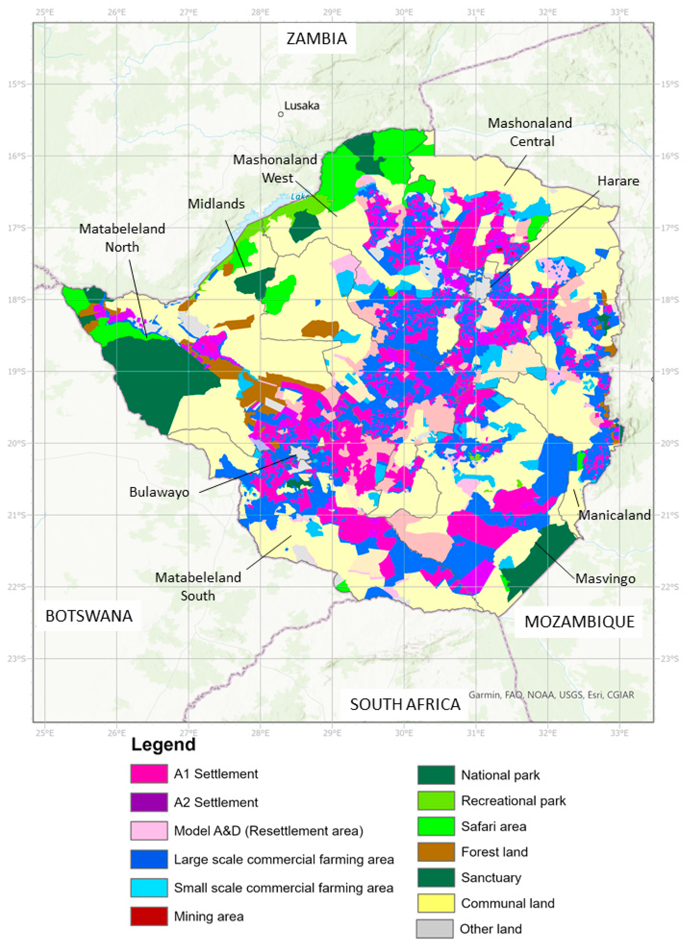
Zimbabwe covers 390,757 km2 and is a landlocked country adjacent to Mozambique, South Africa, Botswana, and Zambia. Zimbabwe is part of the great plateau, with the majority of the land (80%) above 600 m and 5% above 1500 m [25]. The climate ranges from subtropical with dry winters and hot summers in the north, to hot arid and steppe in the south, and higher elevations such as the Highveld and Eastern Highlands having subtropical to temperate climates. Annual rainfall ranges from 400 mm along the Limpopo Valley to 1000 mm in the Eastern Highlands, with rainfall reliability increasing with altitude and from the south to the north of Zimbabwe. Annual temperature ranges from 25 °C to less than 15 °C above 1800 m in the Eastern Highlands. On the basis of the rainfall, soil quality, and vegetation, Zimbabwe is divided into five agro-ecological regions (Natural Regions). The quality of the natural regions declines from Natural Region I through V [26], and different types of agriculture are associated with each. Administratively, Zimbabwe is divided into 10 provinces and 59 districts within these (Figure 1). In addition, we used land tenure data from the Ministry of Land, Agriculture, Water, Climate and Rural Resettlement which depicts a variety of agricultural (A1 and A2 model settlement areas, large and small commercial areas) and non-agricultural areas (e.g., national parks, recreational parks, safari areas) and communal lands. Undertaking a validation of the land tenure data would be valuable, especially if utilized in regional and local scale analyses in the future.
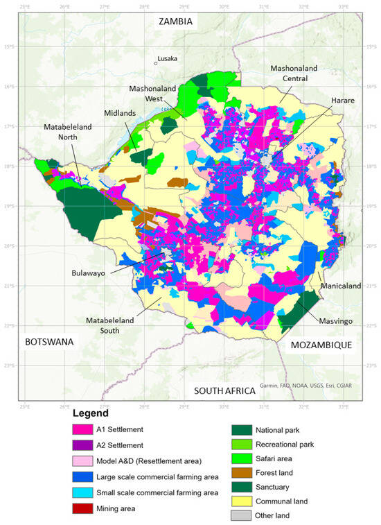
Figure 1.
Land tenure in Zimbabwe with administrative provinces labelled (source: Ministry of Land, Agriculture, Water, Climate and Rural Resettlement).
2.2. Tree Cover
In terms of land cover change, we focused on quantifying trends in tree cover (woodland and forest) given the challenges of detecting trends in savannas and grasslands with global scale data. We compiled available data from the Global Forest Watch tree cover database (https://data.globalforestwatch.org/, accessed on 9 December 2019) from 2000 to 2018. Tree cover loss data are available as a collection of raster geotiff files (30 m resolution, Table 1), which include the amount of tree cover (defined as >10% cover) in the year 2000; a raster indicating if tree cover had been lost in that pixel for each year 2000–2018; and a raster of tree gain from 2000–2012 [27]. The validation reported by Hansen et al. [27] for tree loss in subtropical biomes is 79% (producer’s accuracy). Although the applicability of the Hansen et al. [27] dataset might be questioned given that Zimbabwe is predominantly open canopy savanna, the dataset has been widely used in global and regional studies to assess tree cover change including in regions not dominated by forests. In addition, we focused our calculation of tree loss in pixels which had 20% tree cover in 2000.

Table 1.
Description of global scale data used in study.
To analyze trends in tree loss over time, we aggregated the tree cover loss data to four-year intervals (2001–2004, 2005–2008, 2009–2012, 2013–2016, and a remaining two-year interval 2017–2018) by combining the binary tree loss data available for each year. We summarized tree cover loss data by different analysis units: nationally, by province, and by land tenure type, by extracting the mean and summed values of the tree data within each analysis unit. Within each analysis unit, we computed the ratio of the sum of pixels with tree cover loss over the four-year interval over the number of pixels in the region with tree cover >20% in the year 2000. As such, estimates of change in tree cover relate to 2000, and consequently any loss of trees before 2000 is not reflected. We also report tree gain in Zimbabwe over the 2000–2012 period using data from Hansen et al. [27]. We then plotted the time series of tree loss by analysis unit.
All GIS operations were carried out using GRASS 7 software, with key commands being r.patch to join the raster tiles, r.reclass to aggregate the tree cover loss data by four-year intervals, and r.univar to extract summary statistics across regions of interest. We then plotted these time series by region in R using the libraries ggplot2, cowplot, dplyr, tidyr, and RColorBrewer [28,29,30,31,32].
2.3. Fire
We obtained fire data from the Global Fire Emissions Database (GFED) (https://www.globalfiredata.org/, accessed on 1 June 2020) (Table 1). This database provides information on individual fires over the period 2003–2016 using 500 m resolution MODIS daily burned area data (ORNL Distributed Active Archive Center at https://daac.ornl.gov/cgi-bin/dsviewer.pl?ds_id=1642). A previous study which evaluated the accuracy of GFED with burned area classified from TM imagery (30 m) in lowveld savanna and highveld grassland in South Africa found high levels of correct classification (99% and 97%, respectively), although omission errors of 40% and 60%, respectively [33]. The GFED provides information on the day-to-day spread of fires, rate and direction of spread, and start date (MCD64A1 collection 6). We converted the day-of-the-year raster layers to binary rasters, indicating for each year between 2003 and 2016 whether a fire occurred in a given 500 m pixel. At the national scale we calculated the proportion of total pixels burned by province and land tenure class in a given year (2003–2016) and plotted the yearly values. All GIS operations were performed in GRASS 7, and the time series plots were generated in R.
2.4. Population
We downloaded data from the WorldPop database (100 m spatial resolution, (https://www.worldpop.org/project/categories?id=3, accessed on 1 July 2022) (Table 1) derived using a Random Forest model. We used four-year intervals to allow comparison with the tree cover data by the same time intervals: 2000, 2004, 2008, 2012, 2016, 2018 using the unconstrained WorldPop data for population count. The WorldPop data is derived by integrating geospatial data such as settlement locations, roads, land cover, and satellite mapped nightlights in a Random Forest model to generate a gridded prediction of population density which is used to weight and perform a dasymetric redistribution of census counts as the country level. Stevens et al. [34] performed a comparison of the Random Forest model method with three other global population datasets for Kenya and found it to have the highest accuracy. In our informal comparison to a number of different population datasets, we found WorldPop captured rural populations in more detail than other datasets. We calculated the population growth rate from 2000–2018. We performed this calculation on a pixel-by-pixel basis through a linear regression with the year as an independent variable, using the GRASS 7 add-on module r.regression.series. We also calculated population count by administrative province and land tenure class starting in 2000 and using the four-year class intervals.
To investigate the relationship between the population and tree cover rasters we overlaid 5000 random points across Zimbabwe on a raster of overall tree loss between 2000 and 2018 from the Hansen data (generalized to 1 km resolution), and the WorldPop population density raster for 2018 and conducted a correlation analysis with the extracted tree loss and population data for each point.
3. Results
3.1. Trends in Tree Cover
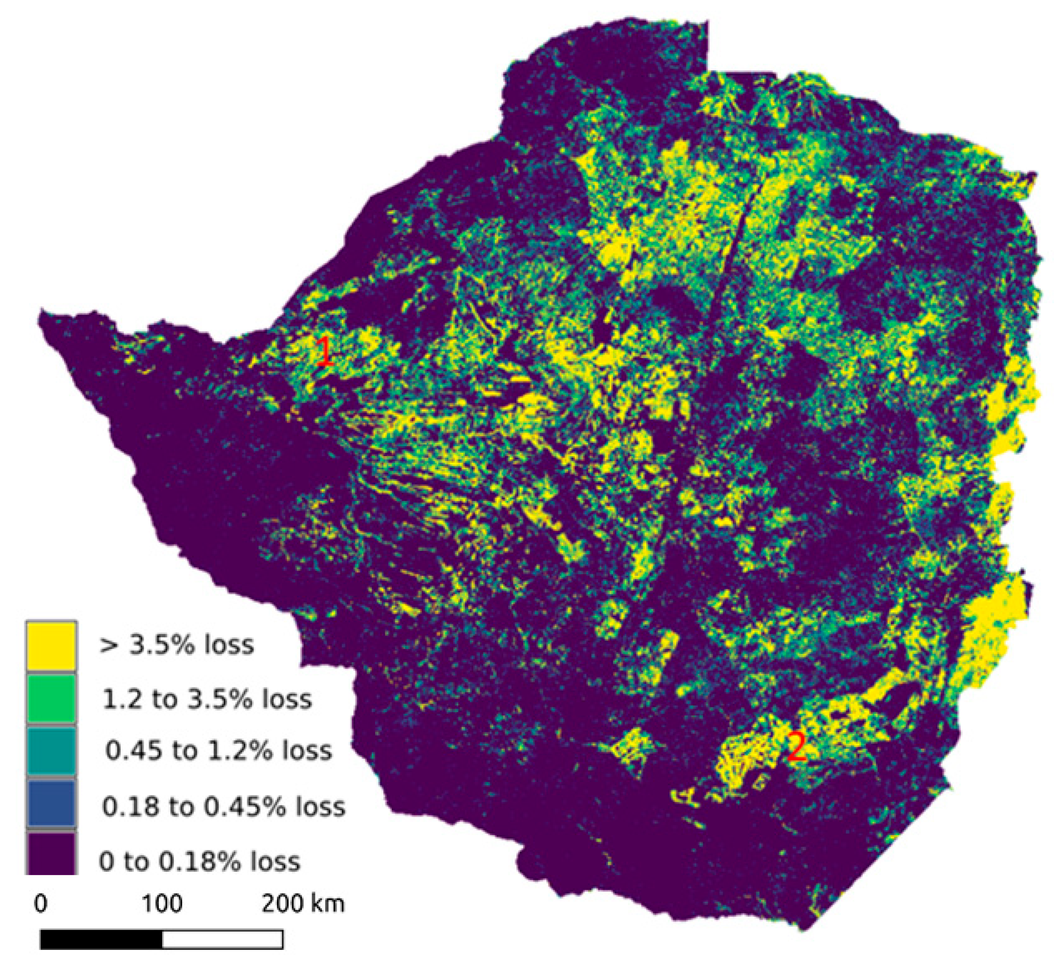
At the national scale, areas with 20% tree cover in 2000 which experienced high total tree loss from 2000–2018 (>=3.5%) included the Eastern Highlands and a large portion of the Midlands, Matabeleland North, and Mashonaland West Provinces (Figure 2). In contrast, areas along the southwestern margin of the country experienced virtually no tree loss (<0.2%). In general, these areas of no or low tree loss overlap with Natural Region V, characterized by low agricultural productivity and low, erratic rainfall. Analyzing the amount of tree loss by four-year intervals showed highest rates of loss averaged over the 4-year periods in 2008–2012, followed by 2004–2008 (Table 2). To place the tree loss figures into context against any potential gains in tree cover, from 2000–2012 Hansen et al. [27] report national tree loss as 3869 km2 compared to tree gain of 486 km2.
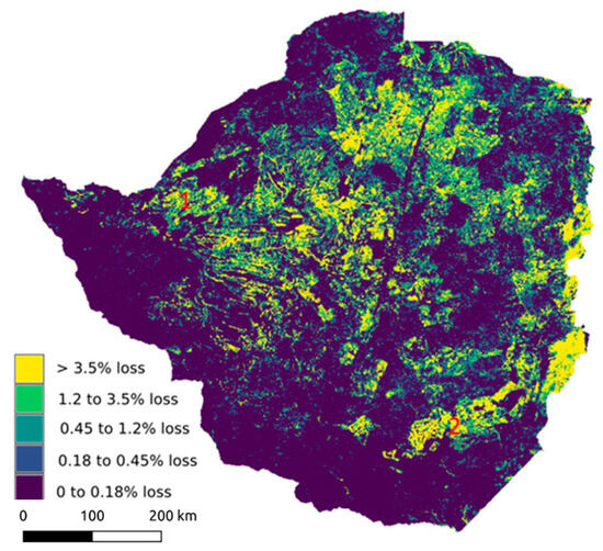
Figure 2.
Tree cover at the national scale 2000–2018 using data from Hansen et al. [27]. Tree loss is calculated as a fraction of the total area of trees with >20% tree cover in 2000.

Table 2.
Trends in tree loss, population, and wildfire from over the last two decades. Fire data are only available for 2003–2016.
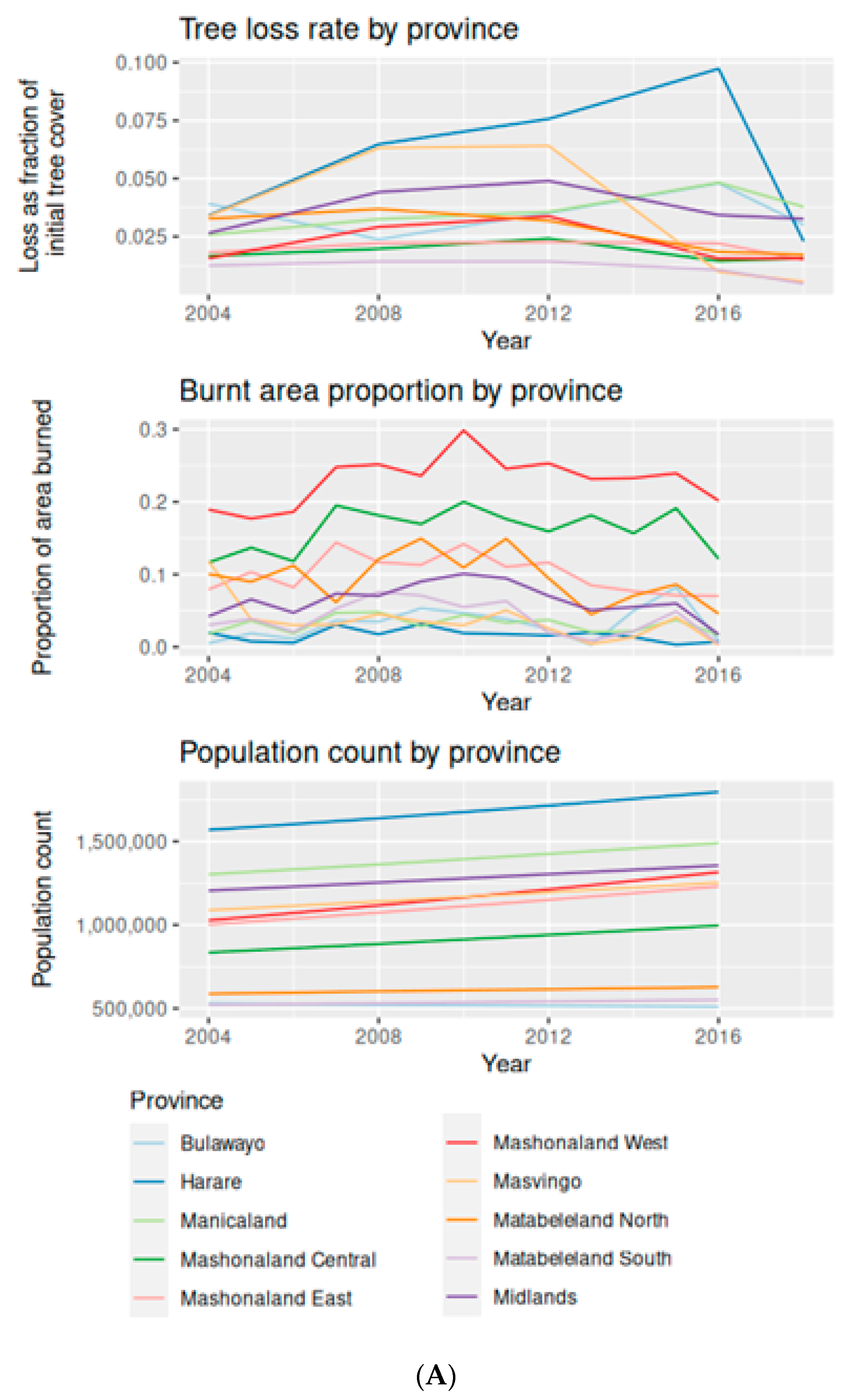
Patterns of tree loss varied dramatically by province (Figure 3A): Harare showed the greatest tree loss, reaching an average of 3.91% over the 2000–2004 interval and, in contrast to the other provinces (except Manicaland), continued to increase until 2016. Masvingo Province in the southeast also showed a dramatic increase in rates of tree loss from 2000–2004 (3.4% during the 4-year period) to 2004–2008 (6.3%), plateauing in the 2008–2012 interval, and then declining in rate from 2012–2016 (1.0%). In fact, some districts within the province, such as the Mwenzi district experienced a 20.2% rate of tree loss in 2010. The province of Manicaland, that encompasses the forests of the Eastern Highlands and commercial timber plantations, showed a steady increase in the rate of tree loss over time, averaging 5.5% during the 2012–2016 interval. Finally, some provinces, such as Mashonaland East, Matabeleland North, and Matabeleland South had low rates of tree loss in 2000–2008 (averaging 2.5%), followed by a decrease (Figure 3A).
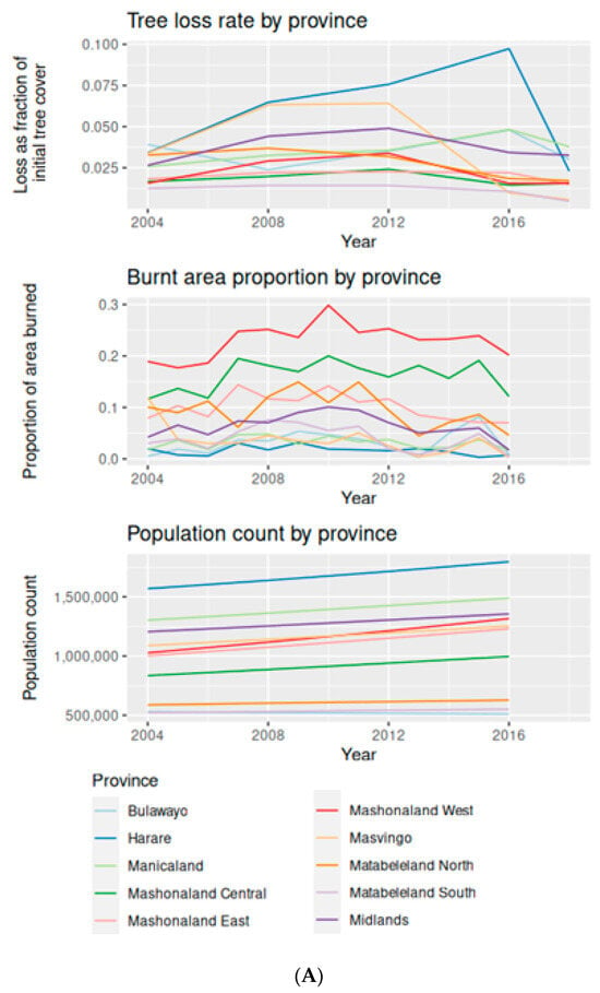
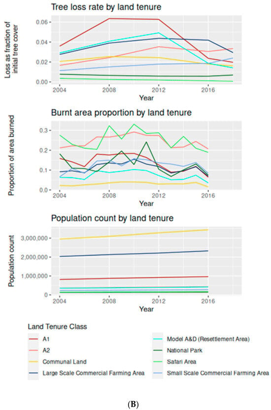
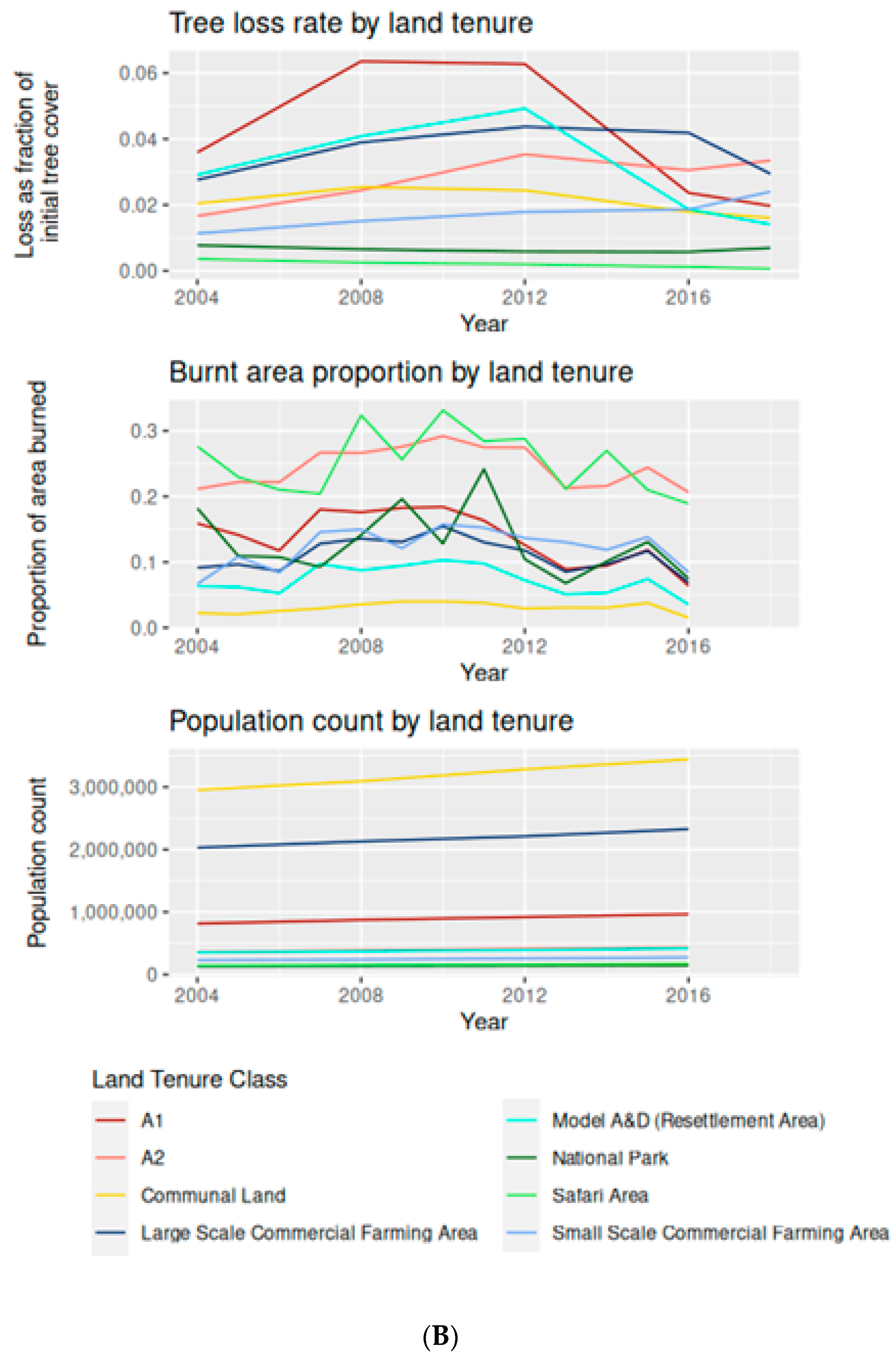
Figure 3.
Trends in tree loss (2000–2018), burnt area proportion, and population count by (A) province and (B) land tenure type.
By land tenure type, distinct differences are visible between agricultural land cover types (A1, A2, small- and large-scale commercial farming) and non-agricultural types (national park, recreational park, safari areas) (Figure 3B). The A1 model farms showed a sharp increase in the rate of tree loss from 2000 to 2008 to 6.4%, after which it plateaued between 2008–2012, and then the amount of tree loss declined between 2012–2016 (Figure 3B). The rate of tree loss on A2 farms, large-scale commercial farms, and small-scale commercial farms all increased steadily from 2000–2012, peaking at 3.5%, 4.4%, and 1.9% tree loss, respectively, before decreasing after 2012. Although these rates appear relatively low, the loss of trees at each timestamp is cumulative, increasing over time. For the non-agricultural land types, such as national parks and safari areas, the rates of tree loss remained steady or decreased over time, e.g., 0–1% for both.
3.2. Trends in Fire
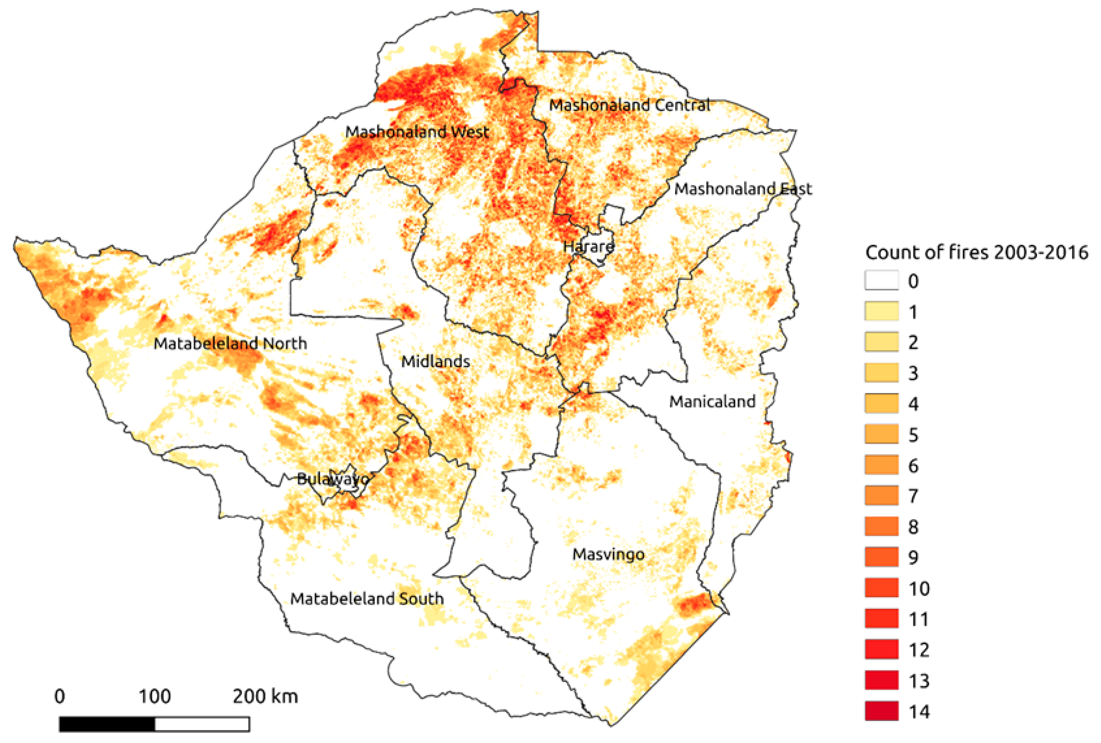
The proportion of area burned in Zimbabwe rose relatively steadily from 6.7% in 2003 to a maximum areal extent of 12% in 2010. The total area that burned in Zimbabwe generally decreased after 2010 to a low of 5.8% in 2016 (Table 2). Across this timeframe, the total count of fires was greatest (maximum of 13 fires) in the north-central part of the country, with other concentrations found in the extreme northwest and southeast corner of Zimbabwe (Figure 4).
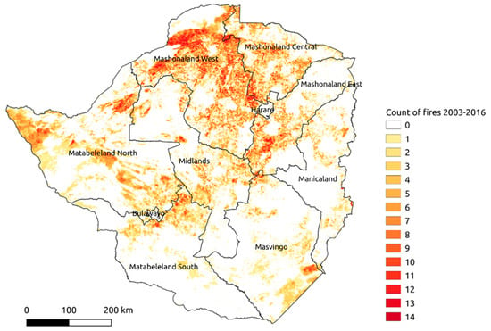
Figure 4.
Total count of fires in Zimbabwe 2003–2016: warmer, redder areas have higher count of fires (source: Global Fire Emissions Database).
By province, Mashonaland West had the highest area burned (29.9% in 2010, Figure 3B), with particular hotspots including the Charara and Hurungwe Safari Areas adjacent to Lake Kariba Recreational Park. Mashonaland Central also had a high proportion of burning peaking at 20.0% in 2010, which was widely distributed across the province (Figure 4). Finally, almost 15% of Matabeleland North burned in 2009, including the Matetsi Safari Area and Ngamo and Gwayi State Forests adjacent to Hwange and Chizarira National Parks. Other provinces, such as Masvingo, had relatively low amounts of burning (<5% from 2005 to 2016), although Gonarezhou National Park was a hotspot of burning within the province.
Patterns of fire by land tenure were variable. In the peak fire year of 2010, 28% of A2 and 17% of A1 model farms burned (Figure 3B), with the proportion of area burned decreasing thereafter. The pattern of burning in safari areas and national parks was erratic over the fire years analyzed (2003–2016), peaking at 30% in 2010 for safari areas and 24% in 2011 for national parks (Figure 3B). In contrast, the proportion of communal lands burned remained relatively steady, below 4% across all years.
3.3. Trends in Population
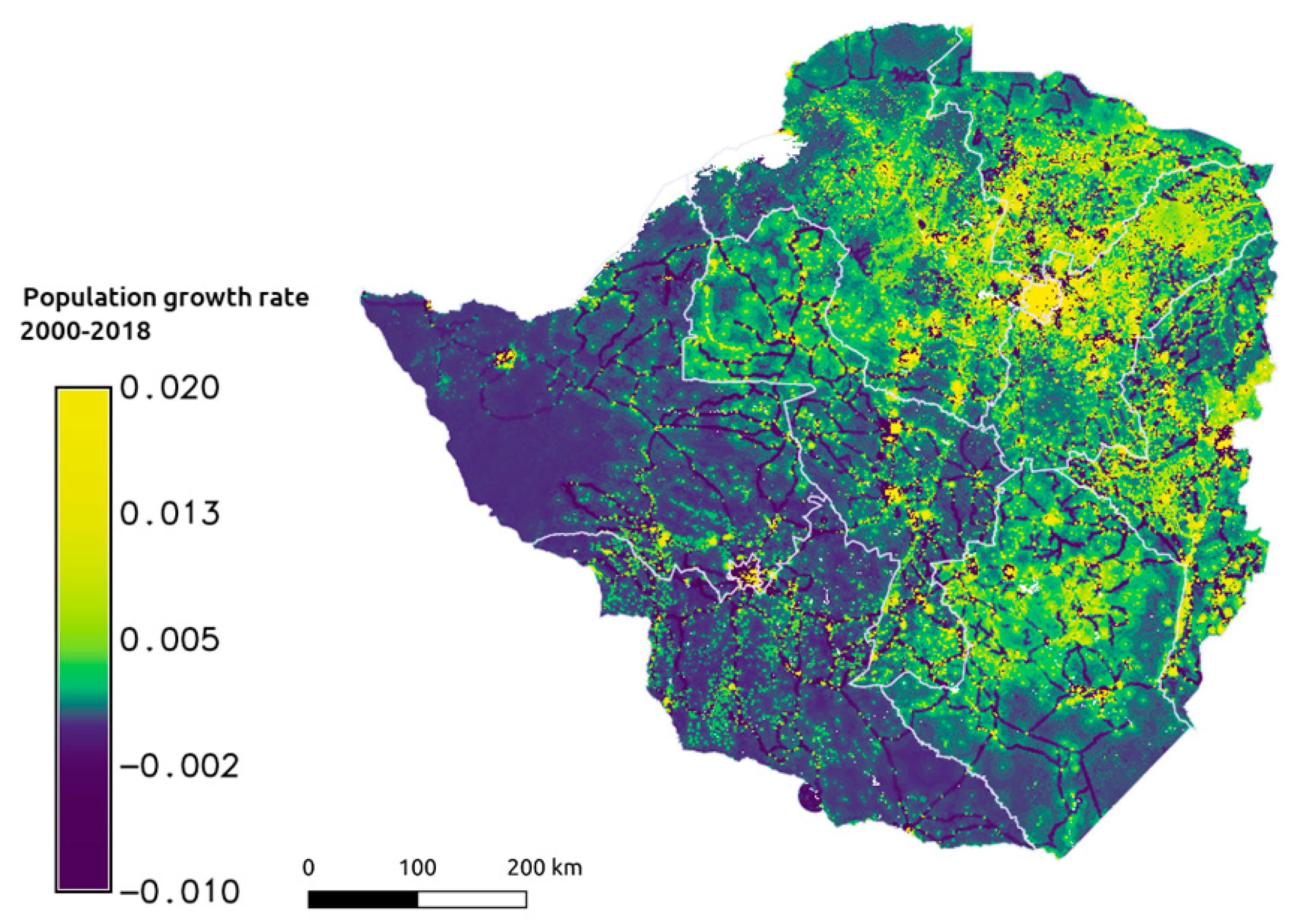
At the national scale, we found that patterns of highest population growth rate (2000–2018) occurred in the north-eastern quadrat of the country, in and around Harare, and also in the south-eastern quadrat centered on Masvingo (Figure 5). In comparison, the growth rate in the south-western quadrat was relatively low. The most recent 4-year period (2012–2018) showed the highest change in population (Table 2).
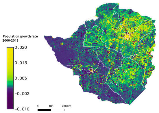
Figure 5.
Change in population growth rate at national scale 2000–2020 (source: WorldPop).
By province, all increased in population count from 2000–2018, except for Bulawayo that decreased slightly (Figure 3A). Among the eight provinces (excluding Bulawayo and Harare), Matabeleland North and Matabeleland South had lower population counts and less increases in people 2000–2016 compared to the other provinces.
By land tenure class, the communal lands saw the largest increase in population, particularly after 2008 (Figure 3B). By agricultural land tenure class, the population of large-scale commercial farming areas increased the most dramatically by 22.3% over the 16 years (Figure 3B). We found a gradual increase over the 16 years of available data in the population of A1 and A2 resettlement areas increasing by 22.2% and 28.6%, respectively. In comparison there was zero or relatively little population change in the non-agricultural classes (Figure 3B).
Finally, we investigated the relationship between tree loss (Figure 2) and change in population (Figure 5) at the national scale. We found a general agreement between both datasets for areas of low population and low tree loss in the southwestern quadrat of the country, in Matabeleland North and Matabeleland South, and also in areas of high population and tree loss in the north-central areas surrounding Harare and also the southern end of the Eastern Highlands. However, the correlation analysis indicated these patterns were not statistically significant. There were notable differences with higher rates of tree loss than would be expected based on population alone in Masvingo and Matabeleland North provinces (labelled 1 and 2, respectively in Figure 2).
4. Discussion
In this study, we used globally available datasets to assess patterns of change in Zimbabwe over the last two decades: tree cover, wildfire, and population growth, and to assess if patterns reflected provincial administrative units and land tenure type. Although using higher resolution data would have been preferable, these datasets had the advantage of a long temporal scale to assess trends; have been calibrated and validated in previous studies; and are readily accessible datasets.
Patterns of tree loss varied considerably based on geographic position. We found a steady increase in tree loss in the Eastern Highlands, which is likely a result of increased commercial timber harvesting, e.g., 90,805 ha in 2008 to 193,534 ha in 2014 (Zimbabwe Forestry Commission annual reports). Findings of increased tree loss since 2000 in the southeastern Masvingo province reflected findings from other studies. For example, Matavire et al. [16] assessed land use change in Quagga Pan Ranch, one of the farms acquired in the FTLRP in 2000: from 2000 to 2010 the authors found a significant decrease in woodland from 5000 to 3000 ha; an increase in field size from 500 ha to 2000 ha; and a significant increase in bare ground associated with 74 households being resettled to the Quagga Pan. In contrast, some provinces experienced relatively low and declining rates of tree loss. This includes Matabeleland South where, again, regional studies can provide insight. Scharsich et al. [35] used Landsat TM to assess vegetation composition in Matobo National Park from 1989–2014. Vegetation cover was stable within the National Park but in adjacent lands forest cover actually increased by approximately 7% which the authors attribute to agricultural land being left fallow and regenerating as people left the country in response to the FTLRP. A concern with tree loss is the associated increase in soil erosion and sediment yield, as documented by Kusena et al. [36] in the Upper Runde subcatchment.
Tree loss driven by agriculture has been recorded across tropical regions globally [37]. In Zimbabwe, we found tree loss within agricultural land tenure classes showed the highest tree loss in the A1 farms between 2000–2008, which experienced loss rates of up to 6%, followed by A2 and large- and small-scale commercial farms, which some authors relate to land clearance associated with the FTLRP. In contrast, communal lands had low and declining rates of tree loss. One explanation is tree cover might have been lost prior to 2000 and so not detected in the Hansen et al. [27] dataset. Also, between 2000–2012 Hansen et al. [27] report a small increase (486 km2) in tree cover which might be attributable to fast growing miombo species, which would signal positive news for some of the ecosystem services provided by natural and semi-natural woodlands.
The occurrence of fire over the last two decades in Zimbabwe has been concentrated in northern central Zimbabwe, with some clustering in the northwestern corner (Figure 4). These spatial patterns reflect other studies, for example, Shekede et al. [38] who identified clusters of fire in the northern part of the country (including Chegutu, Harare, Hurungwe, Hwange, Mazowe, and Makonde districts). Our analysis found fire has been a key component across land tenure types over the last two decades: e.g., 30% of safari areas and 30% of A2 resettlement areas (Figure 3B) experienced burning during this period. Communal lands, however, were an exception, which showed a low occurrence of fire from 2003–2016. Possible explanations include the clearance of trees and fuel before our data collection began or other studies that suggest grazing on communal lands results in less biomass for burning in the dry season or cite the measures and practices employed in communal lands [39].
Previous studies, both international and from southern Africa, using MODIS-derived data, confirm its resolution fails to distinguish different sources of fire or capture small, human-caused fires [3,39,40]. However, there are studies from within Zimbabwe which examined the issue of fire occurrence and human settlements. A number of studies have linked an increase in fire since 2000 with changes in land use and patterns of humans. For example, Nyamadzawo et al. [2] linked increased fire since 2000 to land clearance by smallholding farmers in the A1 resettlement areas which sometimes spread beyond the intended area and contributed to the number of forest fires recorded. Similarly, Maponga et al. [41] found fires are lit for subsistence hunting in A2 resettlement areas which still harbor forests and grasslands and provide habitat for game, while Zisadza-Gandiwa et al. [42] showed fires in Nyanga National Park in the Eastern Highlands were predominantly human-caused in relation to illegal hunting, the extraction of natural resources, and agricultural activities within the park. In contrast, Shekede et al. [38] found a significant increase in fire with increased distance from settlement (as well as a positive correlation of fire to increasing slope, hotter temperatures, and more dry matter). Shekede et al. [38] suggest differences in findings on fire occurrence and land tenure might stem from global scale fire data not detecting sufficient detail. Further analyses at the regional and local scale using finer resolution imagery and land use data could provide additional insights into the spatio-temporal variation in fire patterns. After 2011, we found both the count of fires and area burned declined. Zimbabwe’s Environmental Management Agency [39] attributed this to a public media campaign educating people about the impacts of improper use of fire; regular monitoring of fire incidences; enforcement of regulations by field teams (e.g., fines); and the empowerment of local chiefs by the EMA to fine fire offenders [39].
A continental study of population change using WorldPop data has detected spatial-demographic changes across Africa [43], which the authors found to be only weakly linked to income. In our study, we found patterns of population since 2000 showed a distinction between the less populated areas of Matabeleland North and Matabeleland South in the southwest quadrat of the country compared to the other areas. Although we found no correlation at the province level between population and tree loss, two areas showed a general pattern of relatively high tree loss in less populated areas: the area between Hwange and Binga in the northwest of the country (number 1 in Figure 2) which largely overlaps communal lands and a diagonal southwest to northeast swath through Chiredzi in Masvingo province (number 2 in Figure 2). To investigate these regional patterns further would require delving into the particular histories of land use for each region at a finer spatial scale of analyses. One such regional study by Muhoyi and Muhoyi [44] of the Manyame River Catchment found human settlement, as well as climate, impacted vegetation cover in the catchment.
5. Conclusions
The findings provided in this national scale analysis highlight the spatial variation in tree cover, population, and fire in Zimbabwe. This information, even with the challenges of using global scale datasets, can be used to support natural resource decisions, develop broad management strategies, and guide programmatic work within specific regions. For example, other researchers have called for fire management strategies to take advantage of spatial models to optimize the allocation of resources for fire management and conservation efforts [38,45]. Our findings also highlight areas of Zimbabwe that could be focus of programmatic work. For example, loss of tree cover and subsequent land degradation threaten the health and sustainability of the native ecosystems and the services provided. Degradation can lead to increased erosion and siltation problems, which is further exacerbated by drought. Developing community grazing and watershed management programs or creating native plant nurseries for reforestation, particularly of communal lands, could be valuable activities in areas which have experienced high tree loss. Finally, payment for ecosystem services might provide another way to protect upper watersheds and explore incentives for smallholder farms to allow fields to regrow or developing programs relating to non-timber forest product value chain development. For example, most Zimbabwean tree nurseries currently focus on the production of exotic species such as Eucalyptus, used primarily for poles or other structural purposes, but do not contribute to wood or charcoal for heat and cooking. One option is to incentivize smallholder households to allow exhausted fields to regrow hardy native scrub such as Acacia and Dichrostachys, and convert the woody products to charcoal—as has been successfully demonstrated in Namibia. These types of nature-based interventions can be used to mitigate climate change impacts, while also achieving multiple benefits for people, livelihoods, and nature including improving wildlife habitat, enhanced groundwater recharge, flood risk reduction, and improved agricultural and pastoral lands.
Author Contributions
B.A.H. led the conceptualization of the study and acquired funding; E.C.U., B.A.H. and A.D.H. designed the study; A.D.H. and E.C.U. prepared and analyzed data; E.C.U. led interpretation of results and writing of manuscript; B.A.H. and A.D.H. contributed to writing manuscript. All authors have read and agreed to the published version of the manuscript.
Funding
This research was funding by the US Department of Agriculture Forest Service International Programs with additional support from the US Agency for International Development Africa Bureau.
Data Availability Statement
The data presented in this study are available on request from the corresponding author.
Acknowledgments
We thank Raoul du Toit, David Cumming, Anderson Muchawona, and Jonathan Timberlake for assistance with compiling data and interpretation of findings.
Conflicts of Interest
The authors declare no conflict of interest.
References
- Chawanji, S.; Masocha, M.; Dube, T. Spatial Assessment of Ecosystem Service Trade-offs and Synergies in Zimbabwe. Trans. R. Soc. S. Afr. 2018, 73, 172–179. [Google Scholar]
- Nyamadzawo, G.; Gwenzi, W.; Kanda, A.; Kundhlande, A.; Masona, C. Understanding the Causes, Socio-Economic and Environmental Impacts, and Management of Veld Fires in Tropical Zimbabwe. Fire Sci. Rev. 2013, 2, 2. [Google Scholar] [CrossRef]
- Mpakairi, K.S.; Tagwireyi, P.; Ndaimani, H.; Madiri, H.T. Distribution of Wildland Fires and Possible Hotspots for the Zimbabwean Component of Kavango-Zambezi Transfrontier Conservation Area. S. Afr. Geogr. J. 2018, 101, 110–120. [Google Scholar] [CrossRef]
- Timberlake, J.R. Biodiversity Knowledge from the Chimanimani Trans Frontier Conservation Area. TFCA Final. Rep. 2017.
- Burgess, N.; Hales, J.A.; Underwood, E.; Dinerstein, E.; Olson, D.; Itoua, I.; Schipper, J.; Ricketts, T.; Newman, K. Terrestrial Ecoregions of Africa and Madagascar: A Conservation Assessment; Island Press: Washington, DC, USA, 2004. [Google Scholar]
- Scholes, R.J.; Archer, S.R. Tree–Grass Interactions in Savannas. Annu. Rev. Ecol. Evol. Syst. 1997, 28, 517–544. [Google Scholar]
- Ryan, C.M.; Pritchard, R.; McNicol, I.; Owen, M.; Fisher, J.A.; Lehmann, C. Ecosystem Services from Southern African Woodlands and their Future Under Global Change. Philos. Trans. R. Soc. B 2015, 371, 20150312. [Google Scholar] [CrossRef]
- Dewees, P.A.; Campbell, B.M.; Katerere, Y.; Sitoe, A.; Cunningham, A.B.; Angelsen, A.; Wunder, S. Managing the Miombo Woodlands of Southern Africa: Policies, Incentives and Options for the Rural Poor. J. Nat. Resour. Pol. Res. 2010, 2, 57–73. [Google Scholar] [CrossRef]
- Macave, O.A.; Ribeiro, N.S.; Ribeiro, A.I.; Chaúque, A.; Bandeira, R.; Branquinho, C.; Washington-Allen, R. Modelling Aboveground Biomass of Miombo Woodlands in Niassa Special Reserve, Northern Mozambique. Forests 2022, 13, 311. [Google Scholar] [CrossRef]
- Byers, B.A.; Cunliffe, R.N.; Hudak, A.T. Linking the Conservation of Culture and Nature: A Case Study of Sacred Forests in Zimbabwe. Hum. Ecol. 2001, 29, 187–218. [Google Scholar] [CrossRef]
- Le Quéré, C.; Moriarty, R.; Andrew, R.M.; Canadell, J.G.; Sitch, S.; Korsbakken, J.I.; Friedlingstein, P.; Peters, G.P.; Andres, R.J.; Boden, T.A.; et al. Global Carbon Budget 2015. Earth Syst. Sci. Data 2015, 7, 349–396. [Google Scholar]
- Mkodzongi, G.; Lawrence, P. The Fast-Track Land Reform and Agrarian Change in Zimbabwe. Rev. Afr. Polit. Econ. 2019, 46, 1–13. [Google Scholar] [CrossRef]
- Chirima, A.; Mundy, P.; Ncube, N.; VanRooyen, A.F. Vegetation Changes in the Miombo Woodlands in Northwestern Zimbabwe: A Case Study of Nkayi District 1990 to 2017. 2018. Available online: https://www.intechopen.com/chapters/58979 (accessed on 1 September 2023).
- Hamandawana, H.; Nkambwe, M.; Chanda, R.; Eckardt, F. Population Driven Changes in Land Use in Zimbabwe’s Gutu District of Masvingo Province: Some Lessons from Recent History. Appl. Geogr. 2013, 25, 248–270. [Google Scholar]
- Jewa, E.K.K.; Dougilla, A.J.; Sallua, S.M.; O’Connell, J.B.; Benton, T.G. Miombo Woodland Under Threat: Consequences for Tree Diversity and Carbon Storage. Forest Ecol. Manag. 2016, 361, 144–153. [Google Scholar]
- Matavire, M.M.; Mbulisi, S.; Dube, T. Assessing the Aftermath of the Fast Track Land Reform Programme in Zimbabwe on Land-Use and Landcover Changes. Trans. R. Soc. S. Afr. 2015, 70, 181–186. [Google Scholar] [CrossRef]
- Andela, N.; van der Werf, G.R. Recent Trends in African Fires Driven by Cropland Expansion and El Niño to La Niña Transition. Nat. Clim. Chang. 2014, 4, 791–795. [Google Scholar]
- Bond, W.J.; Woodward, F.I.; Midgley, G.F. The Global Distribution of Ecosystems in a World Without Fire. New Phytol. 2005, 165, 525–538. [Google Scholar]
- Parr, C.L.; Lehmann, C.E.R.; Bond, W.J.; Hoffmann, W.A.; Andersen, A.N. Tropical grassy biomes: Misunderstood, neglected, and under threat. Ecol. Evol. 2014, 29, 205–213. [Google Scholar]
- Chinamatira, L.; Mtetwa, S.; Nyamadzawo, G. Causes of Wildland Fires, Associated Socio-Economic Impacts and Challenges with Policing, in Chakari Resettlement Area, Kadoma, Zimbabwe. Fire Sci. Rev. 2016, 5, 1. [Google Scholar] [CrossRef]
- Shaffer, L.J. Indigenous Fire Use to Manage Savanna Landscapes in Southern Mozambique. Fire Ecol. 2010, 6, 43–59. [Google Scholar]
- Andela, N.; Morton, D.C.; Giglio, L.; Chen, Y.; van der Werf, G.R.; Kasibhatla, P.S.; DeFries, R.S.; Collatz, G.J.; Hantson, S.; Kloster, S.; et al. A Human-Driven Decline in Global Burned Area. Science 2017, 356, 1356–1362. [Google Scholar] [CrossRef]
- Kamusoko, C.; Aniya, M. Land Use/Cover Change and Landscape Fragmentation Analysis in the Bindura District, Zimbabwe. Land Degrad. Dev. 2007, 18, 221–233. [Google Scholar]
- Mapedza, E.; Wright, J.; Fawcett, R. An Investigation of Land Cover Changes in Mafungabusi Forest, Zimbabwe Using GIS, Remote Sensing and Participatory Mapping. Appl. Geogr. 2002, 23, 1–21. [Google Scholar]
- Gwitira, I.; Murwira, A.; Shekede, M.D.; Masocha, M.; Chapano, C. Precipitation of the Warmest Quarter and Temperature of the Warmest Month are Key to Understanding the Effect of Climate Change on Plant Species Diversity in Southern African Savannah. Afr. J. Ecol. 2014, 52, 209–216. [Google Scholar]
- Moyo, S. (Ed.) Zimbabwe Environmental Dilemma: Balancing Resource Inequities; Environmental Research Organization: Harare, Zimbabwe, 2000. [Google Scholar]
- Hansen, M.C.; Potapov, P.V.; Moore, R.; Hancher, M.; Turubanova, S.A.; Tyukavina, A.; Thau, D.; Stehman, S.V.; Goetz, S.J.; Loveland, T.R.; et al. High-Resolution Global Maps of 21st-century Forest Cover Change. Science 2013, 342, 850–853. [Google Scholar]
- Neuwirth, E. RColorBrewer: ColorBrewer Palettes. R Package Version 1.1-2. 2014. Available online: https://cran.r-project.org/package=rcolorbrewer (accessed on 1 December 2023).
- Wickham, H. ggplot2: Elegant Graphics for Data Analysis; Springer: New York, NY, USA, 2016. [Google Scholar]
- Wilke, C.O. Cowplot: Streamlined Plot Theme and Plot Annotations for ‘ggplot2’. R Package Version 1.1.1. 2020. Available online: https://cran.rproject.org/package=cowplot (accessed on 1 December 2023).
- R Core Team. R: A Language and Environment for Statistical Computing; R Foundation for Statistical Computing: Vienna, Austria, 2021; Available online: https://www.r-project.org/ (accessed on 1 December 2023).
- Wickham, H.; François, R.; Henry, L.; Müller, K. dplyr: A Grammar of Data Manipulation. R Package Version 1.0.7. 2021. Available online: https://cran.r-project.org/package=dplyr (accessed on 1 December 2023).
- Tsela, P.L.; van Helden, P.; Frost, P.; Wessels, K.; Archibald, S. Validation of the MODIS Burned-Area Products Across Different Biomes in South Africa. In Proceedings of the 2010 IEEE International Geoscience and Remote Sensing Symposium, Honolulu, HI, USA, 25–30 July 2010. [Google Scholar] [CrossRef]
- Stevens, F.R.; Gaughan, A.E.; Linard, C.; Tatem, A.J. Disaggregating Census Data for Population Mapping using Random Forests with Remotely-Sensed and Ancillary Data. PLoS ONE 2015, 10, e0107042. [Google Scholar]
- Scharsich, V.; Mtata, K.; Hauhs, M.; Lange, H.; Bogner, C. Analysing Land Cover and Land Use Change in the Matobo National Park and Surroundings in Zimbabwe. Remote Sens. Environ. 2017, 194, 278–286. [Google Scholar]
- Kusena, W.; Chemura, A.; Dube, T.; Nicolau, M.D.; Marambanyika, T. Landuse and Landcover Change Asessment in the Upper Runde sub-catchment, Zimbabwe and Possible Impats on Reservoir Sedimentation. Phys. Chem. Earth Parts 2022, 126, 103105. [Google Scholar]
- Pendrill, F.; Gardner, T.A.; Meyfroidt, P.; Persson, U.M.; Adams, J.; Azevedo, T.; Bastos Lima, M.G.; Baumann, M.; Curtis, P.G.; De Sy, V.; et al. Disentangling the Numbers Behind Agriculture-Driven Tropical Deforestation. Science 2022, 377, eabm9267. [Google Scholar] [CrossRef]
- Shekede, M.D.; Gwitira, I.; Mamvura, C. Spatial Modelling of Wildfire Hotspots and Their Key Drivers Across Districts of Zimbabwe, Southern Africa. Geocarto Int. 2021, 36, 874–887. [Google Scholar]
- EMA (Environmental Management Authority). Fire Assessment Report. In Environmental Management Agency; Benaby Printing and Publishing: Harare, Zimbabwe, 2011. [Google Scholar]
- Zhang, Y.; Lim, S.; Sharples, J.J. Modelling Spatial Patterns of Wildfire Occurrence in South-Eastern Australia. Geomat. Nat. Hazards Risk 2016, 7, 1800–1815. [Google Scholar]
- Maponga, R.; Ahmed, F.; Mushore, T.D. Remote Sensing-Based Assessment of Veld Fire Trends in Multiple Interwoven Land Tenure Systems in Zimbabwe. Geocarto Int. 2018, 33, 612–626. [Google Scholar]
- Zisadza-Gandiwa, P.; Gandiwa, E.; Matokwe, T.B.; Gwazani, R.; Mashapa, C.; Muboko, N.; Mudangwe, S. Preliminary assessment of vegetation fires and their impact in Nyanga National Park, Zimbabwe. Greener J. Biol. Sci. 2014, 4, 9–017. [Google Scholar]
- Dorward, N.; Fox, S.; Statham, T.; Wolf, L.J. A Spatial-Demographic Analysis of Africa’s Emerging Urban Geography. Environ. Urban 2023, 35, 310–327. [Google Scholar] [CrossRef]
- Muhoyi, H.; Muhoyi, E. Potential of GIS and Remote Sensing in Mapping Land Degradation: Catchment of the Manyame River, Zimbabwe. Water Pract. Technol. 2023, 18, 455–469. [Google Scholar]
- Dlamini, W.M. A Bayesian Belief Network Analysis of Factors Influencing Wildfire Occurrence in Swaziland. Environ. Model Softw. 2010, 25, 199–208. [Google Scholar]
Disclaimer/Publisher’s Note: The statements, opinions and data contained in all publications are solely those of the individual author(s) and contributor(s) and not of MDPI and/or the editor(s). MDPI and/or the editor(s) disclaim responsibility for any injury to people or property resulting from any ideas, methods, instructions or products referred to in the content. |
© 2024 by the authors. Licensee MDPI, Basel, Switzerland. This article is an open access article distributed under the terms and conditions of the Creative Commons Attribution (CC BY) license (https://creativecommons.org/licenses/by/4.0/).

