
A Land Administration Data Exchange and Interoperability Framework for Kenya and Its Significance to the Sustainable Development Goals

 ,
, 
 , and
, and
Abstract
1. Introduction
2. Methodology
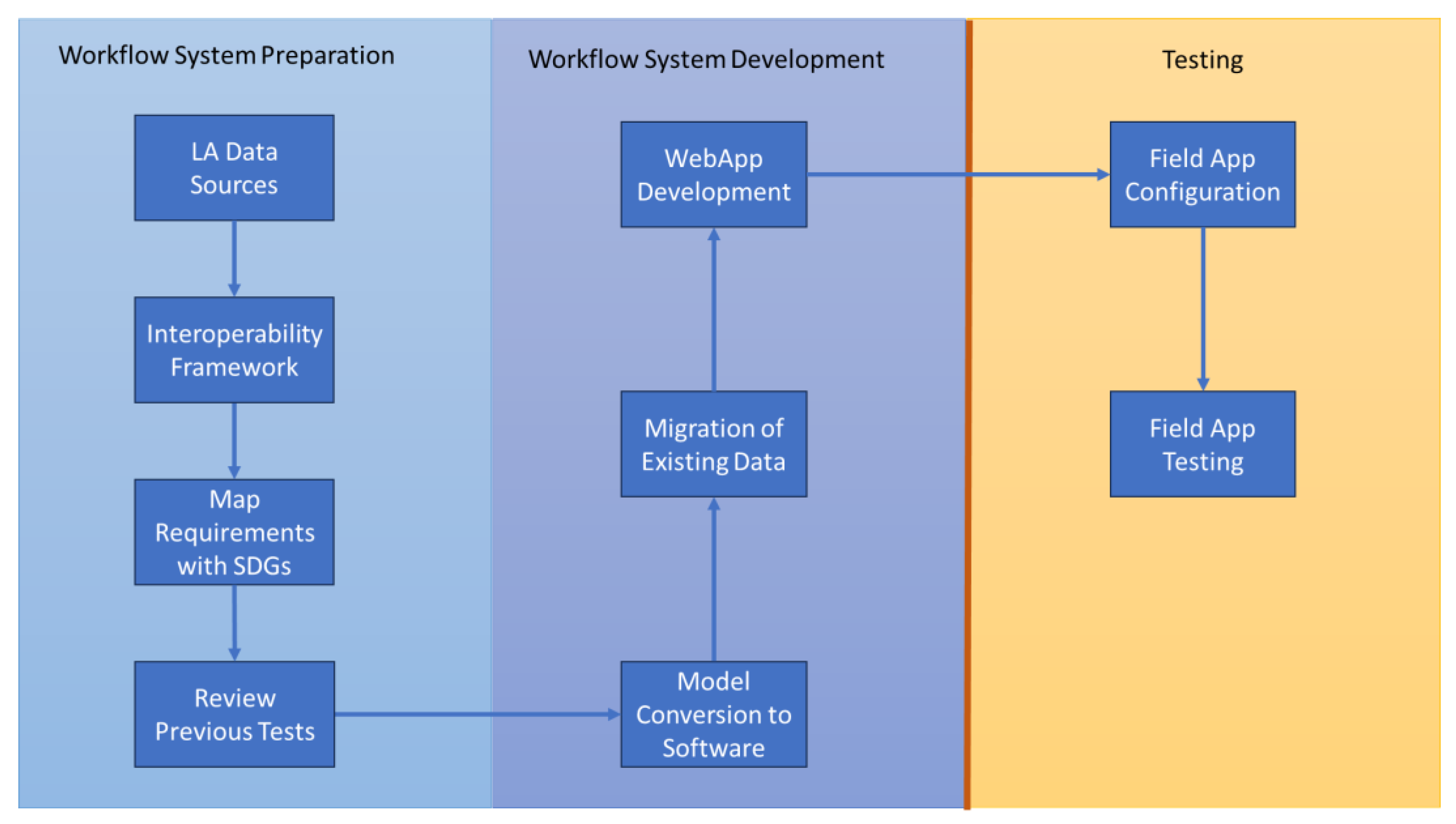
- Land administration data sources: the first stage concerns the mapping of all the LA data sources with the authorities responsible for their creation and management. This includes not only the land departments or cadastre and registry, but also the other external data sources necessary for LA functions: land tenure, land use, land value and land development [19]. This stage is discussed in Section 3.
- 4.
- Review the previous tests: several tests have been conducted on implementing the LADM. Makueni County in Kenya performed a technical test on the Social Tenure Domain Model (STDM) based on a fit-for-purpose (FFP) approach in 2017 [21] and a recent one in Colombia on the LADM [22]. This gives this test a perspective of the success and challenges faced that are to be considered for improvement. This stage is discussed in Section 7.
- 5.
- Deploy the Kenyan profile into a geographic information system (GIS) software system: the LADM profile for Kenya developed [1] is based on the Unified Modeling Language (UML) that is translated to any database management system (DBMS) preferred. The model is converted into a GIS system schema in GIS software. This step makes the model ready for implementation and use in the other steps as discussed in Section 8.2.
- 6.
- Migrate existing data: there exist parcel data that are available on a digital format. In this stage, the existing data are migrated and entered into the database based on the LADM profile for Kenya as discussed in Section 8.3.
- 7.
- Develop a web application based on the Kenyan profile: web services are necessary for the sharing of information to a wider audience through the Internet [23]. Those services can enable the collaboration of different people involved in land administration processes in different locations and roles. At this stage, a web application is developed to facilitate access of information to all stakeholders in the field and those in offices as discussed in Section 8.4.
- 8.
- Configure the field app tool based on the Kenyan profile: a field data collection tool is developed within an application with a simple and easy-to-use interface. The Colombian case recommends the Field Maps (formerly Collector) app [22], and this is used for this second test in Kenya too. This stage is discussed in Section 8.5.
- 9.
- Field app testing: field data collection is partly based on the experiences from 2017 in Makueni County [21] and partly from Colombia in 2021 [22]. The collection of the identities of the landowners is performed through photographs and digital signatures and fingerprints. This is combined with an actual boundary delineation and entry of the related administration data. This stage includes activities of grassroots surveyors, property owners, professional surveyors, officers from land registry, land administration offices and local security and administration officers like area chiefs. This stage is discussed in Section 8.6.
3. Sources of Data for Exchange and Interoperability
4. Requirement for Interoperability in Kenya
5. Kenya Framework for Interoperability in Land Administration
5.1. Interoperability Concerns for Kenya
5.2. Interoperability Barriers in Kenya
5.3. Interoperability Approach for Kenya
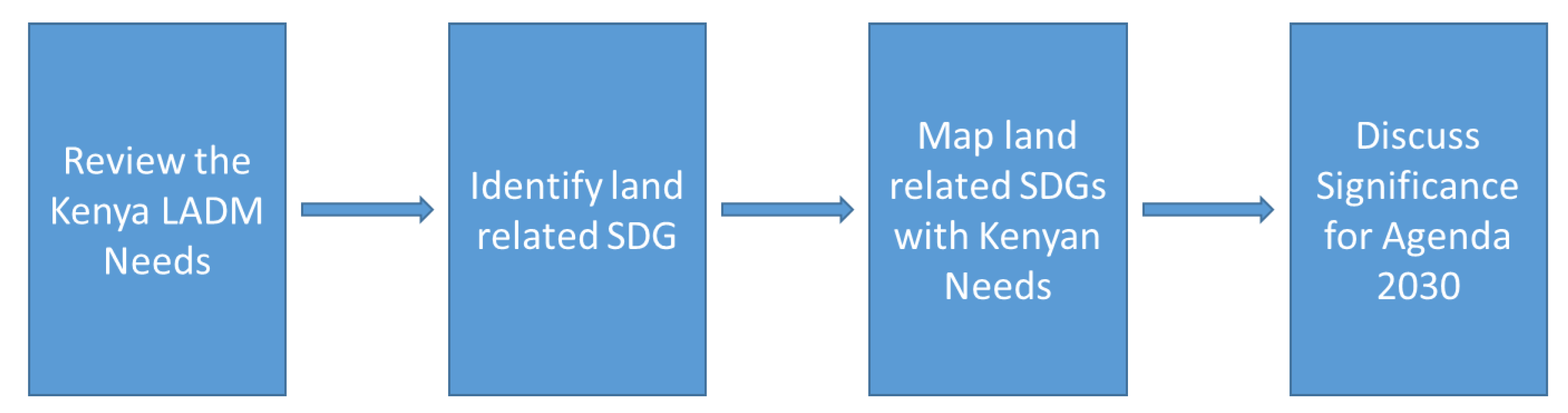
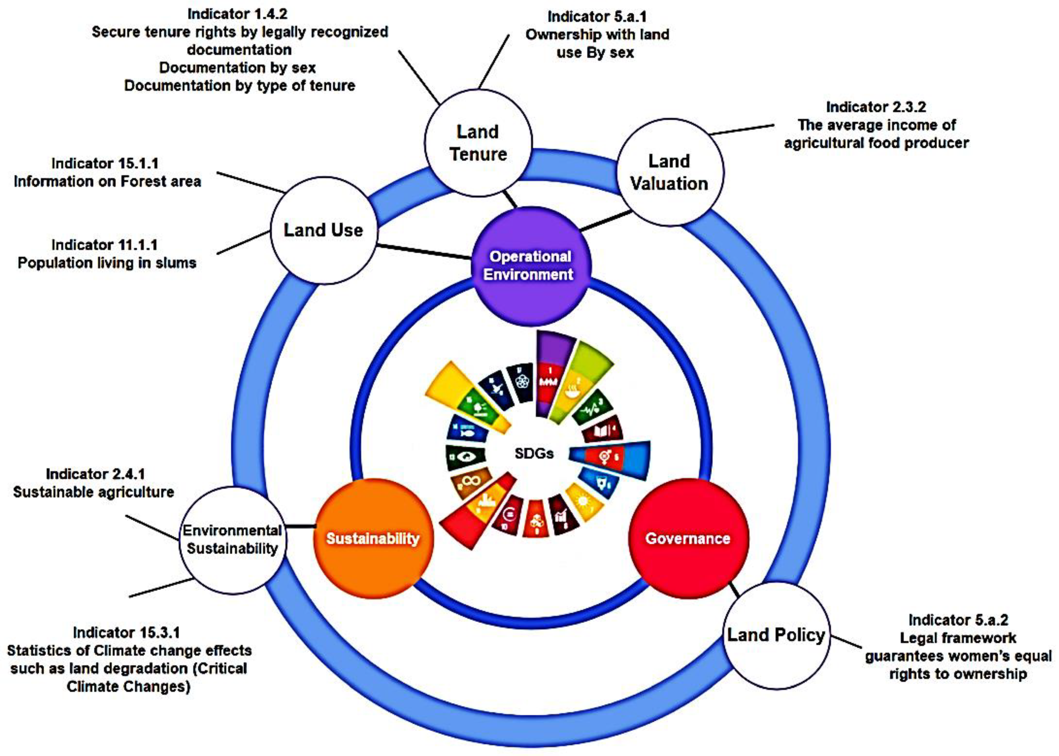
6. Mapping the Kenyan LADM Unique Requirements with SDGs
7. Colombia and Kenya Testing Review
8. LADM Implementation Test in Kenya
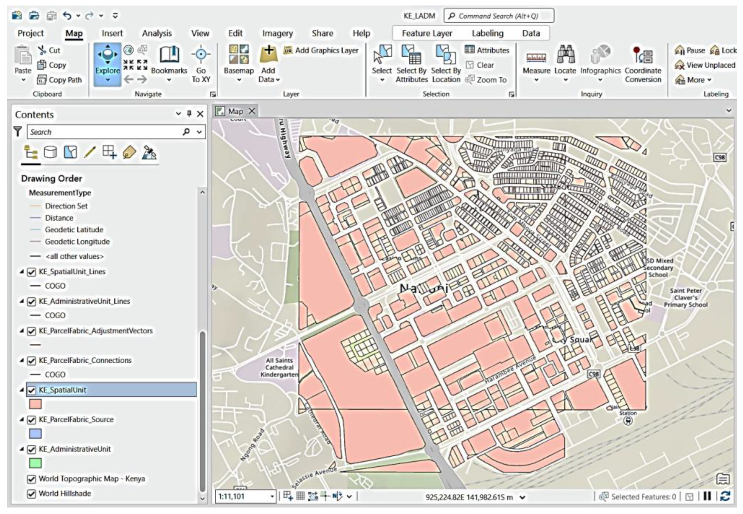
8.1. Test Area: Nairobi and Kajiado Counties
8.2. Model Conversion to Software
8.3. Migration of Existing Data
8.4. Web App Development
8.5. Field App Configuration
8.6. Field App Testing
9. Discussions
10. Conclusions and Recommendations
Author Contributions
Funding
Data Availability Statement
Acknowledgments
Conflicts of Interest
References
- Okembo, C.; Lemmen, C.; Kuria, D.; Zevenbergen, J. Land Administration Domain Model Profile for Kenya. Surv. Rev. 2023, 1–25. [Google Scholar] [CrossRef]
- Law Society of Kenya. Memorandum to the Cabinet Secretary—Ministry of Lands, Public Works, Housing and Urban Development on the Current Challenges Being Experienced by Legal Practitioners and Members of the Public in the Land Administration and Registration Services; Law Society of Kenya: Nairobi, Kenya, 2022. [Google Scholar]
- Institution of Surveyors of Kenya. Memorandum from the Institution of Surveyors of Kenya (ISK) on Issues on Ardhisasa Platform; Institution of Surveyors of Kenya: Nairobi, Kenya, 2023. [Google Scholar]
- Okembo, C.; Lemmen, C.; Kuria, D.; Zevenbergen, J. Developing an adapted land administration domain model profile for Kenya. Land Use Policy 2022, 117, 106087. [Google Scholar] [CrossRef]
- Wayumba, G.O. An Evaluation of the Cadastral System in Kenya and a Strategy for Its Modernization; University of Nairobi: Nairobi, Kenya, 2013. [Google Scholar]
- UN GGIM. Framework for Effective Land Administration; United Nations: New York, NY, USA, 2020. [Google Scholar]
- Lemmen, C.; Oukes, P.; Stubkjaer, E. Interoperability Requires Sustainable Choices—Where the LADM and LandInfra Standards Meet. GIM Int. 2021, 35, 26–27. [Google Scholar]
- FAO; UNECE; FIG. Digital Transformation and Land Administration—Sustainable Practices from the UNECE Region and Beyond; Vol. FIG Publication No. 80; FAO, UNECE and FIG: Rome, Italy, 2022. [Google Scholar]
- Siriba, D.N. The Relationship between the Mining and Property Cadastre in Kenya. Afr. J. Land Policy Geospat. Sci. 2019, 2, 1–9. Available online: https://www.academia.edu/79031974/The_Mining_Cadastre_as_an_Extension_and_Specialization_of_the_Kenyan_Property_Cadastre (accessed on 1 February 2024).
- Kara, A.; Lemmen, C.; van Oosterom, P.; Kalogianni, E.; Alattas, A.; Indrajit, A. Design of the new structure and capabilities of LADM edition II including 3D aspects. Land Use Policy 2024, 137, 107003. [Google Scholar] [CrossRef]
- Đokovic, Z. Compendium of Good Practices in Linking Civil Registration and Vital Statistics (CRVS) and Identity Management Systems; Centre of Excellence for Civil Registration and Vital Statistics Systems: Ottawa, ON, Canada, 2019. [Google Scholar]
- Bakker, N.J. Key Registers as Base of the Dutch SDI; Kadaster: Apeldoorn, The Netherlands, 2010. [Google Scholar]
- Mburu, P.N. Strategies to Modernize the Land Registration System in Kenya; University of Groningen: Groningen, The Netherlands, 2017. [Google Scholar]
- Oukes, P.; Okembo, C.; Morales, J.; Lemmen, C.; Zevenbergen, J.; Kuria, D. Implementing Data Exchange and Interoperability on LADM Country Profiles using the ISO Framework for Enterprise Interoperability Standard. Land Use Policy, 2023; manuscript submitted for publication. [Google Scholar]
- UN IGIF. A Strategic Guide to Develop and Strengthen National Geospatial Information Management Part 1: Overarching Strategy; UN IGIF: New York, NY, USA, 2023. [Google Scholar]
- Siriba, D.N.; Mwenda, J.N. Towards Kenya’s Profile of the Land Administration Domain Model (LADM). In Proceedings of the 5th Land Administration Domain Model Workshop, Kuala Lumpur, Malaysia, 24–25 September 2013. [Google Scholar]
- Kuria, D.; Ngigi, M.; Gikwa, C.; Mundia, C. A web-based Pilot Implementattion of the Africanized Land Administration Domain Model for Kenya—A Case Study of Nyeri County. J. Geogr. Inf. Syst. 2016, 8, 171–183. [Google Scholar]
- Howie, P.; Bagnall, R. A Methodology for Field-Testing Concept through Expert Practitioner Engagement. Int. J. Soc. Res. Methodol. 2017, 20, 401–410. [Google Scholar] [CrossRef]
- Bennett, R.M.; Donovan, J.; Masli, E.; Riekkinen, K. Land Administration As-A-Service: Relevance, Applications, and Models. Land 2023, 12, 241. [Google Scholar] [CrossRef]
- ISO 19439:2006; Advanced Automation Technologies and Their Applications—Requirements for Establishing Manufacturing Enterprise Process Interoperability—Part 1: Framework for Enterprise Interoperability. ISO: Geneva, Switzerland, 2011.
- Ambani, S.; Kalinga, J.; Lemmen, C. Handheld Land Administration Mapping Methods in Kenya: Institution of Surveyors of Kenya Demonstrates Alternative Approaches. GIM Int. 2017, 31, 25–27. [Google Scholar]
- Morales, J.; Lemmen, C.; de By, R.A.; Dávila, A.E.O.; Molendijk, M. Designing all-inclusive land administration system: A case study from Colombia. Land Use Policy 2021, 109, 105617. [Google Scholar] [CrossRef]
- Vrani, S.; Matijevic, H.; Roic, M.; Vucic, N. Extending LADM to support workflows and process models. Land Use Policy 2021, 104, 105358. [Google Scholar] [CrossRef]
- Siriba, D.N.; VoB, W.; Mulaku, G.C. The Kenyan Cadastre and Modern Land Administration. ZfV-Z. Geodäsie Geoinf. Landmanag. 2011, 136, 177–186. [Google Scholar]
- Kenya Vision 2023. Population Registration and Immigration Services. 2008. Available online: https://vision2030.go.ke/project/population-registration-and-immigration-services/ (accessed on 16 February 2024).
- Ministry of Lands and Physical Planning. Regulatory Impact Assessment (RIA) on The Electronic Land Transaction, Registration and Conveyancing Regulations; Ministry of Lands and Physical Planning: Naiorbi, Kenya, 2020. [Google Scholar]
- Alvarez, G.; Bernal, L.; Albarracin, J. Interaction of Land Objects from LADM Models to Improve Citizen Services. In Proceedings of the FIG Working Week 2023, Orlando, FL, USA, 28 May–1 June 2023. [Google Scholar]
- Križanović, J.; Roić, M. Modeling Land Administration Data Dissemination Processes: A Case Study of Croatia. Imternatl. J. Geo-Inf. 2023, 12, 20. [Google Scholar] [CrossRef]
- Kenya News Agency. State to Digitize All Government Services by June. 2023. Available online: https://www.kenyanews.go.ke/state-to-digitize-all-government-services-by-june/ (accessed on 26 February 2024).
- Director of Surveys, The Survey Manual; Government Press: Nairobi, Kenya, 1969.
- UNDP. Sustainable Development Goals. 2023. Available online: https://www.undp.org/sustainable-development-goals (accessed on 25 January 2024).
- Chen, M.; van Oosterom, P.; Kalogianni, E.; Dijkstra, P. SDG Land Administration Indicators based on ISO 19152 LADM. In Proceedings of the 11th International FIG Land Administration Domain Model/3D Land Administration Workshop, Gävle, Sweden, 11–13 October 2023. [Google Scholar]
- United Nations. The 17 Goals. 2023. Available online: https://sdgs.un.org/goals (accessed on 25 January 2024).
- Chehrehbargh, F.J.; Rajabifard, A.; Atazadeh, B.; Steudler, D. Identifying global parameters for advancing Land Administration Systems. Land Use Policy 2024, 136, 106973. [Google Scholar] [CrossRef]
- Rajabifard, A. Sustainable Development Goals Connectivity Dilema: Land and Geospatial Information for Urban and Rural Resilience; CRC Press: Boca Raton, FL, USA, 2019. [Google Scholar]
- Unger, E.M.; Bennett, R.; Lemmen CH, J.; Zevenbergen, J.A.; Dijkstra, P.; de Zeeuw, C. LADM based models for sustainable development LA-DRM for disaster prone areas and communities (an example of SDG 1 and SDG 13). In Proceedings of the 8th International FIG workshop on the Land Administration Domain Model, Kuala Lumpur, Malaysia, 5–9 August 2019. [Google Scholar]
- Balas, M.; Lemmen, C.; Albuquerquer, R.; Unger, E.-M. Promoting Women’s Land Rights in SubSaharanAfrica: Potential Mitigation Measures to Gender Inequality in Land Access and Land Tenure Security A Literature Review. In Proceedings of the FIG Working Week 2023, Orlando, FL, USA, 28 May–1 June 2023. [Google Scholar]
- Kenya, G.O. The Community Land Act; Government Printer: Nairobi, Kenya, 2016. [Google Scholar]
- Jenni, L.; Germann, M.; Eisenhut, C.; Guarin, A.; Bajo, V.M. LADM Implementation in Colombia—Process, Methodology and Tools developed and applied. In Proceedings of the FIG Working Week 2017, Helsinki, Finland, 29 May–2 June 2017. [Google Scholar]
- Jenni, L.; Lopez, A.G.; Ziegler, S.; Perez, V.M.B. Development and Employment of an LADM Implemnting Toolkit in Colombia. In Proceedings of the 2017 World Bank Conference on Land and Poverty, Washington, DC, USA, 20–24 March 2017. [Google Scholar]
- Morales, J.; Lemmen, C.; Molendijk, M.; Oosterbroek, E.-P.; Davila, A.E.O. On the Design of a Modern and Generic Approach to Land Registration: The Colombia Experience. In Proceedings of the 8th International FIG Workshop on Land Administration Domain Model, Kuala Lumpur, Malaysia, 1–3 October 2019. [Google Scholar]
- Bar-Maor, A.; Smyth, K. ArcGIS & LADM (ISO 19152): From Conceptual to Implementation. In Proceedings of the FIG Congress 2022, Warsaw, Poland, 11–15 September 2022. [Google Scholar]
- Bar-Maor, A. Mapping ArcGIS Parcel Fabric to LADM—Commonalities, Gaps and Implementation. In Proceedings of the 10th International FIG Workshop on the Land Administration Domain Model, Dubrovnik, Croatia, 31 March–2 April 2022. [Google Scholar]
- ISO/TC211:19152; Geographic Information—Land Administration Domain Model (LADM). ISO: Geneva, Switzerland, 2012.
- Spin Mobile LLC. IPRS—Kenya. 2023. Available online: https://docs.spinmobile.co/endpoints/identity/ke-iprs.html#introduction (accessed on 25 May 2023).
- Wainaina, S. Integrated Persons Registry System (IPRS): Is Kenya Finally on the Verge of Opening the Veil of Ultimate Beneficial Owners? LinkedIn: Nairobi, Kenya, 2019. [Google Scholar]


| Land Registry | Directorate of Surveys (Survey of Kenya) |
|---|---|
|
|
| Organisation Name | Data Originated |
|---|---|
| Construction Authority of Kenya (CAK) |
|
| Kenya Revenue Authority (KRA) |
|
| Registrar of Persons |
|
| Registrar of Companies |
|
| Registrar of Societies and associations |
|
| County Governments |
|
| Communication Authority (CA) |
|
| Postal Corporation of Kenya (Posta) |
|
| Kenya Land Issues | Corresponding SDG | Corresponding Targets |
|---|---|---|
| Gender recordation and rights | 1.4, 2.3 and 5 | 1.4.2, 2.3.1, 5.a.1, 5.a.2 and 5.c.1 |
| Community land and rights | 2.3 | 2.3.2 |
| Pastoralist rights | 2.3 | 2.3.1 |
| Informal occupation and rights | 11.1 | 11.1.1 |
Disclaimer/Publisher’s Note: The statements, opinions and data contained in all publications are solely those of the individual author(s) and contributor(s) and not of MDPI and/or the editor(s). MDPI and/or the editor(s) disclaim responsibility for any injury to people or property resulting from any ideas, methods, instructions or products referred to in the content. |
© 2024 by the authors. Licensee MDPI, Basel, Switzerland. This article is an open access article distributed under the terms and conditions of the Creative Commons Attribution (CC BY) license (https://creativecommons.org/licenses/by/4.0/).
Share and Cite
Okembo, C.; Morales, J.; Lemmen, C.; Zevenbergen, J.; Kuria, D. A Land Administration Data Exchange and Interoperability Framework for Kenya and Its Significance to the Sustainable Development Goals. Land 2024, 13, 435. https://doi.org/10.3390/land13040435
Okembo C, Morales J, Lemmen C, Zevenbergen J, Kuria D. A Land Administration Data Exchange and Interoperability Framework for Kenya and Its Significance to the Sustainable Development Goals. Land. 2024; 13(4):435. https://doi.org/10.3390/land13040435
Chicago/Turabian StyleOkembo, Clifford, Javier Morales, Christiaan Lemmen, Jaap Zevenbergen, and David Kuria. 2024. "A Land Administration Data Exchange and Interoperability Framework for Kenya and Its Significance to the Sustainable Development Goals" Land 13, no. 4: 435. https://doi.org/10.3390/land13040435
APA StyleOkembo, C., Morales, J., Lemmen, C., Zevenbergen, J., & Kuria, D. (2024). A Land Administration Data Exchange and Interoperability Framework for Kenya and Its Significance to the Sustainable Development Goals. Land, 13(4), 435. https://doi.org/10.3390/land13040435