Article

A Proximity-Based Approach for the Identification of Fallen Species of Street Trees during Strong Wind Events in Lisbon

by
Flávio Henrique Mendes
1,*,
Felipe Coelho de Souza Petean
2,
Ezequiel Luís Tavares Correia
3 and
António Manuel Saraiva Lopes
3
1
Department of Forest Sciences (LCF), Luiz de Queiroz College of Agriculture (ESALQ), University of São Paulo (USP), Av. Pádua Dias, 11, Piracicaba 13418-900, SP, Brazil
2
School of Visual Arts (FAV), Campus Samambaia, Federal University of Goiás (UFG), Av. Esperança s/n, Goiânia 74690-900, GO, Brazil
3
Centre of Geographical Studies (CEG), Institute of Geography and Spatial Planning (IGOT), University of Lisbon, R. Branca Edmée Marques, 1600-276 Lisbon, Portugal
*
Author to whom correspondence should be addressed.
Land 2024, 13(5), 708; https://doi.org/10.3390/land13050708
Submission received: 10 April 2024 / Revised: 10 May 2024 / Accepted: 13 May 2024 / Published: 17 May 2024

Abstract

:
The benefits of urban trees are very well known, but they can fall and cause damage, putting people’s lives at risk. There are few studies on the vulnerability of species to falling. In Lisbon (Portugal), fallen trees have been recorded since 1990 without, however, the identification of the species, knowledge of which is fundamental for improving their management. This study aimed to identify the tree species most vulnerable to falling in Lisbon through a proximity-based approach of known species, since the city has 47,713 inventoried trees, of which only 26,595 (55.7%) were identified. Four criteria were designed to presume the species: (i) the tree must be within 15 m from the street median axis; (ii) at least three individuals within 30 m from the occurrence must belong to the same species; (iii) the surrounding species must be representative in the street (>50%); and (iv) visual identification of avenue medians. Through this approach, considering 3767 fallen trees, it was possible to identify 736 cases, representing 19.5% of all occurrences throughout the studied time and representing 43 different species. Species like Morus nigra L., Tipuana tipu (Benth.) Kuntze, Liriodendron tulipifera L., Prunus cerasifera Ehrh., and Koelreuteria paniculata Laxm. were most vulnerable. Additionally, in 57.7% of cases (425 fallen trees), the wind speed 12-h before the occurrence was greater than 7 m s−1. This research will provide important data for urban planners seeking to maximize the ecosystem services of urban trees.

Graphical Abstract

1. Introduction

Urban trees can be found in parks, green areas, or streets. These places are complementary to providing urban ecosystem services. While it is generally easier to manage vegetation in parks and green areas because it involves less risk, trees located in and around streets need greater care, as they can possibly damage public and private property and endanger people’s lives. The main urban ecosystem services provided by trees are urban heat island effect mitigation and thermal stress mitigation, atmospheric pollution control, recreation, pavement life extension, pollutant filtering, rainfall interception, and local biodiversity maintenance [1,2,3,4,5,6], resulting in more than 22 benefits [2]. Although there is a benefit to their presence on streets, vegetation can have a negative impact during strong winds or windstorm events when many trees and branches fall in the streets.
In the 1930s, the accidental introduction of infected bark beetles caused a Dutch elm disease (DED) outbreak in Ulmus americana L., devastating millions of trees along the US east coast (NY, Chicago, Washington DC). Since this epidemic, urban forest health has become a key issue for local administrators. To prevent tree diversity loss due to DED-like events, [7] recommended managing urban forests so that limits of 10% of the same species, 20% of the same genus, and 30% of the same botanical family are not surpassed. According to [8], the city has more than 600,000 planted trees from 200 different species within the urban area. However, 55% of all trees belong to only five botanical genera [9].
An economic benefits assessment has found that 41,247 urban street trees supply USD 8.4 M (about EUR 7.8 M at April 2020) annually to the economy of Lisbon City for ecosystems services (energy savings, air cleaning, increased property values, reduced stormwater runoff, and CO2 absorption). In the meantime, USD 1.9 M (EUR 1.8 M at April 2020) is spent on maintenance, providing a cost-benefit ratio of 4.48:1, i.e., almost USD 5 in benefits for each dollar invested in tree management, meaning that conserving urban forests is economically beneficial to the government’s finances [10]. Nonetheless, negative impacts, such as trees and branches falling into the street, can occur during windstorm events. For this reason, urban street tree plantations must be carefully planned to maintain their integrity and prevent hazards to people and vehicles, among other things. In Lisbon, autumn and winter (end of September to end of March) are the seasons in which more fall cases occur (Figure 1). These times of year account for approximately 60.0% of the total occurrences, where the main directions of storm winds were from southwest, south, and west.
During summer, most fallen branches occur due to the Nortada wind regime, a strong and persistent north wind that occurs frequently on the western coast of the Iberian Peninsula. Trees have been found to start falling at a threshold wind value of 7 m s−1 [12]. Additionally, Ref. [13] discovered that streets aligned in a north/south direction registered the highest number of falls due to strong winds. This is due to a “canyoning effect” [14]. Moreover, biomechanics specialists have observed an adaptive growth in which trees modify their internal trunk structure to avoid rupture and prevent falling. This effect can be diminished by health issues like decay, fissures, root problems, weak branches union, cankers, bad architecture, and deadwood [15].
Analysis of the distribution of fallen trees was conducted based on a GIS kernel density technique, highlighting the main areas (Figure 2). It is a non-parametric method used to estimate the probability density function of a random variable, allowing for the identification of those locations with the highest concentration of tree falls. The pattern of fallen trees remained basically the same across the analyzed period (1990–2014) [16]: relatively well distributed throughout the city with greater occurrence in the main traffic axis and more urban forested streets of Lisbon, such as regions between Campo Grande and Baixa zones (north/south street patterns resulting from Nortada in summer), the Alcântara Valley, the plateau of Campo de Ourique, Estrada de Benfica (in the northwestern part of the city), and the Olivais and Encarnação neighborhoods. Moreover, new areas in northern Lisbon are emerging as having the most hazards related to tree and branch falls, specifically along Alameda das Linhas de Torres (one of the main exits to northern municipalities) and the Telheiras neighborhood. This increase in falls in recent years can be associated with: (i) the inventory quality, which has been recently improved with georeferencing techniques and digital support, (ii) the senescence of specimens and, (iii) lack of maintenance [11].
The susceptibility of trees to falling due to hazardous weather is directly related to species and, in turn, the mechanical properties of each tree species. Generally, a higher modulus of rupture of the stem indicates a greater difficulty to fall. However, the tree’s surrounding conditions can also affect stability because they are able to considerably alter the behavior of the tree [17]. These discoveries were made based on physical principles, but there is an absence of studies specifically investigating the vulnerability of each species of urban tree to falling. While the literature presents some very specific case studies on the behavior of a few species, this research has not been carried out more broadly. Moreover, determining which species of urban tree has already fallen is complicated. One possible method is to use Google Street View, but it would be limited to the date of the car visiting the locations. Although Lisbon has accumulated a well-documented database of tree fall occurrences over the years, it lacks information at the species level. In some cases, tree identification and correlation are not made correctly or are even left blank. Studies about the susceptibility of urban tree species to fall are scarce, probably because they require a relatively long monitoring time to have an adequate database for analysis. Since knowledge of the behavior of urban trees is extremely important, especially for urban planners, the objective of this study was to identify the species most vulnerable to falling through the development of a GIS method based on the proximity of each fallen tree to other known specimens.

2. Materials and Methods

2.1. Study City

Lisbon is located at 38°43′ N and 9°09′ W. The city is 100.05 km2 with a population of approximately 547,733 inhabitants, distributed in 24 neighborhoods [18]. The climate is Csa, that is, the subtropical-Mediterranean climate, according to the Köppen-Geiger climate classification. It has mild winters and long warm to hot summers. The average annual precipitation is 754.1 mm, with average temperatures ranging from 10.5 °C in January to 23.2 °C in August, and winds prevail from north and northeast with average intensities of 13.1 km h−1 (3.6 m s−1) [19].

2.2. Workflow Chart

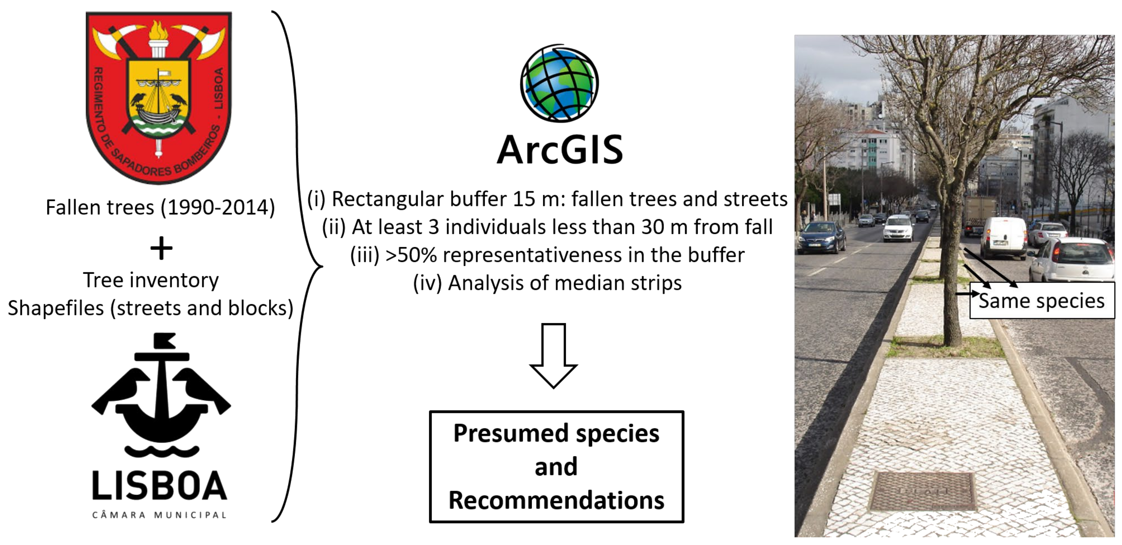
In this research, a Geographical Information System (GIS—ESRI ArcGIS 10.1) was used to evaluate the location of unknown species in proximity to other known species. The output data will be used in future risk analysis of windstorms in Lisbon. A flowchart of all the processes is shown in Figure 3.

2.3. Unknown Tree Species Determination by Proximity

The Lisbon Fire Department (LFD) and Zephyrus (Climate Change and Environmental Systems Research Group of CEG/IGOT ULisboa) provided a database with 3767 fallen tree cases recorded during the period from 1990 to 2014 (except for 2009, where data is absent), containing the geographic coordinates. This database has some limitations, such as: (i) for all records, the time information refers to the moment when LFD answered the call, not the exact moment the tree fell, (ii) records do not encompass falls in parks and squares that did not affect public infrastructure; (iii) information about species, size, age (young or old trees), and phytosanitary conditions were not systematically collected by LFD; and (iv) many cases may have been recorded hurriedly due to the need for urgency, which can influence the data’s reliability. Furthermore, another limitation of the study is the size of the streets and sidewalks, which vary according to the particularities of each neighborhood, so the values adopted in this method were field estimates observed in the case of the city of Lisbon.
These 3767 unknown tree species were plotted in the GIS. The data were cross-referenced with structural vectors, such as blocks, roads, streets, and another layer, which represented the inventoried trees, containing 47,713 individuals of which 26,595 had known scientific names. In addition, the data were crossed with the wind speed parameter of 7 m s−1 found by [12], who observed that the majority of tree falls (based on the Gago Coutinho Meteorological station, located in Lisbon) occurred in a period within 12 h before the Fire Brigade receives the call, that is, considering a delay of up to 12 h between the tree fall and the call/record. Thus, because the database does not identify the name of the fallen tree, we developed a method to determine which trees are most vulnerable to fall based on their proximity to other known trees. Because most data consist only of geographic coordinates and the date/time of recorded calls, the identity of a fallen tree was hypothesized through a “proximity-based approach” (Figure 4), in which the identity of the species was based on the species that surrounded it. This new method consists of four criteria that must be fulfilled in order for a presumption to be considered positive. This method is a feasible one for tree identification because of the way the tree lines are arranged on the streets.
Those tree species chosen for planting on Lisbon streets are subject to fashion cycles and are chosen by the city’s tree manager. Sophora japonica (1929), Populus spp. (1939), and Tilia spp. (1981 to 2003), for example, are the species that have been preferred by the tree manager, with Celtis australis being the most abundantly planted species since 1929. As a result, Lisbon’s streets contain large patches of the same species of trees [9]. Figure 5 shows a typical street planting scheme, where each dot represents a different species. Though not a rule, often only one species of tree is planted on each street to simplify the management requirements. This figure also indicates that a fallen tree (triangular dot) is presumed to be Fraxinus angustifolia Vahl (circles) because it meets the previously established identification criteria.

3. Results

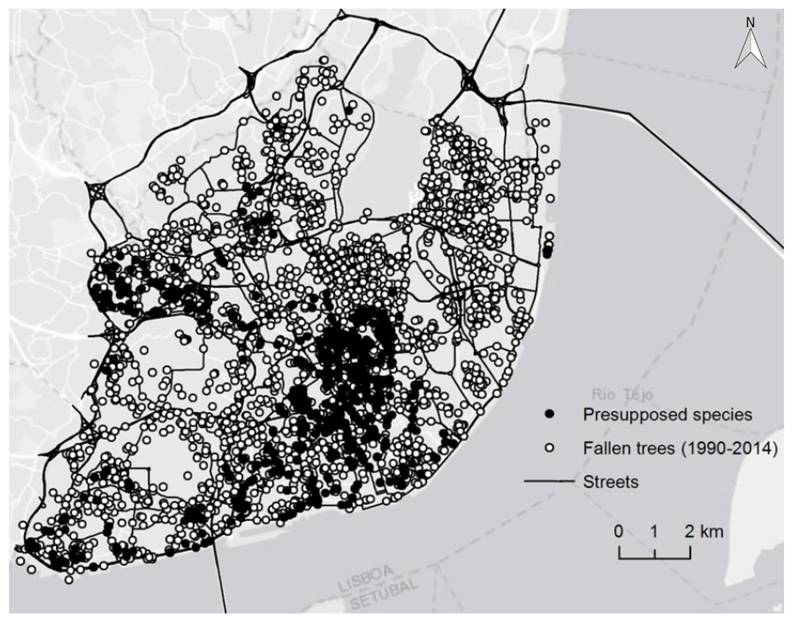
Based on the established criteria for tree identification, we were able to update the occurrence database (3767 cases) using the “proximity-based approach.” This allowed us to identify 736 cases, belonging to 43 different species, representing 19.5% of all occurrences in the analyzed period (Figure 6).
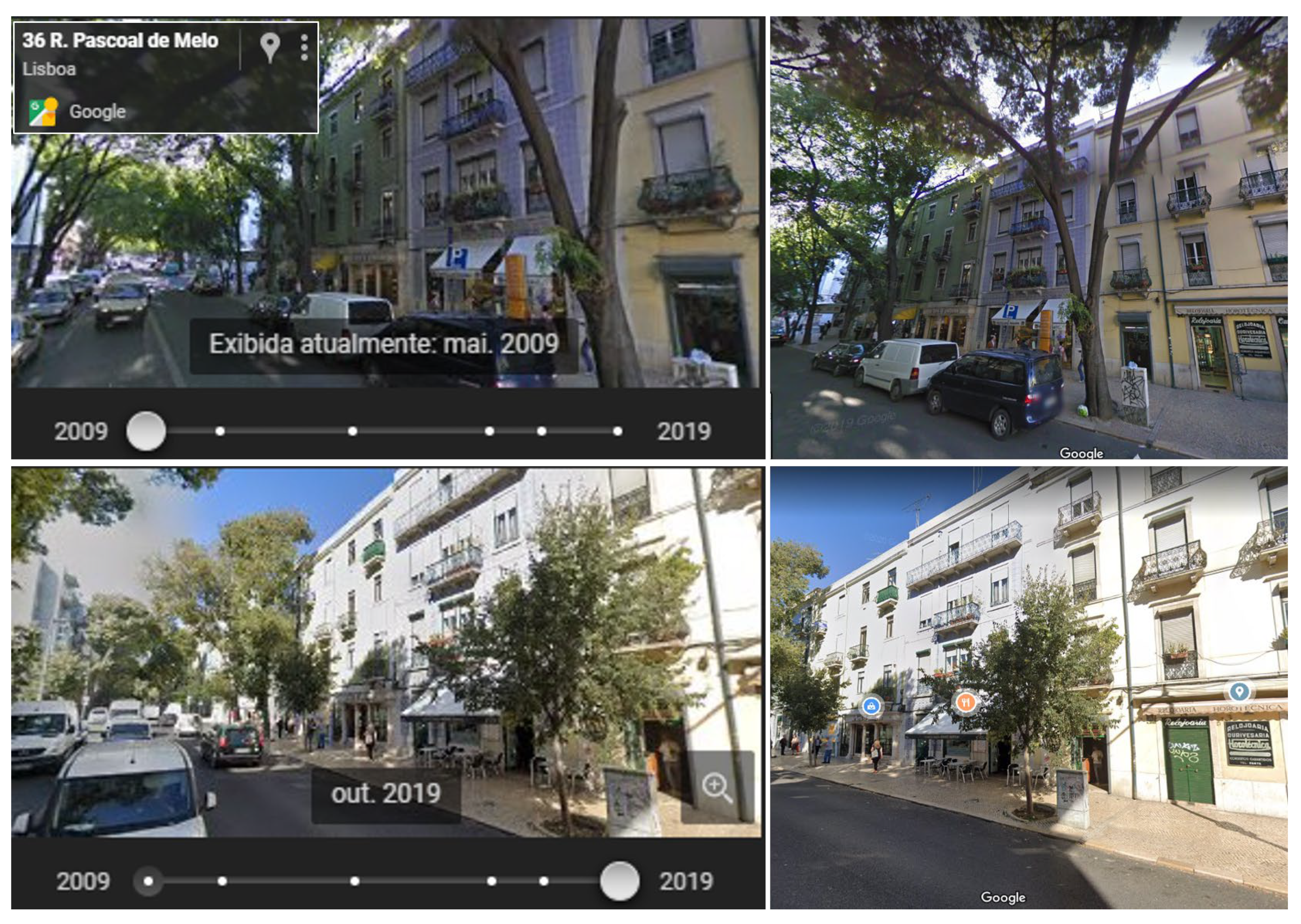
The real proof of the methodology proposed here consisted of empirical evidence through the analysis and comparison of past images from Google Street View of Lisbon. The oldest images corresponded to 2009, the oldest available for the city of Lisbon, while the most recent were from 2018 or 2019, depending on the street. In the illustrated example (Figure 7), two trees fell on 36 R. Pascoal de Melo, one in 2010 and the other in 2011. This is a street full of Celtis australis on both sides. Thus, applying the proximity-based approach, we presumed that there were two Celtis australis fall events. When taking the real proof, we realized that the image from 2009 showed that it was, in fact, this species, since such individuals no longer appeared in the most recent image from 2019. The real proof was carried out randomly in 5% of all presumed individuals (736 total cases), obtaining certainty in all cases. In addition, we noted that the most common replacement occurred around the Lisbon City Hall, where the fall was replaced by the same fallen species; however, this is not a rule, because we observed a few cases in which the substitution did not take into account the theme of the street, as in the 18 Av. Guerra Junqueiro (neighborhood Areeiro), in which eleven Fraxinus angustifolia fell and all were exchanged for Liquidambar styraciflua.
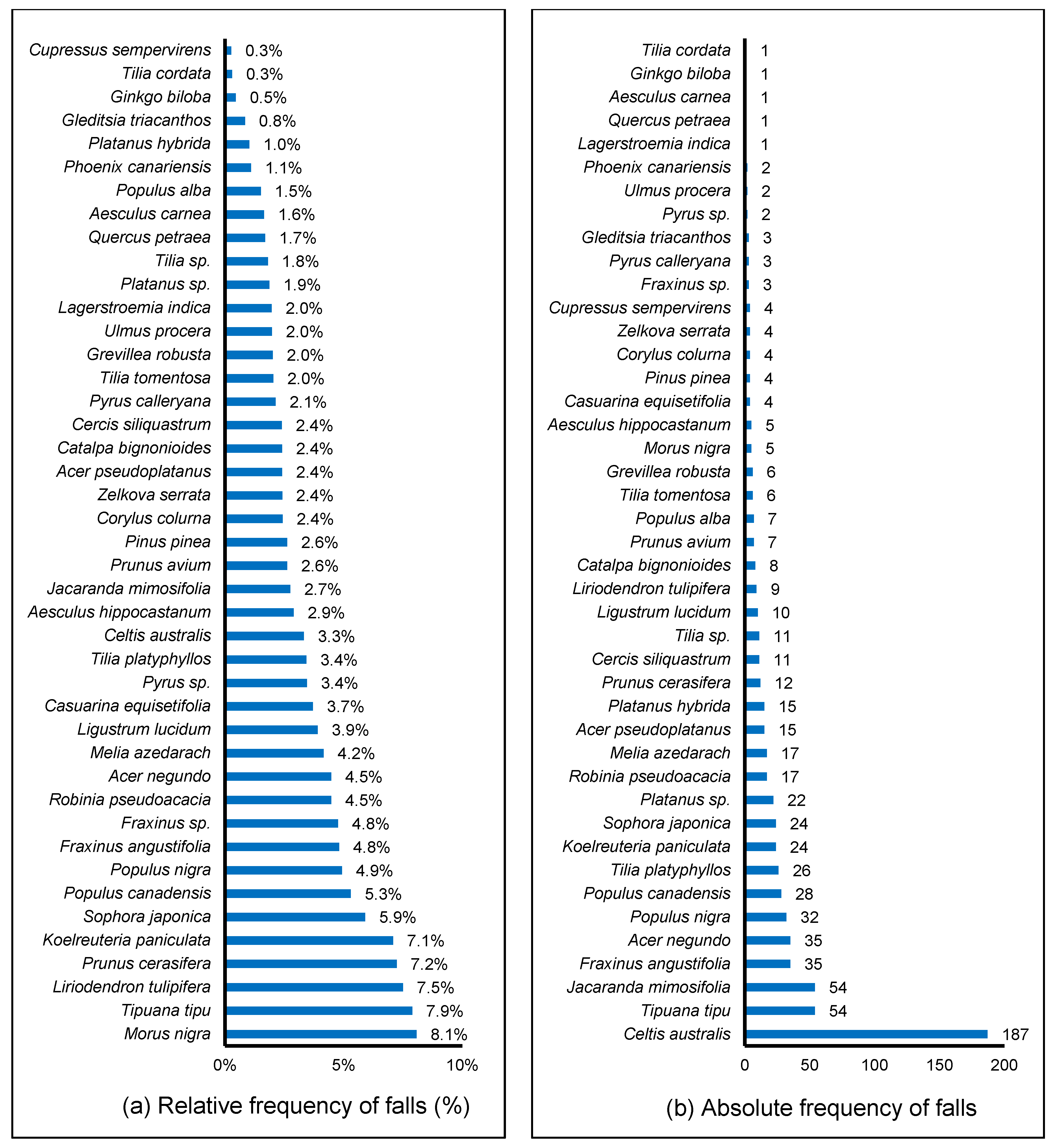
The relative frequency and absolute number of presumed fallen trees (Figure 8) were compared to the presumed trees within the currently known inventoried species. A minimum number of individual trees from those registered in the inventory (50) were used to guarantee species representativeness. The top eight (the highest relative frequency of falls) represented more than 49% of all trees identified and was composed of M. nigra L., Tipuana tipu (Benth.) Kuntze, Liriodendron tulipifera L., Prunus cerasifera Ehrh, Koelreuteria paniculata Laxm., Sophopora japonica, and Populus canadensis. This scenario changes when the absolute number of falls is analyzed. Based on absolute number, Celtis australis, Tipuana tipu (Benth.), and Jacaranda mimosifolia, the most planted trees in Lisbon, fall most frequently.

4. Discussion

While many scientific articles study the benefits of urban forests [1,2,5,10], few explore which species are best for planting on sidewalks. This demands further investigation. While not all arboriculture technical manuals provide a list of desirable species, they do identify which species should not be planted due to undesirable characteristics, such as the presence of thorns on the trunk, toxicity of leaves or fruits, vigorous roots, large fruits, and invasive behavior. None of them, however, consider the vulnerability of the tree to falling. Some recommend avoiding low-resistance species, but they do not give examples of these species because the literature on this topic is scarce. Hence, the choice of which tree is planted is often based on the information from and experience of the managers. While this method of selection should not be abandoned, it should be complemented with studies such as those highlighted in this article. France, Portugal, Sweden, the Netherlands, and Slovakia are some European countries that have analyzed the behavior of tree species in the urban environment and considered social, cultural, and economic factors combined with the restrictions of each location. According to [20], in France, Ref. [21] evaluated more than 20 species, while Ref. [22], in Portugal, tested more than 180 species. The researchers took advantage of Expo ‘98 (Lisbon World Exposition) to plant and evaluate tree survivability under demanding soil conditions. Sweden [23] and The Netherlands [24] are conducting progeny evaluations of seed stands and, consequently, a visual analysis of desired phenotypes. However, it is worth noting that maintaining genetic diversity in the tree population is very important because the absence of diversity increases their vulnerability to pests and disease.
In the same line, because visual analysis is the main technique used by managers to assess the risk of falling in urban trees, Ref. [25] analyzed the efficiency of this technique after the impact of Hurricane Matthew in 2016. It became a tropical storm with winds of 85 km h−1 (24 m s−1) when it reached the study area, toppling more than two thousand trees. They concluded that there was a high degree of accuracy for predicting fallings in those trees that had imminent failures. However, fallings in trees with medium and low risks of failure also occurs, but is more difficult to predict. The main reasons for falls were decayed branches, overextended branches, decayed trunks, deep planting, and twig diebacks.
It was observed that 57.7% of all the trees that fell occurred when the wind exceeded 7 m s−1 in the period up to 12 h before the fall was recorded by Lisbon Fire Department, a parameter set by [12], representing more than half of the falls, which highlights the importance of climate monitoring for the effective management of urban trees. There was a higher concentration of occurrences around Lisbon’s downtown area (Figure 2 and Figure 6), especially in the main traffic axis and on streets with more trees. Through the proximity-based approach, we were able to highlight the most vulnerable species: Morus nigra L., Tipuana tipu (Benth.) Kuntze, Liriodendron tulipifera L., Prunus cerasifera Ehrh, and Koelreuteria paniculata Laxm. (Figure 8). These species showed the worst resistance for the purposes of urban arborization, corroborating other results [22]. In their work, they developed a ranking of species adaptability in Lisbon, ranging from 1 (poor adaptation) to 4 (good adaptation) and found similar results: Tipuana tipu (Benth.) Kuntze and Prunus cerasifera Ehrh. have poor adaptation to urban conditions in Lisbon (receiving 1 on the rank), followed by Koelreuteria paniculata Laxm. (rank = 2), while Morus nigra L. (rank = 3) was relatively better adapted to the same conditions.
Prunus cerasifera Ehrh and Koelreuteria paniculata Laxm. had poor adaptation scores, while, by contrast, Tipuana tipu (Benth.) Kuntze had a good score [26]. This contradiction in the results of Tipuana individuals may be explained because Andresen evaluated the trees when they were still young, while [22] analysis occurred 16 years later. In addition, it is important to note that in Tipuana tipu, individuals with a DBH (diameter at breast height) larger than 60 cm may present internal trunk biodeterioration by fungi and/or subterranean termites, requiring deeper internal analysis techniques to avoid falls [27]. Fragility was also found in this species in a case study conducted in Piracicaba (Brazil). In general, they found a high correlation of tree falls with urbanization, that is, highly dense areas, such as city centers, where stressful conditions for tree development, compacted soil, and root cuttings/damages directly affected their stability and resilience [28]. In our investigation, Tipuana tipu appeared in both cases (relative and absolute cases) and we verified that this species could be considered vulnerable to falling when fully grown, requiring constant phytosanitary evaluation. Nevertheless, Tipuana has a high ecosystem services potential given its large dimensions when mature and its environmental and cultural importance to many cities. Likewise, the planting of fast-growing species should be avoided in areas of strong winds, such as Robinia spp. L. and Populus spp. L. [29], due to its natural susceptibility to breaking and falling under such conditions.
In brief, Morus nigra L., Tipuana tipu (Benth.) Kuntze, Liriodendron tulipifera L., Prunus cerasifera Ehrh., and Koelreuteria paniculata Laxm. were the species most vulnerable to falls, therefore requiring more detailed attention to the surrounding conditions by urban planners. Additionally, in the management of urban trees, the 3-30-300 rule [30] could be considered so that neighborhoods are greener, healthier, and more resilient, i.e., at least three trees from your window, 30% tree cover, and 300 m to nearest park. Finally, we recommend that Lisbon City Hall reinforces the team of Fire Department specialists with a forest engineer to enhance the standardization of data acquisition methodologies. This would aid in providing reliable fall records for future research as well as improving the management of Lisbon’s urban trees. Complementary research in other cities regarding the cause of trees to fall, such as street design, climatic conditions, diseases, natural decay, root problems, and other phytosanitary problems, is fundamental because of the scarcity of information on this topic and the fact that it is of great importance to improving the quality of life in cities.

Author Contributions

Conceptualization, F.H.M. and A.M.S.L.; methodology, F.H.M., E.L.T.C. and A.M.S.L.; software, F.H.M., E.L.T.C. and A.M.S.L.; validation, F.H.M. and A.M.S.L.; formal analysis, F.H.M., E.L.T.C. and A.M.S.L.; investigation, F.H.M. and A.M.S.L.; resources, F.H.M. and A.M.S.L.; data curation, F.H.M., E.L.T.C. and A.M.S.L.; writing—original draft preparation, F.H.M.; writing—review and editing, F.C.d.S.P., E.L.T.C. and A.M.S.L.; visualization, F.H.M.; supervision, A.M.S.L.; project administration, F.H.M. and A.M.S.L.; funding acquisition, F.H.M. and A.M.S.L. All authors have read and agreed to the published version of the manuscript.

Funding

This research was funded by University of São Paulo, grant number 12.1.26531.01.5.

Data Availability Statement

Dataset available on request from the authors.

Acknowledgments

We would like to thank the Demóstenes Ferreira da Silva Filho (USP/ESALQ) for the contact with University of Lisbon, Zephyrus (Climate Change and Environmental Systems Research Group of CEG/University of Lisbon) for the advice and study tools, and the Fire Department of Lisbon for fallen down trees database.

Conflicts of Interest

The authors declare no conflicts of interest. The funders had no role in the design of the study; in the collection, analyses, or interpretation of data; in the writing of the manuscript; or in the decision to publish the results.

References

  1. McPherson, G.; Simpson, J.R.; Peper, P.J.; Maco, S.E.; Xiao, Q. Municipal forest benefits and costs in five US cities. J. For. 2005, 103, 411–416. [Google Scholar] [CrossRef]
  2. Burden, D. Urban Street Trees: 22 Benefits Specific Applications; Glatting Jackson and Walkable Communities Inc.: Orlando, FL, USA, 2006; pp. 1–21. [Google Scholar]
  3. Andrade, H.; Vieira, R. A climatic study of an urban green space: The Gulbenkian Park in Lisbon (Portugal). Finisterra 2007, 42, 27–46. [Google Scholar] [CrossRef]
  4. Goddard, M.A.; Dougill, A.J.; Benton, T.G. Scaling up from gardens: Biodiversity conservation in urban environments. Trends Ecol. Evol. 2010, 25, 90–98. [Google Scholar] [CrossRef] [PubMed]
  5. Roy, S.; Byrne, J.; Pickering, C. A systematic quantitative review of urban tree benefits, costs, and assessment methods across cities in different climatic zones. Urban. For. Urban. Green. 2012, 11, 351–363. [Google Scholar] [CrossRef]
  6. Reis, C.; Lopes, A. Evaluating the Cooling Potential of Urban Green Spaces to Tackle Urban Climate Change in Lisbon. Sustainability 2019, 11, 2480. [Google Scholar] [CrossRef]
  7. Santamour Júnior, F.S. Trees for urban planting: Diversity uniformity, and common sense. In Proceedings of the VII Metropolitan Tree Improvement Alliance, Lisle, IL, USA, 11 June 1990. [Google Scholar]
  8. Lisbon City Hall. Vinte e Cinco Árvores de Lisboa; CML, DMAU, DAEV: Lisbon, Potugal, 2019; pp. 1–32. [Google Scholar]
  9. Soares, A.L.; Castel-Branco, C. As árvores da cidade de Lisboa. In Floresta e Sociedade: Uma História em Comum; Silva, J.S., Ed.; Flad: Lisbon, Portugal, 2007; pp. 289–334. [Google Scholar]
  10. Soares, A.L.; Rego, F.C.; McPherson, E.G.; Simpson, J.R.; Peper, P.J.; Xiao, Q. Benefits and costs of street trees in Lisbon, Portugal. Urban. For. Urban. Green. 2011, 10, 69–78. [Google Scholar] [CrossRef]
  11. Lopes, A.; Mendes, F.; Correia, E. Street trees vulnerability to strong wind events in Lisbon: Meteorological and phytosanitary assessment to mitigate urban hazards. In Proceedings of the International Conference on Urban Risks, Lisbon, Portugal, 30 June 2016. [Google Scholar]
  12. Lopes, A.; Oliveira, S.; Fragoso, M.; Andrade, J.; Pedro, P. Wind risk assessment in urban environments: The case of falling trees during windstorm events in Lisbon. In Bioclimatology and Natural Hazards; Střelcová, K., Mátyás, C., Kleidon, A., Lapin, M., Matejka, F., Blaženec, M., Škvarenina, J., Holécy, J., Eds.; Springer: Dordrecht, The Netherlands, 2009; pp. 55–74. [Google Scholar]
  13. Ribeiro, P.; Lopes, A. Modelação do risco de queda de árvores sobre as viaturas devido a ventos fortes em Lisboa. In Proceedings of the VIII Congresso da Geografia Portuguesa, Lisbon, Portugal, 29 October 2011. [Google Scholar]
  14. Mattheck, C.; Breloer, H. The Body Language of Trees: A Handbook for Failure Analysis; The Stationery Office: London, UK, 1997; pp. 1–320. [Google Scholar]
  15. Albers, J.S.; Pokorny, J.D.; Johnson, G.R. How to detect and assess hazardous defects in trees. In Urban Tree Risk Management: A Community Guide to Program Design and Implementation; Pokorny, J.D., Ed.; USDA Forest Service: Saint Paul, MN, USA, 2003; pp. 41–116. [Google Scholar]
  16. Lopes, A.; Oliveira, S.; Fragoso, M. Vento forte e queda de árvores em Lisboa: Avaliação e primeiros resultados. In Estudos sobre Cidades e Alterações Climáticas; Alcoforado, M.J., Andrade, H., Fragoso, M., Lopes, A., Lombardo, M., Matzarakis, A., Oliveira, S., Eds.; Centro de Estudos Geográficos: Lisbon, Portugal, 2008; pp. 71–91. [Google Scholar]
  17. Hou, G.; Chen, S. Probabilistic modeling of disrupted infrastructures due to fallen trees subjected to extreme winds in urban community. Nat. Hazards 2020, 102, 1323–1350. [Google Scholar] [CrossRef]
  18. National Institute of Statistics (INE). Available online: http://www.cm-lisboa.pt/municipio/demografia (accessed on 27 November 2020).
  19. IPMA. Available online: http://www.ipma.pt/bin/file.data/climate-normal/cn_71-00_LISBOA_GAGO_COUTINHO.pdf (accessed on 18 December 2020).
  20. Sæbø, A.; Borzan, Z.; Ducatillion, C.; Hatzistathis, A.; Lagerström, T.; Supuka, J.; García-Valdecantos, J.L.; Rego, F.; Van Slycken, J. The selection of plant materials for street trees, park trees and urban woodland. In Urban Forests and Trees; Konijnendijk, C., Nilsson, K., Randrup, T., Schipperijn, J., Eds.; Springer: Berlin/Heidelberg, Germany, 2005; pp. 257–280. [Google Scholar]
  21. Ducatillion, C.; Dubois, E. Diversification des plantes ornementales méditerranéennes: Estimation des besoins qualitatifs des villes en arbres et arbustes. In La Plante Dans la Ville; Rivière, L.M., Ed.; INRA: Angers, France, 1997; pp. 139–149. [Google Scholar]
  22. Rego, F.C.; Castel-Branco, C. A escolha das espécies: Da lista referencial às plantações experimentais. In O Livro Verde; Castel-Branco, C., Rego, F.C., Eds.; Expo’98: Lisbon, Portugal, 1998; pp. 71–85. [Google Scholar]
  23. Lagerström, T.; Eriksson, G. Improvement of trees and shrubs by phenotypic selection for landscaping in urban and rural areas—A Swedish example. For. Landsc. Res. 1996, 1, 349–366. [Google Scholar]
  24. De Vries, S.M.G.; Van Dam, B.C. Selection programme of oak in The Netherlands. In Diversity and Adaptation in Oak Species; Steiner, K.C., Ed.; University Park: Philadelphia, PA, USA, 1998; pp. 201–208. [Google Scholar]
  25. Koeser, A.K.; Smiley, E.T.; Hauer, R.J.; Kane, B.; Klein, R.W.; Landry, S.M.; Sherwood, M. Can professionals gauge Likelihood of failure?—Insights from tropical storm Matthew. Urban. For. Urban. Green. 2020, 52, 126701. [Google Scholar] [CrossRef]
  26. Andresen, M.T.L.M.B. Árvores de Arruamento de Lisboa, Contribuição Para a sua Classificação. Undergraduation, Landscape Architecture. Bachelor Thesis, Instituto Superior de Agronomia, Universidade Técnica de Lisboa, Lisbon, Portugal, 1982. [Google Scholar]
  27. Brazolin, S. Biodeterioração, Anatomia do Lenho e Análise de Risco de Queda de Árvores de Tipuana, Tipuana Tipu (Benth.) O. Kuntze, nos Passeios Públicos da Cidade de São Paulo, SP. Ph.D. Thesis, Forest Resources, Escola Superior de Agricultura “Luiz de Queiroz”, Universidade de São Paulo, São Paulo, Brazil, 2009. [Google Scholar]
  28. Mendes, F.H.; Polizel, J.L.; Silva Filho, D.F. O efeito do vento nas quedas de árvores em Piracicaba/SP. Ciên. Nat. 2016, 38, 1523–1535. [Google Scholar] [CrossRef]
  29. Mailliet, L.; Bourgery, C. L’ Arboriculture Urbaine; Institut pour le Développement Forestier: Crécy-Couvé, France, 1993; pp. 1–318. [Google Scholar]
  30. Konijnendijk, C.C. Evidence-based guidelines for greener, healthier, more resilient neighbourhoods: Introducing the 3-30-300 rule. J. For. Res. 2023, 34, 821–830. [Google Scholar] [CrossRef] [PubMed]
Figure 1. Occurrences of tree and branch falls from 1990–2014. Source: [11].
Land 13 00708 g001
Figure 2. Patterns of tree and branch falls between 1990 and 2014. Source: Adapted from [11].
Land 13 00708 g002
Figure 3. Flowchart regarding all processes carried out in this research.
Land 13 00708 g003
Figure 4. Criteria for species presumption for Lisbon’s fallen trees database: (i) Trees must be within 15 m of the street axis; (ii) At least three individuals within 30 m of the fallen tree must belong to the same species; (iii) The surrounding trees must represent more than 50% of all trees on the studied street; and (iv) A visual identification must be performed using trees on street and avenue medians.
Land 13 00708 g004
Figure 5. Example of tree planting scheme in Lisbon. By completing the criteria, the fallen tree (triangle) can be presumed to be Fraxinus angustifolia Vahl (circles).
Land 13 00708 g005
Figure 6. Map with 3767 fallen trees during the period from 1990 to 2014 in Lisbon. Circle dots correspond to all tree falls recorded in the period, while black dots are species with presumed identities based on the proximity approach.
Land 13 00708 g006
Figure 7. Real proof of the efficiency of the proximity-based approach, analyzing the fall of two Celtis australis through past (2009) and recent (2019) Google Street View images, in which the Lisbon City Hall fallen trees were replaced by two other new individuals of the same species.
Land 13 00708 g007
Figure 8. Fallen trees in Lisbon in the period from 1990 to 2014, considering species with at least 50 individuals registered in the inventory, to guarantee its representativeness: (a) Relative frequency in percentage and (b) Frequency in absolute number.
Land 13 00708 g008
Disclaimer/Publisher’s Note: The statements, opinions and data contained in all publications are solely those of the individual author(s) and contributor(s) and not of MDPI and/or the editor(s). MDPI and/or the editor(s) disclaim responsibility for any injury to people or property resulting from any ideas, methods, instructions or products referred to in the content.