Abstract
Rural industrialisation in China, which has historically been restricted by urban–rural dual development policies, has been largely encouraged since the Rural Revitalisation Strategy released in 2018. Industrialisation has deeply influenced socio-spatial evolution by providing job opportunities and promoting the construction of infrastructure and public services, accelerating the two-way flow of urban–rural factors in rural areas. However, this may lead to social and spatial issues, such as social inequalities and unsuitable living conditions, to some extent. This research aims to investigate how the socio-spatial evolution of rural areas was influenced by rural industrialisation and the two-way flow of urban–rural factors. The cherry planting industry and an active “industrial centre”, Yuezhuang Village, in Linqu County, Shandong Province, China, were selected for the empirical study. This research analysed the evolution of the cherry planting industry, the formulation of rural social networks, and the spatial adaptation of the two using mixed qualitative and quantitative methods, followed by a discussion on the current rural planning policies in China. The results show that the cherry industrial chain largely extended the planting areas, and the categories of land use generally increased in Yuezhuang Village over the 30 years studied. The average output value per mu (mu is unit of area measurement used in China, where it is officially standardised. It corresponds to 1/15 of a hectare, or about 666.67 m2). In 2021 was 25 times larger than that in 1996. The population involved in industrial activities increased to over 5000 people countrywide from the initial 17 households. The results also show that urban–rural factors, such as capital, population, techniques, and information, rapidly accelerated in the annual peak season of the cherry industry. This research indicates that small-scale, characteristic, and traditional agriculture could become one of the main driving forces in urban–rural integration and may contribute to sustainable and inclusive rural communities and urban–rural partnerships. This provides the theoretical mechanism of socio-spatial interaction in rural industrialisation in China based on the empirical case study.
1. Introduction
Improving industrial development has been widely recognised as a priority for strengthening urban–rural linkages, which contributes to sustainable and inclusive economic growth and social equality [1,2]. Similar to strategies proposed in the 2030 Agenda for Sustainable Development (SDGs), the Industrial Revitalisation Strategy was released as the priority in the Rural Revitalisation Strategy in 2018 in China [3], followed by the Urban–Rural Integration Strategy proposed in 2019 [4]—which encourages the two-way flow of urban–rural factors to achieve functional complementarity and structural coordinated development towards a sustainable future [5]. In fact, from 2004 onward for 18 years, China promulgated policies that focused on rural development in terms of the promotion of agriculture, the countryside, and farmers [6], and among them, the development of agriculture is of particular importance. Furthermore, as part of the development of proper secondary and tertiary industries, such as tourism, cultural and creative, handicraft [7,8] was considered an effective strategy to promote the two-way flow of urban–rural factors, such as capital, population, techniques, and information [9]. However, due to rural land restrictions, insufficient skilled labour, and a lack of organisation and management in the production process, rural industries have been trapped in a dilemma for a long period [10].
Rural industrialisation in China has been largely influenced by urban–rural dual development policies, mainly land-use policies, household registration policies, and industrial policies. Because land-use policies restricted the majority of rural land use as homesteads owned by farmers and arable land to ensure national food security [11,12,13], rural construction land for the development of new industries was strongly limited, leading to less investment and fewer job opportunities in rural areas [14]. However, household registration policies changed in 2000 to allow the rural population to migrate to cities, leaving behind large numbers of older people and children [15], which meant a lack of labour in rural areas. In contrast, urban areas had adequate construction land controlled by the land market, which attracted investments for various large-scale industries [14,16]. The development of urban industries further attracted urban and rural populations and promoted the construction of urban infrastructures and public services [17]. Additionally, due to the lack of scale effects and environmentally unfriendly production [18], rural industries declined during the late 1990s. Although small industries related to agriculture were still developing, favourable policies that aimed to encourage the large-scale development of rural industries were released after 2011 [9]. These policies showed that rural industrialisation in China experienced significant challenges.
The influences of the rural industrialisation process have been widely discussed over recent years, especially regarding the socio-spatial evolution of rural areas. After the Rural Revitalisation Strategy was released in 2018, the increasing two-way flow of urban–rural factors in the rapid urbanisation process promoted rural industrialisation [19]. With the improvement in transportation and digital infrastructure in both urban and rural areas, spatial distance was no longer a barrier to seeking high-quality employment opportunities and living conditions [20] in this new era in China. With issues such as traffic congestion, high housing prices, and insufficient public activity space in urban areas [21], rural areas became more attractive to people looking for spaces to live and work due to the good natural environment and distinctive production resources [22]. However, the development of rural industries and appropriate living conditions in rural areas is unbalanced [23]. The pursuit of maximising the benefits of rural industrial development has led to a decline in the quality of the rural living environment, which is characterised in different ways and has led to an “asymmetric” structure in the socio-economic development of these regions [24]. Aiming to alleviate such imbalances, some researchers proposed that socio-spatial development needs to suit the change in rural productivity and production relations [25,26]; that is, the demands of industrial activities and social networks need to be seriously considered in rural planning, construction, and implementation.
The above discussion regarding the background of rural industrialisation in China reveals that there may be tight connections between industrial development and socio-spatial evolution in rural areas. Thus, this research aims to better understand the relationship between these two factors and their influences on urban–rural integration. The key research question is as follows: How has the socio-spatial evolution of rural areas been influenced by rural industrialisation and the two-way flow of urban–rural factors? This research involves the study of the planting industry, which is one of the most characteristic, representative, and embedded industries in rural areas. Yuezhuang Village, Linqu County, Shandong Province, China, was chosen as the study area due to its importance in the cherry planting industry. Linqu County is one of the four main greenhouse cherry cultivation areas in China. A review of the existing literature on rural industrialisation and its influences on urban and rural areas and the socio-spatial dialectical perspective is presented in Section 2. The research setting and methods are illustrated in Section 3. The evolution of the cherry planting industry, the formulation of rural social networks, and the spatial adaptation of the two are discussed in Section 4, resulting in the identification of the mechanism of socio-spatial evolution driven by industrial development. The current rural planning policies and planning inspiration in China are discussed in Section 5, and Section 6 concludes the paper.
2. Literature Review
2.1. Rural Industrialisation and Its Influences on Urban and Rural Areas
The research on rural industrialisation usually focused on urban–rural socio-economic development. Amjad mentioned that “the aim of rural industrialisation has been to promote the production of commodities based on agricultural output” [27], showing the significance of rural industrialisation on poverty reduction, economic growth, and better living conditions towards sustainability [28]. Many scholars analysed the relationship between rural industrialisation and floating populations, job opportunities, and economic increases using statistical data and questionnaires [27,28,29], indicating the urban–rural socio-economic linkage and the flow of factors in the urbanisation process [30]. Scholars discussed the relationship between rural industrialization and rural enterprises, focusing on employment opportunities and financial support for farmers in China [31,32]. Scholars also studied the relationship between small and medium-sized enterprises (SMEs) and rural development, analysed the characteristics of rural firms compared to their counterparts in urban England, and contributed to the discussion on policies [33]. However, most of the past research on rural industrialisation usually focused on social-economic development, but the change of spatial constructions in rural areas were not deeply analysed. Although Desai has mentioned that the poor infrastructural facilities in rural segments was one of the factors holding back rural industrialisation in India [34], the relationship between the socio-economic development and spatial constructions were not discussed due to a lack of data on rural areas, which showed the inadequate understanding of the flow of urban–rural factors in the rural industrialization process.
With the upgrading of urban and rural transportation, mobile Internet, and other infrastructure, rural industrialisation is deeply influenced by the flow of urban–rural factors, and production and living spaces present new features and trends in rural China. New forms of business such as rural cloud economy, agricultural headquarters, homestay economy, and customized agriculture are constantly emerging, and new rural settlements such as e-commerce villages, live streaming villages, and artist villages are emerging one after another [35]. The return of “new villagers”, urban and rural part-time workers, and returned entrepreneurs also promotes the continuous evolution of the social structure of some villages [36]. The two-way flow of urban–rural factors promotes the integration and co-construction of urban and rural social networks and spaces. Therefore, it is necessary to explore the socio-spatial interaction from the perspective of the two-way flow of urban–rural factors when studying rural industrialisation. The research on mechanisms of this interaction needs to be revealed in the current period of urban–rural integration in China.
2.2. The Flow of Urban–Rural Factors from the Socio-Spatial Dialectic Perspective
The two-way flow of urban–rural factors in rapid urbanisation poses new challenges for understanding urban–rural relations, which should be fully reconsidered in the research on rural revitalisation in the new era. Since the 1990s, scholars have reflected on the definition of urban and rural areas based on new practical experiences of urban and rural areas in the process of globalization. They have identified the difficulty in grasping differences and connections between urban and rural areas from the perspective of binary development, and a new understanding of the co-evolution of urban and rural areas has been widely discussed and supported [37,38]. China has experienced an extreme “time–space compression” [39] in the rapid urbanisation process. The traditional understanding of the “dual” development pattern of urban and rural areas has been replaced by the “flow space” network pattern [40] in this process in China. The flow of urban–rural factors has led to deeply interconnected and interactive urban–rural areas as a whole within a temporal and spatial range [41]; however, this process also led to inevitable urban–rural socio-economic inequalities. Compared to rural areas, urban areas have more advantages in attracting urban–rural factors, such as labour, investment and information, resulting in an under-developed rural built environment included inadequate construction of infrastructures and hollowed-out villages due to declined rural populations [23]. In the period of urban–rural integration, diverse and multidimensional spatial characteristics in rural areas [42] need to be studied to improve the understanding of urban–rural relations [41,43].
The socio-spatial dialectic perspective explores spatial organisation and meaning construction based on factor behaviour and its interrelationships, providing a comprehensive way to understand rural industrialisation during the period of urban–rural integration. The foundation of socio-spatial dialectics is the “production of space” theory proposed by Lefebvre, which demonstrates the logic of spatial production through the construction of the theoretical frameworks of “spatial practice” and “representation of space” [44]. It criticises the traditional “container” absolute spatial view and the classical Marxist theory that emphasises the connection between society and history, while neglecting the connotation of the connections among space, society, and history [45]. Soga proposed “socio-spatial dialectics” based on Lefebvre and Harvey’s construction of the theory of the “production of space”, expressing “spatial organization as a social product” through “spatiality”. The organisation and significance of space are the products of the correlations and interactions among various factors in society [46]. Behaviour of space users endow space value and strive to meet their own needs by influencing and transforming space as much as possible; at the same time, there is a gradual adaptation to the spatial environment and other surrounding entities, forming an interaction between entities and space [47]. From the dialectical perspective of society, space, and time, the bidirectional continuous interaction between the behavioural subject and the surrounding specific space promoted the shareability of space [48] and the involvement of the behavioural subject. This perspective provides an epistemological basis for understanding spatial–behavioural interaction [49]. Compared with the research on individual behaviours in behavioural geography [50], behaviours of actors driven by rural industrialisation within a specific space promoted the shareability of space [48] and the involvement of the behavioural subject. This perspective provides an epistemological basis for understanding spatial–behavioural interaction [49]. Compared with the research on individual behaviours in behavioural geography [50], behaviours of actors driven by rural industrialisation within a specific spatial–temporal range has stronger certainty due to their consistent goals. spatial–temporal range has stronger certainty due to their consistent goals. Moreover, the projection characteristics of the factors’ interrelationships in space are more typical, which can better reveal the evolution mechanism of the rapid flow of urban–rural factors and spatial interactions in the urbanisation process in China.
3. Case Selection and Methods
3.1. Case Selection: Yuezhuang Village in Linqu County
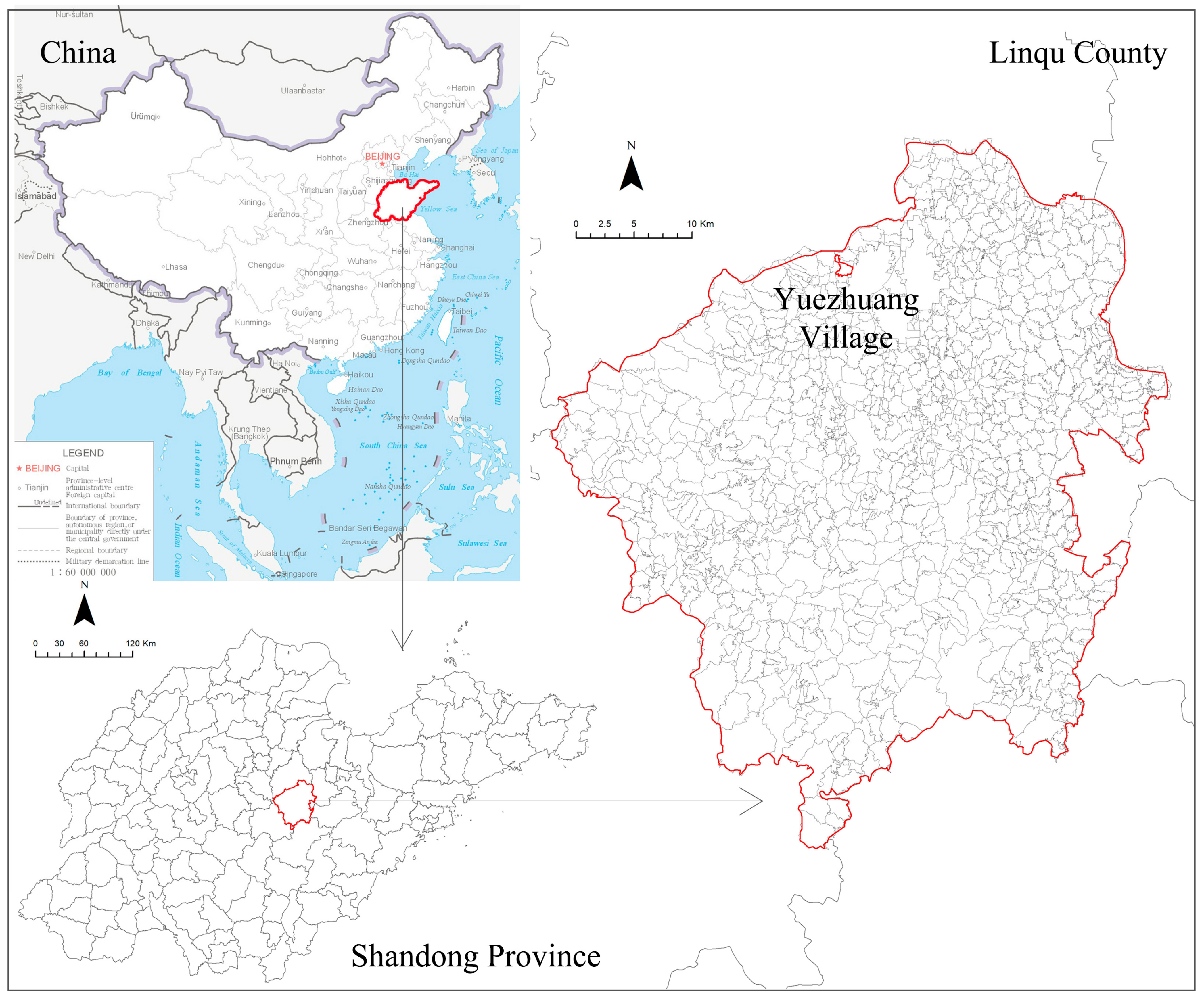
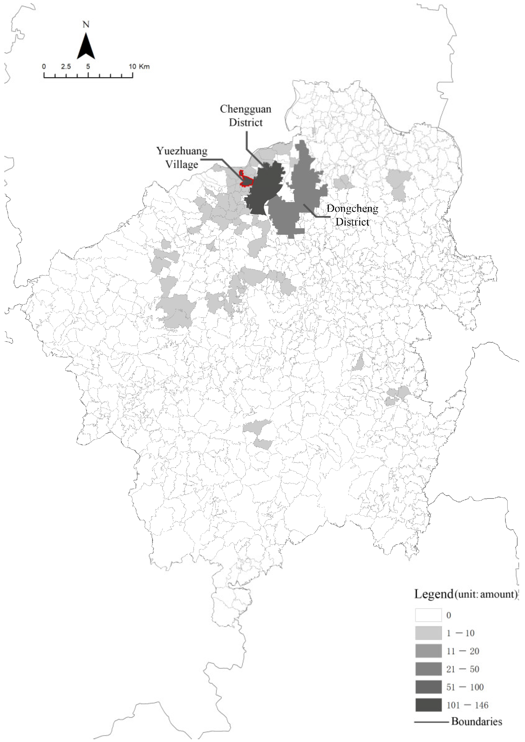
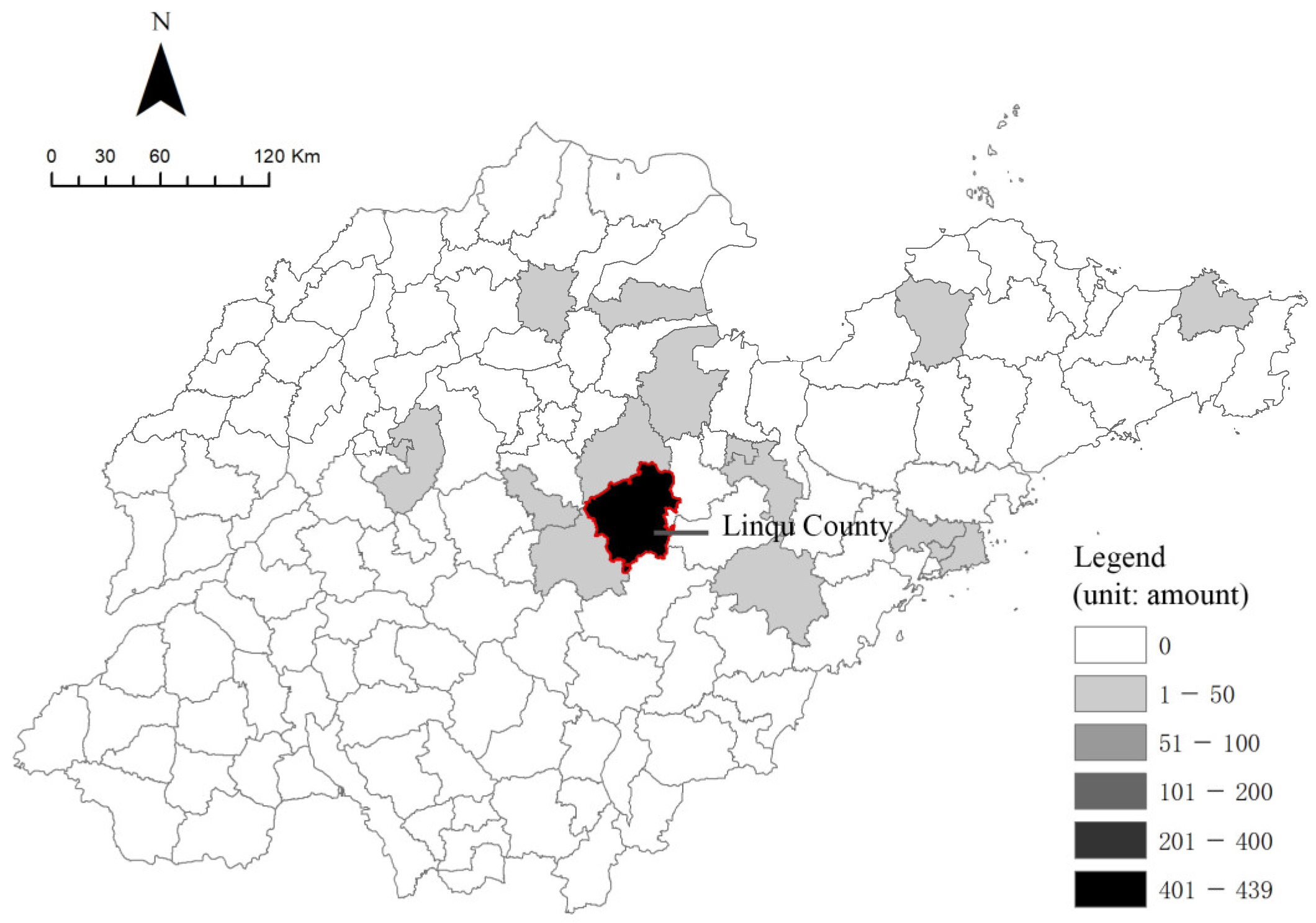
This research selected Yuezhuang Village and the county it belongs to, namely, Linqu County in Shandong Province, as the area for the empirical study. Linqu County is one of the four main greenhouse cherry cultivation areas in China, and Yuezhuang Village was one of the first areas to contain cherry planting test plots (in 1991). This village is one of the most active and famous centres of cherry industry activity in Linqu County according to multiple participatory observations and in-depth semi-structured interviews conducted from 2019 to 2023. Yuezhuang Village is a hamlet located at an urban–rural interface and is under the jurisdiction of Chengguan District in Linqu County, 1.5 km west of the county centre (Figure 1). The registered population of the village is approximately 1800 people (Mr. Li, in-depth interview, April 2023). The total area of the village is 1894 mu (1.26 km2), and orchards account for approximately 68%, according to the third national land resource survey carried out in 2019. The current cherry planting area accounts for about 54% of the land area of the village (Mr. Li, in-depth interview, April 2023). The cherry growing period in Yuezhuang Village runs from November to May of the following year, and the trading period (peak season) is from early March to the end of May. During the study period, data regarding the urban–rural factors (population, technology, capital, and information) were gathered not only for Yuezhuang Village but also for the urban–rural interfaces in Linqu County. The industrial activities in Yuezhuang Village have formed an active labour market and trading market, which have improved the construction of rural infrastructure and local public services.
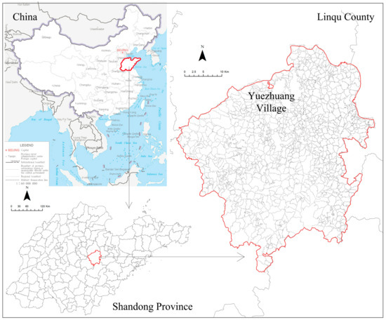
Figure 1.
Location of the case. Source: Authors’ own diagrams. The China map was obtained from the standard map service system. (http://211.159.153.75/browse.html?picId=%274o28b0625501ad13015501ad2bfc0291%27) accessed on 31 March 2024).
3.2. Data and Mixed Method Research
This research focused on the socio-spatial evolution in Yuezhuang Village driven by industrial planting activities in the peak and off-peak seasons as well as the flows of urban–rural factors related to such activities. Thus, the history of the planting industry and annual industrial activities were outlined first in this research. Furthermore, economic transformation (e.g., job opportunities and industrial output), social networks, and land-use changes driven by industrial development were identified as essential aspects of the research [33,51] and were taken as evidence for the industrial–socio-spatial interaction. This research also analysed the two-way flow of urban–rural factors in this interaction by identifying people’s mobility patterns in this process.
This study used people’s mobility patterns to illustrate the characteristics of the annual industrial activities and social networks they formed. Mobility patterns show the connection between an origin and destination, illustrating the flow of people during a specific period [52,53], which can be captured using location-based service (LBS) data [54,55]. This research utilised the LBS data from Linqu County for two whole months, namely, April (in the peak season) and September (the off-peak season) in 2019, which contained the anonymous and comparatively accurate real-time positions of individuals. These data were analysed using density-based spatial clustering of applications with the noise algorithm, which can effectively handle noise points and identify high-density areas as spatial clusters [56,57]. The identified clusters can be further filtered by excluding the frequencies of inactive real-time positions of anonymous IDs. In this research, a trajectory that occurred from 10:00 pm to 5:00 am the following day was defined as being within the residence of the ID, and a trajectory that occurred from 9:00 am to 4:00 pm was defined as being within the working place of the ID, according to the in-depth field investigations conducted in Yuezhuang Village. Using a comparative analysis of the spatial distribution of residences and working places in the peak and off-peak seasons in different spatial ranges, this research visualised the mobility patterns driven by annual industrial activities and revealed the social networks and their spatial connections within and outside of Yuezhuang Village.
This research also involved an archival study and in-depth field investigations, including participatory observations from 2019 to 2023, in-depth semi-structured interviews, and mapping. These methods were used to identify the evolution stages of the cherry planting industry, identify the industrial activities and socio-spatial interactions in the peak and off-peak seasons, verify the findings from the LBS data analysis, and directly and indirectly obtain evidence of the two-way flow of urban–rural factors in the socio-spatial evolution process.
Both qualitative and quantitative data were obtained in this research. Qualitative data were obtained from in-depth semi-structured interviews with 15 villagers and merchants who lived and worked in Yuezhuang Village in the peak and off-peak seasons between 2021 and 2023, including each category of actors involved in industrial activities. In addition, a group discussion with village representatives and local market managers was also conducted. The interviews with villagers were focused on the following: their roles in industrial activities; their attitudes to current land use and spatial functions in the village; their job opportunities and incomes; their knowledge of current land-use policies and rural industrial policies; major challenges they faced; and their concerns about the future development of the village, such as the changes in infrastructure and public services. The interviews with local market managers investigated the following: their attitudes to current land use and spatial functions in the village; their knowledge of current land-use policies and rural industrial policies; how they managed the transaction process in the peak season; how they built social networks with other urban–rural regions; the major challenges they faced; and their concerns about the future development of the village. The interviews were conducted with two planning professionals who had been embedded in local development for a long period (more than 4 years). Each interview with the villagers lasted for about half an hour, and the interview with local market managers lasted 3 h (audio recorded with the consent of the respondents). Additionally, archival studies of the formulation of the cherry industry in Linqu County, as presented in documents provided by the village committee, were also used.
The quantitative data in this research consisted of the LBS data and land-use data. The LBS data were collected from the trajectories of people living and travelling within the research area, namely, Linqu County, and were processed and visualised using SQL and GIS software 10.7. All data obtained were anonymised. The data regarding land use in Yuezhuang Village came from the second and third national land resource surveys carried out in 2009 and 2019 in China; the related diagrams presented in this research were created by the author according to the original data. This study strictly abided by academic ethics.
4. Analysis
4.1. Industrial Evolution: The Formation Stages and Annual Activities of the Cherry Industry
The evolution of the cherry industry in Yuezhuang Village can be basically divided into three stages. The urban–rural flows of industrial factors were initially formed in the first two periods and had begun to interact with the physical environment of the village, while the agglomeration of industrial factors accelerated the formation of social correlation networks and led to socio-spatial evolution in the third period.
The first stage was the initial period of the cherry industry and rural construction (1990–2000). “In 1991, Yuezhuang Village did not have any secondary industry, and the village committee had little money to develop the village” (Mr. Li, in-depth interview, April 2023). To improve the current situation of the low collective income and meagre per capita income in the village, the old village committee secretary introduced the cherry planting industry in Yuezhuang Village in 1992 through personal social relationships. The initial cherry planting area was 17 mu (0.011 km2) in 1992, and the average output value per mu was RMB 2000 in 1996, according to historical documents from the village committee. There were initially 17 households in Yuezhuang Village who tried to plant cherries from 1992 to 1993. Driven by rural talents, planters promoted the planting techniques, especially the technique of greenhouse cherry planting, and connected with fruit distributors outside Linqu County. By the end of 1998, the average output value per mu of cherry planting had risen to RMB 15,000 (Mr. Li, in-depth interview, August 2021). Meanwhile, new spatial planning of Yuezhuang Village began around 1990, which laid the foundation for homestead distribution, neighbourhood space allocation, and internal roads in the village. At this stage, the cherry planting industry was gradually becoming more accepted by the villagers due to its high profits compared with grain planting; however, the industrial factors had not been systematically organised.
The second stage was the spatial construction period driven by industrial activities (2000–2010). Benefiting from the greenhouse cherry planting technique, after 2000, the villagers in Yuezhuang Village prioritised this work. “By the end of 2000, 95% of the cultivated land had planted cherries (about 1000 mu, 0.667 km2), leading to the increasing demand for an extended industrial chain, including trading and transporting” (Mr. Li, in-depth interview, April 2023). Because cherries are not easy to store and have a short shelf life, the farmers needed to sell products to merchants in a short time to maximise their profits. Thus, the bottom-up organization of the cherry-trading process emerged and flourished after 2006 in Yuezhuang Village according to farmers’ knowledge of characters of cherry cultivation periods (Mr. Li, in-depth interview, April 2023). At this stage, urban–rural factors driven by the planting industry had begun to flow in and out of the village and even the county. However, the spatial construction of the village had not adapted in a timely manner to the new demand for trade, resulting in insufficient trading space and inadequate transportation infrastructure. To alleviate this problem, the village committee funded the Cherry Trading Centre in the northern ditch of the village in 2008, hardened the main trading road, and connected the roads inside and outside the village in 2010 to improve the physical environment.
The third stage was the socio-spatial evolution of Yuezhuang Village, which was driven by the agglomeration of industrial factors and the improvements in infrastructure (2010 to present). The cherry industry in Yuezhuang Village extended its industrial chain, including cultivation activities, and relevant supporting industries, trading activities, and relevant supporting industries and logistics, during this period. By the end of 2021, the average output value per mu of cherry planting had increased to RMB 50,000 (Mr. Li, in-depth interview, April 2023). Meanwhile, the Yuezhuang Village Committee established the Market Management Office of the Yuezhuang Village Cherry Trading Centre in Linqu County to improve the market supervision and management system and collected scale fees instead of rental booth fees. The total scale fees generated in the trading market was over RMB 3.2 million in 2021 (Mr. Li, in-depth interview, April 2023), which was reinvested into the construction of infrastructure and public services such as security and cleaning in Yuezhuang Village. Industrial activity concentrated the urban–rural factors within a certain space, namely, Yuezhuang Village, and facilitated discussions and official interactions among people involved in the planting and trading process, thus producing social correlation networks. “In peak seasons, besides villagers, there could be over 5000 people who are involved in the cherry industry in Yuezhuang Village from all over the country” (Mr. Li, in-depth interview, April 2023). However, the number of people and the intensive industrial activities could cause conflicts during peak seasons. In order to maintain security, improve the physical environment, and meet the demands of the trading season, the village committee strengthened the village roads, installed supervision, and built service facilities, such as temporary trading sheds, streetlights, cameras, and loudspeakers.
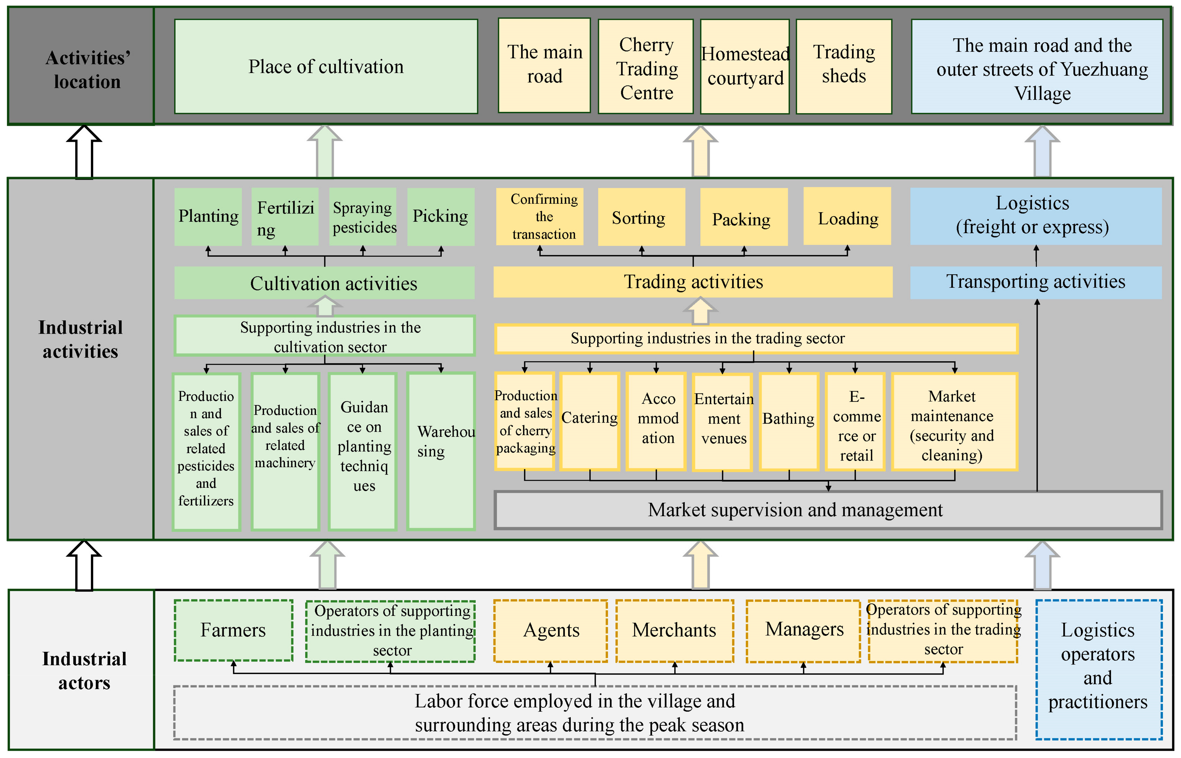
Based on the group discussion and interviews with 15 villagers and merchants, Figure 2 summarises the annual activities, the actors involved, and their locations in the cherry industry in Yuezhuang Village.
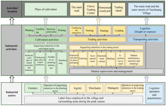
Figure 2.
Industrial actors, activities, and their locations in Yuezhuang Village. Source: Authors’ own diagrams.
The cherry industry’s annual activities in Yuezhuang Village mainly consist of three stages. One is the growing process from November to May in the following year. This process includes planting, fertilisation, pesticide spraying, fruit picking, and other industrial activities. The supporting industries of the cultivation activities include pesticide and fertiliser production and sales, related machinery production and sales, planting technology guidance, and warehousing. The supporting industries usually run for the whole year and are located outside Yuezhuang Village. The second stage is trading activities in peak seasons (from March to May). These activities include confirming transactions, fruit selection, sorting, packaging, and loading. The supporting industries of trading activities include packaging production and sales, e-commerce, and retail. Furthermore, public services are also included, such as catering, accommodation, and bathing and entertainment venues. These activities were mainly organised by residents in Yuezhuang Village, who working as agents, managers, operators of supporting industries in this period. In addition, there is a demand for market supervision and management, which are organised by the village committee, as well as market maintenance to ensure the security and cleaning of the market during the peak season. The third stage is transporting activities in the peak season, including freight logistics and express delivery, to ensure that the cherries in Yuezhuang Village can be sent to places for sale (Figure 2).
These industrial activities attracted villagers and surrounding people to engage as different industrial actors. Farmers and relevant supporting operators were mainly involved in cultivation activities. Agents, merchants, managers, and relevant supporting operators were mainly involved in trading activities. In addition, logistics operators and practitioners were involved in transporting activities. The interactions among industrial actors are further discussed in Section 4.2. Meanwhile, these industrial activities occurred in a certain spatial scope—namely, Yuezhuang Village. Cultivation activities were usually limited within the scope of the orchard land, while trading and related activities could occur along the main road and in the Cherry Trading Centre, homestead courtyards, and temporary trading sheds in the village, which significantly influenced the spatial functions during the peak season. Transporting activities usually occurred along the main road or the outer streets of Yuezhuang Village. The changes in land use and spatial functions in Yuezhuang Village are discussed in Section 4.3.
In summary, the cherry industry in Yuezhuang Village has developed considerably over the past 30 years with a bottom-up pattern. It has extended the industrial chain from an initial cultivation industry to an assembly industry, including cultivation, trading, logistics, supporting public services, and management. The cultivated areas increased from 17 mu in 1992 to approximately 1000 mu after 2000, and the average output value per mu in 2021 was 25 times larger than that in 1996. The number of people involved in this industry increased to over 5000 people from all over the country from the initial 17 households in the village. Along with the industrial development, urban–rural factors (labour, investments, information, and techniques) developed in Yuezhuang Village and flowed regionally, transforming the village from a primarily residential and agricultural site into an industrial cherry centre with diversified new functions. The agglomeration of industrial activities showed a strong correlation with the cherry growing season and significantly influenced the land use and functions of the existing rural space. Thus, the seasonal characteristics of the cherry industry in Yuezhuang Village needed to be analysed to illustrate the characteristics of the local social networks and spatial functions influenced by industrial activities.
4.2. Social Networks: Actors’ Interactions Driven by Industrial Planting Activity
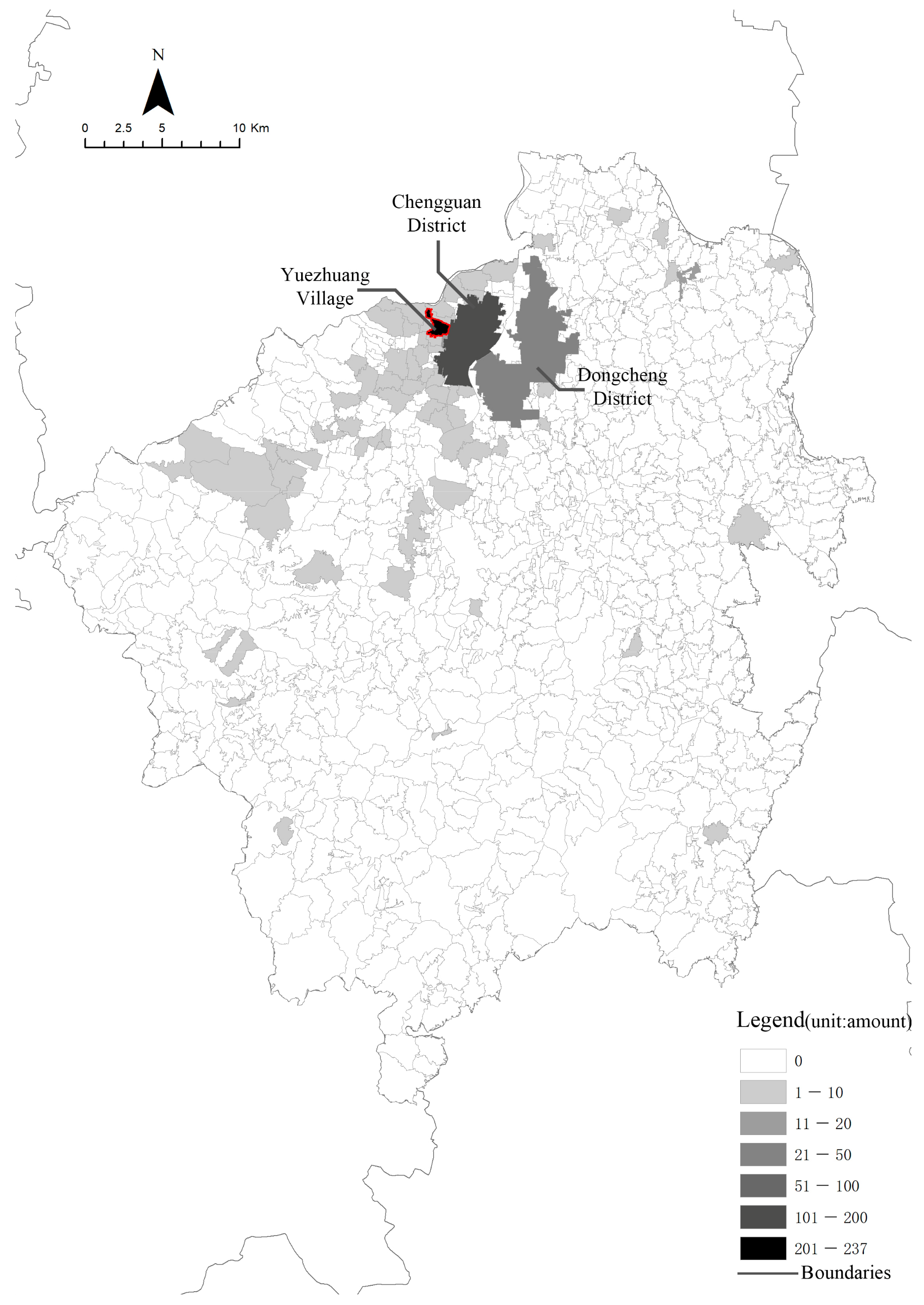
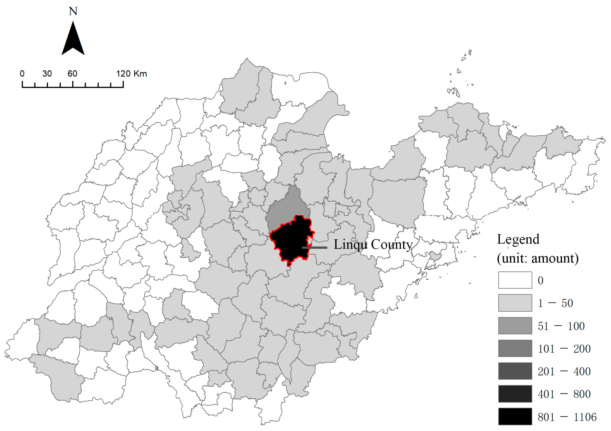
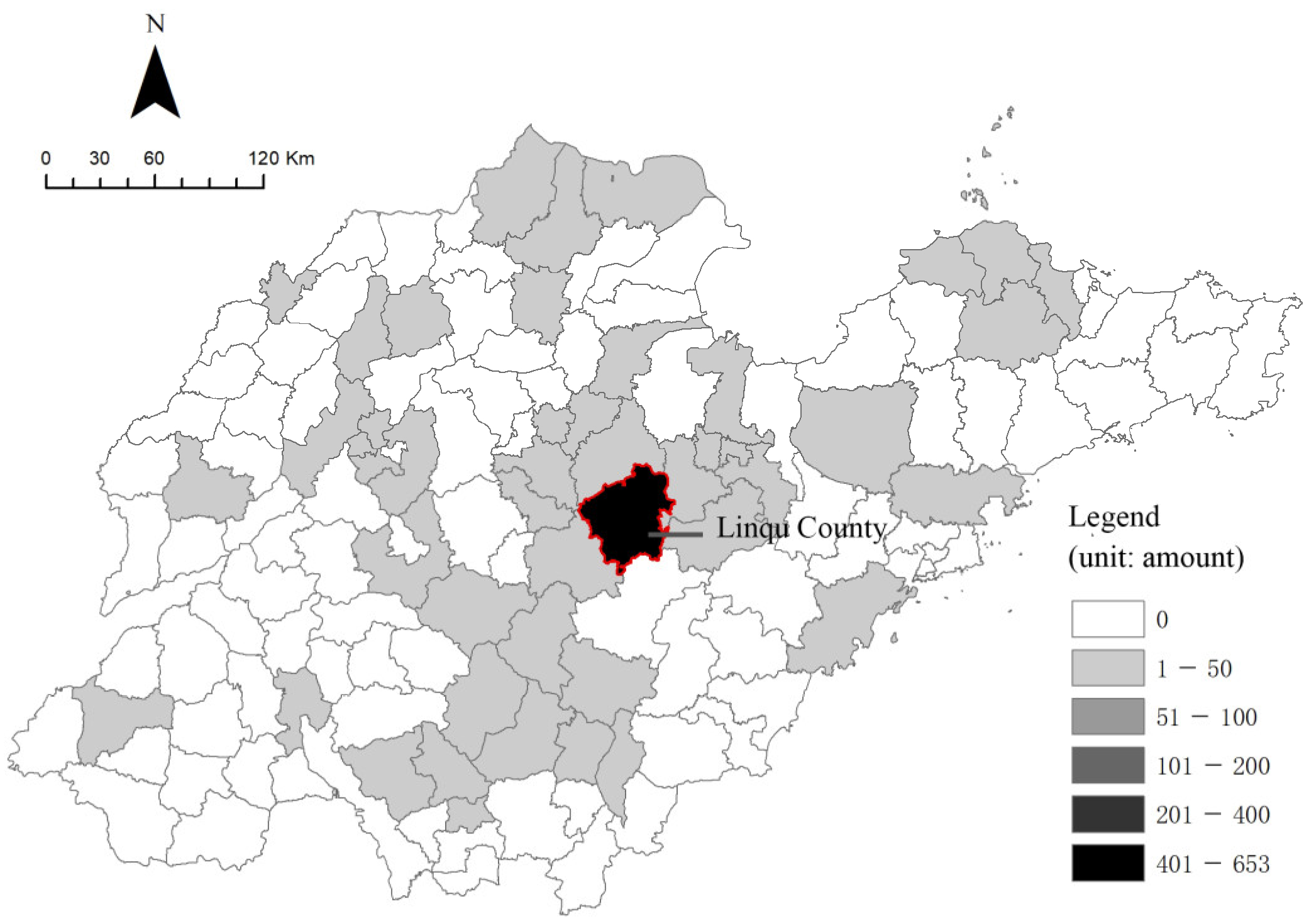
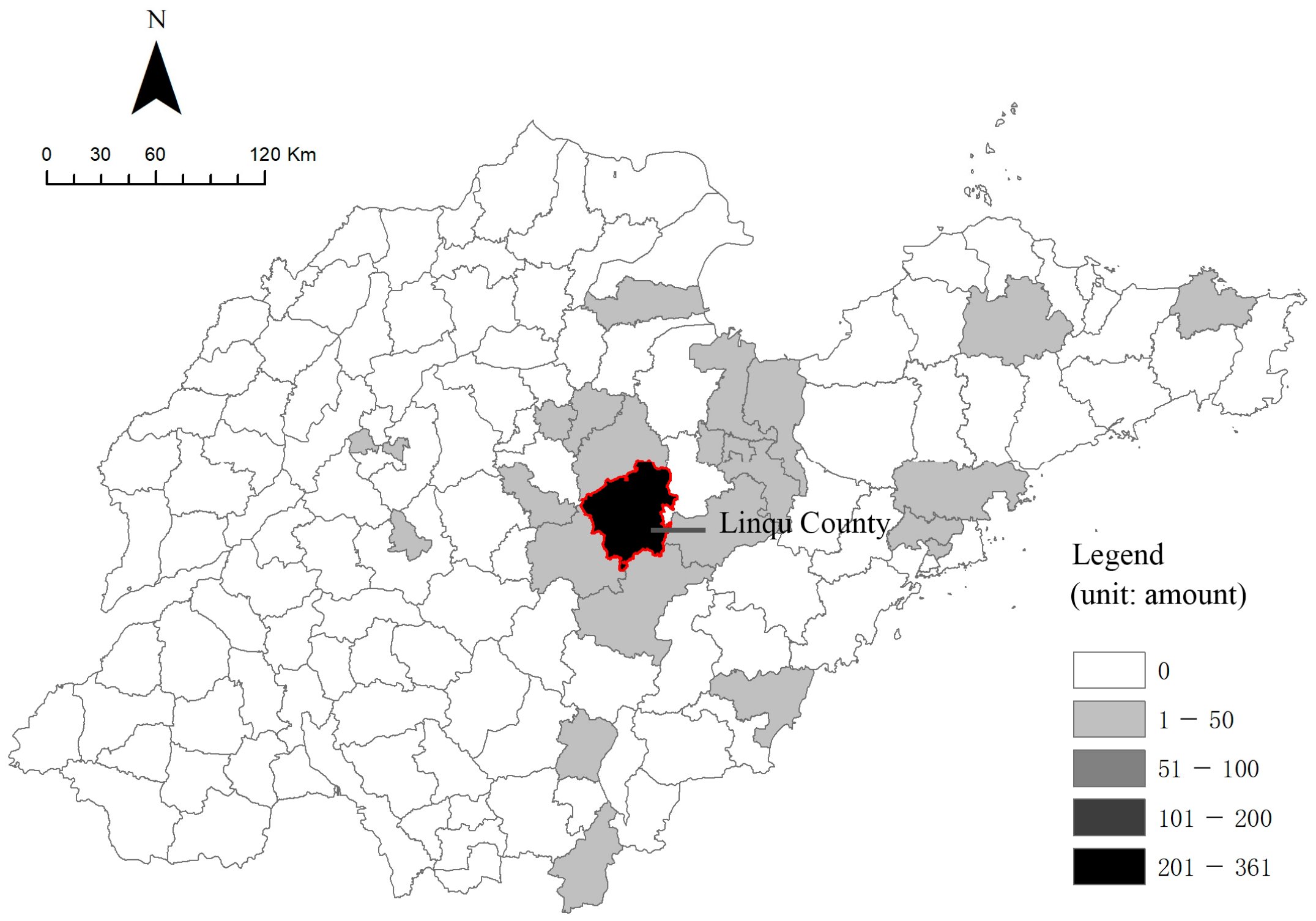
As mentioned in Section 3.2, this research used the daily trajectories of LBS data to identify the residences and working places of actors to reflect the seasonal characteristics of the cherry planting industry. Figure 3, Figure 4, Figure 5, Figure 6, Figure 7, Figure 8, Figure 9 and Figure 10 show the spatial distribution of the residences of the actors who worked in Yuezhuang Village, and the spatial distribution of the workplaces of the actors who lived in Yuezhuang Village during the planting season (April) and the off-peak season (September) within Linqu County and Shandong Province, respectively, based on LBS data obtained in 2019.
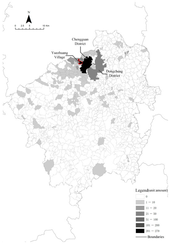
Figure 3.
The spatial distribution of residences of actors who worked in Yuezhuang Village in April (within Linqu County). Source: Authors’ own diagrams.
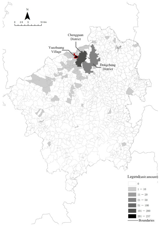
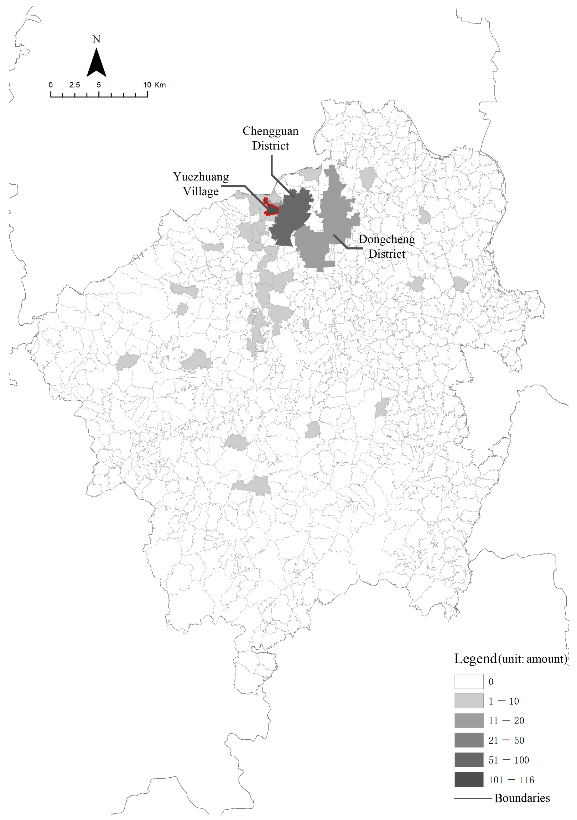
Figure 4.
The spatial distribution of working places of actors who lived in Yuezhuang Village in April (within Linqu County). Source: Authors’ own diagrams.

Figure 5.
The spatial distribution of residences of actors who worked in Yuezhuang Village in September (within Linqu County). Source: Authors’ own diagrams.
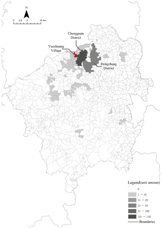
Figure 6.
The spatial distribution of working places of actors who lived in Yuezhuang Village in September (within Linqu County). Source: Authors’ own diagrams.

Figure 7.
The spatial distribution of residences of actors who worked in Yuezhuang Village in April (within Shandong Province). Source: Authors’ own diagrams.

Figure 8.
The spatial distribution of working places of actors who lived in Yuezhuang Village in April (within Shandong Province). Source: Authors’ own diagrams.

Figure 9.
The spatial distribution of residences of actors who worked in Yuezhuang Village in September (within Shandong Province). Source: Authors’ own diagrams.
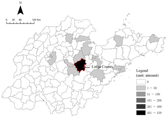
Figure 10.
The spatial distribution of working places of actors who lived in Yuezhuang Village in September (within Shandong Province). Source: Authors’ own diagrams.
During the busy planting season (April), Yuezhuang Village becomes a well-known local “employment centre”, providing employment opportunities for residents in the provincial range (Shandong Province) and especially in Linqu County, which enhances the regional urban–rural two-way flow. Compared with the number of actors who worked in Yuezhuang Village in September, this increased by more than three times in April. Of these actors, 17% lived in the village, 66% were from Linqu County, 90% were from Shandong Province, and the remaining 10% were mostly distributed in the neighbouring provinces of Shandong (Figure 3, Figure 5, Figure 7 and Figure 9). In the off-season, about 80% of the working people in Yuezhuang Village came from Linqu County, and almost all of them came from Shandong Province (Figure 6 and Figure 10). Meanwhile, the number of working actors in Yuezhuang Village in April was 1.6 times the number of residents. However, the residents of Yuezhuang Village were not fully engaged in cherry growing activities in the village, and some of them worked in nearby districts (Chengguan and Dongcheng; Figure 3 and Figure 4), which indicates that the social networks formed by the residents of Yuezhuang Village and the actors of the cherry industry overlapped to some extent but did not completely coincide. Additionally, Yuezhuang Village was mainly used for residential functions outside of the growing season, when the number of residents within it was 45% lower than that in April.
Urban–rural factors (capital, techniques, information, etc.) driven by the cherry planting industry regularly and frequently enhanced the interactions among multiple actors, forming a tight local social network. There were three main types of actors in the Yuezhuang Village case: (1) cherry farmers and supporting industry operators in the cherry growing process; (2) agents, merchants, market managers, and supporting industry operators in the cherry transaction process; and (3) logistics operators and practitioners (Figure 2). The interactions driven by the agri-food chain activities were as follows. Cherry farmers in Yuezhuang Village managed the growing and picking of cherries and employed labour from surrounding areas (shown in Figure 6) to help with the fertilisation, pesticide spraying, and fruit-picking activities during the planting season (usually in late March and April). Young villagers, mostly the children of cherry farmers, became cherry-trading agents for the trading process during the peak season (usually in April and May) and coordinated cooperation between cherry farmers and merchants from home and abroad. Meanwhile, cherry-trading agents hired short-term workers to assist the merchants with the following: sorting and packaging activities; collecting booth fees, management fees, and weighing fees; and delivering cherries to logistics company operators for transportation. Additionally, the village committee’s market supervision and management personnel, as well as the market environment maintainers (security and cleaning), also played key roles in industrial activities. As a result, the residents who served as multiple actors in industrial activities frequently interacted with each other and various urban–rural factors, forming a tight social network.
The above social network has two characteristics according to the features of the cherry industry. Firstly, the roles of actors in the social network could be changed to meet the demands of the industrial activities. On the one hand, the cherry trading and supporting services were labour-intensive industries with low technological content and a weak division of labour, leading to the possibility of changing job content for the actors. On the other hand, the agglomeration of the cherry planting industry offered multiple job options for participants. In Yuezhuang Village, temporary hired workers could undertake multiple tasks, such as cherry picking, sorting, and packaging for multiple farmers, agents, or merchants on the same day. In this case, the change in job content promoted interactions among multiple actors in the social network. Secondly, besides the tight connection based on consanguinity and geographical proximity, the actors in this social network spontaneously interacted with each other through online platforms, accelerating the urban–rural factors’ flows in the cherry industry, which strengthened the interdependence of the actors in the social network and, in turn, improved the efficiency and scale of industrial activities, generating new demands for the spatial construction of the village.
4.3. Spatial Adaptation: The Changes in Land Use and Spatial Functions
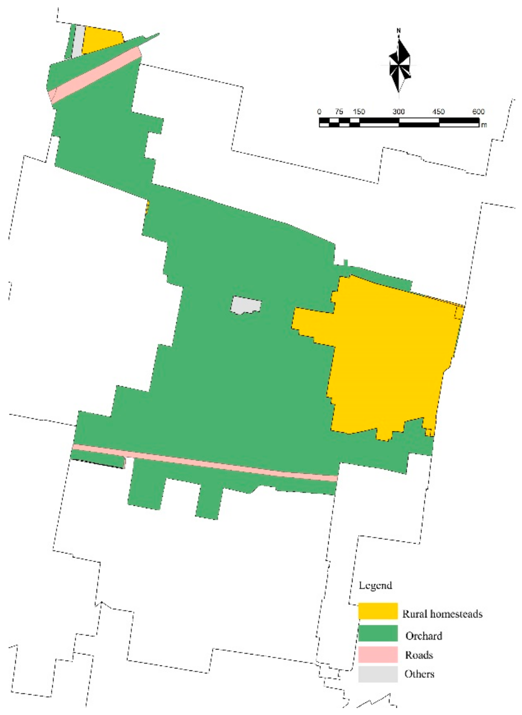
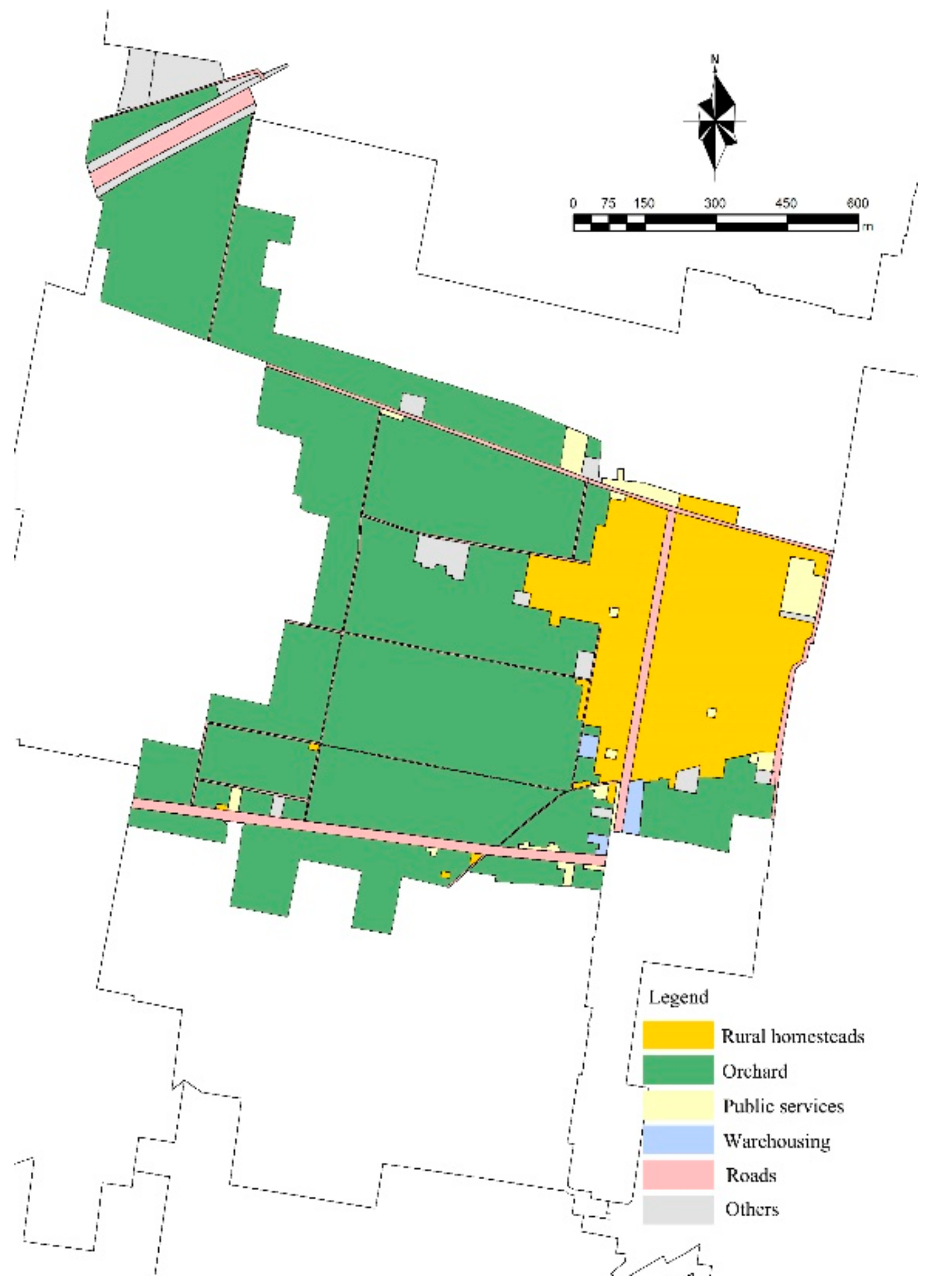
The changes in land use are essential evidence of the evolution of the cherry industry in Yuezhuang Village. Figure 11 and Figure 12 show the changes in land use in Yuezhuang Village between 2009 and 2019, and Table 1 shows the areas of each type of land use. Compared with 2009, the total area of the village remained the same, but the number of categories of land use had increased considerably. Among them, public service land and warehousing land were two sectors relating to cherry transaction activities that had increased significantly since 2010. Meanwhile, the road area in Yuezhuang Village doubled between 2009 and 2019, indicating the increasing demands of trading and transporting activities during the third period of the cherry industry.
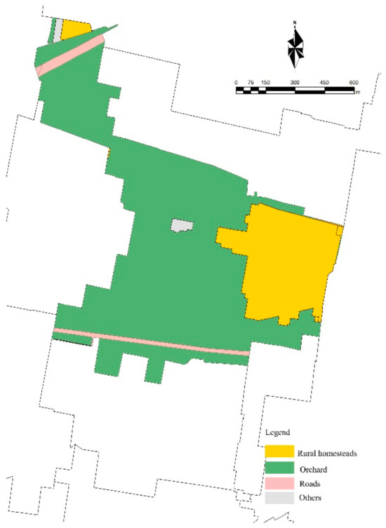
Figure 11.
The land use in Yuezhuang Village at the end of 2009. Source: Authors’ own diagrams.

Figure 12.
The land use in Yuezhuang Village at the end of 2019. Source: Authors’ own diagrams.

Table 1.
The area of each type of land use in Yuezhuang Village in 2009 and 2019.
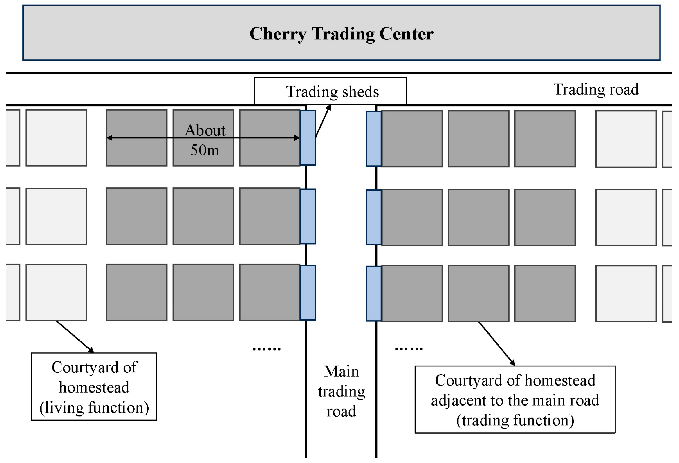
Besides the changes in land use, the spatial functions changed to adapt to the new demands of actors in social networks driven by industrial activities, leading to the adaptive use of existing spaces and new spatial construction in Yuezhuang Village. With the needs of transaction activities growing since 2010, the Cherry Trading Centre (built in 2008) could barely contain most of the industrial activities during the peak season; thus, the main road in Yuezhuang Village became the main space for trading, shipping, and other industrial activities. Meanwhile, the function of homesteads also changed. Trading sheds built in the courtyard of homesteads and courtyards adjacent to the main road became trading, warehousing, and industrial service spaces, mainly utilised for receiving, sorting, and packaging functions. These were originally used as living areas. According to observations, 162 courtyards along the main road, accounting for about 25% of all courtyards in Yuezhuang Village, were temporarily used for industrial activities due to their good accessibility and proximity to the main road during the peak season (Figure 13).
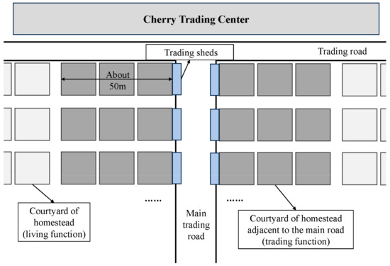
Figure 13.
Changes in the functions of courtyards and the main road in Yuezhuang Village during the peak season. Source: Authors’ own diagram.
The changes in land use and spatial functions also accelerated the development of industrial activities and social networks and caused various social and spatial issues in Yuezhuang Village due to land restrictions. Limited to the territorial scope of the village, the height regulations for construction, and the regulations for land use, planting and trading activities could only adapt the current land use and spatial construction in Yuezhuang Village, which restricted the further acceleration of urban–rural factors driven by the cherry industry. This situation led to various social and spatial issues, such as difficulties in transportation, loading, and parking due to insufficient trading space, safety issues, and traffic congestion due to the coexistence of people and vehicles, and noise issues due to mixed living and trading activities in courtyards in both Yuezhuang Village and the surrounding areas. Additionally, the planting industry actors actively or passively adapted to the phased utilisation of space. In the peak season, some of the residents in Yuezhuang rented out their homestead courtyards to short-term industrial workers and temporarily lived in greenhouses on the planting land, leading to possible issues in terms of unsuitable living conditions.
4.4. The Mechanism of Socio-Spatial Evolution Driven by Industrial Development
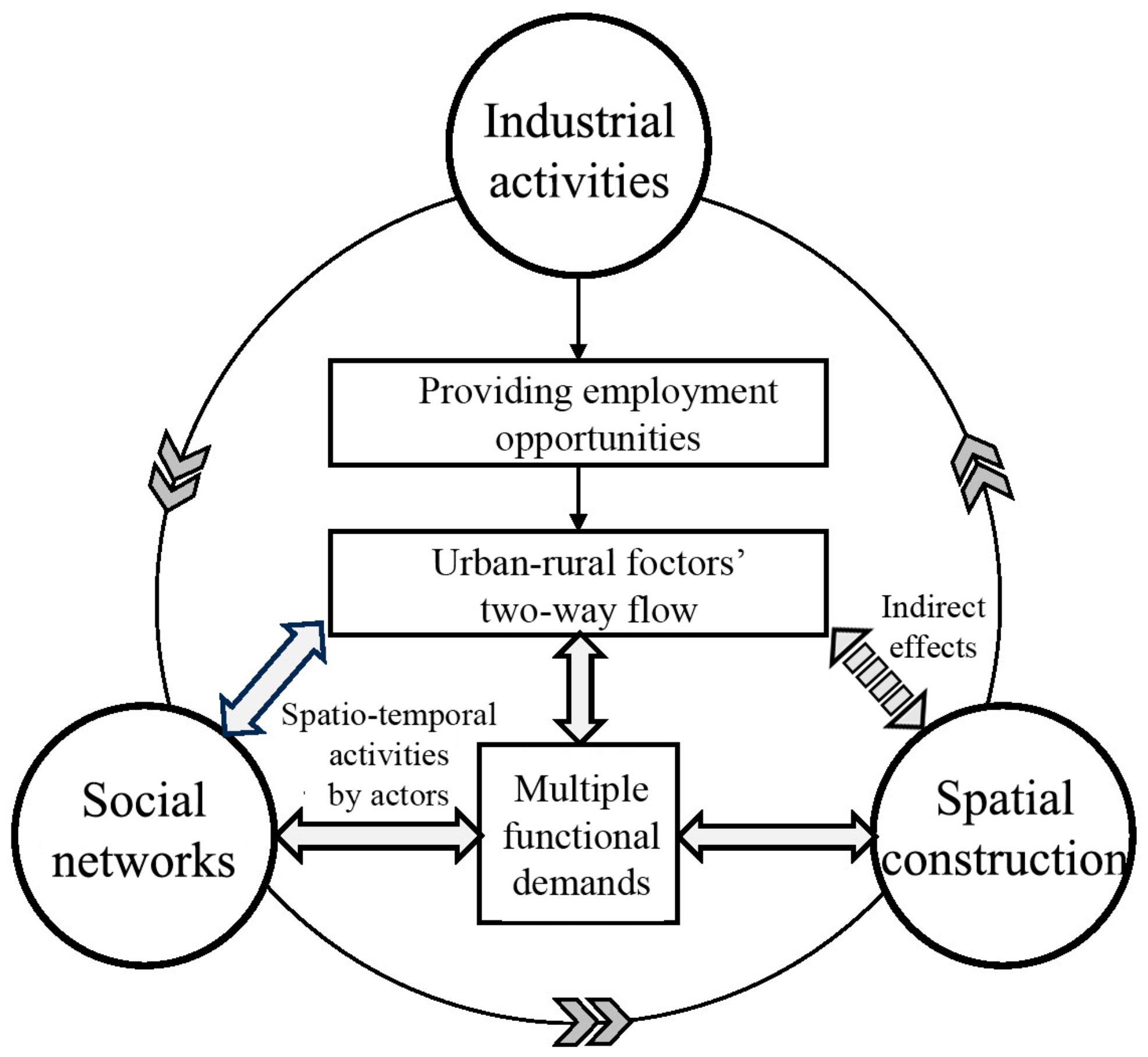
Industrial activities concentrated various urban and rural factors within a specific temporal and spatial range, forming a strong correlated social network and promoting a change to the existing rural space. By providing local employment opportunities, the cherry industry attracted urban and rural practitioners who gathered annually within a particular territorial range (Yuezhuang Village) during certain months (the peak season of the industry), promoting the development of industrial organisation, which was initiated from the bottom up. Such development caused the agglomeration effect of urban–rural factors (population, capital, technology, information, etc.) related to industry and integrated the upstream and downstream industrial chain to maximise benefits, such as planting and planting support services, trading and trading support services, transport logistics, and market management. Meanwhile, the development of the cherry industry formed a tightly connected local and regional social network through the interaction of multiple actors driven by industrial activities and generated new and multiple functions in rural areas. The new demands changed the existing spatial functions and, to some extent, improved the spatial quality of these areas. The adaptive socio-spatial evolution mechanism driven by industrial development is shown in Figure 14.

Figure 14.
Socio-spatial evolution mechanism driven by industrial development. Source: Authors’ own diagram.
There are three interdependent chains in the above mechanism, constituting the complete industrial–socio-spatial evolution process: (1) the interaction between the two-way flow of urban–rural factors and multiple functions driven by the cherry industry; (2) the interaction between the spatio-temporal activities of actors and the evolution of social networks; and (3) the interactions between multiple functions, social networks, and spatial construction and utilisation in rural areas. Through flexible employment during the peak season, many labourers from surrounding counties and cities temporarily gathered in Yuezhuang Village and were involved in the local social network. Through the different industrial activities they engaged in, they shaped the new usage of the existing venue space in rural areas, generated multiple functions to demand industrial activities, and further strengthened the agglomeration of urban–rural factors. Meanwhile, relying on the construction of urban–rural infrastructure and the Internet, these factors simultaneously interacted with each other at the cross-regional level beyond the specific scope of rural areas. The existing space in Yuezhuang Village, such as the main road and homesteads, became an inclusive place for neighbourly communication and the exchange of industrial information, which consolidated the geographical social network and strengthened corporations of industrial actors during the peak season. New demands for the construction of rural infrastructure and public services that were also generated from the abovementioned activities and networks promoted the inclusive and variable utilisation of the existing rural spaces with multi-actor collaborations in different periods of industrial development. This evolution process further strengthened the agglomeration of urban–rural industrial factors and social network connections, promoting the sustainable development of rural industries and constructions.
5. Discussion
5.1. Complexity of the Mechanism
The socio-spatial evolution process driven by rural industries is complex due to the interactions among components. In this study, the industrial activities shaped and constrained the spatio-temporal behaviours of the participating industrial actors, and the interaction between social networks and their spatial carriers had two sets of “friction forces”. One was the friction between the pursuit of the “global optimal” industrial organisation and the optimal choice of participating actors’ spatio-temporal industrial activities [58]. Individuals sought to optimise the benefits (efficiency and completion) of the multi-purpose behaviours within a specific time and space range, which did not necessarily lead to the maximisation of group behaviour benefits. The endogenous contradiction between the two led to the loss of internal efficiency in the industrial organisations. To reduce this “friction force”, spatial carriers, which were jointly shaped by social network entities and industrial activities [59], also had a reverse effect. Although showing the potential for adaptive use, the existing limited functions of the carriers still constrained individual’s industrial activities within a specific period (the peak season), leading to the relatively coordinated development of individuals and the industrial organisation. The other friction force was between the pursuit of a “globally optimal” industrial organisation and spatial construction. Urban–rural factors driven by industrial activities pursued the optimal scale and benefits. With the cross-spatio-temporal characteristics of these factors, the evolution process was often faster than the construction of its spatial carriers, resulting in a temporary imbalance between the function and space. To meet the new needs of these industrial activities over time, the actors first needed to temporarily change the use of existing spatial carriers and then promote the construction of new, more suitable ones.
Categories of rural industries can also influence the interactions among components in the socio-spatial evolution process. The two types of “friction” were characterised differently according to the differences of various industrial organisations, where the constraints on the spatio-temporal behaviours of participating individuals were different. Meanwhile, existed in various spatial hierarchies and scopes, urban-rural factors gathered in different ways driven by various industrial activities, influenced the formulation of social networks and spatial constructions. For instance, the activities of the primary industry were widely spread across various land types in urban and rural areas, and the social network strongly relied on geographical connections [24]. Thus, there were higher demands for suitable and adaptive space construction and use compared with those of the secondary and tertiary industries. Meanwhile, activities in the tertiary industry mostly relied on digital technology and Internet facilities or could be completed in concentrated areas and, thus, were less affected by the spatial and temporal scope. This type of social network is usually formed online across regions [35]. Thus, the correlation between industrial activities and space construction and use was relatively weak.
In summary, the factors in industrial activities interact and form a social network to influence the socio-spatial interaction with spatial carriers. The three key components in the socio-spatial evolution mechanism driven by industrial development were interrelated and coordinated and were influenced by the dominant industry categories. Compared with the gradual evolution of rural functions and social networks, spatial construction had a certain lag.
5.2. Current Rural Planning Policies and Planning Inspiration in China
Learning from the empirical case study, the inclusive development of both rural industries and communities is important for promoting social networks and spatial construction, which needs to be considered in current rural planning policies in China. Relevant strategies for inclusive development are listed in the SDGs, action frameworks, and inspiring practices published in UN-Habitat [60,61] to ensure sustainable development in rural areas. In response to these, strategies such as providing inclusive employment opportunities, encouraging small industries, and enhancing the liveability of rural areas are also listed in the national Rural Revitalisation Strategy and relevant opinions released by the Central Committee of the Communist Party and the State Council of China [3]. However, more detailed strategies and approaches to inclusive development, which adapt to current developments in rural areas, still need to be considered. As illustrated in this study, planting industries, which are highly rooted in rural areas, offer localised employment positions with low labour skill requirements and absorb the labour force scattered throughout urban and rural areas to form a new rural social network. To meet the demands of the actors in the network and the seasonal characteristics of industrial activities, consideration must be made as to where and how suitable spatial carriers can be constructed. Additionally, carrying out industrial training to improve the quality of the labour force is helpful for inclusive and sustainable industrial development and further strengthens the flow of urban–rural factors towards a virtuous cycle of socio-spatial evolution.
The policies for rural industrialisation should focus on the impact of the two-way flow of urban–rural factors driven by industrial activities on the local socio-spatial evolution, especially in urban–rural interfaces. As the empirical case study indicated, industries strongly rooted in rural areas, such as the planting industry, can attract the flow of urban–rural factors from cities to rural areas, which breaks the development pattern of urban siphoning of rural resources in the past rapid urbanisation stage in China. Such a new pattern may alleviate the population outflow and the environmental degradation in rural areas, contributing to urban–rural integration and rural revitalisation. In the new era, policies should encourage the improvement of industrial chains and the construction of rural social networks based on traditional agriculture, encourage the agglomeration of industrial factors in rural areas, and promote the coordinated development of rural society and space. Meanwhile, due to the accessibility of transportation, urban–rural interfaces may be the primary areas influenced by the flow of urban–rural factors [62,63,64]. As illustrated in this research, Yuezhuang Village is located in the urban–rural interface of Linqu County. To better encourage rural industrialisation, more comprehensive infrastructure construction, land and water supply, public services, and financial policies, etc., need to be considered in the policies for rural revitalisation, and guaranteeing mechanisms for policy implementation processes is also needed.
Reserving flexible land and space for future industrial development was found to be essential for the current rural revitalisation in China. Rural industrialisation has attracted more frequent two-way flows of urban–rural factors since the Industrial Revitalisation Strategy was released, extended their industrial chains to relevant high-value-adding industries, and generated new functional demands for rural space. This process inevitably led to conflicts with the current situation of rural land use. To support the future development of rural areas, national policies have been developed to reserve flexible spaces in potentially useful areas; however, due to restrictive land-use policies to protect food security [11], it is difficult to obtain enough land for rural industrial development in rural areas. To achieve the maximum balance between protection and development, on the one hand, rural spatial planning should fully consider the characteristics of dominant industries and their inherent laws of evolution over the mid-term period, as well as the current stage of the construction of spatial carriers, and develop strategies for both land use and phasing; on the other hand, the allocation of reserved flexible land in rural areas needs to be coordinated at the county level in terms of territorial and spatial planning to ensure the sustainable development of essential industries in this region. Additionally, specific industrial and neighbourhood plans can be made if necessary to maximise the effectiveness of reserved flexible rural land.
In addition, the scattered property rights of rural land and the limited availability of construction land are not conducive to attracting foreign capital for long-term investment. In the case of Yuezhuang Village, villagers own both orchards and homesteads and can use their own land as farming and trading venues during the peak period. Meanwhile, they attract people from across the county to join industrial activities through land leasing. This method has shown its effectiveness currently; however, it is not conducive to the future development of the industrial chain. Appropriate land policies should be considered to address the future extension of rural industrial chains and attract foreign capital and labour to villages. Meanwhile, the dispersion of rural land ownership makes it difficult to unify management in the rural industrialisation process, which may lead to unclean rural environments, incomplete public services, and difficulties in gathering urban–rural factors for future development. These should also be considered in future policies on rural industrial revitalisation in China.
6. Conclusions
In general, the case of Yuezhuang Village showed that the two-way flow of urban and rural factors brought development opportunities to the traditional planting industry in rural areas and established a new socio-economic form based on characteristic industrial activities that integrated urban and rural areas, which fundamentally broke the single function and organisational structure of traditional villages limited to agricultural production. Benefitting from policies supporting agricultural industries in the early 2000s and the Rural Revitalisation Strategy and Urban–Rural Integration Strategy after 2018, socio-spatial evolution driven by rural industries is clearly observable over the past two decades. This research on Yuezhuang Village showed that, driven by rural talents and with the spontaneous participation of villagers, the cherry industry gradually formed an industrial chain with bottom-up development over 30 years, mainly consisting of planting, wholesale, logistics, the support of production and public services, and management in rural areas. The extension of the industrial planting chain drove the agglomeration and interaction of urban–rural factors within and outside of the county, provided inclusive employment opportunities, and formed a new and sustainable social network. With the support of transportation infrastructure and the Internet, this produced an industrial organisation model across time and space, promoting the two-way flow of urban–rural factors and the adaptable change of rural space.
This research highlighted the theoretical mechanism of socio-spatial evolution driven by current industrial development in China and presented a typical empirical case relevant to the SDGs for further academic discussion. The pattern of development of the cherry industry in Linqu County contrasted the traditional path of urban areas siphoning resources from rural areas during rapid urbanisation. Due to the deep embeddedness of the agri-food sector, the urban–rural factors mainly flowed from Shandong Province, i.e., regional-level urban areas, to Yuezhuang Village, i.e., rural areas. This indicates that small-scale, characteristic, and traditional agriculture can become one of the main driving forces in urban–rural integration towards sustainable development. Rather than large-scale secondary industries developed in urban areas, this research revealed an environmentally friendly and proper industrial revitalisation pattern for rural areas and discussed these impacts on the socio-spatial development in rural China. By offering decent jobs and improving economic growth, rural industries promote local social networks, infrastructure construction, and public services in rural areas, leading to sustainable and inclusive rural communities and urban–rural partnerships. Thus, the case studied here comprehensively implemented multiple SDGs, providing a typical empirical study for urban–rural integration in China.
This research has some limitations. As discussed in Section 4.1, the socio-spatial mechanism can differ among different rural industrialisation processes. The characteristics of the urban–rural factors involved and the interactions among them can be numerous in the above processes, resulting in various functional demands in rural areas. Likewise, the formulation processes used in local social networks and rural constructions may also be characterised differently. Thus, further studies on the socio-spatial mechanism driven by other rural industries, such as secondary and tertiary industries, and within different geographical scopes should be conducted. Additionally, the LBS data used in this research were considered a sampling survey to illustrate the spatial distribution of the workplaces and residences of actors in Yuezhuang Village. This is because these data only reflected the distribution of certain groups of people who used smartphones during a certain period. This research triangulated the LBS data with participatory observations, in-depth semi-structured interviews, focus groups, and mapping to improve the accuracy of the data.
Author Contributions
Conceptualization, L.W. and G.Y.; Formal analysis, L.W.; Funding acquisition, G.Y.; Investigation, L.W.; Methodology, L.W.; Project administration, G.Y.; Supervision, G.Y.; Visualization, L.W.; Writing—original draft, L.W. All authors have read and agreed to the published version of the manuscript.
Funding
The work was produced in association with the ‘Research on the Spatial Differentiation Mechanism and Planning Regulation of Rural Settlements: A Case Study of Zhejiang’ (No. 52378067), and ‘Guiding Mechanism of Rural Employment Post Distribution and Its Spatial Impact: A Case Study of Zhejiang and Shandong Areas’ (No. 51978476), funded by the National Natural Science Foundation of China (NSFC).
Data Availability Statement
The raw data supporting the conclusions of this article is unavailable due to privacy restrictions, and further inquiries can be directed to the corresponding author.
Conflicts of Interest
The authors declare no conflicts of interest.
Ethics Statement
The interviewees’ information is secure. The empirical evidence obtained from multiple field visits between 2019 and 2023 is securely stored and limited in use to this research only. Confidentiality and privacy were ensured by anonymising the data used in this research. Political and cultural sensitivities (as well as data bias) were seriously taken into account. The authors are highly aware of privacy protection and unwarranted surveillance when applying LBS data in research. The highest level of sensitivity to using LBS data was maintained. The data were obtained from the credible data firm Aurora in an already fully anonymised form. There is no detailed information that can be linked to specific persons or locations.
References
- United Nations. Transforming Our World: The 2030 Agenda for Sustainable Development; United Nations: New York, NY, USA, 2015.
- Luo, W.; Wang, W.; Lin, Z.; Zhou, W. Spatio-temporal evolution and driving factors of urban-rural integration in China. Prog. Geogr. 2023, 42, 629–643. [Google Scholar] [CrossRef]
- The Central Committee of the Communist Party of China and the State Council of China issued Rural Revitalization Strategic Plan (2018–2022)]. Available online: http://www.gov.cn/zhengce/2018-09/26/content_5325534.htm (accessed on 31 March 2024).
- Opinions of the Central Committee of the Communist Party of China and the State Council on Establishing and Improving the Institutional Mechanism and Policy System for Integrated Urban-Rural Development]. Available online: http://www.gov.cn/zhengce/2019-05/05/content_5388880.htm (accessed on 31 March 2024).
- Yang, G. Multiple Approaches of Rural Revitalization from the Viewpoint of Urban-rural Co-construction. Planners 2019, 11, 5–10. [Google Scholar]
- Chen, W. The policy changes and future trends of the rural development in the No. 1 document of the Central Committee. Rural Econ. 2017, 7–13. [Google Scholar]
- Cheng, Z.; Cai, J.M.; Cui, L.; Liu, Y.S. Facilitating rural transformation development by tourism industry: A case study of Panjin, Liaoning Province. Res. Agric. Mod. 2016, 37, 143–150. [Google Scholar]
- Chen, C.; Geng, J.; Chen, X. Rural Restructuring Driven by B&B Industry and Its Implications for Planning: The Case Study of Luoling Village, Moganshan Town. Urban Plan. Forum 2019, 67–75. [Google Scholar] [CrossRef]
- Pu, X.; Liu, Q.; Xie, B. The Historical Stages and Characteristics of Urban-rural Relationship Driven by Relevant Elements. Planners 2018, 34, 81–87. [Google Scholar]
- Li, Q.; Huang, F. Effect and Countermeasures for the Drain of Rural Labor Force on Agricultural Modernization. J. Guangxi Norm. Univ. Natl. 2015, 32, 100–102. [Google Scholar]
- The State Council of the PRC. The National Land Use Planning Framework; Xinhua News Agency: Beijing, China, 2008. [Google Scholar]
- Liu, Y. Scientifically promoting the strategy of reclamation and readjustment of rural land in China. China Land Sci. 2011, 25, 3–8. [Google Scholar]
- Liu, Y.; Fang, F.; Li, Y. Key issues of land use in China and implications for policy making. Land Use Policy 2014, 40, 6–12. [Google Scholar] [CrossRef]
- Zhang, Y. Dilemma of China’s Urbanization and Land Expropriation—Based on the Farmland Property Rights of Thinking. J. Northwest AF Univ. (Soc. Sci. Ed.) 2014, 14, 16–31. [Google Scholar] [CrossRef]
- Fei, X. Urban-Rural Development in China—My Lifetime Reasearch Project. Chinses J. Sociol. 1993, 01, 3–13. [Google Scholar]
- Yang, R.; Yang, Q. Restructuring the State: Policy Transition of Construction Land Supply in Urban and Rural China. Land 2021, 10, 15. [Google Scholar] [CrossRef]
- Lin, J.; Li, H.; Lin, M.; Li, C. Rural e-commerce in China: Spatial dynamics of Taobao Villages development in Zhejiang Province. Growth Change 2021, 53, 1082–1101. [Google Scholar] [CrossRef]
- Xu, S. A review of the impact of urban-rural relations on rural areas and farmers. Rural Econ. Sci.-Technol. 2014, 25, 122–125. [Google Scholar]
- Wang, M. Spatial Characteristics and Planning Strategies of Rural Industries Guided by Industrial Revitalization: A Case Study of the Urban Pastoral Complex in the Dongxihu District of Wuhan. City Plan. Rev. 2023, 47, 105–114. [Google Scholar]
- Mao, M.; Luo, Z.D.; Lan, J. The Development Strategy and Planning Methodology for the Remote Countryside from the Perspective of Country in Flows: Taking Loushang Village of Guizhou Province as a Case. J. Hum. Settl. West China 2021, 36, 19–25. [Google Scholar]
- Li, F.; Zhao, M.; Huang, J. The Performance of Spatial Structure and the Choice of Development Model of Mage-City. Urban Plan. Forum 2021, 01, 18–27. [Google Scholar] [CrossRef]
- Li, Z.; Liu, D.; Lin, S. A Literature Review of the Study on Return Floating Population in China. Hum. Geogr. 2020, 35, 1–10. [Google Scholar]
- Wang, K.; Feng, Y.; Zhang, Y. Development Process, Logic, and Prospect of Rural Human Settlements after Reform and Opening-up. City Plan. Rev. 2023, 46, 77–86. [Google Scholar]
- Chen, C.; Yang, G.; Xu, H.; Wang, Y. Understanding Rural Development Driven by Small Local Industries and Its Planning Strategies: The Case of Zhejiang Province. Planners 2021, 37, 21–27. [Google Scholar]
- Yang, G.; Guan, Z. On Rural Spatial Distribution Optimization Based on the Theory of Productivity and Production Relations. J. Hum. Settl. West China 2018, 33, 1–6. [Google Scholar]
- Yang, G. Rural Evolution: Reviewing the Rebirth of Traditional Rural Settlements from the Perspective of “Productivity-Spatial Form” Theory. J. Tongji Univ. (Soc. Sci. Ed.) 2022, 33, 66–73. [Google Scholar]
- Amjad, R. Small-scale industries and rural development: Implications for rural industrialisation in Pakistan. In Rural Small Scale Industries and Employment in Africa and Asia: A Review of Programmes and Policies; Chutta, E., Sethuraman, S.V., Eds.; United Nations: New York, NY, USA, 1984; pp. 93–159. [Google Scholar]
- Kakati, B.K. Gram Swaraj: The Sustainable Model for Rural Industrialisation and Employment. Int. J. Community Soc. Dev. 2021, 3, 274–289. [Google Scholar] [CrossRef]
- Agasty, D.M.P. Migration of Labour and Urban-Rural Linkages: A Case Study of Rural India. Indian J. Econ. Dev. 2018, 6. Available online: www.iseeadyar.org (accessed on 31 March 2024).
- Krishna, A. Globalised Growth in Largely Agrarian Contexts: The Urban–Rural Divide; Effective States and Inclusive Development Research Centre, The University of Manchester: Manchester, UK, 2018. [Google Scholar] [CrossRef]
- Ma, X.; Huang, T. China’s Rural Industrialization and Agricultural Mechanization. China World Econ. 2023, 31, 27–58. [Google Scholar] [CrossRef]
- Ji, X.; Chen, J.; Zhang, H. Agricultural Specialization Activates the Industry Chain: Implications for Rural Entrepreneurship in China. Agribusiness 2023. early view. [Google Scholar] [CrossRef]
- Phillipson, J.; Tiwasing, P.; Gorton, M.; Maioli, S.; Newbery, R.; Turner, R. Shining a Spotlight on Small Rural Businesses: How Does Their Performance Compare with Urban? J. Rural Stud. 2019, 68, 230–239. [Google Scholar] [CrossRef]
- Desai, V. Small Scale Industries and Entrepreneurship; Himalaya Publishing House: Mumbai, India, 2007. [Google Scholar]
- Luo, Z.; Xiang, J. New rural development and rural revitalization path in the era of mobile internet. City Plan. Rev. 2019, 43, 29–36. [Google Scholar]
- Qian, H.; Zhang, B.; Zhu, J. Urban-rural integration approach from the perspectives of pluriactivity and multi-functionalization: The case study of Dinghai District, Zhoushan. Urban Plan. Forum 2019, 82–88. [Google Scholar] [CrossRef]
- Brenner, N. The urban question as a scale question: Reflections on Henri Lefebvre, urban theory and the politics of scale. Int. J. Urban Reg. Res. 2000, 24, 361–378. [Google Scholar] [CrossRef]
- Brenner, N. (Ed.) Implosions/Explosions: Towards a Study of Planetary Urbanization. De Gruyter; Jovis: Berlin, Germany, 2021. [Google Scholar] [CrossRef]
- Harvey, D. The Condition of Postmodernity: An Enquiry into the Origins of Cultural Change; Wiley-Blackwell: Oxford, UK; Cambridge, MA, USA, 1991. [Google Scholar]
- Yan, L. A Theoretical Analysis on the Structural Effects of Space of Flows. Urban Plan. Forum 2021, 32–39. [Google Scholar] [CrossRef]
- Brenner, N. New Urban Spaces: Urban Theory and the Scale Question; Oxford University Press: Oxford, UK, 2019. [Google Scholar]
- Heley, J.; Jones, L. Relational Rurals: Some thoughts on relating things and theory in rural studies. J. Rural Stud. 2012, 28, 208–217. [Google Scholar] [CrossRef]
- Schmid, C. Henri Lefebvre and the Theory of the Production of Space; Verso: London, UK; New York, NY, USA, 2022. [Google Scholar]
- Lefebvre, H. The Production of Space; Blackwell: Oxford, UK, 1991. [Google Scholar]
- Ye, C. The Origins of Socio-Spatial Dialectic. Stud. Dialectics Nat. 2012, 28, 56–60. [Google Scholar]
- Soja, E.W. Third Space: Journeys to Los Angeles and Other Real-And-Imagined Places; Blackwell: Oxford, UK, 1996. [Google Scholar]
- Gottdiener, M.; Hutchison, R. The New Urban Sociology; Westview Press: Boulder, CO, USA, 2010. [Google Scholar]
- Meng, Q. Sociospatial Dialectics and Its Disciplinary Significance: An Analysis from the Perspective of Geography. Academics 2010, 05, 79–84. [Google Scholar]
- Chai, Y.; Tan, Y.; Shen, Y.; Guan, M. Space-behavior interaction theory: Basic thinking of general construction. Geogr. Res. 2017, 36, 1959–1970. [Google Scholar]
- Chai, Y. Methodological Problems in Behavioral Geography Study. Areal Res. Dev. 2005, 24, 1–5. [Google Scholar]
- Shortall, S.; Brown, D.L. Guest editorial for special issue on rural inequalities: Thinking about rural inequalities as a cross-national research project. J. Rural Stud. 2019, 68, 213–218. [Google Scholar] [CrossRef]
- Shi, H.; Huang, H.; Ma, D.; Chen, L.; Zhao, M. Capturing urban recreational hotspots from GPS data: A new framework in the lens of spatial heterogeneity. Comput. Environ. Urban Syst. 2023, 103, 101972. [Google Scholar] [CrossRef]
- Niu, X.; Yue, Y. The Rural Planning Research Supported by Mobile Positioning Big Data: Progress, Obstacles and Expectation. Urban Rural Plan. 2020, 02, 67–75. [Google Scholar]
- Spinney, J.E. Mobile positioning and LBS applications. Geography 2003, 88, 256–265. [Google Scholar]
- Sadoun, B.; Al-Bayari, O. LBS and GIS technology combination and applications. In Proceedings of the 2007 IEEE/ACS International Conference on Computer Systems and Applications, Amman, Jordan, 13–16 May 2007; IEEE: Toulouse, France, 2007; pp. 578–583. [Google Scholar]
- Ester, M.; Kriegel, H.P.; Sander, J.; Xu, X. A density based algorithm for discovering clusters in large spatial databases with noise. AAAI Press 1996, 96, 226–231. [Google Scholar]
- Li, X.Y.; Li, D.R. DBSCAN spatial clustering algorithm and its application in urban planning. Sci. Surv. Mapp. 2005, 3, 51–53+5. [Google Scholar]
- Wang, D.; Hu, Y. Urban Spatial-Temporal Activity Planning: Concept, Framework and Prospect. Urban Plan. Forum 2022, 44–50. [Google Scholar] [CrossRef]
- Cheng, M.; Liu, Y.; Jiang, N. Study on the spatial pattern and mechanism of rural population land-industry coordinating development in Huang-Huai-Hai Area. Acta Geogr. Sin. 2019, 74, 1576–1589. [Google Scholar]
- UN-Habitat. Compendium of Inspiring Practices on Urban-Rural Linkages: Implementation of Guiding Principles and Framework for Action to Advance Integrated Territorial Development, 3rd ed.; UN-Habitat: Nairobi, Kenya, 2023. [Google Scholar]
- UN-Habitat. Compendium of Inspiring Practices on Urban-Rural Linkages: Implementation of Guiding Principles and Framework for Action to Advance Integrated Territorial Development, 2nd ed.; UN-Habitat: Nairobi, Kenya, 2021. [Google Scholar]
- Cattivelli, V. Planning peri-urban areas at regional level: The experience of Lombardy and Emilia-Romagna (Italy). Land Use Policy 2021, 103, 105282. [Google Scholar] [CrossRef]
- Ros-tonen, M.; Pouw, N.; Bavinck, M. Governing Beyond Cities: The Urban-Rural Interface. In Geographies of Urban Governance; Gupta, J., Pfeffer, K., Verrest, H., Ros-Tonen, M., Eds.; Springer International Publishing: Cham, Switzerland, 2015; pp. 85–105. [Google Scholar]
- López-goyburu, P.; García-montero, L.G. The urban-rural interface as an area with characteristics of its own in urban planning: A review. Sustain. Cities Soc. 2018, 43, 157–165. [Google Scholar] [CrossRef]

Disclaimer/Publisher’s Note: The statements, opinions and data contained in all publications are solely those of the individual author(s) and contributor(s) and not of MDPI and/or the editor(s). MDPI and/or the editor(s) disclaim responsibility for any injury to people or property resulting from any ideas, methods, instructions or products referred to in the content. |
© 2024 by the authors. Licensee MDPI, Basel, Switzerland. This article is an open access article distributed under the terms and conditions of the Creative Commons Attribution (CC BY) license (https://creativecommons.org/licenses/by/4.0/).