
Spatio-Temporal Differentiation and Driving Factors of Land Use and Habitat Quality in Lu’an City, China


Abstract
:1. Introduction
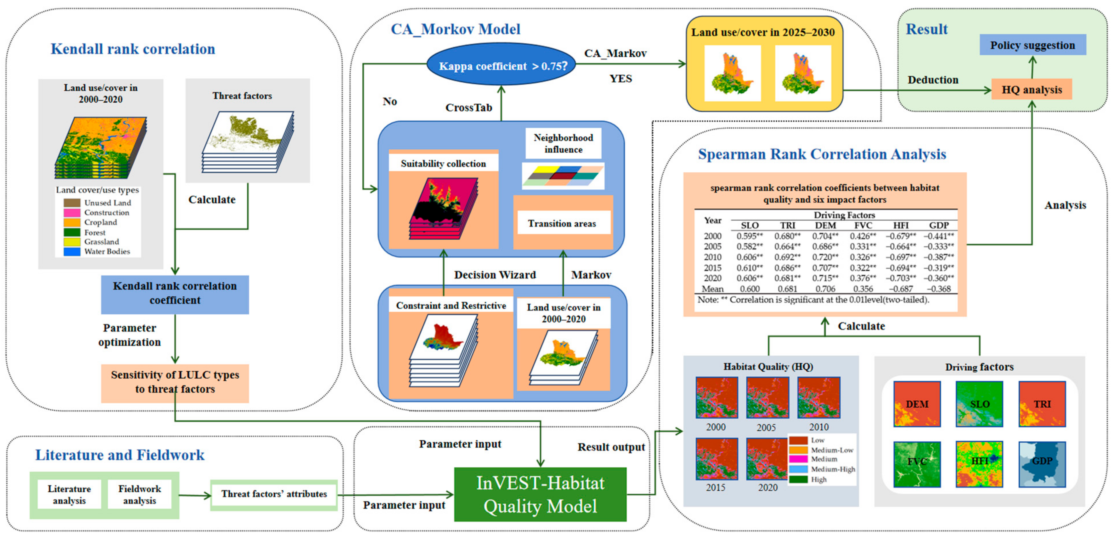
2. Materials and Methods
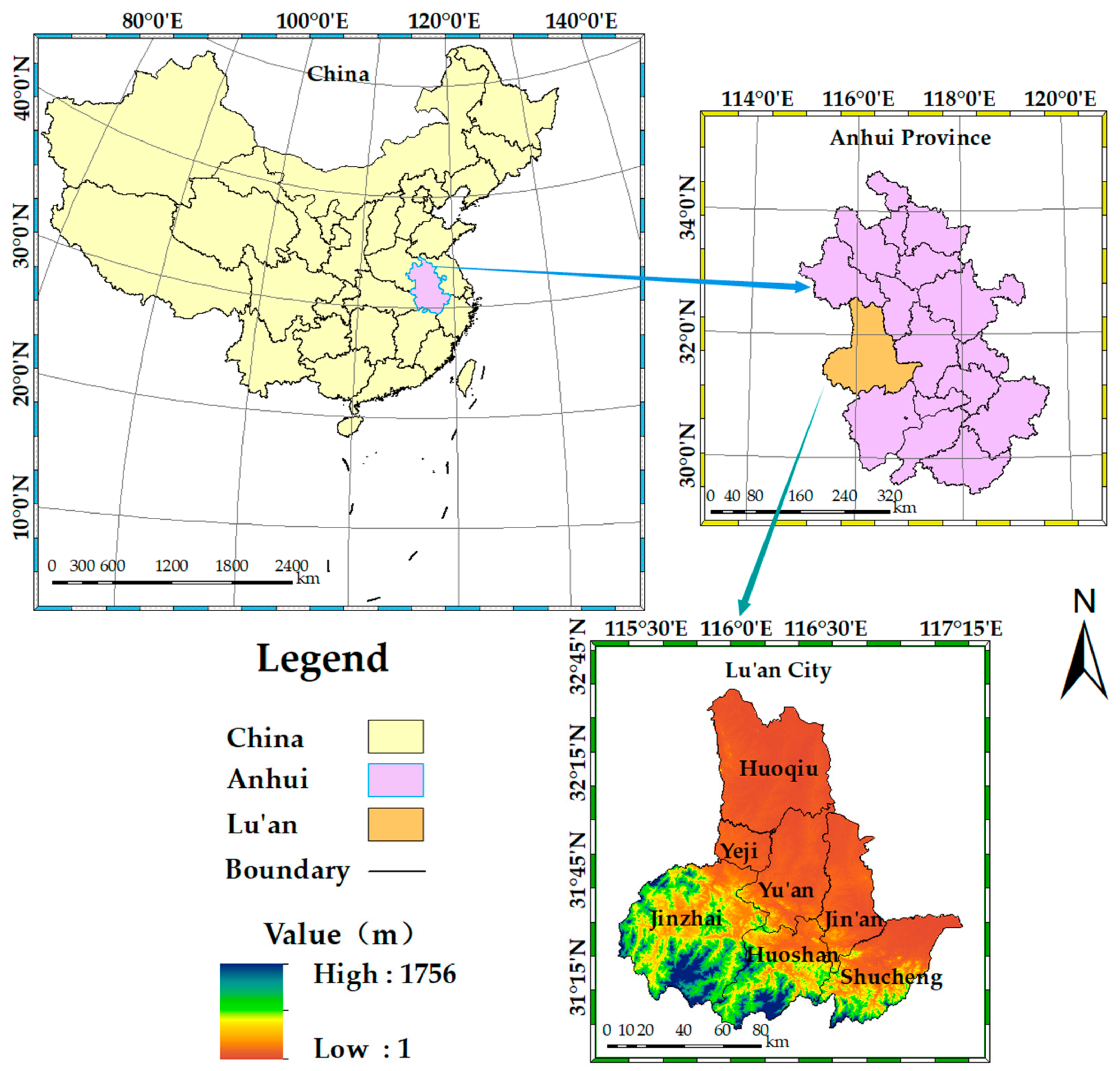
2.1. Study Area
2.2. Data Source and Preprocessing
2.3. Methods
2.3.1. Land Use Transfer
2.3.2. InVEST Model and HQ Model
- (1)
- Evaluation principle of habitat degradation degree
- (2)
- The principle of HQ evaluation
2.3.3. Kendall Rank Correlation Analysis Method
2.3.4. Analysis of Factors Affecting HQ
- (1)
- Standardization
- (2)
- Spearman Rank Correlation Analysis Method
2.3.5. CA-Markov Model
2.3.6. Fieldwork Method
3. Results
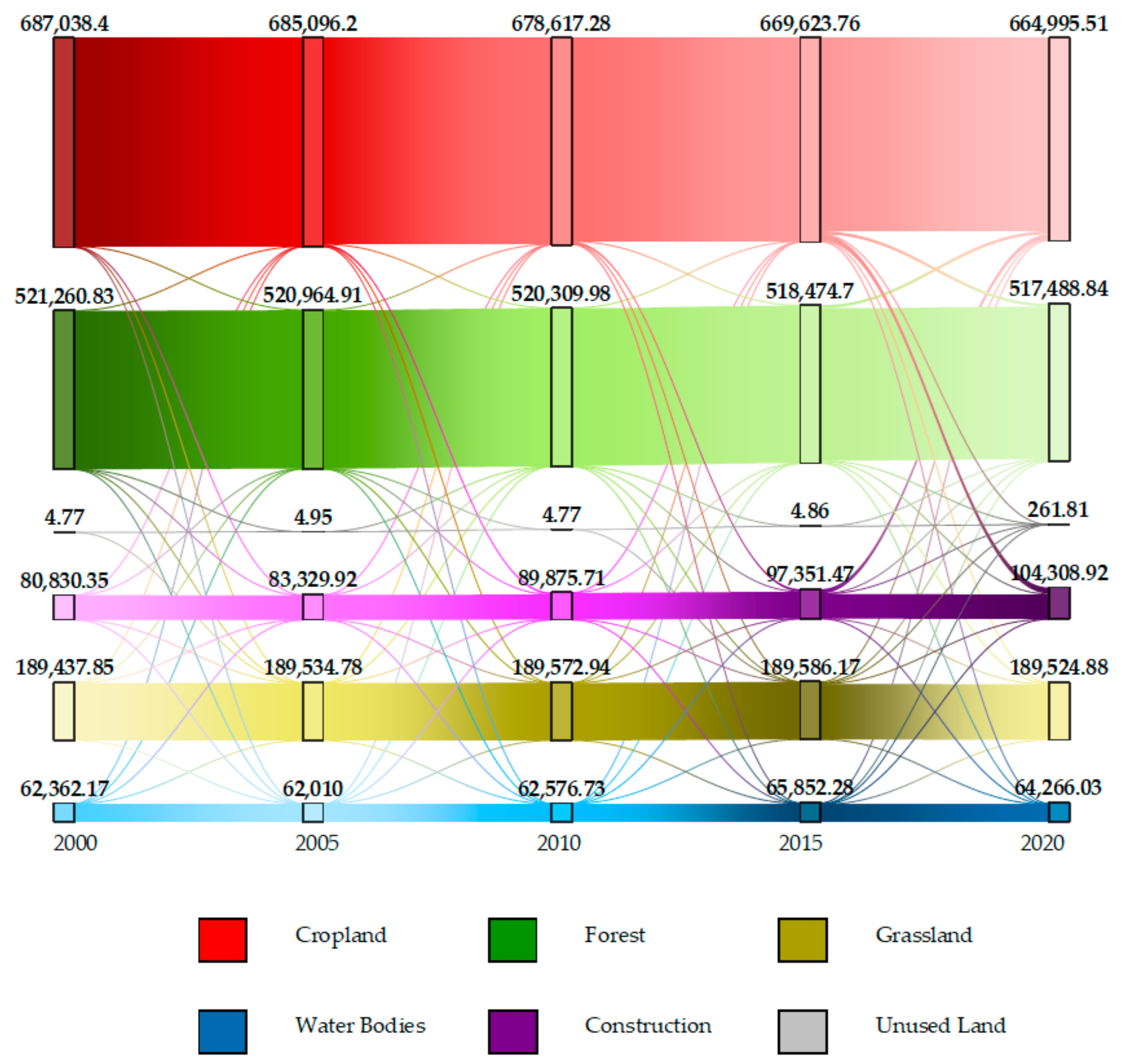
3.1. Dynamic Evolution of LULC in Lu’an City
3.1.1. Spatio-Temporal Dynamic Evolution of Land Use
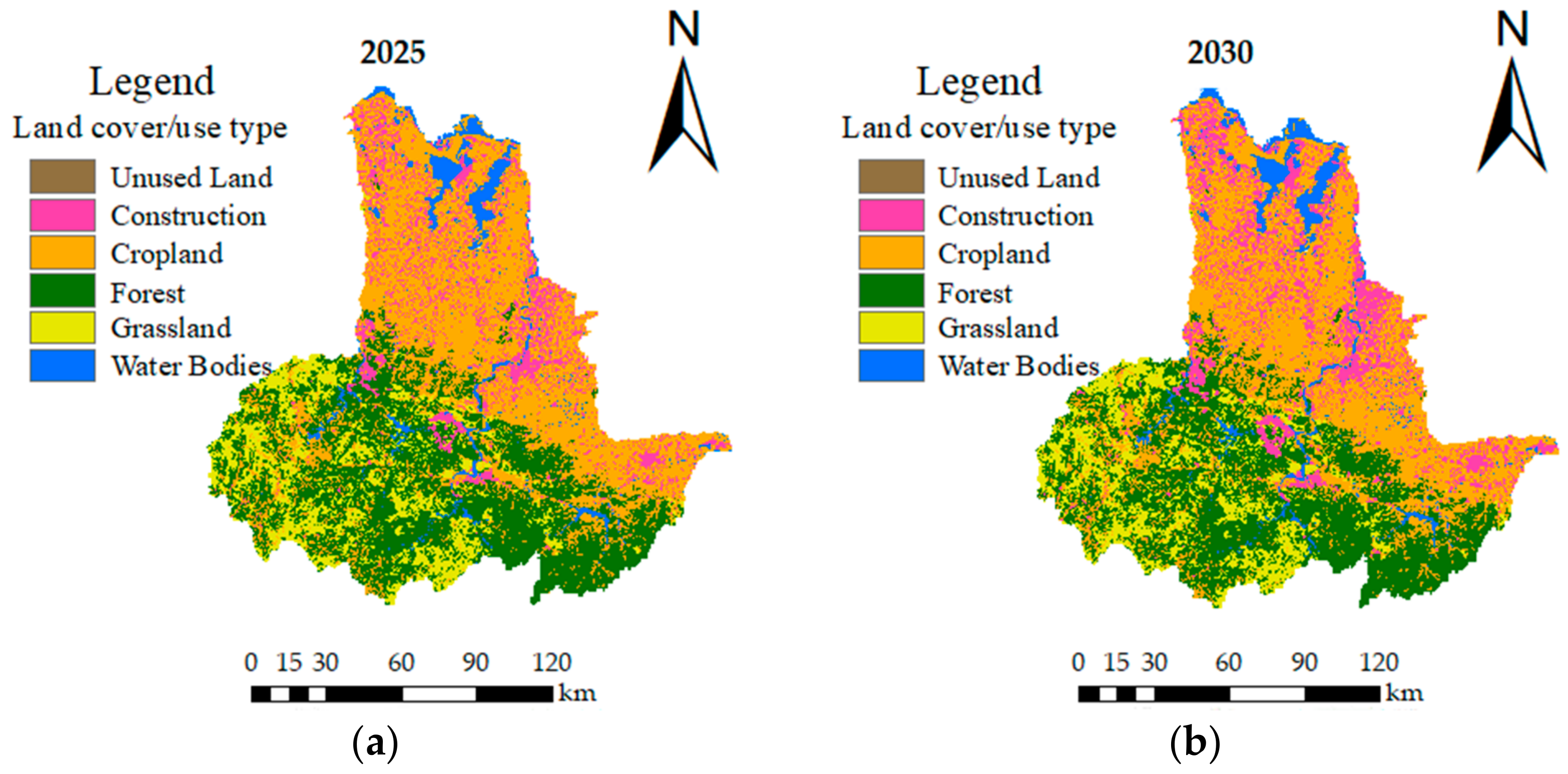
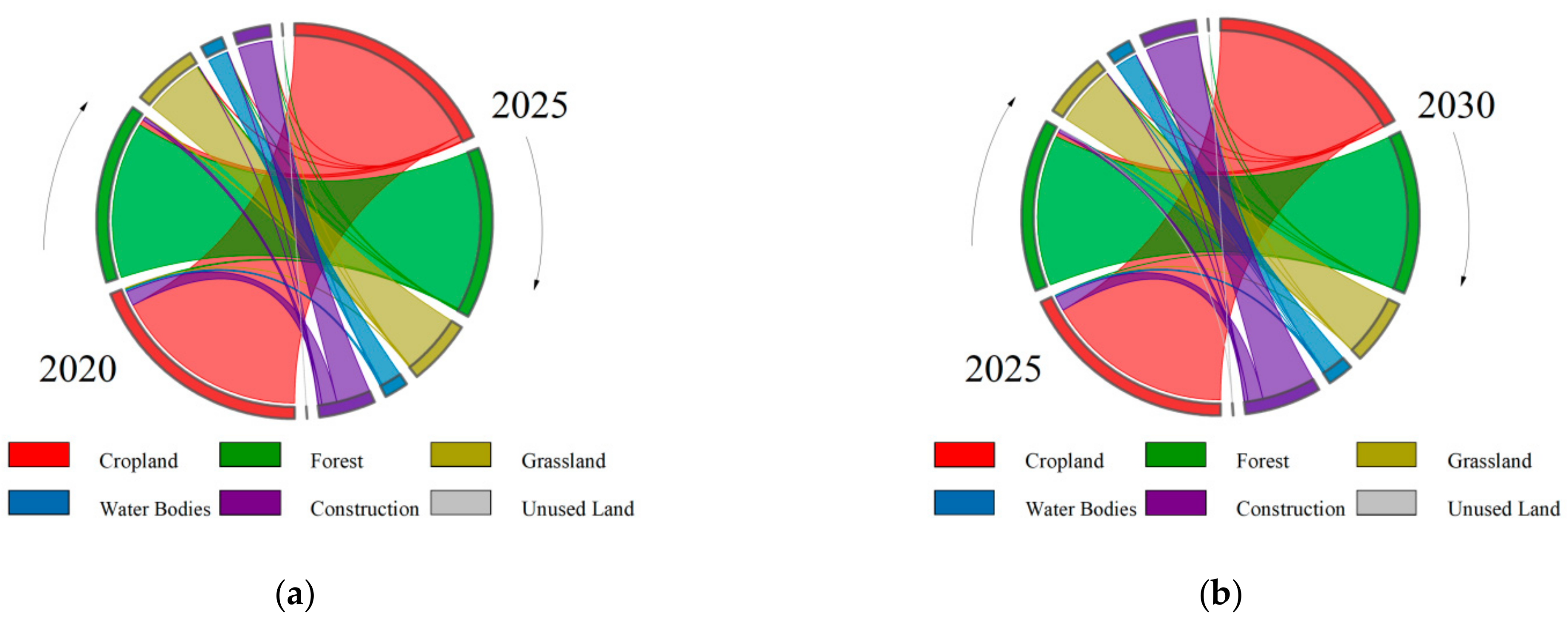
3.1.2. Prediction of Land Use/Land Cover Change (LUCC)
- (1)
- Validation
- (2)
- Prediction
3.2. Spatio-Temporal Differentiation and Prediction of Habitat Degradation Degree and HQ
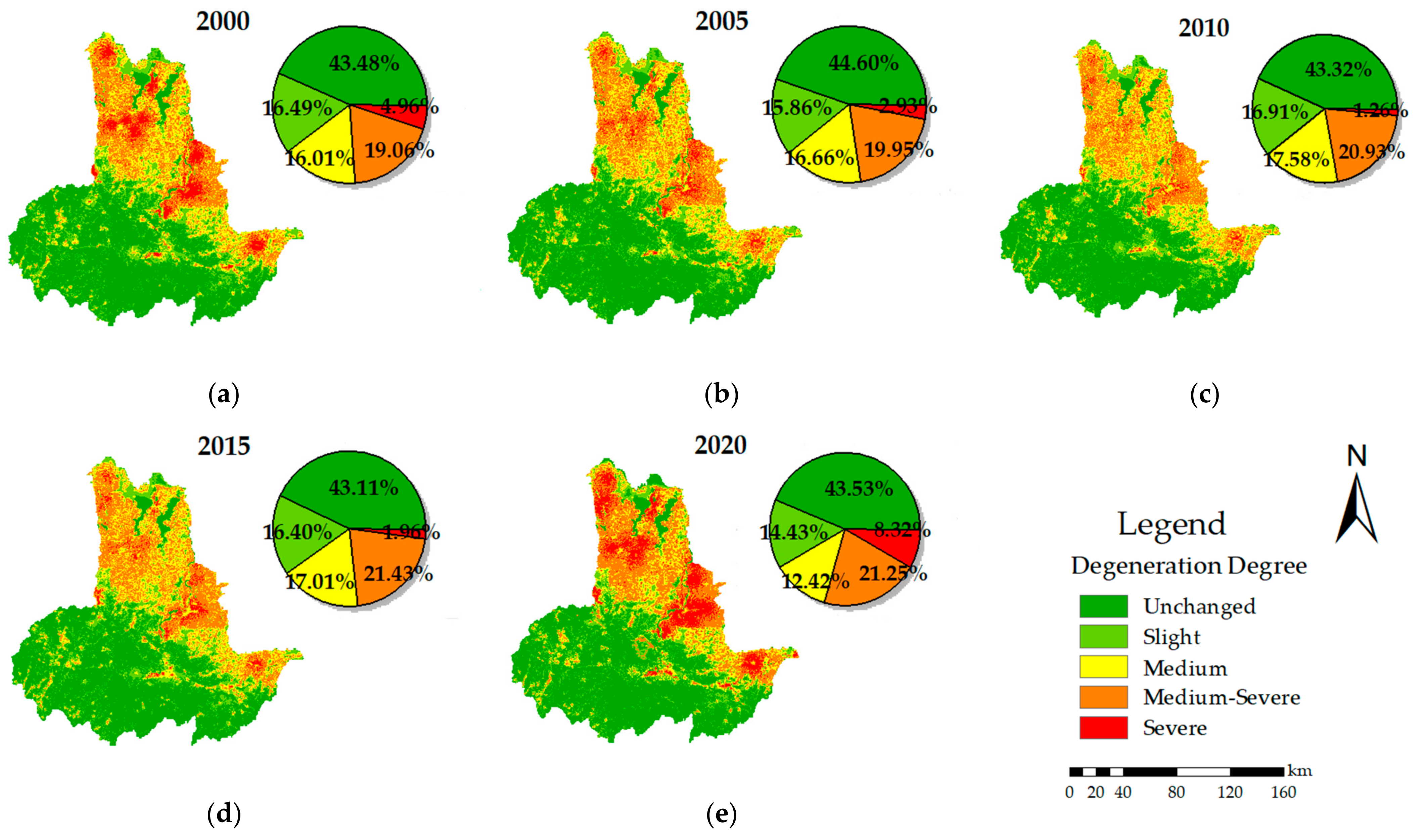
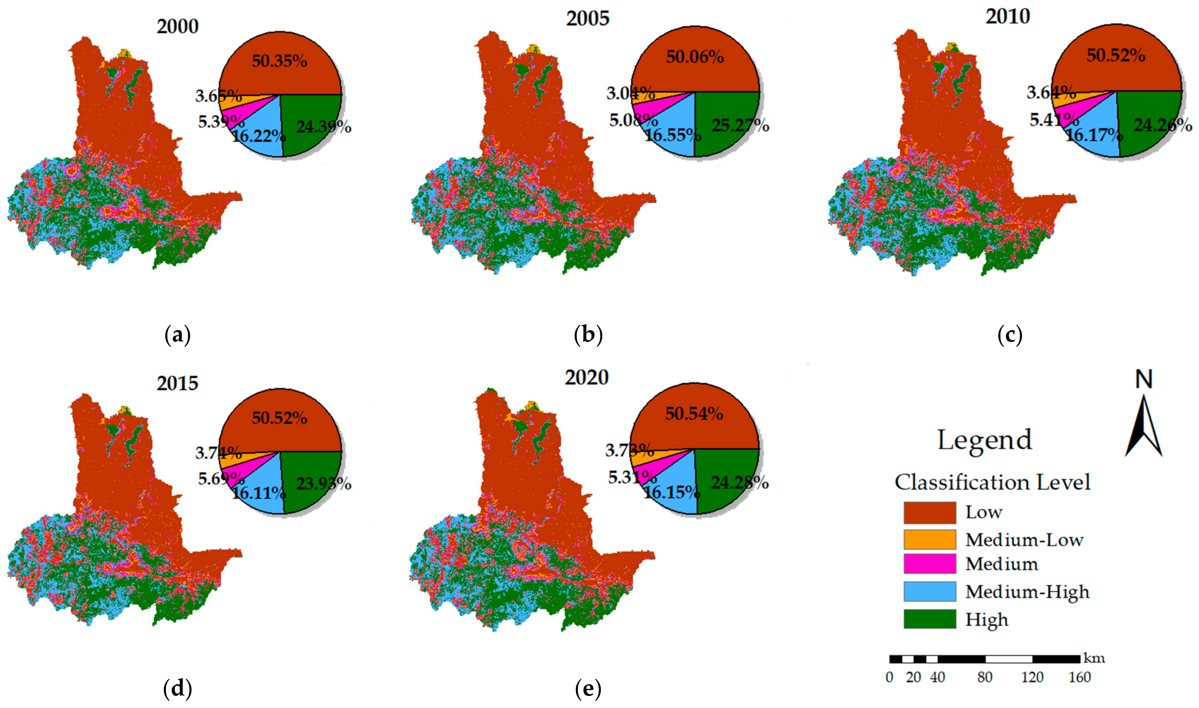
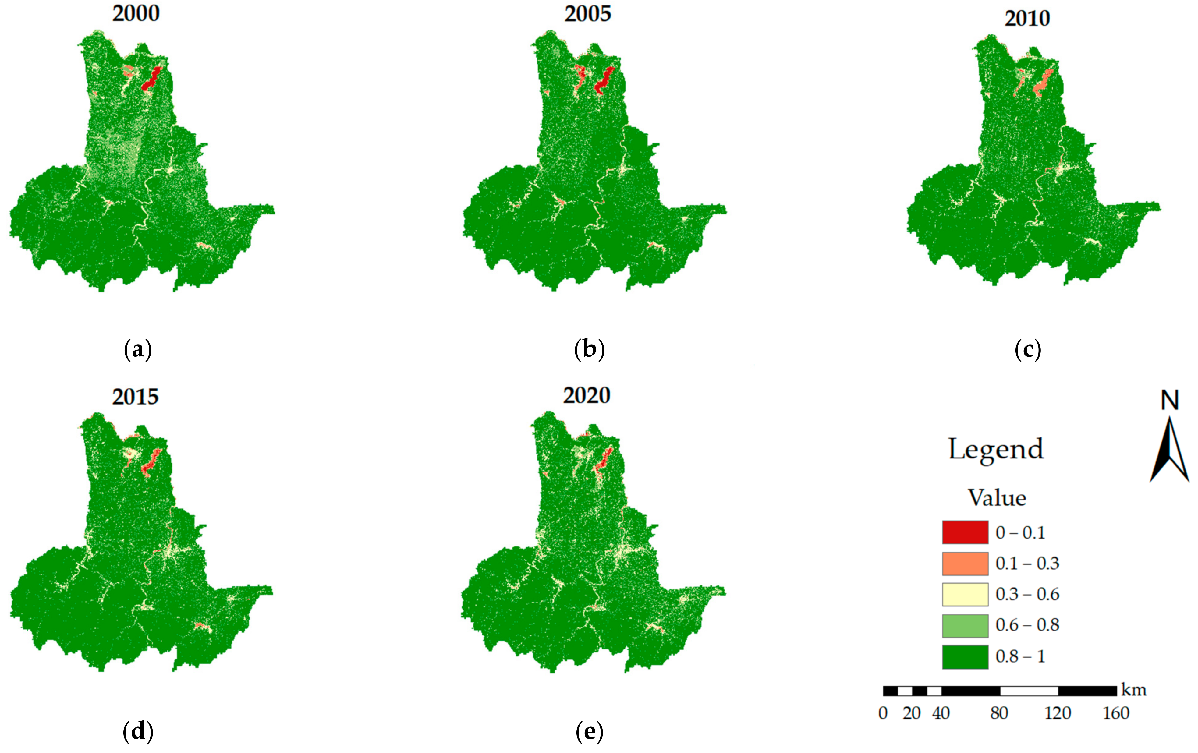
3.2.1. Spatio-Temporal Differentiation
- (1)
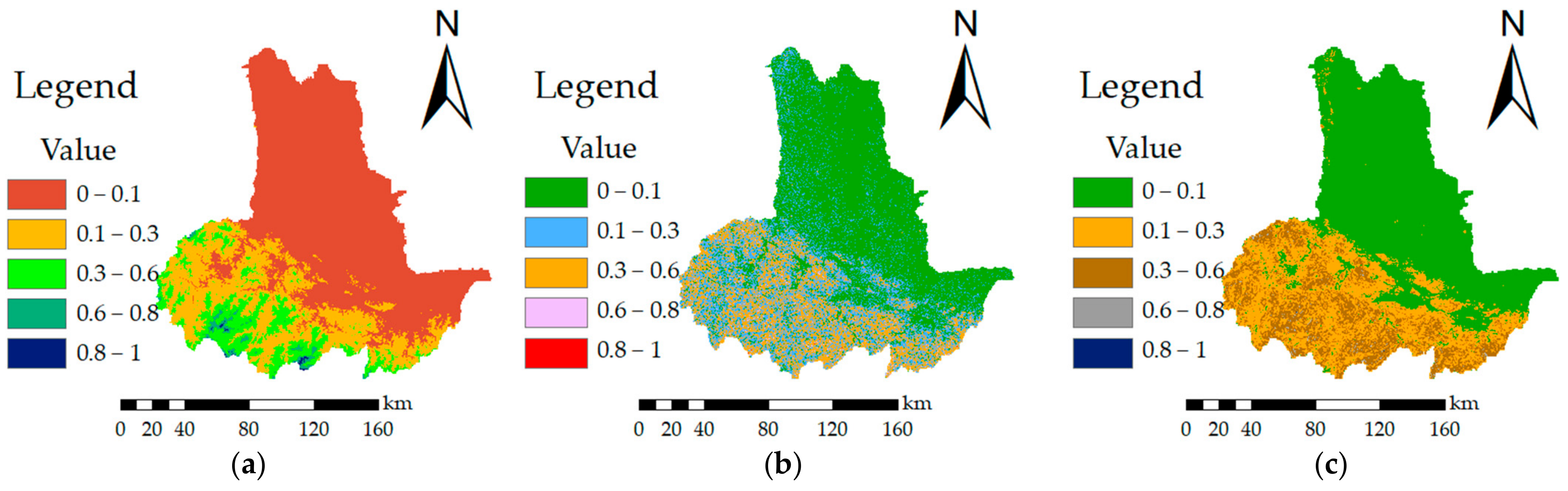
- Habitat Degradation Degree
- (2)
- Habitat Quality (HQ)
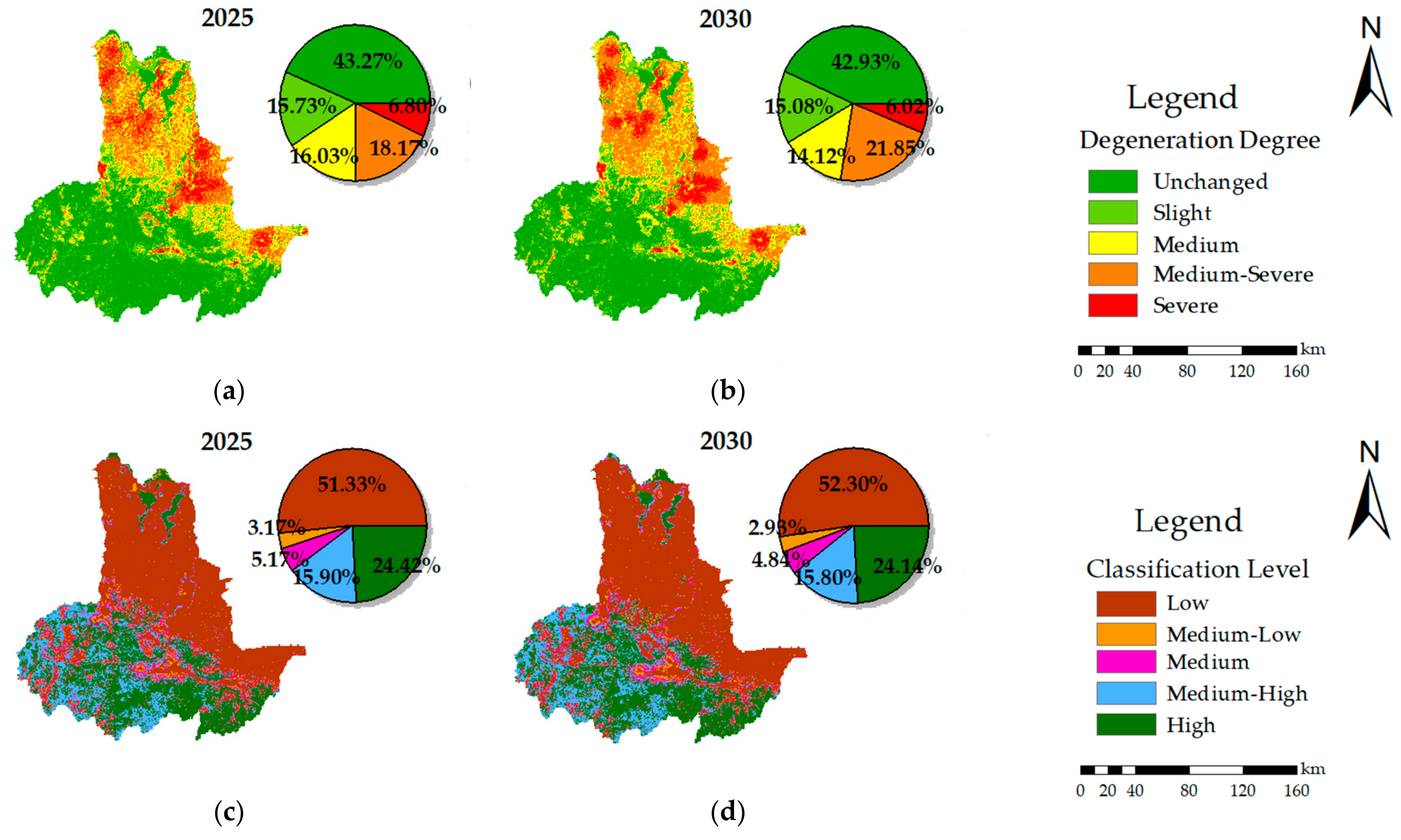
3.2.2. Prediction
4. Discussion
4.1. Correlation Analysis of HQ and Driving Factors in Lu’an City
4.2. The Role of Policies in LULC and HQ Governance
5. Conclusions
Supplementary Materials
Author Contributions
Funding
Data Availability Statement
Conflicts of Interest
References
- Pascual, U.; Balvanera, P.; Anderson, C.B.; Chaplin-Kramer, R.; Christie, M.; Gonzalez-Jimenez, D.; Martin, A.; Raymond, C.M.; Termansen, M.; Vatn, A.; et al. Diverse values of nature for sustainability. Nature 2023, 620, 813. [Google Scholar] [CrossRef] [PubMed]
- Chen, D.; Liu, R.; Zhou, M. Delineation of Urban Growth Boundary Based on Habitat Quality and Carbon Storage: A Case Study of Weiyuan County in Gansu, China. Land 2023, 12, 1006. [Google Scholar] [CrossRef]
- Goldstein, J.H.; Caldarone, G.; Duarte, T.K.; Ennaanay, D.; Hannahs, N.; Mendoza, G.; Polasky, S.; Wolny, S.; Daily, G.C. Integrating ecosystem-service tradeoffs into land-use decisions. Proc. Natl. Acad. Sci. USA 2012, 109, 7565–7570. [Google Scholar] [CrossRef] [PubMed]
- Hall, L.S.; Krausman, P.R.; Morrison, M.L. The habitat concept and a plea for standard terminology. Wildl. Soc. Bull. 1997, 25, 173–182. [Google Scholar]
- Jin, H.; Tian, H.; Zhang, X.; Bi, R.; Lv, C. Spatial and temporal evolution of habitat quality and its driving mechanism in Huang19 County, Shanxi Province. Yellow River 2022, 44, 89–94. [Google Scholar]
- Zhu, C.; Zhang, X.; Zhou, M.; He, S.; Gan, M.; Yang, L.; Wang, K. Impacts of urbanization and landscape pattern on habitat quality using OLS and GWR models in Hangzhou, China. Ecol. Indic. 2020, 117, 106654. [Google Scholar] [CrossRef]
- Zhao, Q.; Shao, J. Evaluating the impact of simulated land use changes under multiple scenarios on ecosystem services in Ji’an, China. Ecol. Indic. 2023, 156, 111040. [Google Scholar] [CrossRef]
- Li, S.; Liu, J.; Lin, J.; Fan, S. Temporal and spatial evolution of habitat quality in Fujian Province based on land use change from 1980 to 2018. Chin. J. Appl. Ecol. 2020, 31, 4080–4090. [Google Scholar]
- Fu, B.; Wang, X.; Feng, X. National Ecological Barrier Area Ecosystem Assessment; Science Press: Beijing, China, 2017. [Google Scholar]
- Dai, L.; Li, S.; Lewis, B.J.; Wu, J.; Yu, D.; Zhou, W.; Zhou, L.; Wu, S. The influence of land use change on the spatial-temporal variability of habitat quality between 1990 and 2010 in Northeast China. J. Res. 2019, 30, 2227–2236. [Google Scholar] [CrossRef]
- Tian, J.; Du, Z.; Jia, Q.; He, L. Spatial differentiation of habitat quality with different topographic gradients and its influencing factors in Taihang Mountain: A case study of Fuping County, Hebei Province. For. Ecol. Sci. 2022, 37, 426–436. [Google Scholar]
- Aizizi, Y.; Kasimu, A.; Liang, H.; Zhang, X.; Zhao, Y.; Wei, B. Evaluation of ecological space and ecological quality changes in urban agglomeration on the northern slope of the Tianshan Mountains. Ecol. Indic. 2023, 146, 109896. [Google Scholar] [CrossRef]
- Lei, J.; Chen, Y.; Li, L.; Chen, Z.; Chen, X.; Wu, T.; Li, Y. Spatiotemporal change of habitat quality in Hainan Island of China based on changes in land use. Ecol. Indic. 2022, 145, 109707. [Google Scholar] [CrossRef]
- Lohse, K.A.; Newburn, D.A.; Opperman, J.J.; Merenlender, A.M. Forecasting relative impacts of land use on anadromous fish habitat to guide conservation planning. Ecol. Appl. 2008, 18, 467–482. [Google Scholar] [CrossRef] [PubMed]
- Wang, Q.; Guan, Q.; Lin, J.; Luo, H.; Tan, Z.; Ma, Y. Simulating land use/land cover change in an arid region with the coupling models. Ecol. Indic. 2021, 122, 107231. [Google Scholar] [CrossRef]
- Li, C.; Wu, Y.; Gao, B.; Zheng, K.; Wu, Y.; Li, C. Multi-scenario simulation of ecosystem service value for optimization of land use in the Sichuan-Yunnan ecological barrier, China. Ecol. Indic. 2021, 132, 108328. [Google Scholar] [CrossRef]
- Riccioli, F.; Asmar, T.E.; Asmar, J.E.; Fratini, R. Use of cellular automata in the study of variables involved in land use changes. Environ. Monit. Assess. 2013, 185, 5361–5374. [Google Scholar] [CrossRef] [PubMed]
- Dongjie, G.; Weijun, G.; Kazuyuki, W.; Hidetoshi, F. Land use change of Kitakyushu based on landscape ecology and Markov model. J. Geogr. Sci. 2008, 18, 455–468. [Google Scholar]
- Xing, X.; Liu, Y.; Jin, R.; Zhang, P.; Tong, S.; Zhu, W. Major Role of Natural Wetland Loss in the Decline of Wetland Habitat Quality-Spatio-Temporal Monitoring and Predictive Analysis. Sustainability 2023, 15, 12415. [Google Scholar] [CrossRef]
- Jiao, Y.; Cheng, W. Study on the impact of land consolidation on habitat quality based on InVEST model. Territ. Nat. Resour. Study 2019, 39–42. [Google Scholar] [CrossRef]
- Meneses, B.M.; Reis, R.; Vale, M.J.; Saraiva, R. Land use and land cover changes in Zezere watershed (Portugal)—Water quality implications. Sci. Total Environ. 2015, 527, 439–447. [Google Scholar] [CrossRef]
- Wang, Y.; Gao, J.; Jin, Y.; Cao, B.; Wang, Y.; Zhang, X.; Zhou, J. Study on habitat quality in the agro-pastoral ecotone of Balin Youqi, Inner Mongolia based on land use change and InVEST model from 2005 to 2015. J. Ecol. Rural. Environ. 2020, 36, 654–662. [Google Scholar]
- Zhong, L.; Wang, J. Evaluation on effect of land consolidation on habitat quality based on InVEST model. Trans. Chin. Soc. Agric. Eng. 2017, 33, 250–255. [Google Scholar]
- Liu, H.; Cai, Y.; Yu, M.; Gong, L.; An, S. Evaluation of river habitat quality in Yixing slice of Taihu Basin. J. Ecol. 2012, 31, 1288–1295. [Google Scholar]
- Reis, E.; Lopez-Iborra, G.M.; Pinheiro, R.T. Changes in bird species richness through different levels of urbanization: Implications for biodiversity conservation and garden design in Central Brazil. Landsc. Urban Plan. 2012, 107, 31–42. [Google Scholar] [CrossRef]
- Chen, H.; Zhao, Y.; Fu, X.; Wu, G. Temporal and spatial evolution of habitat quality in the upper reaches of West Liaohe River and its influencing mechanism. Acta Ecol. Sin. 2023, 43, 948–961. [Google Scholar]
- Zheng, Y.; Zhang, J.; Tian, H.; Zhu, H.; Liu, S.; Ding, Y. Spatio-temporal characteristics of habitat quality and the driving mechanism of natural and human factors in Dabie Mountain region. Environ. Sci. 2023, 1–17. [Google Scholar] [CrossRef]
- Zhou, J.; Song, J.J.; Bai, Q.L.; Liu, C.Y.; Zhang, Z.P.; Tang, H.T. Habitat suitability of Scapharca subcrenata (Lischke) in the shallow water of the Xiaoheishan Island. Hai Yang Xue Bao 2016, 35, 51–57. [Google Scholar] [CrossRef]
- Moreira, M.; Fonseca, C.; Vergílio, M.; Calado, H.; Gil, A. Spatial assessment assessment of habitat conservation status in a Macaronesian island based on the InVEST model: A case study of Pico Island (Azores, Portugal). Land Use Policy 2018, 78, 637–649. [Google Scholar] [CrossRef]
- Larson, M.A.; Thompson, F.R.; Millspaugh, J.J.; Dijak, W.D.; Shifley, S.R. Linking population viability, habitat suitability, and landscape simulation models for conservation planning. Ecol. Modell. 2004, 180, 103–118. [Google Scholar] [CrossRef]
- Li, G.; Liu, C.; Liu, Y.; Yang, J.; Zhang, X.; Guo, K. Research progress of species distribution model theory. Acta Ecol. Sin. 2013, 33, 4827–4835. [Google Scholar]
- Cong, W.; Sun, X.; Guo, H.; Shan, R. Comparison of the SWAT and InVEST models to determine hydrological ecosystem service spatial patterns, priorities and trade-offs in a complex basin. Ecol. Indic. 2020, 112, 106089. [Google Scholar] [CrossRef]
- Sun, X.; Jiang, Z.; Liu, F.; Zhang, D. Monitoring spatio-temporal dynamics of habitat quality in Nansihu Lake basin, eastern China, from 1980 to 2015. Ecol. Indic. 2019, 102, 716–723. [Google Scholar] [CrossRef]
- Xu, H.; Dong, B.; Gao, X.; Xu, Z.; Ren, C.; Fang, L.; Wei, Z.; Liu, X.; Lu, Z. Habitat quality assessment of wintering migratory birds in Poyang Lake National Nature Reserve based on InVEST model. Environ. Sci. Pollut. Res. Int. 2023, 30, 28847–28862. [Google Scholar] [CrossRef] [PubMed]
- Yu, D.; Liu, Y.; Xie, D.; Mu, C.; Sun, Z.; Zhou, M.; Rao, J.; Suolang, D.; Xiong, Y.; Chen, J. Effects of driving factors on water supply function under different basins and spatial scale in Zoige alpine wetland, China. Ecol. Indic. 2024, 158, 111403. [Google Scholar] [CrossRef]
- Xu, J.; Jiang, X.; Liu, H.; Yin, F.; Xu, Y.; Gao, C. Monitoring of spatiotemporal changes in ecosystem service functions and analysis of influencing factors in Pingtan Island. Ecol. Indic. 2024, 158, 111590. [Google Scholar] [CrossRef]
- Wang, X.; Su, F.; Yan, F.; Zhang, X.; Wang, X. Effects of Coastal Urbanization on Habitat Quality: A Case Study in Guangdong-Hong Kong-Macao Greater Bay Area. Land 2023, 12, 34. [Google Scholar] [CrossRef]
- Wu, L.; Sun, C.; Fan, F. Estimating the Characteristic Spatiotemporal Variation in Habitat Quality Using the InVEST Model-A Case Study from Guangdong-Hong Kong-Macao Greater Bay Area. Remote Sens. 2021, 13, 1008. [Google Scholar] [CrossRef]
- Bai, Y.; Ochuodho, T.O.; Yang, J. Impact of land use and climate change on water-related ecosystem services in Kentucky, USA. Ecol. Indic. 2019, 102, 51–64. [Google Scholar] [CrossRef]
- Aneseyee, A.B.; Noszczyk, T.; Soromessa, T.; Elias, E. The InVEST Habitat Quality Model Associated with Land Use/Cover Changes: A Qualitative Case Study of the Winike Watershed in the Omo-Gibe Basin, Southwest Ethiopia. Remote Sens. 2020, 12, 1103. [Google Scholar] [CrossRef]
- Pu, J.; Shen, A.; Liu, C.; Wen, B. Impacts of ecological land fragmentation on habitat quality in the Taihu Lake basin in Jiangsu Province, China. Ecol. Indic. 2024, 158, 111611. [Google Scholar] [CrossRef]
- Chen, M.; Bai, Z.; Wang, Q.; Shi, Z. Habitat Quality Effect and Driving Mechanism of Land Use Transitions: A Case Study of Henan Water Source Area of the Middle Route of the South-to-North Water Transfer Project. Land 2021, 10, 796. [Google Scholar] [CrossRef]
- Yan, K.; Gao, S.; Chi, H.; Qi, J.; Song, W.; Tong, Y.; Mu, X.; Yan, G. Evaluation of the Vegetation-Index-Based Dimidiate Pixel Model for Fractional Vegetation Cover Estimation. IEEE Trans. Geosci. Remote Sens. 2022, 60, 1–14. [Google Scholar] [CrossRef]
- Cai, Y.F.; Zhang, F.; Duan, P.; Jim, C.Y.; Chan, N.W.; Shi, J.C.; Liu, C.J.; Wang, J.G.; Bahtebay, J.; Ma, X. Vegetation cover changes in China induced by ecological restoration-protection projects and land-use changes from 2000 to 2020. Catena 2022, 217, 106530. [Google Scholar] [CrossRef]
- Ma, T.; Liu, R.; Li, Z.; Ma, T. Research on the Evolution Characteristics and Dynamic Simulation of Habitat Quality in the Southwest Mountainous Urban Agglomeration from 1990 to 2030. Land 2023, 12, 1488. [Google Scholar] [CrossRef]
- Li, Y.; Duo, L.; Zhang, M.; Wu, Z.; Guan, Y. Assessment and Estimation of the Spatial and Temporal Evolution of Landscape Patterns and Their Impact on Habitat Quality in Nanchang, China. Land 2021, 10, 1073. [Google Scholar] [CrossRef]
- Liu, S.; Yu, X.; Li, Q.; Li, H.; Lei, F. Land use change in loess hilly region based on CA-Markov model. J. Agric. Eng. 2010, 26, 297–303. [Google Scholar]
- Huang, C.; Yang, J.; Zhang, W. Research progress of ecosystem service function assessment model. J. Ecol. 2013, 32, 3360–3367. [Google Scholar]
- Silver, J.; Schmitt, R.; Sharp, R.; Shaw, R. The Natural Capital Project. In VEST3.14.1. User’s Guide; Stanford University: Stanford, CA, USA, 2024. [Google Scholar]
- Zhao, Q.; Wu, X. Research on the impact of land use change on habitat quality in Minjiang river basin based on InVEST Model. Ecol. Sci. 2022, 41, 1–10. [Google Scholar]
- Mengist, W.; Soromessa, T.; Feyisa, G.L. Landscape change effects on habitat quality in a forest biosphere reserve: Implications for the conservation of native habitats. J. Clean. Prod. 2021, 329, 129778. [Google Scholar] [CrossRef]
- Wang, Z.J.; Liu, S.J.; Su, Y. Spatiotemporal evolution of habitat quality and its response to landscape patterns in karst mountainous cities: A case study of Guiyang City in China. Environ. Sci. Pollut. Res. Int. 2023, 30, 114391–114405. [Google Scholar] [CrossRef]
- Wu, Z.; Zhou, R.; Zeng, Z. Identifying and Mapping the Responses of Ecosystem Services to Land Use Change in Rapidly Urbanizing Regions: A Case Study in Foshan City, China. Remote Sens. 2021, 13, 4374. [Google Scholar] [CrossRef]
- Zou, Y.; Meng, J.; Zhu, L.; Han, Z.; Ma, Y. Characterizing land use transition in China by accounting for the conflicts underlying land use structure and function. J. Environ. Manag. 2024, 349, 119311. [Google Scholar] [CrossRef]
- Huang, M.; Yue, W.; Feng, S.; Zhang, J. Spatio-temporal evolution and landscape pattern analysis of habitat quality in Dabie Mountain area of west Anhui Province based on InVEST model. Acta Ecol. Sin. 2020, 40, 2895–2906. [Google Scholar]
- Chu, L.; Zhang, X.; Wang, T.; Li, Z.; Cai, C. Spatial-temporal evolution and prediction of urban landscape pattern and habitat quality based on CA-Markov and InVEST models. Chin. J. Appl. Ecol. 2018, 29, 4106–4118. [Google Scholar]
- Duan, H.; Yu, X. Land-Use Change, Habitat Connectivity, and Conservation Gaps: A Case Study of Shorebird Species in the Yellow River Delta of China Using the InVEST Model and Network Analysis. Remote Sens. 2022, 14, 6191. [Google Scholar] [CrossRef]
- Zhang, X.; Song, W.; Lang, Y.; Feng, X.; Yuan, Q.; Wang, J. Land use changes in the coastal zone of China’s Hebei Province and the corresponding impacts on habitat quality. Land Use Policy 2020, 99, 104957. [Google Scholar] [CrossRef]
- de Winter, J.; Gosling, S.D.; Potter, J. Comparing the Pearson and Spearman Correlation Coefficients Across Distributions and Sample Sizes: A Tutorial Using Simulations and Empirical Data. Psychol. Methods 2016, 21, 273–290. [Google Scholar] [CrossRef] [PubMed]
- Hauke, J.; Tomasz, K. Comparison of Values of Pearson’s and Spearman’s Correlation Coefficients on the Same Sets of Data. Quaest. Geogr. 2011, 30, 87–93. [Google Scholar] [CrossRef]
- Wu, S.S.; Fu, Y.L.; Shen, H.; Liu, F. Using ranked weights and Shannon entropy to modify regional sustainable society index. Sustain. Cities Soc. 2018, 41, 443–448. [Google Scholar] [CrossRef]
- Zhang, H.; Wang, F.; Zhao, H.; Kang, P.; Tang, L. Evolution of habitat quality and analysis of influencing factors in the Yellow River Delta Wetland from 1986 to 2020. Front. Ecol. Evol. 2022, 10, 1075914. [Google Scholar] [CrossRef]
- Zhu, L.; Song, R.; Sun, S.; Li, Y.; Hu, K. Land use/land cover change and its impact on ecosystem carbon storage in coastal areas of China from 1980 to 2050. Ecol. Indic. 2022, 142, 109178. [Google Scholar] [CrossRef]
- Dammag, A.Q.; Jian, D.; Cong, G.; Derhem, B.Q.; Latif, H.Z. Predicting spatio-temporal land use/land cover changes and their drivers forces based on a cellular automated Markov model in Ibb City, Yemen. Geocarto Int. 2023, 38, 2268059. [Google Scholar] [CrossRef]
- Selmy, S.; Kucher, D.E.; Mozgeris, G.; Moursy, A.; Jimenez-Ballesta, R.; Kucher, O.D.; Fadl, M.E.; Mustafa, A. Detecting, Analyzing, and Predicting Land Use/Land Cover (LULC) Changes in Arid Regions Using Landsat Images, CA-Markov Hybrid Model, and GIS Techniques. Remote Sens. 2023, 15, 5522. [Google Scholar] [CrossRef]
- Xie, L.; Chen, Z.; Jiang, Y.; Xiao, X.; Jia, Y. Study on habitat quality changes and influencing factors of Huixian Wetland based on InVEST&GEO-detectors model. J. Guangxi Norm. Univ. 2023, 41, 180–190. [Google Scholar]
- Grossman, G.M.; Krueger, A.B. Environmental Impacts of a North American Free Trade Agreement; National Bureau of Economic Research Working Paper Series No. 3914; Massachusetts Institute of Technology Press: Cambridge, MA, USA, 1991. [Google Scholar]
- Liu, L.; Wu, Y.; Han, Z.; Jiang, X. The influence of forestry ecological construction attention on environmental Kuznets curve. For. Eng. 2023, 39, 64–74. [Google Scholar]
- Liu, Y.; Huang, X.; Yang, H. An integrated approach to investigate the coupling coordination between urbanization and flood disasters in China. J. Clean. Prod. 2022, 375, 134191. [Google Scholar] [CrossRef]
- Carmona, P.; Stef, N.; Ben Jabeur, S.; Ben Zaied, Y. Climate change and government policy: Fresh insights from complexity theory. J. Environ. Manag. 2023, 338, 117831. [Google Scholar] [CrossRef] [PubMed]
- Stef, N.; Ben Jabeur, S. Elections and Environmental Quality. Environ. Resour. Econ. 2023, 84, 593–625. [Google Scholar] [CrossRef]
- Tang, J.; Zhou, L.; Dang, X.; Hu, F.; Yuan, B.; Yuan, Z.; Wei, L. Impacts and predictions of urban expansion on habitat quality in the densely populated areas: A case study of the Yellow River Basin, China. Ecol. Indic. 2023, 151, 110320. [Google Scholar] [CrossRef]
- Zhang, W.; Wen, L. Research on the analysis of the coupling coordination degree of Shaanxi’s atmospheric ecological governance and urban clean governance based on environmental sustainability. Ecol. Indic. 2023, 155, 111068. [Google Scholar] [CrossRef]
- Kremen, C.; Merenlender, A.M. Landscapes that work for biodiversity and people. Science 2018, 362, eaau6020. [Google Scholar] [CrossRef] [PubMed]
- Han, Q.; Guo, Z.; Kumar, R.; Kumar, A. An empirical approach for enhancing farmers’ concentrated residence strategies: A case study in Jiangsu Province, China. Ecol. Indic. 2024, 158, 111361. [Google Scholar] [CrossRef]
- Almeida, D.; André, M.; Scariot, E.C.; Fushita, A.T.; Dos Santos, J.E.; Bogaert, J. Temporal change of Distance to Nature index for anthropogenic influence monitoring in a protected area and its buffer zone. Ecol. Indic. 2018, 91, 189–194. [Google Scholar] [CrossRef]
- Wang, H.; Liu, X.; Zhao, C.; Chang, Y.; Liu, Y.; Zang, F. Spatial-temporal pattern analysis of landscape ecological risk assessment based on land use/land cover change in Baishuijiang National nature reserve in Gansu Province, China. Ecol. Indic. 2021, 124, 107454. [Google Scholar] [CrossRef]
- De Marco Jr, P.; de Souza, R.A.; Andrade, A.F.A. The value of private properties for the conservation of biodiversity in the Brazilian Cerrado. Science 2023, 380, 298–301. [Google Scholar] [CrossRef]
- Kendall Correlation Coefficient Overview and Python Calculation Examples. Available online: https://blog.csdn.net/chenxy_bwave/article/details/126919019 (accessed on 30 March 2024).
- Li, K.; Zhang, B. Land use simulation and prediction of Loess Plateau based on CA-Markov model. Hubei Agric. Sci. 2022, 61, 64–69. [Google Scholar]


| LT | CRO | FOR | GRA | WB | CON | UNL |
|---|---|---|---|---|---|---|
| HS | 0.35 | 1 | 0.75 | 0.9 | 0 | 0.15 |
| Threat | MD/km | Weight | DT |
|---|---|---|---|
| PF | 0.5 | 0.3 | exponential |
| DL | 0.5 | 0.3 | exponential |
| UL | 8 | 0.9 | exponential |
| RSL | 2 | 0.7 | exponential |
| OCL | 1 | 0.5 | exponential |
| UNL | 3 | 0.4 | linear |
| LT | Cropland | Forest | Grassland | Water Bodies | Construction | Unused Land | ||
|---|---|---|---|---|---|---|---|---|
| V | ||||||||
| A | ||||||||
| 2020–2025 | −5.41% | −4.88% | −0.33% | 7.51% | 54.69% | −3.23% | ||
| 2025–2030 | −5.72% | −5.18% | −0.36% | 7.47% | 35.34% | 0.00 | ||
| Year | Driving Factors | |||||
|---|---|---|---|---|---|---|
| SLO | TRI | DEM | FVC | HFI | GDP | |
| 2000 | 0.595 ** | 0.680 ** | 0.704 ** | 0.426 ** | −0.679 ** | −0.441 ** |
| 2005 | 0.582 ** | 0.664 ** | 0.686 ** | 0.331 ** | −0.664 ** | −0.333 ** |
| 2010 | 0.606 ** | 0.692 ** | 0.720 ** | 0.326 ** | −0.697 ** | −0.387 ** |
| 2015 | 0.610 ** | 0.686 ** | 0.707 ** | 0.322 ** | −0.694 ** | −0.319 ** |
| 2020 | 0.606 ** | 0.681 ** | 0.715 ** | 0.376 ** | −0.703 ** | −0.360 ** |
| Mean | 0.600 | 0.681 | 0.706 | 0.356 | −0.687 | −0.368 |
| Year | Policy | Sources |
|---|---|---|
| 2000 | Several opinions of the State Council on Further Improving the Pilot Work of Returning Cropland to Forests and Grasslands | https://www.gov.cn/gongbao/content/2000/content_60486.htm, accessed on 30 March 2024. |
| 2001 | Natural forest protection project | https://www.forestry.gov.cn/main/5925/20200414/090421585104600.html, accessed on 30 March 2024. |
| 2002 | Several opinions of the State Council on Further improving the policy and measures for returning cropland to forest | https://www.gov.cn/gongbao/content/2002/content_61463.htm, accessed on 30 March 2024. |
| 2002 | Regulations on returning cropland to forest | https://www.gov.cn/gongbao/content/2003/content_62531.htm, accessed on 30 March 2024. |
| 2010 | Notice on the issuance of Shucheng County to accelerate the Wanjiang City Belt to undertake industrial transfer Demonstration Zone Construction Planning | https://www.shucheng.gov.cn/public/6598641/34717434.html, accessed on 24 January 2024. |
| 2012 | Overall plan of Anhui Province’s 10 million mu Forest Growth Project (2012–2016) | http://district.ce.cn/zt/zlk/bg/201210/23/t20121023_23780196.shtml, accessed on 30 March 2024. |
| 2012 | Opinions of the People’s Government of Anhui Province on implementing the 10 million mu Forest Growth Project and promoting the construction of an ecologically strong province | https://www.ah.gov.cn/szf/zfgb/8118971.html, accessed on 30 March 2024. |
| 2012 | The Green Corridor Project | http://www.lazdgcc.cn/zdgc/gjjptjs/3043091.html, accessed on 29 March 2024. |
| 2017 | Opinions of the People’s Government of Anhui Province on implementing the action of increasing forest area and stock in forestry (Forestry Double Increase) | https://www.ah.gov.cn/szf/zfgb/8118971.html, accessed on 23 January 2024. |
| 2020 | The Leading Group of Hefei Metropolitan Area Construction issued a notice on the Development Plan of the Hefei-Lu’an Economic Corridor (2020–2025) | https://www.ja.gov.cn/public/6599071/21729501.html, accessed on 8 February 2024. |
| 2022 | Lu’an City “14th five-year plan” ecological environmental protection planning | https://www.luan.gov.cn/public/6608171/9901072.html, accessed on 16 October 2023. |
| 2022 | Notice on further improving policies and measures to consolidate the results of returning cropland to forest and grassland | https://www.gov.cn/zhengce/zhengceku/2022-11/11/content_5726119.htm, accessed on 10 October 2023. |
| 2022 | The three-year action plan to accelerate the development of Camellia Oleifera Abel industry | https://www.gov.cn/zhengce/zhengceku/2023-01/10/content_5736075.htm, accessed on 27 March 2024. |
| 2023 | The Master Plan of Land Space of Lu’an City (2021–2035) | https://www.ja.gov.cn/public/6602111/24951309.html, accessed on 15 September 2023. |
Disclaimer/Publisher’s Note: The statements, opinions and data contained in all publications are solely those of the individual author(s) and contributor(s) and not of MDPI and/or the editor(s). MDPI and/or the editor(s) disclaim responsibility for any injury to people or property resulting from any ideas, methods, instructions or products referred to in the content. |
© 2024 by the authors. Licensee MDPI, Basel, Switzerland. This article is an open access article distributed under the terms and conditions of the Creative Commons Attribution (CC BY) license (https://creativecommons.org/licenses/by/4.0/).
Share and Cite
Wang, G.; Zhao, Q.; Jia, W. Spatio-Temporal Differentiation and Driving Factors of Land Use and Habitat Quality in Lu’an City, China. Land 2024, 13, 789. https://doi.org/10.3390/land13060789
Wang G, Zhao Q, Jia W. Spatio-Temporal Differentiation and Driving Factors of Land Use and Habitat Quality in Lu’an City, China. Land. 2024; 13(6):789. https://doi.org/10.3390/land13060789
Chicago/Turabian StyleWang, Guandong, Qingjian Zhao, and Weiguo Jia. 2024. "Spatio-Temporal Differentiation and Driving Factors of Land Use and Habitat Quality in Lu’an City, China" Land 13, no. 6: 789. https://doi.org/10.3390/land13060789
APA StyleWang, G., Zhao, Q., & Jia, W. (2024). Spatio-Temporal Differentiation and Driving Factors of Land Use and Habitat Quality in Lu’an City, China. Land, 13(6), 789. https://doi.org/10.3390/land13060789