Article

Spatial Development and Coupling Coordination of Society–Physics–Informational Smart Cities: A Case Study on Thirty Capitals in China

1
School of Public Policy & Management, China University of Mining and Technology, Xuzhou 221116, China
2
Sun Yueqi College, China University of Mining and Technology, Xuzhou 221116, China
*
Author to whom correspondence should be addressed.
Land 2024, 13(6), 872; https://doi.org/10.3390/land13060872
Submission received: 15 April 2024 / Revised: 30 May 2024 / Accepted: 12 June 2024 / Published: 17 June 2024

Abstract

:
The smart city concept has taken center stage as a paradigm shift in urban governance, promising innovation, sustainability, and strategic upgrades, and drawing the attention of researchers globally. However, existing frameworks for assessing smart cities remain incomplete and simplistic. This paper aims to address the following question: what is the process and current situation of 30 capitals in China after the implementation of smart city construction, especially from the new perspective of social, physical, and informational space development? To this end, we focus on 30 national and provincial capitals in China, proposing a novel, tri-dimensional SPI model—Social, Physical, and Information space—for smart city spatial development assessment. Employing a robust methodological approach, including entropy weighting, coupled coordination degree models, and the Dagum Gini coefficient, we conduct a spatial development and coordination analysis of these cities from 2011 to 2021. In addition, we utilize BP neural networks to evaluate the contribution of each indicator to the spatial coupled coordination. Our findings indicate a steady increase in the spatial coupled coordination development level of smart capitals in China, alongside a narrowing disparity in development speeds across regions, resulting in a staggered spatial distribution pattern. Specifically, the Information space subsystem represents the most influential driver of coupled coordination. The significance of this research lies in its unique tri-dimensional spatial perspective, offering valuable insights into the spatial development and coordination discrepancies in the smart city concept. These insights offer evidence-based support for regional planning and optimization strategies in China.

1. Introduction

The rapid globalization of the 21st century has ushered in unprecedented complexity in the economic, social, and spatial structures of major cities [1]. This urban transformation has given rise to a multitude of challenges, including population expansion, uneven resource distribution, and ecological degradation fueled by urban sprawl. In response, a wave of innovative urban planning concepts has emerged, including digital cities, smart cities, low-carbon cities, resilient design, and knowledge hubs. Among these, the smart city concept stands out, offering unique advantages in resilience building [2], security risk governance [3,4], ecological environment protection [5], and sustainable development. They are regarded as a set of technological solutions for “comprehensive transformation, all-round empowerment, and revolutionary reshaping” of urban governance. Therefore, governments worldwide have embraced the smart city concept, actively pursuing its implementation [6].
Therefore, considering the context of Chinese smart urbanization, this study seeks to address the following question: what is the process and current situation of 30 capitals in China after the implementation of smart city construction, especially from the new perspective of social, physical, and informational space development? Accordingly, to achieve this, we will (1) analyze the structural composition of these 30 smart cities through the theoretical perspective of tri-dimensional space; (2) employ a spatially integrated evaluation system, a modified coupled coordination model, and the Dagum Gini coefficient decomposition method to explore spatiotemporal evolutionary patterns; and (3) present our findings through intuitive visualizations, offering new empirical insights to the smart city research community.
This study makes two significant contributions. First, it introduces a novel framework for understanding the spatial structure of smart cities through the perspective of ternary space. We develop an evaluation index system of ternary space integration (SPI) to systematically assess the developmental progress of 30 smart cities in China. This analysis offers empirical insights into the achievements and structural imbalances that have characterized China’s smart city development over the past decade. Second, by analyzing the coupling coordination of ternary space, we identify key drivers influencing smart city development across different regions. These findings offer valuable guidance for strategic decision-making in the evolution of smart cities in China’s digital era.

2. Materials and Review

2.1. Study Area

This study analyzes and evaluates the urban spatial coupling development level of 30 national and provincial capitals across China. To facilitate our analysis, we divided these cities into four geographical regions: east, northeast, central, and west (Figure 1). As key drivers of smart city development in their respective regions, these cities represent ideal representatives for our research.

2.2. Literature Review

The analysis of urban spaces has long been a focal point for researchers, representing a key paradigm in the field. Early pioneers, such as the Chicago School led by figures such as Georg Simmel in the 1920s, bridged the gap between spatial research and sociology, affecting the development of urban studies [7]. The concept of “smart cities” first appeared at the 1990 International Conference on Smart Communities in San Francisco. This concept gained significant traction globally following IBM’s relevant proposal in 2008, leading to a surge in smart city construction [8]. Developed nations and regions, including the United States, the European Union, Japan, and Singapore, have positioned smart city development as a cornerstone of their future urban planning, actively pursuing innovative approaches to smart urban governance and the integration of digital technology [9,10]. However, as smart city construction progresses, concerns regarding the intricacies of governing these complex environments are surfacing [11]. A longstanding emphasis on technological solutions has inadvertently led to unintended consequences. Issues such as the digital marginalization of certain groups, the exacerbation of existing digital inequalities, the potential for the misuse of citizen data, and violations of privacy [12] have emerged. These challenges expose vulnerabilities in the smart city model, highlighting inefficiencies, disruptions, and imbalances in these technologically advanced urban spaces.
The growing importance of scientifically robust evaluation schemes in cultivating the sustainable development of smart cities is increasingly apparent. This recognition has spurred the development of various tools, frameworks, and indicator sets designed to evaluate smart city [13,14]. Academic research has been instrumental in offering a theoretical foundation for these evaluation systems. Researchers have evaluated the development, value proposition, and strategic choices of smart cities [15,16]. This research comprises areas such as the theoretical underpinnings of smart city development, governance innovation models [17,18], pathways for technological empowerment [19,20], and project planning considerations [21]. In addition, researchers have analyzed practical challenges [22,23], security vulnerabilities [24], and the broader opportunities and obstacles in smart city development [25]. From a practical standpoint, industry leaders have focused on establishing norms and standardized systems to guide smart city construction. For instance, in May 2023, the State Administration for Market Regulation in China released its “New Smart City Evaluation Indicators”. These indicators consist of nine key areas: citizen-centric services, accuracy governance, ecological sustainability, information infrastructure, information resources, industrial advancement, information security, innovative development, and citizen experience. Similarly, numerous international organizations and nations have introduced their own indicator systems. Specific examples include the Smart Sustainable City Development Index (SSCDI) [26], which emphasizes social, economic, environmental, cultural, and quality-of-life dimensions, and the European Smart City Evaluation System, which focuses on the smart economy, smart public services, smart governance, smart mobility, smart environment, and smart living. Complementing these efforts, academic research has produced risk management frameworks prioritizing security [27], NIST privacy frameworks [28], and information security risk assessment indicator systems [29].
The burgeoning field of smart city research, fueled by collaboration between academia and industry, offers a wealth of knowledge and innovative perspectives to drive sustainable urban development. However, a closer look at existing evaluation indicator systems indicates a persistent issue of “systematic fragmentation”. While many of these systems aim for a holistic assessment of smart city progress, they often lack a robust theoretical grounding and a clearly defined structural logic. Therefore, evaluation outcomes, though seemingly comprehensive, lack the necessary structural integrity and correlation to offer truly insightful evidence. This gap presents a compelling opportunity for this study to explore smart city development through the perspective of spatial integration.

3. Methods and Data Sources

3.1. Modeling

The dawn of the 21st century brought with it a wave of innovation in information technology, propelling the expansion and evolution of human living space forms. This digital revolution has ushered in a transition from a two-dimensional understanding of space to a tri-dimensional space [30,31]. In essence, we have transitioned from the traditional “physical–social” space to the coexistence of physical, social, and information space, constituting this new tri-dimensional paradigm and prompting the development of novel spatial theories [32,33].
To address concerns surrounding information development in smart cities and explain its spatiotemporal structure, this study proposes an integrated, tri-dimensional evaluation model. This model (Figure 2) is developed according to a comprehensive literature review and qualitative analysis. Smart cities, as complex and expansive systems, are the product of the coupled coordination of three subsystems: physical space, social space, and information space. The informational space, a virtual network, comprises data, computing power, and algorithms. In contrast, physical space comprises the tangible elements of production, ecology, and daily life. Social space, on the other hand, arises from the interactions of various actors such as government, civil society, and the public, affecting shared attitudes, behaviors, and values. Crucially, these subsystems are not isolated; rather, there is close interaction between each subsystem, forming the “physical–social” subsystem, “information–physical” subsystem, and “physical–social” binary subsystem.

3.2. Construction of the Evaluation Index System

This study evaluates the spatial development level of smart cities across 30 provinces in mainland China (excluding Tibet, Hong Kong, and Macau) from 2011 to 2021, drawing upon available and representative data. Following the State Council’s classification of China’s economic regions, the study divides these cities into four major regions: East, Central, West, and Northeast. The analysis incorporates socioeconomic and statistical indicators primarily sourced from the “China Science and Technology Statistical Yearbook” and the “China Urban Statistical Yearbook” (2012–2020). Additional data are drawn from statistical yearbooks, along with national economic and social development bulletins, published by the 30 provincial capitals and municipalities. The study utilizes the Baidu Index’s public attention index as a measure of network search interest [34], while the digital inclusive finance index is obtained from the “Peking University Digital Inclusive Finance Index Report”. Interpolation methods were utilized to fill in any missing data points in the dataset.

3.2.1. Construction of Evaluation Index System for Informational Space

The informational space subsystem, referred to as the target level in this study, focuses on data as its fundamental element. In this target level, three standardized layer indices are constructed: data, algorithms, and computing power. Drawing upon existing research [35], six tertiary indicators are developed for the information level (Table 1). The data layer is represented by the Peking University Digital Inclusive Finance Index. The algorithm layer is measured by two indices: R&D personnel ratio (the number of R&D employees/urban employment) and the proportion of employees in the information transmission, computer services, and software industries (the number of employees in information transmission, computer services, and software industries/the number of urban employees). Computing power is captured through three indices: internet penetration (the number of internet broadband access users/the total population at the end of the year), per capita total telecommunications services (the total population at the end of the year), and the proportion of mobile phone users at the end of the year (the number of mobile phone users at the end of the year/the total population at the end of the year).

3.2.2. Construction of Evaluation Index System for Physical Space

The target level physical space (PS) subsystem centers on “objects” as its fundamental element, emphasizing environmental adaptability and situational dependency. Drawing upon existing research [37,38], 14 tertiary indicators are established (Table 2). The production layer comprises three indices: the proportion of production land (production land area/total land area), advanced industrial structure (the added value of the tertiary industry/the added value of the secondary industry), and upgrading of industrial structure (the proportion of the added value of the primary industry ×1 + the proportion of the added value of the secondary industry × 2 + the proportion of the added value of the tertiary industry × 3). The living layer is represented by five indices: population density (number of permanent residents/area of municipal districts), public library holdings per capita (number of books in urban libraries/urban population), per capita park green space area (urban green space area/urban population), per capita medical institutions (number of urban hospitals/urban population), and per capita educational resources (per capita number of full-time teachers in ordinary middle schools). The ecology layer comprises five indices: GDP energy intensity (electricity consumption of the whole society/GDP), industrial wastewater discharge intensity (industrial wastewater discharge/administrative area), industrial sulfur dioxide emission intensity (industrial sulfur dioxide emissions/administrative area), harmless treatment rate of household waste, industrial smoke (powder) dust emission intensity (industrial smoke (dust) emissions/administrative area), and comprehensive utilization rate of general industrial solid waste.

3.2.3. Construction of Evaluation Index System for Social Space

The target level SS, social space subsystem, focuses on “people” and aims to achieve cooperation and co-governance among multiple stakeholders and across departments. Drawing upon previous research [39], we constructed 11 tertiary indicators (Table 3). The government layer is represented by five indices: unemployment rate, government financial support (fiscal expenditure/GDP), the proportion of insured individuals in unemployment insurance, the proportion of urban employees participating in basic pension insurance, and the proportion of urban employees participating in basic medical insurance. The societal layer is captured through indices such as the following: network search index (public environmental concern in Baidu index), the proportion of employees in public management and social organizations, and the proportion of employees in the health, social insurance, and social welfare industries. The general public layer comprises three indices: average salary of employees, per capita education level (number of students enrolled in ordinary colleges and universities/total population at the end of the year), and per capita year-end RMB deposit balance of financial institutions.

3.3. Methods

3.3.1. Entropy Weight Method

To reduce subjective biases, this study leverages the entropy weight method, a robust and relatively objective weighting approach. First, the data are subject to a standardization process. Considering that the indicators in the list exhibit both positive and negative attributes, different standardization formulas are employed for indicators with different attributes. The computational steps are outlined below:
X i j = x i j min x j max x j m i n x j
X i j = max x j x i j max x j min x j
Secondly, the determination of indicator weights is undertaken. Drawing upon established research [40,41], Formula (3) is utilized to compute the proportion of the i-th sample under the j-th indicator, which represents the probability employed in relative entropy calculation:
P i j = X i j i = 1 n X i j
where X i j represents the standardized sample data and P i j ranges from 0 to 1. Formula (4) calculates the information entropy of each indicator:
e j = 1 ln n · i = 1 n P i j · l n P i j
Formulas (5) and (6) calculate the information utility value, which is standardized to derive the entropy weight for each indicator:
d j = 1 e j
W j = d j j = 1 m d j
Finally, by multiplying the weights obtained from the aforementioned calculations by the corresponding normalized indicator data, the parameter values for each indicator list are obtained.

3.3.2. Revised Coupling Coordination

This study builds upon the existing coupling coordination model by addressing limitations related to the distribution of the coupling degree (C). While previous research assumes a uniform distribution of C [42], this study acknowledges and simulates its non-uniformity. In addition, this study addresses the issue of the coupling coordination model (D) losing the characteristics of the coupling degree (C) and the comprehensive evaluation index (T) during analysis. By incorporating the concept of norms, this study introduces a distance-based correction to the coupling coordination model (D), ensuring the preservation of the characteristics of both C and T. This revised model enables a more reasonable measurement of the degree of coordinated development, reflecting the measure of coupling coordination and development level. The specific formula for the revised coupling coordination model is presented below:
C = 1 i > j , j = 1 n U i U j 2 m = 1 n 1 m × i = 1 n U i m a x U i 1 n 1
C = 1 U 3 U 1 2 + U 2 U 1 2 + U 3 U 2 2 3 × U 1 U 3 × U 2 U 3
D = C × T
T = α · U 1 + β · U 2 + γ · U 3
where:
  • U 1 , U 2 , and U 3 represent the comprehensive evaluation indices of the dimensions of information space, physical space, and social space, respectively.
  • C represents the coupling degree of the tri-dimensional space in smart city governance.
  • D represents the fusion coordination index of the tri-dimensional space in smart city governance, with a value range of [0, 1].
  • T represents the comprehensive development index of the coupling system in smart city governance, reflecting the synergistic effects among the tri-dimensional space in smart city governance.
  • α ,     β , and γ refer to the contribution degrees of information space, physical space, and social space in the coupling system, respectively.
  • α + β + γ = 1 . The closer the value is to 1, the greater the contribution degree. This study considers the equal importance of the tri-dimensional space, hence α = β = γ = 1 3 .
Drawing from Wu Chuanqing [43] and Ge Shishuai [44] on the grading method of coupling coordination, this study classifies coupling coordination into three degrees: disordered decline, transitional adjustment, and coordinated development. In addition, they are further categorized into ten levels as shown in Table 4.

3.3.3. Dagum Gini Coefficient Decomposition

The Dagum Gini coefficient decomposition method has unique advantages in exploring spatial imbalance issues. The overall formula for calculating the Gini coefficient in smart cities is as follows:
G j h = i = 1 n j r = 1 n h y j i y h r / n j · n h Y j ¯ + Y h ¯
G = G w + G n b + G t = i = 1 n j G j j P j S j + j = 2 k h = 1 j 1 G j h P j · S h + P h · S j D j h + j = 1 k h = 1 j 1 G j h P j · S h + P h · S j 1 D j h
where:
  • n represents the number of cities;
  • k represents the number of subgroups, representing the eastern, central, western, and northeastern regions in this study;
  • n j ( n h ) represents the number of cities in the j h -th subgroup;
  • j h represents the number of divisions in the subgroup, and i and r represent the number of cities within the subgroup;
  • G represents the overall Gini coefficient;
  • y j i y h r represents the coordination level of any city in the j h -th subgroup;
  • Y ¯ represents the average coordination level of the tri-dimensional space for all cities, calculated by j = 1 k i = 1 n j y j i / n ;
  • G j h represents the Gini coefficient between the j -th subgroup and the j -th subgroup;
  • Y j ¯ represents the average coordination level of the j -th subgroup’s tri-dimensional space;
  • D j h represents the relative influence between region j and region h .
Therefore, we decompose the Dagum Gini coefficient into three distinct components: the contribution of the intra-group Gini coefficient G w to the overall Gini coefficient, the contribution of the inter-group net value difference G n b to the overall Gini coefficient, and the contribution of hyperdensity G t . Their relationship is expressed as G = G w + G n b + G t .

3.3.4. Kernel Density Estimation

This study employs non-parametric kernel density estimation to analyze the dynamic evolution trend of spatial coupling coordination in smart cities. The kernel density function starts from the data themselves, with weak dependence on the model and good statistical properties, rendering it extensively adopted in studies on non-uniform spatial distributions. The specific formula is as follows:
f h X = 1 N i = 1 N K h X X i = 1 N h i = 1 N K X X i h
where:
  • N represents the number of study objects, representing the number of smart cities in the observed area in this study;
  • X i represents the observation value of each smart city’s spatial coupling coordination in the observed area;
  • X represents the mean value of observation;
  • K · is the kernel function;
  • h represents the bandwidth which determines the precision of the kernel density and the smoothness of the density graph; h = 0.9 N 4 5 is usually adopted ( N is the sample size, S is the sample standard deviation).

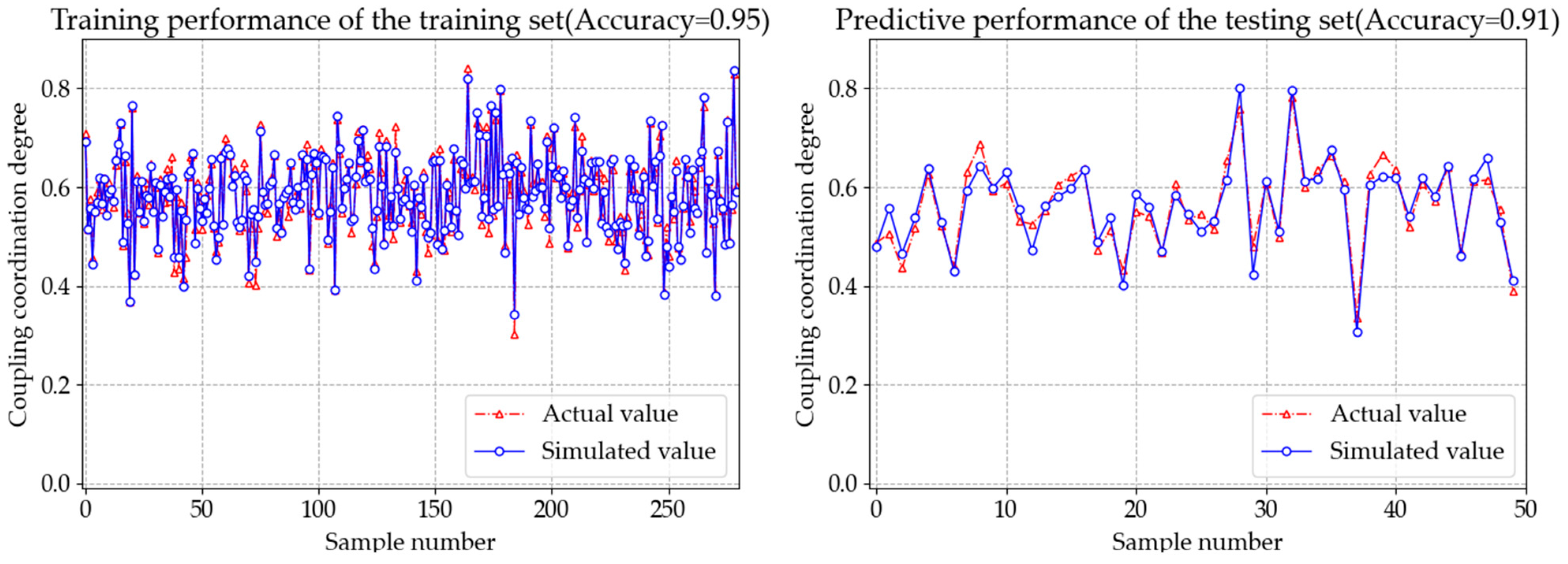
3.3.5. BP Neural Network

A Back Propagation (BP) neural network, comprising numerous processing units, functions as a nonlinear, adaptive information processing system. Mimicking the information processing and storage mechanisms of the human brain [45], BP neural networks are characterized by their backpropagation mechanism. This mechanism propagates error signals backward through the network, layer by layer. Local gradients, reflecting these error signals, are calculated for each hidden node, finally influencing the adjustment of weights and thresholds throughout the network. This iterative process minimizes the network’s loss error, enabling it to achieve a nonlinear mapping between input and output data [46].
This study leverages 31 tertiary indicators from Table 1 of the smart city spatial list as input features to model coupling coordination as the target variable. This results in a neural network architecture with 31 input nodes and a single output node. The number of nodes in the hidden layer is determined empirically utilizing the formula outlined in [47]:
K = m × n + α
where:
  • m represents the number of input layer nodes;
  • n represents the number of output layer nodes;
  • α represents a constant between 0 and 10;
  • K represents the number of hidden layer nodes.
Through an iterative experimental process, the mean squared error (MSE) is evaluated across varying numbers of hidden nodes. The MSE is minimized with 12 hidden nodes, leading to an optimal network structure of “31-12-1”. This trained neural network then explains the relationship between various factors and coupling coordination. Following the successful training and validation of the model, the influence weights of each factor are extracted.

3.4. Architecture of Methods

This paper employs a six-step method (Figure 3) to analyze smart city development. First, a tri-dimensional spatial evaluation model, termed the Smart City Potential Index (SPI), is established. Second, drawing upon the SPI model, a comprehensive index evaluation system is constructed across three key dimensions. Third, data are collected according to the index system, standardized utilizing the entropy weight method, and assigned corresponding weights. Fourth, a modified coupled coordination degree model is applied to the standardized data and indicator weights, generating a coupled coordination degree index. Fifth, based on the evaluation of the coupling coordination of the tri-dimensional space, an analysis of smart city development is undertaken, including regional difference analysis utilizing the Dagum Gini coefficient, dynamic evolution analysis through kernel density estimation, and predictive modeling utilizing a BP neural network. Finally, the study concludes by synthesizing key findings and offering policy recommendations.

4. Results

4.1. Assessment of Smart City Spatial Development

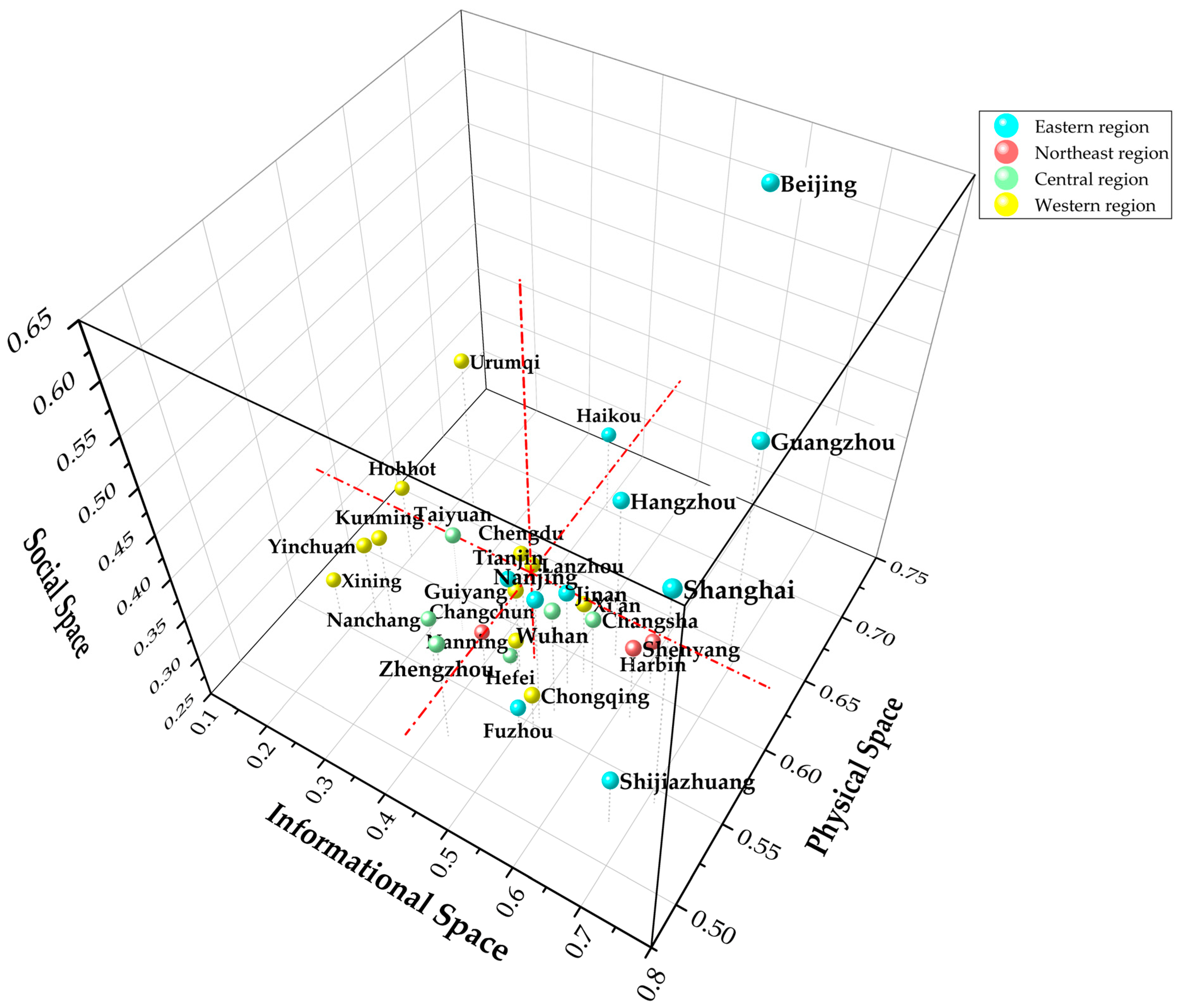
4.1.1. Comprehensive Assessment of Smart City Spatial Development

This study leverages entropy weight methodology to construct a comprehensive assessment index for smart city spatial development in China between 2011 and 2021 (Figure 4). From the overall growth perspective, we observe that the annual growth rate of smart cities from 2011 to 2014 remained relatively stable at a high level, followed by a period of more significant oscillations after 2015, finally exhibiting a downward trend. In terms of central tendency, the comprehensive development level of smart cities in China demonstrated consistent improvement from 2011 to 2021, evidencing a clear upward trend. This trend is reflected in the median values, with the exception of 2012, where the mean dips below the median. This pattern persists until 2017, after which the mean surpasses the median. This close alignment and minimal discrepancy between the mean and median values of the comprehensive assessment index suggest a relatively balanced development across provincial capitals and municipalities directly under the central government in China, indicating no significant differences. In addition, cities that initially lagged behind in development exhibit significant progress.
This study also analyzed the pairwise combinations of the tri-dimensional space to specifically calculate evaluation indices for each of the binary spatial subsystems. Overall, all four types of evaluation indices demonstrated a consistent upward trend from 2011 to 2021. Focusing on the scale of coupling coordination, the evaluation index for the “physical–social” space increased from 0.462 to 0.573, with the coupling coordination level rising from “nearing disarray decline” to “barely coordinated”. Similarly, the evaluation index for the “information–social” space climbed from 0.499 to 0.663, with its coupling coordination level progressing from “nearing disarray decline” to “basic coordination”. Likewise, the evaluation index for the “information–physical” space increased from 0.499 to 0.618, and its corresponding coupling coordination level also advanced from “nearing disarray decline” to “basic coordination”. The minimal differences observed between the evaluation indices of these three binary subsystems highlight a relatively balanced development pattern across the binary spatial relationships in China’s smart city development process. In addition, the evaluation index for the “information–physical–social” space demonstrated an increase from 0.505 to 0.646, with its coupling coordination level shifting from “barely coordinated” to “basic coordination”. Compared to the other three evaluation indices, this particular index exhibits some integration advantages, suggesting that the overall integration degree of the “information–physical–social” space in China’s smart city development is relatively superior. Specifically, after 2018, the development level of the “information–society” space started to surpass that of the overall SPI system, indicating that the coordinated development of this specific “information–society” binary subsystem is progressively offering strong support for the advancement of the broader SPI system.

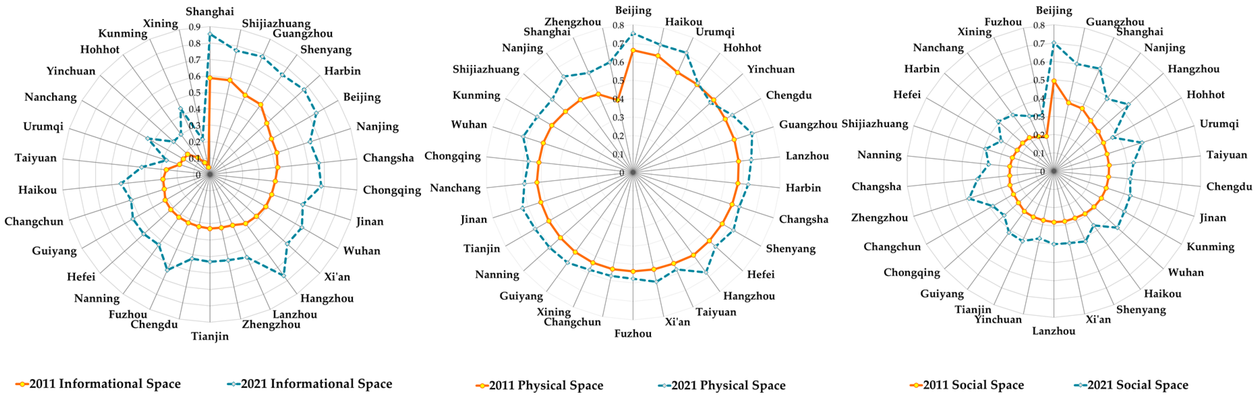
4.1.2. Subsystem Assessment of Smart City Spatial Development

We evaluate the level of smart city spatial development in 2011 and 2021 (Figure 5). In 2021, we observed an overall improvement in the level of smart city spatial development compared to 2011.
Specifically, the comprehensive index of the information space demonstrates a clear trend of “diffusion”. This indicates the significant effect of the rapid iteration and upgrade of information technology over the past decade, particularly in reshaping the information space. Simultaneously, a significant development gap is evident among smart cities, with polarization becoming more significant. In 2011, the top five cities were Shanghai (0.587), Shijiazhuang (0.586), Guangzhou (0.528), Guangzhou (0.525), and Harbin (0.465), whereas in 2021, the top five cities were Shanghai (0.854), Guangzhou (0.784), Harbin (0.771), Shijiazhuang (0.770), and Shenyang (0.763).
From the perspective of the comprehensive index of the physical space, a trend of slight fluctuation is evident overall, with relatively small development gaps. This suggests a mature level of development among smart cities. In 2011, the top five cities were Beijing (0.662), Haikou (0.646), Urumqi (0.593), Hohhot (0.589), and Yinchuan (0.588). While in 2021, the top five cities were Beijing (0.755), Urumqi (0.710), Haikou (0.707), Guangzhou (0.679), and Hangzhou (0.671).
In terms of the comprehensive index of the social space, a trend of significant fluctuation is evident overall, with some smart cities exhibiting more prominent development. In 2011, the top five cities were Beijing (0.493), Guangzhou (0.382), Shanghai (0.375), Nanjing (0.340), and Hangzhou (0.324). While in 2021, the top five cities were Beijing (0.702), Shanghai (0.613), Guangzhou (0.599), Hangzhou (0.545), and Urumqi (0.503).
In addition, conceptualizing the smart city spatial system with information space as the x-axis, physical space as the y-axis, and social space as the z-axis, all intersecting at their mean values, allows for a division of provincial capitals and municipalities directly under the central government into eight quadrants (Figure 6).
Analysis of the average level of smart city spatial development from 2011 to 2021 indicates different regional patterns. The first quadrant, representing the top tier, comprises leading cities such as Beijing, Hangzhou, and Guangzhou, forming a “triumvirate” of development. Located in eastern China, these cities are either established economic centers or capitals of economically strong provinces. They exhibit robust economic foundations, sophisticated social governance structures, and thriving digital economies.
The second, fourth, and fifth quadrants, belonging to the second tier, are characterized by a “two-strong-one-weak” development pattern, primarily concentrated in the eastern and northeastern regions. These cities function as key centers in northeastern, central, and western China, demonstrating significant innovative capacity and solid foundations in emerging information industries. While having rich histories, abundant resources, and favorable ecological conditions, they exhibit comparatively weaker economic development and less diversified social governance structures.
Cities in the third, sixth, and eighth quadrants comprise the third tier, displaying a “two-weak-one-strong” pattern of development. These cities, primarily located in central and western regions, are often proximate to more developed areas and experience spillover benefits from burgeoning industries. Despite solid foundations in emerging information industries, enhanced by supportive technological policies, their economic development trails behind. They also face challenges in resource allocation and social governance, resulting in less significant advantages in physical and social spatial development.
The seventh quadrant represents the fourth tier, including cities such as Tianjin, Changchun, Nanchang, Guiyang, Kunming, Xining, and Yinchuan, all characterized by a “three-weak” development pattern. These cities, frequently representing capitals of provinces with relatively underdeveloped economies, lack unique geographical advantages. They experience lower per capita resource ownership rates, have relatively weak economic foundations, and face challenges in establishing effective social governance systems and upgrading industrial structures.

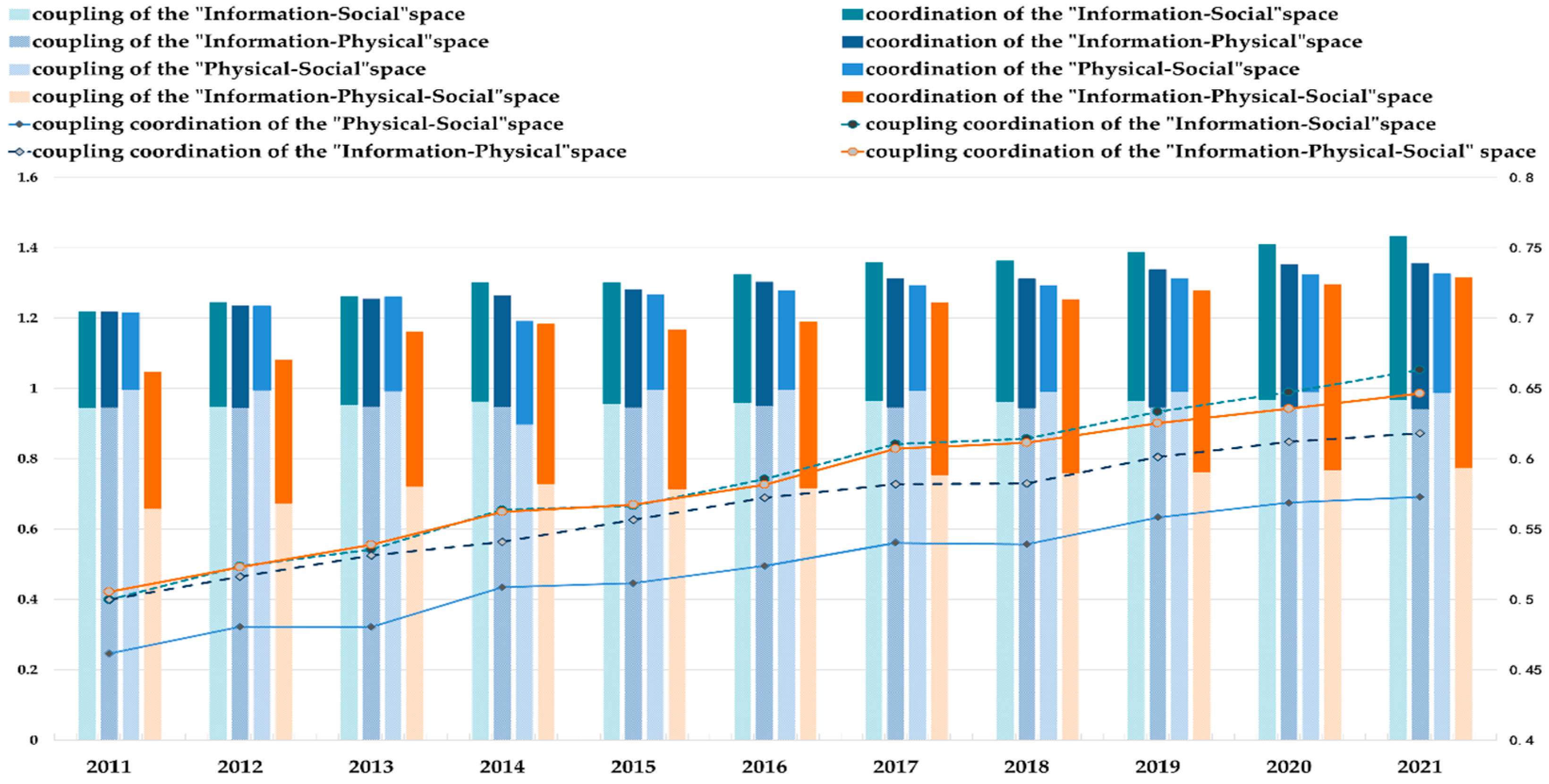
4.2. Descriptive Analysis of Smart City Spatial Coupling Coordination

4.2.1. Overall Characteristics

The revised coupling coordination model indicates a steady upward trend in the spatial coupling coordination of 30 Chinese smart cities between 2011 and 2021 (Table 5). The national ranking of spatial coupling coordination development is at a moderate level, indicating a relatively balanced development of spatial coupling coordination among Chinese smart cities. Specifically, 13 cities, including Zhengzhou, Changsha, Guiyang, and Lanzhou, significantly improved their rankings by 8, 7, 7, and 5 places, respectively, since 2011, highlighting their rapid progress in spatial coupling coordination, whereas 13 cities experienced a decline in their rankings, with Shijiazhuang, Shenyang, Chongqing, and Chengdu falling by 14, 9, 7, and 7 spots, respectively. This downward movement suggests a potential slowdown in spatial coupling coordination development in these cities compared to their counterparts.
The evolution of spatial coupling coordination in smart cities from 2011 to 2021 indicates a clear upward trend, with a majority transitioning to a higher coordination level. Specifically, in 2011, the spatial coupling coordination of smart cities mainly exhibited four stages: “slight imbalance and decline”, “imminent imbalance and decline”, “barely coordinated integration”, and “basic coordinated development”. Cities suffering from fragile coordination and decline, alongside those barely integrated, were prevalent across all regions of China; conversely, cities experiencing slight imbalance and decline were less common and primarily situated in western regions, while those demonstrating basic coordinated development were similarly less prevalent and largely concentrated in the east.
As of 2021, the spatial coordination of smart cities indicated five tiers: fragile coordination, barely coordinated, basic coordination, intermediate coordination, and well-coordinated. Cities in the stages of basic coordination and intermediate coordination were relatively more common. The former were primarily located in the central, western, and northeastern regions, while the latter were primarily concentrated in the east. Specifically, Xining stood out as the sole city on the verge of imbalance and decline, whereas Hohhot, Yinchuan, and Urumqi, all situated in western China, exhibited tenuous coordination. Beijing became the only city to achieve well-coordinated status, highlighting its significant lead in spatial coordination development.

4.2.2. Regional Disparities

Table 6 illustrates the regional differences and contribution rates of spatial coupling coordination in smart cities. The overall Dagum Gini coefficient, which measures this coordination, trends downwards, falling from 0.079 in 2011 to 0.059 in 2021. This decline signifies a gradual narrowing of the development gap in spatial coupling coordination among Chinese smart cities. Similarly, the in-group, between-group, and hyper-variation density Gini coefficients all decreased over the period studied. This suggests that development disparities in spatial coupling coordination are reducing both in and between regions. Analyzing the contribution rates of each component of the Dagum Gini coefficient indicates that the between-group Gini coefficient consistently contributes the most, remaining above 50% throughout the study period; conversely, the in-group Gini coefficient and hyper-variation density contribute comparatively less. This highlights that the uneven development of spatial coupling coordination in Chinese smart cities is primarily driven by differences between regions, while disparities arising from in-region variations and overlaps between regions contribute relatively less.
Furthermore, the results of the Dagum Gini coefficient decomposition (Table 7) indicate that the differences in spatial coupling and coordination of smart cities in each of the four major regions have all reduced. When considering the average in-group Gini coefficient across the four major regions, the western region displays the highest Gini coefficient. This suggests that the disparity in spatial coupling and coordination among smart cities in the western region is the most significant. The eastern region follows with the second highest Gini coefficient. The northeastern region’s Gini coefficient is slightly increased compared to that of the central region. Meanwhile, the central region exhibits the smallest Gini coefficient, indicating the least significant difference in spatial coupling and coordination among smart cities in this region. When analyzing the average between-group Gini coefficient across the four major regions, both the eastern and western regions exhibit a mean between-group Gini coefficient of 0.097. This value is significantly higher than those observed in other interregional comparisons. This difference implies a comparatively larger disparity in spatial coupling and coordination of smart cities between the eastern and western regions, whereas the mean between-group Gini coefficient for the eastern region and the northeastern region is 0.052, which is lower than that observed in other interregional comparisons. This suggests a relatively smaller disparity in spatial coupling and coordination of smart cities between the eastern and northeastern regions.

4.2.3. Dynamic Evolution

The kernel density curve presented in Figure 7A indicates a clear trend in the overall spatial coupling and coordination of smart cities across China. In the Figure, darker colors mean lower density, and lighter ones mean higher density. The significant rightward shift of the curve indicates consistent growth in spatial coupling and coordination throughout the analyzed period. Moreover, the bimodal distribution, with its primary peak steadily rising and secondary peak becoming less variable, points to increasing polarization in how smart cities across China are spatially coupled and coordinated. Finally, the narrowing opening width and thickening left tail of the curve demonstrate a gradual reduction in the differences in spatial coupling and coordination between Chinese cities over time. In conclusion, while China’s smart cities have experienced continual improvement in spatial coupling and coordination, nationwide polarization persists, even as disparities between cities reduce.
As illustrated in Figure 7B, the eastern region exhibits a growing number of peaks, with peak heights reaching their apex in 2017 before entering a period of gradual decline. The narrowing of the curve’s opening width observed from 2011 to 2015, followed by annual expansion post-2015, coupled with a unique right tail, suggests a reducing regional difference in the spatial coupling coordination of smart cities in the East, signifying a transition towards a more multipolar configuration.
Figure 7C indicates a progressive rightward shift in the kernel density curve for the northeast region, accompanied by annual growth in peak heights. The observed annual narrowing of the opening width, transition from bimodal to unimodal peaks, and shortening of the left tail collectively indicate an overall increase in the spatial coupling coordination of smart cities in the northeast, with development patterns becoming increasingly concentrated.
Figure 7D evidences that the central region’s kernel density curve displays relative stability from 2011 to 2017 before exhibiting annual steepening thereafter. Peak heights demonstrate an annual decrease post-2013, followed by a rebound after 2017, concurrent with a narrowing opening width and a prominent left tail. These observations suggest a significant trend towards multipolar development in the spatial coupling coordination of smart cities in the central region, accompanied by a gradual increase in regional differences.
Figure 7E demonstrates a peak for the western region in 2013, succeeded by a gradual annual decline. The expanding opening width of the kernel density curve post-2013 and the thickening left tail point to a growing absolute difference in the spatial coupling coordination of smart cities in the western region, with minimal variation in the observed polarization phenomenon.

4.3. Inferential Analysis of Smart City Spatial Coupling Coordination

This study leveraged a BP neural network to analyze the contribution differences of 31 indicators in a smart city spatial system towards achieving coupling coordination, finally identifying key influencing factors. The BP neural network algorithm was implemented in Python utilizing statistical libraries. Thirty-one indicators, detailed in Table 1, Table 2 and Table 3, representing various facets of the smart city spatial system, were designated as input nodes, while coupling coordination represented the output node. Following normalization, a dataset comprising 330 samples was constructed, including data from 30 smart cities between 2011 and 2021. Of this dataset, 280 samples were allocated for training the neural network and the remaining 50 were reserved for testing. A series of simulations yielded satisfactory results, demonstrating a strong correlation between simulated and actual values. Both the training and testing sets exhibited excellent fitting, achieving accuracy rates of 95% and 91%, respectively (Figure 8). This high level of accuracy highlights the model’s feasibility. Then, weights assigned to connections between the input and hidden layers, as well as between the hidden and output layers, were extracted. These weights were then employed to calculate the contribution rates of each indicator to the overall coupling coordination in the smart city spatial system.
Figure 9 illustrates the contribution rates of information space (blue bars), physical space (green bars), and social space (orange bars) to coupling coordination, at 39.09%, 29.07%, and 31.84%, respectively. While the data initially suggest that physical space plays the most significant role in smart city coupling coordination, this study takes into account the significant differences in third-level indicators across different spatial systems. To offer a more accurate assessment, we utilize the average indicator contribution rate for each unidimensional subsystem. These rates, for information space, physical space, and social space, are 5.31%, 2.08%, and 3.55%, respectively. This optimized analysis indicates that information space actually holds the most significant role in coupling coordination, followed by social space, with physical space having the least effect. This finding aligns with the increasingly prominent role of information space in empowering smart cities, particularly in rapid advancements in digital technology. In addition, the increasing emphasis on diversified social governance further highlights the importance of effective coordination and collaboration among governing entities. This collaborative approach facilitates the integration and realization of diverse resource elements in smart cities; on the other hand, physical space, traditionally a focal point in smart city development models, has reached a relative level of maturity, hence its marginal benefits are relatively low.

5. Discussion

5.1. Pathways of Development

The concept of “smart cities” has captivated China since the launch of its pilot programs in 2012. Over a decade later, this vision of urban modernity remains a vibrant and highly contested topic in academia, often described as a “new, hopeful, but contentious research field” [48] that is actively reshaping how we approach urban governance. However, a significant gap persists between the theoretical ideals of highly perceptive and intelligent urban systems and the reality of what has been achieved on the ground. Building upon existing research, this paper proposes three policy recommendations to guide the future development of smart cities in China.
Firstly, consideration in smart city development should be accorded to the optimization of spatial development patterns through coordinated planning. Recognizing the differences in resources across China’s diverse regions, it is crucial to acknowledge the path-dependent nature of development. To fully realize the potential of smart cities, the coupling coordination of ternary space is essential. This necessitates an approach to planning and design that cultivates synergy and complementarity among these elements. For instance, in the social space, empowering citizens with enhanced digital literacy and skills should be prioritized alongside advancements in government and enterprise.
Secondly, cultivating interregional synergy and innovation exchange is crucial for driving cross-regional collaboration and resource optimization. As previously noted, smart cities exhibit diverse strengths. By promptly identifying and disseminating best practices, practical insights, and shared challenges across regions, levels, and scales, we can unlock a “leapfrog effect” through model replication and knowledge sharing. Establishing inter-regional digital economy platforms, for instance, can facilitate mutual benefits and collectively elevate smart city development nationwide. Simultaneously, cultivating a spirit of cooperative competition among cities will be essential for stimulating innovation and progress.
Thirdly, a multidimensional approach to developing smart city spaces is crucial. Local governments should prioritize policies that significantly contribute to this development. This includes enhancing investments in information technology infrastructure, cultivating the growth of high-tech industries, actively attracting and nurturing skilled professionals, and offering robust intellectual capital for smart cities. Simultaneously, a people-centric planning approach is paramount for smart city development. Integrating the principles of social responsibility throughout the development process is essential, promoting the coordinated development of both material and cultural progress. In addition, addressing the growing concerns of an aging population is vital. This involves strengthening pension security policies for the elderly, broadening the reach of social welfare programs, and finally enhancing overall public well-being.

5.2. Limitations

This paper has certain limitations. While we primarily appraise interactions between the overall system, two-dimensional subsystems, and one-dimensional subsystems, the potential for interaction effects among indicators in one-dimensional subsystems necessitates further research. In addition, the COVID-19 pandemic and the lockdowns in China from 2022 to 2023 resulted in the suspension or simplification of the China City Statistical Yearbook. While acknowledging that smart city development may not have been significantly affected in the short-term due to the economic downturn, we emphasize the need for more comprehensive data to further advance this research.

6. Conclusions

This study evaluates the spatial development levels of smart cities, analyzing the coordination relationships between diverse spaces through the perspective of the ternary space. In addition, it offers a holistic assessment of the significant strides made in China’s smart city development over the past decade. The key findings of this study are outlined below.

6.1. Overall Positive Development Trend but Still in Early Stages

The development trend of smart cities in China is generally positive. The study period witnessed progress in the overall development of various smart city dimensions. When analyzing the two-dimensional subsystems, the coupling and coordination degree of smart city spaces is as follows: “Information–Society” space > “Information–Physical–Society” space > “Information–Physical” space > “Physical–Society” space. Significant differences exist among the comprehensive indices of the information, physical, and social spaces, indicating “diffusion”, “floating”, and “fluctuating” development trends, respectively. In addition, significant differences characterize the development of individual subsystems in each smart city dimension. This is evidently a clear tiered system, primarily characterized by a “two-strong-one-weak” or “two-weak-one-strong” pattern in the second and third tiers. Finally, the coupling and coordination of smart city dimensions have evolved from a four-stage to a five-stage model. Currently, most smart cities in the initial coordination stage exhibit a gradual but positive improvement towards greater coupling and coordination.

6.2. Important Influence of Regional Environment and Development Characteristics

The characteristics of regional environments and development significantly affect the integration and coordination of smart city spaces. In terms of regional differentiation, the differences in the level of integration and coordination among smart city spaces across the other three major regions have lessened. The inter-regional Gini coefficient for the integration and coordination of smart city spaces follows this order: western region > eastern region > northeastern region > central region. The most significant differences in integration and coordination are found between the eastern and western regions, while the least significant are between the eastern and northeastern regions. Specifically, throughout the study period, the integration and coordination of smart city spaces in China have steadily improved. This progress is marked by a significant decrease in absolute differences between cities nationwide, while significant polarization persists.

6.3. Significant Differences of Contribution in Evaluation Indicators

Tertiary indicators have a significantly different effect on the evaluation of coupling and coordination in smart city spatial development. Among the three one-dimensional subsystems, average indicator contribution rates of the three one-dimensional subsystems to the coupling and coordination degree are 5.31%, 2.08%, and 3.55%, respectively. Specifically, the information space subsystem plays the most influential role. The analysis indicates that year-end mobile phone penetration, per capita park green space, and unemployment insurance coverage are the contributing indicators to the development of smart city spaces in China.

Author Contributions

C.W., C.Z. and M.D. contributed to the study conception and design. Material preparation and data processing were performed by C.Z. and M.D. The first draft of the manuscript was written by C.W. and C.Z. revised and improved manuscript. All authors have read and agreed to the published version of the manuscript.

Funding

This research was funded by The Ministry of Education of Humanities and Social Science Project (Grant number: 23YJC630173); & Social Science Fund of Jiangsu Province, China (Grant number: 23GLC006); & Basic scientific research project in universities (Grant number: 2022SK09).

Data Availability Statement

The original contributions presented in the study are included in the article; further inquiries can be directed to the corresponding author.

Conflicts of Interest

The authors declare no conflicts of interest.

References

  1. Shelton, T.; Zook, M.; Wiig, A. The ‘actually existing smart city’. Camb. J. Reg. Econ. Soc. 2015, 8, 13–25. [Google Scholar] [CrossRef]
  2. Khatibi, H.; Wilkinson, S.; Sweya, L.N.; Baghersad, M.; Dianat, H. Navigating Climate Change Challenges through Smart Resilient Cities: A Comprehensive Assessment Framework. Land 2024, 13, 266. [Google Scholar] [CrossRef]
  3. Qiu, Z. Establishment and Countermeasures of Smart City Security Risk Assessment Model. Adv. Comput. Commun. 2023, 3, 70–73. [Google Scholar] [CrossRef]
  4. Laufs, J.; Borrion, H.; Bradford, B. Security and the smart city: A systematic review. Sustain. Cities Soc. 2020, 55, 102023. [Google Scholar] [CrossRef]
  5. Niu, S.; Zhang, K.; Zhang, J.; Feng, Y. How Does Industrial Upgrading Affect Urban Ecological Efficiency? New Evidence from China. Emerg. Mark. Financ. Trade 2024, 60, 899–920. [Google Scholar] [CrossRef]
  6. Zheng, L. Content, Path and Direction of Urban Digital Transformation. Explor. Free Views 2021, 4, 147–152+180. [Google Scholar]
  7. Sun, X.; Liu, N. The Governance of Urban Community Public Space from the Perspective of Space Theory. Shanghai Urban Manag. 2022, 31, 61–67. [Google Scholar]
  8. Paroutis, S.; Bennett, M.; Heracleous, L. A strategic view on smart city technology: The case of IBM Smarter Cities during a recession. Technol. Forecast. Soc. Change 2014, 89, 262–272. [Google Scholar] [CrossRef]
  9. Ojo, A.; Curry, E.; Janowski, T. Designing next generation smart city initiatives-harnessing findings and lessons from a study of ten smart city programs. In Proceedings of the ECIS 2014 Proceedings-22nd European Conference on Information Systems, Tel Aviv, Israel, 9–11 June 2014. [Google Scholar]
  10. Shamsuzzoha, A.; Nieminen, J.; Piya, S.; Rutledge, K. Smart city for sustainable environment: A comparison of participatory strategies from Helsinki, Singapore and London. Cities 2021, 114, 103194. [Google Scholar] [CrossRef]
  11. Al Sharif, R.; Pokharel, S. Smart city dimensions and associated risks: Review of literature. Sustain. Cities Soc. 2022, 77, 103542. [Google Scholar] [CrossRef]
  12. Patrão, C.; Moura, P.; Almeida, A.T. Review of smart city assessment tools. Smart Cities 2020, 3, 1117–1132. [Google Scholar] [CrossRef]
  13. Sharifi, A. A typology of smart city assessment tools and indicator sets. Sustain. Cities Soc. 2020, 53, 101936. [Google Scholar] [CrossRef]
  14. Shi, G.; Liang, B.; Ye, T.; Zhou, K.; Sun, Z. Exploring the Coordinated Development of Smart-City Clusters in China: A Case Study of Jiangsu Province. Land 2024, 13, 308. [Google Scholar] [CrossRef]
  15. Deeb, Y.I.; Alqahtani, F.K.; Bin Mahmoud, A.A. Developing a Comprehensive Smart City Rating System: Case of Riyadh, Saudi Arabia. J. Urban Plan. Dev. 2024, 150, 04024012. [Google Scholar] [CrossRef]
  16. Joyce, A.; Javidroozi, V. Smart city development: Data sharing vs. data protection legislations. Cities 2024, 148, 104859. [Google Scholar] [CrossRef]
  17. Sorri, K.; Yrjönkoski, K.; Seppänen, M. Smart cities, smarter values: Unpacking the ecosystem of urban innovation. Technol. Soc. 2024, 77, 102499. [Google Scholar] [CrossRef]
  18. José, R.; Rodrigues, H. A Review on Key Innovation Challenges for Smart City Initiatives. Smart Cities 2024, 7, 141–162. [Google Scholar] [CrossRef]
  19. Kavitha, M.M.; Golden, E.J. Smarter and resilient smart contracts applications for smart cities environment using blockchain technology. Automatika 2024, 65, 572–583. [Google Scholar]
  20. Skyworks Showcases Its Momentum for Smart Cities, Automotive and More at the Consumer Electronics Show Booth No. 9627. Businesswire 9 January 2024.
  21. Deveci, M.; Pekaslan, D.; Canıtez, F. The assessment of smart city projects using zSlice type-2 fuzzy sets based Interval Agreement Method. Sustain. Cities Soc. 2020, 53, 101889. [Google Scholar] [CrossRef]
  22. Xiang, Y.; Xie, X. Digital twin city governance: Changes, dilemmas and countermeasures. E-Government 2021, 10, 69–80. [Google Scholar]
  23. Mei, J. Technology adapts to the city: Subject oppression and ethical dilemmas in digital transformation. Theory Reform 2021, 3, 90–101. [Google Scholar]
  24. Mao, Z.; Huang, Y.; Xu, X. Information Security Risk Analysis and Countermeasures of Smart City from the Perspective of Information Ecology. Chin. Public Adm. 2019, 9, 123–129. [Google Scholar]
  25. Zou, W.; Zhang, L. From Compartmentalization to Integration: The Compartmentalization Dilemma of Smart Cities and Strategies for Reconfiguring the Socio-Technical Imagination. J. Tianjin Adm. Inst. 2023, 25, 53–64. [Google Scholar]
  26. Bhattacharya, T.R.; Bhattacharya, A.; Mclellan, B.; Tezuka, T. Sustainable smart city development framework for develo** countries. Urban Res. Pract. 2020, 13, 180–212. [Google Scholar] [CrossRef]
  27. Richey, B.F. Risk Management Framework 2.0; Iowa State University: Ames, IA, USA, 2016. [Google Scholar]
  28. Hiller, J.S.; Russell, R.S. Privacy in crises: The NIST privacy framework. J. Contingencies Crisis Manag. 2017, 25, 31–38. [Google Scholar] [CrossRef]
  29. Abdullah, H.A.; Nizam, H.T.; Kutub, T. The Evolution of Information Security Strategies: A Comprehensive Investigation of INFOSEC Risk Assessment in the Contemporary Information Era. Comput. Inf. Sci. 2023, 16, 1. [Google Scholar]
  30. Meijer, A.; Bolívar, M.P.R. Governing the smart city: A review of the literature on smart urban governance. Int. Rev. Adm. Sci. 2016, 82, 392–408. [Google Scholar] [CrossRef]
  31. Neirotti, P.; De Marco, A.; Cagliano, A.C.; Mangano, G.; Scorrano, F. Current trends in Smart City initiatives: Some stylised facts. Cities 2014, 38, 25–36. [Google Scholar] [CrossRef]
  32. Winkowska, J.; Szpilko, D.; Pejić, S. Smart city concept in the light of the literature review. Eng. Manag. Prod. Serv. 2019, 11, 70–86. [Google Scholar] [CrossRef]
  33. Nam, T.; Pardo, T.A. Conceptualizing smart city with dimensions of technology, people, and institutions. In Proceedings of the 12th Annual International Digital Government Research Conference: Digital Government Innovation in Challenging Times, College Park, MD, USA, 12–15 June 2011; pp. 282–291. [Google Scholar]
  34. Yang, L.; Gan, Q.; Ma, D. Public environmental concern and corporate environmental investment—From the perspective of the moderating effect of green image. Financ. Account. Mon. 2020, 8, 33–40. [Google Scholar]
  35. Shan, Z.; Xu, Q.; Ma, C.; Tang, S.; Wang, W. Digital economy development evaluation system and prospects based on ternary space theory. Macroecon. Manag. 2020, 2, 42–49. [Google Scholar]
  36. Hui, P. Construction of Information Security Risk Assessment Model in Smart City. In Proceedings of the 2020 IEEE Conference on Telecommuni-cations, Optics and Computer Science (TOCS), Shenyang, China, 11–13 December 2020; pp. 393–396. [Google Scholar] [CrossRef]
  37. Liu, X.; Li, X.; He, W.; Shen, C. The Coupling Coordination Degree of Human-Land and the Spatial Allocation of “Production-Living-Ecological”: A Case Study of Jiangsu Province. Mod. Urban Res. 2022, 10, 66–72. [Google Scholar]
  38. Zhang, J.; Zhai, J. Measurement of coupling coordination degree in China’s “Three Living Spaces”. Urban Probl. 2019, 11, 38–44. [Google Scholar]
  39. Xie, G.; Jiang, S.; Zhao, C. Analysis of the coupling coordination level of regional economy, urbanization and social governance. Stat. Decis. 2020, 36, 127–130. [Google Scholar]
  40. Zou, X.; Xie, M.; Xiao, Z.; Wu, T.; Yin, Y. Evaluation of rural development and diagnosis of obstacle factors based on entropy weight topsis method. Chin. J. Agric. Resour. Reg. Plan. 2021, 42, 197–206. [Google Scholar]
  41. Li, R.; Huang, X.; Liu, Y. Spatio-temporal differentiation and influencing factors of China’s urbanization from 2010 to 2020. Acta Geogr. Sin. 2023, 78, 777–791. [Google Scholar]
  42. Wang, S.J.; Kong, W.; Ren, L.; Zhi, D.D. Research on misuses and modification of coupling coordination degree model in China. J. Nat. Resour. 2021, 36, 793–810. [Google Scholar] [CrossRef]
  43. Wu, C.; Zhou, X.; Huang, C. Study on the coupling and coordination relationship between the optimization of industrial structure and the construction of ecological civilization of ecological civilization in the Yangtze River Economic Belt. J. Cent. China Norm. Univ. (Nat. Sci.) 2020, 54, 555–566. [Google Scholar]
  44. Ge, S.S.; Zeng, G.; Yang, Y.; Hu, H. The coupling relationship and spatial characteristics analysis between ecological civilization construction and urbanization in the Yellow River Economic Belt. J. Nat. Resour. 2021, 36, 87–102. [Google Scholar] [CrossRef]
  45. Zhang, P.; Yang, X.; Chen, Z. Neural network gain scheduling design for large envelope curve flight control law. J. Beijing Univ. Aeronaut. Astronaut. 2005, 31, 604–608. [Google Scholar]
  46. Yang, X.; Gong, G.; Tian, Y.; Yu, X. Generalized Optimal Game Theory in virtual decision-makings. In Proceedings of the 2008 Chinese Control and Decision Conference, Yantai, China, 2–4 July 2008; pp. 2–4. [Google Scholar]
  47. Shen, H.; Wang, Z.; Gao, C.; Qin, J.; Yao, F.; Xu, W. Determining the number of BP neural network hidden layer units. J. Tianjin Univ. Technol. 2008, 5, 13–15. [Google Scholar]
  48. Meng, F.; Wu, X. Revisiting “Smart City”: Three Basic Research Questions—Based on a Systematic Review of English Literature. Public Adm. Policy Rev. 2022, 11, 148–168. [Google Scholar]
Figure 1. Study area of 30 national or provincial capitals.
Land 13 00872 g001
Figure 2. The SPI model of a smart city.
Land 13 00872 g002
Figure 3. Architecture of methods.
Land 13 00872 g003
Figure 4. Comprehensive assessment of smart city spatial development.
Land 13 00872 g004
Figure 5. The smart city spatial development assessment index of subsystems of in 2011 and 2021.
Land 13 00872 g005
Figure 6. The average level of smart city spatial development from 2011 to 2021.
Land 13 00872 g006
Figure 7. The kernel density of spatial coupling coordination of smart cities from 2011 to 2021.
Land 13 00872 g007
Figure 8. Training and Predictive performance of the dataset and its accuracies.
Land 13 00872 g008
Figure 9. Contribution rates of factors in the coupling coordination of smart city spatial systems analyzed based on a BP neural network.
Land 13 00872 g009
Table 1. System of SPI-based indices for smart city evaluation of informational space.
Target LevelStandardized LayerIndex LayerNO.Index
Properties
WeightSource
Informational Space Subsystem
(IS)
Data
(IS1)
Peking University Digital Inclusive Finance IndexIS1-1+0.167 [35]
Algorithm
(IS2)
R&D personnel ratio (%)IS2-1+0.167 [35,36]
The proportion of employees in the information transmission, computer services, and software industries (%)IS2-2+0.163[35]
Computational
Power
(IS3)
Internet penetration (%)IS3-1+0.170[35]
Per capita total telecommunications services (yuan)IS3-2+0.169[35]
The proportion of mobile phone users at the end of the year (%)IS3-3+0.164[35]
Table 2. System of SPI-based indices for smart city evaluation of physical space.
Target LevelStandardized LayerIndex LayerNO.Index
Properties
WeightSource
Physical
Space
Subsystem
(PS)
Production
(PS1)
The proportion of production land (%)PS1-1+0.063[38]
Advanced industrial structure (%) PS1-2+0.071[38]
Upgrading of industrial structure (%)PS1-3+0.072[38]
Living
(PS2)
Population density (%)PS2-10.073[37,39]
Public library holdings per capita (volume)PS2-2+0.067[35,38,39]
Per capita park green space area (square meters)PS2-3+0.068[37,38,39]
Per capita medical institutionsPS2-4+0.072[38,39]
Per capita educational resources (persons)PS2-5+0.074[38,39]
Ecology
(PS3)
GDP energy intensity (yuan/billion kilowatt hours)PS3-10.074Original
Industrial wastewater discharge intensity (%)PS3-20.074[37,38]
Industrial sulfur dioxide emission intensity (%)PS3-30.074[37,38]
Harmless treatment rate of household waste (%)PS3-4+0.074[37,38]
Industrial smoke (powder) dust emission intensity (%)PS3-50.074[38]
Comprehensive utilization rate of general industrial solid waste (%)PS3-6+0.073[38]
Table 3. System of SPI-based indices for smart city evaluation of social space.
Target LevelStandardized LayerIndex LayerNO.Index
Properties
WeightSource
Social
Space Subsystem
(SS)
Government
(SS1)
Unemployment rate (%)SS1-10.095[37,39]
Government financial support (%)SS1-2+0.091[37,39]
The proportion of insured individuals in unemployment insurance (%)SS1-3+0.087[39]
The proportion of urban employees participating in basic pension insurance (%)SS1-4+0.089[39]
The proportion of urban employees participating in basic medical insurance (%)SS1-5+0.089[39]
Society
(SS2)
Network search indexSS2-1+0.092[34]
The proportion of employees in public management and social organizations (%)SS2-2+0.091Original
The proportion of employees in the health, social insurance, and social welfare industries (%)SS2-3+0.093Original
General Public
(SS3)
Average salary of employees (yuan)SS3-1+0.090Original
Per capita education level (year)SS3-2+0.092[37]
Per capita year-end RMB deposit balance of financial institutions (yuan)SS3-3+0.090Original
Table 4. Criteria for classifying SPI-based coupling coordination level indices.
Coordination PhaseDegree of Coupling CoordinationCoordination Index
Disordered typeExtremely disordered(0, 0.1]
Severely disordered(0.1, 0.2]
Mildly disordered(0.2, 0.3]
Endangered coordination(0.3, 0.4]
Transition typeFragile coordination(0.4, 0.5]
Barely coordinated(0.5, 0.6]
Basic coordination(0.6, 0.7]
Coordinated developmentIntermediate coordination(0.7, 0.8]
Well-coordinated(0.8, 0.9]
High-quality coordination(0.9, 1]
Table 5. Spatial coupling coordination of smart cities from 2011 to 2021.
City (Ranked)20112012201320142015201620172018201920202021
Beijing0.638 0.667 0.693 0.708 0.718 0.737 0.759 0.782 0.796 0.829 0.841
Guangzhou0.639 0.677 0.662 0.722 0.721 0.727 0.736 0.730 0.759 0.759 0.762
Shanghai0.610 0.626 0.667 0.661 0.679 0.700 0.713 0.723 0.728 0.730 0.723
Hangzhou0.550 0.603 0.604 0.664 0.644 0.652 0.693 0.703 0.727 0.728 0.737
Nanjing0.593 0.597 0.589 0.626 0.637 0.647 0.653 0.665 0.687 0.711 0.723
Wuhan0.547 0.564 0.590 0.631 0.622 0.629 0.648 0.662 0.665 0.704 0.704
Jinan0.550 0.549 0.589 0.611 0.637 0.638 0.654 0.659 0.651 0.667 0.681
Shenyang0.584 0.590 0.586 0.611 0.611 0.619 0.635 0.646 0.644 0.664 0.663
Changsha0.520 0.556 0.575 0.589 0.611 0.635 0.661 0.665 0.663 0.665 0.668
Xi’an0.533 0.552 0.571 0.606 0.617 0.608 0.634 0.624 0.650 0.648 0.667
Harbin0.529 0.540 0.553 0.601 0.608 0.610 0.620 0.611 0.637 0.649 0.650
Zhengzhou0.514 0.517 0.549 0.554 0.590 0.604 0.639 0.629 0.655 0.665 0.688
Lanzhou0.511 0.516 0.556 0.570 0.610 0.607 0.622 0.623 0.646 0.632 0.645
Tianjin0.510 0.548 0.543 0.588 0.579 0.588 0.605 0.615 0.634 0.639 0.654
Guiyang0.501 0.540 0.540 0.564 0.582 0.581 0.622 0.630 0.637 0.640 0.656
Average0.505 0.523 0.539 0.562 0.568 0.582 0.607 0.612 0.625 0.636 0.646
Chongqing0.530 0.503 0.516 0.571 0.552 0.603 0.620 0.624 0.626 0.627 0.625
Shijiazhuang0.542 0.524 0.542 0.554 0.556 0.570 0.613 0.604 0.610 0.634 0.631
Chengdu0.515 0.519 0.511 0.561 0.545 0.559 0.591 0.600 0.607 0.626 0.648
Nanning0.487 0.520 0.540 0.546 0.555 0.569 0.585 0.589 0.604 0.619 0.619
Fuzhou0.459 0.506 0.532 0.547 0.556 0.558 0.615 0.593 0.592 0.594 0.606
Taiyuan0.492 0.492 0.525 0.525 0.543 0.548 0.566 0.569 0.616 0.625 0.622
Haikou0.487 0.490 0.518 0.526 0.544 0.561 0.582 0.593 0.608 0.594 0.614
Changchun0.481 0.486 0.490 0.522 0.509 0.521 0.548 0.573 0.593 0.609 0.631
Hefei0.477 0.497 0.481 0.526 0.530 0.505 0.541 0.553 0.577 0.594 0.611
Nanchang0.415 0.470 0.482 0.510 0.487 0.518 0.557 0.561 0.582 0.588 0.601
Urumqi0.446 0.434 0.472 0.468 0.471 0.491 0.526 0.519 0.541 0.547 0.552
Kunming0.369 0.388 0.440 0.468 0.456 0.461 0.511 0.530 0.545 0.555 0.632
Yinchuan0.429 0.455 0.463 0.422 0.431 0.493 0.507 0.507 0.519 0.520 0.536
Hohhot0.407 0.432 0.402 0.426 0.436 0.477 0.468 0.486 0.491 0.514 0.531
Xining0.301 0.335 0.385 0.392 0.390 0.432 0.491 0.479 0.471 0.498 0.472
Table 6. Regional disparities of spatial coupling coordination of smart cities.
YearThe Overall
Gini Coefficient
The Intra-Group
Gini Coefficient
The Inter-Group
Gini Coefficient
The Contribution of
Hyperdensity
20110.079 0.019 0.048 0.012
20120.076 0.018 0.048 0.010
20130.072 0.017 0.046 0.009
20140.077 0.018 0.048 0.011
20150.079 0.018 0.042 0.018
20160.071 0.016 0.036 0.018
20170.064 0.014 0.034 0.015
20180.064 0.015 0.032 0.017
20190.063 0.015 0.039 0.008
20200.062 0.015 0.039 0.008
20210.059 0.015 0.035 0.010
Table 7. Decomposition of Dagum Gini coefficient.
Decomposition 20112012201320142015201620172018201920202021
The intra-group
Gini coefficient
EC0.060 0.061 0.056 0.059 0.057 0.057 0.049 0.053 0.056 0.059 0.056
NE0.033 0.035 0.032 0.035 0.030 0.030 0.029 0.028 0.020 0.022 0.020
CI0.037 0.012 0.019 0.007 0.024 0.018 0.010 0.006 0.014 0.014 0.008
WE0.085 0.077 0.069 0.077 0.083 0.065 0.058 0.057 0.060 0.052 0.056
The inter-group
Gini coefficient
EC-WE0.108 0.108 0.100 0.108 0.109 0.096 0.087 0.089 0.089 0.089 0.084
EC-CI0.098 0.088 0.090 0.088 0.093 0.098 0.088 0.086 0.071 0.070 0.067
EC-NE0.055 0.057 0.053 0.056 0.056 0.055 0.048 0.049 0.049 0.050 0.047
NE-WE0.081 0.078 0.074 0.081 0.084 0.071 0.064 0.064 0.061 0.064 0.057
NE-CI0.070 0.056 0.062 0.059 0.070 0.073 0.062 0.059 0.043 0.047 0.044
CI-WE0.069 0.059 0.054 0.064 0.067 0.056 0.050 0.049 0.049 0.043 0.043
Disclaimer/Publisher’s Note: The statements, opinions and data contained in all publications are solely those of the individual author(s) and contributor(s) and not of MDPI and/or the editor(s). MDPI and/or the editor(s) disclaim responsibility for any injury to people or property resulting from any ideas, methods, instructions or products referred to in the content.

