


Research on the Impact of Landscape Planning on Visual and Spatial Perception in Historical District Tourism: A Case Study of Laomendong

Abstract
1. Introduction
2. Literature Review
2.1. Importance of Historical Landscapes to Visual Perception
2.2. The Crucial Role of Visual Perception in Shaping Spatial Perception
2.3. The Interdisciplinary Study of Spatial Perception and Its Impact on Urban Design
2.4. The Impact of Historical Landscapes on Visual and Spatial Perception in Historic Districts
3. The Research Framework
4. Methodology
4.1. Model Theory
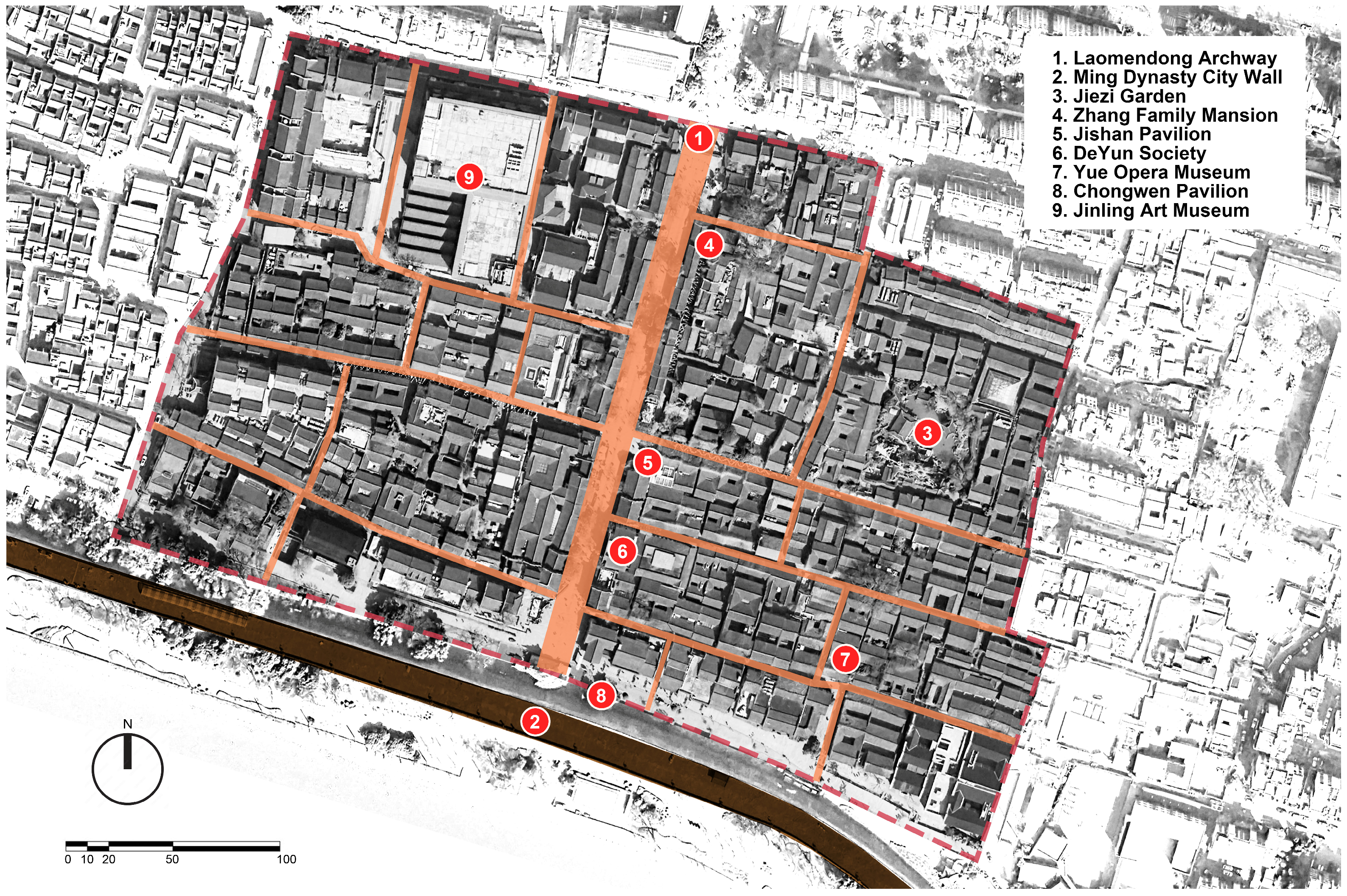
4.2. The Study Site
4.3. Measurement
4.4. Data Collection
4.5. Data Analysis
5. Results
5.1. Multiple-Variable Normality
5.2. Measurement for Historical Landscapes
5.3. Measurement for Spatial Perception
5.4. Measurement for the Overall Model
5.5. Measurement for the Structural Model
6. Conclusions and Discussions
6.1. Summary of the Research Findings
6.2. Practical Implications for the Sustainable Development of Historical District Tourism
6.3. Contributions
6.4. Limitations
Author Contributions
Funding
Data Availability Statement
Acknowledgments
Conflicts of Interest
Appendix A

| Factors | Average | Standard Deviation | Skewness | Kurtosis |
|---|---|---|---|---|
| Historical Landscapes | ||||
| Stylistic Factor | ||||
| SF1.Material | 7.109 | 1.858 | −0.077 | −0.411 |
| SF2.Color | 7.167 | 2.012 | −0.355 | −0.407 |
| SF3.Ornament | 7.696 | 1.601 | −0.484 | −0.028 |
| Symbolic Factor | ||||
| SY1.Landmark | 6.968 | 1.836 | −0.110 | −0.735 |
| SY2.Relic | 7.278 | 2.208 | −0.910 | 0.950 |
| SY3.Sign | 6.656 | 2.336 | −0.159 | −1.039 |
| Spatial Factor | ||||
| SP1.Openness | 7.183 | 2.149 | −0.716 | 0.020 |
| SP2.Scale | 7.031 | 2.297 | −0.583 | −0.418 |
| SP3.Layout | 6.808 | 2.355 | −0.589 | −0.462 |
| Sensation-Seeking | ||||
| SS1.Experience-Seeking | 8.140 | 1.482 | −0.551 | −0.126 |
| SS2.Novelty-Seeking | 8.068 | 1.686 | −0.695 | −0.008 |
| SS3.Boredom Susceptibility | 7.369 | 1.942 | −0.396 | −0.615 |
| Destination Familiarity | ||||
| DF1.Access Frequency | 3.907 | 2.527 | 0.696 | −0.116 |
| DF2.Understanding Level | 3.781 | 2.482 | 0.408 | −0.784 |
| DF3.Familarity Level | 4.292 | 2.398 | 0.454 | −0.676 |
| Visual Perception | ||||
| VP1.Environmental Orientation | 7.006 | 2.202 | −0.598 | −0.304 |
| VP2.Object Recognition | 6.675 | 2.315 | −0.484 | −0.515 |
| VP3.Visual Attention | 6.578 | 2.323 | −0.427 | −0.639 |
| Spatial Perception | ||||
| Navigation and Wayfinding | ||||
| NW1.Navigation | 7.101 | 2.022 | −0.215 | −0.811 |
| NW2.Wayfinding | 6.753 | 2.278 | −0.470 | −0.422 |
| NW3.Movement through spaces | 6.682 | 2.355 | −0.439 | −0.640 |
| Cognitive Mapping | ||||
| CM1.Visualization and mental representation | 6.182 | 2.470 | −0.304 | −0.818 |
| CM2.Sensory information processing | 6.323 | 2.369 | −0.274 | −0.753 |
| CM3.Positional awareness | 6.557 | 2.390 | −0.403 | −0.758 |
| Behavioral Response | ||||
| BR1.Actions and reactions | 6.742 | 2.431 | −0.508 | −0.643 |
| BR2.Emotional responses | 6.570 | 2.388 | −0.320 | −0.672 |
| BR3.Environment engagement | 6.438 | 2.508 | −0.357 | −0.817 |
| Spatial Relationships | ||||
| SR1.Identify objects | 5.768 | 2.461 | −0.134 | −0.906 |
| SR2.Distinguish objects | 6.091 | 2.502 | −0.245 | −0.839 |
| SR3.Relative positions and distances between objects | 6.265 | 2.443 | −0.210 | −0.929 |
References
- Ramineni, S.; Bhardwaj, M.; Tejaswini, H. Placemaking Approach in Revitalizing Cultural Tourism in Temple Towns: Case of Melukote, Karnataka. In Placemaking and Cultural Landscapes; Singh, R.P.B., Niglio, O., Rana, P.S., Eds.; Springer Nature: Singapore, 2023; pp. 135–152. [Google Scholar] [CrossRef]
- Park, E.; Choi, B.K.; Lee, T.J. The role and dimensions of authenticity in heritage tourism. Tour. Manag. 2019, 74, 99–109. [Google Scholar] [CrossRef]
- Xia, S.; Liu, B.; Wang, H. Construction of a Sustainability-Based Building Attribute Conservation Assessment Model in Historic Areas. Buildings 2022, 12, 1346. [Google Scholar] [CrossRef]
- Choi, J.; Park, S. Understanding the Operation of Contextual Compatibility through the Relationships among Heritage Intensity, Context Density, and Regulation Degree. Buildings 2021, 11, 25. [Google Scholar] [CrossRef]
- Gao, J.; Lin, S.S.; Zhang, C. Authenticity, involvement, and nostalgia: Understanding visitor satisfaction with an adaptive reuse heritage site in urban China. J. Destin. Mark. Manag. 2020, 15, 100404. [Google Scholar] [CrossRef]
- Madandola, M.; Boussaa, D. Cultural heritage tourism as a catalyst for sustainable development; the case of old Oyo town in Nigeria. Int. J. Herit. Stud. 2023, 29, 21–38. [Google Scholar] [CrossRef]
- Li, L.; Tang, Y. Towards the Contemporary Conservation of Cultural Heritages: An Overview of Their Conservation History. Heritage 2024, 7, 175–192. [Google Scholar] [CrossRef]
- Lynch, K. The image of the environment. Image City 1960, 11, 1–13. [Google Scholar]
- García-Hernández, M.; De la Calle-Vaquero, M.; Yubero, C. Cultural heritage and urban tourism: Historic city centres under pressure. Sustainability 2017, 9, 1346. [Google Scholar] [CrossRef]
- Avrami, E.; Mason, R. Mapping the issue of values. In Values in Heritage Management: Emerging Approaches and Research Directions; Avrami, E., Macdonald, S., Mason, R., Myers, D., Eds.; Getty Publications: Los Angeles, CA, USA, 2019; pp. 9–33. Available online: https://muse.jhu.edu/pub/331/edited_volume/chapter/2593340 (accessed on 4 April 2020).
- Lew, A.A.; Wu, T.C.; Ni, C.C.; Ng, P.T. Community tourism resilience: Some applications of the scale, change and resilience (SCR) model. In Tourism and Resilience; Slocum, S.L., Kline, C., Eds.; CABI: Wallingford, UK, 2017; pp. 23–31. [Google Scholar] [CrossRef]
- Sánchez, M.L.; Cabrera, A.T.; Del Pulgar, M.L.G. Guidelines from the heritage field for the integration of landscape and heritage planning: A systematic literature review. Landsc. Urban Plan. 2020, 204, 103931. [Google Scholar] [CrossRef]
- Zhang, Y.; Dong, W. Determining minimum intervention in the preservation of heritage buildings. Int. J. Archit. Herit. 2021, 15, 698–712. [Google Scholar] [CrossRef]
- Polo López, C.S.; Troia, F.; Nocera, F. Photovoltaic BIPV Systems and Architectural Heritage: New Balance between Conservation and Transformation. An Assessment Method for Heritage Values Compatibility and Energy Benefits of Interventions. Sustainability 2021, 13, 5107. [Google Scholar] [CrossRef]
- Khorasgani, A.M.; Haghighatbin, M. Regeneration of Historic Cities: Reflections of Its Evolution towards a Landscape Approach. Ph.D. Thesis, Tarbiat Modares University, Tehran, Iran, May 2023. [Google Scholar]
- Zogiani, R. The Sustainability of the Urban form through the Cultural Heritage of the Modernist Architecture in Prishtina: Re-Framing ex. Boro Ramizi Sports and Recreation Center. Ph.D. Thesis, ARIC UNIFE, Ferrara, Italy, 2024. Available online: https://hdl.handle.net/11392/2546053 (accessed on 19 April 2024).
- Dupre, C.; Hupin, D.; Goumou, C.; Béland, F.; Roche, F.; Célarier, T.; Bongue, B. Cognitive function and type of physical activity: Results from the FRéLE longitudinal study. Eur. J. Public Health 2019, 29 (Suppl. 4), ckz185-640. [Google Scholar] [CrossRef]
- Champion, E. Norberg-Schulz: Culture, presence and a sense of virtual place. In The Phenomenology of Real and Virtual Places, 1st ed.; Champion, E., Ed.; Routledge: London, UK, 2018; pp. 144–163. Available online: https://www.taylorfrancis.com/chapters/edit/10.4324/9781315106267-10/norberg-schulz-erik-champion (accessed on 8 November 2018).
- Li, M.; Liu, J.; Lin, Y.; Xiao, L.; Zhou, J. Revitalizing historic districts: Identifying built environment predictors for street vibrancy based on urban sensor data. Cities 2021, 117, 103305. [Google Scholar] [CrossRef]
- Li, J.; Luo, J.; Deng, T.; Tian, J.; Wang, H. Exploring perceived restoration, landscape perception, and place attachment in historical districts: Insights from diverse visitors. Front. Psychol. 2023, 14, 1156207. [Google Scholar] [CrossRef]
- Zhang, H.; Xu, H. A structural model of spatial perception in tourism. Tour. Manag. 2019, 71, 84–98. [Google Scholar] [CrossRef]
- Köksaldı, E.; Turkan, Z. Urban Furniture in Sustainable Historical Urban Texture Landscapes: Historical Squares in the Walled City of Nicosia. Sustainability 2023, 15, 9236. [Google Scholar] [CrossRef]
- Kumar, S.; Chishti, M.D. Psychology of Colors: A Review Study. In Proceedings of the International Conference on Revisiting Management and Business Practices in Dynamic Era, New Delhi, India, 26–27 May 2023; p. 230. Available online: https://iitmjp.ac.in/event/national-conference-2023-on-revisiting-management-and-business-practices-in-dynamic-era/ (accessed on 3 April 2023).
- Askarizad, R.; He, J.; Khotbehsara, E.M. The Legibility Efficacy of Historical Neighborhoods in Creating a Cognitive Map for Citizens. Sustainability 2022, 14, 9010. [Google Scholar] [CrossRef]
- Ashrafi, B.; Kloos, M.; Neugebauer, C. Heritage Impact Assessment, beyond an Assessment Tool: A comparative analysis of urban development impact on visual integrity in four UNESCO World Heritage Properties. J. Cult. Herit. 2021, 47, 199–207. [Google Scholar] [CrossRef]
- Abbasov, I.B. Perception of Images. Modern Trends. In Recognition and Perception of Images: Fundamentals and Applications; Wiley: Hoboken, NJ, USA, 2021; pp. 1–62. [Google Scholar] [CrossRef]
- Hussey, K.A.; Hadyniak, S.E.; Johnston, R.J., Jr. Patterning and development of photoreceptors in the human retina. Front. Cell Dev. Biol. 2022, 10, 878350. [Google Scholar] [CrossRef]
- Taherigorji, H. Brain Dynamic during Landmark-Based Learning Spatial Navigation. Ph.D. Thesis, Sapienza University of Rome, Rome, Italy, August 2020. Available online: https://iris.uniroma1.it/retrieve/e383532a-ce0e-15e8-e053-a505fe0a3de9/Tesi_dottorato_TaheriGorji.pdf (accessed on 22 February 2021).
- Brenner, E.; Smeets, J.B. Depth perception. In Stevens’ Handbook of Experimental Psychology and Cognitive Neuroscience: Sensation, Perception, and Attention, 4th ed.; Wixted, J., Ed.; Wiley: New York, NY, USA, 2018; pp. 385–414. [Google Scholar] [CrossRef]
- Rudenko, A.; Palmieri, L.; Herman, M.; Kitani, K.M.; Gavrila, D.M.; Arras, K.O. Human motion trajectory prediction: A survey. Int. J. Robot. Res. 2020, 39, 895–935. [Google Scholar] [CrossRef]
- Pissaloux, E.; Velázquez, R. On spatial cognition and mobility strategies. In Mobility of Visually Impaired People: Fundamentals and ICT Assistive Technologies; Springer: Berlin/Heidelberg, Germany, 2018; pp. 137–166. [Google Scholar] [CrossRef]
- Dolins, F.L.; Mitchell, R.W. (Eds.) Spatial Cognition, Spatial Perception: Mapping the Self and Space; Cambridge University Press: Cambridge, MA, USA, 2010; pp. 213–236. [Google Scholar]
- Denis, M. Space and Spatial Cognition: A Multidisciplinary Perspective, 1st ed.; Routledge: London, UK, 2017; pp. 55–66. [Google Scholar] [CrossRef]
- Beyes, T.; Holt, R. The topographical imagination: Space and organization theory. Organ. Theory 2020, 1, 2631787720913880. [Google Scholar] [CrossRef]
- Mohler, B.J.; Di Luca, M.; Bülthoff, H.H. Multisensory contributions to spatial perception. In Handbook of Spatial Cognition; Waller, D., Nadel, L., Eds.; American Psychological Association: Washington, DC, USA, 2013; pp. 81–97. [Google Scholar] [CrossRef]
- Miller, S.M. Aldo Rossi: The City as the Locus of Collective Memory and the Making of the Public City in Cold War Italy. Ph.D. Thesis, San José State University, San Jose, CA, USA, August 2017. [Google Scholar]
- Gay, G. Context-Aware Mobile Computing: Affordances of Space, Social Awareness, and Social Influence; Springer Nature: Singapore, 2022; pp. 10–12. [Google Scholar]
- Golestani, N.; Khakzand, M.; Faizi, M. Evaluation of the quality of participatory landscape perception in neighborhoods of cultural landscape to achieve social sustainability. Aestimum 2022, 81, 1–99. [Google Scholar] [CrossRef]
- Sarihan, E. Visibility Model of Tangible Heritage. Visualization of the Urban Heritage Environment with Spatial Analysis Methods. Heritage 2021, 4, 2163–2182. [Google Scholar] [CrossRef]
- Özbek, M.Ö.; Ertürk, F.; Çelebi, T.T.; Kınacı, Y.; Caymaz, G.F.Y. Interpretations and Comparisons of Pedestrian Movement and Land Use Activities in Kadıköy Region Using Space Syntax Method. SAUC—Street Art Urban Creat. 2022, 8, 48–61. [Google Scholar] [CrossRef]
- Curtin, K.; Montello, D.R. (Eds.) Collective Spatial Cognition: A Research Agenda, 1st ed.; Routledge: London, UK, 2024; pp. 154–196. [Google Scholar]
- Erdogan, E. Urban Aesthetics; Visual Quality Evaluation of “Konya Türbeönü” the Historical Urban Square. Open House Int. 2016, 41, 43–50. [Google Scholar] [CrossRef]
- Carmona, M. Public Places Urban Spaces: The Dimensions of Urban Design; Routledge: London, UK, 2021; pp. 1–53. [Google Scholar] [CrossRef]
- El Ghandour, S. Towards More Pedestrian-Friendly Streets in Cairo. Master’s Thesis, The American University in Cairo, New Cairo, Egypt, 2016. Available online: https://fount.aucegypt.edu/etds/593 (accessed on 18 June 2020).
- Cianchino, G.; Masciotta, M.G.; Verazzo, C.; Brando, G. An Overview of the Historical Retrofitting Interventions on Churches in Central Italy. Appl. Sci. 2023, 13, 40. [Google Scholar] [CrossRef]
- Fang, Q.; Fang, H.; Xi, X. Practice and Exploration of Experiential Theme Landscape Design in Urban Historic Blocks: A Case Study of Shengjin Tower Folk Custom Historical Block in Nanchang. J. Landsc. Res. 2023, 15, 35–42, 46. [Google Scholar] [CrossRef]
- UNESCO. World Heritage and Contemporary Architecture—Managing the Historic Urban Landscape; UNESCO: Paris, France, 2005. [Google Scholar]
- Rey-Perez, J.; Siguencia Ávila, M.E. Historic urban landscape: An approach for sustainable management in Cuenca (Ecuador). J. Cult. Herit. Manag. Sustain. Dev. 2017, 7, 308–327. [Google Scholar] [CrossRef]
- Ching, F.D. Architecture: Form, Space, and Order, 5th ed.; John Wiley & Sons: New York, NY, USA, 2023; pp. 223–232. [Google Scholar]
- Sandaker, B.N.; Eggen, A.P.; Cruvellier, M.R. The Structural Basis of Architecture, 3rd ed.; Routledge: London, UK, 2019; pp. 18–44. [Google Scholar] [CrossRef]
- Nilam, W. Fusion of Ornamental Art and Architectural Design: Exploring the Interplay and Creation of Unique Spatial Experiences. Stud. Art Archit. 2023, 2, 10–27. [Google Scholar] [CrossRef]
- Zink, S. polychromy, architectural, Greek and Roman. In Oxford Research Encyclopedia of Classics; Oxford University Press: Oxford, UK, 2019. [Google Scholar] [CrossRef]
- Jester, T.C. Twentieth-Century Building Materials: History and Conservation; Getty Publications: Princeton, NJ, USA, 2016; pp. 353–355. [Google Scholar]
- Camposampiero, M.F. The Direction of Our Gaze: Attention in Wolff’s Psychology and Aesthetics. Odradek. Stud. Philos. Lit. Aesthet. New Media Theor. 2021, 7, 67–114. [Google Scholar]
- El-Shafey, F.K.; Mohamed, E.L.; Fouad, A.M.; Elkhayat, A.S.; Hassabo, A.G. The Influence of Nature on Art and Graphic Design: The Connection with Raw Materials and Prints. J. Text. Color. Polym. Sci. 2024, 21, 385–396. [Google Scholar] [CrossRef]
- Doležalová, A.; Holec, R. Czechoslovakia: Opening Doors to the West. In Behind the Iron Curtain: Economic Historians during the Cold War, 1945–1989; Doležalová, A., Albrecht, C., Eds.; Palgrave Macmillan: Cham, Switzerland; London, UK, 2023; pp. 89–126. [Google Scholar] [CrossRef]
- Cazzani, A.; Zerbi, C.M.; Brumana, R.; Lobovikov-Katz, A. Raising awareness of the cultural, architectural, and perceptive values of historic gardens and related landscapes: Panoramic cones and multi-temporal data. Appl. Geomat. 2022, 14 (Suppl. S1), 97–130. [Google Scholar] [CrossRef]
- Krey, N. Enough Is Enough! Understanding Environmentally Driven Multisensory Experiences. Ph.D. Thesis, Louisiana Tech University, Ruston, LA, USA, 2016. Available online: https://www.proquest.com/openview/3785873fa829ff6d968a58ecec2e5970/1?pq-origsite=gscholar&cbl=18750 (accessed on 4 August 2016).
- Bryant, C.; Frazier, A.D. Developing visual-spatial thinking in youth using sensorimotor experiences: Approaches from a Piagetian cognitive framework. J. Pedagog. Res. 2019, 3, 99–112. [Google Scholar] [CrossRef]
- Wen, L.; Kenworthy, J.; Marinova, D. Higher Density Environments and the Critical Role of City Streets as Public Open Spaces. Sustainability 2020, 12, 8896. [Google Scholar] [CrossRef]
- Peer, M.; Brunec, I.K.; Newcombe, N.S.; Epstein, R.A. Structuring knowledge with cognitive maps and cognitive graphs. Trends Cogn. Sci. 2021, 25, 37–54. [Google Scholar] [CrossRef]
- Brügger, A.; Richter, K.F.; Fabrikant, S.I. How does navigation system behavior influence human behavior? Cogn. Res. Princ. Implic. 2019, 4, 5. [Google Scholar] [CrossRef]
- Weisberg, S.M.; Schinazi, V.R.; Newcombe, N.S.; Shipley, T.F.; Epstein, R.A. Variations in cognitive maps: Understanding individual differences in navigation. J. Exp. Psychol. Learn. Mem. Cogn. 2014, 40, 669. [Google Scholar] [CrossRef]
- Lin, Z.; Chen, Y.; Filieri, R. Resident-tourist value co-creation: The role of residents’ perceived tourism impacts and life satisfaction. Tour. Manag. 2020, 76, 103942. [Google Scholar] [CrossRef]
- Zhang, T.; Xiao, X.; He, F. The dynamic identity of Chinese urban heritage space-Laomendong as a case study. In Proceedings of the 3rd International Conference on Urban Engineering and Management Science (ICUEMS 2022), Wuhan, China, 21–23 January 2022. [Google Scholar] [CrossRef]
- Zhang, T.; He, F.; Ye, J.; Wang, D. Decoding Morphological Evolution of Urban Historical Area Case from Laomendong, Nanjing. In Proceedings of the 6th International Conference on Architecture and Civil Engineering (ICACE 2022), Kuala Lumpur, Malaysia, 18 August 2022. [Google Scholar] [CrossRef]
- Wu, C. Analysis of Spatial Structure of Historical Districts in Laomendong of Nanjing. Master’s Thesis, Xi’an University of Architecture and Technology, Xi’an, China, 2013. [Google Scholar] [CrossRef]
- Chen, C.F.; Tsai, D. How destination image and evaluative factors affect behavioral intentions. Tour. Manag. 2007, 28, 1115–1122. [Google Scholar] [CrossRef]
- Mardia, K.V. Measures of multivariate skewness and kurtosis with applications. Biometrika 1970, 57, 519–530. [Google Scholar] [CrossRef]
- Satorra, A.; Bentler, P.M. Corrections to test statistics and standard errors in covariance structure analysis. In Latent Variables Analysis: Applications for Developmental Research; von Eye, A., Clogg, C.C., Eds.; Sage Publications: New York, NY, USA, 1994; pp. 399–419. Available online: https://psycnet.apa.org/record/1996-97111-016 (accessed on 29 August 1994).
- Maydeu-Olivares, A. Assessing the size of model misfit in structural equation models. Psychometrika 2017, 82, 533–558. [Google Scholar] [CrossRef] [PubMed]
- Hair, J.F.; Black, W.C.; Babin, B.J.; Anderson, R.E. Multivariate Data Analysis, 7th ed.; Prentice Hall: Hoboken, NJ, USA, 2010; pp. 399–419. Available online: https://www.drnishikantjha.com/papersCollection/Multivariate%20Data%20Analysis.pdf (accessed on 23 February 2009).
- Fornell, C.; Larcker, D.F. Evaluating structural equation models with unobservable variables and measurement error. J. Mark. Res. 1981, 18, 39–50. [Google Scholar] [CrossRef]
- Perrotta, G. The Reality Plan and the Subjective Construction of One’s Perception: The Strategic Theoretical Model among Sensations, Perceptions, Defence Mechanisms, Needs, Personal Constructs, Beliefs System, Social Influences and Systematic Errors. J. Clin. Res. Rep. 2019, 1, 1–9. [Google Scholar] [CrossRef]
- Maples-Keller, J.L.; Berke, D.S. Sensation seeking. In Encyclopedia of Personality and Individual Differences; Springer: Berlin/Heidelberg, Germany, 2020; pp. 4830–4833. Available online: https://link.springer.com/content/pdf/10.1007/978-3-319-24612-3_1108.pdf (accessed on 1 January 2020).
- Alves, S. Understanding intangible aspects of cultural heritage: The role of active imagination. Hist. Environ. Policy Pract. 2018, 9, 207–228. [Google Scholar] [CrossRef]
- Nowacki, M. Heritage Interpretation and Sustainable Development: A Systematic Literature Review. Sustainability 2021, 13, 4383. [Google Scholar] [CrossRef]
- Dai, T.; Zheng, X.; Yan, J. Contradictory or aligned? The nexus between authenticity in heritage conservation and heritage tourism, and its impact on satisfaction. Habitat Int. 2021, 107, 102307. [Google Scholar] [CrossRef]
- Armstrong, P.J.; Kapp, P.H. Preserving the past or past preserving: Sustaining the legacy of postmodern museum architecture. Built Herit. 2022, 6, 12. [Google Scholar] [CrossRef]
- Abrar, N. Contextuality and Design Approaches in Architecture. Int. J. Educ. 2021, 2, 7043–7051. [Google Scholar]
- Ranne, J. Designing for Multi-Sensory Experiences in the Built Environment. Master’s Thesis, Aalto University, Espoo, Finland, 2019. Available online: https://aaltodoc.aalto.fi/server/api/core/bitstreams/fb253b29-d4bd-4e7e-9e8b-bbbd7cb89397/content (accessed on 1 December 2019).
- Wolfe, C.R. Sustaining a City’s Culture and Character: Principles and Best Practices; Rowman & Littlefield Publishers: London, UK, 2021; pp. 171–216. [Google Scholar]
- Savitri, M.; Amalia, F. Technology and AI Implementation in Heritage Adaptive Reuse as Strategy for Sustainable and Smart City. IOP Conf. Ser. Earth Environ. Sci. 2024, 1324, 012056. [Google Scholar] [CrossRef]
- Gallou, E.; Fouseki, K. Managing participatory heritage for enhancing social well-being. In Routledge Handbook of Sustainable Heritage, 1st ed.; Routledge: London, UK, 2022; pp. 87–103. Available online: https://www.taylorfrancis.com/chapters/edit/10.4324/9781003038955-9/managing-participatory-heritage-enhancing-social-well-being-eirini-gallou-kalliopi-fouseki (accessed on 29 July 2022).
- Calò, S.; Malè, M.; Tamburrino, E. Guidelines of Modern Management of Historic Ruins: Best Practices Handbook; Politechnika Lubelska: Lublin, Poland, 2020; pp. 8–11. Available online: http://bc.pollub.pl/dlibra/publication/13867/edition/13538 (accessed on 22 September 2020).
- Dawson, P.; Mäkelä, M. The Routledge Companion to Narrative Theory, 3rd ed.; Routledge: London, UK, 2023; pp. 104–116. Available online: https://www.taylorfrancis.com/books/edit/10.4324/9781003100157/routledge-companion-narrative-theory-paul-dawson-maria-m%C3%A4kel%C3%A4 (accessed on 18 July 2022).
- Tussyadiah, I.P.; Wang, D.; Jung, T.H.; Tom Dieck, M.C. Virtual Reality, Presence, and Attitude Change: Empirical Evidence from Tourism. Tour. Manag. 2018, 66, 140–154. [Google Scholar] [CrossRef]
- Mooney, P. Planting Design: Connecting People and Place; Routledge: London, UK, 2019; pp. 156–275. [Google Scholar] [CrossRef]
- Prebensen, N.K.; Woo, E.; Chen, J.S.; Uysal, M. Motivation and Involvement as Antecedents of the Perceived Value of the Destination Experience. J. Travel Res. 2017, 56, 145–157. [Google Scholar] [CrossRef]
- Lucchi, E. Regenerative Design of Archaeological Sites: A Pedagogical Approach to Boost Environmental Sustainability and Social Engagement. Sustainability 2023, 15, 3783. [Google Scholar] [CrossRef]
- Adaptive Reuse of the Urban Built Environment and Design Intervention Strategies. Available online: http://pea.lib.pte.hu/handle/pea/34283 (accessed on 12 July 2022).
- Lanz, F.; Pendlebury, J. Adaptive reuse: A critical review. J. Archit. 2022, 27, 441–462. [Google Scholar] [CrossRef]

| Factors | Variables | Items | Explanation | References |
|---|---|---|---|---|
| Stylistic Factors | Material | Stone, wood, brick | Flagstone road, whitewashed brick walls, wooden columns with stone bases, and wood-carved decorations on doors and windows | [65,66] |
| Color | Gray, white, black, red, yellow | Buildings are usually white walls and gray tiles with bright ornamentation | ||
| Ornament | Wooden carvings, wall reliefs, wall murals, window grilles, door head | Reflect the unique “Jinling culture”, incorporating traditional craftsmanship and aesthetic concepts | [67] | |
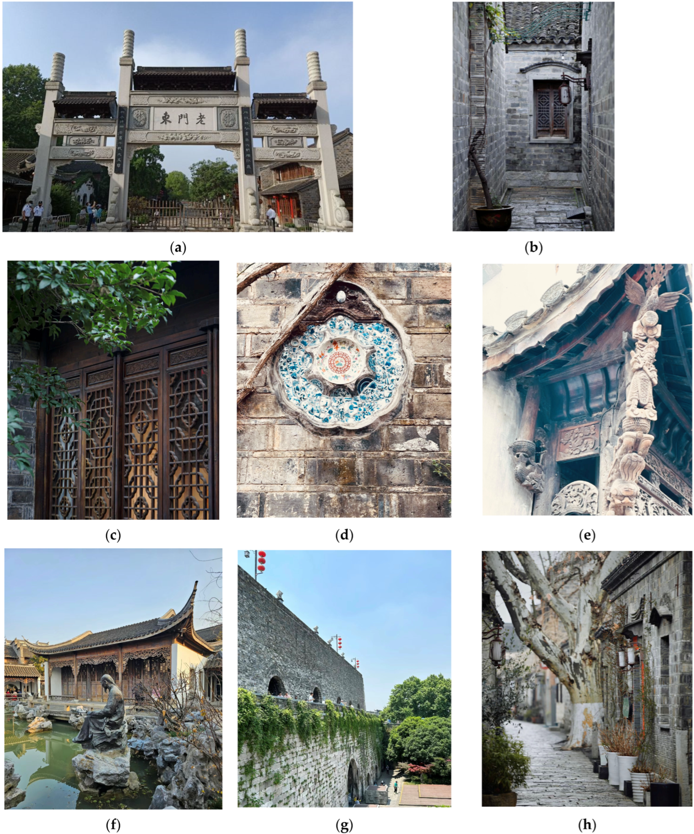
| Symbolic Factors | Landmark | Laomendong Archway | Buildings or structures of historical significance | [65] |
| Relic | Ming Dynasty Ancient City Wall, Jiezi Garden, Jishan Pavilion | |||
| Sign | Ancient well and trees, bronze statue, relic interpretation signs | |||
| Spatial Factors | Openness | Fully open | Public space | [66,67] |
| Semi-open | “U”-shaped and “L”-shaped courtyards | |||
| Fully enclosed | Square-shaped and four-sided enclosed courtyards | |||
| Scale | Height of building | Limited to 1–2 stories, with eave heights of 2.8 to 3.3 m on the first floor and around 6 m on the second, capped at a total height of 7.5 m | ||
| Depth of building | Primarily between 6 and 9 m, with most ranging from 7 to 8 m | |||
| Width of building | Mainly falls within 7 to 9 m and 11 to 12 m. | |||
| Ratio of building to courtyard spaces | Typically 1:2 | |||
| Dimension of street | The width of the streets primarily ranges from 3 to 5 m, with a width-to-height ratio consistently at or below 1 | |||
| Layout | Square-shaped courtyards |  | ||
| “U”-shaped courtyards |  | |||
| “L”-shaped courtyards |  | |||
| Four-sided enclosed courtyards |  |
| Variable | Items | Occurrence | Proportion |
|---|---|---|---|
| Survey Respondent | Nanjing Citizen | 69 | 11.2% |
| Tourist | 547 | 88.8% | |
| Gender | Male | 300 | 48.7% |
| Female | 316 | 51.3% | |
| Age | Under 20 | 15 | 2.4% |
| 20–30 | 479 | 77.8% | |
| 31–40 | 29 | 4.7% | |
| Above 40 | 93 | 15.1% |
| Variable/Items | Loading | CR | AVE |
|---|---|---|---|
| Stylistic Factor | 0.884 | 0.723 | |
| ST1.Material | 0.871 | ||
| ST2.Color | 0.990 | ||
| ST3.Ornament | 0.657 | ||
| Symbolic Factor | 0.820 | 0.607 | |
| SY1.Landmark | 0.722 | ||
| SY2.Relic | 0.672 | ||
| SY3.Sign | 0.921 | ||
| Spatial Factor | 0.918 | 0.790 | |
| SP1.Openness | 0.834 | ||
| SP2.Scale | 0.981 | ||
| SP3.Layout | 0.843 |
| Stylistic Factor | Symbolic Factor | Spatial Factor | |
|---|---|---|---|
| Stylistic Factor | 0.851 | ||
| Symbolic Factor | 0.607 | 0.779 | |
| Spatial Factor | 0.371 | 0.293 | 0.889 |
| Variable/Items | EFA (n = 308) | CFA (n = 308) | ||||
|---|---|---|---|---|---|---|
| Loading | Eigenvalue | Variance Explained | Loading | CR | AVE | |
| Behavioral Response | 4.030 | 33.583 | 0.880 | 0.714 | ||
| BR1.Actions and reactions | 0.864 | 0.814 | ||||
| BR2.Emotional responses | 0.896 | 0.977 | ||||
| BR3.Environment engagement | 0.829 | 0.724 | ||||
| Cognitive Mapping | 2.072 | 17.263 | 0.876 | 0.706 | ||
| CM1.Visualization and mental representation | 0.806 | 0.730 | ||||
| CM2.Sensory information processing | 0.926 | 0.988 | ||||
| CM3.Positional awareness | 0.872 | 0.781 | ||||
| Spatial Relationships | 1.778 | 14.813 | 0.836 | 0.643 | ||
| SR1.Identify objects | 0.908 | 0.989 | ||||
| SR2.Distinguish objects | 0.885 | 0.811 | ||||
| SR3.Relative positions and distances between objects | 0.735 | 0.541 | ||||
| Navigation and Wayfinding | 1.218 | 10.151 | 0.810 | 0.595 | ||
| NW1.Navigation | 0.809 | 0.960 | ||||
| NW2.Wayfinding | 0.808 | 0.661 | ||||
| NW3.Movement through spaces | 0.771 | 0.653 | ||||
| Variable /Items | AVE Test | FLC | |||
|---|---|---|---|---|---|
| Navigation and Wayfinding | Cognitive Mapping | Behavioral Response | Spatial Relationships | ||
| Navigation and Wayfinding | 0.771 | True | |||
| Cognitive Mapping | 0.189 | 0.840 | True | ||
| Behavioral Response | 0.431 | 0.150 | 0.845 | True | |
| Spatial Relationships | 0.284 | 0.168 | 0.184 | 0.802 | True |
| Variable/Items | Loading | CR | AVE | Alpha (α) |
|---|---|---|---|---|
| Stylistic Factor | 0.887 | 0.728 | 0.872 | |
| SF1.Material | 0.882 | |||
| SF2.Color | 0.975 | |||
| SF3.Ornament | 0.674 | |||
| Symbolic Factor | 0.811 | 0.592 | 0.807 | |
| SY1.Landmark | 0.795 | |||
| SY2.Relic | 0.638 | |||
| SY3.Sign | 0.859 | |||
| Spatial Factor | 0.918 | 0.790 | 0.793 | |
| SP1.Openness | 0.834 | |||
| SP2.Scale | 0.981 | |||
| SP3.Layout | 0.843 | |||
| Visual Perception | 0.837 | 0.640 | 0.826 | |
| VP1.Environmental Orientation | 0.998 | |||
| VP2.Object Recognition | 0.670 | |||
| VP3.Visual Attention | 0.690 | |||
| Sensation-Seeking | 0.852 | 0.665 | 0.823 | |
| SS1.Experience-Seeking | 0.903 | |||
| SS2.Novelty-Seeking | 0.917 | |||
| SS3.Boredom Susceptibility | 0.583 | |||
| Destination Familiarity | 0.882 | 0.717 | 0.874 | |
| DF1.Access Frequency | 0.998 | |||
| DF2.Understanding Level | 0.800 | |||
| DF3.Familarity Level | 0.717 | |||
| Spatial Perception | 0.829 | 0.529 | 0.770 | |
| SP1. Navigation and Wayfinding | 0.825 | |||
| SP2.Cognitive Mapping | 0.783 | |||
| SP3.Behavioral Response | 0.749 | |||
| SP4.Spatial Relationships | 0.511 |
| Variable /Items | AVE Test | FLC | ||||||
|---|---|---|---|---|---|---|---|---|
| Stylistic Factor | Symbolic Factor | Spatial Factor | Visual Perception | Sensation-Seeking | Destination Familiarity | Spatial Perception | ||
| Stylistic Factor | 0.816 | True | ||||||
| Historical Factor | 0.385 | 0.847 | True | |||||
| Spatial Factor | 0.570 | 0.412 | 0.853 | True | ||||
| Visual Perception | 0.424 | 0.523 | 0.607 | 0.770 | True | |||
| Sensory Seeking | 0.360 | 0.316 | 0.371 | 0.293 | 0.889 | True | ||
| Destination Familiarity | 0.401 | 0.566 | 0.476 | 0.457 | 0.266 | 0.800 | True | |
| Spatial Perception | 0.319 | 0.622 | 0.454 | 0.580 | 0.277 | 0.525 | 0.727 | True |
| Hypothesis | Route | Estimate | T-Value |
|---|---|---|---|
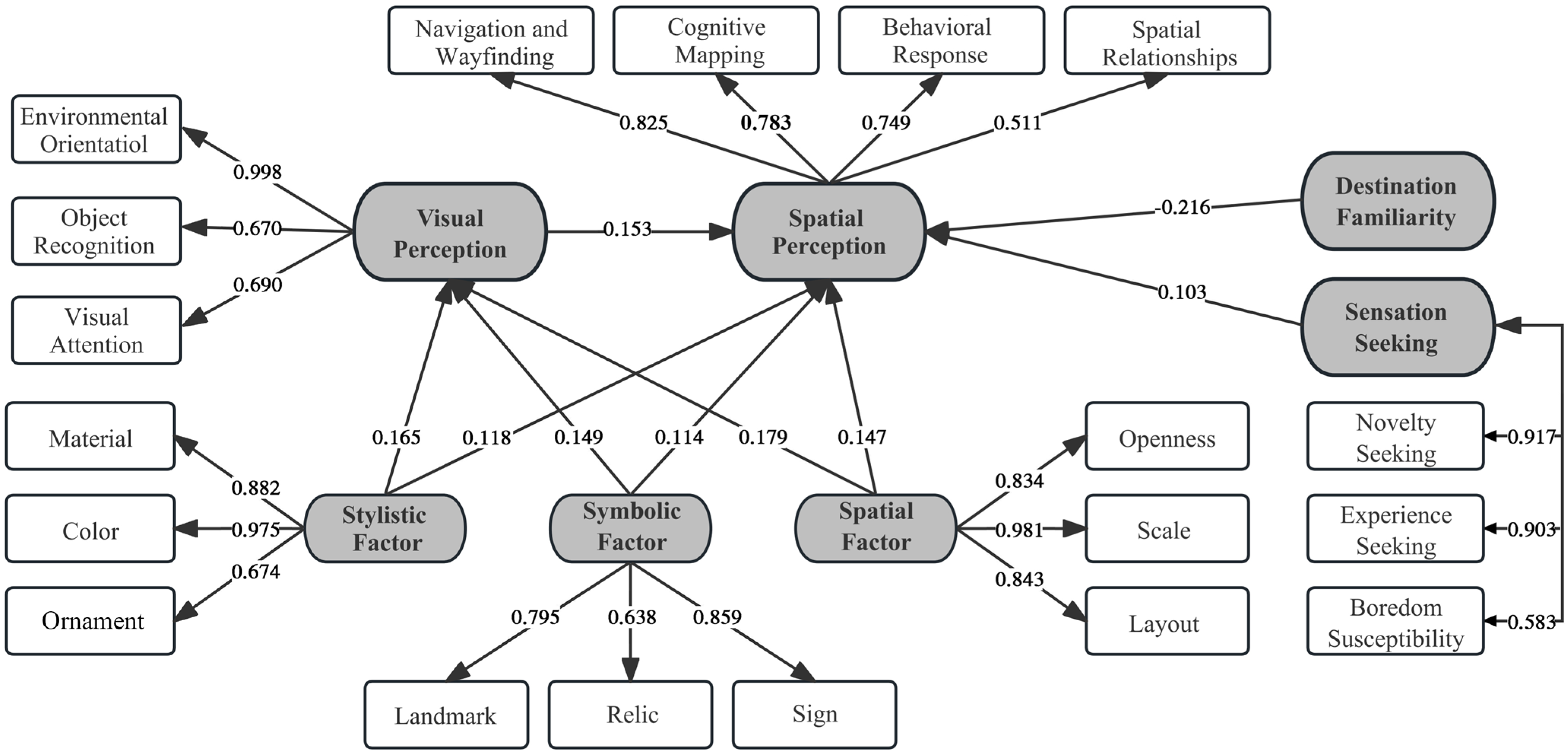
| H1a | Stylistic Factor→Visual Perception | 0.165 | 10.745 *** |
| H2a | Symbolic Factor→Visual Perception | 0.149 | 11.867 *** |
| H3a | Spatial Factor→Visual Perception | 0.179 | 6.911 *** |
| H1b | Stylistic Factor→Spatial Perception | 0.118 | 9.756 *** |
| H2b | Symbolic Factor→Spatial Perception | 0.114 | 14.917 *** |
| H3b | Spatial Factor→Spatial Perception | 0.147 | 6.159 *** |
| H4 | Visual Perception→Spatial Perception | 0.153 | 16.567 *** |
| H5 | Sensation-Seeking→Spatial Perception | 0.103 | 10.139 *** |
| H6 | Destination Familiarity→Spatial Perception | −0.216 | −18.5 *** |
Disclaimer/Publisher’s Note: The statements, opinions and data contained in all publications are solely those of the individual author(s) and contributor(s) and not of MDPI and/or the editor(s). MDPI and/or the editor(s) disclaim responsibility for any injury to people or property resulting from any ideas, methods, instructions or products referred to in the content. |
© 2024 by the authors. Licensee MDPI, Basel, Switzerland. This article is an open access article distributed under the terms and conditions of the Creative Commons Attribution (CC BY) license (https://creativecommons.org/licenses/by/4.0/).
Share and Cite
Shao, L.; Ma, P.; Zhou, Z. Research on the Impact of Landscape Planning on Visual and Spatial Perception in Historical District Tourism: A Case Study of Laomendong. Land 2024, 13, 1134. https://doi.org/10.3390/land13081134
Shao L, Ma P, Zhou Z. Research on the Impact of Landscape Planning on Visual and Spatial Perception in Historical District Tourism: A Case Study of Laomendong. Land. 2024; 13(8):1134. https://doi.org/10.3390/land13081134
Chicago/Turabian StyleShao, Lingfang, Pengfei Ma, and Zijin Zhou. 2024. "Research on the Impact of Landscape Planning on Visual and Spatial Perception in Historical District Tourism: A Case Study of Laomendong" Land 13, no. 8: 1134. https://doi.org/10.3390/land13081134
APA StyleShao, L., Ma, P., & Zhou, Z. (2024). Research on the Impact of Landscape Planning on Visual and Spatial Perception in Historical District Tourism: A Case Study of Laomendong. Land, 13(8), 1134. https://doi.org/10.3390/land13081134