Abstract
Geochemical mapping is the base of knowledge needed to determine the critical contents of potential toxic elements and the potentially hazardous regions on the planet. This work presents maps of baseline values of chemical elements in the soils of Sal Island (Cape Verde) and the assessment of their ecological and human health risks. According to the results, Ba, Co, Ni, and V baseline values are above the international guidelines for agricultural and residential proposed uses. Arsenic in the soil overlying the Ancient Eruptive Complex shows a high potential ecological risk factor. It is not clear if high As contents in soils have a geogenic or anthropogenic source. Hazard indexes (HI) were calculated for children and adults. For children, HI is higher than 1 for Co, Cr, and Mn, indicating potential non-carcinogenic risk. These elements are present in high content in soils covering Quaternary sediments, the Monte Grande-Pedra Lume Formation, and the Ancient Eruptive Complex, inducing belief in a geogenic source. For the other elements and for adults, there is no potential non-carcinogenic risk. Cancer risk (CR) was calculated for As, Cd, Cr, and Ni exposures for adults and children, and the results are mainly lower than the carcinogenic target risk value, indicating no cancer risk. Only in a few soil samples are CR results slightly higher than the carcinogenic target risk of 1 × 10⁻⁴ 2 × 10⁻⁶ for adults exposed to Cr by inhalation. It is important to emphasize that these results of the health risk associated with exposure are likely to overestimate the bioavailable fractions of the elements in the soil once it is used as aqua regia instead of physiological fluids to digest the soil. However, since measured concentrations of potential toxic elements in soil reveal that they can be harmful to both the environment and human health, regional activities such as agriculture or water exploitation must be controlled by competent authorities. These conclusions highlight the insights and the applicability of soil geochemistry surveys for future policy progress, which are particularly relevant in developing countries like the Cape Verde archipelago.
1. Introduction
Environmental change on the Earth is as old as the planet itself. However, in the mid-twentieth century, our planet entered a distinct new stage with no precedent in its long history, which some have identified as the Anthropocene [1,2]. Evidence is mounting that life, as we have experienced it for the last ten millennia, is changing very fast. The future of our civilization depends on human health, flourishing natural systems, and the wise stewardship of natural resources. With natural systems being degraded to an extent not seen before in human history, both our health and that of our planet are in danger. Well-known impacts of human behavior include shifting the pattern of diseases and compromised availability of food, water, and sanitation conditions. Moreover, changes in river basins and coastal environments are affecting the safety of human survival worldwide. The present status of the environment has made geochemical mapping an urgency in a range of countries, given the applicability of the resulting geochemical databases, such as the recognition of ecological and human health risk regions (e.g., [3,4,5,6,7,8,9,10,11,12,13,14]).
Geochemical surveys are especially important in developing countries like Cape Verde, where intervention limits for the near-surface environment are not yet established. Considering this lack of information, a high-density (approx. 1/3 km2) soil campaign was performed in the Sal Island of Cape Verde archipelago, following the guidelines proposed by the International Geological Correlation Program (IGCP) Project 259 [15]. Soils are important natural resources, in particular in areas of limited rainfall when weathering profiles are very thin or nonexistent. Knowledge of the geochemistry of the near-surface environment is essential, as it contributes to the improvement of the nutritional status of the population and helps to understand the causes of some endemic diseases, which can be related to chemical element exposure. Some elements can naturally accumulate on soils in concentrations that are toxic to surface ecosystems and to humans. The dispersion of these elements in the environment is mainly carried out by water and air, which are vehicles linking the inorganic environment to life.
This study aims to achieve the following: (i) decipher the sources of metal(oid)s by coupling geochemical information with mapped geology using statistical analysis; and (ii) evaluate the ecological risk and health risk for children and adults. It will provide a deeper and wider understanding of the applicability of soil geochemistry surveys for environmental and human health protection and for future policy development, which are mainly relevant in developing countries.
2. Cape Verde Archipelago and Sal Island
The archipelago of Cape Verde is located 695 km west of Senegal, on the African western shore. It is composed of ten islands, nine of which are inhabited. Sal Island has an area of 216 km2, a maximum length of 30 km, and a population of around 14,800 inhabitants, according to INE (2010, see www.ine.cv (accessed on 30 May 2024)). The island is served by an international airport, located close to the biggest city of the island (Espargos), that was inaugurated in 1939 and presently receives approximately half a million passengers annually.
Despite being of volcanic origin, Sal Island is flat, and non-volcanic units crop out in extensive areas. The highest elevation on the island is 406 m and is called Monte Grande. It is a very arid territory with little vegetation. On average, there are around 350 days of sunshine per year, and rainfall is rare.
The soil types that occur on Sal Island [16], according to WRB [17], reveal little or no profile differentiation. Camisoles (moderately developed), fluvisols (stratified fluviatile, marine, or lacustrine sediments), and arenosols (sandy) occurred. Also, soils with limitations to root growth are common on the island, such as leptosols (thin or with many coarse fragments), solonchaks (high concentrations of soluble salts), and solonetz (with a high content of exchangeable Na). The island also has soils distinguished by Al chemistry, such as andosols (allophanes and/or Al humus complexes).
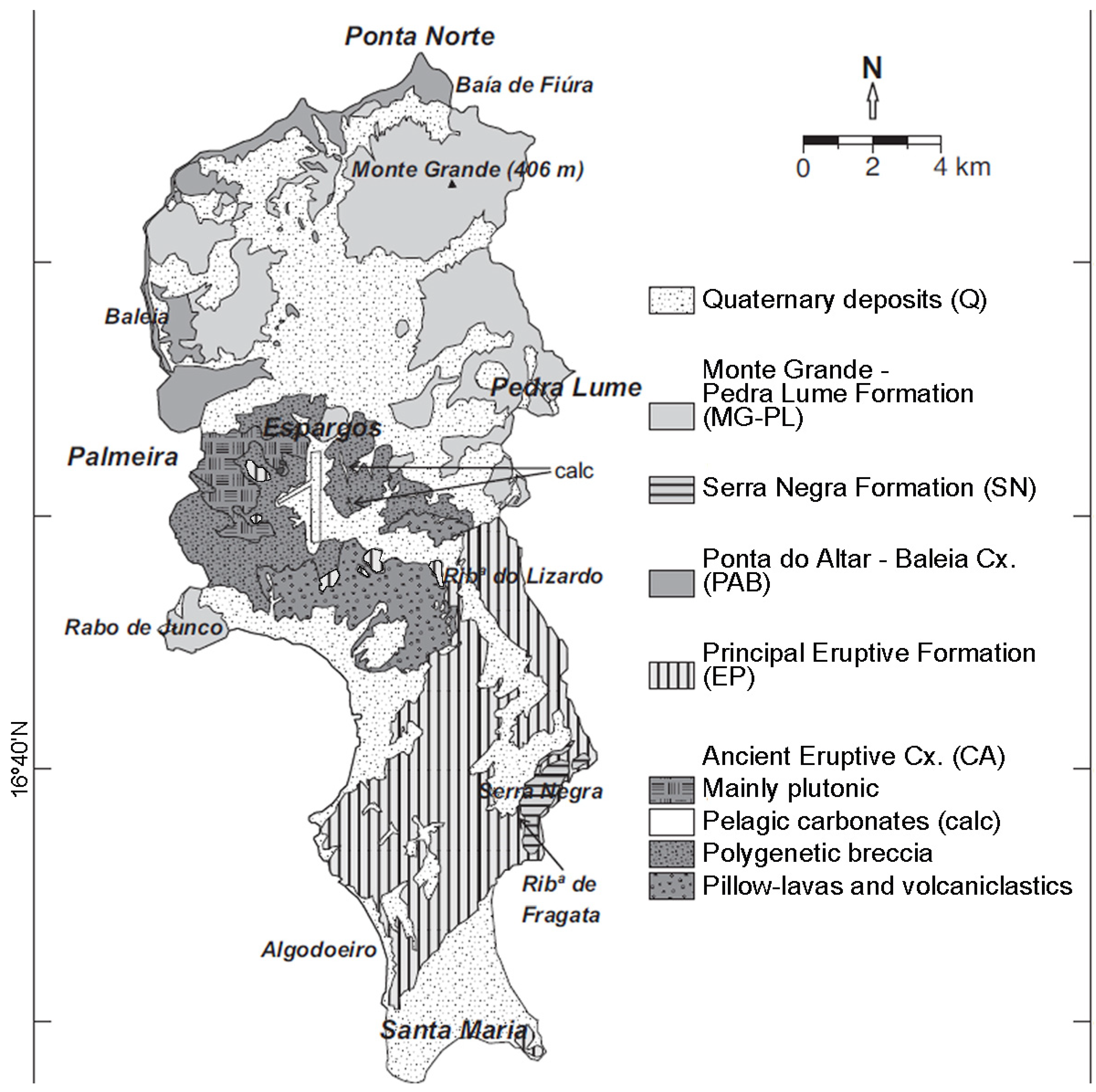
The island of Sal (Figure 1 and Table 1) is one of the oldest in the archipelago, with shield-building volcanic activity occurring approximately 16 million years ago [18,19]. The oldest rocks, constituting the basement of Sal Island, belong to the Ancient Eruptive Complex. They have been attributed to the Miocene based on geochronological and paleontological data [19,20,21]. This complex, which is exhumed in the central western region, is formed mainly by submarine lavas and hyaloclastites with a dominant alkali basaltic to trachytic composition. Intrusive bodies with diverse compositions, including syenites, gabbro, and pyroxenites, may constitute sub-circular structures intruded in old lava flows of the Ancient Eruptive Complex [21,22]. Some of these intrusive rocks were also associated with the younger volcanic units of the Principal Eruptive Formation [19]. In addition, carbonate dolomitic rocks with Miocene and reworked Oligocene–Miocene microfossils occur [19,20].

Figure 1.
Geological map of Sal Island from Ramalho et al., 2010 [19].
In a wide portion of the central to southern portion of Sal Island, broadly oriented NE–SW, crop out the Principal Eruptive Formation. It stands on the Ancient Eruptive Complex and comprises two distinct series that record an evolution from submarine to subaerial volcanic activity [21]. According to Ramalho [19], it is probable that the Principal Eruptive Formation is partially coeval with the Ponta do Altar-Baleia Complex, which presently crops out in the northern and north-western portions of Sal. The Principal Eruptive Formation and the Ponta do Altar-Baleia Formation are exposed in distinct regions of the island and were independently dated by different authors [18,21], but they can be associated with a common long period of volcanic activity ranging from 14 to 16 Ma [19]. Compositionally, they both include alkali basalts and nephelinites [21,22]. Nearshore to shallow marine sedimentary units also occur intercalated in the Ponta do Altar-Baleia and between the Principal Eruptive Formation and Serra Negra Formation (Fragata Formation).
In the south-western part of Sal Island, approximately 6 km to the north of Santa Maria, the Serra Negra Formation records a lava delta with NW dipping forests [19], where basaltic volcanic units progressively evolve from submarine to subaerial character [21]. This volcanic unit was formed at ~5.5 Ma [18,22].
After a period of volcanic quiescence, when Plio–Pleistocene sedimentary units were deposited [23], the youngest eruptive units ascribed to the Monte Grande-Pedra Lume Formation were extruded [21]. The geological unit, associated with multiple cones that are presently preserved in the northern and north-eastern parts of the island but also in a small peninsula some 5 km SW of Espargos, is considered to be Pleistocene (~1.0–0.6 Ma) [18,21].

Table 1.
Geological units, main exposure regions, rock type, lithology, and primary minerals of Sal Island (based on Torres et al. [21,22] and Ramalho et al. [19]).
Table 1.
Geological units, main exposure regions, rock type, lithology, and primary minerals of Sal Island (based on Torres et al. [21,22] and Ramalho et al. [19]).
| Geological Formation | Cropping-Out Regions | Rock Type | Lithology | Primary Minerals |
|---|---|---|---|---|
| Ancient Eruptive Complex (CA) | Central western | Submarine lava flows, breccia; dykes and plutonic masses; and intercalated sedimentary units | Basalts and occasional dolomitic limestone | Olivine, pyroxene, feldspar, magnetite, ilmenite, sanidine, nepheline, leucite, dolomite, and phyllosilicates |
| Principal Eruptive Formation (EP) | Continuous strip in the central to southern portion | Submarine (lower series) and subaerial (upper series) extrusive rocks | Alkali basalt and nephelinites | Olivine, pyroxene, alkaline feldspar, nepheline, leucite, carbonates, oxides, and apatite |
| Ponta do Altar-Baleia Complex (PAB) and intercalated sedimentary units | Mostly northern and north-western | Subaerial (lower portion) and submarine (upper) lava flows; volcanic feeding vents; and nearshore and shallow marine deposits | Alkali basalt and nephelinites; Conglomerates and calcarenites | Olivine, pyroxenes, alkaline feldspar, nepheline, leucite, carbonates, oxides, apatite, quartz, and phyllosilicates |
| Serra Negra Formation (SN) | Restricted south-eastern areas | Lava delta | Alkali basalt and nephelinites | Olivine, pyroxenes, alkaline feldspar, nepheline, leucite, carbonates, oxides, and apatite |
| Monte Grande-Pedra Lume Formation (MG-PL) | Mostly northern and north-eastern | Subaerial lavas and pyroclastic rocks | Alkali basalt and nephelinites | Olivine, pyroxenes, alkaline feldspar, nepheline, leucite, carbonates, oxides, and apatite |
| Quaternary deposits | Multiple areas in the periphery and occasional central parts | Diverse sedimentary deposits, including terraces, fossil dunes, etc. | Conglomerate, sandstone, calcarenite, and limestone | Quartz, feldspar, carbonates, and phyllosilicates |
3. Methodology
3.1. Field Sampling, Sample Treatment, and Chemical Analysis
Between 2019 and 2022, 69 composite topsoil samples (0–15 cm) were collected across the Sal Island, covering all geological units, which were analyzed for 25 elements. The samples represent soils developed from all the geological formations on Sal Island, at a density of approximately 1 site/3 km2. The location of the sampling sites was chosen, following the guidelines of the IGCP 259 project [15], to be as pristine as possible. Therefore, locations near pollution sources, such as resorts, industrial and agricultural facilities, and even heavy traffic roads, were not sampled. In the field, at each sampling site, five grabs of soil material were collected over an area of about 100 m2 to produce a composite soil sample of about 1 kg.
The samples were collected in clean plastic bags. Field-duplicate samples were taken at every 10 sites. All samples were air-dried at a temperature of approximately 20 °C, and visible stones or other debris were removed. Soil samples were sieved through a nylon mesh.
Lab-duplicate samples were taken at every 30 samples to calculate the analytical precision (which was better than 5%), and certified standard materials were analyzed to determine accuracy. The chemical analysis was performed at the accredited laboratories of Bureau Veritas (Vancouver, BC, Canada). From each sample, 0.5 g of powder was digested for one hour with 3 mL of aqua regia at 95 °C, followed by dilution to 10 mL and analysis by ICP-MS.
3.2. Statistical Analysis
After checking the normality and homogeneity of the data variance, univariate and multivariate statistical analyses were performed using the software JMP Pro 14.0. A correlation matrix-based principal component analysis (PCA, e.g., [24]) was performed with two purposes, i.e., (i) to determine associations between chemical elements and (ii) to confirm links between the elements and different geological units. The PCA was conducted using the grades of each chemical element at the 69 sampling sites. Cadmium and Hg were not considered because ~80% of the chemical results were below the detection limits.
3.3. Spatial Distribution of Chemical Elements
Maps with the spatial distribution of chemical elements were created with the ArcGIS program (version 3.2.1) using IDW (Inverse Distance Weighted). For better visualization, maps of colored surfaces were combined with point mapping of the levels.
4. Results and Discussion
4.1. Univariate Statistics and Maps of Baseline Value Fields
The difficulty in establishing a single value of the background level for a given element is well illustrated in Table 2, given the ranges of variation. Because the mapped geologic units of the island comprise more than one rock type, which is present in several units, statistics by geologic units were not calculated.
Table 2.
Statistical chemical element variables analyzed and interval ranges of elements from the soils of Sal Island (n = 69). Values are expressed in mg kg−1, except for Al, Fe, and Ca, which are in %.
Policymakers usually prefer a single value representative of an entire country or region for legislative purposes. Therefore, we propose as the baseline value (BV) for each chemical element the median value, which is a more robust estimator of outliers than the mean (although the coefficients of variation were shown to be low) and rejecting ranges. Cape Verde does not have legislated guidelines for soil composition focused on environmental and health issues. Thus, the BV of some potential toxic elements (PTEs) is compared with the values established by the legislation of Canada and The Netherlands (Table 3).
Table 3.
Baseline values of PTEs from soil of Sal and admissible levels (in mg·kg−1) in soils according to the Canadian Legislation 2011 and Duch guidelines—VROM 2000. Many chemical elements in soils are not listed in this table because they are not considered for use under the Environmental Protection Act.
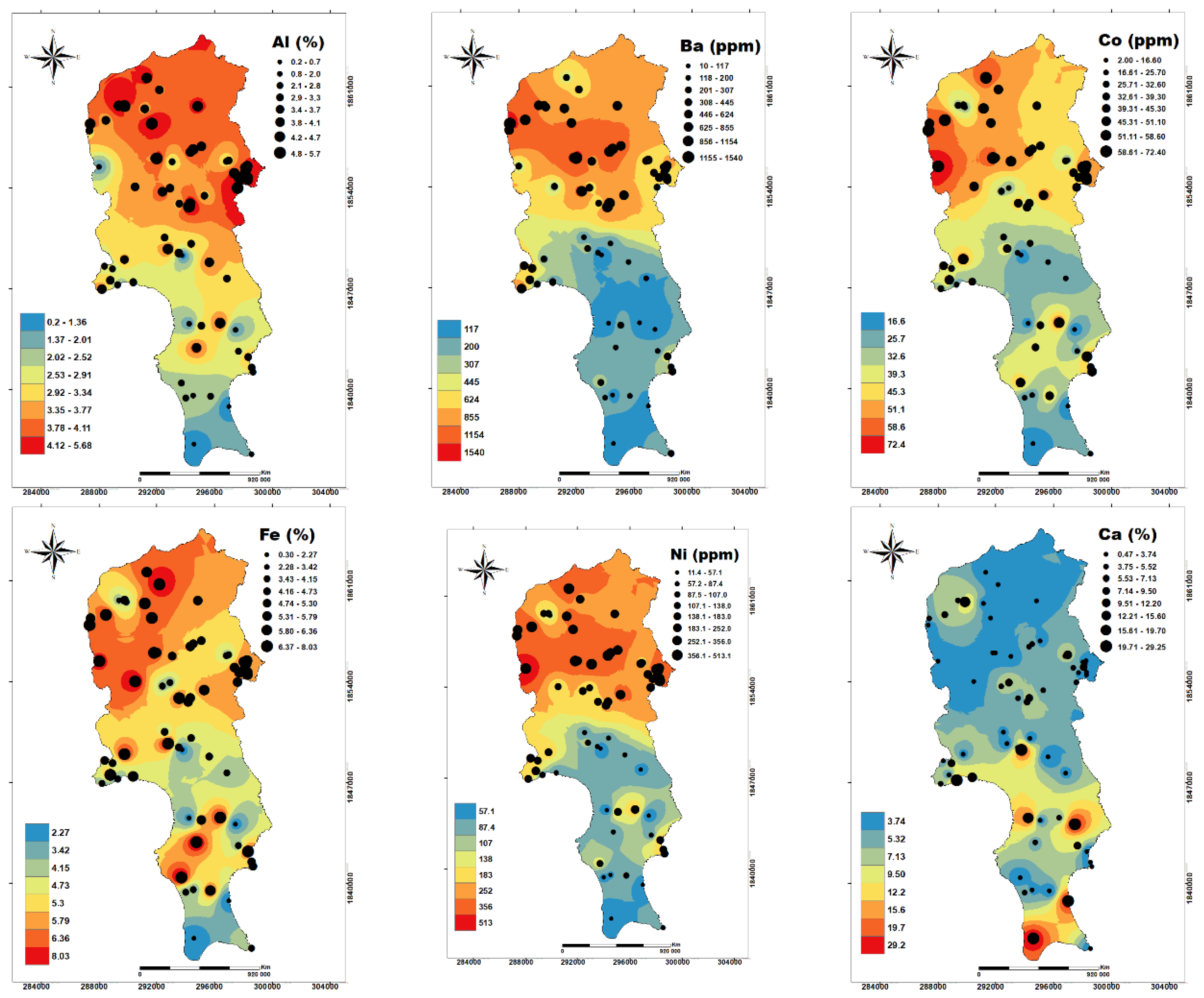
According to Table 2 and Table 3, the soils of Sal Island have contents of Ba, Co, Ni, and V above the cited legislation. Figure 2 shows that Ba, Co, and Ni have the highest contents in soils from the northern region of the island (Figure 3).
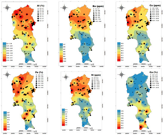
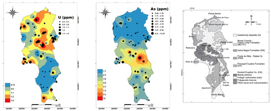
Figure 2.
Spatial distribution of the studied elements. Coordinate system: UTM zone 27p. The geological map of Figure 1 is shown in the last panel for easier comparison with the chemical element spatial fields.

Figure 3.
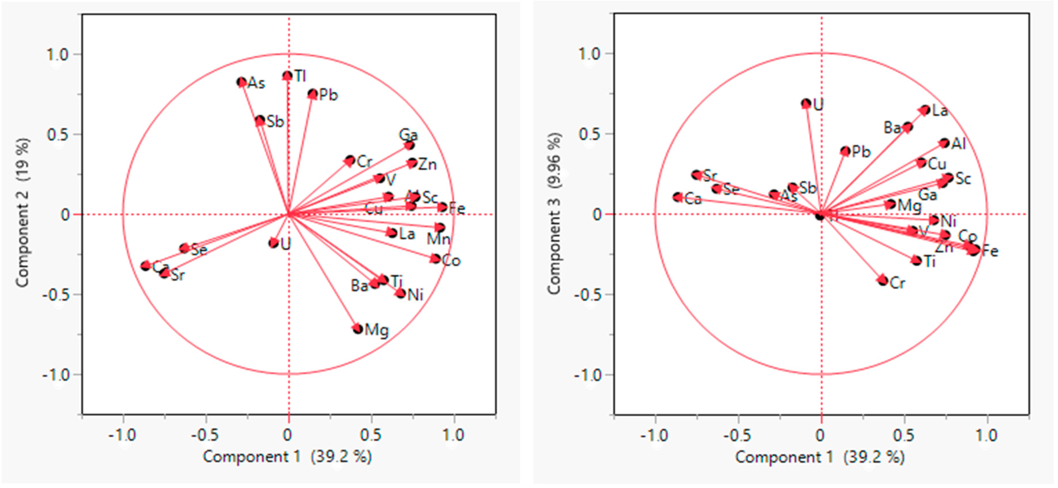
Biplot with the representation of variables in the two principal components (PC1 and PC2) obtained with PCAs.
The comparison of the spatial distribution of the studied chemical elements with the geological map suggests that the concentrations of the elements are controlled by the geological and geomorphological features of the island (Figure 2, Figure 3 and Figure 4).
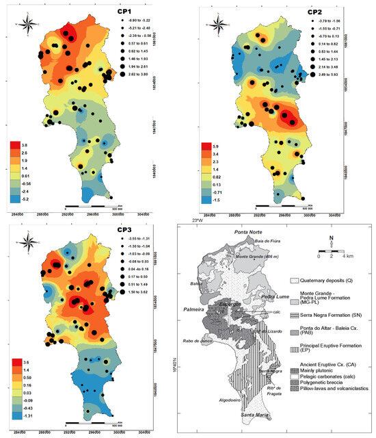
Figure 4.
Spatial distribution of PC1 and PC2. The geological map of Figure 1 is shown in the last panel for easier comparison with the PC spatial fields.
Figure 3 shows that the elements hosted by silicate minerals that are abundant in basaltic rocks (e.g., Al, Fe, Co, Mg, Ni, and Sc) have the highest concentrations in soils from northern island sectors. The grades of Ca, Sr, and Se appear to be particularly high in soils associated with sedimentary rocks from southern coastal regions, while U and La are more abundant in soils covering sedimentary units from the northern portion of the island. The highest concentrations of As, Pb, and Sb occur in a central strip, WNW–ESE-oriented, that cuts the area of the airport and the island’s capital, Espargos.
4.2. Multivariate Statistical Analysis
In order to confirm the links between the chemical elements and the mapped geological unit, a correlation-based PCA was also conducted. Using the scree graph, it was decided to retain three components, accounting for 68% of the total variance. Table 4 shows the loading matrix of the chemical elements in these components.
Table 4.
Loading of matrix values, highlighting those less or higher than −0.5 (highlighted by yellow) and 0.5 (highlighted by green), respectively.
Based on the biplots shown in Figure 3, the elements can be assembled as follows in the three main components (from CP1 to CP3):
- -
- CP1 explains 39% of the total variance. Elements that tend to be abundant in silicate rocks, such as Fe, Mn, Co, Sc, Zn, Al, Ni, La, V, and Ti, are plotted in opposition to Ca and Sr, typical of carbonate rocks. This suggests that CP1 reflects the silicate versus carbonate natures of soil parent rocks.
- -
- CP2 explains 19% of the total variance and positively associates Tl, As, Pb, and Sb, possibly reflecting the presence of anthropogenic sources. However, because these elements are frequently associated with saline environments, which are common on the island, they can also be considered to have a geogenic origin linked to the presence of evaporites.
- -
- CP3 explains 10% of the total variance, yielding relatively high loadings of U, La, and Ba. As these elements tend to be more abundant in phonolites and other feldspathoid-rich rocks than in basalts, it is probable that this reflects the nature of the most common lithological suites (basaltic vs. nephelinic) observed in the volcanic units of Sal Island.
Figure 4 shows the mapping of sample scores on the main axes from CP1 to CP3. The highest scores of PC1 are observed in a northern region of the island, in soils covering both mainly volcanic units (Monte Grande-Pedra Lume Formation and Ponta do Altar-Baleia Complex) and Quaternary sediments that stand on volcanic units. Soils covering the Ancient Eruptive Complex and the Principal Eruptive Formation yield lower PC1 scores but are still higher than those observed in those associated with sedimentary units from the southern realms of Sal Island.
The hypothesis of CP2 being partially associated with evaporitic environments is not supported by its distribution map, as low values are found in the region with the widest saline lake. The relatively high scores in samples collected near the airport and Espargos and in a strip extending to the east of that area could reinforce the possible association with human activities. Soil sampling sites at Sal were chosen in order to avoid contamination from human activities, but wind transport may account for the presence of a non-natural component. However, the orientation of the strip with higher PC2 values relative to the major locus of possible contamination (airport and Espargos) is not compatible with the prevailing regional winds (from NE). As the highest values are clustered in a core region of the island where the Ancient Eruptive Complex and the Principal Eruptive Formation are exposed, it can be assumed that the main sources of As, Pb, and Sb must be geogenic and related to these geological units.
Regarding PC3, the lowest values are observed in soils covering the mainly volcanic units associated with the long eruptive phase responsible for the building and emergence of Sal Island (Principal Eruptive Fm. and Ponta do Altar-Baleia Cx.). This distribution suggests that, overall, the basaltic component in these units is higher than in other eruptive units.
4.3. Ecologic Risks
Numerous indices were used to assess geochemical compositions. The calculation of these indices requires measurements in pristine medium for the elements under analysis, the so-called geochemical background [27,28,29,30,31,32]. Normalizing the PTE to the upper continental crust values was recommended by Håkanson [33]. However, as in the studied environment, we cropped out units associated with the oceanic crust, so we opted to do a normalization with the median values of all areas.
Contamination factors (CFis) were used to determine the potential ecological risk index (PERI). For each potentially harmful element, CFi was calculated with the following formula:
where C is the element (i) concentration.
CFi = Csample/Median,
The potential ecological risk index (PERI) was first introduced by Håkanson [33]. The index assesses the degree of elemental contamination in response to elements’ toxic effects or risks to the environment [34,35]. It is obtained by the following equations:
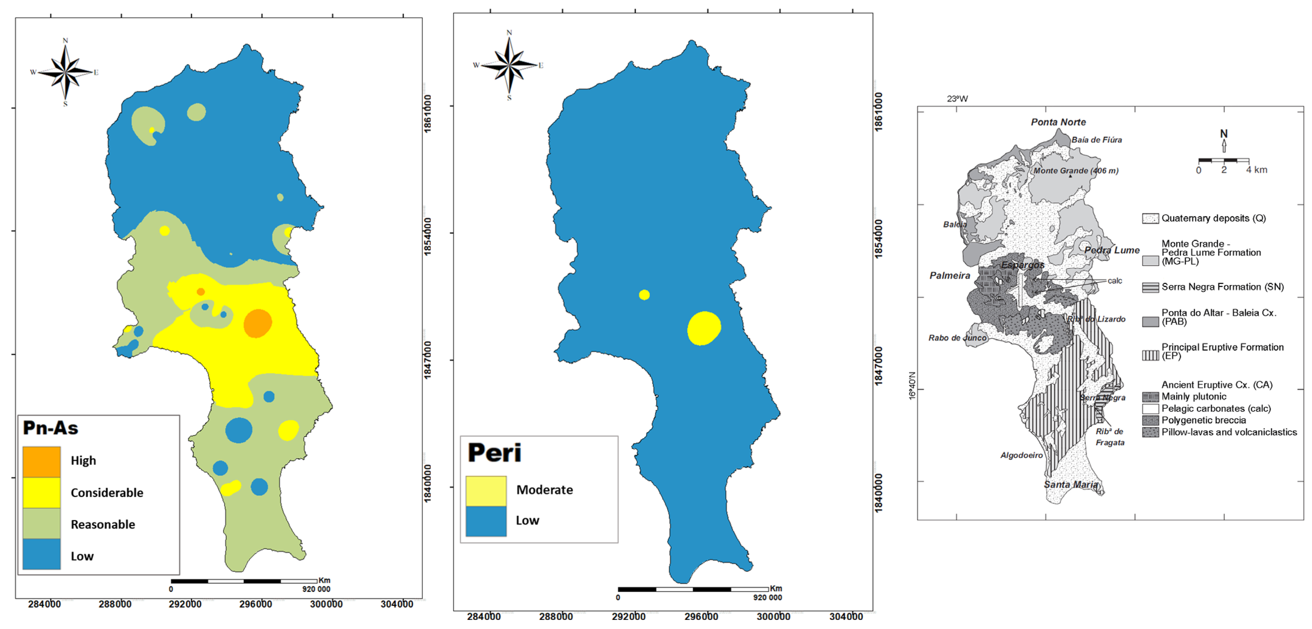
where Pn represents the potential ecological risk factor of individual PTE, which can be evaluated using Tn (toxic response factor), which expresses the toxic response of individual metal(loid)s, and CFi. The standardized value of Tn for As is 30 [33,36].
The concentration of As in soils constitutes considerable or high potential ecological risks (Figure 5). The other studied elements do not constitute ecological risks. Ecological risk assessment is expressed as the potential ecological risk index (PERI) and combines the single index of ecological risk factor (Pn) and the toxic response factor of an individual metal Tn, whereas PERI is expressed as the sum of potential risks of individual metals Pn that is calculated by multiplying the toxic-response factor of Tn by contamination factor (CF). Pn is classified as follows: Pn < 40 for low potential ecological risk; 40 ≤ Pn < 80 for reasonable ecological risk; 80 < Pn < 160 for considerable ecological risk; 160 ≤ Pn < 320 for high ecological risk; and Pn ≥ 320 for very high ecological risk. PERI is classified as follows: PERI < 95 for low potential ecological risk; 95 ≤ PERI < 190 for moderate ecological risk; 190 ≤ PERI < 380 for considerable ecological risk; and PERI ≥ 380 for high ecological risk. PERI gives the cumulative effect of all metals, which has a single index of ecological risk factor (Pn) higher than 40.

Figure 5.
Potential ecological risk factors and PERI determined for As values determined with soils from Sal Island. A geological map is present for better comparison.
The index PERI caused by the contents of As in soils reaches moderate ecological risk (190 ≤ PERI < 380) and is again in the area close to the airport, but also overlying Q and CEA. It is important to confirm the specific geogenic sources and possible anthropogenic contributions of As.
4.4. Estimation of Health Hazards Due to PTE Exposure
4.4.1. Non-Carcinogenic Risk
The human health risk caused by trace element exposure is expressed as the hazard quotient (HQ) = ADD/RfD. ADD is the average daily dose that a child or adult is exposed to. RfD is the reference dose, which is the daily dosage that enables the exposed individual to sustain no risk. The oral RfDs for As, Co, Cr, Pb, Cu, Ni, V, Mn, and Zn are 0.0003, 0.0003, 0.003, 0.0035, 0.04, 0.02, 0.00504, 0.024, and 0.3, respectively. The inhalation RfDs for As, Co, Cr, Pb, Cu, Ni, V, Mn, and Zn are 0.000015, 0.000006, 0.0001, 0.0035, 0.01, 0.00009, 0.0001, 0.00005, and 0.06, respectively. The dermal RfDs for As, Co, Cr, Pb, Cu, Ni, V, Mn, and Zn are 0.0003, 0.0003, 0.003, 0.0035, 0.04, 0.02, 0.00504, 0.024, and 0.3, respectively. Exposure to potential toxic elements (As, Co, Cr, Pb, Cu, Ni, V, Mn, and Zn) through these three pathways (i.e., ingestion, inhalation, and dermal contact) by two population sub-groups (adults and children) was calculated using Equations (4)–(6) described in USEPA [37,38,39].
where ADDing, ADDinh, and ADDderm are the average daily dose obtained through oral ingestion (mg/kg-day), inhalation of fugitive dust (mg/kg-day), and dermal contact (mg/kg-day). Cs is the concentration of PTEs (mg/kg); IngR is the ingestion rate (mg/day); EF is the exposure frequency (days/year); ED is the exposure duration (year); BW is the body weight (kg); AT is the averaging time (year); InhR is the inhalation rate (m3/h); ET is the exposure time (h/day); PEF is the soil-to-air particulate emission factor (kg/m3); SA is the skin surface area available for exposure (cm2); AF is the soil-to-skin adherence factor (mg/cm2-day); and ABS is the dermal absorption factor (unitless). PEF is the particle emission factor, i.e., 1.36 × 10⁹ m3/kg (USEPA) [32].
The non-carcinogenic risks of PTEs were characterized by a unitless hazard quotient (HQ) using Equations (7)–(9).
where HQing, HQinh, and HQderm are the hazard quotients from ingestion, inhalation, and dermal exposure. RfDing, RfDinh, and RfDderm are the reference doses of specific elements from ingestion, inhalation, and dermal exposures [40,41,42,43]. Hazard index (HI), which is an indicator of cumulative non-cancer health risk, was calculated by summing HQs from all three exposure pathways. The HI value less than 1 is assumed to be safe for human health, while the HI value greater than 1 may pose adverse non-carcinogenic health consequences.
The concentrations of several elements in the studied soil may represent a health risk for humans (Figure 6). The danger values of HI were found only for children.
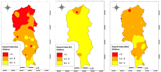
Figure 6.
Hazard index for non-carcinogenic risk associated with As, Cr, and Mn, and V for children.
Significant risks were also found for exposure to cobalt in soils. The highest value of Co in soil reaches HI = 3, covering mainly Mg-PL, Q, and P-AB in the north of the island mainly. The highest value of Cr in soil reaches HI = 3 in soil overlying Q, Mg-PL, P-AB, and EP deposits. The highest value for Mn is HI = 2, and it occurs in soil covering almost all of the island, with the highest HI in soils in northern Sal.
4.4.2. Carcinogenic Risks
Carcinogenic risks of As through ingestion, inhalation, and dermal pathways were calculated using Equations (10)–(12).
where ILCRing, ILCRinh, and ILCRderm are the incremental lifetime cancer risk through ingestion, inhalation, and dermal pathways, respectively (unitless). CSFing, CSFinh, and CSFderm are the cancer slope factors through ingestion, inhalation, and dermal contact, respectively ([mg/kg-day]−1). The CSF values of As for ingestion, inhalation, and dermal contacts are 1.5, 15.1, and 3.66, respectively [40,41]. Total incremental lifetime cancer risk (TILCR) was calculated by summing the ILCR of As from ingestion, inhalation, and dermal pathways. The TILCR exceeding the value of 1 × 10⁻⁶ is typically considered unacceptable, with potential carcinogenic health consequences for the exposed population (USEPA) [42,43]. The concentrations detected in the soil do not suggest a carcinogenic risk associated with As.
The only element that occurs in soil in sufficiently high concentrations that can increase cancer risk is Cr [44]. Hazardous exposure can be considered for adults (Table 5). As with non-carcinogenic risk, the regions that deserve more concern are in the northern portion of the island.
Table 5.
Carcinogenic risk associated with Cr.
5. Conclusions
Sal Island (Cape Verde) was generated through a series of volcanic eruptions. Sedimentary units record periods of volcanic quiescence, when the eruptive buildings suffered weathering and erosion. Some soils associated with these magmatic and sedimentary units yield high grades of elements that can be hazardous for the environment and human health. Soil composition reveals diverse spatial trends that can be linked to the mainly basaltic vs. nephelinic character of local volcanic units, the carbonate/evaporitic vs. siliciclastic nature of sedimentary units, and the proximity to diverse intrusive units in the core of the island.
In the soils of Sal Island, concentrations of Ba, Co, Ni, and V can be above the admissible levels according to the Ontario and Duch guidelines. The occurrence of Co, Ni, and V siderophile elements is usually high in basaltic rocks, while Ba must be mainly sourced from nephelinic rocks. Out of all the analyzed elements, in an area with exposures of the Ancient Eruptive Complex, the Principal Eruptive Formation, and sedimentary deposits covering these units, As is the element that potentially poses the highest ecological risks. Regarding human health, a hazard index was found in soils (>1) with high contents of Cr (particularly in the northern realms of Sal with volcanic units), Co (locally high in soils associated with basaltic rocks), and Mn (only low in regions with extensive exposures to sedimentary units) for children. High concentrations of Cr in soils raise cancer risk in adults at a few sites. It is important to highlight that the health risk associated with exposure is the maximum possible, as instead of physiological fluids, aqua regia was used to digest the soils, which is likely to overestimate the bioavailable fractions.
However, because measured levels of potential toxic elements in soil can be harmful to both the environment and human health, competent authorities must be alerted to control regional activities such as agriculture and water exploitation. These conclusions highlight the insights and the applicability of surveys about soil geochemistry for future policy development, which are particularly relevant in developing countries like Sal Island.
Author Contributions
Conceptualization, M.C.P. and L.D.; methodology, L.D., G.C., C.M., P.D., R.M., F.T.R., E.F.d.S., A.A. and M.C.P.; software, G.C., P.D. and M.C.P.; validation, L.D., A.A., E.F.d.S. and M.C.P.; formal analysis, L.D., G.C. and C.M.; investigation, L.D., G.C., C.M. and M.C.P.; resources, F.T.R.; data curation, L.D., G.C., P.D. and M.C.P.; writing—original draft preparation, L.D., G.C., P.D. and M.C.P.; writing—review and editing, M.C.P., G.C. and P.D.; visualization, G.C.; supervision, E.F.d.S., A.A. and M.C.P.; project administration, M.C.P.; funding acquisition, M.C.P. All authors have read and agreed to the published version of the manuscript.
Funding
Geobiotec (UIDB/04035/2020—GeoBioTec-GeoBioSciences, GeoTechnologies and GeoEngineering).
Data Availability Statement
The raw data supporting the conclusions of this article will be made available by the authors on request.
Acknowledgments
The authors thank the three reviewers, which helped to improve the manuscript, and also to João Duarte for its constant disponibility.
Conflicts of Interest
The authors declare no conflict of interest.
References
- Steffen, W.; Grinevald, J.; Crutzen, P.; McNeill, J. The Anthropocene: Conceptual and historical perspectives. Philos. Trans. R. Soc. A Math. Phys. Eng. Sci. 2011, 369, 842–867. [Google Scholar] [CrossRef]
- Lewis, S.L.; Maslin, M.A. Defining the anthropocene. Nature 2015, 519, 171–180. [Google Scholar] [CrossRef]
- Salminen, R.; Chekushin, V.; Tenhola, M.; Gregorauskiene, V.; Bogatyrev, I.; Kashulina, G.; Fedotova, E.; Niskavaara, H.; Polischuok, A.; Glavatskikh, S.P.; et al. Geochemical Atlas of Eastern Barents Region; Gulf Professional Publishing: Houston, TX, USA, 2005. [Google Scholar]
- De Vivo, B.; Lima, A.; Bove, M.A.; Albanese, S.; Cicchella, D.; Sabatini, G.; Di Lella, L.A.; Protano, G.; Riccobono, F.; Frizzo, P.; et al. Environmental geochemical maps of Italy from the FOREGS database. Geochem. Explor. Environ. Anal. 2008, 8, 267–277. [Google Scholar] [CrossRef]
- Halamić, J.; Peh, Z.; Miko, S.; Galović, L.; Šorša, A. Geochemical atlas of Croatia: Environmental implications and geodynamical thread. J. Geochem. Explor. 2012, 115, 36–46. [Google Scholar] [CrossRef]
- Bravo, S.; García-Ordiales, E.; García-Navarro, F.J.; Amorós, J.Á.; Pérez-de-Los-Reyes, C.; Jiménez-Ballesta, R.; Esbrí, J.M.; García-Noguero, E.M.; Higueras, P. Geochemical distribution of major and trace elements in agricultural soils of Castilla-La Mancha (central Spain): Finding criteria for baselines and delimiting regional anomalies. Environ. Sci. Pollut. Res. 2019, 26, 3100–3114. [Google Scholar] [CrossRef]
- Cinelli, G.; Tollefsen, T.; Bossew, P.; Gruber, V.; Bogucarskis, K.; De Felice, L.; De Cort, M. Digital version of the European Atlas of natural radiation. J. Environ. Radioact. 2019, 196, 240–252. [Google Scholar] [CrossRef] [PubMed]
- De Caritat, P.; Cooper, M. A Continental-Scale Geochemical Atlas for Resource Exploration and Environmental Management: The National Geochemical Survey of Australia; The Geological Society of London: London, UK, 2016. [Google Scholar]
- Musgrove, M. The occurrence and distribution of strontium in US groundwater. Appl. Geochem. 2021, 126, 104867. [Google Scholar] [CrossRef]
- Smith, D.B.; Wang, X.; Reeder, S.; Demetriades, A. The IUGS/IAGC task group on global geochemical baselines. Earth Sci. Front. 2012, 19, 1–6. [Google Scholar]
- Zuzolo, D.; Cicchella, D.; Demetriades, A.; Birke, M.; Albanese, S.; Dinelli, E.; Lima, A.; Valera, P.; De Vivo, B. Arsenic: Geochemical distribution and age-related health risk in Italy. Environ. Res. 2020, 182, 109076. [Google Scholar] [CrossRef] [PubMed]
- Cabral Pinto, M.M.; Marinho-Reis, A.P.; Almeida, A.; Ordens, C.M.; Silva, M.M.; Freitas, S.; Simões, M.R.; Moreira, P.I.; Dinis, P.A.; Diniz, M.L.; et al. Human predisposition to cognitive impairment and its relation with environmental exposure to potentially toxic elements. Environ. Geochem. Health 2018, 40, 1767–1784. [Google Scholar] [CrossRef] [PubMed]
- Cabral Pinto, M.M.; Ordens, C.M.; Condesso de Melo, M.T.; Inácio, M.; Almeida, A.; Pinto, E.; Ferreira da Silva, E.A. An inter-disciplinary approach to evaluate human health risks due to long-term exposure to contaminated groundwater near a chemical complex. Expo. Health 2020, 12, 199–214. [Google Scholar] [CrossRef]
- Cabral-Pinto, M.M.; Saha, N.; Ordens, C.M.; Pitta-Gros, D.; Carlos, G.; Dinis, P.; Marques, R.; Prudêncio, I.; Rocha, F.; Ferreira da Silva, E.A. Integrated Geochemical and Mineralogical Investigation of Soil from the Volcanic Fogo Island (Cape Verde): Implications for Ecological and Probabilistic Human Health Risks. Expo. Health 2023, 15, 1–17. [Google Scholar] [CrossRef]
- Darnley, A.G.; Bjorklund, A.; Bolviken, B.; Gustavsson, N.; Koval, P.V.; Uk, J.P.; Steenfelt, A.; Tauchid, M.; Xuejing, X. A Global Geochemical Database. Recommendations for International Geochemical Mapping; Final Report of IGCP Project; UNESCO Publishing: Paris, France, 1995; Volume 259. [Google Scholar]
- Diniz, A.C.; de Matos, G.C. Map of Agro-Ecological Zonation and Vegetation in Cape Verde; V-Sal Island: Sal, Cape Verde, 1993. [Google Scholar]
- Lee, D.B.; Kim, Y.N.; Sonn, Y.K.; Kim, K.H. Comparison of Soil Taxonomy (2022) and WRB (2022) Systems for classifying Paddy Soils with different drainage grades in South Korea. Land 2023, 12, 1204. [Google Scholar] [CrossRef]
- Holm, P.; Wilson, J.R.; Christensen, B.; Hansen, L.; Hansen, S.; Khein, K.M.; Mortensen, A.; Pedersen, R.; Plesner, S.; Runge, M. Sampling the Cape Verde Plume: Evolution of Melt Compositions on Santo Antão, Cape Verde Islands. J. Petrol. 2008, 47, 145–189. [Google Scholar] [CrossRef]
- Ramalho, R.S.; Helffrich, G.; Cosca, M.; Vance, D.; Hoffmann, D.; Schmidt, D.N. Vertical movements of ocean island volcanoes: Insights from a stationary plate environment. Mar. Geol. 2010, 275, 84–95. [Google Scholar] [CrossRef]
- Ubaldo, M.L.; Silva, L.C.; Torres, P.C. Geological and Micropaleontological Contribution towards the Knowledge of the “Old Eruptive Complex” of Sal Island, Cape Verde Archipelago. 1991. Available online: https://www.researchgate.net/figure/Geological-map-of-Sal-Island-showing-the-stratigraphic-units-after-TORRES-et-al_fig3_215579234 (accessed on 30 May 2024).
- Torres, P.; Silva, L.; Serralheiro, A.; Mendes, M.; Macedo, J.; Gomes, A. Geologia da Ilha do Sal, Comunicações do Instituto de Investigação Científica Tropical. 2002. Available online: https://repositorio.usp.br/directbitstream/324f83bd-aad7-4130-831b-2f5bf3b13db2/2433496.pdf (accessed on 30 May 2024).
- Torres, P.; Silva, L.D.; Munhá, J.; Caldeira, R.; Mata, J.; Tassinari, C.C.G. Petrology and geochemistry of lavas from Sal Island: Implications for the variability of the Cape Verde magmatism. Comun. Geol. 2010, 97, 35–61. [Google Scholar]
- Zazo, C.; Goy, J.; Dabrio, C.; Soler, V.; Hillaire-Marcel, C.; Ghaleb, B.; González-Delgado, J.; Bardají, T.; Cabero, A. Quaternary marine terraces on Sal Island (Cape Verde archipelago). Quat. Sci. Rev. 2007, 26, 876–893. [Google Scholar] [CrossRef]
- Jolliffe, I.T. Principal Component Analysis for Special Types of Data; Springer: New York, NY, USA, 2003; pp. 338–372. [Google Scholar]
- Canadian Legislation: Ministry of the Environment April 15, 2011. Soil, Ground Water and Sediment Standards for Use under Part XV.1 of the Environmental Protection Act. Available online: https://www.ontario.ca/page/soil-ground-water-and-sediment-standards-use-under-part-xv1-environmental-protection-act (accessed on 30 May 2024).
- Dutch Guidelines: Ministry of Housing, Spatial Planning and the Environment (VROM). Circular on Target Values and Intervention Values for Soil Remediation. The Netherlands Government Gazette, No. 39, Ministry of Housing, Spatial Planning and Environment, Directorate General for Environmental Protection, Department of Soil Protection. Available online: http://www.esdat.net/Environmental%20Standards/Dutch/annexS_I2000Dutch%20Environmental%20Standards.pdf (accessed on 30 May 2024).
- Ji, J.; Zhao, Y.; Zhang, W.; Gu, K.; Li, W. Quantitative assessment of biocrust distribution patterns using landscape indices benefits the study of their soil conservation functions. Geoderma 2023, 429, 116257. [Google Scholar] [CrossRef]
- Cabral Pinto, M.M.; Ferreira da Silva, E.A.; Silva, M.M.; Melo-Gonçalves, P.; Candeias, C. Environmental risk assessment based on high-resolution spatial maps of potentially toxic elements sampled on soil of Santiago, Cape Verde. Geosciences 2014, 4, 297–315. [Google Scholar] [CrossRef]
- Cabral-Pinto, M.M.S.; Silva, E.F.; Silva, M.M.V.G.; Melo-Gonçalves, P. Heavy metals of Santiago Island (Cape Verde) top soils: Estimated background value maps and environmental risk assessment. J. Afr. Earth Sci. 2015, 101, 162–176. [Google Scholar] [CrossRef]
- Cabral Pinto, M.M.; Silva, M.M.; Ferreira da Silva, E.A.; Marinho-Reis, A.P. The cancer and non-cancer risk of Santiago Island (Cape Verde) population due to potential toxic elements exposure from soils. Geosciences 2017, 7, 78. [Google Scholar] [CrossRef]
- Cabral Pinto, M.M.; Marinho-Reis, P.; Almeida, A.; Pinto, E.; Neves, O.; Inácio, M.; Gerardo, B.; Freitas, S.; Simões, M.R.; Dinis, P.A.; et al. Links between cognitive status and trace element levels in hair for an environmentally exposed population: A case study in the surroundings of the estarreja industrial area. Int. J. Environ. Res. Public Health 2019, 16, 4560. [Google Scholar] [CrossRef] [PubMed]
- Nayeri, S.; Dehghanian, Z.; Lajayer, B.A.; Thomson, A.; Astatkie, T.; Price, G.W. CRISPR/Cas9-Mediated genetically edited ornamental and aromatic plants: A promising technology in phytoremediation of heavy metals. J. Clean. Prod. 2023, 428, 139512. [Google Scholar] [CrossRef]
- Håkanson, L. An ecological risk index for aquatic pollution control. A sedimentological approach. Water Res. 1980, 14, 975–1001. [Google Scholar] [CrossRef]
- Maanan, M.; Saddik, M.; Maanan, M.; Chaibi, M.; Assobhei, O.; Zourarah, B. Environmental and ecological risk assessment of heavy metals in soil of Nador lagoon, Morocco. Ecol. Indic. 2015, 48, 616–626. [Google Scholar] [CrossRef]
- Kumar, A.; Suryadevara, N.; Hill, T.M.; Bezbradica, J.S.; Van Kaer, L.; Joyce, S. Natural killer T cells: An ecological evolutionary developmental biology perspective. Front. Immunol. 2017, 8, 1858. [Google Scholar] [CrossRef]
- Doležalová Weissmannová, H.; Mihočová, S.; Chovanec, P.; Pavlovský, J. Potential ecological risk and human health risk assessment of heavy metal pollution in industrial affected soils by coal mining and metallurgy in Ostrava, Czech Republic. Int. J. Environ. Res. Public Health 2019, 16, 4495. [Google Scholar] [CrossRef]
- USEPA (United States Environmental Protection Agency). Calculating Upper Confidence Limits for Exposure Point Concentrations at Hazardous Waste Sites; Office of Emergency and Remedial Response: Washington, DC, USA, 2002.
- USEPA (United States Environmental Protection Agency). Risk Assessment Guidance for Superfund: Volume III—Part A, Process for Conducting Probabilistic Risk Assessment; EPA 540-R-02-002; U.S. Environmental Protection Agency: Washington, DC, USA, 2001.
- USEPA (United States Environmental Protection Agency). Science Policy Council. Guidance on Cumulative Risk Assessment. Part 1; U.S. Environmental Protection Agency: Washington, DC, USA, 2001.
- De Miguel, E.; Iribarren, I.; Chacon, E.; Ordonez, A.; Charlesworth, S. Risk-based evaluation of the exposure of children to trace elements in playgrounds in Madrid (Spain). Chemosphere 2007, 66, 505–513. [Google Scholar] [CrossRef]
- Chabukdhara, M.; Nema, A.K. Heavy metals assessment in urban soil around industrial clusters in Ghaziabad, India: Probabilistic health risk approach. Ecotoxicol. Environ. Saf. 2013, 87, 57–64. [Google Scholar] [CrossRef]
- USEPA (United States Environmental Protection Agency). Toxicological Review of Inorganic Arsenic; U.S. Environmental Protection Agency: Washington, DC, USA, 2010.
- USEPA (United States Environmental Protection Agency). Exposure Factors Handbook 2011 Edition (Final). 2011. Available online: http://cfpub.epa.gov/ncea/risk/recordisplay.cfm?deid=236252 (accessed on 30 May 2024).
- IARC (International Agency for Research on Cancer). Chromium, Nickel and Welding. In Monographs on the Evaluation of Carcinogenic Risks to Humans; IARC: Lyon, France, 1990; Volume 49. [Google Scholar]


Disclaimer/Publisher’s Note: The statements, opinions and data contained in all publications are solely those of the individual author(s) and contributor(s) and not of MDPI and/or the editor(s). MDPI and/or the editor(s) disclaim responsibility for any injury to people or property resulting from any ideas, methods, instructions or products referred to in the content. |
© 2024 by the authors. Licensee MDPI, Basel, Switzerland. This article is an open access article distributed under the terms and conditions of the Creative Commons Attribution (CC BY) license (https://creativecommons.org/licenses/by/4.0/).