From Expansion to Shrinkage: An Assessment of the Carbon Effect from Spatial Reconfiguration of Rural Human Settlements in the Wuhan Metropolitan Area
Abstract
:1. Introduction
- Quantitatively analyze the spatial pattern of rural construction land transfers to comprehensively reflect the evolutionary stages.
- Assess the impacts of spatial and temporal changes in rural built-up land on regional carbon stocks over time.
- Forecast the spatial distribution of carbon stock in the Wuhan Metropolitan Area by 2030 under different scenarios of rural built-up land expansion and shrinkage.
2. Materials and Methods
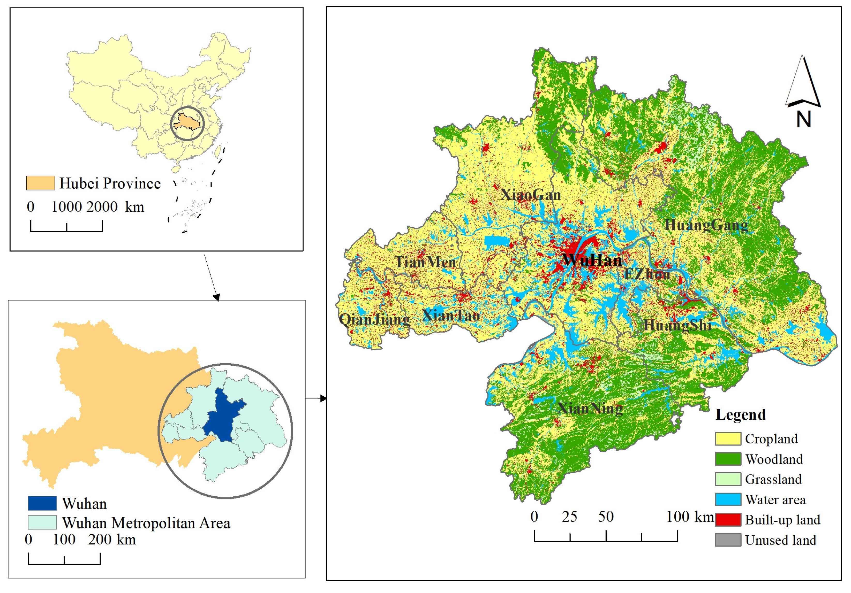
2.1. Study Area
2.2. Data Acquisition and Processing
2.2.1. Urban Built-up Land and Rural Built-up Land Classification System
2.2.2. Data Sources
2.3. Research Methods
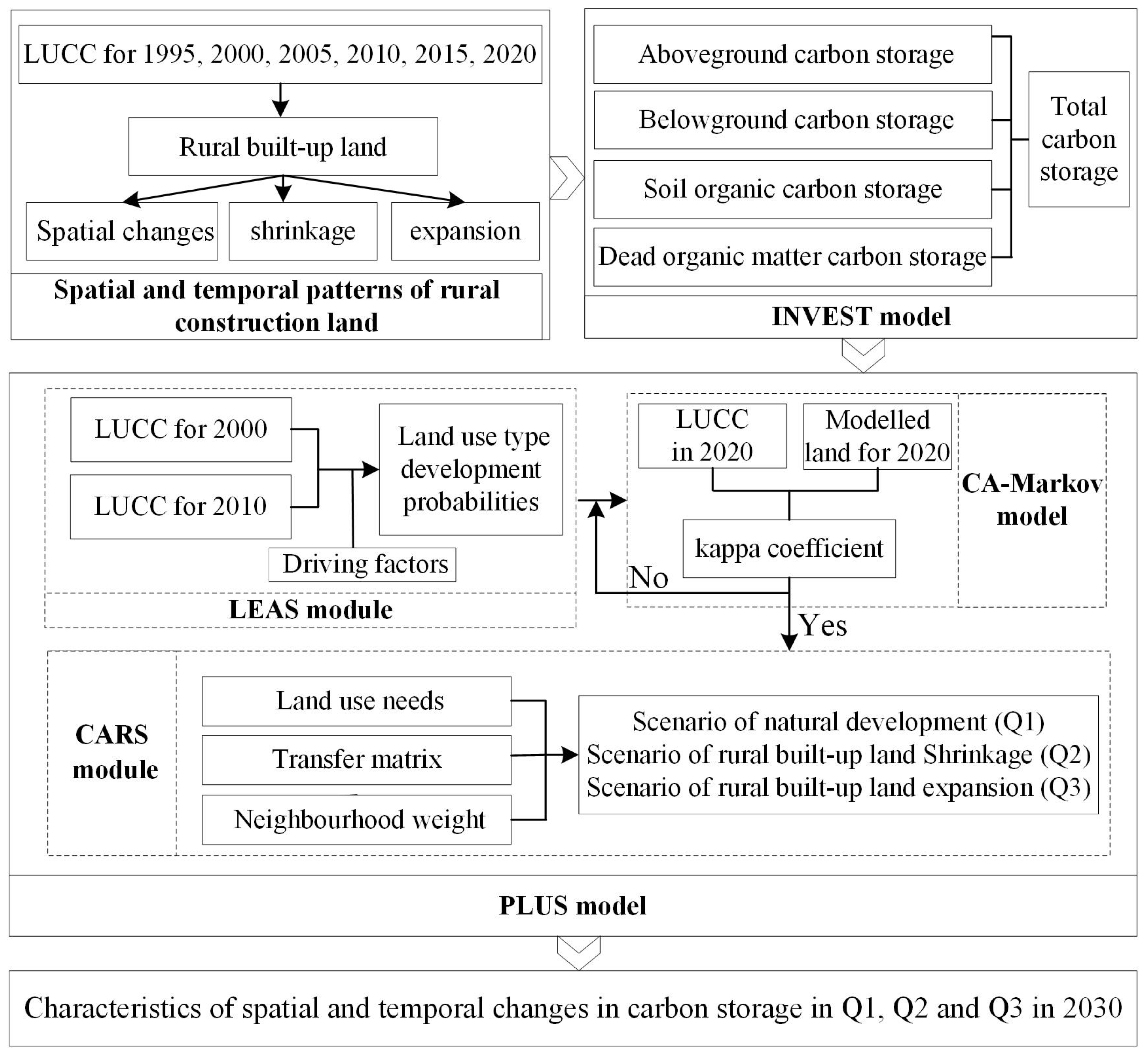
2.3.1. The Research Framework
2.3.2. InVEST Model
2.3.3. Markov Chain
2.3.4. PLUS Model
- (1)
- Accuracy verification
- (2)
- Multi-scenario settings
- (3)
- Weight setting.
3. Results and Analysis
3.1. Analysis of Spatial and Temporal Patterns of Rural Built-up Land
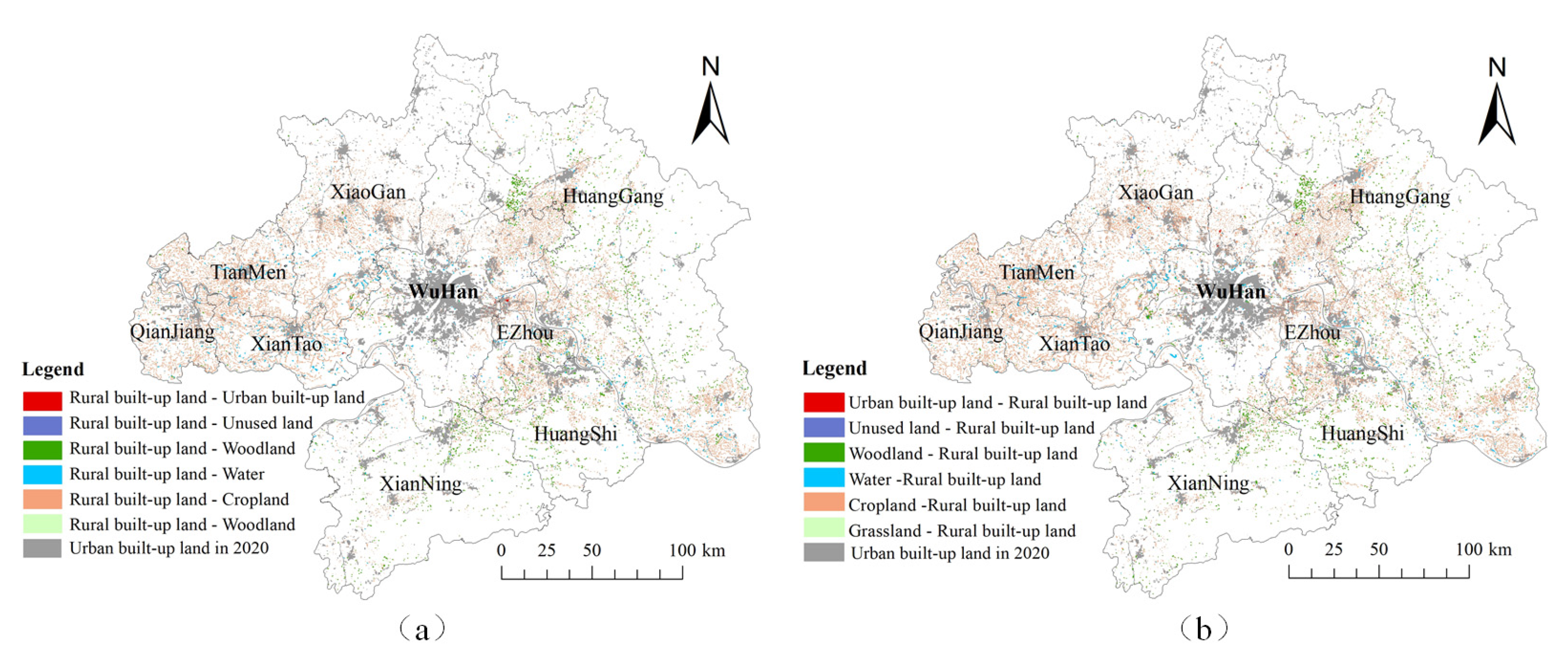
3.1.1. Analysis of the Overall Pattern of Rural Built-up Land
3.1.2. Analysis of the Temporal Pattern of Shrinkage of Rural Built-up Land
3.1.3. Analysis of the Temporal Pattern of Rural Built-up Land Expansion
3.2. Impact of Spatial Evolution of Rural Built-up on Carbon Storages
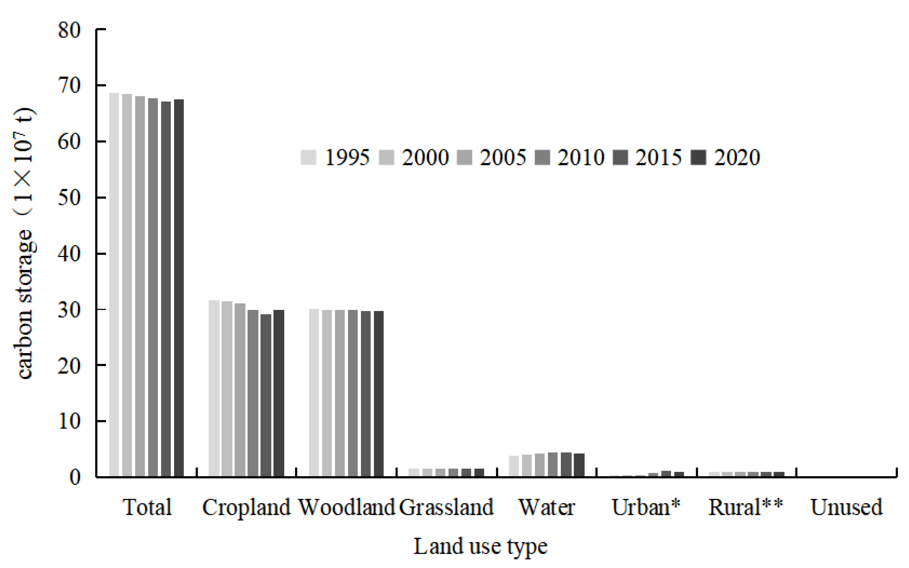
3.2.1. Value of Carbon Storage Changes Due to Overall Land-Use Change
3.2.2. Value of Changes in Carbon Storages Due to Shrinkage of Rural Built-up Land
3.2.3. Value of Carbon Storage Changes Due to Expansion of Rural Built-up Land
3.3. Land Use Modeling and Carbon Storage Projections under Different Scenarios for 2030
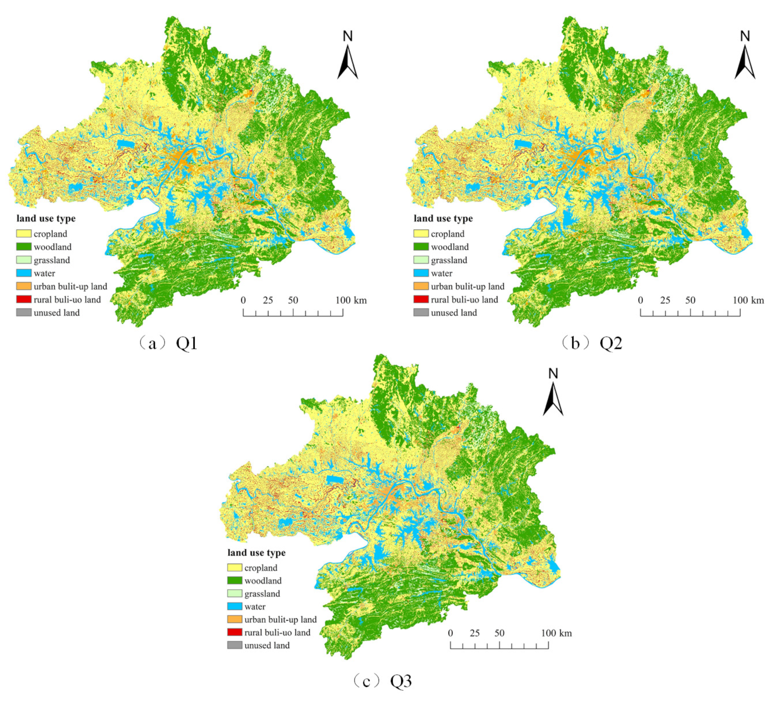
3.3.1. Simulation of Land-Use Change under Different Scenarios
3.3.2. Simulation of Carbon Storage Distribution under Different Scenarios
4. Discussion
4.1. Analysis of Factors Related to Changes in Land Use Types
4.2. Comparison with Existing Research
4.3. Policy Implications
- (1)
- In response to the ongoing increase of rural constructed land and its impact on ecosystem carbon storage, the government should improve rural built-up land transfer management, optimize the transfer mechanism, and encourage reasonable transfers to avoid land idleness and waste. Additionally, it should intensify ecological restoration activities in critical areas such as the Wu-E border, Tianmen, and southern Xiantao to enhance regional carbon storage capacity and promote the recovery and expansion of ecosystem carbon stocks.
- (2)
- The government should promote a shift in land-use planning to a “demand-oriented” approach. The actual needs and interests of farmers should be fully considered and respected in the planning process to ensure that planning programs are closely integrated with the production and life of farmers. By enhancing the flexibility and operability of planning, the planning objectives will be closer to the actual situation of farmers, thus improving the implementation and acceptance of planning and reducing negative impacts on regional carbon stocks.
- (3)
- To strengthen the management of carbon stock in land resources, the government should establish a carbon stock monitoring system to regularly assess and report changes in carbon stock. At the same time, it should implement differentiated carbon stock protection policies based on the geographical distribution characteristics of carbon stock changes. Through policy guidance and market mechanisms, the rational flow and optimal allocation of factors of production within the region should be promoted to achieve the harmonious unity of economic, social, and ecological benefits.
5. Conclusions
- (1)
- The area of rural built-up land generally increased between 1995 and 2020. However, unlike previous years, the area decreased in 2010. Compared to the expansion of rural built-up land, the shrinkage is more concentrated, primarily at the Wu-E border, Tianmen, and southern Xiantao. The carbon stock of terrestrial ecosystems in the Wuhan urban area showed a cyclical pattern of continuous decline followed by brief recovery.
- (2)
- According to the PLUS model’s prediction results, under the rural construction land expansion scenario, a significant amount of arable land is encroached upon. Additionally, most changes in rural built-up land occur around the original home base, forming a pattern of large-scale agglomeration and small-scale dislocation.
- (3)
- In the natural development scenario, the carbon storage value of land resources is 6753.62 × 105 tons. The total carbon storage under the rural built-up land shrinkage scenario surpasses that of the other two scenarios. Concurrently, the alteration in carbon storage across land resources exhibits a distinct geographical distribution pattern, characterized by a gradient radiating from the primary urban zone of Wuhan City and demonstrating disparate growth rates in various directions.
- (1)
- Monitoring changes in land cover status through high-resolution, multi-temporal remote sensing data, and establishing more accurate and comprehensive simulation and prediction models of land use changes.
- (2)
- Studying the changing patterns of rural built-up land to deeply explore and understand the phenomena of expansion and contraction in rural built-up land.
- (3)
- Combining remote sensing data with other data sources to assess the impact of these changes on functions such as the carbon cycle, biodiversity, and soil and water conservation.
Author Contributions
Funding
Institutional Review Board Statement
Informed Consent Statement
Data Availability Statement
Conflicts of Interest
References
- Abbass, K.; Qasim, M.Z.; Song, H. A review of the global climate change impacts, adaptation, and sustainable mitigation measures. Environ. Sci. Pollut. Res. 2022, 29, 42539–42559. [Google Scholar] [CrossRef] [PubMed]
- Matthews, H.D.; Gillett, N.P.; Stott, P.A.; Zickfeld, K. The proportionality of global warming to cumulative carbon emissions. Nature 2009, 459, 829–832. [Google Scholar] [CrossRef] [PubMed]
- Udara Willhelm Abeydeera, L.H.; Wadu Mesthrige, J.; Samarasinghalage, T.I. Global research on carbon emissions: A scientometric review. Sustainability 2019, 11, 3972. [Google Scholar] [CrossRef]
- Miles, L.; Kapos, V. Reducing greenhouse gas emissions from deforestation and forest degradation: Global land-use implications. Science 2008, 320, 1454–1455. [Google Scholar] [CrossRef] [PubMed]
- Jurjonas, M.; Seekamp, E. Balancing carbon dioxide: A case study of forest preservation, out-migration, and afforestation in the Pueblos Mancomunados of Oaxaca, Mexico. J. Sustain. For. 2019, 38, 697–714. [Google Scholar] [CrossRef]
- Ye, X.; Chuai, X. Have rural settlement changes harmed ecosystem carbon in China? Appl. Geogr. 2023, 153, 102917. [Google Scholar] [CrossRef]
- Vercher, N.; Bosworth, G.; Esparcia, J. Developing a framework for radical and incremental social innovation in rural areas. J. Rural Stud. 2023, 99, 233–242. [Google Scholar] [CrossRef]
- Jiang, C.; Li, J.; Liu, J. Does urbanization affect the gap between urban and rural areas? Evidence from China. Socio-Econ. Plan. Sci. 2022, 82, 101271. [Google Scholar] [CrossRef]
- Wang, Y.; Liu, Y.; Li, Y.; Li, T. The spatio-temporal patterns of urban–rural development transformation in China since 1990. Habitat Int. 2016, 53, 178–187. [Google Scholar] [CrossRef]
- Duan, Y.; Wang, H.; Huang, A.; Xu, Y.; Lu, L.; Ji, Z. Identification and spatial-temporal evolution of rural “production-living-ecological” space from the perspective of villagers’ behavior—A case study of Ertai Town, Zhangjiakou City. Land Use Policy 2021, 106, 105457. [Google Scholar] [CrossRef]
- Vermeulen, S.J.; Campbell, B.M.; Ingram, J.S. Climate change and food systems. Annu. Rev. Environ. Resour. 2012, 37, 195–222. [Google Scholar] [CrossRef]
- Han, D.; Qiao, J.; Zhu, Q. Rural-spatial restructuring promoted by land-use transitions: A case study of Zhulin Town in central China. Land 2021, 10, 234. [Google Scholar] [CrossRef]
- Van Vliet, J.; de Groot, H.L.; Rietveld, P.; Verburg, P.H. Manifestations and underlying drivers of agricultural land use change in Europe. Landsc. Urban Plan. 2015, 133, 24–36. [Google Scholar] [CrossRef]
- Cuadrado-Ciuraneta, S.; Durà-Guimerà, A.; Salvati, L. Not only tourism: Unravelling suburbanization, second-home expansion, and “rural” sprawl in Catalonia, Spain. Urban Geogr. 2017, 38, 66–89. [Google Scholar] [CrossRef]
- Tian, Y.; Qian, J.; Wang, L. Village classification in metropolitan suburbs from the perspective of urban-rural integration and improvement strategies: A case study of Wuhan, central China. Land Use Policy 2021, 111, 105748. [Google Scholar] [CrossRef]
- Wen, Q.; Li, J.; Ding, J.; Wang, J. Evolutionary process and mechanism of population hollowing out in rural villages in the farming-pastoral ecotone of Northern China: A case study of Yanchi County, Ningxia. Land Use Policy 2023, 125, 106506. [Google Scholar] [CrossRef]
- Rao, J. Comprehensive land consolidation as a development policy for rural vitalization: Rural In Situ Urbanisation through semi socio-economic restructuring in Huai Town. J. Rural Stud. 2022, 93, 386–397. [Google Scholar] [CrossRef]
- Chen, K.; Wang, Y.; Li, N.; Xu, Y.; Zheng, Y.; Zhan, X.; Li, Q. The impact of farmland use transition on rural livelihood transformation in China. Habitat Int. 2023, 135, 102784. [Google Scholar] [CrossRef]
- Zhang, X.; Brandt, M.; Tong, X.; Ciais, P.; Yue, Y.; Xiao, X.; Zhang, W.; Wang, K.; Fensholt, R. A large but transient carbon sink from urbanization and rural depopulation in China. Nat. Sustain. 2022, 5, 321–328. [Google Scholar] [CrossRef]
- Chen, Z.; Li, Y.; Liu, Y.; Liu, X. Does rural residential land expansion pattern lead to different impacts on eco-environment? A case study of loess hilly and gully region, China. Habitat Int. 2021, 117, 102436. [Google Scholar] [CrossRef]
- Li, P.; Chen, J.; Li, Y.; Wu, W. Using the InVEST-PLUS model to predict and analyze the pattern of ecosystem carbon storage in Liaoning Province, China. Remote Sens. 2023, 15, 4050. [Google Scholar] [CrossRef]
- Huang, C.; Sun, C.; Nguyen, M.; Wu, Q.; He, C.; Yang, H.; Tu, P.; Hong, S. Spatio-temporal dynamics of terrestrial Net ecosystem productivity in the ASEAN from 2001 to 2020 based on remote sensing and improved CASA model. Ecol. Indic. 2023, 154, 110920. [Google Scholar] [CrossRef]
- Li, Q.; Gao, M.; Li, J. Carbon emissions inventory of farm size pig husbandry combining Manure-DNDC model and IPCC coefficient methodology. J. Clean Prod. 2021, 320, 128854. [Google Scholar] [CrossRef]
- Wang, L.; Gao, J.; Shen, W.; Shi, Y.; Zhang, H. Carbon storage in vegetation and soil in Chinese ecosystems estimated by carbon transfer rate method. Ecosphere 2021, 12, e03341. [Google Scholar] [CrossRef]
- Piyathilake, I.D.U.H.; Udayakumara, E.P.N.; Ranaweera, L.V.; Gunatilake, S.K. Modeling predictive assessment of carbon storage using InVEST model in Uva province, Sri Lanka. Model. Earth Syst. Environ. 2022, 8, 2213–2223. [Google Scholar] [CrossRef]
- Wang, Z.; Li, X.; Mao, Y.; Li, L.; Wang, X.; Lin, Q. Dynamic simulation of land use change and assessment of carbon storage based on climate change scenarios at the city level: A case study of Bortala, China. Ecol. Indic. 2022, 134, 108499. [Google Scholar] [CrossRef]
- Gharaibeh, A.; Shaamala, A.; Obeidat, R.; Al-Kofahi, S. Improving land-use change modeling by integrating ANN with Cellular Automata-Markov Chain model. Heliyon 2020, 6, e05092. [Google Scholar] [CrossRef]
- Liang, X.; Guan, Q.; Clarke, K.C.; Liu, S.; Wang, B.; Yao, Y. Understanding the drivers of sustainable land expansion using a patch-generating land use simulation (PLUS) model: A case study in Wuhan, China. Comput. Environ. Urban Syst. 2021, 85, 101569. [Google Scholar] [CrossRef]
- Gao, L.; Tao, F.; Liu, R.; Wang, Z.; Leng, H.; Zhou, T. Multi-scenario simulation and ecological risk analysis of land use based on the PLUS model: A case study of Nanjing. Sust. Cities Soc. 2022, 85, 104055. [Google Scholar] [CrossRef]
- Ning, J.; Liu, J.; Kuang, W.; Xu, X.; Zhang, S.; Yan, C.; Li, R.; Wu, S.; Hu, Y.; Du, G.; et al. Spatiotemporal patterns and characteristics of land-use change in China during 2010–2015. J. Geogr. Sci. 2018, 28, 547–562. [Google Scholar] [CrossRef]
- Wang, Z.; Zeng, J.; Chen, W. Impact of urban expansion on carbon storage under multi-scenario simulations in Wuhan, China. Environ. Sci. Pollut. Res. 2022, 29, 45507–45526. [Google Scholar] [CrossRef] [PubMed]
- Liu, X.; Xin, L. Assessment of the Efficiency of Cultivated Land Occupied by Urban and Rural Construction Land in China from 1990 to 2020. Land 2022, 11, 941. [Google Scholar] [CrossRef]
- Li, Y.; Liu, Z.; Li, S.; Li, X. Multi-scenario simulation analysis of land use and carbon storage changes in changchun city based on FLUS and InVEST model. Land 2022, 11, 647. [Google Scholar] [CrossRef]
- He, Y.; Xia, C.; Shao, Z.; Zhao, J. The spatiotemporal evolution and prediction of carbon storage: A case study of urban agglomeration in China’s Beijing-Tianjin-Hebei region. Land 2022, 11, 858. [Google Scholar] [CrossRef]
- Li, K.; Cao, J.; Adamowski, J.F.; Biswas, A.; Zhou, J.; Liu, Y.; Zhang, Y.; Liu, C.; Dong, X.; Qin, Y. Assessing the effects of ecological engineering on spatiotemporal dynamics of carbon storage from 2000 to 2016 in the Loess Plateau area using the InVEST model: A case study in Huining County, China. Environ. Dev. 2021, 39, 100641. [Google Scholar] [CrossRef]
- Zhang, B.; Li, L.; Xia, Q.; Dong, J. Land use change and its impact on carbon storage under the constraints of “three lines”: A case study of Wuhan City circle. Acta Ecol. Sin. 2022, 42, 2265–2280. [Google Scholar] [CrossRef]
- He, N.; Guo, W.; Wang, H.; Yu, L.; Cheng, S.; Huang, L.; Jiao, X.; Chen, W.; Zhou, H. Temporal and Spatial Variations in Landscape Habitat Quality under Multiple Land-Use/Land-Cover Scenarios Based on the PLUS-InVEST Model in the Yangtze River Basin, China. Land 2023, 12, 1338. [Google Scholar] [CrossRef]
- Wang, C.; Liu, Y.; Kong, X.; Li, J. Spatiotemporal decoupling between population and construction land in urban and rural Hubei province. Sustainability 2017, 9, 1258. [Google Scholar] [CrossRef]
- Zheng, H.; Zheng, H. Assessment and prediction of carbon storage based on land use/land cover dynamics in the coastal area of Shandong Province. Ecol. Indic. 2023, 153, 110474. [Google Scholar] [CrossRef]
- Xiang, S.; Wang, Y.; Deng, H.; Yang, C.; Wang, Z.; Gao, M. Response and multi-scenario prediction of carbon storage to land use/cover change in the main urban area of Chongqing, China. Ecol. Indic. 2022, 142, 109205. [Google Scholar] [CrossRef]
- Schulp, C.J.E.; Nabuurs, G.J.; Verburg, P.H. Future carbon sequestration in Europe—Effects of land use change. Agric. Ecosyst. Environ. 2008, 127, 251–264. [Google Scholar] [CrossRef]
- Sil, Â.; Fonseca, F.; Gonçalves, J.; Honrado, J.; Marta-Pedroso, C.; Alonso, J.; Ramos, M.; Azevedo, J.C. Analysing carbon sequestration and storage dynamics in a changing mountain landscape in Portugal: Insights for management and planning. Int. J. Biol. Sci. 2017, 13, 82–104. [Google Scholar] [CrossRef]
- Li, L.; Song, Y.; Wei, X.; Dong, J. Exploring the impacts of urban growth on carbon storage under integrated spatial regulation: A case study of Wuhan, China. Ecol. Indic. 2020, 111, 106064. [Google Scholar] [CrossRef]




| Classification of Built-up Land | Subclasses | Description |
|---|---|---|
| Urban built-up land | Urban land | Land in large, medium, and small cities and built-up areas above the county town level. |
| Other built-up land | Factories, mines, large industrial areas, oilfields, saltworks, quarries, as well as transportation roads and airports. | |
| Rural built-up land | Rural settlements | The built-up areas in rural settlements. |
| Data Type | Year | Spatial Resolution | Data Sources | |
|---|---|---|---|---|
| Basic data | Land use data | 1995, 2000, 2005, 2010, 2015, 2020 | 30 m | Resource and Environmental Data Center, Chinese Academy of Sciences (http://www.resdc.cn, accessed on 12 March 2023) |
| Climatic data | Temperature | 2020 | 1000 m | |
| Precipitation | 2020 | 1000 m | ||
| Soil data | Soil type | 2020 | 1000 m | |
| Socio-economic data | GDP | 2019 | 1000 m | |
| Nighttime Lighting Data | 2020 | 1000 m | ||
| Population | 2020 | 1000 m | WorldPop Website (https://www.hub.worldpop.org/, accessed on 21 March 2023) | |
| Topographic data | DEM | 2020 | 250 m | Geospatial Data Cloud (https://www.gscloud.cn/, accessed on 21 March 2023) |
| Slope | 2020 | 250 m | Calculated from DEM | |
| Slope orientation | 2020 | 250 m | Calculated from DEM | |
| Accessibility data | Distance to railway | 2020 | 30 m | OpenStreetMap (https://www.openstreetmap.org/, accessed on 5 March 2023) Calculating Euclidean Distances in ArcGIS 10.8 |
| Distance to highway | 2020 | 30 m | ||
| Distance to the main road | 2020 | 30 m | ||
| Distance to secondary road | 2020 | 30 m | ||
| Distance to branch road | 2020 | 30 m |
| Land Use Type | Existing Code | Original Code | ||||
|---|---|---|---|---|---|---|
| Cropland | 4.02 | 0.75 | 2.11 | 98.13 | 1 | 1 |
| Woodland | 22.62 | 18.03 | 2.78 | 126.75 | 2 | 2 |
| Grassland | 3.60 | 11.7 | 7.28 | 90.43 | 3 | 3 |
| Water | 1.59 | 0 | 3.98 | 64.03 | 4 | 4 |
| Urban built-up land | 0.83 | 0.08 | 0 | 43.71 | 5 | 51, 53 |
| Rural built-up land | 0.83 | 0.08 | 0 | 43.71 | 6 | 52 |
| Unused land | 0.59 | 0.64 | 0.96 | 28.42 | 7 | 6 |
| 1995–2000 | 2000–2005 | 2005–2010 | 2010–2015 | 2015–2020 | 1995–2020 | ||
|---|---|---|---|---|---|---|---|
| Area | Percentage | ||||||
| Rural built-up land-into-cropland | 1155 | 60 | 8702 | 651 | 9755 | 8861 | 78.10% |
| Rural built-up land-into-Woodland | 117 | 2 | 725 | 62 | 854 | 609 | 5.36% |
| Rural built-up land-into-Grassland | 5 | 0 | 130 | 3 | 66 | 33 | 0.29% |
| Rural built-up land-into-Water | 322 | 191 | 992 | 70 | 557 | 778 | 6.85% |
| Rural built-up land-into-Urban built-up land | 517 | 26 | 4026 | 492 | 944 | 1040 | 9.17% |
| Rural built-up land-into-Unused land | 16 | 149 | 21 | 0 | 65 | 26 | 0.23% |
| Total | 2132 | 428 | 14,597 | 1279 | 12,240 | 11,346 | 100.00% |
| RSR | 0.99% | 0.20% | 6.68% | 0.59% | 5.56% | 5.08% | / |
| 1995–2000 | 2000–2005 | 2005–2010 | 2010–2015 | 2015–2020 | 1995–2020 | ||
|---|---|---|---|---|---|---|---|
| Area | Percentage | ||||||
| Cropland-into-Rural built-up land | 3434 | 908 | 12,029 | 2700 | 9049 | 16,993 | 87.16% |
| Woodland-into-Rural built-up land | 136 | 109 | 962 | 122 | 691 | 894 | 4.59% |
| Grassland-into-Rural built-up land | 11 | 6 | 86 | 5 | 120 | 65 | 0.33% |
| Water-into-Rural built-up land | 357 | 41 | 639 | 94 | 994 | 595 | 3.05% |
| Urban built-up land-into-Rural built-up land | 874 | 1 | 376 | 616 | 4369 | 924 | 4.74% |
| Unused land-into-Rural built-up land | 1 | 4 | 69 | 5 | 20 | 24 | 0.13% |
| Total | 4812 | 1069 | 14,162 | 3541 | 15,243 | 19,496 | 100.00% |
| RER | 2.24% | 0.49% | 6.48% | 1.62% | 6.92% | 8.73% | / |
| 1995–2000 | 2000–2005 | 2005–2010 | 2010–2015 | 2015–2020 | |
|---|---|---|---|---|---|
| Carbon storage changes in rural built-up land | −1.41 | −0.63 | −2.18 | −1.32 | 0.48 |
| Change in total carbon storage | −28.30 | −21.74 | −53.03 | −51.11 | 27.89 |
| 1995–2000 | 2000–2005 | 2005–2010 | 2010–2015 | 2015–2020 | 1995–2020 | ||
|---|---|---|---|---|---|---|---|
| Carbon Storage | Percentage | ||||||
| Rural built-up land-into-Cropland | 69,743 | 3609 | 525,406 | 39,323 | 589,029 | 534,993 | 84.55% |
| Rural built-up land-into-Woodland | 14,702 | 215 | 90,991 | 7809 | 107,162 | 76,402 | 12.08% |
| Rural built-up land-into-Grassland | 363 | 0 | 8894 | 222 | 4524 | 2271 | 0.36% |
| Rural built-up land-into-Water | 8046 | 4762 | 24,764 | 1745 | 13,915 | 19,413 | 3.07% |
| Rural built-up land-into-Unused land | −227 | −2086 | −293 | −6 | −904 | −358 | −0.06% |
| Total | 92,628 | 6500 | 649,762 | 49,091 | 713,726 | 632,722 | 100.00% |
| 1995–2000 | 2000–2005 | 2005–2010 | 2010–2015 | 2015–2020 | 1995–2020 | ||
|---|---|---|---|---|---|---|---|
| Carbon Storage | Percentage | ||||||
| Cropland-into-Rural built-up land | −207,365 | −54,862 | −726,347 | −163,053 | −546,429 | −1,026,136 | 88.66% |
| Woodland-into-Rural built-up land | −17,064 | −13,673 | −120,773 | −15,267 | −86,697 | −112,224 | 9.70% |
| Grassland-into-Rural built-up land | −739 | −382 | −5890 | −339 | −8186 | −4462 | 0.39% |
| Water-into-Rural built-up land | −8925 | −1007 | −15,951 | −2338 | −24,836 | −14,858 | 1.28% |
| Unused land-into-Rural built-up land | 11 | 54 | 970 | 71 | 279 | 342 | −0.03% |
| Total | −234,082 | −69,870 | −867,992 | −180,926 | −665,869 | −1,157,340 | 100.00% |
| Land Type | 2020 | 2030 | Amount of Change in 2030 | ||||
|---|---|---|---|---|---|---|---|
| Q1 | Q2 | Q3 | Q1 | Q2 | Q3 | ||
| Area/Ha Percentage/% | Area/Ha Percentage/% | Area/Ha Percentage/% | Area/Ha Percentage/% | Area/Ha Percentage/% | Area/Ha Percentage/% | Area/Ha Percentage/% | |
| Cropland | 2,847,700 | 2,856,550 | 2,864,857 | 2,848,240 | 8850 | 17,157 | 540 |
| (49.104) | (49.257) | (49.400) | (49.114) | (0.153) | (0.296) | (0.009) | |
| Woodland | 1,741,555 | 1,752,434 | 1,750,387 | 1,753,326 | 10,879 | 8832 | 11,771 |
| (30.031) | (30.218) | (30.183) | (30.234) | (0.188) | (0.152) | (0.203) | |
| Grassland | 141,267 | 140,533 | 140,623 | 140,443 | −734 | −644 | −824 |
| (2.436) | (2.423) | (2.425) | (2.422) | (−0.013) | (−0.011) | (−0.014) | |
| Water | 607,744 | 599,264 | 596,969 | 605,841 | −8480 | −10775 | −1903 |
| (10.480) | (10.333) | (10.294) | (10.447) | (−0.146) | (−0.186) | (−0.033) | |
| Urban built-up land | 218,079 | 206,780 | 208,128 | 207,100 | −11299 | −9951 | −10979 |
| (3.760) | (3.566) | (3.589) | (3.571) | (−0.195) | (−0.172) | (−0.189) | |
| Rural built-up land | 223,218 | 222,781 | 217,369 | 223,399 | −437 | −5849 | 181 |
| (3.849) | (3.842) | (3.748) | (3.852) | (−0.008) | (−0.101) | (0.003) | |
| Unused land | 19,703 | 20,924 | 20,933 | 20,917 | 1221 | 1230 | 1214 |
| (0.340) | (0.361) | (0.361) | (0.361) | (0.021) | (0.021) | (0.021) | |
| Year | Scenario | Carbon Storage on Rural Built-up Land | Total Carbon Storage |
|---|---|---|---|
| 2020 | / | 99.60 | 6739.72 |
| 2030 | Q1 | 99.40 | 6755.94 |
| Q2 | 96.99 | 6757.87 | |
| Q3 | 99.68 | 6753.62 | |
| Rate of change (over 2020) | Q1 | −0.196% | 0.241% |
| Q2 | −2.620% | 0.269% | |
| Q3 | 0.081% | 0.206% |
| Factors | Cropland | Woodland | Grassland | Water | Urban Built-up Land | Rural Built-up Land | Unused Land |
|---|---|---|---|---|---|---|---|
| Distance to secondary road | 0.036 | 0.026 | 0.027 | 0.030 | 0.035 | 0.033 | 0.027 |
| DEM | 0.058 | 0.066 | 0.169 | 0.074 | 0.112 | 0.100 | 0.035 |
| Distance to highway | 0.067 | 0.049 | 0.035 | 0.049 | 0.054 | 0.053 | 0.033 |
| GDP | 0.104 | 0.087 | 0.102 | 0.109 | 0.071 | 0.075 | 0.070 |
| Precipitation | 0.129 | 0.143 | 0.150 | 0.115 | 0.064 | 0.127 | 0.080 |
| slope | 0.041 | 0.036 | 0.036 | 0.041 | 0.081 | 0.068 | 0.231 |
| Population density | 0.116 | 0.144 | 0.152 | 0.151 | 0.233 | 0.124 | 0.031 |
| Slope orientation | 0.029 | 0.033 | 0.034 | 0.032 | 0.027 | 0.039 | 0.022 |
| Temperature | 0.137 | 0.161 | 0.122 | 0.144 | 0.067 | 0.076 | 0.201 |
| Distance to railway | 0.065 | 0.051 | 0.046 | 0.057 | 0.093 | 0.057 | 0.029 |
| Soil type | 0.033 | 0.034 | 0.023 | 0.038 | 0.022 | 0.043 | 0.063 |
| Nighttime Lighting | 0.115 | 0.096 | 0.063 | 0.101 | 0.096 | 0.138 | 0.107 |
| Distance to branch road | 0.032 | 0.033 | 0.025 | 0.026 | 0.019 | 0.026 | 0.022 |
| Distance to the main road | 0.038 | 0.041 | 0.016 | 0.033 | 0.026 | 0.041 | 0.049 |
Disclaimer/Publisher’s Note: The statements, opinions and data contained in all publications are solely those of the individual author(s) and contributor(s) and not of MDPI and/or the editor(s). MDPI and/or the editor(s) disclaim responsibility for any injury to people or property resulting from any ideas, methods, instructions or products referred to in the content. |
© 2024 by the authors. Licensee MDPI, Basel, Switzerland. This article is an open access article distributed under the terms and conditions of the Creative Commons Attribution (CC BY) license (https://creativecommons.org/licenses/by/4.0/).
Share and Cite
Rao, Y.; Wu, C.; He, Q. From Expansion to Shrinkage: An Assessment of the Carbon Effect from Spatial Reconfiguration of Rural Human Settlements in the Wuhan Metropolitan Area. Land 2024, 13, 1176. https://doi.org/10.3390/land13081176
Rao Y, Wu C, He Q. From Expansion to Shrinkage: An Assessment of the Carbon Effect from Spatial Reconfiguration of Rural Human Settlements in the Wuhan Metropolitan Area. Land. 2024; 13(8):1176. https://doi.org/10.3390/land13081176
Chicago/Turabian StyleRao, Yingxue, Chenxi Wu, and Qingsong He. 2024. "From Expansion to Shrinkage: An Assessment of the Carbon Effect from Spatial Reconfiguration of Rural Human Settlements in the Wuhan Metropolitan Area" Land 13, no. 8: 1176. https://doi.org/10.3390/land13081176
APA StyleRao, Y., Wu, C., & He, Q. (2024). From Expansion to Shrinkage: An Assessment of the Carbon Effect from Spatial Reconfiguration of Rural Human Settlements in the Wuhan Metropolitan Area. Land, 13(8), 1176. https://doi.org/10.3390/land13081176


