
Potential Reduction of Spatiotemporal Patterns of Water and Wind Erosion with Conservation Tillage in Northeast China
Abstract
:1. Introduction
2. Materials and Methods
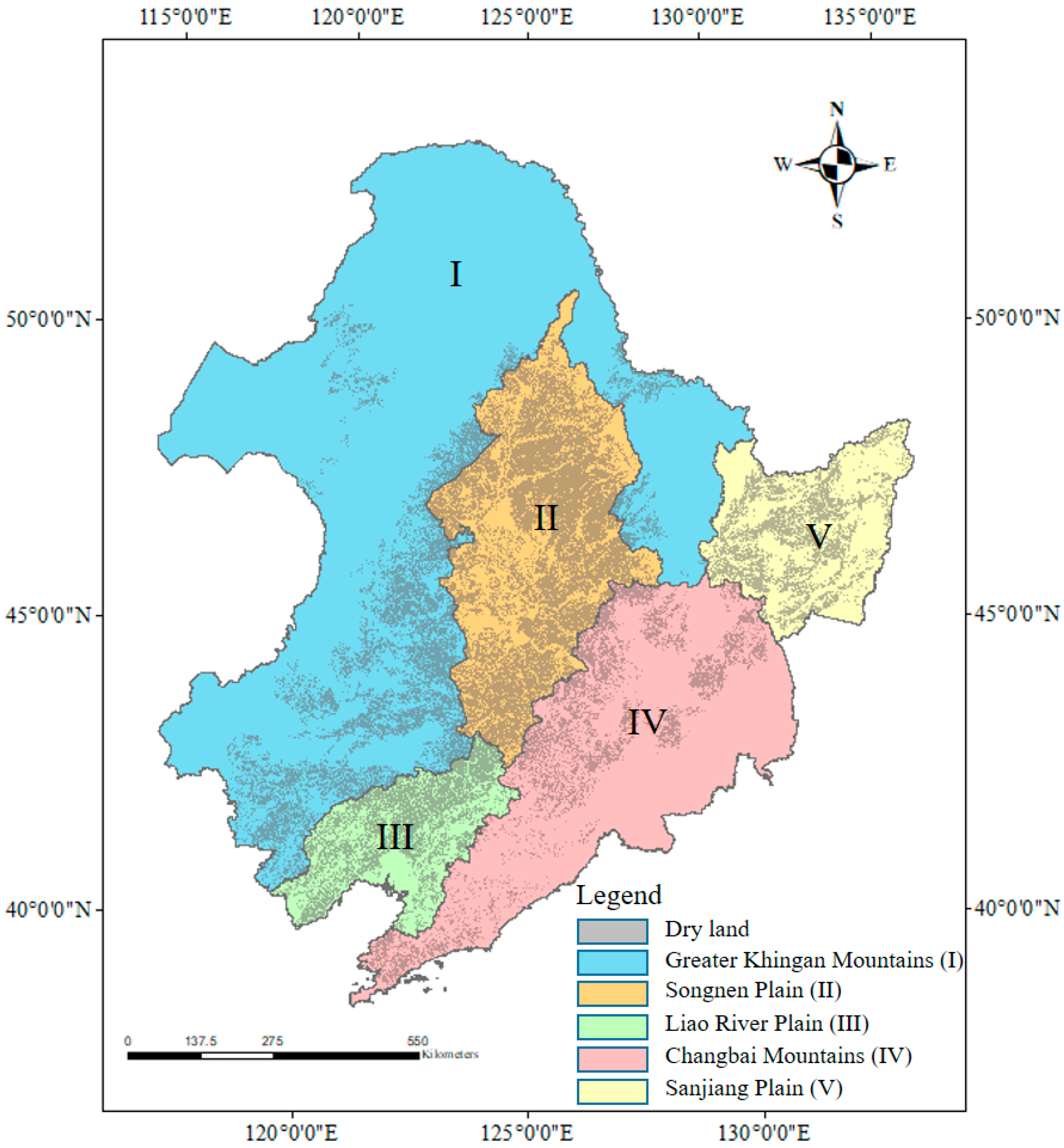
2.1. Study Area
2.2. Data Resource and Processing
2.3. RUSLE Model
2.4. RWEQ Model
2.5. Subsection
2.6. Model Accuracy
3. Results
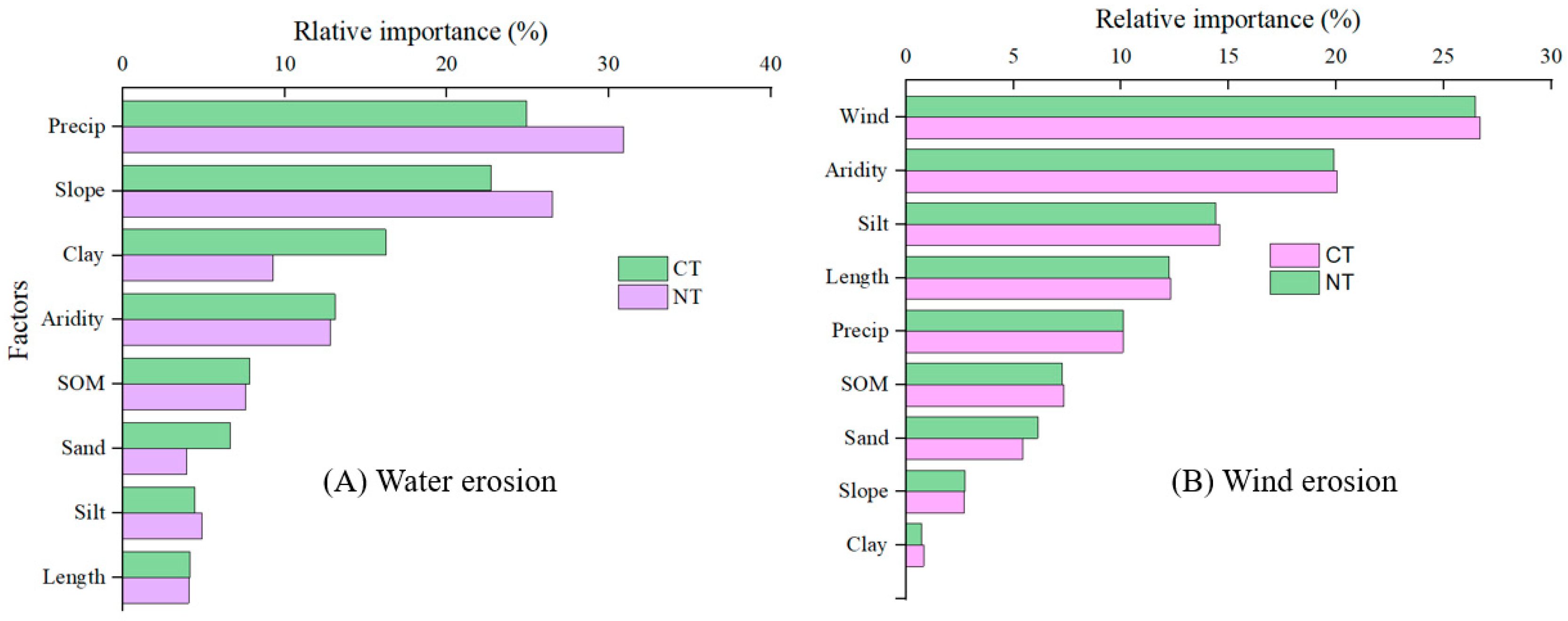
3.1. Model Factors
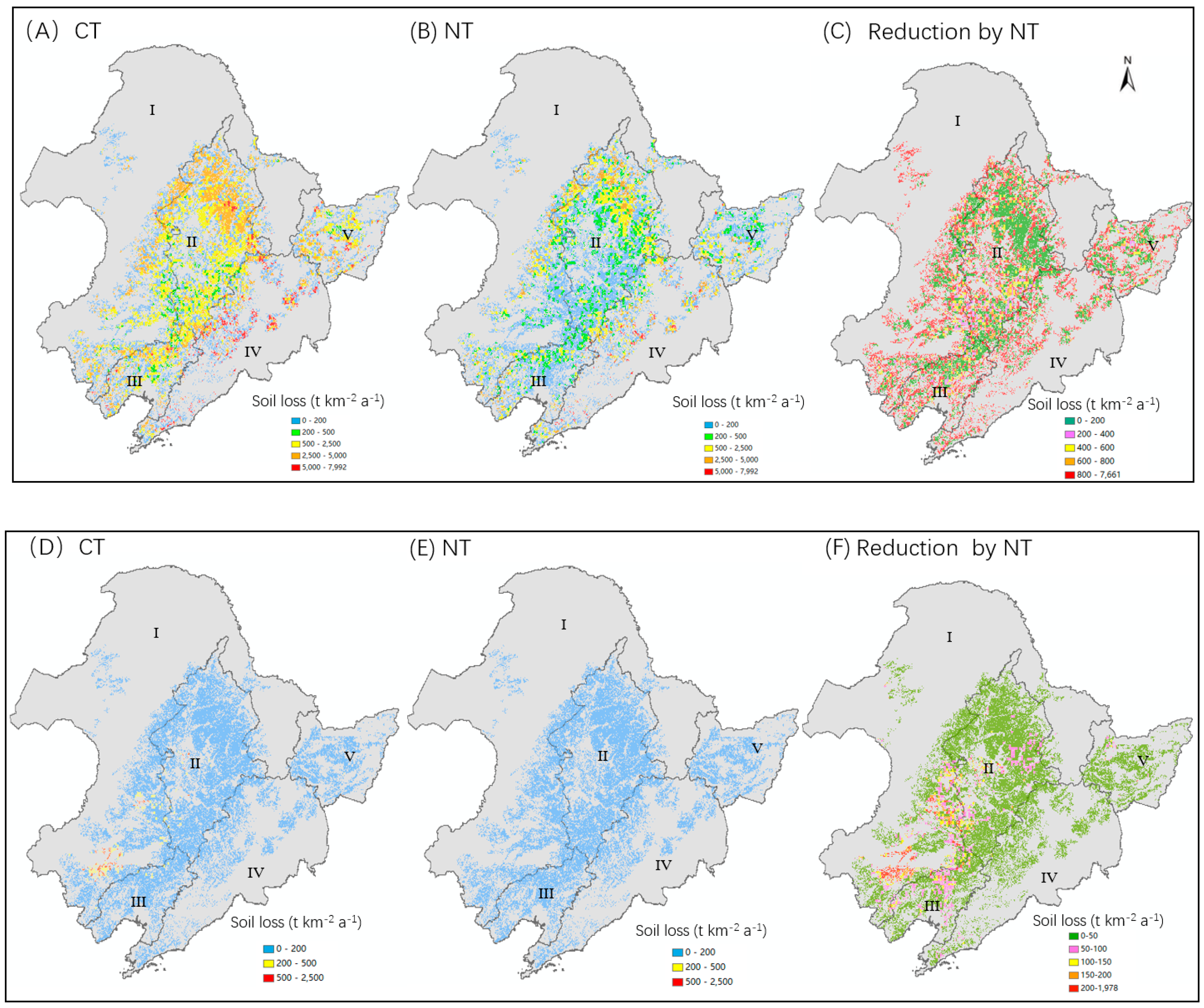
3.2. Spatial Patterns of Soil Erosion as Affected by NT Practice
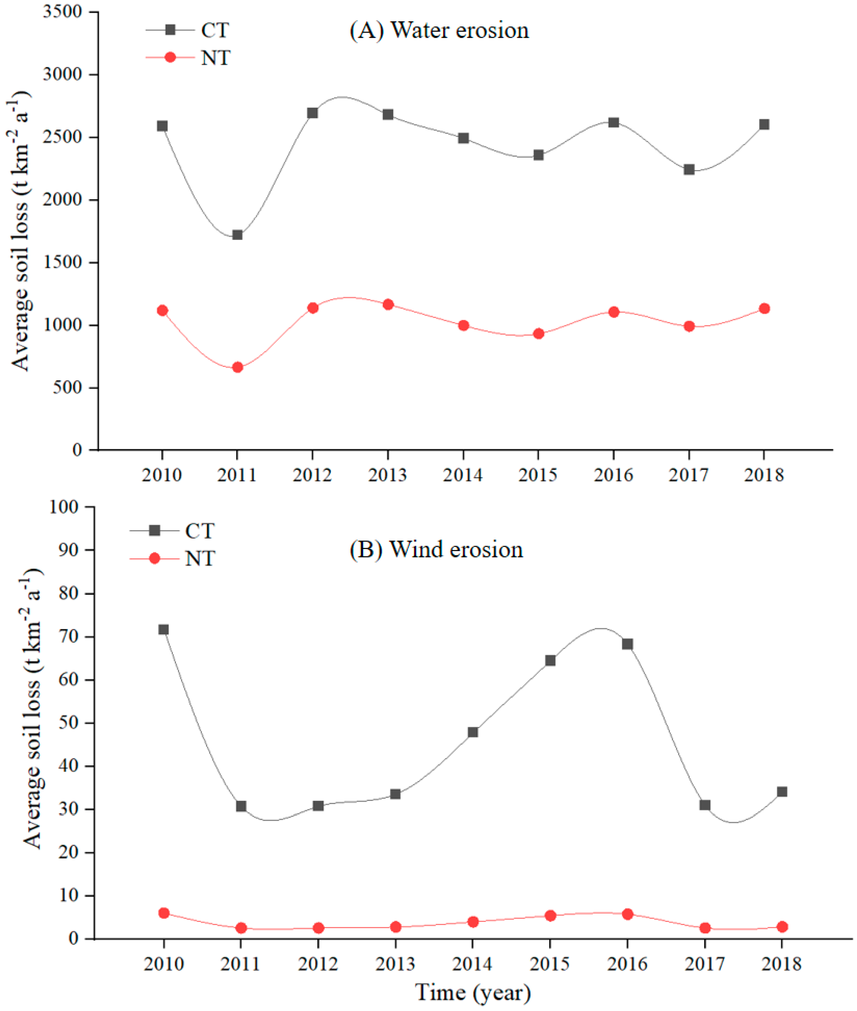
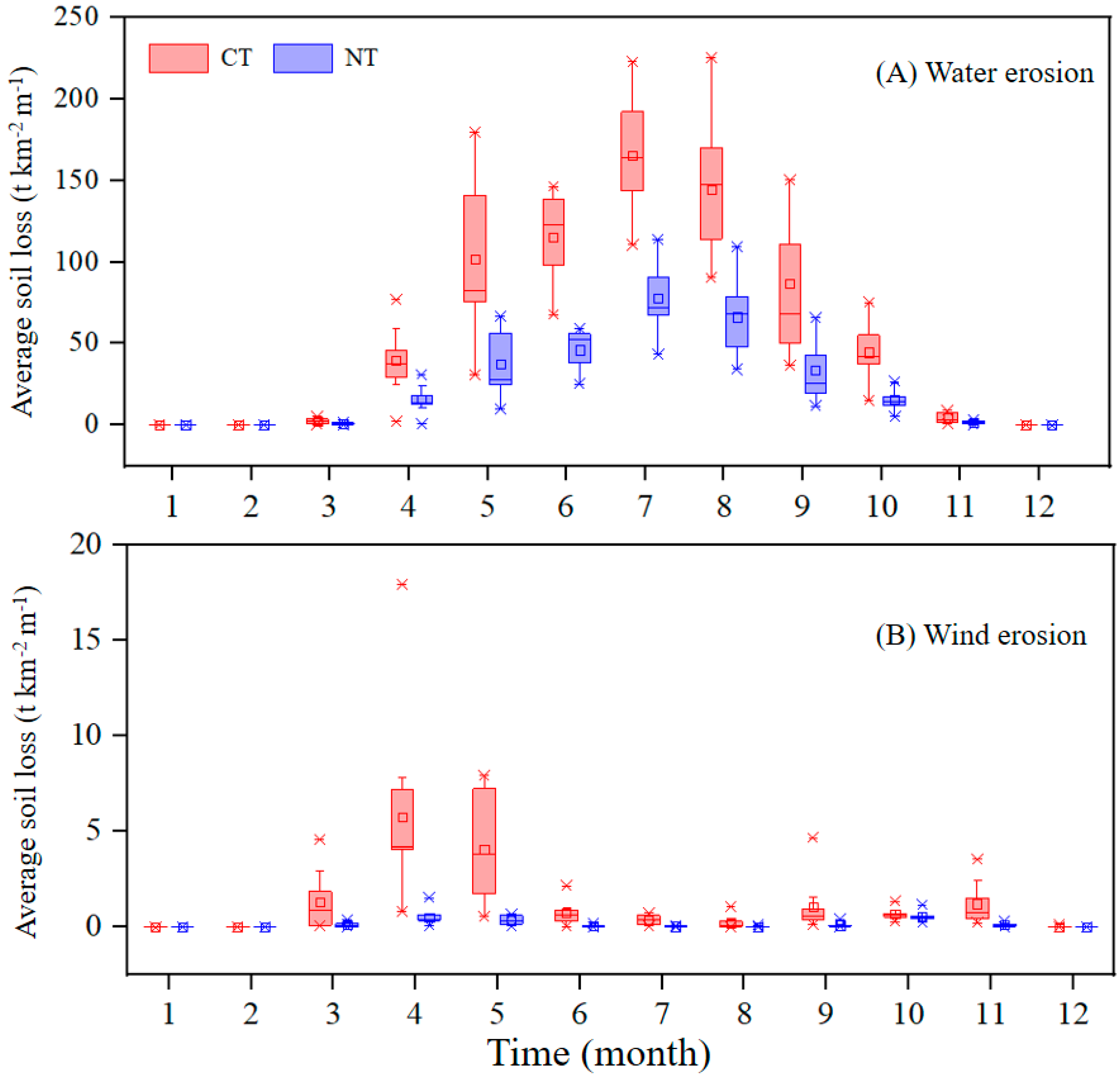
3.3. Temporal Dynamics of Soil Erosion as Affected by NT Practice
3.4. Influence of Various Factors on Soil Erosion as Affected by NT Practice
4. Discussion
4.1. Model Validation
4.2. Spatial Patterns of Soil Erosion as Affected by NT Practice
4.3. Temporal Dynamics of Soil Erosion as Affected by NT Practice
4.4. The Implementation of NT Practice in Northeast China
5. Conclusions
Supplementary Materials
Author Contributions
Funding
Data Availability Statement
Conflicts of Interest
References
- Borrelli, P.; Robinson, D.A.; Fleischer, L.R.; Lugato, E.; Ballabio, C.; Alewell, C.; Meusburger, K.; Modugno, S.; Schutt, B.; Ferro, V.; et al. An assessment of the global impact of 21st century land use change on soil erosion. Nat. Commun. 2017, 8, 2013. [Google Scholar] [CrossRef] [PubMed]
- Yang, G.; Sun, R.; Jing, Y.; Xiong, M.; Li, J.; Chen, L. Global assessment of wind erosion based on a spatially distributed RWEQ model. Prog. Phys. Geogr. 2021, 46, 28–42. [Google Scholar] [CrossRef]
- Chi, W.; Zhao, Y.; Kuang, W.; He, H. Impacts of anthropogenic land use/cover changes on soil wind erosion in China. Sci. Total Environ. 2019, 668, 204–215. [Google Scholar] [CrossRef] [PubMed]
- Lu, S.; Duan, X.; Wei, S.; Lin, H. An insight to calculate soil conservation service. Geogr. Sustain. 2022, 3, 237–245. [Google Scholar] [CrossRef]
- Li, C.; Fu, B.; Wang, S.; Stringer, L.C.; Wang, Y.; Li, Z.; Liu, Y.; Zhou, W. Drivers and impacts of changes in China’s drylands. Nat. Rev. Earth Environ. 2021, 2, 858–873. [Google Scholar] [CrossRef]
- Li, Z.; Wang, S.; Li, C.; Ye, C.; Gao, D.; Chen, P. The trend shift caused by ecological restoration accelerates the vegetation greening of China’s drylands since the 1980s. Environ. Res. Lett. 2022, 17, 044062. [Google Scholar] [CrossRef]
- Wang, S.; Xu, X.; Huang, L. Spatial and Temporal Variability of Soil Erosion in Northeast China from 2000 to 2020. Remote Sens. 2022, 15, 225. [Google Scholar] [CrossRef]
- Wang, H.; Yang, S.; Wang, Y.; Gu, Z.; Xiong, S.; Huang, X.; Sun, M.; Zhang, S.; Guo, L.; Cui, J.; et al. Rates and causes of black soil erosion in Northeast China. Catena 2022, 214, 106250. [Google Scholar] [CrossRef]
- Chen, X.W.; Liang, A.Z.; Jia, S.X.; Zhang, X.P.; Wei, S.C. Impact of tillage on physical characteristics in a Mollisol of Northeast China. Plant Soil Environ. 2014, 60, 309–313. [Google Scholar] [CrossRef]
- He, C.; Niu, J.R.; Xu, C.T.; Han, S.W.; Bai, W.; Song, Q.L.; Dang, Y.P.; Zhang, H.L. Effect of conservation tillage on crop yield and soil organic carbon in Northeast China: A meta-analysis. Soil Use Manag. 2022, 38, 1146–1161. [Google Scholar] [CrossRef]
- Zhao, P.; Li, S.; Wang, E.; Chen, X.; Deng, J.; Zhao, Y. Tillage erosion and its effect on spatial variations of soil organic carbon in the black soil region of China. Soil Tillage Res. 2018, 178, 72–81. [Google Scholar] [CrossRef]
- Zhang, S.; Zhang, X.; Huffman, T.; Liu, X.; Yang, J. Soil Loss, Crop Growth, and Economic Margins under Different Management Systems on a Sloping Field in the Black Soil Area of Northeast China. J. Sustain. Agric. 2011, 35, 293–311. [Google Scholar] [CrossRef]
- Wang, J.; Shi, X.; Li, Z.; Zhang, Y.; Liu, Y.; Peng, Y. Responses of runoff and soil erosion to planting pattern, row direction, and straw mulching on sloped farmland in the corn belt of northeast China. Agric. Water Manag. 2021, 253, 106935. [Google Scholar] [CrossRef]
- Jia, H.; Wang, G.; Guo, L.; Zhuang, J.; Tang, L. Wind erosion control utilizing standing corn residue in Northeast China. Soil Tillage Res. 2015, 153, 112–119. [Google Scholar] [CrossRef]
- Chen, S.; Zhang, X.; Li, J.; Guo, M.; Hu, W. Effect of tillage management on the wind erosion of arable soil in the Chinese Mollisol region. Front. Environ. Sci. 2022, 10, 954004. [Google Scholar] [CrossRef]
- Brooks, E.S.; Dobre, M.; Elliot, W.J.; Wu, J.Q.; Boll, J. Watershed-scale evaluation of the Water Erosion Prediction Project (WEPP) model in the Lake Tahoe basin. J. Hydrol. 2016, 533, 389–402. [Google Scholar] [CrossRef]
- Flanagan, D.C.; Ascough, J.C.; Nearing, M.A.; Laflen, J.M. The Water Erosion Prediction Project (WEPP) Model. In Landscape Erosion and Evolution Modeling; Harmon, R.S., Doe, W.W., Eds.; Springer: Boston, MA, USA, 2001; pp. 145–199. [Google Scholar]
- De Roo, A.P.J.; Offermans, R.J.E.; Cremers, N.H.D.T. LISEM: A single-event, physically based hydrological and soil erosion model for drainage basins. II: Sensitivity analysis, validation and application. Hydrol. Process. 1996, 10, 1119–1126. [Google Scholar] [CrossRef]
- Morgan, R.P.C.; Quinton, J.N.; Smith, R.E.; Govers, G.; Poesen, J.W.A.; Auerswald, K.; Chisci, G.; Torri, D.; Styczen, M.E. The European Soil Erosion Model (EUROSEM): A dynamic approach for predicting sediment transport from fields and small catchments. Earth Surf. Process. Landf. 1998, 23, 527–544. [Google Scholar] [CrossRef]
- Ghosal, K.; Das Bhattacharya, S. A Review of RUSLE Model. J. Indian Soc. Remote Sens. 2020, 48, 689–707. [Google Scholar] [CrossRef]
- Zhang, X.K.; Xu, J.H.; Lu, X.Q.; Deng, Y.J.; Gao, D.W. A study on the soil loss equation in Heilongjiang province. Bull. Soil Water Conserv. 1992, 12, 1–10, (In Chinese with English abstract). [Google Scholar]
- Jarrah, M.; Mayel, S.; Tatarko, J.; Funk, R.; Kuka, K. A review of wind erosion models: Data requirements, processes, and validity. Catena 2020, 187, 104388. [Google Scholar] [CrossRef]
- Zhang, Q.H. The effect of different tillage and cover crop on the loss of soil nutrients. Mod. Agri. 2014, 2, 18–21, (In Chinese with English abstract). [Google Scholar]
- Song, Y.; Zhang, Z.X. The effect of different tillage measures on soil erosion in slope farmland in black soil region. Res. Soil Water Conserv. 2011, 18, 14–16, (In Chinese with English abstract). [Google Scholar]
- Chen, G.; Li, S.Q.; Li, J.W.; Fan, H.F.; Xie, Y. The initial analysis of sedemient reduction under soil and water conservation practices in the black soil region of Northeast China. Soil Water Conser. Appl. 2006, 5, 46–48, (In Chinese with English abstract). [Google Scholar]
- Han, F.W.; Zhang, B.; Song, K.S.; Wang, Z.M.; Wang, Y.S.; Zhang, X.W. Study on the effect of soil erosion reduction corresponding to water and soil conservation measures in Heilongjiang low mountains area. Sys. Sci. Compre. Stu. Agri. 2007, 23, 407–410, (In Chinese with English abstract). [Google Scholar]
- Qi, Z.J.; Zhang, Z.X.; Yang, A.Z. Benefit of soil and water conservation measures on sloping land of black soils. Res. Soil Water Conser. 2011, 18, 72–75, (In Chinese with English abstract). [Google Scholar]
- Zhao, Y.S.; Wei, Y.X. Soil and water conservation effects of protective tillage measures on sloping farmland. Sci. Soil Water Conser. 2009, 7, 86–90, (In Chinese with English abstract). [Google Scholar]
- Wei, Y.X.; Li, X.D.; Hu, T.T. Soil and water conservation and water-saving and soybean yield-increasing effects of different conservation tillage technology modes in slopping farmland. J. NE. Agri. Uni. 2013, 44, 51–55, (In Chinese with English abstract). [Google Scholar]
- Tan, J.; Fan, H.M.; Xu, X.Q.; Jia, Y.F.; Wu, M. Comparison of practice values of soil and water conservation measures under the condition of snow melting and rainfall erosion. Res. Soil Water Conser. 2017, 24, 29–38, (In Chinese with English abstract). [Google Scholar]
- Han, F.W.; Zhang, B.; Wang, Z.M.; Song, K.S.; Li, J.P. Study on the effect of soil erosion reduction corresponding to water and soil conservation measures in Jilin low mountain and mound area. J. Jilin Agri. Uni. 2007, 29, 668–672, (In Chinese with English abstract). [Google Scholar]
- Li, F.; Li, X.G. The effect of different soil and water conservation tillage on runoff, sediment, and soil erosion. J. Soil Water Conser. 2022, 5, 142–146, (In Chinese with English abstract). [Google Scholar]
- Zhang, S.L.; Zhang, X.Y.; Liu, X.B.; Liu, S.; Yu, T.Y. Tillage effect on soil erosion in typical black soil region. J. Soil Water Conser. 2009, 23, 11–15, (In Chinese with English abstract). [Google Scholar]
- Zhang, X.Y.; Chen, Q.; Chen, Y.; Liu, S.; Li, X.F.; Li, H. Influence of no-tillage on soil and crop performance in the north cool region of Northeast China. Sci. Agri. Sini. 2013, 46, 2271–2277, (In Chinese with English abstract). [Google Scholar]
- Shi, Y.L.; Chen, Y.S.; Liu, J.X.; Fan, H. The study of different tillage practices on soil and water conservation in black soil region of Northeast China. Soil Water Conserv. China 2019, 1, 47–49, (In Chinese with English abstract). [Google Scholar]
- Wen, Y.H.; Wang, L.X.; Liu, T.J. Process of runoff and sediment generation on different slopes with ridged cropping in the black soil area of Northeast China. Res. Soil Water Conser. 2022, 29, 8–20, (In Chinese with English abstract). [Google Scholar]
- Lv, G.; Ban, X.F.; Lei, Z.Y.; Wu, X.Y. Benefit of soil and water conservation in the process of harnessing a sloping farmland in the black soil region, Northeast China. Sci. Soil Water Conser. 2009, 16, 51–55, (In Chinese with English abstract). [Google Scholar]
- Chen, G.; Fan, H.F.; Chen, H.S.; Dong, G.Q. Benefits of sediment reduction of soil conservation practices in the black soil region of Northeast China. Sci. Soil Water Conser. 2006, 4, 13–17, (In Chinese with English abstract). [Google Scholar]
- Su, M.M.; Wang, X.J.; Gao, H.S. Effects of tillage measures and nitrogen fertilizers on surface runoff, soil erosion and inorganic nitrogen loss in sloping land of black soil region. J. Soil Water Conser. 2017, 31, 58–65, (In Chinese with English abstract). [Google Scholar]
- Wang, B.T.; Ding, B.Q. The study of soil erosion protect tillage measures in the sloping land in the Northeast China. Water Res. Hydr. NE. 2008, 26, 64–66, (In Chinese with English abstract). [Google Scholar]
- Ou, Y.L.; Xie, Y.J.; Ge, W.F.; Ju, M.R.; Chen, Y.Z. The water and soil conservation measures in the east and low mountains areas in the Heilongjiang. Water Soil Conser. Tech. 2018, 6, 8–10, (In Chinese with English abstract). [Google Scholar]
- Gai, H.; Liu, P.Q.; Zhang, M.X.; Chen, B.X.; Wang, Y.C.; Wang, L.G. Effects of ridge planting on reducing runoff and soil organic carbon loss in black soil slope. J. Soil Water Conser. 2022, 36, 300–311, (In Chinese with English abstract). [Google Scholar]
- Xu, X.H.; Sui, Y.Y.; Zhang, Y.; Wang, Y.F.; Liu, M.Y.; Liu, Y.J. Effects of different tillage on the soil and water conservation benefits in Northeast black soil area of China. Sci. Soil Water Conser. 2013, 11, 12–16, (In Chinese with English abstract). [Google Scholar]
- Mou, Y.S.; Shen, H.O.; He, Y.F.; Li, C.L.; Guo, R.; Liu, D.M. Effects of ridge tillage patterns on soil erosion of sloping croplands in black soil region of Northeast China. Bull. Soil Water Conser. 2022, 42, 22–30, (In Chinese with English abstract). [Google Scholar]
- He, Y.F.; Shen, H.O.; Zhang, Y.; Zhao, Z.J.; Mou, Y.S. Analysis of soil and water conservation effects of different straw returning patterns in sloping farmland in the Chinese black soil region. J. Soil Water Conser. 2020, 34, 89–94, (In Chinese with English abstract). [Google Scholar]
- Niu, X.L.; Qin, F.C.; Yan, Z.Q.; Li, L.; Li, X.Q.; Liu, L.C. Efficacy of several tillage in conserving soil and water in slopping areas at the black soil in Northeast China. J. Irr. Dra. 2019, 38, 67–72, (In Chinese with English abstract). [Google Scholar]
- Li, F.; Han, X.; Ma, X.L.; Wang, Y.J.; Song, T.Q.; Wang, Y.Y. Straw mulch controls runoff and nitrogen and phosphorus loss from slope farmland in black soil region of northeast China. J. Soil Water Conser. 2020, 34, 37–42, (In Chinese with English abstract). [Google Scholar]
- Yang, Q.S.; Zhen, F.L.; Wen, L.L.; Gen, X.D.; An, J.; Wang, B. Effects of mulch cover on hillslope soil erosion and nutrient loss in black soil region of Northeast China. Bull. Soil Water Conser. 2011, 31, 1–5, (In Chinese with English abstract). [Google Scholar]
- Cao, Y.S.; Li, H.P.; Xiao, B. Effect of straw mulching on soil and water loss under different soil bulk densities on slope cropland in black soil region. Bull. Soil Water Conser. 2021, 41, 56–61, (In Chinese with English abstract). [Google Scholar]
- He, C.; Wang, L.; Zhen, F.L.; He, X.; Fu, H. Effects of ridge tillage on hillslope soil erosion in Thin layer black soil region. J. Soil Water Conser. 2018, 32, 24–28, (In Chinese with English abstract). [Google Scholar]
- Chen, Y.; Zhang, Y.Y.; Li, S.X. Comparative study on conservational tillage in slope and flat farmland. Sys. Sci. Comp. Stu. Agri. 2011, 27, 485–489, (In Chinese with English abstract). [Google Scholar]
- Sui, Y.Y.; Ou, Y.; Yan, B.X.; Xu, X.H.; Rousseau, A.N.; Zhang, Y. Assessment of micro-basin tillage as a soil and water conservation practice in the black soil region of Northeast China. PLoS ONE 2016, 11, 1–16, (In Chinese with English abstract). [Google Scholar] [CrossRef] [PubMed]
- Chai, Y.; Wei, Y.X.; Zhang, B.L.; Bai, Y. Impacts of slopping farm land management measures and their combination on soil and water environment and nutrient loss. Agri. Mech. Stu. 2015, 1, 177–182, (In Chinese with English abstract). [Google Scholar]
- Chen, Q.; Yuriy, S.K.; Chen, Y.; Li, X.F.; Li, H.; Song, C.Y.; Zhang, X.Y. Seasonal variations of soil structures and hydraulic conductivities and their effects on soil and water conservation under no-tillage and reduced tillage. Acta Pedologica Sinica 2015, 51, 11–21, (In Chinese with English abstract). [Google Scholar]
- Yang, S.Q.; Xin, L.; Liu, H.Y.; Han, R.Y.; Yan, L.Z. Effect of planting patterns on soil nitrogen and phosphorus loss in slope farmland in the main Songhua river basin. J. NW Uni. 2018, 46, 61–69, (In Chinese with English abstract). [Google Scholar]
- Mou, T.S.; Shen, H.O.; Wang, D.L.; Zhang, Y.; Wu, J.L.; Huang, Z.Y. Effects of crushed corn straw returning on soil erosion characteristics at the black soil hillslopes. J. Soil Water Conser. 2022, 36, 78–91, (In Chinese with English abstract). [Google Scholar]
- Zhang, X.Y.; Li, J.Y.; Guo, M.J.; Hu, W.; Li, J.Y. Effects of straw mulching and no tillage for continuous 14 years on soil and water conservation in mollisols sloping farmland. J. Soil Water Conser. 2022, 36, 44–50, (In Chinese with English abstract). [Google Scholar]
- Xu, X.M.; Zhang, F.L.; Wilson, G.V.; He, C.; Lu, J.; Bian, F. Comparison of runoff and soil loss in different tillage systems in the Mollisol region of Northeast China. Soil Till. Res. 2018, 177, 1–11. [Google Scholar] [CrossRef]
- Chen, S.; Burras, C.L.; Li, L.E.; Zhang, X.Y. Interrelationship among slope steepness, tillage practice and rainfall properties with surface runoff and soil loss on Mollisols in Northeast China. Arch. Agron. Soil Sci. 2019, 65, 1860–1872. [Google Scholar] [CrossRef]
- Yang, X.M.; Zhang, X.P.; Deng, W.; Fang, H.J. Black soil degradation by rainfall erosion in Jilin, China. Land Degra. Deve. 2003, 14, 409–420. [Google Scholar] [CrossRef]
- Li, H.L.; Shen, H.O.; Wang, Y.; Wang, Y.; Gao, Q. Effect of ridge tillage and straw returning on runoff and soil loss under simulated rainfall in the Mollisol region of Northeast China. Sustainability 2021, 13, 10614. [Google Scholar] [CrossRef]
- Dai, T.Y.; Wang, L.Q.; Li, T.N.; Qiu, P.P.; Wang, J. Study on the characteristics of soil erosion in the black soil area of Northeast China under natural rainfall conditions: The case of Sunjiagou small watershed. Sustainability 2022, 14, 8284. [Google Scholar] [CrossRef]
- Zhang, Y.J. Effects of conservation tillage on soil and water loss from sloping farmland in Heibeishan watershed. Bull. Soil Water Conser. 2012, 32, 103–105, (In Chinese with English abstract). [Google Scholar]
- Jiang, B.W.; Zhao, S.D.; Dan, W.; Jin, L.; Li, Y.M.; Guo, W.Y.; Xu, M.; Zhang, Z. Effect of slope and tillage measures on soil erosion and yield of soybean. Soyb. Sci. 2015, 34, 238–242, (In Chinese with English abstract). [Google Scholar]
- Yang, A.M.; Shen, C.P.; Liu, F.; Yin, J.F.; Den, Y.J. Study on soil and water conservation benefit of contour check in sloping field. J. Soil Water Conser. 1994, 8, 52–58, (In Chinese with English abstract). [Google Scholar]
- Yang, R.C. Monitoring study on wind erosion in Hailun of the typical Mollisols farmland in Northeast China. Master’s Thesis, Northeast Agricultural University, Harbin, China, 2018. (In Chinese with English abstract). [Google Scholar]
- Chu, Z.D.; Xie, R.Z.; Li, S.K.; Wang, K.R.; Liu, W.R.; Zhang, J.Y. Spring corn conservation tillage effects of the ageing resistant film mulch and the alternative fallow remaining high stubble in Northeast of China. J. Mai. Sci. 2018, 18, 70–72, (In Chinese with English abstract). [Google Scholar]
- Wang, Y.; Yan, M.Y.; Liu, P.L. Contribution partition of water and wind erosion on cultivated slopes in northeast black soil region of China. J. Nuc. Agri. Sci. 2010, 24, 790–795, (In Chinese with English abstract). [Google Scholar]
- Tuo, D.B.; Duan, Y.; Zhao, P.Y.; Zheng, D.W.; Chen, M.; Zhao, J. Ecological effect of intercropping strips keeping stubble on preventing field from wind erosion in dryland farming areas. Acta Agri. Bore. Sini. 2002, 17, 63–67, (In Chinese with English abstract). [Google Scholar]
- Li, S.L.; Li, H.P.; Lin, Y.; Xiao, B.; Wang, G.P. Effects of tillage methods on wind erosion in farmland of Northeast China. J. Soil Water Conser. 2019, 33, 110–118, (In Chinese with English abstract). [Google Scholar]
- Zhao, J.; Zhang, L.F.; Liu, J.H.; Li, M. Effect of conservation tillage on soil moisture and wind blow mass. J. Anhui Agri. Sci. 2010, 38, 4720–4728, (In Chinese with English abstract). [Google Scholar]
- Wang, G. Conservation tillage with standing corn residue and its corresponding corn harvester. Phd Thesis, Jilin University, Changchun, China, 2016. (In Chinese with English abstract). [Google Scholar]
- Cui, X. The critical technic of conservation tillage in the Liao River conservational region. Agri. Sci. Tech. Equip. 2015, 04, 7–12, (In Chinese with English abstract). [Google Scholar]
- Lv, Z.C. Effect of Liaoning Northwest different agricultural measures on soil erosion sowing. Jilin Water Technic. 2015, 10, 24–26, (In Chinese with English abstract). [Google Scholar]
- Qin, H.L.; Gao, W.S.; Ma, Y.C.; Zhao, P.Y. Effect of standing crop stubble on soil erosion by wind under no-tillage. Tran. CSAE. 2008, 24, 66–71, (In Chinese with English abstract). [Google Scholar]
- Chang, X.H.; Zhao, G.C.; Zhang, W.; Hou, L.B.; Meng, X.Y.; Yuan, B.L. Effect of crop stubble mulch on farmland wind erosion. J. Soil Water Conser. 2005, 19, 28–30, (In Chinese with English abstract). [Google Scholar]
- Borrelli, P.; Panagos, P.; Alewell, C.; Ballabio, C.; de Oliveira Fagundes, H.; Haregeweyn, N.; Lugato, E.; Maerker, M.; Poesen, J.; Vanmaercke, M.; et al. Policy implications of multiple concurrent soil erosion processes in European farmland. Nat. Sustain. 2022, 6, 103–112. [Google Scholar] [CrossRef]
- Zhang, W.B.; Xie, Y.; Liu, B.Y. Rainfall erosivity estimation using daily rainfall amounts. Sci. Geogr. Sin. 2002, 22, 705–711, (In Chinese with English abstract). [Google Scholar]
- Li, J.; Yu, W.; Du, J.; Song, K.; Xiang, X.; Liu, H.; Zhang, Y.; Zhang, W.; Zheng, Z.; Wang, Y.; et al. Mapping Maize Tillage Practices over the Songnen Plain in Northeast China Using GEE Cloud Platform. Remote Sens. 2023, 15, 1461. [Google Scholar] [CrossRef]
- Scheper, S.; Weninger, T.; Kitzler, B.; Lackóová, L.; Cornelis, W.; Strauss, P.; Michel, K. Comparison of the Spatial Wind Erosion Patterns of Erosion Risk Mapping and Quantitative Modeling in Eastern Austria. Land 2021, 10, 974. [Google Scholar] [CrossRef]
- Wang, Y.; Zhang, Z.; Guo, Z.; Chen, Y.; Yang, J.; Peng, X. In-situ measuring and predicting dynamics of soil bulk density in a non-rigid soil as affected by tillage practices: Effects of soil subsidence and shrinkage. Soil Tillage Res. 2023, 234, 105818. [Google Scholar] [CrossRef]
- Zhang, X.; Zhang, W.C.; Wu, W.; Liu, H.B. Horizontal and vertical variation of soil clay content and its controlling factors in China. Sci. Total Environ. 2023, 864, 161141. [Google Scholar] [CrossRef]
- Wang, X.; Zhao, X.; Zhang, Z.; Yi, L.; Zuo, L.; Wen, Q.; Liu, F.; Xu, J.; Hu, S.; Liu, B. Assessment of soil erosion change and its relationships with land use/cover change in China from the end of the 1980s to 2010. Catena 2016, 137, 256–268. [Google Scholar] [CrossRef]
- Wang, B.; Zhao, X.; Wang, X.; Zhang, Z.; Yi, L.; Hu, S. Spatial and temporal variability of soil erosion in the black soil region of Northeast China from 2000 to 2015. Environ. Monit. Assess. 2020, 192, 370. [Google Scholar] [CrossRef] [PubMed]
- Shen, Y.; Gu, J.; Liu, G.; Wang, X.; Shi, H.; Shu, C.; Zhang, Q.; Guo, Z.; Zhang, Y. Predicting soil erosion and deposition on sloping farmland with different shapes in northeast China by using 137 Cs. Catena 2023, 229, 107238. [Google Scholar] [CrossRef]
- Ryken, N.; Vanden Nest, T.; Al-Barri, B.; Blake, W.; Taylor, A.; Bodé, S.; Ruysschaert, G.; Boeckx, P.; Verdoodt, A. Soil erosion rates under different tillage practices in central Belgium: New perspectives from a combined approach of rainfall simulations and 7 Be measurements. Soil Tillage Res. 2018, 179, 29–37. [Google Scholar] [CrossRef]
- Zhang, X.C.J. Cropping and Tillage Systems Effects on Soil Erosion under Climate Change in Oklahoma. Soil Sci. Soc. Am. J. 2012, 76, 1789–1797. [Google Scholar] [CrossRef]
- Bhatt, R.; Khera, K.L. Effect of tillage and mode of straw mulch application on soil erosion in the submontaneous tract of Punjab, India. Soil Tillage Res. 2006, 88, 107–115. [Google Scholar] [CrossRef]
- Pei, L.; Wang, C.; Sun, L.; Wang, L. Temporal and Spatial Variation (2001–2020) Characteristics of Wind Speed in the Water Erosion Area of the Typical Black Soil Region, Northeast China. Int. J. Environ. Res. Public Health 2022, 19, 10473. [Google Scholar] [CrossRef] [PubMed]
- Xu, S.; Fu, Q.; Li, T.; Meng, F.; Liu, D.; Hou, R.; Li, M.; Li, Q. Spatiotemporal characteristics of the soil freeze-thaw state and its variation under different land use types—A case study in Northeast China. Agric. For. Meteorol. 2022, 312, 108737. [Google Scholar] [CrossRef]
- Liu, G.; Qu, M.; Feng, G.; Chu, Q.; Cao, J.; Yang, J.; Cao, L.; Feng, Y. Application study of monthly precipitation forecast in Northeast China based on the cold vortex persistence activity index. Theor. Appl. Climatol. 2018, 135, 1079–1090. [Google Scholar] [CrossRef]
- Ellison, W.D. Soil Erosion by Rainstorms. Science 1950, 111, 245–249. [Google Scholar] [CrossRef]
- Chalise, D.; Kumar, L.; Sharma, R.; Kristiansen, P. Assessing the Impacts of Tillage and Mulch on Soil Erosion and Corn Yield. Agronomy 2020, 10, 63. [Google Scholar] [CrossRef]
- Dong, Y.; Xuan, F.; Huang, X.; Li, Z.; Su, W.; Huang, J.; Li, X.; Tao, W.; Liu, H.; Chen, J. A 30-m annual corn residue coverage dataset from 2013 to 2021 in Northeast China. Sci. Data 2024, 11, 216. [Google Scholar] [CrossRef] [PubMed]
- Li, R.; Zheng, J.; Xie, R.; Ming, B.; Peng, X.; Luo, Y.; Zheng, H.; Sui, P.; Wang, K.; Hou, P.; et al. Potential mechanisms of maize yield reduction under short-term no-tillage combined with residue coverage in the semi-humid region of Northeast China. Soil Tillage Res. 2022, 217, 105289. [Google Scholar] [CrossRef]
- Jiang, F.; Qian, Y.; Guo, Z.; Gao, L.; Zhang, Z.; Cao, Z.; Guo, J.; Liu, F.; Peng, X. Evaluating the regional suitability of conservation tillage and deep tillage based on crop yield in the black soil of Northeast China: A meta-analysis. Acta Pedol. Sin. 2022, 59, 935–952, (In Chinese with English abstract). [Google Scholar]


| Regions | Water Erosion (t km−2 a−1) | Wind Erosion (t km−2 a−1) | ||||
|---|---|---|---|---|---|---|
| CT | NT | Reduction | CT | NT | Reduction | |
| I | 2196 | 999 | 1206 | 70 | 6 | 64 |
| II | 2279 | 829 | 1457 | 24 | 2 | 22 |
| III | 2327 | 821 | 1508 | 40 | 3 | 37 |
| IV | 4370 | 2470 | 1895 | 7 | 1 | 6 |
| V | 2454 | 959 | 1489 | 13 | 1 | 12 |
| Total | 2603 | 1134 | 1511 | 34 | 2.8 | 28.2 |
| Erosion | Tillage | Number | The Relationship between the Simulated and Observed Data | MAE | RMSE | R2 |
|---|---|---|---|---|---|---|
| Water | CT | 44 | y = 0.2377× −3.6909 | 891 | 1277 | 0.65 |
| NT | 39 | y = 0.0772× +53.263 | 409 | 916 | 0.56 | |
| Wind | CT | 5 | y = 1.1519× +110.45 | 262 | 425 | 0.15 |
| NT | 9 | y = 0.7060× −10.943 | 151 | 268 | 0.66 |
Disclaimer/Publisher’s Note: The statements, opinions and data contained in all publications are solely those of the individual author(s) and contributor(s) and not of MDPI and/or the editor(s). MDPI and/or the editor(s) disclaim responsibility for any injury to people or property resulting from any ideas, methods, instructions or products referred to in the content. |
© 2024 by the authors. Licensee MDPI, Basel, Switzerland. This article is an open access article distributed under the terms and conditions of the Creative Commons Attribution (CC BY) license (https://creativecommons.org/licenses/by/4.0/).
Share and Cite
Jiang, F.; Peng, X.; Li, Q.; Qian, Y.; Zhang, Z. Potential Reduction of Spatiotemporal Patterns of Water and Wind Erosion with Conservation Tillage in Northeast China. Land 2024, 13, 1219. https://doi.org/10.3390/land13081219
Jiang F, Peng X, Li Q, Qian Y, Zhang Z. Potential Reduction of Spatiotemporal Patterns of Water and Wind Erosion with Conservation Tillage in Northeast China. Land. 2024; 13(8):1219. https://doi.org/10.3390/land13081219
Chicago/Turabian StyleJiang, Fahui, Xinhua Peng, Qinglin Li, Yongqi Qian, and Zhongbin Zhang. 2024. "Potential Reduction of Spatiotemporal Patterns of Water and Wind Erosion with Conservation Tillage in Northeast China" Land 13, no. 8: 1219. https://doi.org/10.3390/land13081219