


Identification and Redevelopment of Inefficient Residential Landuse in Urban Areas: A Case Study of Ring Expressway Area in Harbin City of China

Abstract
1. Introduction
2. Study Area and Data Sources
2.1. Study Area
2.2. Data Sources
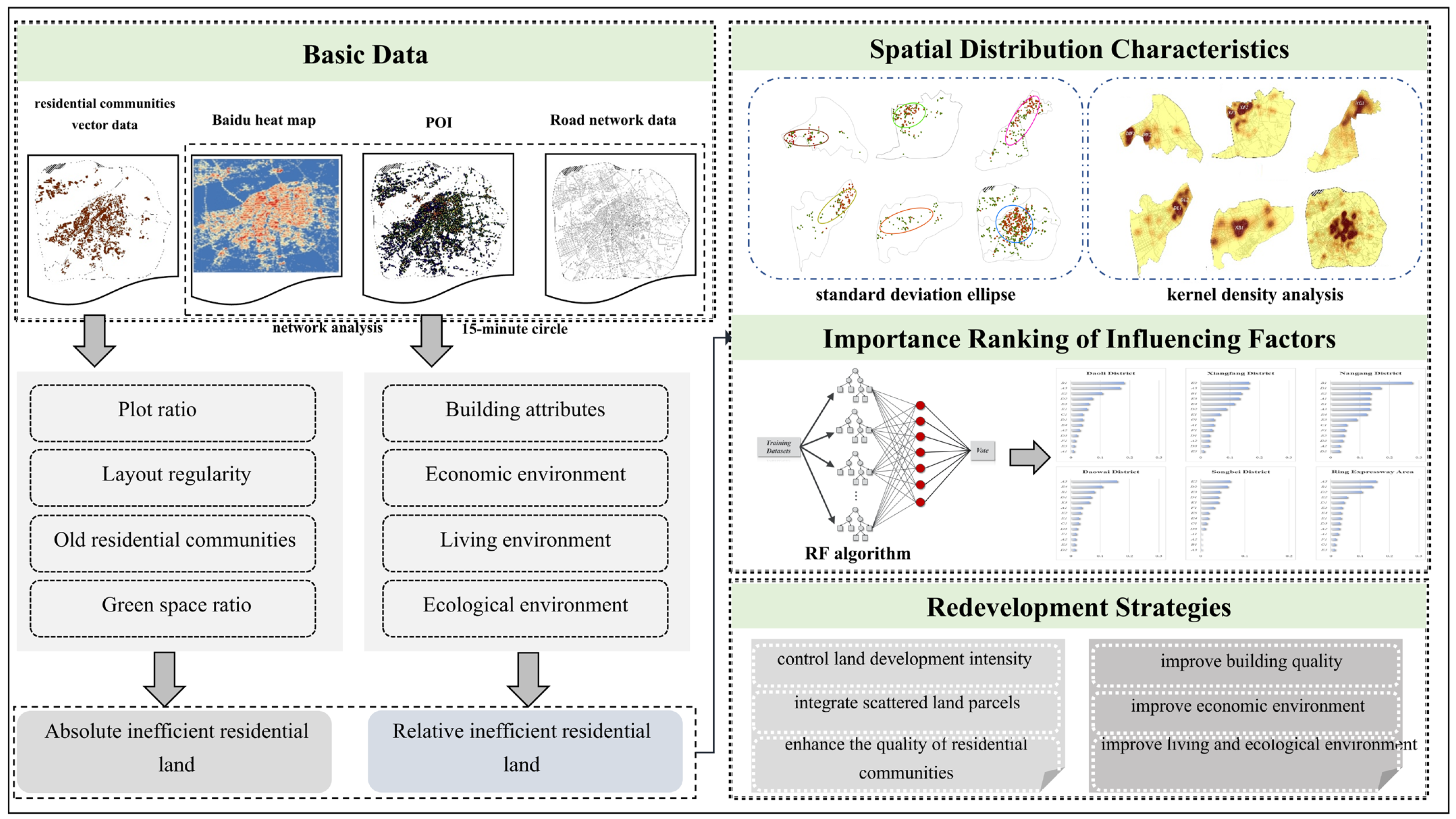
3. Methodology
3.1. Fundamental Principles
3.2. Construction of Evaluation Indicator System
3.3. Identification Criteria for Inefficient Residential Landuse
3.3.1. Criteria for Delineating Indicator Levels
3.3.2. Date Standardization Processing
3.3.3. Method for Indicator Weighting
3.3.4. Determination of Relatively Inefficient Residential Landuse
3.4. Research Methods of Spatial Distribution Characteristics
3.4.1. Standard Deviation Ellipse
3.4.2. Kernel Density Analysis
3.5. Importance Ranking
4. Results
4.1. Identification of Inefficient Residential Landuse
4.1.1. Identification of Absolutely Inefficient Residential Landuse
4.1.2. Identification of Relatively Inefficient Residential Landuse
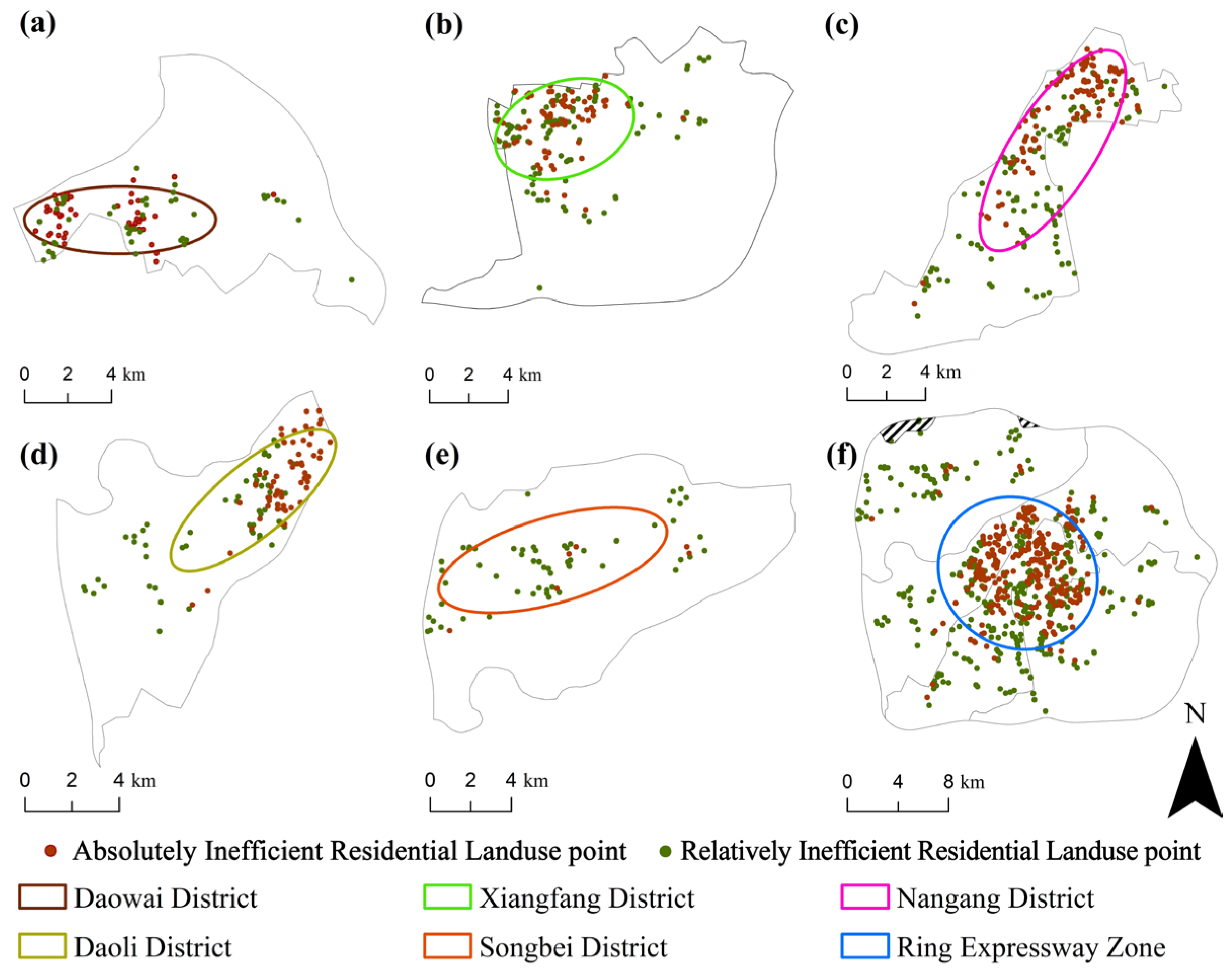
4.2. Spatial Distribution Characteristics of Inefficient Residential Landuse
4.2.1. Spatial Location and Orientation Characteristics of Inefficient Residential Landuse
4.2.2. Aggregation Form Characteristics of Inefficient Residential Landuse
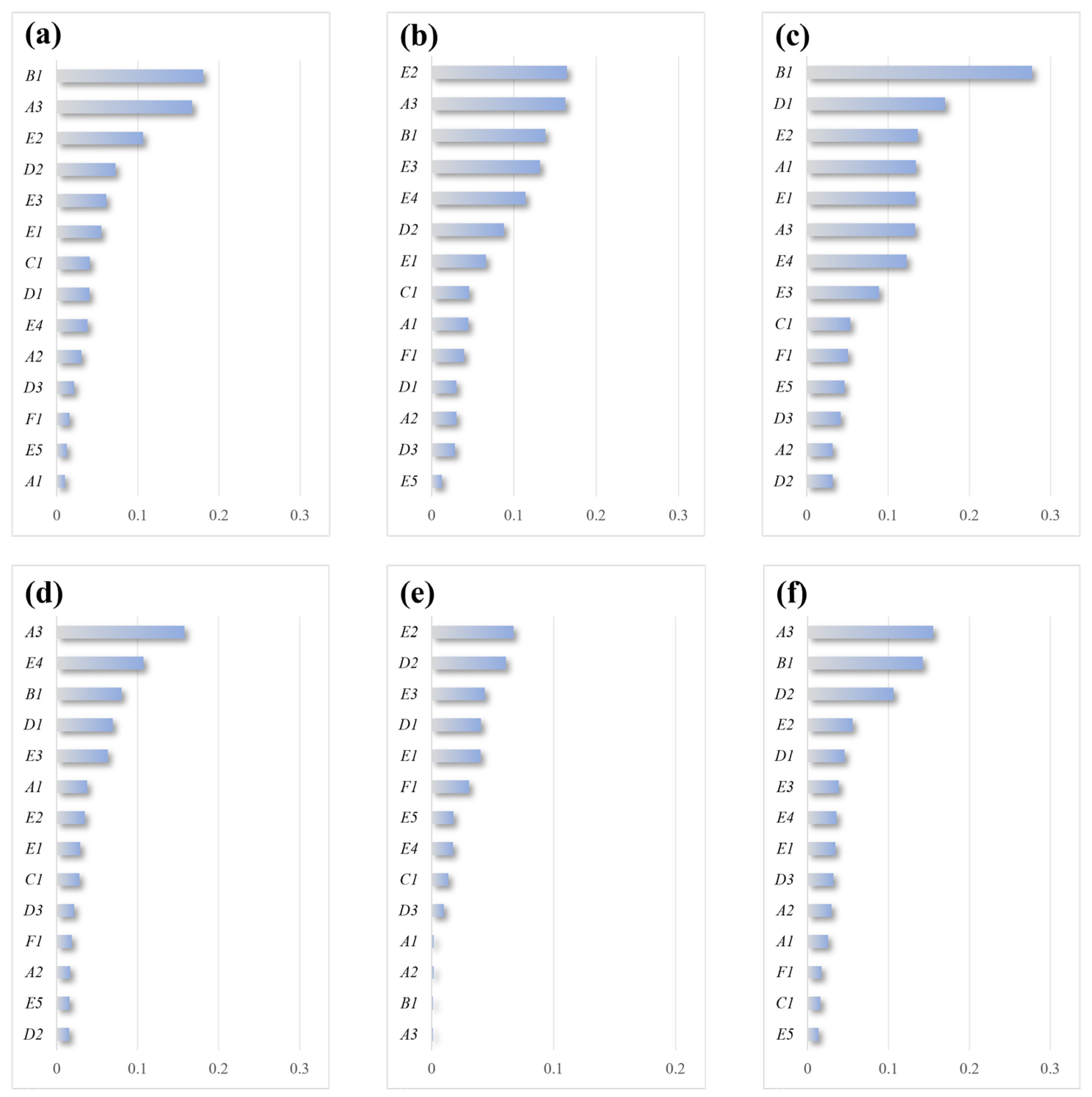
4.3. Importance Ranking of Influencing Factors
5. Discussion
5.1. Spatial Analysis of Inefficient Residential Landuse
5.2. Analysis of the Driving Factors behind Spatial Differences in Inefficient Residential Landuse
5.3. Strategies for Redeveloping Inefficient Residential Landuse
5.4. Advanced Methods for Analyzing Inefficient Residential Landuse
5.5. Adaptability and Considerations of the RF Algorithm in Urban Land Analysis
5.6. Limitations and Research Outlook
6. Conclusions
- (1)
- In the study area, inefficient residential landuse is mainly concentrated in the city center. Influenced by factors such as topography and urban historical development, residential land in Nangang District and Xiangfang District is predominantly located in the city center, leading to a higher prevalence of inefficient residential landuse in these areas. Additionally, Songbei District is notably affected by underdeveloped service facilities and geographical barriers, such as the Songhua River, which restrict the extension of central city services to this district. These lead to the higher proportion of relatively inefficient residential landuse in Songbei District.
- (2)
- The causes behind inefficient land use vary widely across different regions. In areas other than Songbei District, primary contributors to inefficiency include established residential communities and insufficient green space ratios. These issues often stem from outdated industrial locations and archaic housing design principles. In contrast, in Songbei District, inefficiencies in residential land primarily arise from deficiencies in essential services like healthcare and education. This pattern is typical in the early development phases of many new urban areas, where infrastructure lags behind residential growth.
- (3)
- Taking proactive redevelopment measures is crucial for enhancing land utilization efficiency and improving residents’ living experience. To improve absolutely inefficient residential landuse, comprehensive transformations should focus on controlling land development intensity, integrating scattered plots, enhancing community quality, and improving ecological environments. Conversely, for relatively inefficient residential landuse, the focus should be on upgrading building quality, enhancing economic, living, and ecological environments around neighborhoods.
Author Contributions
Funding
Institution Review Board Statement
Data Availability Statement
Acknowledgments
Conflicts of Interest
References
- Chen, M.; Liu, W.; Tao, X. Evolution and assessment on China’s urbanization 1960–2010: Under-urbanization or over-urbanization? Habitat Int. 2013, 38, 25–33. [Google Scholar] [CrossRef]
- Tan, Y.; Xu, H.; Zhang, X. Sustainable urbanization in China: A comprehensive literature review. Cities 2016, 55, 82–93. [Google Scholar] [CrossRef]
- Festus, I.A.; Omoboye, I.F.; Andrew, O.B. Humanities. Urban sprawl: Environmental consequence of rapid urban expansion. Malays. J. Soc. Sci. Humanit. 2020, 5, 110–118. [Google Scholar]
- Han, B.; Jin, X.; Wang, J.; Yin, Y.; Liu, C.; Sun, R.; Zhou, Y. Identifying inefficient urban land redevelopment potential for evidence-based decision making in China. Habitat Int. 2022, 128, 102661. [Google Scholar] [CrossRef]
- Zhao, S.; Da, L.; Tang, Z.; Fang, H.; Song, K.; Fang, J. Ecological consequences of rapid urban expansion: Shanghai, China. Front. Ecol. Environ. 2006, 4, 341–346. [Google Scholar] [CrossRef]
- Scolozzi, R.; Geneletti, D. A multi-scale qualitative approach to assess the impact of urbanization on natural habitats and their connectivity. Environ. Impact Assess. Rev. 2012, 36, 9–22. [Google Scholar] [CrossRef]
- Hasse, J.E.; Lathrop, R.G. Land resource impact indicators of urban sprawl. Appl. Geogr. 2003, 23, 159–175. [Google Scholar] [CrossRef]
- Shi, Y. The measurement index system of “urban disease” in China and its empirical analysis. Econ. Geogr. 2014, 34, 1–6. [Google Scholar]
- Fedorczak-Cisak, M.; Kowalska-Koczwara, A.; Pachla, F.; Radziszewska-Zielina, E.; Szewczyk, B.; Śladowski, G.; Tatara, T. Fuzzy model for selecting a form of use alternative for a historic building to be subjected to adaptive reuse. Energies 2020, 13, 2809. [Google Scholar] [CrossRef]
- McMichael, A.J. The urban environment and health in a world of increasing globalization: Issues for developing countries. Bull. World Health Organ. 2000, 78, 1117–1126. [Google Scholar] [PubMed]
- Hui, X.; Changfeng, L. Problems and suggestions on the redevelopment of urban stock construction land. Planners 2022, 38, 95–100. [Google Scholar]
- Liu, S.; Xiao, W.; Li, L.; Ye, Y.; Song, X. Urban land use efficiency and improvement potential in China: A stochastic frontier analysis. Land Use Policy 2020, 99, 105046. [Google Scholar] [CrossRef]
- Liu, J.; Hou, X.; Wang, Z.; Shen, Y. Study the effect of industrial structure optimization on urban land-use efficiency in China. Land Use Policy 2021, 105, 105390. [Google Scholar] [CrossRef]
- Jin, X.; Long, Y.; Sun, W.; Lu, Y.; Yang, X.; Tang, J. Evaluating cities’ vitality and identifying ghost cities in China with emerging geographical data. Cities 2017, 63, 98–109. [Google Scholar] [CrossRef]
- Cui, C.; Zhao, L.; Ren, H.; Ku, W.; Huang, Y. Integrating high-resolution remote sensing and street view images to identify urban villages: A case study in Yuexiu District, Guangzhou City. Natl. Remote Sens. Bull. 2022, 26, 1802–1813. [Google Scholar] [CrossRef]
- Mao, Y. Research on inefficient land use information extraction based on object-oriented classification: A case study of Jinjiang City, Fujian Province. Sci. Technol. Innov. Her. 2018, 15, 168–170. [Google Scholar]
- Yan, J.; Bi, R.; Xu, Z.; Lv, C.; Tian, H. Identification process and transformation strategy of urban inefficient land: Taking 14 townships(towns) in Qingshui Country, Shanxi Province as an example. Jiangsu Agric. Sci. 2020, 48, 284–290. [Google Scholar]
- Ding, Y.; Guo, Q.; Chen, Z.; Zhang, X. Identification and redevelopment strategy of underused urban land in underdeveloped counties using system theory. Trans. Chin. Soc. Agric. Eng. 2020, 36, 316–326. [Google Scholar]
- Cui, G.; Zheng, W.; Chen, S.; Dong, Y.; Huang, T. Study on the Spatial Pattern Characteristics and Influencing Factors of Inefficient Urban Land Use in the Yellow River Basin. Land 2022, 11, 1562. [Google Scholar] [CrossRef]
- Li, J.; Li, M.; Long, Y.; Dang, A. China polycentric cities based on Baidu Heatmap. Shanghai Urban Plan. Rev. 2016, 3, 30–36. [Google Scholar]
- Song, Y.; Lyu, Y.; Qian, S.; Zhang, X.; Lin, H.; Wang, S. Identifying urban candidate brownfield sites using multi-source data: The case of Changchun City, China. Land Use Policy 2022, 117, 106084. [Google Scholar] [CrossRef]
- Yao, Y.; Li, X.; Liu, X.; Liu, P.; Liang, Z.; Zhang, J.; Mai, K. Sensing spatial distribution of urban land use by integrating points-of-interest and Google Word2Vec model. Int. J. Geogr. Inf. Sci. 2017, 31, 825–848. [Google Scholar] [CrossRef]
- Wang, Z.; Wang, H.; Qin, F.; Han, Z.; Miao, C. Mapping an urban boundary based on multi-temporal Sentinel-2 and POI data: A case study of Zhengzhou City. Remote Sens. 2020, 12, 4103. [Google Scholar] [CrossRef]
- Zhan, X.; Ukkusuri, S.V.; Zhu, F.; Economics, S. Inferring urban land use using large-scale social media check-in data. Netw. Spat. Econ. 2014, 14, 647–667. [Google Scholar] [CrossRef]
- Dong, Y.; Chen, X.; Lv, D.; Wang, Q. Evaluation of urban green space supply and demand based on mobile signal data: Taking the central area of Shenyang city as an example. Land 2023, 12, 1742. [Google Scholar] [CrossRef]
- Shi, Y.; Yang, J.; Shen, P. Revealing the correlation between population density and the spatial distribution of urban public service facilities with mobile phone data. ISPRS Int. J. Geo. Inf. 2020, 9, 38. [Google Scholar] [CrossRef]
- Yang, J.; Shao, D.; Wang, Q.; Zhang, Y. Exploration on a method for precision identification of urban land use type using artificial intelligence: Based on big data of building forms and business POI data. City Plan. Rev. 2021, 45, 46–56. [Google Scholar]
- Sun, Y.; Xiao, D.; Huang, L. Exploration of the reconstruction of old residential districts in historical urban areas of Guangzhou under the concept of complete community. South Archit. 2023, 9, 62–69. [Google Scholar]
- Wang, Y.; Yuan, L.; Wang, G. Social problems and countermeasures of inefficient residential land in the process of urban renewal. China Collect. Econ. 2019, 19, 4–6. [Google Scholar]
- Liu, G.; Yi, Z.; Wei, L.; Hu, X. Evaluation of urban renewal policy based on policy instrument: Case in Shenzhen. Urban Dev. Stud. 2017, 24, 47–53. [Google Scholar]
- Ran, A.; Liu, J. Policy system of china’s old residential community renovation from the perspective of policy tool. Urban Dev. Stud. 2021, 28, 57–63. [Google Scholar]
- Liu, K.; Li, K.; Ye, Y. Redevelopment of underused land in built settlements: A study of settlement renewal and re-densification strategies of “Wohnen am Mittleren Ring” in Munich. Urban Plan. Int. 2024, 1–16. [Google Scholar] [CrossRef]
- He, X.; Zhang, Q.; Wang, M.; Yin, F. A practical exploration on renovation of old communities against the background of park city: A case study of old communities in Chengdu. City Plan. Rev. 2023, 47, 83–92. [Google Scholar]
- Strobl, C.; Malley, J.; Tutz, G. An introduction to recursive partitioning: Rationale, application, and characteristics of classification and regression trees, bagging, and random forests. Psychol. Methods 2009, 14, 323. [Google Scholar] [CrossRef] [PubMed]
- Redo, D.J.; Aide, T.M.; Clark, M.L. The relative importance of socioeconomic and environmental variables in explaining land change in Bolivia, 2001–2010. Ann. Assoc. Am. Geogr. 2012, 102, 778–807. [Google Scholar] [CrossRef]
- Leal, C.G.; Pompeu, P.S.; Gardner, T.A.; Leitão, R.P.; Hughes, R.M.; Kaufmann, P.R.; Zuanon, J.; de Paula, F.R.; Ferraz, S.F.B.; Thomson, J.R.; et al. Multi-scale assessment of human-induced changes to Amazonian instream habitats. Landsc. Ecol. 2016, 31, 1725–1745. [Google Scholar] [CrossRef]
- Wu, R.; Wang, J.; Zhang, D.; Wang, S. Identifying different types of urban land use dynamics using Point-of-interest (POI) and Random Forest algorithm: The case of Huizhou, China. Cities 2021, 114, 103202. [Google Scholar] [CrossRef]
- Lu, Z.; Wang, H.; Liu, G.; Liang, Y.; Yi, L.; Yang, L.; Cai, C. The spatial reconstruction of inefficient land redevelopment under ecological-economic competition and cooperation: A case study of urban district in Zhanjiang. China Land Sci. 2018, 32, 34–41. [Google Scholar]
- Chen, Z.; Bi, R.; Chen, L.; Xu, C.; Li, G. Identification and inquiry of urban inefficient industrial land based on multi-level indicator system: Taking Yushe county of Shanxi province as an example. Chin. J. Agric. Resour. Reg. Plan. 2019, 40, 31–38. [Google Scholar]
- Chen, W.; Chen, W.; Ning, S.; Liu, E.-N.; Zhou, X.; Wang, Y.; Zhao, M. Exploring the industrial land use efficiency of China’s resource-based cities. Cities 2019, 93, 215–223. [Google Scholar] [CrossRef]
- Meng, Y.; Zhang, F.-R.; An, P.-L.; Dong, M.-L.; Wang, Z.-Y.; Zhao, T. Industrial land-use efficiency and planning in Shunyi, Beijing. Landsc. Urban Plan. 2008, 85, 40–48. [Google Scholar] [CrossRef]
- Cao, F. Resolution ways for low efficient utilization of urban stock industrial land: Taking industrial land for example. Urban Probl. 2017, 11, 72–77. [Google Scholar]
- Li, Q.; Wang, Z.; Wang, H.; Sun, Q. Study on the implementation path and model of construction land decrement development in Beijing. Geogr. Geo. Inf. Sci. 2018, 34, 86–91. [Google Scholar]
- Gu, X.; Zhao, X.; Liu, B.; Zhang, S.; Liu, R. Using “Situation-Structure-Implementation-Outcome” framework to analyze the reduction governance of the inefficient industrial land in Shanghai. J. Nat. Resour. 2022, 37, 1413–1424. [Google Scholar] [CrossRef]
- He, D.; Du, J.; Liu, Y. Rent gap inversion phenomenon and resetting paths of inefficient industrial land. Urban Dev. Stud. 2023, 30, 118–126. [Google Scholar]
- Zhong, T.; Lü, G.; Zhong, X.; Tang, H.; Ye, Y. Measuring human-scale living convenience through multi-sourced urban data and a geodesign approach: Buildings as analytical units. Sustainability 2020, 12, 4712. [Google Scholar] [CrossRef]
- Wu, X.; Xu, L.; Zhong, L. Key indicators of 15-minute life circle in the standard for urban residential area planning and design. Planners 2020, 36, 33–40. [Google Scholar]
- Sim, D. Effects and effectiveness of plot ratio controls—The example of Glasgow. Plan. Outlook 1981, 23, 23–26. [Google Scholar] [CrossRef]
- Wu, Z.; Ye, Z. Research on urban spatial structure based on Baidu heat map: A case study on the central city of Shanghai. City Plan. Rev. 2016, 40, 33–40. [Google Scholar]
- Leng, H.; Lu, Y.; Yuan, Q. Study on the walking accessibility on urban public open space of the cold region in winter time. Architectural J. 2017, S1, 38–42. [Google Scholar]
- Li, Z.; Zheng, J.; Zhang, Y. Study on the layout of 15-minute community-life circle in third-tier cities based on POI: Baoding City of Hebei Province. Engineering 2019, 11, 592–603. [Google Scholar] [CrossRef]
- Wang, Y.; Wang, K.; Hao, R.; Zheng, Y.; Wang, H. WStudy on the identification and redevelopment path of urban low-utility land: Take the central city of Hohhot as an example. J. Northeast. Norm. Univ. (Nat. Sci. Ed.) 2023, 55, 139–150. [Google Scholar]
- Weishan, C.; Lin, L.; Yutian, L. Retail center recognition and spatial aggregating feature analysis of retail formats in Guangzhou based on POI data. Geogr. Res. 2016, 35, 703–716. [Google Scholar]
- Braveman, P. Health disparities and health equity: Concepts and measurement. Annu. Rev. Public Health 2006, 27, 167–194. [Google Scholar] [CrossRef] [PubMed]
- Schandl, H.; Schulz, N. Changes in the United Kingdom’s natural relations in terms of society’s metabolism and land-use from 1850 to the present day. Ecol. Econ. 2002, 41, 203–221. [Google Scholar] [CrossRef]
- Xie, J.; Jin, X.; Zhang, Z.; Xiang, X.; Lu, Y.; Zhou, Y. An Analysis of Coordination between Residential Land Market and Regional Socio economic Development: A Case Study of Main Urban Agglomerations in China. Econ. Geogr. 2017, 37, 26–35+56. [Google Scholar]
- Zhang, Y.; Zheng, S.; Zhang, S. Research on decision support model for spatial allocation of urban residential land: Quantitative analysis and application based on the differences in residential site selection preferences of different types of households. J. Southeast Univ. (Philos. Soc. Sci.) 2016, 18, 109–115+148. [Google Scholar]
- Zou, L. The Evaluation of Urban Residential Suitability from the Perspective of Life Amenity in Different Functional Areas: A Case Study of Central Quanzhou City. Econ. Geogr. 2016, 36, 85–91. [Google Scholar]
- Zhang, Y.; Chen, D.; Cao, Q.; Gao, Y.; Liu, L. Research on Quality Measurement of Public Space in Old Community under People’ City Concept. Constr. Econ. 2021, 42, 354–358. [Google Scholar]
- Choumert, J. An empirical investigation of public choices for green spaces. Land Use Policy 2010, 27, 1123–1131. [Google Scholar] [CrossRef]
- Arnberger, A.; Eder, R. The influence of green space on community attachment of urban and suburban residents. Urban For. Urban Green. 2012, 11, 41–49. [Google Scholar] [CrossRef]
- Morrow-Jones, H.A.; Kim, M.J. Determinants of residential location decisions among the pre-elderly in central Ohio. J. Transp. Land Use 2009, 2, 47–64. [Google Scholar]
- Mills, E.S. An aggregative model of resource allocation in a metropolitan area. Am. Econ. Rev. 1967, 57, 197–210. [Google Scholar]
- Lin, J.; Ye, Z.; Yang, H. Thoughts on the underused urban land redevelopment in the era of inventory planning. China Land Sci. 2019, 33, 1–8. [Google Scholar]
- Yang, L. Analysis on the Causes and Countermeasures of Inefficient Land Use: Taking the Western Region as an Example. Land China 2017, 380, 37–39. [Google Scholar]
- Lin, L.; Li, Y.; Deng, Y.; Wang, J. Spatial-temporal differentiation, influencing factors and over-standard control of residential floor area ratio in Guangzhou City. Areal Res. Dev. 2023, 42, 55–61. [Google Scholar]
- Yu, Y.; Jia, G. The breakthrough point of redevelopment and utilization of low-efficiency urban land. Urban Dev. Stud. 2021, 10, 74–75. [Google Scholar]
- Guo, B.; Zhang, L.; Li, Y. Research on the path of residents’ willingness to upgrade by installing elevators in old residential quarters based on safety precautions. Saf. Sci. 2019, 118, 389–396. [Google Scholar] [CrossRef]
- Lu, S.; Qin, Q. The theory research of urban habitability. J. Beijing City Univ. 2012, 1, 13–16. [Google Scholar]
- Müller, D.; Leitão, P.J.; Sikor, T. Comparing the determinants of cropland abandonment in Albania and Romania using boosted regression trees. Agric. Syst. 2013, 117, 66–77. [Google Scholar] [CrossRef]
- Xiao, R.; Huang, W.; Li, Q.; Zhang, Y.; Xie, H.; Deng, H.; Jia, Z. Optimization and change analysis of the ecological relevant hydrological indicators in the lower research of the Fu River on PCA-RF. Resour. Environ. Yangtze Basin 2024, 33, 1563–1575. [Google Scholar]
- Zhao, S.; Zhang, B. Traffic flow prediction of urban road network based on LSTM-RF mode. J. Meas. Sci. Instrum. 2020, 11, 135. [Google Scholar]
- Mienye, I.D.; Sun, Y.; Wang, Z. Prediction performance of improved decision tree-based algorithms: A review. Procedia Manuf. 2019, 35, 698–703. [Google Scholar] [CrossRef]
- Schonlau, M.; Zou, R.Y. The random forest algorithm for statistical learning. Stata J. 2020, 20, 3–29. [Google Scholar] [CrossRef]
- Bargarai, F.; Abdulazeez, A.; Tiryaki, V.; Zeebaree, D. Management of wireless communication systems using artificial intelligence-based software defined radio. Int. J. Interact. Mob. Technol. 2020, 14, 107–133. [Google Scholar] [CrossRef]


| Type of Indicator | Sub-Dimension Layer | Evaluating Indicator | Level of Evaluation Indicators | Weight Value | ||||
|---|---|---|---|---|---|---|---|---|
| 1 | 2 | 3 | 4 | 5 | ||||
| absolute indicator | building attributes | Plot ratio A1 | <0.8 | — | ||||
| Layout regularity A2 | The basic style of residential layout includes determinant type, peripheral type, mixed type and freestyle type, which will not conform to the above four types of judgment as irregular layout | — | ||||||
| Old residential communities A3 | Screening of residential land in the area in accordance with the list of old communities in Harbin City | — | ||||||
| ecological environment | Green space ratio B1 | <30% | — | |||||
| Relative indicator | building attributes | Building quality(age)/year C1 | ≤2000 | >2000–2005 | >2005–2010 | >2010–2015 | >2015 | 0.065 |
| economic environment | Average residential price /(CNY/m2) D1 | >3826–5812 | >5851–6419 | >6421–7303 | >7323–8735 | >8763–18,590 | 0.165 | |
| Distance to high-quality enterprises/(m) D2 | ≤320 | >320–640 | >640–960 | >960–1200 | ≥1200 | 0.080 | ||
| Population concentration density/(person/hm2) D3 | Ki ≤ 10 | 10 < Ki < 20 | 20 < Ki < 40 | 40 < Ki < 60 | Ki ≥ 60 | 0.065 | ||
| living environment | Accessibility to commercial and service facilities/(points) E1 | ≤20 | >20–40 | >40–60 | >60–80 | ≥80 | 0.095 | |
| Accessibility to healthcare facilities/(points) E2 | ≤20 | >20–40 | >40–60 | >60–80 | ≥80 | 0.095 | ||
| Accessibility to kindergarten and primary education facilities/(points) E3 | ≤20 | >20–40 | >40–60 | >60–80 | ≥80 | 0.100 | ||
| Accessibility to public transportation/(points) E4 | ≤20 | >20–40 | >40–60 | >60–80 | ≥80 | 0.075 | ||
| quality of public life/(points) E5 | ≤20 | >20–40 | >40–60 | >60–80 | ≥80 | 0.125 | ||
| ecological environment | Walking distance from parks /(m) F1 | ≤320 | >320–640 | >640–960 | >960–1200 | ≥1200 | 0.135 | |
| Color | ||
|---|---|---|
| Blue | ≤10 | < 132 |
| Pale blue | < 138 | |
| Cyan | < 151 | |
| Green | >10–20 | < 163 |
| Yellow | >20–40 | < 170 |
| Orange | >40–60 | < 179 |
| Red | >60 | < 194 |
| Region | Absolutely Inefficient Residential Landuse | Relatively Inefficient Residential Landuse | Total | |||
|---|---|---|---|---|---|---|
| Number | Area (km2) | Number | Area (km2) | Number | Area (km2) | |
| Daowai District | 43 | 0.98 | 43 | 1.78 | 86 | 2.76 |
| Xiangfang District | 68 | 1.32 | 89 | 3.83 | 157 | 5.15 |
| Nangang District | 103 | 5.31 | 102 | 3.60 | 205 | 8.91 |
| Daoli District | 67 | 2.97 | 40 | 1.88 | 107 | 4.85 |
| Songbei District | 6 | 0.44 | 50 | 4.04 | 56 | 4.48 |
| Total | 287 | 11.02 | 324 | 15.13 | 611 | 26.15 |
| Type | Number | Area (km2) | Type | Number | Area (km2) | Type | Number | Area (km2) |
|---|---|---|---|---|---|---|---|---|
| A1 | 39 | 0.97 | A1 ∩ A3 | 16 | 0.23 | A1 ∩ A2 ∩ A3 | 1 | 0.01 |
| A2 | 0 | 0.00 | A1 ∩ A4 | 1 | 0.01 | A1 ∩ A2 ∩ B1 | 0 | 0.00 |
| A3 | 93 | 5.85 | A2 ∩ A3 | 11 | 0.15 | A2 ∩ A3 ∩ B1 | 0 | 0.00 |
| B1 | 113 | 3.64 | A2 ∩ B1 | 0 | 0.00 | A1 ∩ A3 ∩ B1 | 1 | 0.01 |
| A1 ∩ A2 | 0 | 0.00 | A3 ∩ B1 | 12 | 0.15 | A1 ∩ A2 ∩ A3 ∩ B1 | 0 | 0.00 |
| Type | Level 1 | Level 2 | Level 3 | Level 4 | Level 5 | |||||
|---|---|---|---|---|---|---|---|---|---|---|
| Number | Area (km2) | Number | Area (km2) | Number | Area (km2) | Number | Area (km2) | Number | Area (km2) | |
| C1 | 75 | 1.82 | 43 | 1.12 | 62 | 1.99 | 63 | 3.32 | 81 | 6.88 |
| D1 | 108 | 4.09 | 83 | 3.81 | 60 | 2.84 | 50 | 2.87 | 23 | 1.52 |
| D2 | 244 | 11.43 | 25 | 1.32 | 24 | 0.83 | 22 | 1.10 | 9 | 0.45 |
| D3 | 53 | 3.05 | 72 | 3.75 | 170 | 7.27 | 25 | 0.96 | 4 | 0.10 |
| E1 | 50 | 2.78 | 19 | 1.08 | 64 | 3.76 | 84 | 3.66 | 107 | 3.85 |
| E2 | 94 | 5.93 | 49 | 2.03 | 61 | 2.80 | 64 | 2.78 | 56 | 1.59 |
| E3 | 253 | 12.44 | 27 | 1.04 | 30 | 1.05 | 9 | 0.31 | 5 | 0.29 |
| E4 | 165 | 7.82 | 41 | 1.59 | 44 | 2.47 | 50 | 2.45 | 24 | 0.80 |
| E5 | 32 | 0.42 | 23 | 1.29 | 16 | 0.67 | 54 | 3.10 | 199 | 9.65 |
| F1 | 297 | 13.74 | 2 | 0.02 | 13 | 0.75 | 6 | 0.35 | 6 | 0.27 |
| Region | Area (km2) | Center X | Center Y | XStdDist /m | YStdDist /m | Azimuth Angle/(°) |
|---|---|---|---|---|---|---|
| Daowai District | 21.47 | 41,786,224.68 | 5,078,256.12 | 4404.06 | 1551.73 | 89.85 |
| Xiangfang District | 27.72 | 41,786,193.03 | 5,071,500.65 | 3660.87 | 2441.46 | 70.46 |
| Nangang District | 40.13 | 41,782,654.24 | 5,072,288.67 | 2143.50 | 5960.29 | 33.16 |
| Daoli District | 20.94 | 41,778,809.98 | 5,074,146.35 | 4366.25 | 1526.53 | 50.60 |
| Songbei District | 38.69 | 41,776,305.51 | 5,082,013.30 | 5833.06 | 2111.98 | 73.85 |
| Ring Expressway Area | 118.21 | 41,782,755.06 | 5,074,286.30 | 6447.23 | 5836.27 | 121.91 |
Disclaimer/Publisher’s Note: The statements, opinions and data contained in all publications are solely those of the individual author(s) and contributor(s) and not of MDPI and/or the editor(s). MDPI and/or the editor(s) disclaim responsibility for any injury to people or property resulting from any ideas, methods, instructions or products referred to in the content. |
© 2024 by the authors. Licensee MDPI, Basel, Switzerland. This article is an open access article distributed under the terms and conditions of the Creative Commons Attribution (CC BY) license (https://creativecommons.org/licenses/by/4.0/).
Share and Cite
Wang, X.; Bao, X.; Ge, Z.; Xi, J.; Zhao, Y. Identification and Redevelopment of Inefficient Residential Landuse in Urban Areas: A Case Study of Ring Expressway Area in Harbin City of China. Land 2024, 13, 1238. https://doi.org/10.3390/land13081238
Wang X, Bao X, Ge Z, Xi J, Zhao Y. Identification and Redevelopment of Inefficient Residential Landuse in Urban Areas: A Case Study of Ring Expressway Area in Harbin City of China. Land. 2024; 13(8):1238. https://doi.org/10.3390/land13081238
Chicago/Turabian StyleWang, Xin, Xiwen Bao, Ziao Ge, Jiayao Xi, and Yinghui Zhao. 2024. "Identification and Redevelopment of Inefficient Residential Landuse in Urban Areas: A Case Study of Ring Expressway Area in Harbin City of China" Land 13, no. 8: 1238. https://doi.org/10.3390/land13081238
APA StyleWang, X., Bao, X., Ge, Z., Xi, J., & Zhao, Y. (2024). Identification and Redevelopment of Inefficient Residential Landuse in Urban Areas: A Case Study of Ring Expressway Area in Harbin City of China. Land, 13(8), 1238. https://doi.org/10.3390/land13081238