Article

Evaluation Index System of Rural Ecological Revitalization in China: A National Empirical Study Based on the Driver-Pressure-State-Impact-Response Framework

1
College of Humanities & Social Development, Nanjing Agricultural University, No. 1 Weigang, Nanjing 210095, China
2
China Resources & Environment and Development Academy, Nanjing Agricultural University, No. 1 Weigang, Nanjing 210095, China
3
Institute of Regional Agricultural Research, Nanjing Agricultural University, No. 1 Weigang, Nanjing 210095, China
4
School of Marxism Academy, Nanjing Agricultural University, No. 1 Weigang, Nanjing 210095, China
*
Author to whom correspondence should be addressed.
The authors contributed equally to this work.
Land 2024, 13(8), 1270; https://doi.org/10.3390/land13081270
Submission received: 21 June 2024 / Revised: 3 August 2024 / Accepted: 9 August 2024 / Published: 12 August 2024

Abstract

:
Rural ecological revitalization (RER) is one of the five goals of China’s rural revitalization strategy. However, there is a lack of an effective index system to evaluate RER levels, which hinders the implementation of this national policy and reduces the effectiveness and efficiency of public resource input. Using the driver-pressure-state-impact-response (DPSIR) framework, this study developed an evaluation framework consisting of 5 subsystems, 12 secondary indicators, and 33 tertiary indicators. Using the entropy-weighted TOPSIS method, we analyzed a set of 30 provinces’ data and empirically determined the weights of each indicator. We found that the response subsystem had the largest weight (0.338), followed by the state (0.271), impact (0.148), pressure (0.130), and driver (0.113). We then evaluated the RER level in each province and found that five provinces had high RER levels, 16 provinces had moderate RER levels, and nine provinces had low RER levels. Using Moran’s I, we examined spatial autocorrelation of provincial RER levels at global and local dimensions. We found significant positive global autocorrelations across all subsystems, indicating that geological aggregation exists in all RER subsystems. The local autocorrelation results showed that low–low and high–high patterns were the dominant local autocorrelation patterns. According to the findings, we discussed the possible implications of this RER evaluation index system and provided policy recommendations for strengthening RER in different regions across the country.

1. Introduction

Since the beginning of the 21st century, with the global process of urbanization and industrialization, rural areas have gradually entered a trend of decline [1]. According to the World Bank [2], the global population growth rate in rural areas was 1.8% in 1970, but by 2020, the population growth rate was −0.2%. However, rural areas still provide livelihoods for 80% of the world’s impoverished population, who rely on agriculture for survival. It is estimated that by 2030, nearly 670 million people worldwide will still face the problem of hunger [3]. Even in more economically developed countries, rural areas still face challenges such as declining population, limited income, low levels of digitization, and inadequate infrastructure [4,5,6,7]. At the same time, rural areas in developing countries are facing severe environmental issues of nonpoint source pollution, land abandonment, natural resource degradation, and shortage of public services [8,9,10,11]. These issues challenge social fairness and environmental justice in rural areas and hinder sustainable development [12]. To this end, Europe has developed the Common Agricultural Policy (CAP) to provide funding for rural development, safeguard farmers’ income, improve environmental sustainability, and maintain the viability of rural communities [13]. The U.S. federal government has launched a series of climate-smart agriculture projects aimed at creating a large number of jobs and improving infrastructure in rural areas [14,15]. In addition to agricultural subsidies and technology innovation, Japan has adopted a series of policies to support rural communities and green tourism [16]. They encourage counter-urbanization mobility by shaping the image of an “idealized community” in the countryside, but whether this is an effective way to solve the problem of rural decline requires further research [17].
China has experienced rapid urbanization since the 1980s, and resources such as social, economic, technological, and human capital have continuously shifted from the countryside to cities [18]. Throughout this process, many problems emerged and gradually developed into three striking issues that need to be resolved by the government: (1) rural environmental deterioration, including water pollution, soil erosion, and deforestation; (2) lack of public services, such as rural school closure and insufficient medical cares; and (3) rural hollowing, including residential abandonment, a decline of rural industry, and out-migration [19,20,21]. Changes in the political economy need to be made to solve the problems in China’s rural areas [22]. To reverse the trend of rural decline and achieve a holistic upgrade of the rural social-ecological system, the Chinese central government introduced a national strategy for rural revitalization in 2018 [23]. The rural revitalization strategy aims to break through the long-standing bottlenecks of rural development using five dimensions: industrial revitalization, ecological revitalization, talent revitalization, cultural revitalization, and organizational revitalization [24,25]. Among them, rural ecological revitalization (RER) has been seen as a new but powerful paradigm in China’s governance system to solve all kinds of environmental issues, given that its theoretical roots can be traced back to Chinese traditional agrarian cultures [26], ecological Marxism [27], and most importantly, the political slogan of the national leader Jinping Xi—Clear Waters and Green Mountains [28].
Since the introduction of the RER strategy, numerous relevant studies have been carried out. Scholars have examined the relationship between economic development and ecological protection and the relationship between urbanization and the rural environment at regional and local levels. Most studies found that excessive urban expansion has negatively impacted the rural environment, though it also contributes minimally to the local rural community [29,30,31]. Land use transformation from cultivated land to developed settlements also reduced carbon sinks in rural areas [32]. In addition, scholars explored diverse connotations of RER. For instance, Wang and Zhu [33] developed a list of eight indicators to reflect rural settlements’ ecological conditions, including natural environmental conditions, infrastructure conditions, public services, human social amenities, housing conditions, rural population, land productivity, and food production. Huang et al. [34] pointed out that rural ecological improvement should not only create a more beautiful natural environment but also enrich farmers’ quality of life. Zhang et al. [35] found that establishing a solid ecosystem in rural areas can help maintain the diversity and historical continuity of rural culture and provide ecosystem services. Although many studies have been conducted on the implications of RER, there are limited to no studies assessing the development levels of RER, particularly at a national scale. Currently, there is a lack of an evaluation index system that can readily be used for comprehensive and systematic assessment of RER levels for different provinces in the nation. The government cannot monitor and compare RER levels across provinces, nor can it adjust policies and resource inputs accordingly based on the specific RER conditions of each province. The lack of effective monitoring of RER levels nationwide will greatly hinder the implementation of this national policy and reduce the effectiveness and efficiency of public resource allocation.
Multiple studies developed evaluation instruments related to the environment and ecology [36,37,38]. However, the existing instruments show three limitations. (1) From the perspective of program evaluation, some of the evaluation tools merely assess the environmental conditions, such as environmental protection, ecosystem services, biodiversity, etc. [39,40,41]. These evaluation tools cannot entirely reflect the interwoven relationships within rural ecosystems between humans, society, environment, and economy. Some scholars’ evaluation approaches focus more on rural settlement’s environment, such as rural sanitation and rural housing infrastructure [34,36,42,43]. A few studies concentrate on the evaluation framework of the ecological civilization for urban development, which is not suitable for the evaluation of rural ecology [44,45]. (2) From a methodological perspective, many studies on ecological evaluation adopted the Delphi method or the Analytic Hierarchy Process [43,46]. Although those methods can deliver concise and practical evaluation results, they inevitably have shortcomings of subjectivity and imprecision [47]. (3) When developing an evaluation index system, some instruments are reasonably pragmatic but lack solid theoretical support, sacrificing theoretical significance and a good understanding of complexity. For instance, some scholars determined evaluation indicators based on existing policy analysis without considering the inherent interactions between indicators at different levels [34,46,48]. Therefore, Hu et al. [49] and Wang et al. [44] both employed the pressure-state-response framework to develop evaluation indices for the assessment of ecological vulnerability and ecological civilization. In addition, because China’s RER is an ongoing policy, process evaluation approaches are preferred over outcome evaluation approaches. Chen et al. [50] advocated that the evaluation of environmental policies should present the cause–effect relationships between environmental and human systems, and additional attention should be given to the driving forces and impacts during policy implementation. Obviously, it is necessary to develop a comprehensive, systematic evaluation tool with a solid theoretical basis that can objectively and accurately reflect the level and progress of RER, thus filling the gap in the literature.
This study aims to develop an evaluation index system to monitor the nationwide RER levels. This study proceeded in the following ways. First, we identified the specific subsystems and indicators based on the theoretical framework of driver, pressure, state, impact, and response (DPSIR). Next, with entropy weight and Technique for Order Preference by Similarity to Ideal Solution (TOPSIS), we analyzed a set of 30 provinces’ data to empirically determine the weights of each indicator and evaluate each province’s RER levels. Then, we used spatial autocorrelation (Global Moran’s I) to analyze the aggregation effects of specific RER indicators. Finally, we discussed the possible implications of this RER evaluation index system and provided relevant policy recommendations for strengthening RER in different regions across the country.

2. Conceptualization and Theoretical Framework

2.1. Conceptualization of Rural Ecological Revitalization

Rural ecology seeks to establish a harmonious balance between rural population and local natural resources and synchronize ecological stability, social stability, and economic development [51]. The rural ecological revitalization (RER) strategy aims to promote the sustainable development of rural areas by applying ecological principles and practices. It generally entails “increasing ecological productivity, conserving biodiversity, improving human lives, and empowering local people” [35,46]. Society can mobilize energy, material, and information flows by implementing the RER strategy to improve the ecosystems’ resilience, sustainability, and prosperity [52]. Specifically, the RER provides a pathway to legitimately convert “ecological wealth” into “material wealth” for rural residents. For instance, China’s recent reforms on ecological protection compensation were to respond to the call of RER [53]. The reforms raise the ecological compensation level, improve the compensation classification system, promote adequate compensation for the interests of ecological protectors through market-based means, stimulate the public’s participation in ecological protection, and achieve synergized governance of law, politics, and science and technology [54]. At the same time, RER emphasizes the interaction between humans and nature, recognizing that humans are both stewards and beneficiaries of natural resources. It redefines the relationship between the citizens and nature in political terms and is consistent with the United Nations’ Sustainable Development Goals. Thus, it has become a widely accepted environmental governance strategy at local, regional, and national levels [55]. In addition, RER reshapes society’s mainstream appreciation of landscapes that integrate mountains, fields, rivers, and grassland, giving farmers a sense of belonging and pride, which boosts young people and talent return to the countryside [56]. In practice, RER strategy has resulted in profound positive impacts on natural resources conservation because many conservation programs have been developed or enhanced under the umbrella of RER, including the project of Comprehensive Protection and Restoration of Mountains, Rivers, Forests, Fields, Lakes, Grass, and Sand [57], and the project of Rural Human Settlement Environment Improvement [58], the program of Comprehensive Utilization of Rural Clean Energy [59], and Cultivated Land Trinity (quantity, quality and ecology) Protection System [60]. From a global perspective, the RER strategy enables China’s rural areas to better cope with the challenges of global manufacturing shifting (from China to other developing countries) and become more competitive in the future global eco-farming market [26,27,61].

2.2. DPSIR Framework and Indicators

The driver-pressure-state-impact-response (DPSIR) framework was developed by the European Environment Agency to assess numerous ecological problems [62]. The DPSIR framework is an extension of the pressure-state-response (PSR) model, initially proposed by the United Nations Economic Cooperation Development Agency in the late 1980s [63]. The DPSIR framework highlights the interactive relationship between economic development and the environment [64]. Compared to PSR, the DPSIR framework can detect causal relationships of complex systems, dynamically describe the inherent connections between subsystems, and effectively integrate the sustainable development of resources, economy, environment, and population [61,65]. The DPSIR framework model has been used widely in the field of ecological assessments, including water resources and social sustainability, ecological vulnerability of wetlands, and soil compaction risks [18,62,64,66]. Using DPSIR, Chen et al. [50] evaluated China’s ecological civilization construction levels and revealed a dynamic feedback mechanism between the DPSIR components. It can be affirmed that DPSIR is highly competent in analyzing and identifying solutions to environmental problems.
The DPSIR framework consists of five subsystems: driving forces (also called driver), pressure, state, impact, and response. When using the DPSIR framework to conduct an assessment, the most critical procedure is identifying specific indicators of each subsystem. This study ascertained the indicators by reviewing academic papers, policies, and research reports and adapted the items to fit the needs of this study.
The driver subsystem refers to the assessment of social and environmental changes that result from the need for socioeconomic development [51,67]. In the process of rural development, rural economic development is the starting point for rural revitalization, and a large number of policies introduced are centered on promoting socioeconomic development, so this study incorporated rural per capita disposable income, rural Engel’s coefficient, and total output value index of agriculture, forestry, animal husbandry, and fisheries as the indicators of measurement. In addition, multiple theories suggest that population density drives changes in environmental conditions [67]. More population growth in rural areas often causes agricultural land degradation [68]. Meanwhile, urban expansion affects local and regional temperatures, precipitation patterns, and biodiversity–ecosystem functions and consumes more water, energy, and natural resources [69]. In China, urbanization has damaged the quality of the human settlement environment [8]. Therefore, population density and urbanization rate were also used as key indicators of the driving forces system, but in a negative way.
Regarding the pressure subsystem, rural areas are mainly responsible for food production activities, which consume energy, water, and other resources and often cause pollution to the rural environment [10,40]. We considered agricultural production, resource consumption, and environmental carrying pressures into the pressure system. Agricultural production pressure mainly comes from crops, livestock, and inland aquaculture. Resource consumption pressure comes from the consumption of electricity, fuel, and water in rural areas. Environmental carrying pressure represents the emission-based pollution caused by agricultural production, including sulfur dioxide and ammonia nitrogen emissions.
The state subsystem in the DPSIR model generally refers to the state of the natural environment, excluding the residential living environment [70]. This study divided the state system into the natural resources for agricultural production and rural ecological conservation status. The indicators of natural resources for agricultural production were selected as the water resources per capita and the proportion of sandy arable land, which reflect the possession of natural resources in production and the degree of restriction on agricultural production [70]. Forest coverage rate and proportion of nature reserves reflect the potential for rural ecological conservation and ecological service level [46,70].
The impact subsystem reflects how human use of natural resources and ecosystem services affects environmental conditions [71]. Agricultural production and farmers’ lives will have an impact on the overall ecological environment of rural areas. Chemical fertilizers, pesticides, and agricultural mulch films used in agricultural production may cause problems such as decreased soil fertility, heavy metal pollution, and pesticide residue nonpoint source pollution [72,73]. Agricultural machinery’s emissions and the burning of agricultural waste can have a significant impact on local air. At the same time, large amounts of carbon emissions from agricultural production (such as nitrous oxide from rice fields and methane from livestock) also exacerbate climate change, which in turn affects agricultural production [41]. Therefore, the impact system mainly considers the changes in soil, water, and climate.
The response subsystem of the DPSIR model traditionally focuses on the efforts made to repair and improve the ecological environment, but the inherent goal of rural ecological revitalization is to improve the living environment and ecological well-being of farmers [74]. Therefore, the response system is divided into technological and socioeconomic responses. The technology response represents the level of comprehensive resource utilization stimulated by technologies such as straw utilization, mulch film recycling, manure utilization, and water-saving devices. The socioeconomic response focuses on the specific measures that have been taken to improve rural ecology and human settlement environment [18,75]. Therefore, the indicators of socioeconomic response include rural domestic sewage treatment, sanitary latrine coverage, environmental protection expenditure, afforestation, and soil and water loss prevention. In summary, the evaluation index system for the rural ecological level is established based on the DPSIR framework, which consists of 5 first-level indicators (subsystems), 12 secondary indicators, and 33 tertiary indicators (Figure 1).

3. Material and Methods

3.1. Sample Selection and Data

This study used a dataset from 30 provinces (including autonomous regions and municipalities directly under the central government equivalent to provinces) across the country, excluding Tibet, Hong Kong, Macao, and Taiwan (due to a lack of data access and different political systems). The data from 2020 were chosen for empirically constructing the index system because 2020 is a decisive year for China’s social and economic development. It is the end year of the 13th Five-Year Plan (2016–2020) and the base year for guiding the 14th Five-Year Plan (2021–2025). The data came from China Statistical Yearbook of 2021, China Rural Statistical Yearbook of 2021, China Environmental Statistical Yearbook of 2021, China 14th Five-Year Plan for Promoting Agricultural and Rural Modernization, provincial and municipal government work reports of 2021, provincial and municipal 14th Five-Year Agriculture and Rural Development Plans, and other alternative data from government websites and bureaus of statistics. Some of the missing values were imputed by the province’s historical data (Table 1).

3.2. Entropy Method

The entropy weighting method can determine the weights of the indicators by calculating the degree of dispersion of the indicators without introducing the subjective judgment of the researchers [75]. This study adopted the weight allocation based on the entropy weighting method mainly for two reasons: (1) Rural eco-revitalization is a multi-dimensional and complex system, and the indicators with greater regional differences mean that they have a greater degree of variability. As a decision-making and evaluation tool, the index system should pay more attention to such indicators and give them higher weights. (2) The key to building a robust rural ecology is effectively identifying potential problems and embedding them into institutional and ecological planning [76]. Therefore, it is necessary to construct a comprehensive evaluation index system and explore the relative merits and demerits of ecological revitalization in different regions. The entropy weight method can identify discrepant indicators based on the data and provide an essential basis for evaluation research [36].

3.2.1. Normalization of Indicators

The original data are first constructed as a matrix with m evaluation indicators for n provinces. aij denotes the jth evaluation indicator for the ith province, so the original matrix A can be expressed as follows:
A = a 11 a 1 j a i 1 a i j
Then, all the positive and negative indicators are normalized separately; after normalization, the indicators are all positive, which is convenient for post-computation. The calculations are as follows:
Positive   Indicators :   r i j = x i j m i n   x j m a x   x j m i n   x j
Negative   Indicators :   r i j = m a x   x j x j m a x   x j min x j
where xij is the corresponding indicator in each province, max xj is the maximum value of the hand, and min xj is the minimum value of the indicator.

3.2.2. Definition of Index Weight

In this study, the entropy weighting method was adopted to determine the weight of the data, which follows the amount of information reflected in the variance in the indicator values to determine the weights. The entropy weighting method can determine the weight of an indicator by calculating the indicator’s dispersion without introducing researchers’ subjective judgment. The main steps are as follows:
  • Define Entropy:
When there are m evaluation indexes and n evaluation provinces, the information entropy Ej of the jth index can be expressed as:
E j = k i = 1 n f i j ln f i j , i = 1,2 , 3 , , n ,     j = 1,2 , 3 , m
In this formula, f i j = r i j n j = 1 n r j , k = 1 / ln n , when f i j = 0 , m a k e   f i j ln f i j = 0
2.
Define Entropy Weight:
After determining the entropy value of the jth index, the entropy weight of the jth index can be calculated as follows:
w j = 1 E j j = 1 m ( 1 E j ) ( 0 w j 1 , j = 1 m w j = 1 )
3.
Calculate the Weighted Decision Matrix:
The weighting matrix is:
Z = z 11 z 1 j z i 1 z i j = a 11 w 1 a 1 j w 1 a i 1 w j a i j w j

3.3. TOPSIS Method

TOPSIS is a ranking technique comparing the distance of each evaluation object with the optimal and the worst solutions [19]. It has proven its usefulness in solving multi-criteria decision-making problems on the issue of regional sustainability [77]. The analysis takes three steps to carry out.
First, determine positive ideal solutions and negative ideal solutions:
V + = max v i j i = 1,2 , m = v 1 + , v 2 + , , v m +
V = min v i j i = 1,2 , m = v 1 , v 2 , , v m
In this formula, V + represents the positive ideal solution of the indicator, V represents the negative ideal solution of the indicator
Second, calculate the Euclidean distance between the indicator and the ideal solutions:
D + = j = 1 m ( V j + z i j ) 2
D = j = 1 m ( V j z i j ) 2
In this formula, D + represents the distance from the indicator to the positive ideal solution and D represents the distance from the indicator to the negative ideal solution.
Third, determine the composite score of each indicator to the positive ideal solution:
C i = D D + + D
In the formula, the greater the value of C i is, the closer the indicator is to the ideal solution.

3.4. Exploratory Spatial Data Analysis Based on Moran’s I Spatial Autocorrelation

Spatial autocorrelation is a spatial statistical model used to examine how a variable (RER level in this paper) is autocorrelated through a given space [78]. The model has been widely used in geography and climate studies [49]. Some scholars have applied the method in assessment models to test whether there is a spatial aggregation effect of certain indicators [79]. This study hypothesizes that there is a potential form of spaces associated with the RER levels. Therefore, geospatial autocorrelations need to be examined in this study. The spatial autocorrelation analysis was conducted using GeoDa software. Moran’s I index is a widely used method to assess spatial autocorrelation, which is specialized in describing the similarity of attributes between regions [80,81]. In this study, global Moran’s I index and local Moran’s I index were used to examine the degree of autocorrelation of the attribute at the overall and local scales.
The specific equations are as follows:
G l o b a l   M o r a n s   I : I = n i = 1 n   j = 1 n   w i j x i x ¯ x j x ¯ i = 1 n   j = 1 n   w i j i = 1 n   x i x ¯ 2
L o c a l   M o r a n s   I : I i = n k = 1 m   x i k x ¯ j = 1 n   k = 1 m   x j k x ¯ 2 j = 1 n   k = 1 m   w i j x j k x ¯
In Formulas (12) and (13), I i represents the local Moran’s I of spatial unit i, n represents the number of spatial units, m is the number of observations in each spatial unit, x j k is the kth observation value of space unit j, and x ¯   is the mean of the observations of n spatial units [81]. wij is used for the geospatial proximity distance matrix (queen matrix). The proximity distance matrix means that when the two regions have common edges or common points, its wij is 1; otherwise, it is 0. Moran’s I index score is distributed in the range of [−1, 1], with positive numbers reflecting a positive correlation between spatial distance and the corresponding score and negative numbers reflecting a negative correlation between spatial distance and the score.

4. Results

4.1. Indicators and Weights

After calculating the weight of each indicator according to the entropy weight method, three levels of evaluation indicators and weights are presented in Table 1. It can be observed that the response subsystem accounts for the largest proportion of the overall framework of DPSIR, with a weight of 0.338. This is followed by the state subsystem (0.271), impact subsystem (0.148), pressure subsystem (0.130), and driver subsystem (0.113), which represents the smallest proportion. There is a relatively minor discrepancy in the driver subsystem among the indicators. Contrariwise, there is a significant disparity among the relevant indicators of the response subsystem.

4.2. Evaluation of RER Levels

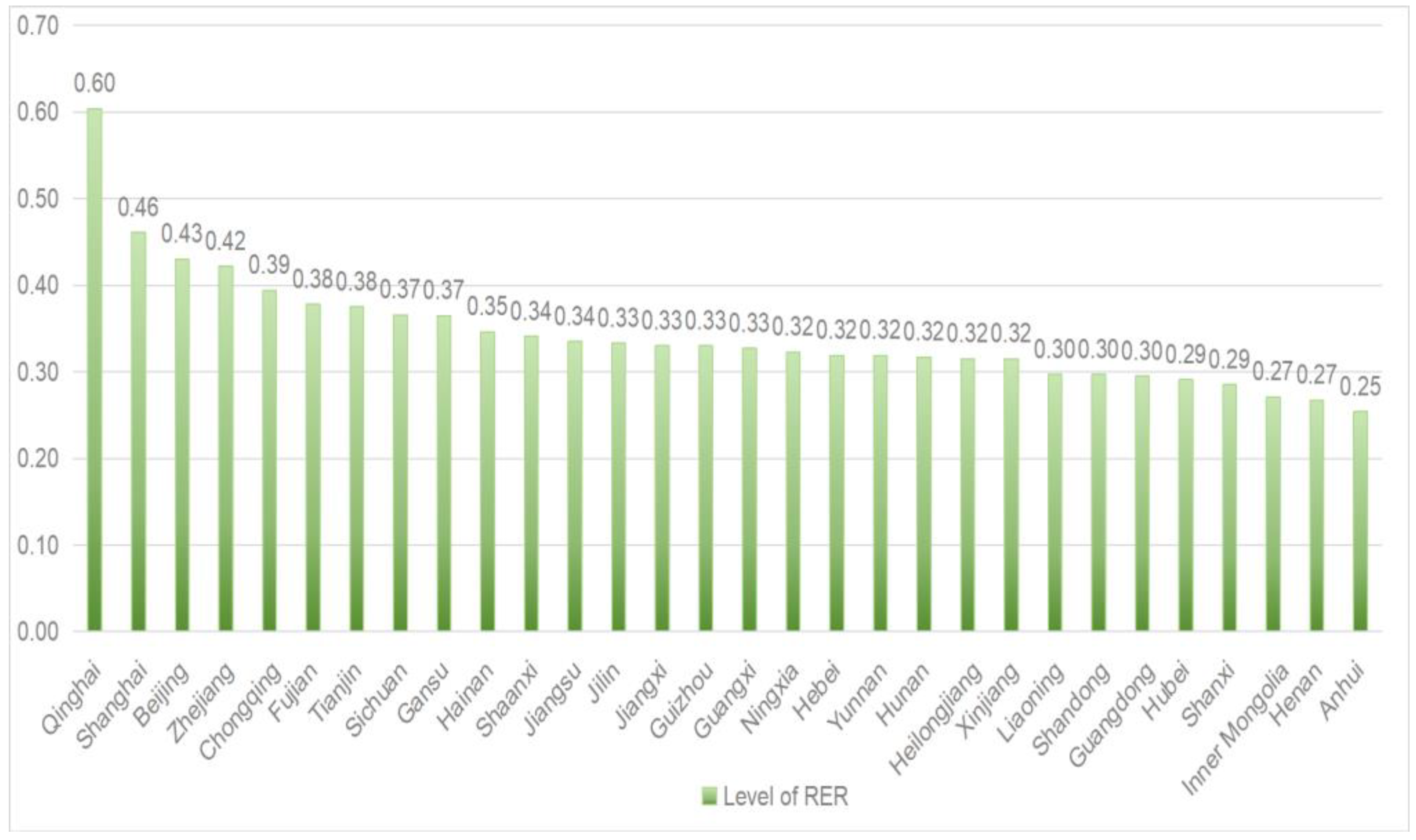
4.2.1. Evaluation of RER Levels by Province

The evaluation results after applying the entropy weight TOPSIS method to the data are presented in Table 2. Figure 2 also illustrates each province’s composite scores (Ci) and ranking for the overall RER level score. Among the provinces, Qinghai, Shanghai, Beijing, Zhejiang, and Chongqing have been identified as having a higher overall rural ecological revitalization level. It indicates that these provinces have made significant progress in this area. However, only Qinghai Province’s overall rural ecological revitalization level has reached more than 0.6, while the rest of the provinces still have much room for improvement.
The natural breakpoint method is effective at reflecting the differences between datasets and has been widely used for previous evaluation studies [82,83]. Thus, this study employs this method to classify the composite scores of provincial RER levels into three categories: “high” (≥0.394), “medium” (0.315 to 0.393), and “low” (≤0.314) (Figure 3). Regarding the provincial RER levels across the country, more than half of the provinces have reached “medium” RER levels (including provinces of Fujian, Tianjin, Sichuan, Gansu, Hainan, Shaanxi, Jiangsu, Jilin, Jiangxi, Guizhou, Guangxi, Ningxia, Hebei, Yunnan, Hunan, Heilongjiang). Five provinces (Qinghai, Shanghai, Beijing, Zhejiang, and Chongqing) are categorized as having “high” RER levels. Nine provinces (Xinjiang, Liaoning, Shandong, Guangdong, Hubei, Shanxi, Inner Mongolia, Henan, and Anhui) are categorized as having “low” RER levels.

4.2.2. Evaluation of RER Levels by Subsystem

This study also calculated each subsystem of RER levels across the 30 provinces (Table 3). Figure 4 shows heat maps based on each subsystem’s RER levels in the nation. For the driver subsystem, Zhejiang, Shanghai, Beijing, Hebei, Jiangsu, and Tianjin have relatively higher rankings, with scores larger than 0.48 (Table 3; Figure 4A). More than half of the provinces in this subsystem scored below 0.35 (Table 3; Figure 4A), indicating that there is still much room for improvement. The pressure subsystem mainly measures the impact of rural production and residents’ lives on rural ecology. Qinghai, Jilin, Gansu, and Shaanxi ranked better in this study, with scores larger than 0.7 (Table 3; Figure 4B), indicating that the pressure for rural ecological revitalization in these provinces is relatively low. Most other provinces presented medium pressure, with scores ranging from 0.58 to 0.66 (Table 3). For the state subsystem, Qinghai is the only province with a score of 0.8 (Table 3; Figure 4C). This is because Qinghai has the largest nature reserve in China. Although the remaining provinces scored below 0.4 (Table 3; Figure 4C), Gansu and Heilongjiang ranked higher than others. For the impact subsystem, Qinghai and Chongqing have relatively high scores of about 0.8, while most provinces are at a medium level with scores ranging from 0.55 to 0.69 (Table 3; Figure 4D). In terms of the response subsystem, Beijing, Shanghai, Zhejiang, Chongqing, Tianjin, and Fujian exhibit high levels with scores larger than 0.53 (Table 3; Figure 4E). In contrast, the remaining provinces display low levels of response, with more than half of the provinces exhibiting response levels below 0.38 (Table 3; Figure 4E).

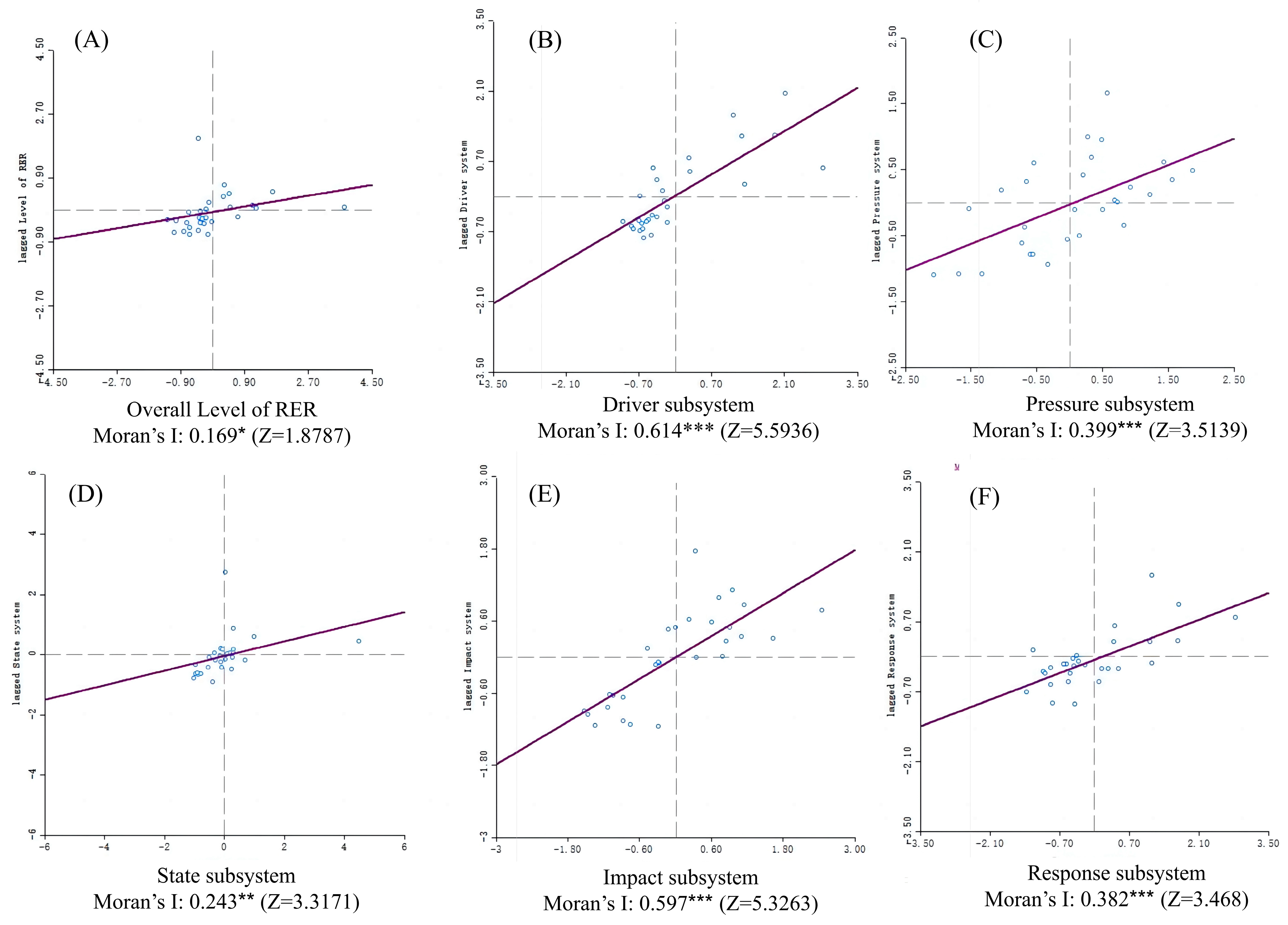
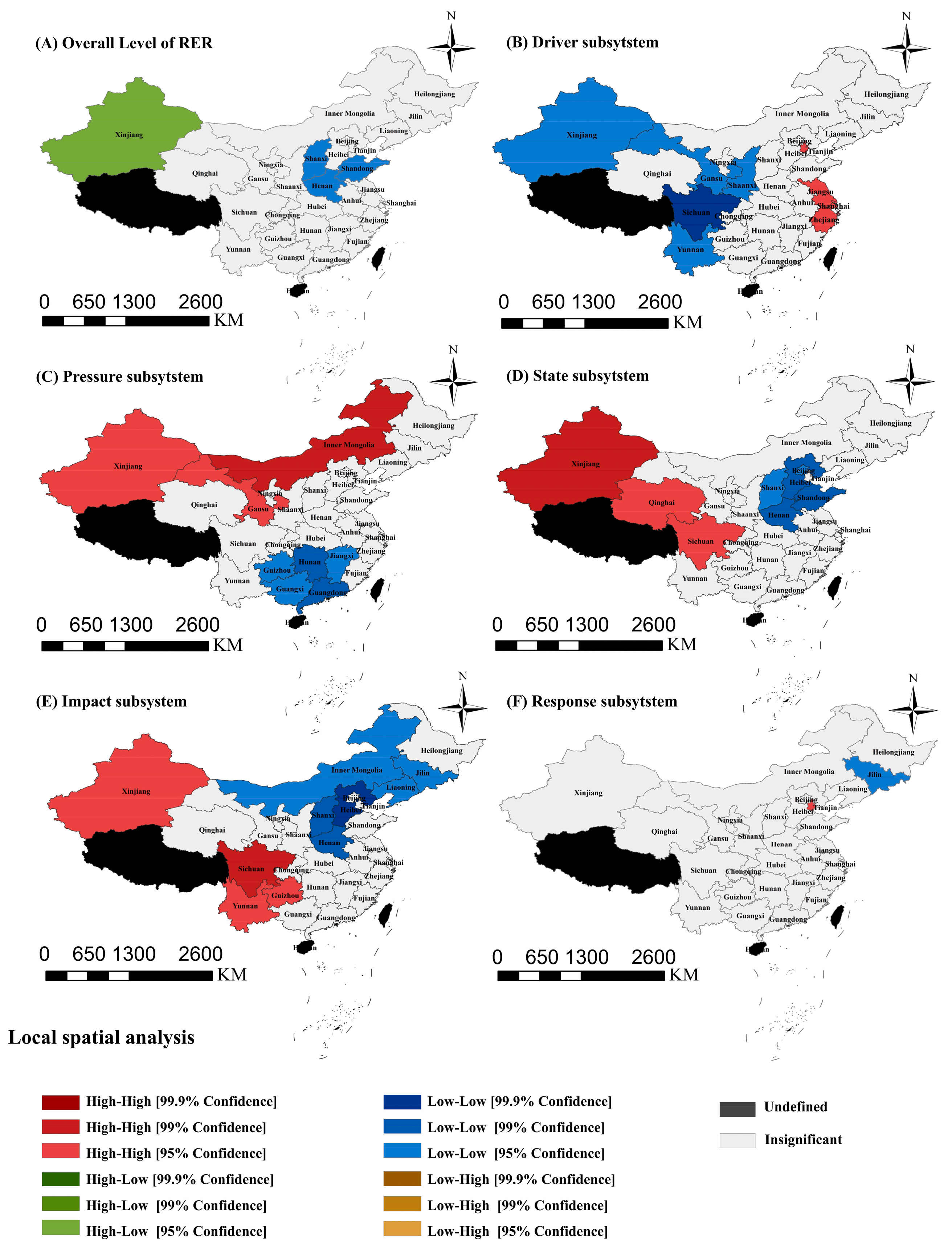
4.3. Spatial Autocorrelation Analysis of RER Levels

From the above entropy-based TOPSIS evaluation results of RER levels (Table 2 and Table 3; Figure 3 and Figure 4), it can be seen that there seems to be spatial aggregation effects on the RER levels in the overall system and subsystems. For instance, the Beijing–Tianjin–Hebei region and the Yangtze River Delta region demonstrate higher levels of aggregation across different RER subsystems. This trend is consistent with the findings of Long [84], who conducted a comprehensive assessment of the quality of economic growth, environmental sustainability, and social welfare for 31 provinces. The impact subsystem also revealed that Southwest China generally achieved higher scores, which is in line with Wang et al.’s [85] findings about the environmental carrying capacity of the Yangtze River. To gain a deeper understanding of the geographical patterns of RER development levels, this study conducted a spatial autocorrelation analysis.
The geospatial autocorrelation analyses were performed on both global and local dimensions. Figure 5 depicts the results of global geospatial autocorrelation analysis for 30 provinces. All Moran’s I values were statistically significant regardless of the overall RER level or each subsystem’s RER levels (Figure 5). The overall Moran’s I index for the RER level is 0.169, indicating that a positive geospatial correlation exists in terms of the overall level of RER. The results also show positive autocorrelations across all subsystems. The strongest effect was observed in the driver subsystem (0.614), followed by the impact subsystem (0.597), pressure subsystem (0.399), response subsystem (0.382), and state subsystem (0.243). The positive geospatial autocorrelations indicate that all RER subsystems present geological aggregations that provinces with higher levels of RER tend to cluster together.
In order to more accurately assess the degree of RER’s spatial aggregation between neighboring provinces, this study employs a local Moran’s I index (Figure 6), which encompasses four forms: high–high aggregation, low–low aggregation, high–low aggregation, and low–high aggregation [86]. In terms of the overall RER level, Xinjiang exhibits low–high aggregation with surrounding provinces at the 95% confidence interval (Figure 6A). Additionally, Shanxi, Henan, and Shandong provinces demonstrate a low–low aggregation at the 95% confidence interval, indicating that the overall level of rural ecological revitalization in that region is relatively low (Figure 6A). In the driver subsystem, the central and western regions (including Xinjiang, Gansu, Shanxi, Chongqing, and Yunnan) exhibit low–low aggregation, whereas Beijing, Jiangsu, Shanghai, and Zhejiang demonstrate high–high aggregation (Figure 6B). This suggests that the driving force of RER exhibits an obvious geographical spatial pattern of high in the east and low in the west. In the pressure subsystem, the central and western regions (including Inner Mongolia, Xinjiang, and Qinghai) exhibit a high–high clustering pattern, while the southern regions (Hunan, Jiangxi, Guangdong, Guangxi, and Guizhou) demonstrate low–low aggregation (Figure 6C). A trend in high in the north and low in the south is captured. In the results of the state subsystem, the northwestern region (Xinjiang, Qinghai, and Sichuan) displays an optimal ecological state cluster (a high–high pattern) (Figure 6D). In contrast, the Huang–Huai–Hai Plain region (Hebei, Shandong, Henan, and Tianjin) generally demonstrates a low ecological state cluster (a low–low pattern) (Figure 6D). In the impact subsystem, Xinjiang, Yunnan, and Sichuan form a high–high aggregation, while Inner Mongolia, Jilin, Liaoning, Shanxi, and Hebei have a low–low aggregation (Figure 6E). In the results of the response subsystem, Tianjin exhibits a high–high aggregation, while Jilin exhibits a low–low aggregation (Figure 6F).

5. Discussion

5.1. Weighted Evaluation Indicators and Their Reasons

The assessment of RER levels serves as the foundation for China’s rural revitalization strategy. It is, thus, imperative to develop an assessment framework for rural ecosystems, one that would allow for the measurement of the performance of ecological policy governance. Despite the importance ascribed to rural revitalization as a future development undertaking in China, the indicator system for evaluating the level of rural ecological revitalization remains in its infancy, and the development status of provinces and municipalities remains unclear. Accordingly, this study employs the DPSIR framework and establishes an evaluation system comprising 5 primary indicators, 12 secondary indicators, and 33 tertiary indicators. Subsequently, the indicators were assigned weights, and the provinces and cities were ranked accordingly. However, considerable discrepancies were observed in the assigned weights between systems and subsystems, as well as between the inter-indicators. Consequently, a detailed examination and clarification of these disparate weightings will be provided in this discussion.
In the driver subsystem, the per capita disposable income of rural residents (0.04732) and the urbanization rate of the resident population (0.02892) vary noticeably among the 30 provinces. The income structure of rural residents in the eastern region is more diversified and has a good foundation in agricultural product processing, electronic manufacturing, and rural cultural tourism [87]. Therefore, the per capita disposable income in the eastern region is higher than in the central and western regions. The differences in urbanization rates between provinces are due to the differences in the urbanization process between the eastern and western regions of China, as well as differences in economic development levels, scientific and technological investment, and government efficiency [88].
In the pressure subsystem, ammonia nitrogen emissions from agricultural sources (0.02446) and inland aquaculture intensity (0.02371) are the two leading indicators. The specific reasons for the large differences in agricultural ammonia emissions between provinces may be due to differences in soil types, nitrogen fertilizer inputs, farming systems, and climate conditions [89]. At the same time, differences in inland aquaculture intensity are related to the regional distribution of water resources, inter-regional aquaculture technology levels, policies, and local market consumption demand [90].
In the state subsystem, the percentage of area in nature reserves (0.11731) exhibits noticeable differences among the 30 provinces and, therefore, has the highest weight. Establishing nature reserves, to a certain extent, means sacrificing development opportunities. However, it effectively builds China’s ecological security and bears the ecological pressure of rapid urban development [91]. In addition, nature reserves have played an instrumental role in reducing regional poverty and fostering socioeconomic development [92]. In rural ecological revitalization, nature reserves are regarded as an essential resource for promoting rural economic development. The rise of rural cultural tourism and national park projects has brought more ecological well-being and economic development potential to rural residents [93]. Therefore, higher weights are conducive to incentivizing local governments to enhance the sustainable development of rural ecosystems. In addition, water resources per capita (0.1042) is another leading indicator in the state subsystem that is not supervised. According to the World Resources Institute [94], China has medium to high water risks, and the geological distribution of water resources is highly uneven. The North China region (north of the Yangtze River Basin) accounts for 63.5% of the country’s land area but only 19% of the country’s water resources [95]. Access to water resources is crucial for human life and production. The availability and use of water have profound implications for regional development, human well-being, and social equity [96]. To this end, the Chinese government has launched the South-to-North Water Diversion Project, scheduled to be completed in 2050, to improve the imbalance of water resources between regions [97].
In the impact subsystem, most indicators present similar weights (around 0.02). The only indicator with a smaller weight is the amount of agricultural mulch film used per unit (0.00861). This indicates that the farmers’ production practices regarding agricultural film use do not differ substantially. In China, agricultural film mulching has become a commonly used cultivation technique for increasing crop yield [18]. On average, 2 million tons of plastic film are used for agricultural production every year in China [98]. Therefore, it is urgent to promote the use of biodegradable agricultural films and increase the recycling rate of agricultural films [99].
The weights of most indicators in the response subsystem are higher than those in other subsystems. This indicates substantial differences exist in the response subsystem among the 30 provinces. Specifically, the rural domestic sewage treatment rate (0.07644) and comprehensive livestock and poultry manure utilization rate (0.05458) have a higher weight, indicating that these two indicators vary greatly. Although rural domestic sewage treatment has been identified as a priority of the Habitat Improvement Action, due to regional differences in sanitation conditions, investment, and policy implementation efficiency, there are significant variations in the extent of rural domestic sewage treatment coverage [100]. Therefore, it is necessary to continue to promote sewage treatment coverage to enhance rural residents’ comprehensive well-being [101]. The observed differences in integrated livestock waste utilization rate may be due to differences in animal types, livestock production seasons, production modes, pollution coefficients, and policy incentives [102].

5.2. Distinguished Provincial RER Levels

As the national strategy of rural revitalization started in 2018, a series of rural habitat improvement measures have been implemented, and the rural ecological environment has been governed and improved. However, because rural ecology is a complex system, the ecological governance measures have not yet fully improved the overall level of rural ecology across the country [46,103].
The RER strategy, as a systematic ecological governance policy, necessitates the implementation of targeted policies across various dimensions, including policy-driven, ecological conservation, productive environment, human habitat, and environmental restoration [52,53]. To effectively enhance the priorities within each of these areas, it is essential to study the provincial differences in the various subsystems of RER.
For the driver subsystem, the Beijing–Tianjin–Hebei and Yangtze River Delta regions tend to exhibit higher scores. In contrast, the western regions generally perform not very desirable (Figure 4A). This may be due to the generally superior economic development of the provinces, as well as the overall economic development and ecological environment having reached a more optimal equilibrium. The remaining provinces exhibit an imbalance between economic development and ecological revitalization.
For the pressure subsystem, with regard to the spatial distribution of the provinces, those with relatively high scores are concentrated in the northwestern and northeastern regions (Figure 4B). This may be because these agricultural regions have a wider production area, and the overall intensity of agricultural production is lower [84,104].
For the state subsystem, the results indicate that the provinces of Qinghai, Gansu, and Heilongjiang exhibit a higher level of performance than other provinces. Qinghai has prioritized ecological and environmental protection as a cornerstone of regional development, implementing a range of policies to foster the growth of a robust ecological province [105]. Gansu has established a substantial forested area within the Western Qinling-Minshan mountains, which serves as an essential water source and is designated as a “Biodiversity Hotspot” in south-central China [106]. The province encompasses over 60 nature reserves, representing a significant commitment to biodiversity conservation [107]. In Heilongjiang province, 29 ecological functional zones with biodiversity conservation functions have been established in the Da and Xiao Xing’anling Mountains and Changbai Mountains [108]. A series of ecological protection and restoration measures have been implemented in these areas, effectively improving the functions of the ecosystem.
For the impact subsystem, the Northeast and North China regions have relatively low scores. Agricultural production in the northern regions has less impact on ecology, probably because unit production intensity is lower (shorter growing seasons), but the total amount of cultivated land is much larger than in southern regions. Similarly, from a perspective of coupling and coordination of agricultural production and agroecology, Y. Liu et al. [109] found that the degree of coupling and coordination in northern production areas is generally higher than that in southern production areas.
For the response subsystem, the provincial RER score may be related to the level of economic development of each region. Regions with faster economic development are likely to invest more in ecological restoration to enhance the overall ecological environment. Conversely, less economically developed regions are more likely to invest in economic development, which may result in further discrepancies in the response subsystem.

5.3. Strong Spatial Autocorrelations

The global spatial autocorrelation analysis revealed that each system exhibited significant spatial dependence, indicating that not only are different systems influenced by internal factors but also by neighboring regions. This finding is consistent with Yang et al. [18] conclusion. This suggests that the overall improvement of the RER system requires prioritizing appropriate policies based on the spatial autocorrelations of different subsystems. In this study, the driver subsystem is the most spatially correlated. Provinces with higher levels of RER driving force are concentrated in the southeastern region, including the most urbanized provinces, such as Beijing, Shanghai, Hebei, Jiangsu, and Zhejiang. Li [109] argued that the driving force of rural development is related to the level of urbanization, but it may have a negative impact on rural ecological systems. Therefore, it is necessary to ensure that urban development can continue to provide momentum for rural development while limiting the negative impacts caused by urban development during the policy design and implementation. This is consistent with the policy recommendations on urban-rural development in the context of the digital economy put forth by Tao [110]. It is vital to strengthen environmental protection and mitigate the environmental impact of regional development [18]. Additionally, given the significant autocorrelations in all subsystems, the government should prioritize implementing joint environmental policies across provinces.
For the local spatial autocorrelation analysis, h–high aggregation indicates that the levels of the neighboring provinces are all high and positively correlated [111]. The high–high region represents a region with a high degree of optimization and reflects a spatial diffusion effect [112]. For implications, while these clustered regions can maintain their high levels, their development experience should be promoted as demonstration sites for specific RER subsystems (such as the Yangtze Delta region for driving forces development, northwest region for pressure reduction, western region for state improvement, and southwest region for impact building). Conversely, low–low aggregation signifies that the levels of the neighboring provinces are all low and positively correlated. These low–low regions are the weakest spots (such as the Shandong–Shanxi–Henan region) hindering the RER development levels in the nation. Therefore, it is imperative to prioritize these regions and consider developing supportive ecological policies. In addition, high–low (or low–high) aggregation indicates that the levels of adjacent provinces are negatively correlated, and the province with low (high) levels is clustered with high (low) level provinces. In the high–low region (i.e., Xinjiang), there are considerable regional disparities, reflecting the polarized nature of regional development. Although the region’s own RER level is high, there is a lack of spillover effects to surrounding provinces. It is suggested to formulate cross-regional coordinated development policies to allow high-level provinces to drive surrounding low-level provinces.

5.4. Policy Suggestion

China has made significant strides in the field of ecological revitalization. In the context of rural revitalization, the environment has undergone remarkable enhancement, leading to a progressively improved quality of life for rural communities. However, due to the relatively unbalanced rural development, there are large differences in the development levels of RER among different provinces and regions. To further boost the overall RER level in China, it is decisive to identify policy priority targets, weak links in specific regional development, and spatial aggregation and spillover effects. This will help optimize policy resource allocation. Based on the results of this study, the following policy recommendations are provided.
  • From the perspective of indicator weighting, it is imperative to implement more targeted policies for the rural ecological state subsystem and the response subsystem. Firstly, it is necessary to continue to carry out rural living environment improvement actions and promote the effective strengthening of rural sewage treatment, garbage disposal, and other work. At the same time, a long-term supervision and assessment mechanism needs to be established to ensure that all measures achieve actual results. In addition, adhere to ecological restoration projects, further promote long-term governance mechanisms, establish comprehensive ecological restoration measures, and enhance comprehensive ecological management capabilities. Lastly, strengthen the protection of nature reserves, give full play to their ecological and economic value, and promote the overall improvement of the rural ecological environment.
  • Based on the provincial RER subsystem levels and rankings, it is evident that each province should develop specific policies or initiatives tailored to the unique characteristics of their respective RER subsystems. Given the substantial disparities in overall RER and subsystem scores across regions, relevant authorities must reallocate policy resources according to the ecological deficiencies within their rural areas and adopt more modern technologies and collaborative management networks to improve their RER levels significantly.
  • The spatial correlation results underscore the necessity for coordinated governance across regions to achieve comprehensive improvements in RER levels, with different regional clustering types corresponding to distinct governance models. However, to attain coordinated governance of the ecological environment, it is imperative to further clarify the rights and responsibilities of diverse governmental and non-governmental entities. Additionally, establishing a cross-province ecological governance cooperation mechanism and formulating unified, comprehensive ecological monitoring indicators are equally crucial.

6. Conclusions and Limitations

6.1. Conclusions

This study responded to the calls for a systematic evaluation tool to assess and monitor the nationwide RER levels [46,113]. This study has made several contributions to the literature.
  • Based on a robust theoretical framework (DPSIR), this study developed an evaluation system with five subsystems, twelve secondary indicators, and thirty-three tertiary indicators. Unlike previous studies that focused on ecological achievements, the evaluation tool of this study presents a complex, multi-attribute, and multi-level system, which helps to comprehensively measure the RER development level in specific dimensions.
  • By employing the entropy weight method, this study managed to objectively determine the weights of each indicator based on a national dataset and established the validity of the index system for evaluation works. The developed evaluation index system can be used for future long-term evaluation and yearly monitoring of RER development at the national and provincial levels.
  • This study used the TOPSIS method based on Euclidean distance to generate composite evaluation scores for the overall and subsystem RER levels of each province. Those scores and ranking information can be an effective diagnosis tool to identify strengths and weaknesses of RER development in each province. Then, the development strategies and priorities can be adjusted accordingly. More adaptive policies and public resources can be more efficiently allocated to increase the overall RER levels.
  • This study revealed the geospatial autocorrelation of RER levels on global and local dimensions. On the global dimension, both overall RER levels and individual subsystems’ RER levels have positive geospatial autocorrelations. This represents a tendency for nearby provinces to exhibit relatively similar RER levels. This trend is also confirmed by the low–low and high–high patterns of autocorrelations in the local dimensions. Given that geospatial aggregations frequently exist across different subsystems, it is recommended that hot spots (high–high areas) establish demonstration sites to expand the positive driving role; cold spots (low–low areas) need more attention and supportive policies to remove obstacles to improving RER levels.

6.2. Limitation and Prospect

Even though this study developed a comprehensive index system that evaluates RER development, empirically assessed 30 provinces’ RER levels, and explored the spatial pattern of RER development, this study still bears some limitations. This study did not recognize the temporal evolution of RER development levels, mainly due to data availability. The data we used are from 2020, which were released in 2021. This is also the first year of the country’s latest 14th Five-Year Plan (2021–2025). For this reason, most 2021 yearbooks and statistics reports published used 2020 data as the benchmark for the 14th Five-Year Plan. However, the following year’s data reporting is not as comprehensive as 2021. Given that our index system contains 33 tertiary indicators, the following year’s data were insufficient to assess RER levels’ temporal change longitudinally. Nevertheless, it is recommended to conduct comparative studies after data are available at the end of the 14th Five-Year Plan. In addition, this study did not explore the causal relationships between subsystems of RER. This is because the DPSIR model’s causal paths have been adequately tested by scholars [50,114,115]. A dynamic feedback mechanism (D→P→S→I; R→D; R→S; R→I; R→P) has been commonly tested and verified in the literature [50,114]. Therefore, given the richness of such research findings, it was not the scope of this study to test these causal relationships.

Author Contributions

G.H.: Conceptualization, formal analysis, funding acquisition, project administration, supervision, writing—original draft, writing—review and editing. Z.W.: Conceptualization, data curation, formal analysis, writing—original draft, validation, visualization. H.Z.: Conceptualization, methodology. L.Z.: funding acquisition, project administration, supervision. All authors have read and agreed to the published version of the manuscript.

Funding

This work was supported by the National Natural Science Foundation of China (NSFC), grant number 72303101; Jiangsu Province Department of Education General Projects of Philosophy and Social Science Research in Colleges and Universities, grant number: 2023SJYB0057; Nanjing Agricultural University Humanities and Social Science Fund, grant number SKYC2023008.

Data Availability Statement

The data presented in this study are available at the request of the corresponding author due to governmental data restrictions.

Conflicts of Interest

The authors declare that they have no conflict of interest.

References

  1. Li, Y.; Westlund, H.; Zheng, X.; Liu, Y. Bottom-up initiatives and revival in the face of rural decline: Case studies from China and Sweden. J. Rural Stud. 2016, 47, 506–513. [Google Scholar] [CrossRef]
  2. The World Bank. World Bank Open Data. Available online: https://data.worldbank.org (accessed on 24 May 2024).
  3. FAO. FAO Framework on Rural Extreme Poverty. Towards Reaching Target 1.1 of the Sustainable Development Goals|Policy Support and Governance|Food and Agriculture Organization of the United Nations. Available online: https://www.fao.org/policy-support/tools-and-publications/resources-details/en/c/1201664/ (accessed on 24 May 2024).
  4. Augère-Granier, M.L.; McEldowney, J. EU Rural Development Policy Impact, Challenges and Outlook; European Parliamentary Research Service: Brussels, Belgium, 2021. [Google Scholar]
  5. Berkhout, P.; Hart, K.; Kuhmonen, T. EU Rural Development Policies: Present and Future. In EU Bioeconomy Economics and Policies: Volume II; Dries, L., Heijman, W., Jongeneel, R., Purnhagen, K., Wesseler, J., Eds.; Palgrave Advances in Bioeconomy: Economics and Policies; Springer International Publishing: Cham, Switzerland, 2019; pp. 213–241. ISBN 978-3-030-28641-5. [Google Scholar]
  6. Cohen, S.A.; Greaney, M.L. Aging in Rural Communities. Curr. Epidemiol. Rep. 2022, 10, 1–16. [Google Scholar] [CrossRef]
  7. McIntyre, A.C.; Cody, S.L.; Ezemenaka, C.J.; Johnson, K.; Mugoya, G.; Foster, P. HIV Knowledge, Risk Factors, and Utilization of Services in the US Rural Deep South. J. Racial Ethn. Health Disparities 2023, 1–9. [Google Scholar] [CrossRef] [PubMed]
  8. Li, S.; Congmou, Z.; Li, Y.; Dong, B.; Tan, K.; Deng, X. Agricultural space function transitions in rapidly urbanizing areas and their impacts on habitat quality: An urban–Rural gradient study. Environ. Impact Assess. Rev. 2023, 99, 107019. [Google Scholar] [CrossRef]
  9. Préau, C.; Tournebize, J.; Lenormand, M.; Alleaume, S.; Boussada, V.G.; Luque, S. Habitat connectivity in agricultural landscapes improving multi-functionality of constructed wetlands as nature-based solutions. Ecol. Eng. 2022, 182, 106725. [Google Scholar] [CrossRef]
  10. Qu, Y.; Zhang, Q.; Zhan, L.; Jiang, G.; Si, H. Understanding the nonpoint source pollution loads’ spatiotemporal dynamic response to intensive land use in rural China. J. Environ. Manag. 2022, 315, 115066. [Google Scholar] [CrossRef] [PubMed]
  11. Zhao, S.; Liu, S.; Hou, X.; Sun, Y.; Beazley, R. Air pollution and cause-specific mortality: A comparative study of urban and rural areas in China. Chemosphere 2021, 262, 127884. [Google Scholar] [CrossRef] [PubMed]
  12. Song, M.; Hu, C.; Yuan, J.; Zhang, A.; Liu, X. Toward an ecological civilization: Exploring changes in China’s land use policy over the past 35 years using text mining. J. Clean. Prod. 2023, 427, 139265. [Google Scholar] [CrossRef]
  13. CAP at a Glance—European Commission. Available online: https://agriculture.ec.europa.eu/common-agricultural-policy/cap-overview/cap-glance_en (accessed on 22 July 2024).
  14. Jaeger, J.; McLaughlin, K.; Neuberger, J.; Dellesky, C. Does Biden’s American Jobs Plan Stack Up on Climate and Jobs? World Resources Institute: Washington, DC, USA, 2021. [Google Scholar]
  15. Saha, D.; Rudee, A.; Leslie-Bole, H.; Cyrs, T. The Economic Benefits of the New Climate Economy in Rural America; World Resources Institute: Washington, DC, USA, 2021. [Google Scholar]
  16. Cabinet Office. Current Condition and Future Development of Regional Revitalisation; Cabinet Office: London, UK, 2019. [Google Scholar]
  17. Dilley, L.; Gkartzios, M.; Odagiri, T. Developing counterurbanisation: Making sense of rural mobility and governance in Japan. Habitat Int. 2022, 125, 102595. [Google Scholar] [CrossRef]
  18. Yang, G.; Gui, Q.; Liu, J.; Chen, X.; Cheng, S. Spatial-temporal evolution and driving factors of ecological security in China based on DPSIR-DEA model: A case study of the Three Gorges reservoir area. Ecol. Indic. 2023, 154, 110777. [Google Scholar] [CrossRef]
  19. Wang, Y.; Zhao, N.; Chen, K.; Wu, C. Intensification of compound temperature extremes by rapid urbanization under static and dynamic Urban-rural division: A comparative case study in Hunan Province, Central-South China. Sci. Total Environ. 2024, 908, 168325. [Google Scholar] [CrossRef] [PubMed]
  20. Wu, K.; Wang, D.; Lu, H.; Liu, G. Temporal and spatial heterogeneity of land use, urbanization, and ecosystem service value in China: A national-scale analysis. J. Clean. Prod. 2023, 418, 137911. [Google Scholar] [CrossRef]
  21. Yu, P.; Zhang, S.; Yung, E.H.K.; Chan, E.H.W.; Luan, B.; Chen, Y. On the urban compactness to ecosystem services in a rapidly urbanising metropolitan area: Highlighting scale effects and spatial non–stationary. Environ. Impact Assess. Rev. 2023, 98, 106975. [Google Scholar] [CrossRef]
  22. Rogers, S.; Wang, Z.J.-H.; He, J. Farmers’ practices and the political ecology of agrochemicals in rural China. Geoforum 2023, 141, 103751. [Google Scholar] [CrossRef]
  23. Yin, Q.; Sui, X.; Ye, B.; Zhou, Y.; Li, C.; Zou, M.; Zhou, S. What role does land consolidation play in the multi-dimensional rural revitalization in China? A research synthesis. Land Use Policy 2022, 120, 106261. [Google Scholar] [CrossRef]
  24. He, S.; Zhang, Y. Reconceptualising the rural through planetary thinking: A field experiment of sustainable approaches to rural revitalisation in China. J. Rural Stud. 2022, 96, 42–52. [Google Scholar] [CrossRef]
  25. Yu, L.; Wang, Y.; Li, M. The emergence of counter-urbanisation in China: Can it be a pathway for rural revitalisation? Habitat Int. 2024, 144, 102998. [Google Scholar] [CrossRef]
  26. Hansen, M.H.; Li, H.; Svarverud, R. Ecological civilization: Interpreting the Chinese past, projecting the global future. Glob. Environ. Change 2018, 53, 195–203. [Google Scholar] [CrossRef]
  27. Geng, Q.; Lo, K. Global ecological civilization: An analysis of macro-level policies of the Belt and Road Initiative. Res. Glob. 2023, 7, 100141. [Google Scholar] [CrossRef]
  28. Wei, F.; Cui, S.; Liu, N.; Chang, J.; Ping, X.; Ma, T.; Xu, J.; Swaisgood, R.R.; Locke, H. Ecological civilization: China’s effort to build a shared future for all life on Earth. Natl. Sci. Rev. 2021, 8, nwaa279. [Google Scholar] [CrossRef]
  29. Liu, Y. Introduction to land use and rural sustainability in China. Land Use Policy 2018, 74, 1–4. [Google Scholar] [CrossRef]
  30. Yang, Y.; Hu, N. The spatial and temporal evolution of coordinated ecological and socioeconomic development in the provinces along the Silk Road Economic Belt in China. Sustain. Cities Soc. 2019, 47, 101466. [Google Scholar] [CrossRef]
  31. Zhu, C.; Lin, Y.; Zhang, J.; Gan, M.; Xu, H.; Li, W.; Yuan, S.; Wang, K. Exploring the relationship between rural transition and agricultural eco-environment using a coupling analysis: A case study of Zhejiang Province, China. Ecol. Indic. 2021, 127, 107733. [Google Scholar] [CrossRef]
  32. Ye, X.; Chuai, X. Have rural settlement changes harmed ecosystem carbon in China? Appl. Geogr. 2023, 153, 102917. [Google Scholar] [CrossRef]
  33. Wang, Y.; Zhu, Y. Exploring the effects of rural human settlement on rural development: Evidence from Xianju County in Zhejiang Province, China. Environ. Dev. 2023, 46, 100845. [Google Scholar] [CrossRef]
  34. Huang, A.; Liu, B.; Zhang, A.; Zhan, J. Coordinated development of rural habitat in China: A study of measurement, spatio-temporal evolution and convergence. J. Clean. Prod. 2023, 398, 136651. [Google Scholar] [CrossRef]
  35. Zhang, R.; Yuan, Y.; Li, H.; Hu, X. Improving the framework for analyzing community resilience to understand rural revitalization pathways in China. J. Rural Stud. 2022, 94, 287–294. [Google Scholar] [CrossRef]
  36. Guo, Y.; Chen, P.; Zhu, Y.; Zhang, H. Study on comprehensive evaluation of human settlements quality in Qinghai Province, China. Ecol. Indic. 2023, 154, 110520. [Google Scholar] [CrossRef]
  37. Li, X.; Lei, L. Evaluating rural sustainable land use from a system perspective based on the ecosystem service value. Reg. Sustain. 2023, 4, 96–114. [Google Scholar] [CrossRef]
  38. Montalvo-Navarrete, J.M.; Lasso-Palacios, A.P. Energy access sustainability criteria definition for Colombian rural areas. Renew. Sustain. Energy Rev. 2024, 189, 113922. [Google Scholar] [CrossRef]
  39. Gainsbury, A.M.; Santos, E.G.; Wiederhecker, H. Does urbanization impact terrestrial vertebrate ectotherms across a biodiversity hotspot? Sci. Total Environ. 2022, 835, 155446. [Google Scholar] [CrossRef] [PubMed]
  40. Renard, D.; Rhemtulla, J.M.; Bennett, E.M. Historical dynamics in ecosystem service bundles. Proc. Natl. Acad. Sci. USA 2015, 112, 13411–13416. [Google Scholar] [CrossRef] [PubMed]
  41. Zhou, J.; Liu, X.; Liu, X.; Wang, W.; Wang, L. Assessing agricultural non-point source pollution loads in typical basins of upper Yellow River by incorporating critical impacting factors. Process Saf. Environ. Prot. 2023, 177, 17–28. [Google Scholar] [CrossRef]
  42. Liu, R.; Zhang, L.; Tang, Y.; Jiang, Y. Understanding and evaluating the resilience of rural human settlements with a social-ecological system framework: The case of Chongqing Municipality, China. Land Use Policy 2024, 136, 106966. [Google Scholar] [CrossRef]
  43. Sun, X.; Chu, D.; Li, Q.; Shi, Y.; Lu, L.; Bi, A. Dynamic successive assessment of Rural Human Settlements Environment in China. Ecol. Indic. 2023, 157, 111177. [Google Scholar] [CrossRef]
  44. Wang, D.; Li, Y.; Yang, X.; Zhang, Z.; Gao, S.; Zhou, Q.; Zhuo, Y.; Wen, X.; Guo, Z. Evaluating urban ecological civilization and its obstacle factors based on integrated model of PSR-EVW-TOPSIS: A case study of 13 cities in Jiangsu Province, China. Ecol. Indic. 2021, 133, 108431. [Google Scholar] [CrossRef]
  45. Zhang, L.; Yang, J.; Li, D.; Liu, H.; Xie, Y.; Song, T.; Luo, S. Evaluation of the ecological civilization index of China based on the double benchmark progressive method. J. Clean. Prod. 2019, 222, 511–519. [Google Scholar] [CrossRef]
  46. Yusheng, K.; Ntarmah, A.H. Developing a rural ecological assessment index for Jiangsu Province, China. J. Nat. Conserv. 2021, 64, 126093. [Google Scholar] [CrossRef]
  47. Augusiak, J.; Van Den Brink, P.J.; Grimm, V. Merging validation and evaluation of ecological models to ‘evaludation’: A review of terminology and a practical approach. Ecol. Model. 2014, 280, 117–128. [Google Scholar] [CrossRef]
  48. Meng, F.; Guo, J.; Guo, Z.; Lee, J.C.K.; Liu, G.; Wang, N. Urban ecological transition: The practice of ecological civilization construction in China. Sci. Total Environ. 2021, 755, 142633. [Google Scholar] [CrossRef]
  49. Hu, X.; Ma, C.; Huang, P.; Guo, X. Ecological vulnerability assessment based on AHP-PSR method and analysis of its single parameter sensitivity and spatial autocorrelation for ecological protection—A case of Weifang City, China. Ecol. Indic. 2021, 125, 107464. [Google Scholar] [CrossRef]
  50. Chen, H.; Xu, J.; Zhang, K.; Guo, S.; Lv, X.; Mu, X.; Yang, L.; Song, Y.; Hu, X.; Ma, Y.; et al. New insights into the DPSIR model: Revealing the dynamic feedback mechanism and efficiency of ecological civilization construction in China. J. Clean. Prod. 2022, 348, 131377. [Google Scholar] [CrossRef]
  51. Čustović, H.; Kovačević, Z.; Tvica, M. Rural Ecology; University of Sarajevo: Sarajevo, Bosnia and Herzegovina, 2013; ISBN 978-9958-597-35-0. [Google Scholar]
  52. Cao, L.; Xu, X. Rural Ecological Revitalization: Overall Objectives, Key Tasks and Promotion Countermeasures. Adm. Reform 2022, 11, 14–22. (In Chinese) [Google Scholar] [CrossRef]
  53. Bao, X. Rural Ecological Revitalization: Overall Objectives, Key Tasks and Promotion Countermeasures. Huxiang Forum Chin. 2023, 36, 45–55. [Google Scholar] [CrossRef]
  54. Nie, X.; Li, X.; Lyu, C.; Su, Y.; Wang, H. Can ecological compensation based on the transfer of development rights (TDR) improve ecosystem service value? A multi-scenario simulation. Land Use Policy 2024, 138, 107024. [Google Scholar] [CrossRef]
  55. Liu, Y.; Zang, Y.; Yang, Y. China’s rural revitalization and development: Theory, technology and management. J. Geogr. Sci. 2020, 30, 1923–1942. [Google Scholar] [CrossRef]
  56. Yang, X.N.; Zhang, M. Reflections on the Promotion of Farmers’ Ecological Consciousness at This Stage. In Proceedings of the 2021 6th International Conference on Social Sciences and Economic Development (ICSSED 2021), Nanjing, China, 12–14 March 2021; pp. 138–142. [Google Scholar]
  57. Liu, S.; Dong, Y.; McConkey, K.R.; Tran, L.-S.P.; Wang, F.; Liu, H.; Wu, G. Scientific concept and practices of life community of mountains, rivers, forests, farmlands, lakes, grasslands, and deserts in China. Ambio 2023, 52, 1939–1951. [Google Scholar] [CrossRef] [PubMed]
  58. Lin, S.; Hou, L. SDGs-oriented evaluation of the sustainability of rural human settlement environment in Zhejiang, China. Heliyon 2023, 9, e13492. [Google Scholar] [CrossRef]
  59. Yu, Y.; Yin, S.; Zhang, A. Clean energy-based rural low carbon transformation considering the supply and demand of new energy under government participation: A three-participators game model. Energy Rep. 2022, 8, 12011–12025. [Google Scholar] [CrossRef]
  60. Zu, J.; Hao, J.M.; Chen, L.; Zhang, Y.B.; Wang, J.; Kang, L.T.; Guo, J.H. Analysis on trinity connotation and approach to protect quantity, quality and ecology of cultivated land. J. China Agric. Univ. Chin. 2018, 23, 84–95. [Google Scholar] [CrossRef]
  61. Chen, C.; Woods, M.; Chen, J.; Liu, Y.; Gao, J. Globalization, state intervention, local action and rural locality reconstitution—A case study from rural China. Habitat Int. 2019, 93, 102052. [Google Scholar] [CrossRef]
  62. Schjønning, P.; Van Den Akker, J.J.H.; Keller, T.; Greve, M.H.; Lamandé, M.; Simojoki, A.; Stettler, M.; Arvidsson, J.; Breuning-Madsen, H. Driver-Pressure-State-Impact-Response (DPSIR) Analysis and Risk Assessment for Soil Compaction—A European Perspective. In Advances in Agronomy; Elsevier: Amsterdam, The Netherlands, 2015; Volume 133, pp. 183–237. ISBN 978-0-12-803052-3. [Google Scholar]
  63. Lai, S.; Sha, J.; Eladawy, A.; Li, X.; Wang, J.; Kurbanov, E.; Lin, Z.; Wu, L.; Han, R.; Su, Y.-C. Evaluation of ecological security and ecological maintenance based on pressure-state-response (PSR) model, case study: Fuzhou city, China. Hum. Ecol. Risk Assess. Int. J. 2022, 28, 734–761. [Google Scholar] [CrossRef]
  64. Gari, S.R.; Newton, A.; Icely, J.D. A review of the application and evolution of the DPSIR framework with an emphasis on coastal social-ecological systems. Ocean Coast. Manag. 2015, 103, 63–77. [Google Scholar] [CrossRef]
  65. Niemeijer, D.; De Groot, R.S. Framing environmental indicators: Moving from causal chains to causal networks. Environ. Dev. Sustain. 2008, 10, 89–106. [Google Scholar] [CrossRef]
  66. Hazarika, N.; Nitivattananon, V. Strategic assessment of groundwater resource exploitation using DPSIR framework in Guwahati city, India. Habitat Int. 2016, 51, 79–89. [Google Scholar] [CrossRef]
  67. Jolly, C.L. Four theories of population change and the environment. Popul. Environ. 1994, 16, 61–90. [Google Scholar] [CrossRef]
  68. Sherbinin, A.D.; Carr, D.; Cassels, S.; Jiang, L. Population and Environment. Annu. Rev. Environ. Resour. 2007, 32, 345–373. [Google Scholar] [CrossRef] [PubMed]
  69. Seto, K.C.; Sánchez-Rodríguez, R.; Fragkias, M. The New Geography of Contemporary Urbanization and the Environment. Annu. Rev. Environ. Resour. 2010, 35, 167–194. [Google Scholar] [CrossRef]
  70. Ju, K.; Wang, J.; Wei, X.; Li, H.; Xu, S. A comprehensive evaluation of the security of the water-energy-food systems in China. Sustain. Prod. Consum. 2023, 39, 145–161. [Google Scholar] [CrossRef]
  71. Langemeyer, J.; Gómez-Baggethun, E.; Haase, D.; Scheuer, S.; Elmqvist, T. Bridging the gap between ecosystem service assessments and land-use planning through Multi-Criteria Decision Analysis (MCDA). Environ. Sci. Policy 2016, 62, 45–56. [Google Scholar] [CrossRef]
  72. Zheng, F.; Guo, X.; Tang, M.; Zhu, D.; Wang, H.; Yang, X.; Chen, B. Variation in pollution status, sources, and risks of soil heavy metals in regions with different levels of urbanization. Sci. Total Environ. 2023, 866, 161355. [Google Scholar] [CrossRef] [PubMed]
  73. Li, Z. Assessing potential soil pollution from plant waste disposal: A modeling analysis of pesticide contamination. Sci. Total Environ. 2024, 907, 167859. [Google Scholar] [CrossRef]
  74. Xie, Z.; Zhang, F.; Lun, F.; Gao, Y.; Ao, J.; Zhou, J. Research on a diagnostic system of rural vitalization based on development elements in China. Land Use Policy 2020, 92, 104421. [Google Scholar] [CrossRef]
  75. Chen, S.; Yao, S. Evaluation and dynamic prediction of ecological security from the perspective of sustainable development: A case study of Shaanxi Province, China. Environ. Sci. Pollut. Res. 2022, 29, 42331–42346. [Google Scholar] [CrossRef]
  76. Chu, V.H.Y.; Lam, W.-F.; Williams, J.M. Building robustness for rural revitalization: A social-ecological system perspective. J. Rural Stud. 2023, 101, 103042. [Google Scholar] [CrossRef]
  77. Behzadian, M.; Khanmohammadi Otaghsara, S.; Yazdani, M.; Ignatius, J. A state-of the-art survey of TOPSIS applications. Expert Syst. Appl. 2012, 39, 13051–13069. [Google Scholar] [CrossRef]
  78. Haining, R. Spatial Autocorrelation. In International Encyclopedia of the Social & Behavioral Sciences; Elsevier: Amsterdam, The Netherlands, 2015; pp. 105–110. ISBN 978-0-08-097087-5. [Google Scholar]
  79. Shaikh, S.F.E.A.; See, S.C.; Richards, D.; Belcher, R.N.; Grêt-Regamey, A.; Galleguillos Torres, M.; Carrasco, L.R. Accounting for spatial autocorrelation is needed to avoid misidentifying trade-offs and bundles among ecosystem services. Ecol. Indic. 2021, 129, 107992. [Google Scholar] [CrossRef]
  80. Xu, K.; Fang, Y. Spatial differentiation and type identification of rural territorial multi-functions in Liaoning Province. Geogr. Res. 2019, 38, 482–495. (In Chinese) [Google Scholar]
  81. Wang, Y.; Lv, W.; Wang, M.; Chen, X.; Li, Y. Application of improved Moran’s I in the evaluation of urban spatial development. Spat. Stat. 2023, 54, 100736. [Google Scholar] [CrossRef]
  82. Xiao, W.; Lv, X.; Zhao, Y.; Sun, H.; Li, J. Ecological resilience assessment of an arid coal mining area using index of entropy and linear weighted analysis: A case study of Shendong Coalfield, China. Ecol. Indic. 2020, 109, 105843. [Google Scholar] [CrossRef]
  83. Zhang, X.; Duan, X. Evaluating water resource carrying capacity in Pearl River-West River economic Belt based on portfolio weights and GRA-TOPSIS-CCDM. Ecol. Indic. 2024, 161, 111942. [Google Scholar] [CrossRef]
  84. Long, H.; Ma, L.; Zhang, Y.; Qu, L. Multifunctional rural development in China: Pattern, process and mechanism. Habitat Int. 2022, 121, 102530. [Google Scholar] [CrossRef]
  85. Wang, Y.; Yu, X.; Zhao, B.; Xiong, X.; Li, Y.; Zhang, M. Evaluation of ecological carrying capacity in Yangtze River Economic Belt and analysis of its spatial pattern evolution. Ecol. Indic. 2022, 144, 109535. [Google Scholar] [CrossRef]
  86. Liu, L.; Li, J.; Wang, J.; Liu, F.; Cole, J.; Sha, J.; Jiao, Y.; Zhou, J. The establishment of an eco-environmental evaluation model for southwest China and eastern South Africa based on the DPSIR framework. Ecol. Indic. 2022, 145, 109687. [Google Scholar] [CrossRef]
  87. Liu, Z.; Liu, L. Characteristics and driving factors of rural livelihood transition in the east coastal region of China: A case study of suburban Shanghai. J. Rural Stud. 2016, 43, 145–158. [Google Scholar] [CrossRef]
  88. He, L.; Zhang, X.; Zhang, X. Urbanization with the pursuit of efficiency and ecology: Theory and evidence from China. Environ. Impact Assess. Rev. 2023, 103, 107274. [Google Scholar] [CrossRef]
  89. Wu, M.; Liu, Y.; Xu, Z.; Yan, G.; Ma, M.; Zhou, S.; Qian, Y. Spatio-temporal dynamics of China’s ecological civilization progress after implementing national conservation strategy. J. Clean. Prod. 2021, 285, 124886. [Google Scholar] [CrossRef]
  90. Zhu, Z.; Wu, D.; Jiang, Q. Chinese Freshwater aquaculture: A comparative analysis of the competitiveness on regional aquaculture industries. Aquac. Fish. 2022, 9, 860–870. [Google Scholar] [CrossRef]
  91. Yang, Z.; Li, Q.; Xue, W.; Xu, Z. Impacts of nature reserves on local residents’ income in China. Ecol. Econ. 2022, 199, 107494. [Google Scholar] [CrossRef]
  92. Cheng, Q.; Cheng, X.; Ma, K.; Zhao, X.; Qu, J. Offering the win-win solutions between ecological conservation and livelihood development: National parks in Qinghai, China. Geogr. Sustain. 2020, 1, 251–255. [Google Scholar] [CrossRef]
  93. Guo, J.; Zhao, X.; Wei, Z.; Chen, Z.; Zhou, H. Progress, problems, and key directions for establishing the first national park demonstration province in Qinghai, China. Int. J. Geoheritage Parks 2021, 9, 526–541. [Google Scholar] [CrossRef]
  94. World Sesources Institute Aqueduct Water Risk Atlas. Available online: https://www.wri.org/applications/aqueduct/water-risk-atlas/#/?advanced=false&basemap=hydro&indicator=w_awr_def_tot_cat&lat=48.20514863274843&lng=105.73243260383607&mapMode=view&month=1&opacity=0.5&ponderation=DEF&predefined=false&projection=absolute&scenario=optimistic&scope=baseline&threshold&timeScale=annual&year=baseline&zoom=3 (accessed on 18 June 2024).
  95. Wang, Y.; Wang, Y.; Su, X.; Qi, L.; Liu, M. Evaluation of the comprehensive carrying capacity of interprovincial water resources in China and the spatial effect. J. Hydrol. 2019, 575, 794–809. [Google Scholar] [CrossRef]
  96. Lv, B.; Liu, C.; Li, T.; Meng, F.; Fu, Q.; Ji, Y.; Hou, R. Evaluation of the water resource carrying capacity in Heilongjiang, eastern China, based on the improved TOPSIS model. Ecol. Indic. 2023, 150, 110208. [Google Scholar] [CrossRef]
  97. Yan, H.; Lin, Y.; Chen, Q.; Zhang, J.; He, S.; Feng, T.; Wang, Z.; Chen, C.; Ding, J. A Review of the Eco-Environmental Impacts of the South-to-North Water Diversion: Implications for Interbasin Water Transfers. Engineering 2023, 30, 161–169. [Google Scholar] [CrossRef]
  98. GIZ. China PE Mulch Film Application Status Analysis Report; GIZ: Beijing, China, 2021. [Google Scholar]
  99. Dong, H.; Yang, G.; Zhang, Y.; Yang, Y.; Wang, D.; Zhou, C. Recycling, disposal, or biodegradable-alternative of polyethylene plastic film for agricultural mulching? A life cycle analysis of their environmental impacts. J. Clean. Prod. 2022, 380, 134950. [Google Scholar] [CrossRef]
  100. Duan, L.; Wang, L. How does the construction of China’s ecological civilization affect the health burden of urban and rural residents? Chin. J. Popul. Resour. Environ. 2022, 20, 369–382. [Google Scholar] [CrossRef]
  101. Fu, C.; Cao, Y.; Tong, J. Biases towards water pollution treatment in Chinese rural areas—A field study in villages at Shandong Province of China. Sustain. Futur. 2020, 2, 100006. [Google Scholar] [CrossRef]
  102. Yang, Y. Coupling coordination analysis of rural production-living-ecological space in the Beijing-Tianjin-Hebei region. Ecol. Indic. 2020, 117, 106512. [Google Scholar] [CrossRef]
  103. Ma, X.; Hua, Y. Research on the Construction of Evaluation Index System for Rural Ecological Revitalization Effectiveness—Based on the Comparison of Jiangsu, Zhejiang and Anhui Provinces. Chin. J. Agric. Resour. Reg. Plan. 2021, 42, 60–67. [Google Scholar]
  104. Liu, L.; Wang, X.; Meng, X.; Cai, Y. The coupling and coordination between food production security and agricultural ecological protection in main food-producing areas of China. Ecol. Indic. 2023, 154, 110785. [Google Scholar] [CrossRef]
  105. Ministry of Ecology and Environment Ecological Progress on the Qinghai-Tibet Plateau. Available online: https://english.mee.gov.cn/Resources/publications/Whitep/202012/t20201210_812354.shtml (accessed on 14 May 2024).
  106. UNDP. C-PAR 2 Indigenous Peoples Plan (August 1st).docx; UNDP: New York, NY, USA, 2022. [Google Scholar]
  107. Liu, Y.; Lü, Y.; Zhao, M.; Fu, B. Integrative analysis of biodiversity, ecosystem services, and ecological vulnerability can facilitate improved spatial representation of nature reserves. Sci. Total Environ. 2023, 879, 163096. [Google Scholar] [CrossRef]
  108. Zhu, L.; Lo, K. Eco-socialism and the political ecology of forest conservation in the Greater Khingan Range, China. Polit. Geogr. 2022, 93, 102533. [Google Scholar] [CrossRef]
  109. Li, X.; Liu, J.; Jia, J.; Yang, H. Relationship between multifunctionality and rural sustainable development: Insights from 129 counties of the Sichuan Province, China. Resour. Environ. 2022, 20, 285–294. [Google Scholar] [CrossRef]
  110. Tao, J.; Wang, Z.; Xu, Y.; Zhao, B.; Liu, J. Can the digital economy boost rural residents’ income? Evidence from China based on the spatial Durbin model. Econ. Anal. Policy 2024, 81, 856–872. [Google Scholar] [CrossRef]
  111. Wang, H.; Liu, Z.; Zhou, Y. Assessing urban resilience in China from the perspective of socioeconomic and ecological sustainability. Environ. Impact Assess. Rev. 2023, 102, 107163. [Google Scholar] [CrossRef]
  112. Jing, N.; Cai, W. Analysis on the spatial distribution of logistics industry in the developed East Coast Area in China. Ann. Reg. Sci. 2010, 45, 331–350. [Google Scholar] [CrossRef]
  113. Tu, R.; Wan, A.; Chen, H.; Liu, Y.; Qi, X. Rural landscape comprehensive evaluation system and case study based on environmental value-added. Environ. Dev. Sustain. 2024, 1–20. [Google Scholar] [CrossRef]
  114. Sun, C.; Wu, Y.; Zou, W.; Zhao, L.; Liu, W. A Rural Water Poverty Analysis in China Using the DPSIR-PLS Model. Water Resour. Manag. 2018, 32, 1933–1951. [Google Scholar] [CrossRef]
  115. Wei, Y.; Zhu, X.; Li, Y.; Yao, T.; Tao, Y. Influential factors of national and regional CO2 emission in China based on combined model of DPSIR and PLS-SEM. J. Clean. Prod. 2019, 212, 698–712. [Google Scholar] [CrossRef]
Figure 1. The DPSIR framework for rural ecological revitalization.
Land 13 01270 g001
Figure 2. Ranking of each province’s rural ecological revitalization level.
Land 13 01270 g002
Figure 3. Heat map of overall rural ecological revitalization level for each province.
Land 13 01270 g003
Figure 4. Heat maps based on each subsystem’s RER levels. Each map respectively shows the RER subsystem levels of (A) Driver subsystem, (B) Pressure subsystem, (C) State subsystem, (D) Impact subsystem, and (E) Response subsystem.
Land 13 01270 g004
Figure 5. (AF) Global geospatial autocorrelation analysis. Note: * p < 0.05, ** p < 0.01, *** p < 0.001. Scatter plots showing Moran’s I index for various provincial subsystems. Each plot illustrates the spatial autocorrelation within different subsystems, highlighting the degree of clustering or dispersion across provinces.
Land 13 01270 g005
Figure 6. (AF) Local geospatial autocorrelation analysis. Maps illustrat spatial clustering across various provinces, highlighting the aggregation of each subsystems within each region.
Land 13 01270 g006
Table 1. Indicators and weights of the RER evaluation index system.
SubsystemSecondary IndicatorsTertiary IndicatorsDirectionUnitWeightsData Source
Driver subsystem (0.113)Economic development drivers (0.077)Per capita disposable income of rural residents.+%0.04732A
Rural Engel coefficient.%0.01602B
Total output value index of agriculture, forestry, animal husbandry, and fisheries.+%0.01366A
Social development drivers (0.036)Population density.Population in the research area/total area (10 k person/10 k hm2).0.00699A
Urbanization rate of resident population.(%)0.02892A and B
Pressure subsystem (0.130)Agricultural production (0.050)Multiple cropping intensity.The total area of crops sown (or transplanted) throughout the year/total cropland area (%).0.01886B
* Livestock husbandry intensity.Scale of livestock and poultry farming (hog farming)/total cropland area (10 k/10 k hm2).0.00705A and I
Inland aquaculture intensity.Aquaculture production/total aquaculture area (10 k t/10 k hm2)0.02371A and B
Resource consumption pressure (0.040)Rural electricity consumption.(1 b kWh).0.01076B
Fuel consumption per capita in rural areas.Agricultural diesel usage/total cropland area (10 k t/10 k hm2).0.01445B, C, and E
Water use per unit of agriculture.Total water use in agriculture/total cropland area (10 k t/10 k hm2).0.01458B and C
Environmental carrying pressure (0.041)Sulfur dioxide emissions to air.(10 k t).0.01649A, B, and C
Ammonia nitrogen emissions from agricultural sources.(10 k t).0.02446A, B, C, and I
State subsystem (0.271)Rural production and living state (0.144)Water resources per capita.+Total water resources/population in the research area (10 b m3/person).0.10419A, B, and C
Percentage of sandy cropland area. Sandy cropland/total cropland area (%).0.03971B and C
Rural ecosystems state (0.127)Percentage of forest cover.+Forest area/total research area (%).0.00953B and C
Percentage of area in nature reserves.+Area of sandy soil/total cropland area (%).0.11731B and C
Impact subsystem (0.148)Soil ecological impacts (0.051)Agricultural mulch film used per unit of total planted area of crops.Agricultural film usage/total cropland area (10 k t/10 k hm2).0.00861B and C
Intensity of pesticide use.Pesticide usage/total cropland area (10 k t/10 k hm2).0.02633B and C
Intensity of fertilizer use.Chemical fertilizer usage/total cropland area (10 k t/10 k hm2).0.01614B and C
Water ecological impacts (0.051)Chemical oxygen demand from agricultural sources.(10 k t).0.02393A B C
Surface water quality of class III or above compliance rate.+(%).0.02694F
Climate ecological impacts (0.046)Number of days with air quality at or better than level two.+Number of days with air quality at level 2/Days of the year (%).0.02444B, F, and C
Percentage of total area of crops affected by natural disasters.(%).0.02187A, B, and C
Response subsystem (0.338)Technology response (0.108)Comprehensive utilization rate of straw.+(%).0.01104B, E, F, and H
Agricultural mulch film recycling rate.+(%).0.00948B, E, F, and H
Comprehensive livestock and poultry manure utilization rate.+(%).0.05458B, E, F, and H
Percentage of irrigated land with water-saving devices.+Total area irrigated by water-saving facilities/total cropland area (%).0.03293B
Socioeconomic response (0.230)Rural domestic sewage treatment rate.+(%).0.07644B, E, F, and H
Sanitary latrine coverage rate.+(%).0.02586B, E, F, and H
Ratio of local financial expenditure on environmental protection to total budgetary expenditure.+Local financial expenditure on environmental protection/local finance general budget expenditure (%).0.03751D
Proportion of afforestation area in the year.+Total afforestation area/total research area (%).0.04840B
Proportion of newly added soil and water loss prevention area.+Additional area for soil erosion control/area of soil erosion in previous years (%).0.04150B
Note. * Livestock husbandry intensity: livestock husbandry intensity is employed to calculate the pollution intensity through the difference in the quantity of livestock and the manure emission factor of the farming industry. This integrates dairy cows, beef cattle, swine, and poultry into a unit of measurement based on swine. Data source: A = China Statistical Yearbook of 2021; B = China Rural Statistical Yearbook of 2021; C = China Environmental Statistical Yearbook of 2021; D = Provincial statistical yearbooks 2021; E = China Energy Statistics Yearbook 2021; F = Provincial and Municipal Government Work Reports of 2021; G = Provincial and Municipal 14th Five-Year Agriculture and Rural Development Plans; H = Government websites; and I = Ministry of Ecology and Environment.
Table 2. Evaluation results of overall RER Level in 30 provinces in China.
RegionD+DCiRanking
Qinghai0.1160.1770.6041
Shanghai0.1560.1330.4612
Beijing0.1670.1260.433
Zhejiang0.1630.1190.4224
Chongqing0.1640.1070.3945
Fujian0.1680.1020.3786
Tianjin0.180.1080.3757
Sichuan0.160.0930.3668
Gansu0.1640.0940.3659
Hainan0.1710.090.34610
Shaanxi0.1740.090.34111
Jiangsu0.1810.0910.33512
Jilin0.1730.0860.33313
Guizhou0.1810.0890.3314
Jiangxi0.1750.0860.3315
Guangxi0.180.0870.32716
Ningxia0.1750.0840.32317
Hebei0.1860.0870.31918
Yunnan0.1720.080.31919
Hunan0.1760.0820.31720
Xinjiang0.1750.0810.31521
Heilongjiang0.1710.0790.31522
Shandong0.1850.0780.29723
Liaoning0.1780.0750.29724
Guangdong0.1850.0770.29525
Hubei0.180.0740.29126
Shanxi0.1970.0780.28527
Inner Mongolia0.1870.070.27128
Henan0.1860.0680.26729
Anhui0.1910.0650.25430
Note. D+ is the distance from the indicator to the positive ideal solution; D is the distance from the indicator to the negative ideal solution; and Ci is the composite score.
Table 3. Evaluation results of subsystem’s RER levels in 30 provinces in China.
RegionDriver SubsystemPressure SubsystemState SubsystemImpact SubsystemResponse Subsystem
CiRankCiRankCiRankCiRankCiRank
Beijing0.55930.67580.148220.493240.7571
Tianjin0.48760.68070.071280.509220.5445
Hebei0.50740.553230.083260.435280.4469
Shanxi0.326240.69750.077270.420290.37214
Inner Mongolia0.348160.643120.130230.474250.26628
Liaoning0.365120.632140.188160.414300.33320
Jilin0.341180.75620.219110.567180.34617
Heilongjiang0.325260.658110.29130.494230.22230
Shanghai0.57820.659100.23290.678100.6122
Jiangsu0.50350.518260.070290.645110.4478
Zhejiang0.64310.68860.201140.70770.6093
Anhui0.349150.626150.124240.562200.23929
Fujian0.41180.547250.223100.603140.5386
Jiangxi0.355140.558220.23670.70080.35016
Shandong0.41370.550240.060300.466260.43210
Henan0.368110.620160.093250.462270.32422
Hubei0.355130.473280.181180.545210.31823
Hunan0.37390.491270.209120.631130.34418
Guangdong0.373100.424300.183170.588150.34119
Guangxi0.338190.459290.24140.71560.33021
Hainan0.301290.582190.23280.579160.39013
Chongqing0.329230.610170.180190.80420.5444
Sichuan0.345170.563200.23860.72150.41511
Guizhou0.297300.562210.192150.74530.35515
Yunnan0.326250.583180.24150.69390.28425
Shaanxi0.330220.72440.160200.569170.4587
Gansu0.311280.74430.33420.73940.27027
Qinghai0.315270.78410.80010.90610.28326
Ningxia0.331210.638130.154210.566190.40712
Xinjiang0.333200.66590.203130.644120.29024
Disclaimer/Publisher’s Note: The statements, opinions and data contained in all publications are solely those of the individual author(s) and contributor(s) and not of MDPI and/or the editor(s). MDPI and/or the editor(s) disclaim responsibility for any injury to people or property resulting from any ideas, methods, instructions or products referred to in the content.

