Abstract
In north-western Poland, cultural and historical structures were erected using erratic boulders of Scandinavian origin. These structures have yet to be subjected to detailed analysis with the aim of determining their origin, type of erratic boulders and rock abundance of a given petrographic type. This topic has not been addressed by art historians in previous studies of similar structures. The objective of this paper is to present five illustrative examples of stone structures that are closely related to cultural heritage in north-western Poland. A comprehensive inventory of the stone material is presented, categorised according to petrographic types. This is accompanied by a guide to the erratics. Furthermore, this article addresses the principles of geoethics and the concept of sense of place, with the objective of fostering a sense of pride in cultural heritage among residents and viewers. The objective was to identify the current and potential future geosystem services that erratic boulders can provide at the aforementioned locations. The survey methods were non-intrusive and included a comprehensive analysis of the stone material at eye level. Furthermore, in addition to graphic and photographic archiving, the petrographic type of rock and the type of indicative erratics were identified in carefully designed test fields. The results were subjected to basic statistical calculations. The results obtained represent a new corpus of knowledge that can be employed in the sustainable development of the five regions through the utilisation of a tool such as geotourism. It is anticipated that the implementation of innovative initiatives aimed at fostering geoenvironmental awareness and providing educational benefits, such as disseminating knowledge about the petrography and history of the sites (including the evolution of stone workshops and techniques), the role of historic buildings in strengthening attachment to roots, and their promotion in the media and on the internet, will result in the attraction of a more diverse group of tourists with interests beyond the current tourist and recreational offerings.
1. Introduction
The Scandinavian erratic boulders [1,2,3,4,5] present in the glacial deposition zone of the last ice sheet in north-western Poland have been used, among other things, as a building material for many buildings since the time when man recognised the value of the stone material and knew how to make use of it, erecting both sacred and secular buildings [6,7,8,9,10,11,12,13,14,15,16,17,18,19,20,21]. The location of some of these is shown in Figure 1. Rock blocks of Scandinavian provenance are present in the megalithic tomb of the amphorae culture population at Kierzków in the Pałuki region [22]. Furthermore, examples of these structures can be observed within the walls of Pomeranian churches dating back to the Middle Ages, including those in Moryn, Dolsk and Stary Klępicz. The town walls in Moryn [23] and Trzcińsko Zdrój are constructed entirely from erratic boulders. The surface of the Salt Trail in the Drawski National Park has been paved with erratic boulders [24,25]. Erratics co-exist with Gothic bricks in the cathedral churches of Poznan and Gniezno [26,27,28,29]. The Benedictine Abbey in Lubin is partly built of granite cubes [30]. There are numerous other examples of historic stone buildings in north-western Poland (comp. Figure 1).
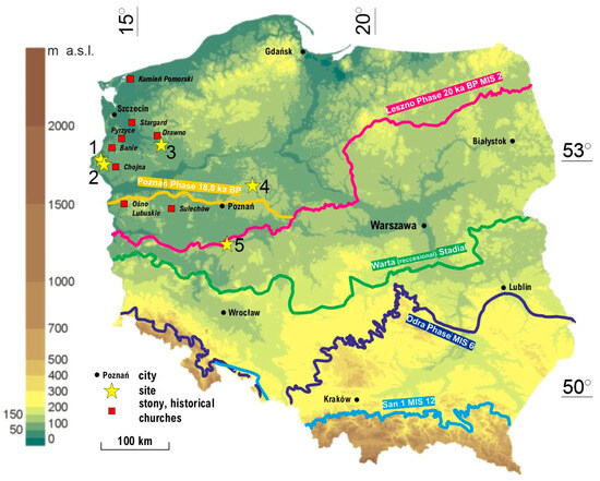
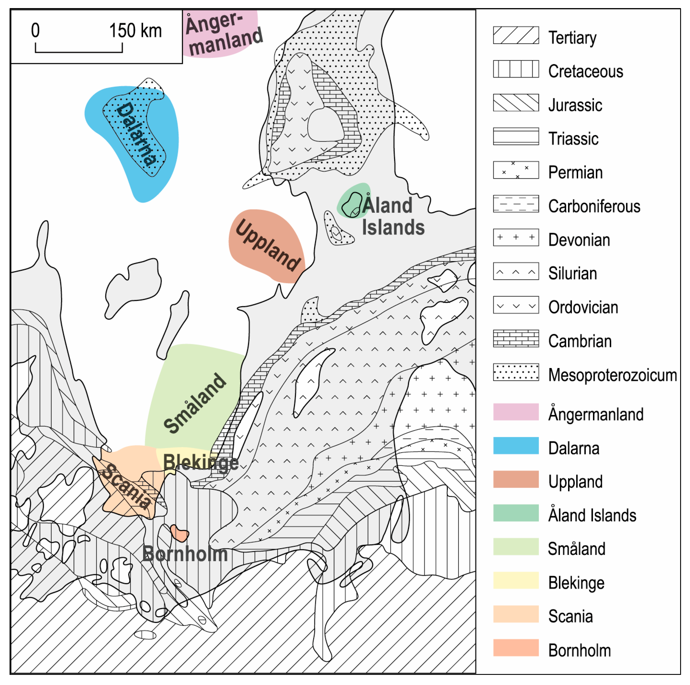
Figure 1.
The locations of five historic sites where geoheritage is intertwined with cultural heritage against the map of the extent of Pleistocene (Scandinavian) glaciations in Poland. Only the most important glaciations, stages and phases are shown. 1—Church of St. Elizabeth of Hungary in Dolsk (Myślibórz Lake District), 2—Church of the Holy Spirit in Moryń, 3—Paved Salt Trail in Ostrowiec, 4—Megalithic Tomb of the Globular Amphora Culture in Kierzkowo, 5—The Benedictine Abbey in Lubin. The locations of some other stony, historical churches are presented on the map. Source: Hypsometric map of Poland (only) released under the GNU Free Documentation Licence, changed by author; for other stony, historical churches see [7,13].
In these cultural heritage sites, erratic boulders primarily fulfil a structural function. However, are they the only ones? Some authors [16,18,31] note that the walls of stone architectural monuments are ready-made, albeit unexplained, expositions showing the diversity of rocks and their different formation. The presence of stone blocks in historic buildings is linked to traditions, culture and art, as well as representing a particular identity of the region. These buildings have been discussed by art historians and architects (e.g., [6,7]), although their analyses tend to be limited to a brief mention of the use of Scandinavian granites (only!) in their construction. For example, [26,27,30] state that one building is constructed from red granites, while [6] refers to it as being made from what are colloquially known as fieldstones. The argument for recognising cultural heritage linked to geology has been presented by numerous authors [32,33,34,35,36]. This issue has been acknowledged for some time in Germany and Denmark, where historic buildings are more accurately identified in terms of their construction materials. Papers [9,10,12,14,15,16] discuss the Scandinavian origin and the type and age of the material used for the small rural churches and the impressive, majestic urban churches of Mecklenburg and Vorpommern, Brandenburg and Denmark.
In considering the broader issue of research on cultural geodiversity in Poland, it is worthy of note that the works of [37,38] describe the stone paving of the Old Market Square and the Upper Town in Poznań as an element of cultural heritage. The authors examine the provenance, construction methodology and challenges associated with the preservation of this stone heritage. In their work, the authors present an analysis of erratics in the culture and art of Poznań. Similarly, [39] examines the tourist value of cultural geosites in Poland. A comprehensive analysis was conducted to examine the characteristics of the geosites included in [40], possessing cultural values (cultural geosites). The intersection of geodiversity and cultural heritage in urban contexts has been explored by the authors of [41,42,43,44]. They studied rock types and Scandinavian indicator erratics in Pruszków (middle Masovia, central Poland [41,42]) and rock types that contain abundant fossils in Poznań (western Poland [43,44]), respectively. The geoheritage was identified in buildings and most emblematic monuments of both urban organisms. The role of mountain guides in the Sudeten mountains in southern Poland as facilitators of the delivery of cultural ecosystem services in the Karkonosze National Park is the subject of research. This research was conducted in [45].
The presence of numerous large Scandinavian erratic boulders is a significant aspect of the geoheritage of north-western Poland, enhancing the region’s geodiversity, especially within the young glacial landscape. This landscape features flat-bottomed and/or hummocky moraines, formed from glacial tills deposited at the base of the ice sheet starting around 20,000 years ago [46,47,48,49]. The region is home to a multitude of channel, moraine and dead-ice-block lakes. The direct foreland of the ice margin is constituted by sandy outwash plains. Fluvial relief was subsequently formed in the further foreland of the glaciomarginal zone, following the retreat of the ice sheet. These are shallow and wide ice-marginal valleys, parallel to the head of the ice sheet, which are filled with alluvial deposits and contain functioning meanders and overgrown paleomeanders.
In the context of abiotic ecosystem services’ or geosystem services’ theory [50,51,52,53,54], erratic boulders, present in historical objects, play different functions and offer numerous benefits for the local society. The function of erratic boulders can be described as follows: construction, cognitive (gaining knowledge and understanding), educational, pro-ecological, geoethical, geoenvironmental, protective, aesthetic and in support of sustainable regional development. These multiple meanings of erratic boulders are used in geotourism, i.e., nature tourism aimed at promoting geosciences and, in parallel, the conservation of geoheritage (e.g., [55,56,57,58]. As a branch of cognitive tourism, geotourism makes use of the results of basic geology research for practical purposes, such as the creation of a new tourism product [59,60,61,62]. It also recognises historical sites that show a close relationship with geology.
2. Objectives and Research Methods
In light of the above, the aim of this paper is to present five examples of stony heritage sites in north-western Poland, for the construction of which Scandinavian erratics were used. In order to demonstrate the integration of culture and geological heritage, a comprehensive inventory of the stone material is presented, categorised according to petrographic types and indicative erratics. This represents the inaugural analysis of its kind within the study area. The analysis encompasses all stone material at each of the study sites, from bedrock to the height of the potential geotourist’s eye. The author then aims to identify those geosystem benefits [52,54] that the heritage sites discussed in detail provide. The article considers the principles of geoethics [63,64,65,66] and the sense of place [67] in order to demonstrate the potential for instilling a sense of pride in cultural heritage and deepening attachment to national roots among residents and recipients/viewers.
The rationale behind the selection of Sites 1 and 2 for study is their location within the area designated for the planned cross-border Glacial Land over the Odra River Geopark. It is essential to have an understanding of the region’s geological heritage in order to establish a form of geoconservation that is based on attractive sites that demonstrate a link to this past. Site 3 is situated within the Drawa National Park, where the management is pursuing initiatives to diversify the tourist product. Furthermore, in addition to rafting on the Drawa, artefacts that have historically been associated with the region, for example, due to their construction material, are being promoted to tourists. This author was afforded the opportunity to participate in an interdisciplinary project on the megalith in Kierzków, which resulted in the inclusion of this valuable object in the study. Finally, object 5, previously studied by Skoczylas [30,68], has now been the subject of further research based on an expanded workshop background. All cultural sites bear witness to the geological past of the regions with which they are associated. The dissemination of knowledge concerning the presence of these attractive objects through geotourism can contribute to the sustainable development of peripheral tourist areas [69].
Selected sections of the walls were measured and photographed with a scale and colour standard. The next phase involved petrographical and indicator erratic boulder analyses (Figure 2) based on 30 years of personal experience. This author’s own reference rock collection from outcrop exposures in Scandinavia was also utilised. Additional assistance came from author’s publications on Scandinavian glacial erratics [4,70] and atlases of Scandinavian indicator erratics [71,72,73,74,75,76,77,78]. Boulders were identified and classified into groups: granites, porphyries, gneisses, granito-gneisses, sandstones, quartzites, unidentified rocks and others, with attention to indicator erratics (e.g., [1,4,71,72,75]. Macroscopic examinations were conducted non-invasively, without interfering with the monument’s surface, using only water to enhance the colour contrast of minerals. After the petrological identification and classification of erratics, the analysis results were transferred to the photographs. The stone material used was counted and basic statistical calculations were performed in parallel.
Figure 2.
Locations of outcrops of crystalline and sedimentary rocks—source areas of erratics from glacial deposits of the European lowlands. Drawing by M. Gościńska-Kolanko.
While conducting field research, attention was given to current and potential future geosystem services. Among the latter, Gray et al. [52] include cultural (e.g., local landscape character, geotourism and leisure, cultural, spiritual and historic associations, artistic inspiration, social development) and knowledge ones (e.g., earth history, history of research, environmental monitoring and forecasting, educating and employing both geo-interpreters and relevant services to maintain cultural assets in the least altered state possible). These services are capable of ensuring the sustainable development of touristically peripheral areas [69].
3. Study Area
The study area is located in western Poland. Sites 1–3 (Figure 1) are situated in the West Pomeranian Lake District, while sites 4–5 are within the boundaries of the Wielkopolskie (Greater Poland) Lake District.
The West Pomeranian Lake District is primarily characterised by glacial landscapes, which are predominantly hilly and undulating. Locally, there are also flat and undulating glacial and fluvioglacial landscapes. These are intersected by the landscapes of valleys and depressions, including floodplain plains and terrace plains, which are mainly represented by ancient valleys and river valleys.
The study area within the Wielkopolskie (Greater Poland) Lake District was shaped during the Vistulian glaciation (MIS 2; [49]). The main stadial of this glaciation is evidenced by the presence of latitudinally oriented moraine hills. The macroregion is traversed by the meridionally oriented breakthrough valley of the Warta River and the Gopło and Żnin channels. The Greater Poland Lakeland is characterised morphologically by flat and undulating moraine uplands, which are occasionally hilly, as well as by moraine elevations in marginal zones. These forms are composed of till clays as well as glacial sands and gravels. Additionally, outwash plains, constructed from glaciofluvial sands, are present.
The landscapes are primarily lowland, characterised by flat and undulating fluvioglacial plains, the presence of dune hills and hills, as well as flat, undulating, hilly and elevated glacial landscapes. Furthermore, there are accumulating valley and depression landscapes, including floodplain valley floors and overbank terraces.
4. Overview of Historical Objects
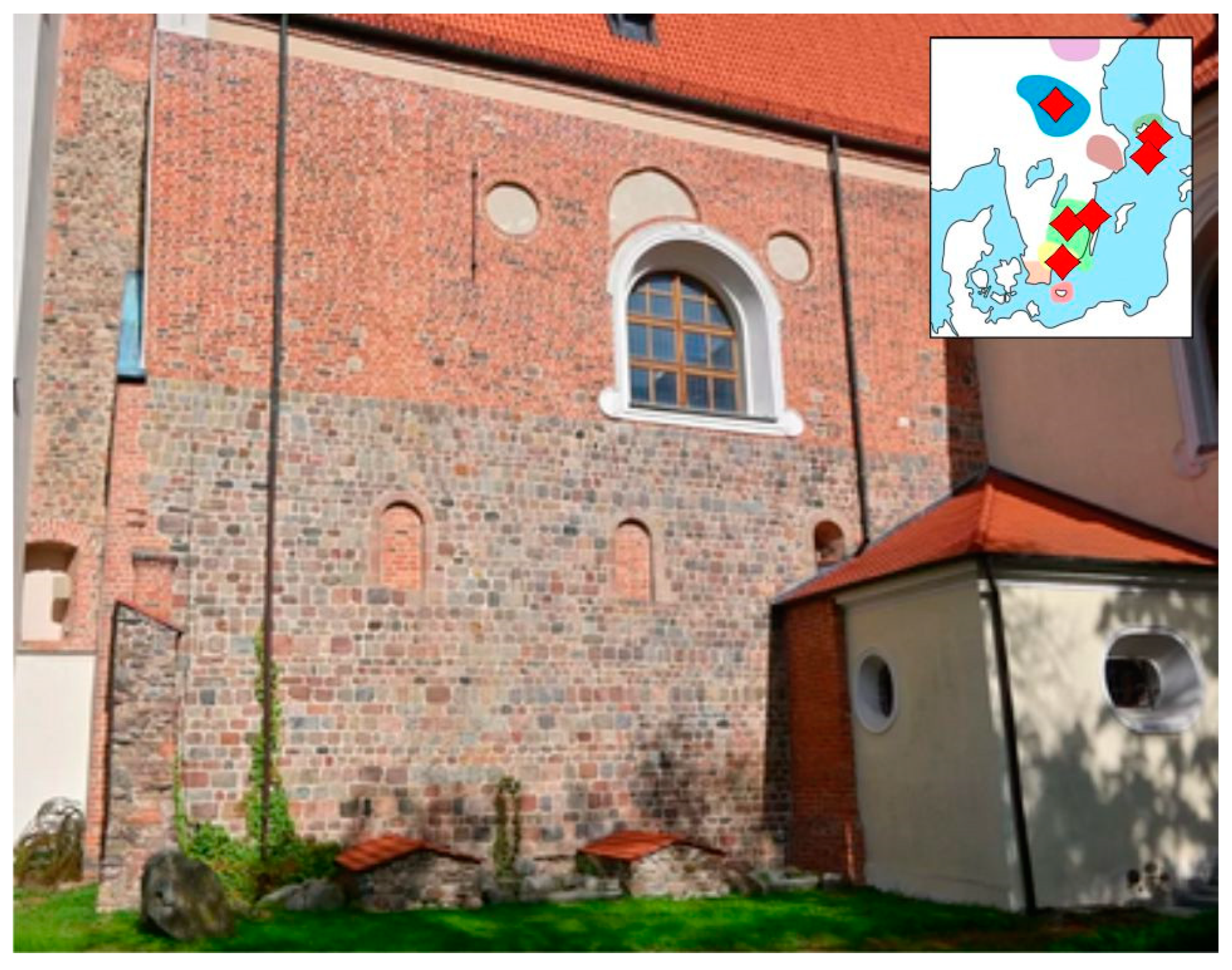
4.1. Church of St. Elizabeth of Hungary in Dolsk (Myślibórz Lake District); No. 1 in Figure 1
The church is situated within the planned cross-border Glacial Land over the Odra River Geopark. It is evidently a well-known local landmark, and it is probable that it is also a popular tourist destination. However, no tourism statistics have ever been compiled for this location. With the establishment of the geopark, the hosts of the site and the region hope that the historic church (built in 13 C.) will receive greater publicity.
It is registered in the register of historical monuments under no.: PL.1.9.ZIPOZ.NID_N_32_BK.111886, PL.1.9.ZIPOZ.NID_E_32_BK.419173. It also exists in Internet sources [79,80].
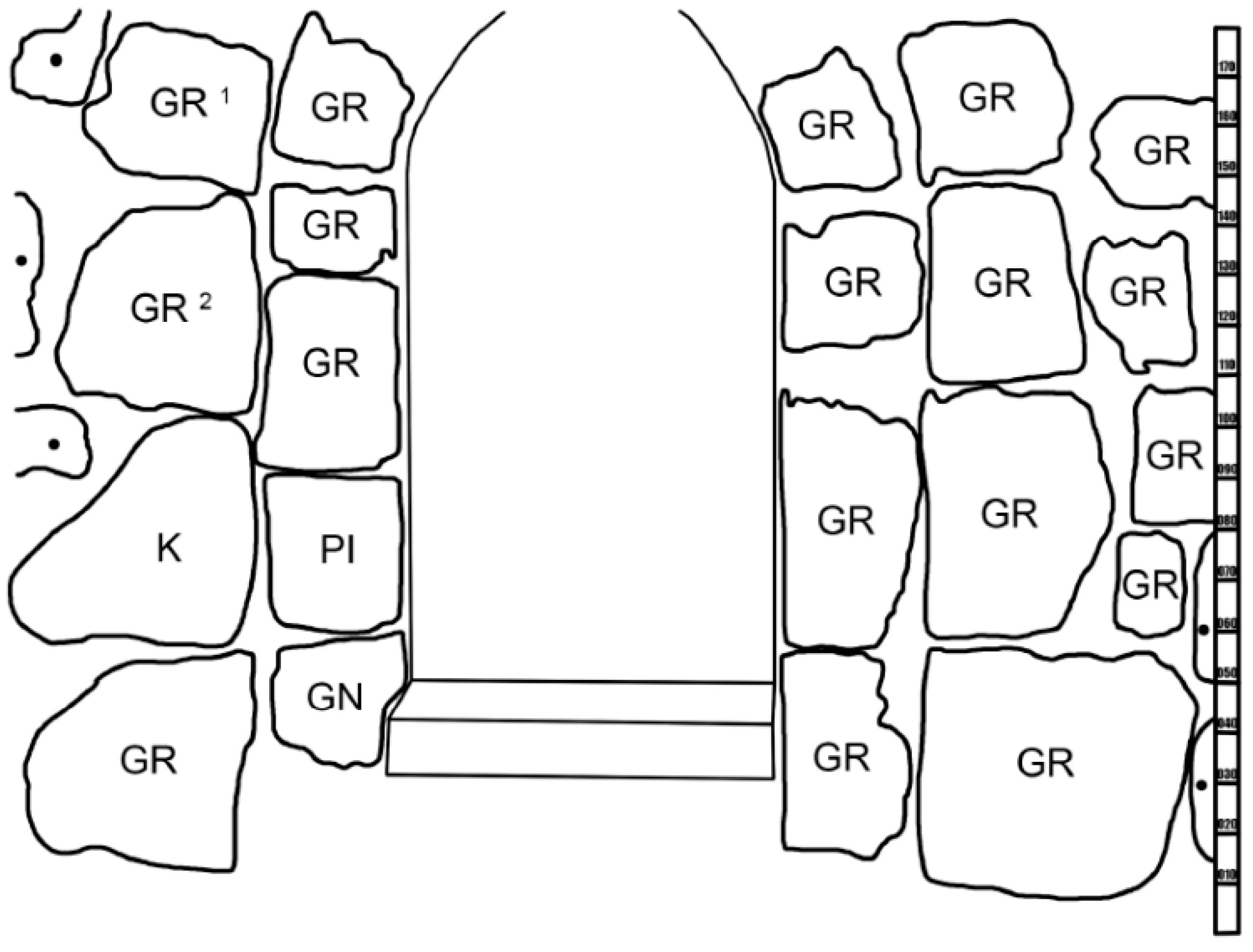
The stony material used to construct the granite church, dating from the second half of the 13th century (Figure 3), was subjected to petrological analysis (Figure 4). The analysis revealed that among the 841 examined boulders, the most numerous petrographic type was granite, constituting 64% of all analysed boulders. The northern wall of the church is a good example (Figure 5). Gneisses accounted for 14%, sandstones and quartzites 5% each, and granite–gneisses 4%, while porphyries were the least numerous identified group, comprising less than 1%. However, 8% of the samples could not be identified.
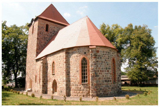
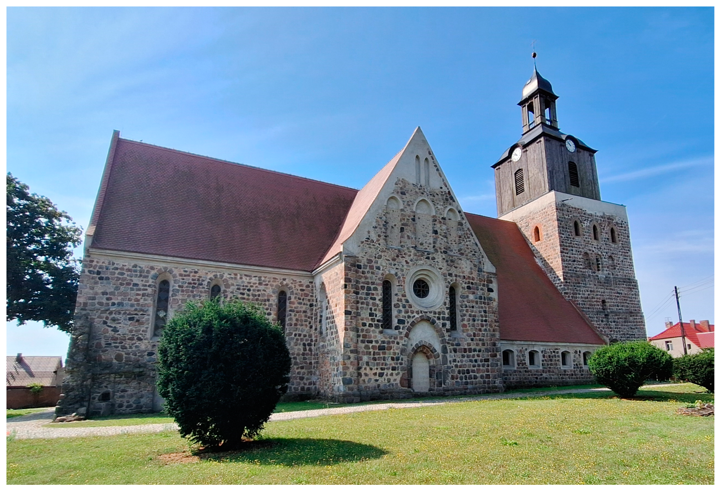
Figure 3.
The Church of St. Elizabeth of Hungary in Dolsk underwent detailed petrographic analysis and identification of guide erratics. View from SE. Photo by stud. E. Bartczak, 2010.

Figure 4.
The petrographic analysis of the northern wall, part II, in the Church of St. Elizabeth of Hungary in Dolsk. GR—granite, GR1, GR2—Aland quartz granites (indicator erratics), GN—gneiss, K—quartzite, PI—sandstone, IN—other. Anal. by stud. E. Bartczak and M. Górska-Zabielska. Drawing by stud. E. Bartczak.
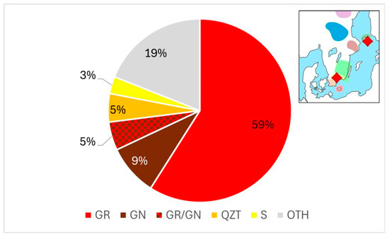
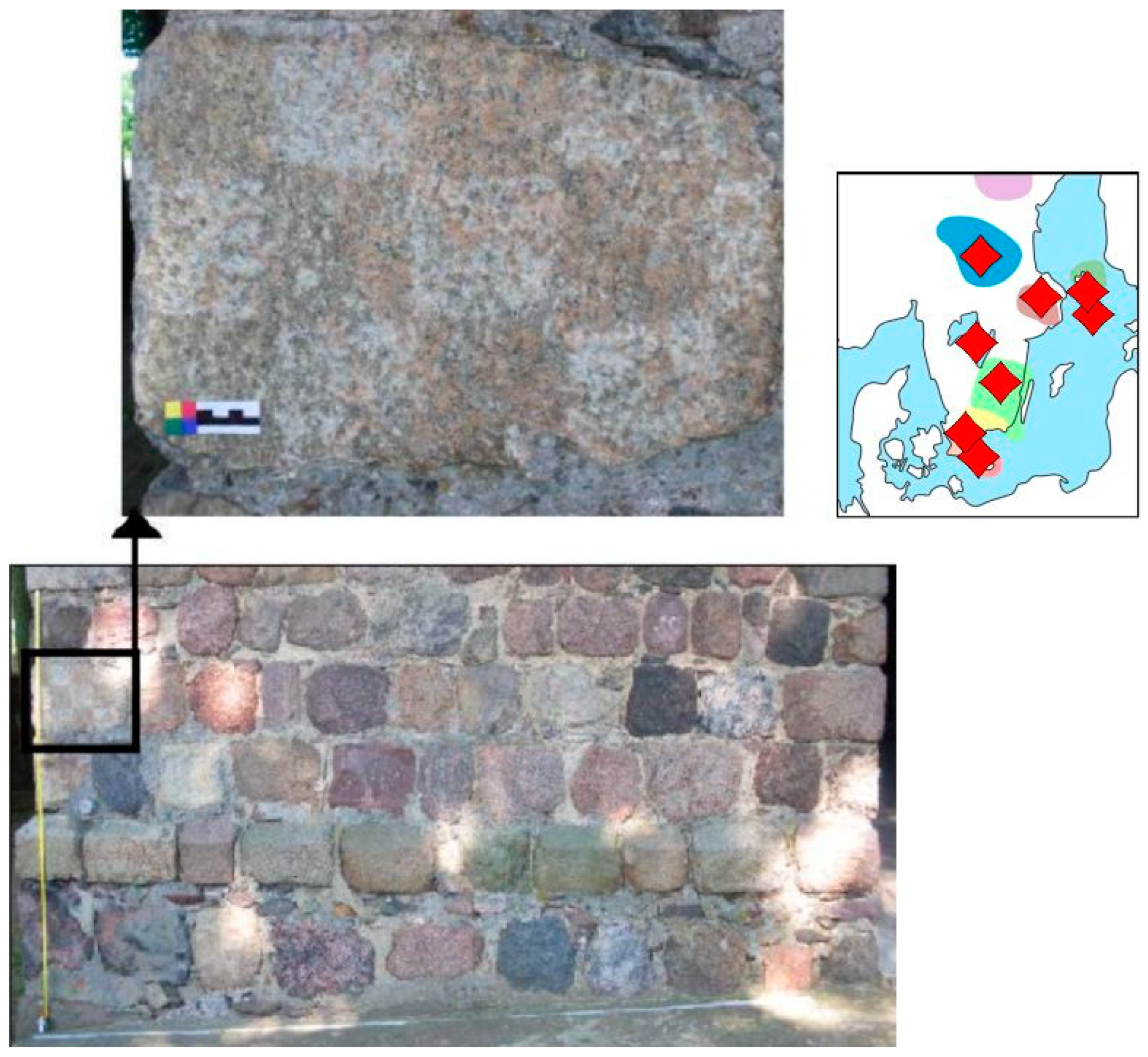
Figure 5.
Share of petrographic types of stone cubes—north wall of the Church of St. Elizabeth of Hungary in Dolsk. GR—granite, GN—gneiss, GR/GN—granite–gneiss, QZT—quartzite, S—sandstone, OTH—other. Location of some indicator erratics in the right upper corner; for legend see Figure 2. Anal. by stud. E. Bartczak and M. Górska-Zabielska. Drawing by author.
In the studied object, 57 indicator erratics were identified, including 54 granites and 3 porphyries, along with 26 indictive erratics. The most numerous indicator erratics originate from the Åland Islands (29 pieces), accounting for 35% of all identified indicator erratics, while the least numerous are those from Blekinge and Bornholm (Figure 5).
The checkerboard motif [68] was also used in the church in Dolsk. Given the meticulous execution, it can be inferred that it was added to enhance the church’s decorative appeal. This theory is supported by its prominent placement: on the left side of the base of the arch, on the third step of the western portal’s jamb, counting from the outside. The asymmetric placement of the granite ashlar with the checkerboard suggests that the sign might have also served as a stonemason’s mark or a guild signature.
4.2. Church of the Holy Spirit in Moryń (Myślibórz Lake District); No. 2 in Figure 1
The historic Church of the Holy Spirit in Moryń (Figure 6), built in the 13th century, is one of the oldest churches in Western Pomerania. Most likely for this reason and for its location within the well-known town of Moryń, it is visited by tourists. However, a paucity of data exist regarding tourist traffic to the site. The information of this church exists under links [81,82]. The church and the historic city walls are listed in the Central Register of Polish Geosites under link [83].

Figure 6.
The stony Church of the Holy Spirit in Moryń, viewed from the north side. The photograph was reproduced with permission from the author Sławomir Pawlak, 31 July 2024.
The church is constructed from glacial erratic boulders, of which 2147 have been petrologically analysed [84]. Of these boulders, 46% are granites, 23% are gneisses and 7% are quartzites. Additionally, 17% of the rocks could not be identified due to weathering and colonisation by epilithic flora. The percentages of porphyries, basalts and Jotnian sandstones each did not exceed 7%.
In the analysed object, 87 (4.06%) indicator erratics and 20 (0.93%) indictive erratics were distinguished. The remaining 95.85% are attributed to erratics originating from unidentified source regions in Scandinavia. Among the indicator erratics, 15 types were identified. The most common were Småland granites (42.06%), Åland granites, Åland rapakivi, and Månsta porphyries from the Åland Islands (20.56%). The set of studied objects also included individual indicator erratics from the Baltic area (6.54%: red Baltic porphyry, brown Baltic porphyry, Mandelstein), Sweden (5.61%: Kinne diabase, Uppsala granite, Ragunda granite), Bornholm (2.81%: Bornholm granite), Dalarna (1.87%: Dalarna porphyry), Blekinge (Karlshamn granite), Scania (Scania basalt) and others (Figure 7).
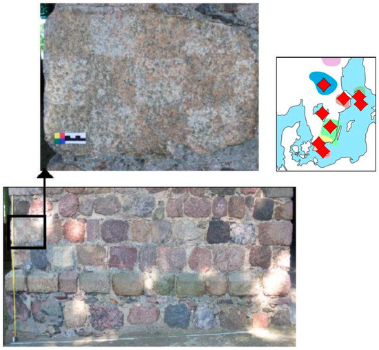
Figure 7.
The church’s south façade is adorned with a checkerboard ornamentation. Location of indicator erratics from the analysed area in the right upper corner; for legend see Figure 2. The small colour card is a reference to the colours of the rock. Photo by stud. M. Sroka, 2010.
Noteworthy is the presence of an ornament with a checkerboard motif [68] on one of the granite ashlars of the southern elevation of the tower (Figure 7).
This particular detail was achieved in the stonemason’s workshop by the intentional application of a smoothing technique to some of the squares, while the remainder were left rough. In addition to its typical decorative function, the chequerboard mark may have served as the signature of the stonemasons’ guild. The area of occurrence of the chequerboard motif is strictly defined, limited to Pomerania on both sides of the Oder River, as well as the Uckermark and northeastern Brandenburg [6]. These and other signatures carved in stone have survived for hundreds of years and still provide valuable information today about aspects such as workshop organisation, construction techniques and social life [84].
4.3. Paved Salt Trail in Ostrowiec (Drawieński National Park); No. 3 in Figure 1
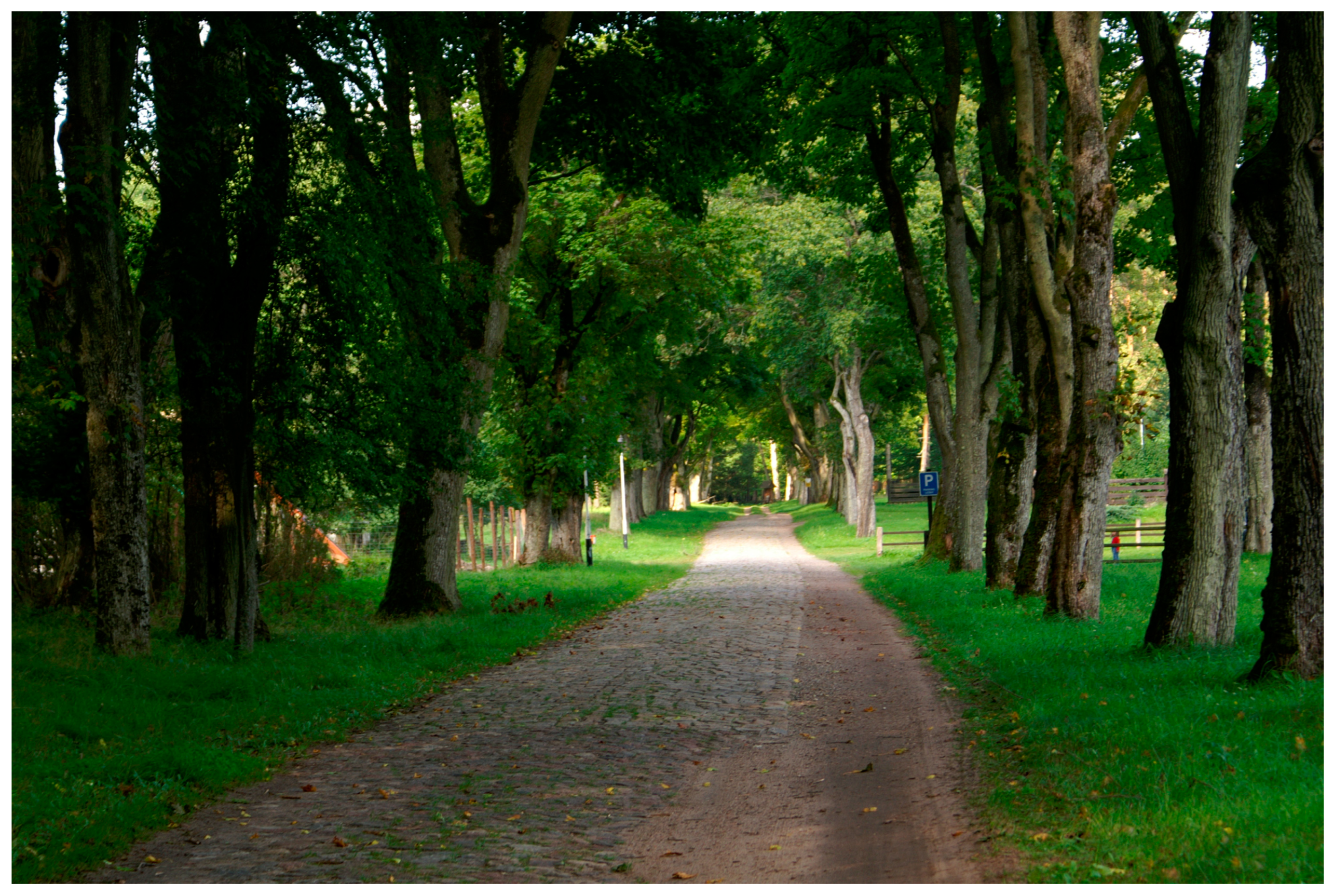
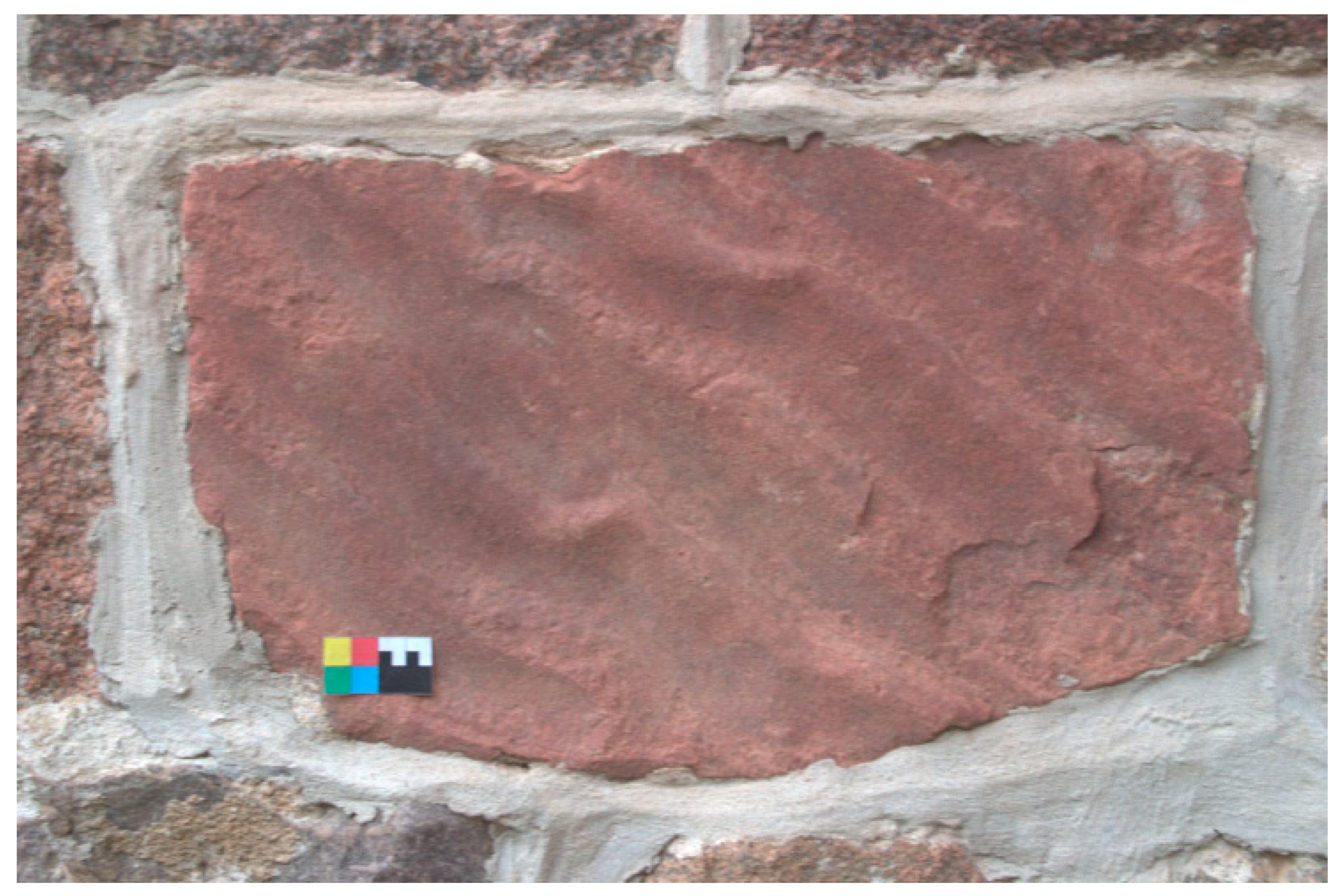
The red S. Czarniecki sightseeing trail traverses sections of the historic paved Salt Trail, designated as Drawno-Barnimie-Zatom (14.3 km). The route, situated along the Drawa River and through the Drawno Forest, is accessible to pedestrians and cyclists [85]. It dates back to medieval times, when it was a trade route used to carry salt from Kołobrzeg, on the Baltic Sea, to Wielkopolska.
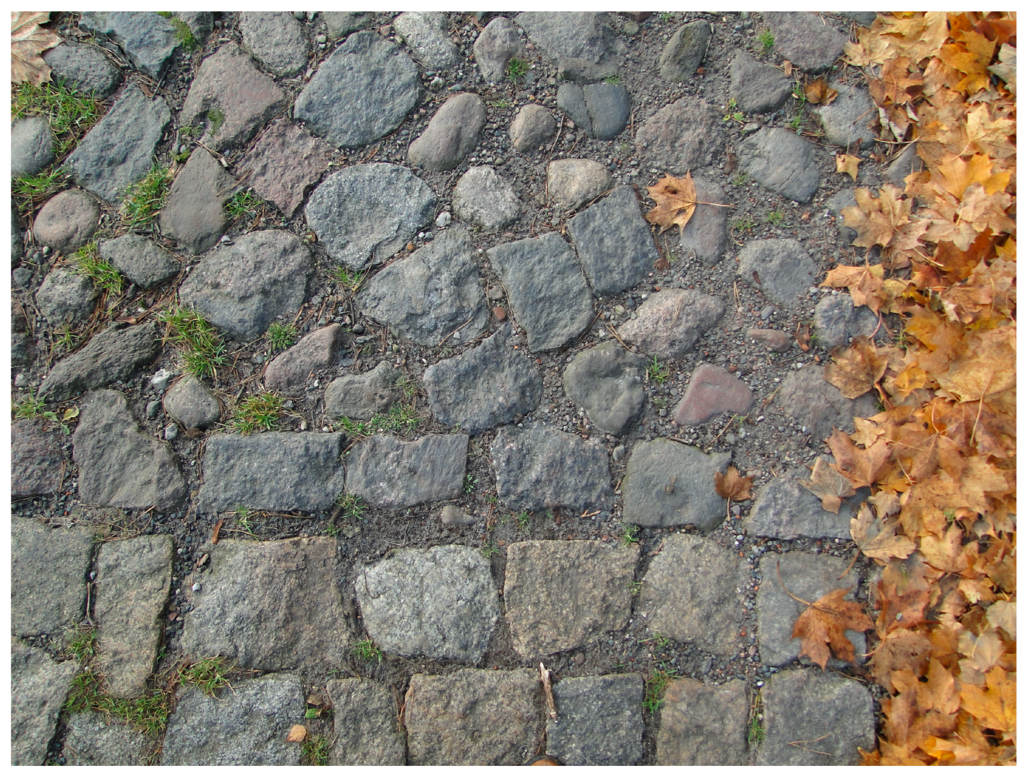
Built in the 19th century by German foresters for forestry work, the paved road from the village of Głusko to the settlement of Ostrowiec in the Drawa National Park consists of two parts. The first part, from the forest parking lot near Lake Ostrowieckie to the first buildings of Ostrowiec, features original cobblestones dating back 200 years (Figure 8), laid in a rather random manner. The second section is within the boundaries of the Ostrowiec settlement, where the rock material was arranged in an orderly manner, selecting the shape of the cobblestones. The distinction between both random and ordered distribution of paving can be seen in Figure 9.
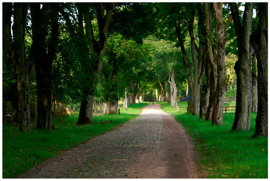
Figure 8.
Historic (19 C.) paved Salt Trail in Ostrowiec, Drawieński National Park. Photo by M. Górska-Zabielska, 2010.
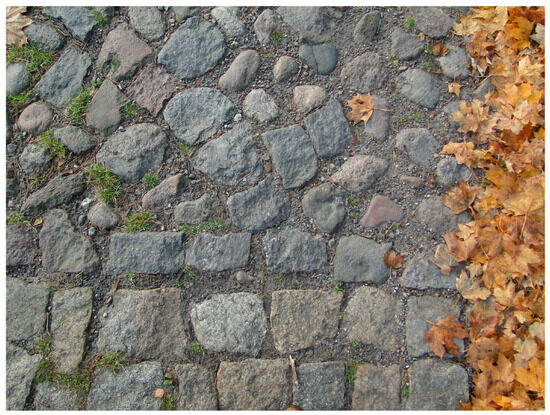
Figure 9.
The distinction between stone paving manner: chaotic in the upper part, and orderly in the lower part of the historic Salt Trail in Ostrowiec, Drawieński National Park. Photo by stud. J. Starczewska, 2011.
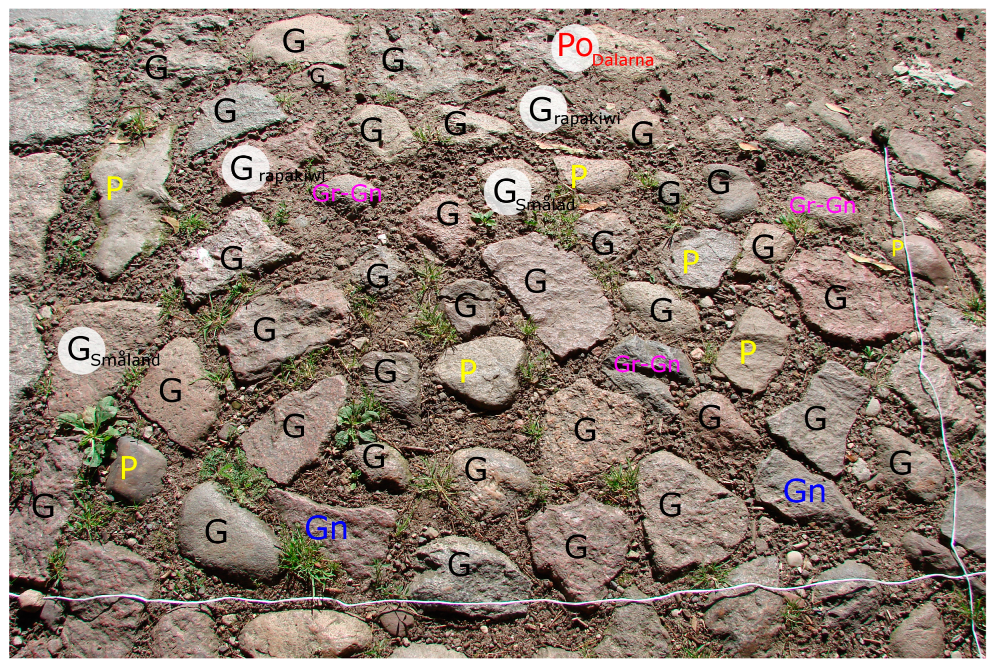
In the analysed first section of the pavement (comp. Figure 10), 234 rock specimens were identified. Granite rocks predominated in each fragment designated for detailed analysis as well as along the entire road, constituting 72.6% of the studied population (Table 1). Sandstones rank second in terms of quantity, comprising 12%. Metamorphic rocks, such as gneisses, are in third place. The remaining types of rocks, including granite–gneisses, quartzites and porphyries, make up a small percentage of all the boulders used.

Figure 10.
Fragment of a paved road in Ostrowiec with markings indicating the petrographic types of rocks. The letters stay for petrographic types: G—granite, Gn—gneiss, P—sandstone, Gr-Gn—granite-gneiss and indicator erratics: Po Dalarna—Dalarna porphyry, G rapakiwi—Aland rapakivi granite, G Småland—Småland granite. Anal. by stud. J. Starczewska and M. Górska-Zabielska. Photo by stud. J. Starczewska, 2011.

Table 1.
Results of petrographic analysis of fragment of paved road in Ostrowiec—contribution of petrographic types. In the right column—the most common indicator erratics of the research section; for legend see Figure 2.
Among all the analysed rocks, only 11 (4.7%) are indicator erratics. Most notably, 9 pieces were identified as granites, which is evident due to their largest number, by far, in the entire studied population of stone material. Primarily, these are granites from Småland, followed by granites from the Åland Islands with distinct rapakivi features. Only two porphyries were identified: one from Dalarna and one quartz porphyry from the Åland Islands.
4.4. Megalithic Tomb of the Globular Amphora Culture in Kierzkowo, Pałuki; No. 4 in Figure 1
The tomb is among the unique prehistoric sepulchral objects in Poland. The results from interdisciplinary research [22] enabled the reconstruction of funeral practises from around 5000 years ago. Presently, the tomb is entirely overgrown, which deters uninformed tourists from exploring it. Additionally, the local community exhibits minimal interest in this historic site, particularly given its location in an arable field and the difficulty of accessing it. This undoubtedly mitigates anthropogenic pressure.
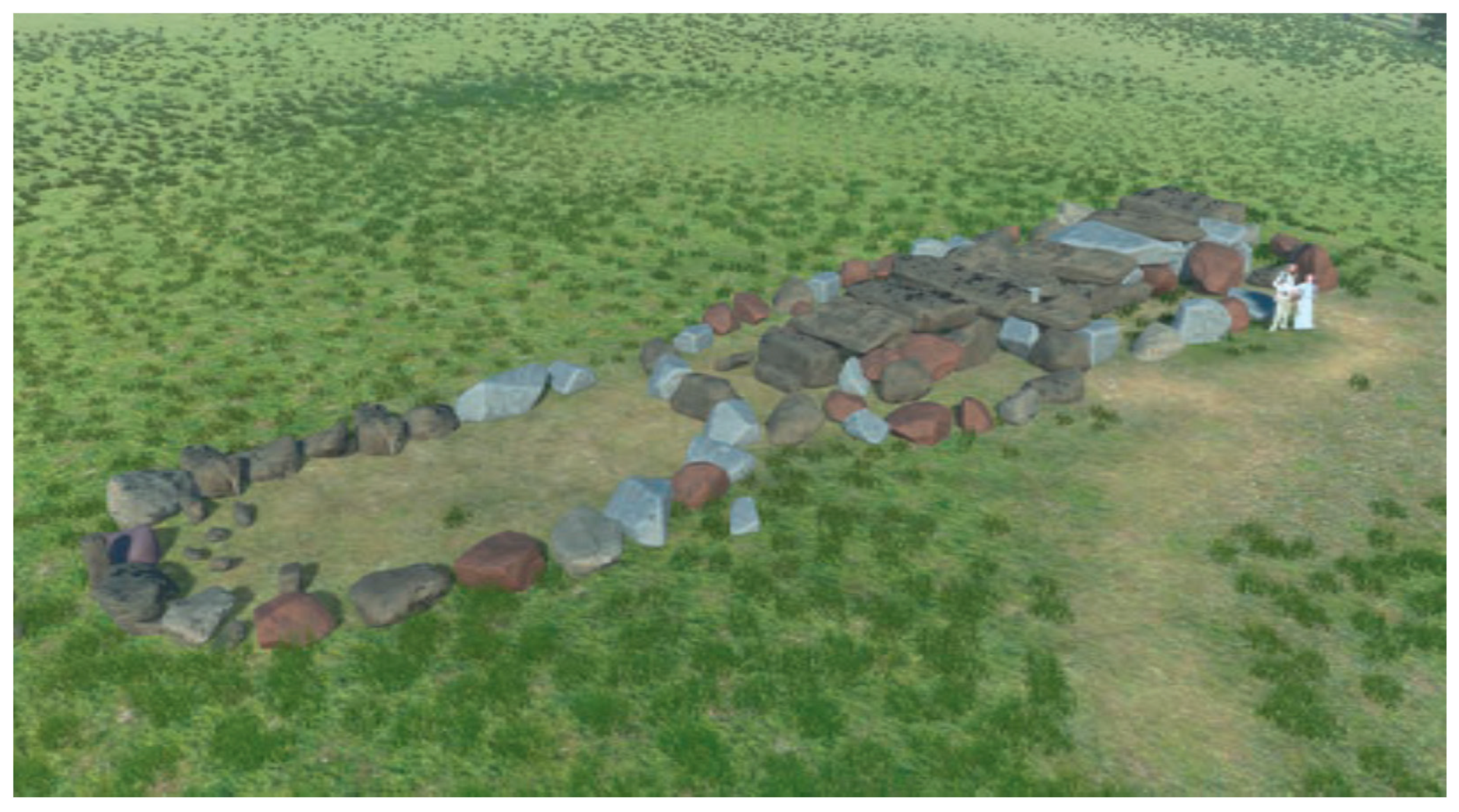
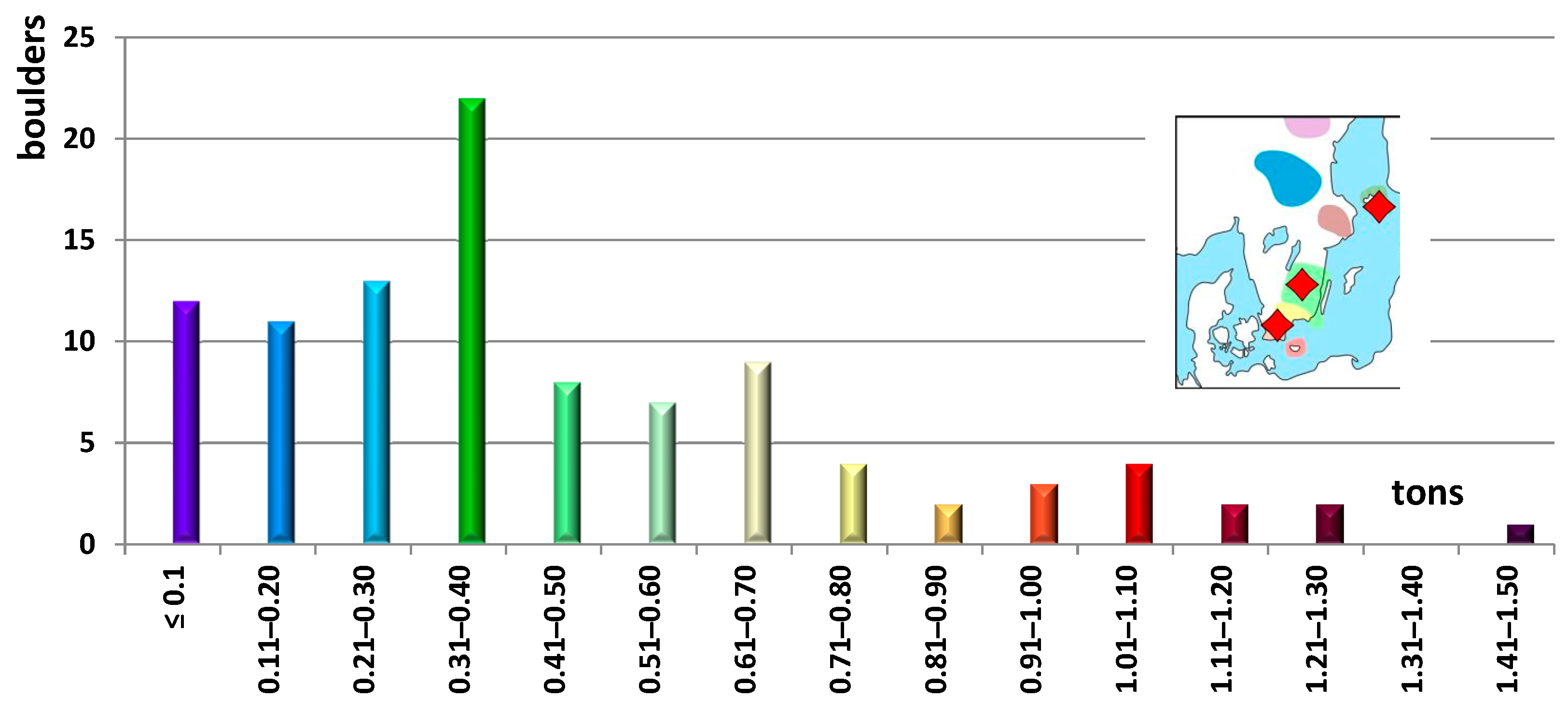
The megalith represents one of the very few corridor tombs in Poland (Figure 11). It was constructed using glacial erratic boulders of various sizes, the largest weighing approximately 1.44 tons. The average weight of a boulder is 456.7 kg (Figure 12). The largest group (22 pieces) consists of boulders weighing between 310 and 400 kg. Half of the boulders exceed 1 tonne in weight. The total weight of all 100 boulders used to erect the megalithic tomb in Kierzków is 45.67 tonnes [86].

Figure 11.
A visualisation of the original appearance of the megalithic tomb in Kierzkowo, without a capping of earth, view from the west. Figure reproduced with permission from the publisher Biskupińskie Prace Archeologiczne, 20 July 2024.
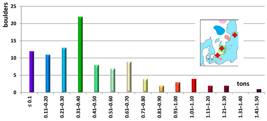
Figure 12.
The number of boulders (in pieces) of the megalith at Kierzków in equal weight (90 kg) ranges. In the right—the location of the most common indicator erratics; for legend see Figure 2. Anal. and drawing by author.
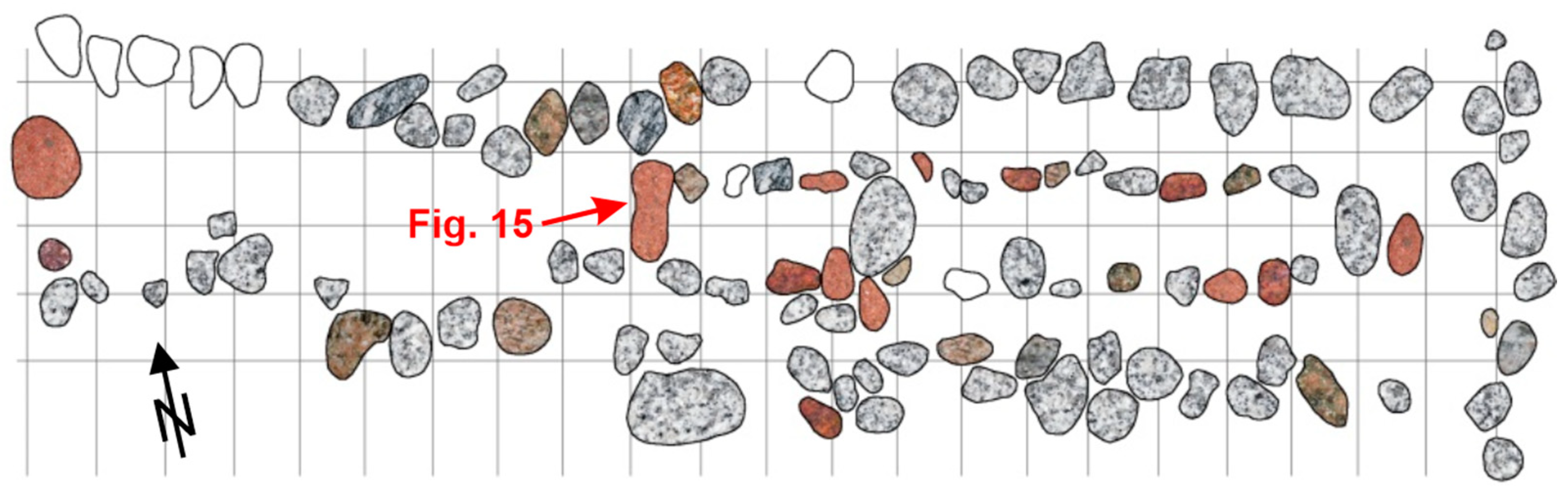
Builders selected locally available rocks that were also highly resistant to weathering. Approximately 90% of the boulders are different varieties of granite (Figure 13), which is not only the most commonly found type of erratic but also a rock with significant hardness. Additionally, single specimens of porphyry, granite–gneiss, gneiss and sandstone were used in the tomb’s construction.

Figure 13.
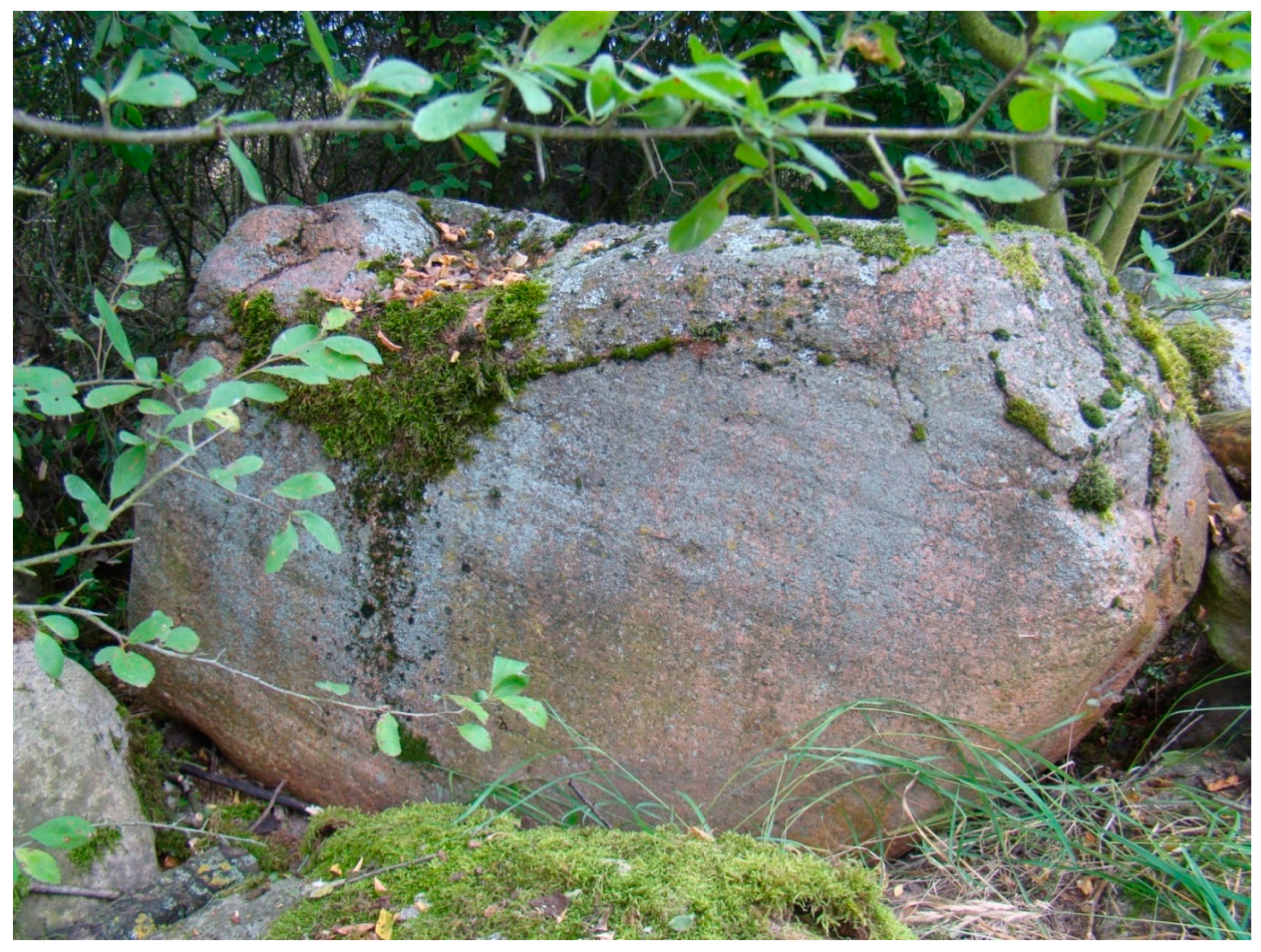
A petrographic and indicator analysis was conducted on the erratics of the Kierzków megalith. The map illustrates the location of the large red quartz granite from the Åland Islands, as depicted in Figure 15. The grid squares have a surface area of 1 m2. Anal. and drawing by author.
Aesthetic considerations likely influenced the choice of materials for the tomb chambers, with red-coloured rocks being preferred for their potential magical significance. Some researchers [87,88] have proposed that the symbolism of colour played a significant role in the construction of megalithic buildings in Western Europe. Rocks with distinct, decorative structures were also selected for the primary part of the megalith. Contrary to Wiślański’s [89] opinion, the flat surfaces of the boulders forming the internal walls of the chamber (Figure 14) were not intentionally flattened. They were rather utilised as naturally flat surfaces shaped by morphogenetic processes, such as glacial polishing at an ice sheet substratum. These morphogenetic processes, including exaration, transport and deposition of boulders, are evidenced by the micro-relief on the surfaces of many studied boulders (e.g., glacial striae; Figure 15). The stone material used for the sepulchral object mainly consists of Scandinavian erratics originating from the southern and southeastern regions of present-day Sweden and the Åland Islands archipelago.
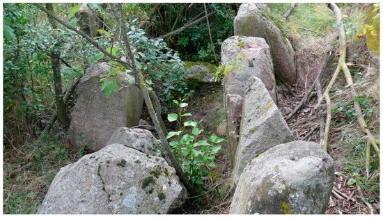
Figure 14.
The burial chamber of the Kierzków tomb is encircled to the south and north by two rows of erratic boulders. The majority of the boulders are found in their original position. Photo by M. Górska-Zabielska, 2016.

Figure 15.
At the western end of the burial chamber in the Kierzkowo megalith (see Figure 13), there is a large red Åland quartz granite with clearly defined glacial striae on a polished surface. Photo by I. Hildebrandt-Radke, 2016.
4.5. The Benedictine Abbey in Lubin (South Wielkopolskie [Greater Poland] Lake District); No. 5 in Figure 1
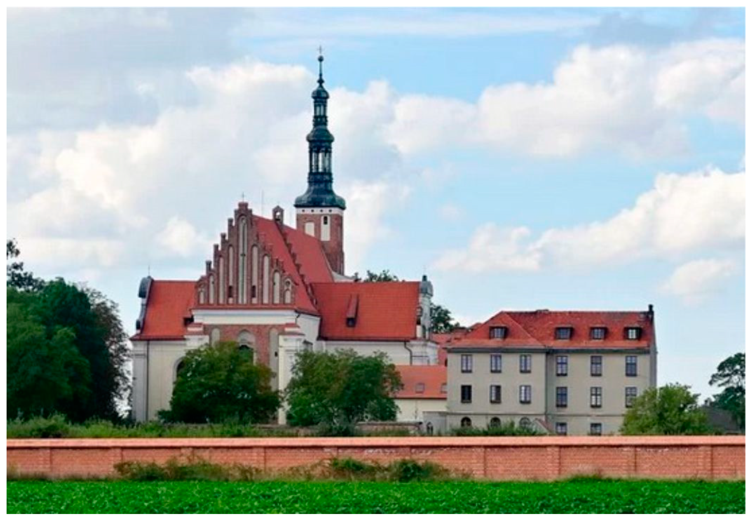
The abbey was constructed and rebuilt from the late 11th century [90] (Figure 16). In accordance with the decree of the President of the Republic of Poland of 9 December 2009, the Lubin Benedictine Abbey Complex was designated a historical monument (No. 57 in [91]). The objective of the protection of historical monuments is to safeguard, on account of their historical, spatial, architectural and intangible values, one of the most ancient monastic centres, a location associated with significant figures for the culture and history of Poland. A telephone appointment may be made to visit the monastery with a monk guide. The tour lasts approximately half an hour.
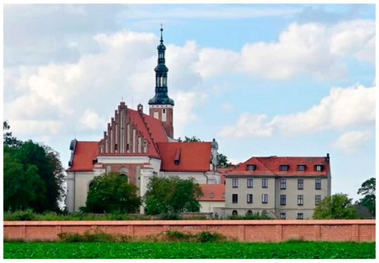
Figure 16.
Benedictine monastery church of the Blessed Virgin Mary in Lubin. https://kierunkowo.pl/opactwo-benedyktynow-w-lubiniu-historia-zapisana-w-murach/; accessed on 24 July 2024. The photograph was reproduced with permission from Marcin Krawczyk, kierunkowo.pl blog for the purposes of scientific work, 27 July 2024.
The Gothic and Baroque renovations obscured the main structural principles and the type of building material used. It was only through excavation work conducted inside the church that the rock material used for the construction of foundations, walls and mortar could be examined. Skoczylas [30] points out that the entire foundations of the monastery church are built from unprocessed rocks, and only the rocks used for the construction of walls show initial processing. Almost 100% of the foundations and walls are made of glacial erratics, with occasional occurrences of limestone rubble, formed in situ, and quartz sandstones not being erratics.
Thanks to archaeological excavations [92], three main phases of construction of Benedictine religious buildings have been identified in the Romanesque period. In the exposed walls and foundations of all phases of building formation, Skoczylas [30,92] indicates that granite (appr. 45%) and gneiss (appr. 22%) were used most frequently. The third petrographic type used in the construction was quartzites (appr. 15%). It is unclear which other petrographic rock types were used at Lubin, as Skoczylas does not provide this information. Similarly, no data are given regarding the indicator erratics used.
A recent analysis of rocks for their Scandinavian provenance on 1103 rocks forming the walls of the abbey (Figure 17) up to a height of about 1.8 m, showed a clear predominance of granite presence (792 pieces = 72%); additionally, 121 gneisses (11%), 61 sandstones (2%), 29 porphyries, 16 quartzites, 16 cryptocrystalline rocks, and 8 pegmatite rocks were identified; 3 stone objects remained unidentified.
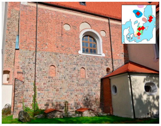
Figure 17.
The analysed, southern wall of Benedictine monastery church of the Blessed Virgin Mary in Lubin. Location of some indicator erratics in the right upper corner; for legend see Figure 2. https://kierunkowo.pl/opactwo-benedyktynow-w-lubiniu-historia-zapisana-w-murach/; accessed on 24 July 2024. The photograph was reproduced with permission from Marcin Krawczyk, kierunkowo.pl blog for the purposes of scientific work, 27 July 2024. Drawing by author.
Among the 57 indicator erratics, the most numerous group consists of Åland rapakivi granites (23 pieces) and Småland granites (14 pieces). Also inventoried were Jotnian sandstone (nine pieces; Figure 18), Karlshamn granite (three pieces), two specimens each of red Baltic porphyry and Dalarna porphyry, and one each of Skolithos sandstone, Tessin sandstone, Västervik quartzite, Emarp porphyry and Venjan porphyrite (Figure 16).
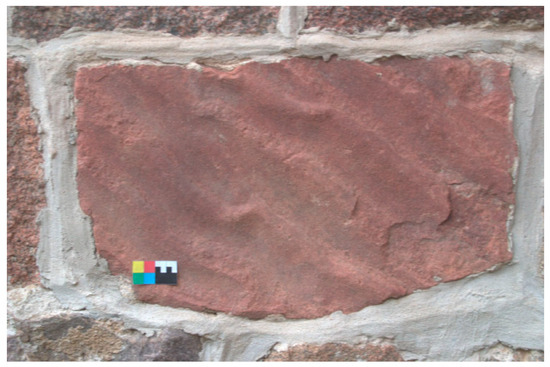
Figure 18.
Jotnian sandstone with ripplemarks visible in the southern wall of the Benedictine monastery church of the Blessed Virgin Mary in Lubin. The small colour card is a reference to the colours of the rock. Photo by M. Górska-Zabielska, 2010.
5. Discussion
The cubes and erratic boulders at the five sites described provide geosystem benefits/services, which in turn meet the needs of their users.
Given that they were constructed between 5000 and 800–700 years ago, they have been serving a constructional purpose ever since. The erratic material serves to illustrate the local abiotic environment and is therefore an integral part of the scientific significance of each historical object. The Scandinavian boulders provide the most compelling evidence of geomorphological processes that occurred between 20 and 15 ka BP [46,47,48,49] in the north-western part of Poland. Over time, they have been perceived as offering religious, contemplative and occasionally protective benefits in situations of military threat.
In discussing the erratic boulders that have been used in the construction of historic structures, it is important to consider their geoenvironmental significance. The geoheritage of Scandinavia provides geoecosystem benefits, which may be defined as goods and services derived from nature. These benefits are of benefit to humans and to nature alike. From the perspective of humans, the stony material fulfils the need for knowledge and education, which can be categorised as a cultural service. From the perspective of nature, boulders fulfil three functions: firstly, they provide mineral resources; secondly, they regulate bio-nature by providing nutrients (minerals for the soil); and thirdly, they support the securing of ecological balance and homeostasis in nature.
In the section below, a detailed examination of the geosystem services that are being provided by the rock blocks that constitute the building materials for heritage sites in the present era is undertaken.
The erratic boulders in all five locations serve the functioning of the geosystem and contribute to the geodiversity of the regions in which they are found. The term ‘geodiversity’ refers to the diversity of the abiotic environment [93,94,95]. This environment is extremely fragile and, once destroyed, it is difficult or even impossible to restore it to its original state on a human scale. It is not possible for damaged inanimate nature (e.g., [96,97,98]) to recover in the following year. The process of returning to a state that existed prior to destruction requires a significant amount of time, measured in geological terms. In the case of abiotic processes, this period can span millions of years.
It would be beneficial to raise ecological awareness among tourists and pilgrims visiting the sites in question, as well as local residents, by implementing an accessible and straightforward transfer of knowledge (geosystem educational service). A board displaying the most pertinent information about the historical object from a geological perspective would be an effective means of disseminating this knowledge. The arrangement of the board should be based on the most exemplary examples [99,100]. In addition, experience teaches us to apply a protective coating to protect the board from vandalism by those who do not understand the importance of inanimate natural elements. The design, production and placement of the board can be outsourced to local entrepreneurs, creating new employment opportunities and enhancing the economic situation of the region. This approach aligns with the principles of sustainable development.
The transfer of knowledge can also be facilitated by a geo-interpreter, e.g., [55,101,102]. This may be a teacher, a guide or a local individual with a passion for nature. Any individual can provide information regarding the petrographic type of rock and the recorded traces of processes at different stages in the formation of the erratic boulder. A geography teacher will elucidate the issues of petrographic types of rocks and ice sheet activity; an art teacher will engage in an outdoor drawing exercise; mathematics will demonstrate the principles of measurement and calculation of the volume and weight of a boulder; chemistry will illustrate the types of minerals and teach their chemical formulas; and languages will prompt students to compose an essay or poem about the necessity to protect nature.
The cultural value of boulders is evidenced by their use in the construction of a variety of buildings, representing a slice of the history of art and architecture and bearing witness to the rich past of the cultural landscape of this part of Poland. The building material was widely available (found in fields and forests, in megalithic tombs) and known for its resistance to decay. Consequently, it was used not only for construction purposes but also for decorative elements of representative parts of buildings. Romanesque stone buildings were replaced by easier-to-use bricks with the advent of Gothic architecture. This marked the end of the era of constructing buildings with Scandinavian glacial erratics, which are now regarded as a unique (both temporally and geographically) cultural heritage.
The strategic programme conducted by the Polish Ministry of the Environment from 2008 to 2015 recommended protecting the resources of geological heritage, which are simultaneously objects of cultural heritage. There are various methods to implement this recommendation. One of them is to raise awareness among visitors that the object they are viewing belongs to both resources and therefore requires protection. This can be achieved through informational panels, brochures or geo-storytelling/simple knowledge transfer by a geo-interpreter, as mentioned above.
It is important to note that cultural heritage does not necessarily encompass only positive aspects, like geoconservation [103]; it also includes evidence of human activity, including destructive actions of the surface of the erratics. Such traces are often found in the form of numerous, albeit small, indications of attempts to break the boulder into smaller pieces.
The task of geoethical services is to inspire the local community with an attachment to their roots and to instil pride in their heritage, shaped by previous generations in their small homeland. It is worth pointing out to what extent natural conditions have determined the historical development of humans. Increasingly, the scientific literature emphasises the importance of these services for the preservation of both abiotic and cultural heritage for future generations. This can include promoting the significance of cultural heritage by organising concerts in historic interiors or guiding tours of the Benedictine Abbey in Lubiń, sharing the heritage passed down to the monks by their ancestors. Proper conduct toward historic objects can also be conveyed during cultural events, excursions, pilgrimages, religious meetings, retreats, festivals, orienteering races, photography contests and exhibitions. Informing the public about the current activities of some of these sites (e.g., [104]) ensures that they are remembered.
Places of worship require silence and behaviour worthy of such sites. Appropriate websites (in Polish and German or English) directing people to the object can be found on the Internet, so those interested will certainly find them (e.g., [105,106]). The presence of these sites in the local media helps to keep them from being forgotten. Historic sites are often described on the internet on a page dedicated exclusively to such sites, e.g., [107,108].
All these efforts support or awaken a sense of place in the audience, counteract atomistic behaviours, restore ecological balance, ensure the benefits of the geoecosystem and pave the way for a more sustainable and resilient future.
Pro-environmental, educational services aim to sensitise the inhabitants to inanimate nature, encouraging them to refrain from destructive actions and instead to preserve and provide professional care for these natural resources. When these behaviours and beliefs are internalised and adopted as their own, they lead to conscious decisions about the legal protection of the geoobject (an object that is both a product of and a component of the geoheritage). The official conservation of these natural features is provided for by the Nature Conservation Act 2004 [108].
Erratic cubes provide aesthetic services, particularly when situated in an object in a prominent location. During the prehistoric era, the symbolic significance of erratic boulders’ colours was acknowledged. Stony blocks served a martyrological function for the inhabitants of that period [22,87,88]. The aesthetic value of exposed erratic boulders was beneficial to them. Their positive assessment was informed by other similar examples. The very striking, almost ornamental, structure and texture of the red Aland rapakivi granites meant that they were often incorporated into the entrance portal of a church, e.g., in Dolsk, dedicated to St. Elizabeth of Hungary. According to [109,110,111], the stony blocks influence parameters of scenic beauty such as scale, condition, balance, diversity, shape and uniqueness, and, therefore, these blocks are of aesthetic value. The most important is colour and size. Apparently, the presence of big stones stimulates tourists’ positive emotions.
On occasion, erratic boulders provide a service of a sentimental nature. Any marks or indications on an erratic cube can be attributed to a donor or a masonry workshop (as mentioned above, while describing the church in Dolsk).
The historical buildings described would not have been constructed without the involvement of the local population and activities of local government (e.g., The Directorate of the Drawa National Park or Institute of Archaeology and Ethnology—IAE—of the Polish Academy of Academy of Sciences and the Museum of Archaeological Museum in Biskupin) in the loading, transportation and installation of the monuments. The boulders enhanced the quality of life of the inhabitants associated with the five projects. The care and protection of buildings today must be delivered by an expert, who will professionally and sustainably preserve and make them available to the recipient.
The optimal method for achieving this is the implementation of geotourism, which has been demonstrated to be an effective instrument for sustainable urban and regional development. Geotourism remains a relatively underdeveloped branch of tourism in Poland. The objective is to safeguard the geological and geomorphological heritage through the effective protection of geosites, the extensive promotion of geological sciences and the advancement of their educational and tourist functions.
Geotourism integrates the natural values of an area with local policies for social and economic sustainability (e.g., [59,112,113,114,115]), providing employment for the local community in the display and geo-interpretation of geoobjects. Tourists can make use of local accommodation and restaurants, which can be easily found and booked, e.g., via https://www.trivago.pl/, https://www.booking.com, or they can find accommodation in a number of agritourism farms in the vicinity of the described sites. Rich tourist offerings (e.g., water tourism on the Drawa River in the Drawa National Park [116], cycling in the lake districts [117,118], sylvan tourism [119] and aromatherapy in the surrounding forests) are available to visitors.
By remaining in a specific location for an extended period, individuals can gain a more comprehensive and nuanced understanding of the place. This can also be achieved through the use of tourist guides and maps (e.g., [120,121,122,123]).
The five objects described are known to the local community. It is to be hoped that these sites are visited by a limited number of tourists with an interest in art history, religion and archaeology. It is likely that they are also recreational hikers and cyclists. There are no statistical data on tourist traffic, which may suggest that the sites are not widely publicised. This state of affairs is beneficial for the conservation status of the historic site, as it is not exposed to destructive anthropopressure. However, targeted and monitored tourist traffic would enhance the quality of life for residents living in tourist-oriented peripheral areas, in line with the principles of sustainable development.
6. Conclusions
Considering the author’s intentions listed at the outset, the following should be stated:
- The historic use of erratic boulders is a topic worthy of further investigation. The use of Scandinavian erratic boulders in north-western Poland as building materials for both sacred and secular structures has been documented since ancient times. Such boulders are found in a variety of structures, including megalithic tombs, Pomeranian churches, town walls, paved roads and cathedrals.
- In cultural heritage sites, these boulders are employed primarily for structural purposes, but they also serve to represent regional traditions, culture and identity. The utilisation of these boulders in historical edifices serves to bridge the fields of geology and cultural heritage.
- The presence of erratic boulders provides a range of geosystem services, including educational, pro-environmental, geoethical, and aesthetic benefits. Such boulders contribute to sustainable regional development and the promotion of geotourism, which in turn enhances the conservation of the geological environment.
- The most commonly used rock type, irrespective of the studied cultural heritage site of western Poland, was granite. Its proportion averaged 50–60% of all analysed rocks. Durability, resistance to deterioration and relatively easy stoneworking are all features that have been noticed in this petrographic type. Stonemasons also frequently used gneisses (approximately 15%) and less commonly sandstones and quartzites. Among the indicator erratics, Småland granites from south-eastern Sweden and rapakivi granites from the Åland Islands were most frequently identified. Additionally, single specimens of such erratics from Dalarna (central Sweden), Blekinge (southeastern Skåne), and other locations were also identified.
- The Megalithic Tomb at Kierzkowo is a significant archaeological site. This prehistoric tomb, constructed with glacial erratics, exemplifies granite as the dominant rock type. The boulders were selected for their durability and aesthetic value, reflecting both functional and symbolic considerations.
- The Church of the Holy Spirit in Moryń is a notable example of Gothic architecture. The church was constructed in the 13th century and features a high percentage of granites and gneisses among the 2147 boulders that were analysed. The checkerboard motif, for instance, serves to highlight the cultural significance of these rocks.
- The paved road in Ostrowiec is notable for its use of granite and gneiss. Constructed in the nineteenth century, this road is predominantly composed of granites, with sandstones and gneisses also present. The boulders, which have been identified as indicator erratics, serve to illustrate the geoheritage of the region.
- The Benedictine Abbey in Lubin is a notable example of the region’s geoheritage. The construction phases of the abbey demonstrate a consistent use of granites, gneisses and quartzites. The presence of indicator erratics from Scandinavia serves to illustrate the geological diversity and historical significance of the building materials.
The results of petrographic studies conducted at five historic sites in western Poland provide a substantial corpus of new knowledge that can be utilised by geotourism in the promotion of geological sciences and nature conservation. This is one of the geosystem benefits that geodiversity provides. By fostering environmental awareness and offering educational services (such as disseminating knowledge about petrography as well as history, including the development of workshops and stonemasonry techniques, green schools, games, competitions, festivals), geotourism can contribute to the sustainable development of regions and the protection of geological heritage. New issues will serve to increase the number of tourists whose interest goes beyond the current tourist offerings.
Author Contributions
The authorship of each figure is indicated; this is typically the author, M.G.-Z. The names of other authors involved in the creation of the photograph, analysis or drawing are provided in the caption. Figures sourced from the internet are accompanied by a valid Internet URL. The relevant figures have been given permission to reprint them and the documents are in possession of the Land editorial office. The author has read and agreed to the published version of the manuscript.
Funding
This research received no external funding.
Data Availability Statement
The data presented in this study are available on request from the corresponding author.
Acknowledgments
I am grateful to the geography students of Adam Mickiewicz University in Poznan for their help in the field research, taking the photos and conducting some statistical calculations. M. Gościńska-Kolanko has drawn the Figure 2. My thanks also go to the reviewers and the Editorial Board of Land for the reviews, suggestions and support.
Conflicts of Interest
The author declares no conflicts of interest and retains the copyright of her drawings included in this article.
References
- Meyer, K.-D.; Lüttig, G. Was meinen wir mit Leitgeschiebe? Geschiebekd. Aktuell 2007, 23, 106–121. [Google Scholar]
- Górska-Zabielska, M. The most valuable erratic boulders in the Wielkopolska region of western Poland and their potential to promote geotourism. GeoJournal Tour. Geosites 2020, 29, 694–714. [Google Scholar] [CrossRef]
- Lüttig, G. Methodische Fragen der Geschiebeforschung. Geol. Jahrb. 1958, 75, 361–418. [Google Scholar]
- Czubla, P.; Gałązka, D.; Górska, M. Eratyki przewodnie w glinach morenowych Polski. Przegląd Geol. 2006, 54, 352–362. [Google Scholar]
- Górska-Zabielska, M. Fennoskandzkie Obszary Alimentacyjne Osadów Akumulacji Glacjalnej i Glacjofluwialnej Lobu Odry; Wydawnictwo Naukowe Uniwersytetu im. Adama Mickiewicza w Poznaniu: Poznań, Poland, 2008; Volume 78, p. 330. [Google Scholar]
- Świechowski, Z. Architektura Granitowa Pomorza Zachodniego w XIII Wieku; Poznańskie Towarzystwo Przyjaciół Nauk, Prace Komisji Historii Sztuki: Poznań, Poland, 1950; Volume 2. [Google Scholar]
- Świechowski, Z. Architektura Romańska w Polsce; Wyd. DiG: Warszawa, Poland, 2000; p. 674. [Google Scholar]
- Prinke, A.; Skoczylas, J. Z metodyki badań nad użytkowaniem surowców kamiennych w neolicie. Przegląd Archeol. 1978, 26, 43–66. [Google Scholar]
- Haiduck, H. Die Architektur der Mittelalterlichen Kirchen im Ostfriesischen Küstenraum; Verlag Ostfriesische Landschaft Aurich: Aurich, Germany, 1986. [Google Scholar]
- Pfeifer, V. Feldsteinkirchen im Flämming. In Ein Kunsthistorischer und Touristischer Führer; Viola Pfeifer Verlag: Berlin, Germany, 1997. [Google Scholar]
- Skibiński, S. Technika “grubego muru” w średniowiecznej architekturze Pomorza Zachodniego. In Ars sine Scientia Nihil Est, Księga Ofiarowana Profesorowi Zygmuntowi Świechowskiemu; Olenderek, J., Ed.; Dom Wydawniczy ARS, Fundacja Kultury Polskiej, Instytut Architektury i Urbanistyki Wydziału Budownictwa i Architektury Politechniki Łódzkiej: Warszawa, Poland, 1997; pp. 235–239. [Google Scholar]
- Ibbeken, H. Die Mittelalterlichen Feld- und Bruchsteinkirchen des Flämming; Berliner Wissenschafts-Verlag: Berlin, Germany, 1999. [Google Scholar]
- Jarzewicz, J. Gotycka Architektura Nowej Marchii. Budownictwo Sakralne w Okresie Askańczyków i Wittelsbachów; Poznańskie Towarzystwo Przyjaciół Nauk, Prace Komisji Historii Sztuki: Poznań, Poland, 2000; Volume 29. [Google Scholar]
- Stilling, N.P. Danmarks Kiker; Politikens: Kopenhagen, Denmark, 2000. [Google Scholar]
- Badstübner, E.; Böttcher, U. Feldsteinkirchen des Mittelalters in Brandenburg und in Mecklenburg-Vorpommern; Hinstorff: Rostock, Germany, 2002. [Google Scholar]
- Bungenstock, F.; Meyer, K.-D. Zeugen der Eiszeit in den Wänden der Kirche von Marx; Niedersächsisches Institut für Historische Küstenforschung: Wilhelmshaven, Germany, 2003. [Google Scholar]
- Król, D.; Woźniak, P.P.; Zakrzewski, L. Kamienie Szwedzkie w Kulturze i Sztuce Pomorza; Muzeum Archeologiczne w Gdańsku: Gdańsk, Poland, 2004. [Google Scholar]
- Riepshoff, H.; Bungenstock, F. Wie die Mauern der Bockhorner Kirche die Geschichte der Eiszeiten erzählen; Niedersächsisches Institut für Historische Küstenforschung: Wilhelmshaven, Germany, 2005. [Google Scholar]
- Kunkel, R. Architektura Gotycka na Mazowszu; Wyd. DiG: Warszawa, Poland, 2006. [Google Scholar]
- Meyer, K.-D. Findlingskirchen in Norddeutschland. In Denkmalgesteine—Festschrift—Wolf-Dieter Grimm; Siegesmund, S., Snethlage, R., Eds.; Schriftenreihe der Deutschen Gesellschaft fuer Geowissenschaften: Hannover, Germany, 2008; Volume 59, pp. 128–138. [Google Scholar]
- Meyer, K.-D. Taufsteine in Norddeutschland. Material, Herkunft und Alter. In Abhandlungen und Berichte für Naturkunde; Verlag Museum für Naturkunde: Magdeburg, Germany, 2011; Volume 33, pp. 5–106. [Google Scholar]
- Nowaczyk, S.z.; Pospieszny, Ł.; Sobkowiak-Tabaka, I. (Eds.) Megalityczny grobowiec kultury amfor kulistych z Kierzkowa. Milczący świadek kultu przodków z epoki kamienia. In Biskupińskie Prace Archeologiczne; Muzeum Archeologiczne w w Biskupinie: Biskupin, Poland, 2017; Volume 12. [Google Scholar]
- Górska-Zabielska, M.; Dobracki, R. Petrographic Garden in Moryń—A new geotouristic attraction in western Poland. Landf. Anal. 2015, 29, 73–80. [Google Scholar] [CrossRef]
- Jóźwiak, K.; Stępień, M. Petrografia okolic Drawnika. In Geościeżka w Dolinie Drawy; Bąkowska, A., Ed.; Wyd. Drawa National Park: Drawno, Poland, 2013; pp. 50–78. [Google Scholar]
- Górska-Zabielska, M. Some geotouristic values of the Drawno National Park—A Project of petrographic route. In Ekomuzeum Rzeki Drawy; Januszewski, S., Ed.; Wyd. Drawno National Park, Foundation of the Open Museum of Technology: Drawno, Poland, 2010; pp. 107–116. [Google Scholar]
- Skoczylas, J. Użytkowanie Surowców Skalnych We Wczesnym Średniowieczu w Północno-Zachodniej Polsce; Wydawnictwo Naukowe Uniwersytetu im. Adama Mickiewicza w Poznaniu: Poznań, Poland, 1990. [Google Scholar]
- Skoczylas, J. Zróżnicowanie użytkowania czwartorzędowych surowców skalnych w Wielkopolsce w neolicie i we wczesnym średniowieczu. In Funkcjonowanie Geoekosystemów w Zróżnicowanych Warunkach Morfoklimatycznych—Monitoring, Ochrona, Edukacja; Karczewski, A., Zwoliński, Z., Eds.; Bogucki Wydawnictwo Naukowe: Poznań, Poland, 2001; pp. 491–501. [Google Scholar]
- Skoczylas, J. Kamień w Państwie Pierwszych Piastów; Opuscula Gnesnensia: Gniezno, Poland, 2016; Volume 12. [Google Scholar]
- Skoczylas, J.; Walendowski, H. Kamień w Zabytkowej Architekturze Ostrowa Tumskiego w Poznaniu. Przegląd Geol. 1998, 46, 1146–1152. [Google Scholar]
- Skoczylas, J. Wykorzystanie Surowców Skalnych w Średniowiecznej Architekturze Lubinia Koło Gostynia. Geologos 1996, 1, 203–213. [Google Scholar]
- Migoń, P. Geoturystyka; Wydawnictwo Naukowe PWN: Warszawa, Poland, 2012. [Google Scholar]
- von Rohrscheidt, A.M. Potencjał turystyki kulturowo-przyrodniczej w Polsce. Gnieźnieńskie Forum Ekspertów Turystyki Kulturowej, Pytanie 65. Tur. Kult. 2016, 1, 203–218. [Google Scholar]
- Reynard, E.; Giusti, C. The landscape and the cultural value of geoheritage. In Geoheritage. Assessment, Protection, and Management; Reynard, E., Brilha, J., Eds.; Elsevier: Amsterdam, The Netherlands, 2018; pp. 147–166. [Google Scholar]
- Olson, K.; Dowling, R. Geotourism and cultural heritage. Geoconserv. Res. 2018, 1, 37–41. [Google Scholar]
- Kubalíková, L.; Kirchner, K.; Kuda, F.; Bajer, A. Assessment of urban geotourism resources: An example of two geocultural sites in Brno, Czech Republic. Geoheritage 2020, 12, 7. [Google Scholar] [CrossRef]
- Pijet-Migoń, E.; Migoń, P. Geoheritage and Cultural Heritage—A Review of Recurrent and Interlinked Themes. Geosciences 2022, 12, 98. [Google Scholar] [CrossRef]
- Skoczylas, J.; Skoczylas, Ł. Kamienne bruki Starego Rynku w Poznaniu jako element dziedzictwa kulturowego. Przegląd Geol. 2020, 68, 535–539. [Google Scholar] [CrossRef]
- Skoczylas, J.; Skoczylas, Ł. Kamienne bruki Górnego Miasta w Poznaniu. Przegląd Geol. 2020, 68, 774–779. [Google Scholar] [CrossRef]
- Zgłobicki, W.; Warowna, J.; Baran-Zgłobicka, B.; Gajek, G.; Jezierski, W. Turystyka kulturowa a geoturystyka. Walory turystyczne geostanowisk kulturowych w Polsce. Tur. Kult. 2015, 6, 51–67. [Google Scholar]
- Central Register of Geosites of Poland. Available online: https://geologia.pgi.gov.pl/geostanowiska/ (accessed on 25 July 2024).
- Górska-Zabielska, M.; Zabielski, R. Geotourism Development in an Urban Area based on the Local Geological Heritage (Pruszków, Central Mazovia, Poland). In Urban Geomorphology. Landforms and Processes in Cities; Thornbush, M.J., Allen, C.D., Eds.; Elsevier: Amsterdam, The Netherlands, 2008; pp. 37–54. [Google Scholar] [CrossRef]
- Górska-Zabielska, M.; Zabielski, R. Stone in an urban space—Its potential to promote geotourism. GeoJournal Tour. Geosites 2019, 26, 1033–1045. [Google Scholar] [CrossRef]
- Wolniewicz, P. Bringing the History of the Earth to the Public by Using Storytelling and Fossils from Decorative Stones of the City of Poznań, Poland. Geoheritage 2019, 11, 1827–1837. [Google Scholar] [CrossRef]
- Wolniewicz, P. Where Geoheritage Meets Cultural Heritage: Historical Stone Use in the City of Poznań, Poland, and Its Economic and Political Background. Geoheritage 2024, 16, 11. [Google Scholar] [CrossRef]
- Kieliszek, Z.; Kulczyk, S. Przewodnicy sudeccy jako moderatorzy dostawy kulturowych usług ekosystemowych w Karkonoskim Parku Narodowym. Pr. I Stud. Geogr. 2024, 69, 111–123. [Google Scholar] [CrossRef]
- Marks, L.; Dzierżek, J.; Janiszewski, R.; Kaczorowski, J.; Lindner, L.; Majecka, A.; Makos, M.; Szymanek, M.; Tołoczko-Pasek, A.; Woronko, B. Quaternary stratigraphy and palaeogeography of Poland. Acta Geol. Pol. 2000, 66, 403–427. [Google Scholar] [CrossRef]
- Wysota, W.; Molewski, P. Chronologia i zasięgi nasunięć lądolodu na obszarze lobu Wisły podczas stadiału głównego ostatniego zlodowacenia. Przegląd Geol. 2011, 59, 214–225. [Google Scholar]
- Marks, L. Timing of the Late Vistulian (Weichselian) glacial phases in Poland. Quat. Sci. Rev. 2012, 44, 81–88. [Google Scholar] [CrossRef]
- Marks, L.; Bińka, K.; Woronko, B.; Majecka, A.; Teodorski, A. Revision of the late Middle Pleistocene stratigraphy and palaeoclimate in Poland. Quat. Int. 2019, 534, 5–17. [Google Scholar] [CrossRef]
- Costanza, R.; d’Arge, R.; de Groot, R.; Farberk, S.; Grasso, M.; Hannon, B.; Limburg, K.; Naeem, S.; O’Neill, R.V.; Paruelo, J.; et al. The value of the world’s ecosystem services and natural capital. Nature 1997, 387, 253–260. [Google Scholar] [CrossRef]
- Chen, H.; Sloggy, M.R.; Dhiaulhaq, A.; Escobedo, F.J.; Rasheed, A.R.; Sánchez, J.J.; Yang, W.; Yu, F.; Meng, Z. Boundary of ecosystem services: Guiding future development and application of the ecosystem service concepts. J. Environ. Manag. 2023, 344, 118752. [Google Scholar] [CrossRef]
- Gray, M.; Fox, N.; Gordon, J.E.; Brilha, J.; Charkraborty, A.; Garcia, M.d.G.; Hjort, J.; Kubalíková, L.; Seijmonsbergen, A.C.; Urban, J. Boundary of ecosystem services: A response to. J. Environ. Manag. 2024, 351, 119666. [Google Scholar] [CrossRef]
- Gray, M. Geodiversity: Valuing and Conserving Abiotic Nature, 2nd ed.; Wiley Blackwell: Chichester, UK, 2013. [Google Scholar]
- Van Ree, C.C.D.F.; Van Beukering, P.J.H. Geosystem services: A concept in support of sustainable development of the subsurface. Ecosyst. Serv. 2016, 20, 30–36. [Google Scholar] [CrossRef]
- Górska-Zabielska, M. New Geoeducational Facilities in Central Mazovia (Poland) Disseminate Knowledge about Local Geoheritage. Sustainability 2023, 15, 16115. [Google Scholar] [CrossRef]
- Górska-Zabielska, M.; Witkowska, K.; Pisarska, M.; Musiał, R.; Jońca, B. The Selected Erratic Boulders in the Świętokrzyskie Province (Central Poland) and Their Potential to Promote Geotourism. Geoheritage 2020, 12, 1–14. [Google Scholar] [CrossRef]
- Dowling, R.K. Geotourism’s Global Growth. Geoheritage 2010, 3, 1–13. [Google Scholar] [CrossRef]
- Elmi, C.; Simal, A.G.; Winchester, G.P. Developing a Rock Garden at Edith J. Carrier Arboretum, Harrisonburg VA (U.S.A.) as a Resource for Promoting Geotourism. Geosciences 2020, 10, 415. [Google Scholar] [CrossRef]
- Frey, M.-L. Geotourism—Examining Tools for Sustainable Development. Geosciences 2021, 11, 30. [Google Scholar] [CrossRef]
- Doswell, R. Chapter 3—The Tourism Product; Tourism; Doswell, R., Ed.; Butterworth-Heinemann: Oxford, UK, 1997; pp. 47–66. [Google Scholar] [CrossRef]
- Koutoulas, D. Understanding the Tourism Product. In Interim Symposium of the Research Committee on International Tourism of the International Sociological Association (ISA) on the Topic: “Understanding Tourism—Theoretical Advances” 14–16 May 2004; University of the Aegean: Mytilini, Greece, 2004; Available online: https://www.researchgate.net/publication/280317594_Understanding_the_Tourism_Product (accessed on 23 July 2024).
- Miśkiewicz, K. Geotourism product as a geoeducational tool and a method of promoting geological heritage of Poland. Przegląd Geol. 2023, 71, 314–320. [Google Scholar]
- Peppoloni, S.; Di Capua, G. Geoethics and geological culture: Awareness, responsibility and challenges. Ann. Geophys. 2012, 55, 335–341. [Google Scholar]
- Peppoloni, S.; Di Capua, G. Geoethics: Ethical, social, and cultural values in geosciences research, practice, and education. In Geoscience for the Public Good and Global Development: Toward a Sustainable Future; Wessel, G., Greenberg, J., Eds.; Geological Society of America: Boulder, CO, USA, 2016; Special Paper 520; pp. 17–21. [Google Scholar]
- Mansur, K.L.; Ponciano, L.C.M.O.; De Castro, A.R.S.F. Contributions to a Brazilian Code of Conduct for Fieldwork in Geology: An approach based on Geoconservation and Geoethics. An. Acad. Bras. Ciênc. 2017, 89 (Suppl. S1), 431–444. [Google Scholar] [CrossRef]
- Vasconcelos, C.; Schneider-Voß, S.; Peppoloni, S. (Eds.) Teaching Geoethics: Resources for Higher Education; U. Porto Edigdes: Porto, Portugal, 2021. [Google Scholar] [CrossRef]
- Koupatsiaris, A.A.; Drinia, H. Expanding Geoethics: Interrelations with Geoenvironmental Education and Sense of Place. Sustainability 2024, 16, 1819. [Google Scholar] [CrossRef]
- Skoczylas, J.; Zielinski, P. Znaki kamieniarskie a początki średniowiecznego kamieniarstwa. Świat Kamienia 2006, 6, 138–141. [Google Scholar]
- Smoleński, M. Modelowanie przestrzeni turystycznej peryferyjnych regionów turystycznych. Econ. Manag. 2012, 1, 64–91. [Google Scholar]
- Górska-Zabielska, M. Obszary macierzyste skandynawskich eratyków przewodnich osadów ostatniego zlodowacenia północno-zachodniej Polski i północno-wschodnich Niemiec. Geologos 2008, 14, 177–194. [Google Scholar]
- Korn, J. Die Wichtigste Leitgeschiebe der Nordischen Kristallinen Gesteine im Norddeutschen Flachlande; Preuß. Geol. Landesanstalt: Berlin, Germany, 1927; p. 64. [Google Scholar]
- Hesemann, J. Kristalline Geschiebe der Nordischen Vereisungen; Geologisches Landesamt Nordrhein-Westphalen: Krefeld, Germany, 1975; p. 267. [Google Scholar]
- Zandstra, J.G. Platenatlas van Noordelijke Kristalijne Gidsgesteenten; Backhuys Publishers: Leiden, The Netherlands, 1999; p. 412. [Google Scholar]
- Smed, P.; Ehlers, J. Steine aus dem Norden. Geschiebe als Zeugen der Eiszeit in Norddeutschland; Gebrüder Borntraeger: Berlin, Stuttgart, Germany, 2002; p. 194. [Google Scholar]
- Schulz, W. Sedimentäre Findlinge im norddeutschen Vereisungsgebiet. Arch. F. Geschiebekd. 1999, 2, 523–560. [Google Scholar]
- Schulz, W. Geologischer Führer für den Norddeutschen Geschiebesammler; CW Verlagsgruppe Schwerin: Schwerin, Germany, 2003; p. 508. [Google Scholar]
- Rudolph, F. Strandsteine: Sammeln & Bestimmen von Steinen an der Ostseeküste; Wachholtz Verlag Neumünster: Neumünster, Germany, 2005; p. 160. [Google Scholar]
- Svenson, C. Geschützte Findlinge der Insel Rügen; Landesamt für Umwelt, Naturschutz und Geologie Mecklenburg-Vorpommern: Güstrow, Germany, 2005; p. 28. [Google Scholar]
- Available online: https://eturystyka.wzp.pl/en/Plan_your_trip-Practical_information-Miejsca_kultu_religijnego-Kosciol_Rzymskokatolicki/a,1238/The_St_Elisabeth_of_Hungary_branch_church (accessed on 16 July 2024).
- Available online: https://zabytek.pl/pl/obiekty/g-220871 (accessed on 16 July 2024).
- Available online: https://zabytek.pl/en/obiekty/moryn-kosciol-parafialny-pw-swietego-ducha (accessed on 16 July 2024).
- Available online: https://medievalheritage.eu/en/main-page/heritage/poland/moryn-holy-spirit-church/ (accessed on 16 July 2024).
- Available online: http://geostanowiska.pgi.gov.pl/gsapp_v2/ObjectDetails.aspx?id=90 (accessed on 16 July 2024).
- Górska-Zabielska, M. O niektórych zasobach geoturystycznych planowanego geoparku “Kraina polodowcowa nad Odrą”. In Uwarunkowania i Plany Rozwoju Turystyki. Turystyka Przyrodnicza i Uwarunkowania jej Rozwoju; Młynarczyk, Z., Zajadacz, A., Eds.; Turystyka i Rekreacja—Studia i Prace; Bogucki Wydawnictwo Naukowe: Poznań, Poland, 2016; Volume 18, pp. 9–26. [Google Scholar]
- Available online: https://www.nadrawie.pl/turystyka.htm (accessed on 16 July 2024).
- Górska-Zabielska, M. Analiza petrograficzna głazów narzutowych w grobowcu megalitycznym w Kierzkowie. In Megalityczny Grobowiec Kultury Amfor Kulistych z Kierzkowa na Pałukach. Milczący Świadek Kultu Przodków w Epoce Kamienia; Pospieszny, Ł., Sobkowiak-Tabaka, I., Nowaczyk, S., Eds.; Wydawnictwo Biskupin: Bydgoszcz, Poland, 2017; pp. 71–102. [Google Scholar]
- Chapman, J. Colourful Prehistories: The Problem with the Berlin and Kay Colour Paradigm. In Colouring the Past: The Significance of Colour in Archaeological Research; Jones, A., MacGregor, G., Eds.; Berg Publishers: Oxford, UK, 2002; pp. 45–72. [Google Scholar]
- Scarre, C. Epilogue: Colour and Materiality in Prehistoric Society. In Colouring the Past: The Significance of Colour in Archaeological Research; Jones, A., MacGregor, G., Eds.; Berg Publishers: Oxford, UK, 2002; pp. 227–242. [Google Scholar]
- Wiślański, T. Dziennik Badań na Stanowisku Kierzkowo (Maszynopis); Materiały Archiwum Zakładu Archeologii Wielkopolski III KM PAN w Poznaniu: Poznań, Poland, 1984. [Google Scholar]
- Kurnatowska, Z.; Kurnatowski, S. Badania Archeologiczne w Lubiniu w Latach 1978–1979; Pamiętnik Towarzystwa Miłośników Ziemi Kościańskiej 1975–1978; Towarzystwo Miłośników ziemi Kościańskiej: Kościan, Poland, 1980; pp. 3–8. [Google Scholar]
- Available online: https://www.prezydent.pl/aktualnosci/polityka-historyczna/pomniki-historii/obiekty-wpisane-na-liste-pomnikow-historii (accessed on 16 July 2024).
- Skoczylas, J. Petroarcheologiczne badania w pracach archeologicznych na terenie Wielkopolski. In Badania Fizjograficzne nad Polską Zachodnią; Seria, A., Ed.; Poznańskie Towarzystwo Przyjaciół Nauk: Poznań, Poland, 1997; Volume 48, pp. 121–128. [Google Scholar]
- Zwoliński, Z. Geodiversity. In Encyclopedia of Geomorphology; Goudie, A.S., Ed.; Routledge: London, UK, 2004; Volume 1, pp. 417–418. [Google Scholar]
- Brilha, J. Inventory and Quantitative Assessment of Geosites and Geodiversity Sites: A Review. Geoheritage 2016, 8, 119–134. [Google Scholar] [CrossRef]
- Brilha, J.; Grayb, M.; Pereira, D.I.; Pereira, P. Geodiversity: An integrative review as a contribution to the sustainable management of the whole of nature. Environ. Sci. Policy 2018, 86, 19–28. [Google Scholar] [CrossRef]
- Piotrowski, K. Dobry pomysł na biznes. Kamieniarstwo “głazowe”. Nowy Kamieniarz 2008, 34, 58–62. [Google Scholar]
- Chrząszczewski, W. Stoneman spod Konina. Nowy Kamieniarz 2009, 43, 40–44. [Google Scholar]
- Górska-Zabielska, M. Erratic disappearances. Some remarks on their geotouristic values. Zesz. Nauk. WSTiJO Ser. Tur. I Rekreac. 2017, 20, 67–74. [Google Scholar]
- Kicińska-Świderska, A.; Słomka, T. Projektowanie tras geoturystycznych. Folia Tur. 2004, 15, 179–183. [Google Scholar]
- Stolz, J.; Megerle, H.E. Geotrails as a Medium for Education and Geotourism: Recommendations for Quality Improvement Based on the Results of a Research Project in the Swabian Alb UNESCO Global Geopark. Land 2022, 11, 1422. [Google Scholar] [CrossRef]
- Tetik, N. The Importance of Interpretatıon Role of Tour Guıdes in Geotourısm: Can We Called Them as Geotour Guıdes? Int. J. Educ. Soc. Sci. 2016, 3, 41–53. [Google Scholar]
- Kubalíková, L.; Bajer, A.; Balková, M. Brief Notes on Geodiversity and Geoheritage Perception by the Lay Public. Geosciences 2021, 11, 54. [Google Scholar] [CrossRef]
- Caetano, J.M.V.; Ponciano, L.C.M.d.O. Cultural Geology, Cultural Biology, Cultural Taxonomy, and the Intangible Geoheritage as New Strategies for Geoconservation. Geoheritage 2021, 13, 79. [Google Scholar] [CrossRef]
- Available online: http://dpn.pl/aktualnosci (accessed on 25 July 2024).
- Available online: http://neumark.pl/main.php?obiekt=dolskokosciol&lang=pl (accessed on 25 July 2024).
- Available online: https://www.parafiamoryn.eu/ (accessed on 25 July 2024).
- Available online: https://zabytek.pl/pl/obiekty/moryn-kosciol-parafialny-pw-swietego-ducha (accessed on 25 July 2024).
- Nature Conservation Act of 2004. Available online: http://prawo.sejm.gov.pl/isap.nsf/download.xsp/WDU20180001614/U/D20181614Lj.pdf (accessed on 25 July 2024).
- Kirillova, K.; Fu, X.; Lehto, X.; Cai, L. What makes a destination beautiful? Dimensions of tourist aesthetic judgment. Tour. Manag. 2014, 42, 282–293. [Google Scholar]
- Ksenia, K.; Lehto, X. Destination Aesthetics and Aesthetic Distance in Tourism Experience. J. Travel Tour. Mark. 2015, 32, 1051–1068. [Google Scholar]
- Ruban, D.A.; Sallam, E.S.; Ermolaev, V.A.; Yashalova, N.N. Aesthetic Value of Colluvial Blocks in Geosite-Based Tourist Destinations: Evidence from SW Russia. Geosciences 2020, 10, 51. [Google Scholar] [CrossRef]
- Ehsan, S.; Leman, M.S.; Ara Begum, R. Geotourism: A tool for sustainable development of geoheritage resources. Adv. Mater. Res. 2012, 622–623, 1711–1715. [Google Scholar] [CrossRef]
- Drinia, H.; Voudouris, P.; Antonarakou, A. Geoheritage and Geotourism Resources: Education, Recreation, Sustainability II. Geosciences 2023, 13, 350. [Google Scholar] [CrossRef]
- Górska-Zabielska, M. A New Geosite as a Contribution to the Sustainable Development of Urban Geotourism in a Tourist Peripheral Region—Central Poland. Resources 2023, 12, 71. [Google Scholar] [CrossRef]
- Risteski, M. Geotourism as a Contemporary and Sustainable Type of Tourism. HORIZONS—Int. Sci. J. 2014, 13, 271–281. [Google Scholar]
- Available online: https://drawa.com.pl/ (accessed on 25 July 2024).
- Available online: https://rowery.wzp.pl/1-pomorze-zachodnie-trasa-pojezierzy-zachodnich (accessed on 25 July 2024).
- Górska-Zabielska, M.; Błaszczyk, N.; Nowak, I. The geoheritage potential of the south-east Pałuki (western Poland) to promote geotourism. GeoJournal Tour. Geosites 2024, 52, 294–312. [Google Scholar] [CrossRef]
- Górska-Zabielska, M. Geoheritage in a Forest: Traces of Ice Sheets in Pałuki, Western Poland. Sustainability 2022, 14, 7190. [Google Scholar] [CrossRef]
- Rumiński, J.M. Pojezierze Zachodniopomorskie. Przewodnik; Wydanie Pierwsze: Białystok, Poland, 2001; ISBN 83-911266-9-2. [Google Scholar]
- Kujawa-Pawlaczyk, J.; Pawlaczyk, P. Drawieński Park Narodowy. Przewodnik Kieszonkowy; MULTICO Oficyna Wydawnicza: Warszawa, Poland, 2004. [Google Scholar]
- Drawieński Park Narodowy. Mapa Turystyczna 1:50,000; Wydawnictwo Kartograficzne Eko-Graf: Wrocław, Poland, 2007. [Google Scholar]
- Drawieński Park Narodowy. Mapa Geologiczno-Turystyczna 1: 40,000; Państwowy Instytut Geologiczny Państwowy Instytut Badawczy: Warszawa, Poland, 2013. [Google Scholar]


Disclaimer/Publisher’s Note: The statements, opinions and data contained in all publications are solely those of the individual author(s) and contributor(s) and not of MDPI and/or the editor(s). MDPI and/or the editor(s) disclaim responsibility for any injury to people or property resulting from any ideas, methods, instructions or products referred to in the content. |
© 2024 by the author. Licensee MDPI, Basel, Switzerland. This article is an open access article distributed under the terms and conditions of the Creative Commons Attribution (CC BY) license (https://creativecommons.org/licenses/by/4.0/).