Article

Analysis of the Spatial Pattern of Urban Expansion in African Countries Under Different Shared Socioeconomic Pathway (SSP) Scenarios

1
School of Geography and Planning, Nanning Normal University, Nanning 530001, China
2
Key Laboratory of Environment Change and Resources Use in Beibu Gulf, Ministry of Education, Nanning Normal University, Nanning 530001, China
3
Department of Architecture and Built Environment, University of Nottingham, Ningbo 315154, China
4
College of Engineering, City University of Hong Kong, Hong Kong 999077, China
*
Authors to whom correspondence should be addressed.
These authors contributed equally to this work.
Land 2025, 14(3), 558; https://doi.org/10.3390/land14030558
Submission received: 31 January 2025 / Revised: 27 February 2025 / Accepted: 2 March 2025 / Published: 6 March 2025

Abstract

:
Exploring the urban spatial pattern and expansion characteristics of African countries under shared socioeconomic pathways (SSPs) is crucial to optimizing urban development in Africa and ensuring ecological sustainability. We use land and socioeconomic panel data and the least squares dummy variable regression method to predict the urban land increment in African countries from 2030 to 2060, we use the FLUS model to simulate the urban spatial layout in 2060, and we analyze from the perspective of the relationship between population density and urban expansion. The results show that the urban space of African countries will show a significant expansion trend from 2020 to 2060, with stronger growth under the SSP1 and SSP5 scenarios and relatively weaker growth under the SSP3 scenario; the urban land expansion patterns of different countries under different SSP scenarios are significantly different, and countries with rapid urbanization and economic growth are mostly urban patch agglomeration and extended expansion, while urban patches are relatively evenly distributed; a large number of cities in Africa show specific expansion patterns, with large cities mostly showing loose expansion and small- and medium-sized cities mostly showing compact expansion; and cities in different regions such as North Africa and sub-Saharan Africa have their own expansion characteristics in terms of population density and urban form. Our research provides important data support and inspiration for promoting the rational development of African cities and enhancing regional ecological resilience.

1. Introduction

Against the backdrop of the continued advancement of global urbanization, urban expansion has become one of the hot topics that has attracted much attention in the world today [1]. As the core carrier of human social and economic activities, the expansion of cities not only profoundly reflects the dynamic changes in many aspects such as population growth, economic development, and social change [2], but also has a close connection with the sustainability of the ecological environment [3]. In-depth exploration of the spatial pattern of urban expansion is undoubtedly of great theoretical and practical significance for optimizing urban planning layout, rationally allocating land resources, effectively protecting the ecological environment, and achieving sustainable development of cities and regions [4].
Many internationally renowned scholars have carried out a lot of in-depth and fruitful work in the field of urban expansion research and achieved fruitful results. Globally, scholars have used complex system dynamics models to conduct a comprehensive and in-depth analysis of urban expansion in North America, Europe, and other regions. For example, in a study of North American cities, scholars constructed a system dynamics model to analyze in detail the dynamic relationship between industrial development, transportation infrastructure construction and urban expansion, and found that the large-scale construction of factories and the extension of transportation lines in the process of industrialization attracted a large number of people to migrate, thereby promoting the continuous outward expansion of cities in space [5]. In Europe, another study used system dynamics models to explore how the construction of transportation hubs changes the flow of urban population and the distribution of economic activities, thereby affecting the direction and scale of urban expansion [6]. The research reveals the close internal connection between urban expansion and the process of industrialization, transportation infrastructure construction, and population migration. In Asia, research on rapidly urbanizing countries such as China and India has focused on several key aspects. In China, many scholars have conducted in-depth studies on the patterns and characteristics of land use conversion. For example, Xu et al. integrated system dynamics and cellular automata models to predict land use and land cover changes, demonstrating the in-depth exploration of land use conversion in China [7]. In addition, Chaudhuri and Clarke reviewed the SLEUTH land use change model, which has been widely used in urban expansion simulations in China [8,9,10]. Jiang and O’Neill also provided a framework for global urbanization projections, which includes an in-depth analysis of urbanization trends in China [11]. Similarly, in India, a large amount of research has focused on land use conversion [12]. For example, Kantakumar et al. explored the factors driving urban growth in Pune through logistic regression and relative importance analysis, providing important insights into land use conversion in the urbanization process of India [13]. In addition, Gibson et al.’s research not only focused on the expansion and density changes in urban land in India but also on the impact of urban expansion on food security, further enriching the research content of land use conversion in India [14].
Some research used multivariate regression analysis methods based on long-term land use data and found that with the rapid development of the economy, urban construction land has continued to expand, the area of cultivated land has gradually decreased, and land use has shown a rapid transformation from agricultural land to construction land. This transformation shows obvious differences in different regions and is affected by factors such as economic development level, industrial structure adjustment, and policy systems [15]. At the same time, another study used geographically weighted regression methods to analyze the interactive relationship between the evolution of urban construction land and economic growth. The results show that in the eastern coastal areas with faster economic growth, urban construction land has expanded more rapidly, and the upgrading of industrial structure has played an important role in promoting the expansion of urban space [16]. Similar studies have also emerged in India. Through surveys and the data analysis of multiple cities in India, some scholars have found that with the advancement of industrialization, a large number of rural people have poured into cities, resulting in a sharp increase in urban population density, a significant increase in the demand for urban construction land, and the continuous outward expansion of urban space [17]. In addition, policy systems also play a key role in the process of urban expansion in India. For example, the adjustment of some urban planning policies directly affects the direction and intensity of urban land development [18]. In addition, there are studies focusing on the ecological and environmental issues in urban expansion in other Asian countries. For example, in Southeast Asian countries, as cities expand, forest resources are destroyed and wetland areas are reduced, which has led to a series of ecological and environmental problems, which in turn affect the sustainable development of cities [19]. In Japan, scholars have found through research that a balance needs to be sought between the efficient use of land resources and the protection of the ecological environment during urban expansion. By formulating strict land use planning and environmental protection policies, the negative impact of urban expansion has been alleviated to a certain extent [20].
In the development history of urban land use scenario simulation research, early research methods mainly included trend extrapolation and Markov chain models [21,22]. Trend extrapolation predicts future trends based on historical data [23]. In contrast, the Markov chain model predicts future land use patterns through state transition probabilities [24]. These models have provided the theoretical foundation for urban land use scenario simulation and have been widely applied in practice. They laid the foundation for research in this field for a certain period of time, but they also had obvious shortcomings. As a relatively intuitive prediction method, the core principle of trend extrapolation is to make simple extended predictions based on the linear or nonlinear trends presented by historical data. There are many cases of using this method in the research of some European and American cities. For example, in a study of New York City in the United States, scholars used the linear trend extrapolation method to predict the scale changes in construction land in the future based on the growth data of urban construction land area in the past few decades [25]. In research on London, UK, a study used nonlinear trend extrapolation to predict land use changes in urban fringe areas in an attempt to grasp the trend of urban expansion [6]. However, these studies all face a common problem, that is, the trend extrapolation method only relies on the surface trend of historical data and hardly considers the dynamic changes in socio-economic factors in depth. Social and economic development is a complex dynamic system affected by the interaction of many factors such as population growth, economic structure adjustment, and policy changes. As time goes by, the development of cities may be impacted by factors such as the rise of new industries, major infrastructure construction projects, and adjustments to population migration policies. This leads to the accuracy of predictions based solely on historical trends having great limitations, and it is difficult to accurately reflect the real changes in urban land use.
The Markov chain model also occupies an important position in the study of urban land use. It mainly focuses on analyzing the transition probability between land use types. In the land use research of some small- and medium-sized cities, the Markov chain model has been widely used [26]. In some small- and medium-sized cities in Germany, such as Heidelberg, similar studies have also used this model to explore the transformation laws of different land use types during urban expansion [27]. Although the Markov chain model can reveal the transformation trend of land use types to a certain extent, its defects are also obvious. When constructing the transition probability matrix, it often assumes that the transformation of land use types depends only on the current state, while ignoring the influence of other complex socio-economic driving factors. In fact, the change in land use is a process affected by the combined effects of multiple factors, such as the guidance of urban planning policies, the improvement of transportation infrastructure to enhance land value, and the pull of industrial development on land demand. These factors are difficult to be fully and deeply reflected in the Markov chain model, resulting in its relatively weak ability to describe complex socio-economic driving factors and the inability to accurately simulate the dynamic change process of urban land use. With the continuous deepening of research and the improvement in our understanding of the complexity of urban land use, researchers gradually realized that more advanced and comprehensive methods are needed to compensate for the shortcomings of early models in order to more accurately simulate urban land use scenarios. This has also prompted the rise and development of new methods such as integrated assessment models (IAMs) and cellular automata (CA) models [4,28]. These new methods have stronger capabilities in considering the diversity and dynamics of socio-economic factors, and can better simulate the complex interrelationships between urban land use and socio-economic, environmental, and other factors, bringing new breakthroughs and development opportunities to the study of urban land use scenario simulation [25].
Although significant progress has been made in urban expansion research, our existing research still has notable limitations. In terms of research regions, a disproportionate focus has been placed on economically developed or rapidly urbanizing regions such as Europe, America, and Asia, while the African continent has received relatively scant attention. This imbalance can be partially attributed to the limited data availability in many African countries, as well as the relative lack of research interest and resources directed towards African urbanization. Furthermore, the unique socio-economic and geographical contexts of African countries pose additional challenges for researchers seeking to understand and model urban expansion in this region. Recognizing these limitations, future research should strive to address the data gaps in Africa, foster international collaboration, and develop models that are better suited to the complex realities of African urbanization. As an important region for global urbanization development, Africa’s unique socioeconomic background, complex geographical environment, and rapidly changing population structure present urban expansion characteristics and laws that are completely different from other regions. In terms of research content, existing studies are still in the initial stage of simulating the urban spatial pattern of long-term series in Africa, and lack the systematic and in-depth analysis of the future expansion characteristics of African cities. This not only limits our comprehensive understanding of the diversity of global urban expansion, but also means there is a lack of scientific and effective theoretical guidance and practical reference in urban planning and ecological and environmental protection in Africa. In view of the above situation, we closely focus on shared socioeconomic scenarios (SSPs), select land and socioeconomic panel data of African countries (regions) from 2000 to 2020, and carefully construct a regression model to predict the urban land area at the national scale from 2030 to 2060. Then, the FLUS model is used to simulate the urban spatial pattern with a spatial resolution of 1 km under five SSP scenarios in 2030, 2040, 2050, and 2060, and the spatial pattern characteristics of key potential cities in African countries are deeply analyzed from the unique perspective of the relationship between population density and urban expansion. The theoretical contributions of this study include (1) providing a comprehensive framework for analyzing long-term urban expansion in Africa, which has been largely overlooked in previous research; (2) developing an integrated modeling approach that combines socioeconomic scenarios with spatially explicit land use simulations, offering new insights into the drivers and patterns of urban growth; and (3) highlighting the role of population density in shaping urban expansion, which can inform future urban planning and policy making. These innovations collectively enhance our understanding of urban dynamics in Africa and provide a robust scientific basis for sustainable urban development and ecological resilience, aligning with the goals of the ‘Africa 2063 Agenda’.

2. Materials and Methods
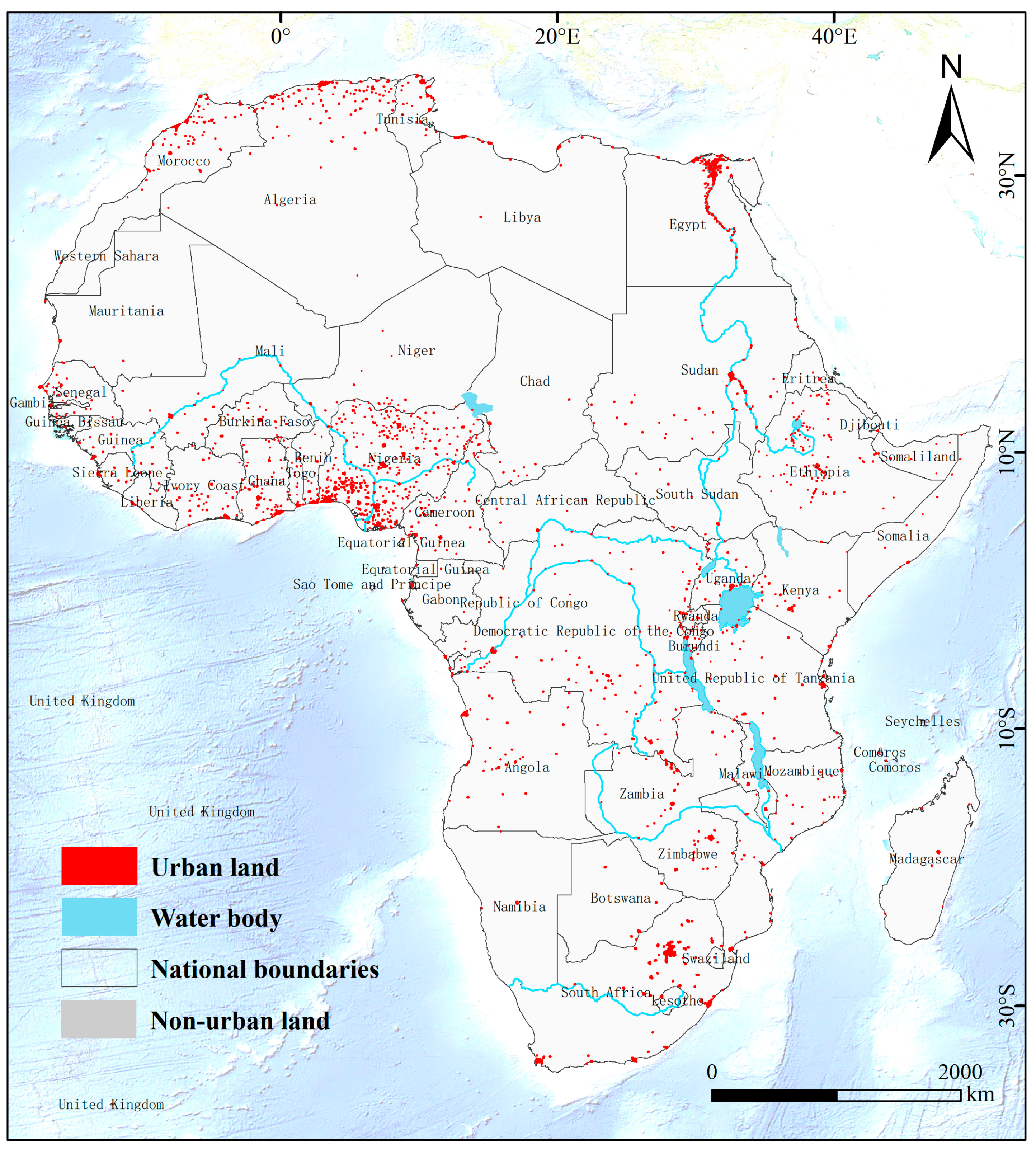
2.1. Study Area

As the second largest continent in the world, Africa has a rich and diverse geographical environment, culture, and economic form. This study covers all African countries (regions), which have a vast land use area and geographically span multiple climate zones such as tropical, subtropical, and temperate zones, including vast deserts, dense tropical rainforests, vast grasslands, and numerous rivers, lakes, and other natural landscapes. The level of economic development in Africa varies greatly among different countries. There are both emerging economies with rapid economic growth and underdeveloped countries facing many development challenges. In terms of urbanization, Africa as a whole has been in a stage of rapid urbanization in recent years, with a large number of people migrating from rural areas to cities and the size of cities continuing to expand. For example, in populous countries such as Nigeria and Egypt, their major cities such as Lagos and Cairo have seen a sharp increase in population in the past few decades, and the demand for urban land has continued to rise. We selected 266 major cities in Africa as the research objects of future urban expansion characteristics. In order to facilitate readers’ identification, we used ArcGIS to highlight all urban land in the study area in 2020 (Figure 1).

2.2. Data Sources

The data sources of this study are extensive. The statistics on the urban land area, population, and gross domestic product (GDP) of various countries over the years are derived from the Food and Agriculture Organization of the United Nations (FAO). Future population data and Purchasing Power Parity (PPP) data for different countries are obtained from the SSP database (https://tntcat.iiasa.ac.at/SspDb (accessed on 15 January 2025)). Land use data are sourced from the European Space Agency (ESA) (http://www.esa-landcover-cci.org/ (accessed on 15 January 2025)).
To conduct more precise simulation analyses using the FLUS model, the study selected 11 types of data from four dimensions—land use, social, economic, and environmental—as driving factors for the model. The detailed information relating to these data is shown in Table 1. The reasons for selecting each factor are as follows:
Land Use (A): The 2015 land use data (A1) with a resolution of 1 km from the European Space Agency (ESA-CCL) (http://www.esa-landcover-cci.org/ (accessed on 15 January 2025)) are used to provide the initial land cover conditions, which serve as the basis for simulating future land use changes. These data are crucial for understanding the starting point of land use transformation [29]. The distance to the airport (A2) (1 km in 2015) is selected because it reflects the accessibility of air transportation in a region, which has an impact on urban development and economic activities. Previous studies on urban development have shown that areas close to airports often have more development opportunities and higher land values [25].
Social Factors (B): The distance to roads (B1) (1 km in 2018), provided by the National Aeronautics and Space Administration (NASA) and the Socioeconomic Data and Applications Center, is an important factor. Good road connectivity can promote the movement of people, goods, and information and is crucial for urban expansion. As some studies have proven, areas with better road infrastructure often experience faster urban growth [30]. The distance to administrative centers (B2) (1 km in 2014), from the United Nations Department of Economic and Social Affairs, can reflect the impact of administrative management on urban development. Areas close to administrative centers may receive more policy support and resource allocation [31]. The distance to rivers (B3) (1 km in 2015), from the European Space Agency, is included because rivers can provide water resources and transportation functions, which have a significant impact on urban location and development [32].
Economic Factors (C): Population density (C1) (1 km in 2015) is a key indicator reflecting the concentration of population in a region. It is closely related to urban expansion because areas with higher population density typically have a greater demand for urban land. In many urban studies, population density is an important variable [25]. The Global Human Impact Index (C2) (0.5′ in 2005), provided by the Socioeconomic Data and Applications Center of the National Aeronautics and Space Administration (NASA), can measure the overall impact of human activities on the environment and is related to urban development patterns [33]. Although this is archival data, it still has a certain reference value. Despite significant changes that may have occurred since then, the data can provide historical context and relative reference for understanding long-term trends of human activities in the study area. In the case of scenario simulation requiring baseline data, historical data helps analyze the evolution of urban development and provides a reference for understanding the background of human activities in the study area, a view supported by the research of Gao et al. [34]. The nighttime light data (C3) (1 km in 2015), provided by the National Oceanic and Atmospheric Administration (NOAA), can reflect the intensity of human activities and the level of economic development. Areas with brighter nighttime lights usually indicate more prosperous economic activities and higher levels of urbanization, and have been widely used in urban studies [35].
Environmental Factors (D): Elevation (D1) (1 km in 1996), slope (D2) (1 km in 1996), and aspect (D3) (1 km in 1996) can affect the difficulty of urban construction and the suitability of land use. Steep slopes and high elevations may restrict urban expansion, while gentle slopes and suitable elevations are more conducive to development [36].

2.3. Shared Socioeconomic Scenarios (SSPs)

SSPs represent a new scenario framework introduced by the IPCC that integrates socio-economic scenarios and climate scenarios [28], covering five different scenarios: SSP1 focuses on sustainable development and the achievement of the Millennium Development Goals, while ensuring socio-economic progress, reducing the dependence on resources such as fossil fuels, promoting rapid development in low-income countries, and presenting an open, fair, and economically globalized world [37]; SSP2 depicts that the world will continue the development trajectory of recent decades, achieve certain results in the process of achieving development goals, and gradually reduce the dependence on fossil fuels, which is a medium development scenario [27]; SSP3 depicts the situation of local advancement or uneven development in the world, failing to achieve global development goals and relying heavily on resources such as fossil fuels, which is a scenario with a significant tendency towards deglobalization [38]; SSP4 shows a situation of extremely uneven development within and between countries, with a small number of wealthy groups generating the vast majority of emissions, which is a scenario facing severe adaptation challenges [39]; SSP5 focuses on addressing mitigation challenges, and is a conventional development scenario with large greenhouse gas emissions caused by rapid economic development [40].

2.4. Prediction Model of Urban Land Area in Africa

In this study, we selected the least squares dummy variable (LSDV) regression model to predict changes in urban land area in African countries. The LSDV regression model can quantify the impact of various socio-economic factors (such as per capita GDP, urbanization rate, etc.) on urban land area. By incorporating these factors as independent variables into the model, we can estimate their relative contributions to changes in urban land area, thereby providing a solid basis for understanding the drivers of urban expansion in Africa [41]. Moreover, the model can predict future urban expansion trends based on historical data. By introducing time-series data (such as data from 1993 to 2020), the model can capture the long-term trends and relationships between urban land area and socio-economic indicators, thus providing a scientific basis for future urban planning [42]. It is worth noting that our data cover the time series from 1993 to 2020, and the LSDV regression model performs well in handling such data. It can capture the dynamic relationship between urban land area and socio-economic indicators, thereby providing predictions for future urban expansion [43]. In addition, the LSDV regression model can simultaneously consider the impact of multiple independent variables (such as GDP, urbanization rate, etc.) on the dependent variable (urban land area). This multivariate analysis capability allows the model to more comprehensively reflect the complexity of urban expansion [41]. The LSDV regression model also provides statistical significance test results, which help assess the contribution of different factors to urban expansion. This statistical rigor ensures the reliability and credibility of the research results [42]. Moreover, the model has high flexibility and can adapt to different types of data structures and research objectives. For example, by introducing dummy variables, the unique characteristics of different countries or regions can be considered, thereby improving the accuracy and relevance of the model [43].
In summary, the LSDV regression model is an appropriate and effective tool for analyzing urban expansion in Africa. Based on the socio-economic data of African countries and urban land area data from 1993 to 2020, we constructed a regression model using the least squares dummy variable (LSDV) regression method in the Stata 18.0. The model sets the per capita urban land area (B) as the dependent variable, taking GDP per capita (G) and urbanization rate (P) as independent variables. In order to highlight the differences between African countries, a regional dummy variable (Z, generally with a value of 0 or 1) is introduced to reflect the different attributes of the variables. For an independent variable with n categorical attributes, one of the categories is selected as a reference to generate n-1 dummy variables. By inputting the GDP per capita (G) and urbanization under different shared socioeconomic scenarios (SSPs), The rate (P) data can be used to estimate the urban land area of African countries under different scenarios.
B = β 0 + β 1 × G r , t + β 2 × P r , t + i = 1 n a i × Z r , t + ε r , t
In the above formula, ε and β 0 represent the error term and intercept term, respectively, r refers to the countries in Africa, and t represents the year.

2.5. FLUS Model

The FLUS model uses an artificial neural network model to extract cells from the land use data of the first phase and related driving factors such as social, economic and environmental factors (such as topography, GDP, population density, and night lights), and converts them into the development probability of various land use types. At the same time, the inertia coefficient and competition mechanism are used to present the interaction and competition between urban and non-urban land in the dynamic simulation process. In addition, the model combines factors such as suitability probability, restrictive development conditions and future total land demand to simulate the spatial distribution of land use under specific scenarios in the future, effectively avoiding the limitations of traditional cellular automata in terms of cell morphology and neighborhood rules.

2.6. African Urban Expansion Indicators

We analyze the process and pattern characteristics of future urban expansion in Africa by selecting the urban expansion index ( I ) and population density. Among them, I represents the difference between the growth rate of urban land area ( γ ) and the growth rate of urban population ( α ), which is used to reflect a period of the degree of expansion of urban land over time; population density is expressed as the ratio of urban population to urban land area.
α ( t 1 , t 2 ) = [ ( A t 1 A t 2 ) 1 t 2 t 1 1 ] × 100 %
γ ( t 1 , t 2 ) = [ ( R t 1 R t 2 ) 1 t 2 t 1 1 ] × 100 %
I ( t 1 , t 2 ) = α ( t 1 , t 2 ) γ ( t 1 , t 2 )

3. Results

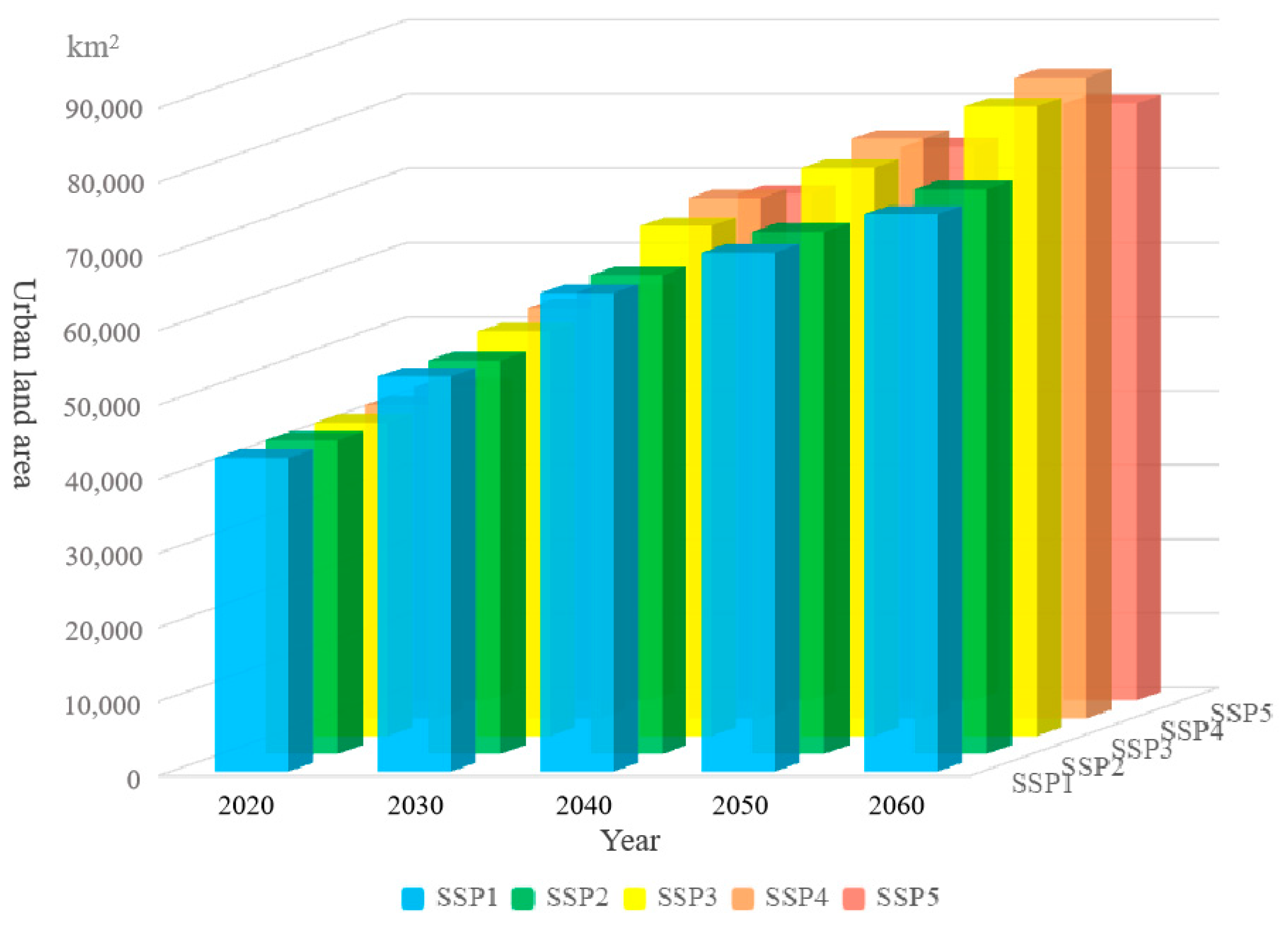
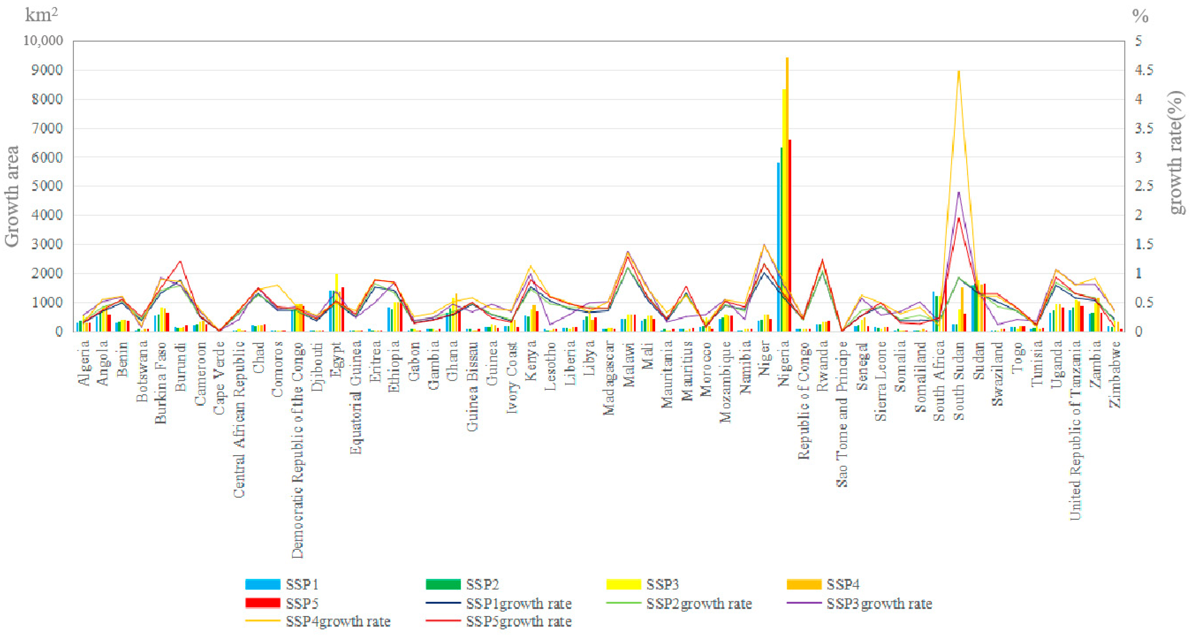
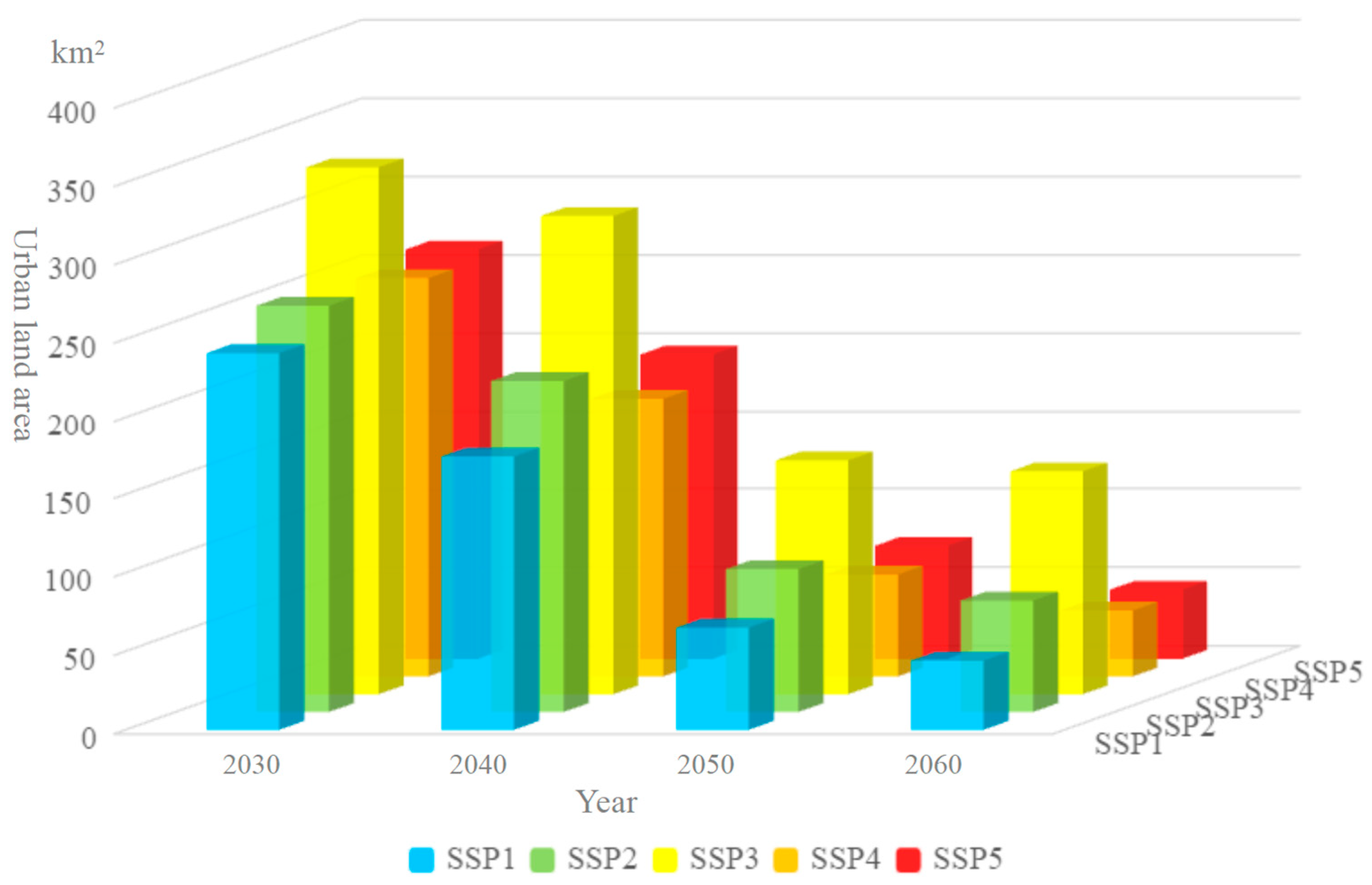
3.1. Change of Urban Land Area in African Countries Under the SSPs Scenario

In order to explore the spatial-temporal differences of urban land growth in African countries, we conducted a detailed analysis of the change of urban land area in different SSPs scenarios during the period 2030–2060.
From the overall data (Figure 2), the urban land area in Africa showed a continuous growth trend during the time period of 2030–2060. In the SSP1 scenario, In 2020, the urban land area is 42,272 km2, By 2030, the annual growth increased to 53,249 km2, Was further increased to 64,525 km2 in 2040, To 69,960 km2 in 2050, To 2060, the annual growth is to 75,079 km2; In the SSP2 scenario, The area of the corresponding years is 42,272 km2, 52,997 km2, 64,508 km2, 70,345 km2 and 76,132 km2; In the SSP3 scenario, 42,272 km2, 54,547 km2, 68,797 km2, 76,604 km2 and 84,863 km2 respectively; The SSP4 scenario is 42,272 km2, 55,316 km2, 70,141 km2, 78,112 km² and 86,397 km2; SSP5, the scenario is 42,272 km2, 55,031 km2, 68,343 km²2, 74,634 km2 and 80,485 km2.
We further observe the specific data of each country (Figure 3 and Figure 4). For example, Nigeria, which has a relatively prominent growth in urban land area, increases by 2853 km2 from 2030 to 2040, 1491 km2 from 2040 to 2050, and 1459 km2 from 2050 to 2060 under the SSP1 scenario. Its growth area is relatively high among African countries. This significant urban expansion in Nigeria can be attributed to a variety of factors. First, Nigeria has a large population base. Second, the large and growing population creates a natural impetus for people to seek better living conditions and opportunities in urban areas [44]. Additionally, rapid economic development in recent years has played a key role. The growth of industries such as oil, manufacturing, and services has created a large number of job opportunities in cities. As an important oil-producing country in Africa, Nigeria’s oil industry occupies a pivotal position in its economic and urbanization processes. The development of the oil industry has led to the agglomeration of related upstream and downstream industries in cities, attracting a large number of people to migrate to cities in search of employment [44]. For example, in areas of Nigeria rich in oil resources, the development of the oil industry has led to the establishment of a large number of related service and manufacturing enterprises in urban centers, attracting a large influx of labor. A study by Obi-Ani and Isiani on the city of Onitsha shows that the expansion of oil-related industries has significantly changed the city’s population structure and economic landscape, with a large number of workers attracted by job opportunities converging from surrounding areas [45]. The oil industry has always been the main driving force for Nigeria’s economic development and urbanization. In addition, studies have found that urban economic growth driven by the oil industry is an important factor in attracting internal migration, further promoting urban expansion and development [46]. Climate change has also had an impact on population migration in Nigeria [47]. With climate change leading to more extreme weather events and declining agricultural productivity in some rural areas, farmers are increasingly forced to abandon agricultural activities and move to cities in search of alternative livelihoods [48]. Studies have shown that there is a clear trend of rural–urban migration in areas of Nigeria affected by drought and flooding [49]. In addition, the influx of foreign investment should not be overlooked. The cheap labor force in Nigerian cities has attracted foreign investors to set up factories. For example, in the textile and manufacturing sectors, foreign companies have established production facilities in Lagos and other major cities, further promoting urban expansion [49].
Another example is Ethiopia. Under the SSP3 scenario, it increases by 470 km2 from 2030 to 2040, 260 km2 from 2040 to 2050, and 287 km2 from 2050 to 2060. Its growth trend is also quite significant. This is due to the country’s continued economic growth and accelerated urbanization process. In recent years, Ethiopia has experienced steady economic growth driven by sectors such as agriculture, manufacturing, and infrastructure development [50]. The government’s investment in infrastructure projects, including roads, railways, and energy facilities, has not only improved connectivity but also stimulated the development of urban areas along these corridors [51]. For example, the construction of the Addis Ababa–Djibouti Railway has led to the growth of urban settlements in surrounding areas [52]. The expansion of industrial parks and manufacturing zones, such as the Hawassa Industrial Park, has attracted an increasingly large number of workers from rural areas [53].
The growth of urban land area in some countries under certain scenarios presents unique stage characteristics. Take South Africa as an example. In the SSP1 scenario, it increases by 789 km2 from 2030 to 2040, but the growth rate is significantly smaller from 2050 to 2060, with an increase of only 316 km2. Then, it increases by 251 km2 in 2060 compared with 2050. This can be attributed to several factors related to South Africa’s development context. Firstly, after experiencing rapid urbanization in the early stages, urban land expansion has gradually slowed down with the adjustment of economic structures [25]. As economic development progresses, there is a shift from a primary focus on extensive urban expansion to a more balanced approach that considers the quality and efficiency of urban growth [54]. This trend aligns with the general pattern of urban development in many regions, where the demand for additional urban land may decrease as the economy matures, while the emphasis on optimizing existing urban areas increases [44,55]. Secondly, changes in land use policies have also played a key role. South Africa has implemented policies to better manage urban growth and protect agricultural and ecological land [56]. For example, in some African countries, urban planning policies have been established to guide the rational use of land [57]. In South Africa, the government has adopted similar policies to control urban expansion. The government could implement zoning regulations or land conservation measures [58]. In some regions, specific areas may be designated for different uses, such as industrial, commercial, and residential purposes, thereby restricting the arbitrary expansion of urban land. These policy changes often have a significant impact on the speed of urban land expansion. By regulating the supply and use of land, the government can influence the pace and pattern of urbanization, ensuring that it is consistent with broader social, economic, and environmental objectives. This is an important aspect of sustainable urban development, as it helps to balance the need for urban growth with the protection of natural resources and the provision of basic services [59].
From the perspective of growth rate, Burkina Faso has a higher urban land growth rate under the SSP1 scenario, reaching 0.648521. This can mainly be attributed to the fact that Burkina Faso is in a stage of rapid urbanization [60]. The population of Burkina Faso’s major cities is increasing, driven by natural growth and rural–urban migration, leading to strong demand for urban land infrastructure and industrial development [61]. Due to the lack of comprehensive urban planning policies and land management strategies, it is difficult to effectively control the expansion of urban land. In contrast, Morocco’s growth rate under the SSP5 scenario is only 0.055344, which is relatively slow. This is related to the country’s relatively mature urban planning and land use management system. Relevant studies have shown that the Moroccan government has been implementing measures to manage urban growth, such as promoting the development of satellite cities and improving land use efficiency in existing urban areas [62]. In addition, the Moroccan government has also focused on protecting historical and cultural areas, which has limited the extent of urban expansion. Compared with Burkina Faso, Morocco’s economic structure is more diversified, which may also lead to a slowdown in urban land growth rates. Morocco’s service and tourism industries play an important role in the economy, and these sectors do not require extensive land expansion like heavy industry or large-scale manufacturing [63].
In general, the growth of urban land area varies among African countries under different SSP scenarios, which is closely related to various factors such as population growth, economic development level, policy orientation, and resource endowment [64].

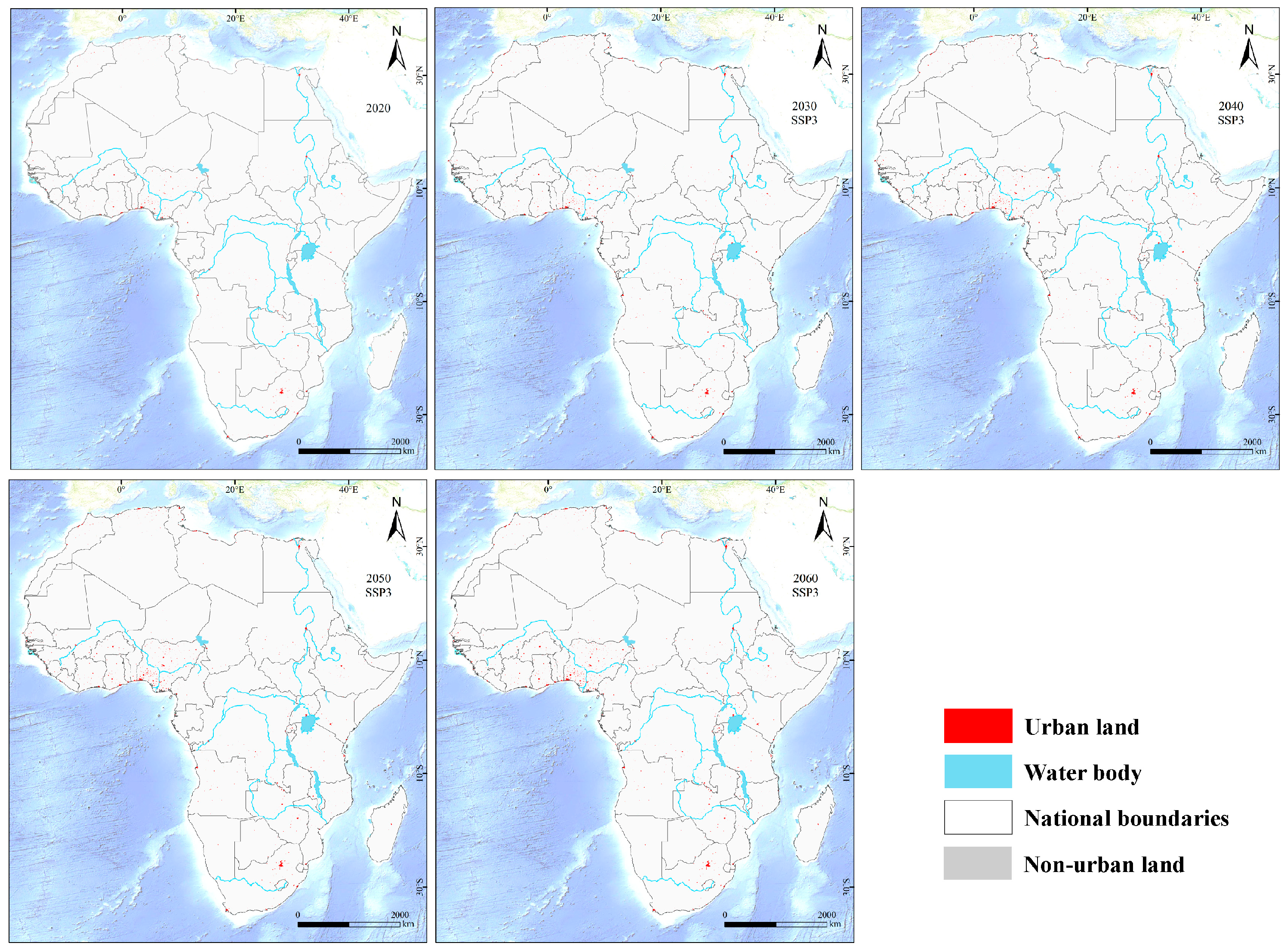
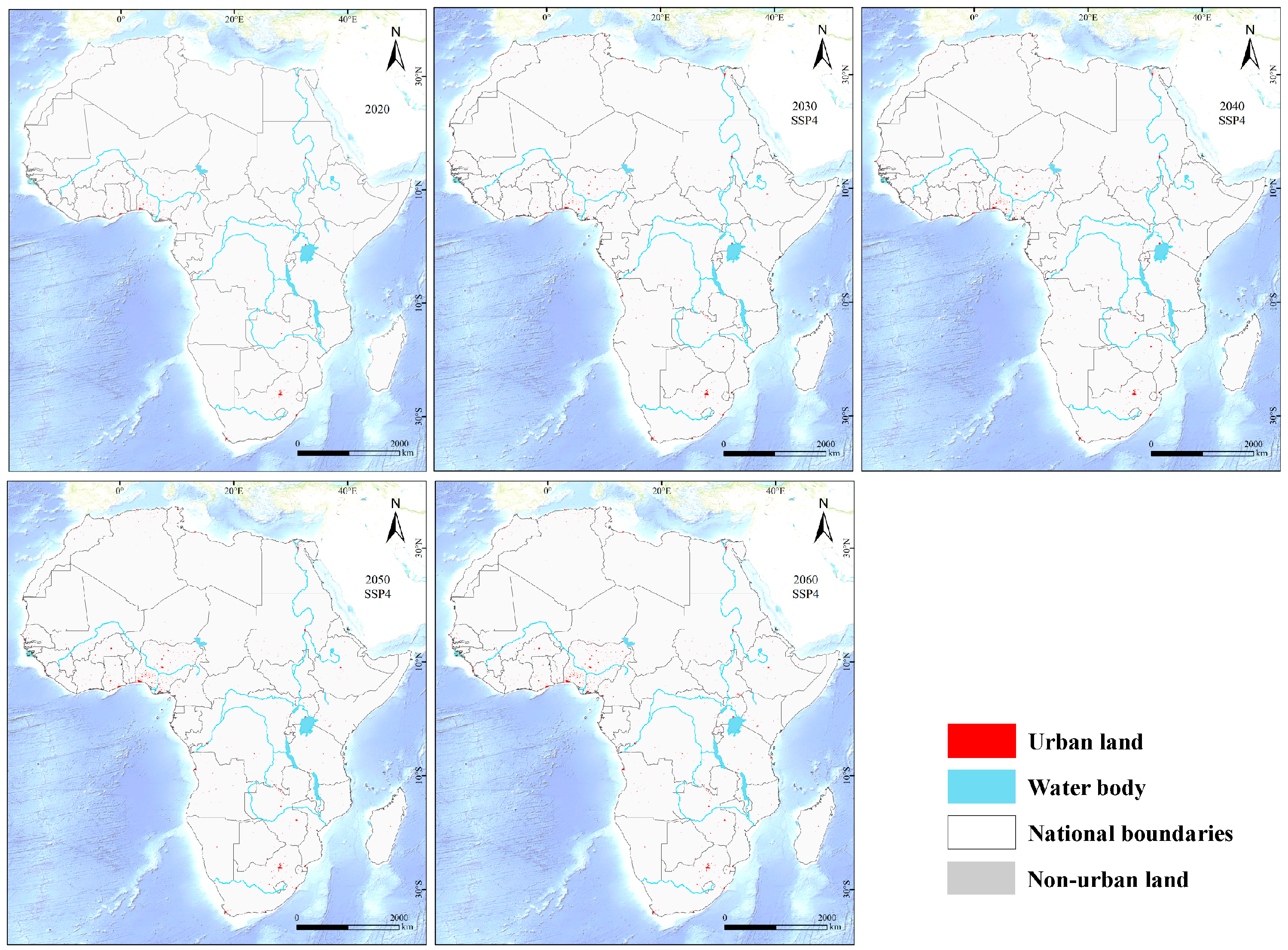
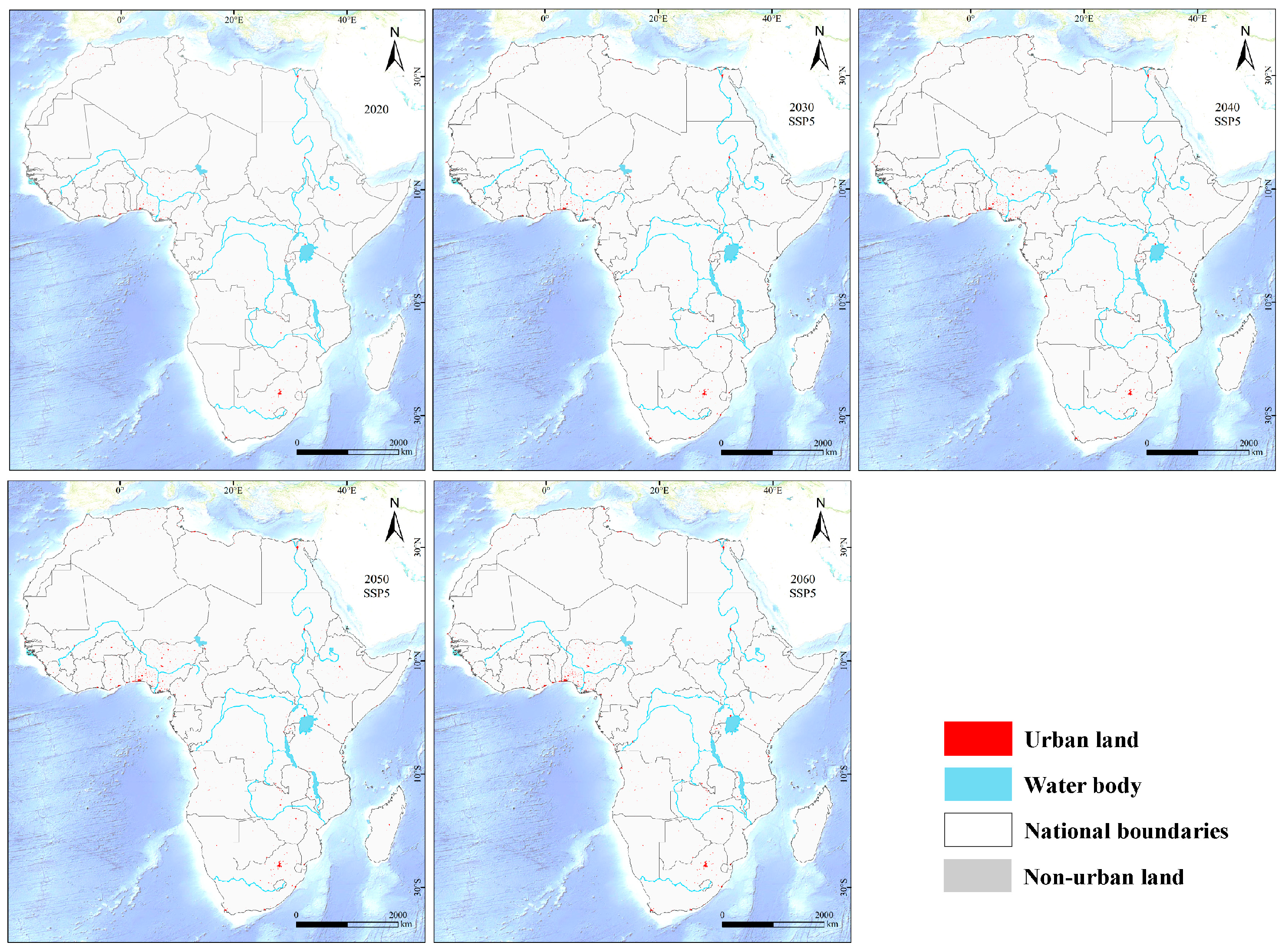
3.2. Spatial Distribution of Future Urban Land Use in African Countries Under the SSP Scenario

Under the SSP1 scenario, full consideration is given to achieving the Sustainable Development Goals (SDGs) and the Millennium Development Goals (MDGs) [65]. This scenario is committed to achieving sustainable development and ensuring social and economic progress, while reducing the dependence on resources such as fossil fuels. In this scenario, an emphasis is placed on a sustainable economic growth model, focusing on the efficient use of resources and environmental protection, and actively promoting the development and application of renewable energy to reduce the reliance on traditional fossil fuels. As shown in Figure 5, overall, urban land in Africa shows a relatively orderly expansion trend.
In some countries with a good economic foundation and active participation in global development, urban expansion is more obvious [66]. For example, in South Africa, the urban land area will increase from 5678 km2 in 2020 to 8765 km2 in 2060. This is because South Africa can fully utilize its own resource and technological advantages to attract more investment and industrial development in this open and equal development environment, thereby promoting urban expansion. Its industrial upgrading and economic diversification prompt cities to need more land for commercial, industrial, and residential purposes, which further accelerates the process of urban expansion [67]. In addition, South Africa’s urban expansion is also influenced by global development trends and domestic economic policies. Against the backdrop of globalization, South Africa actively participates in international economic cooperation, promotes the upgrading of domestic industries and economic diversification through attracting foreign investment and technology transfer [68]. At the same time, the South African government has also formulated a series of economic policies, such as infrastructure construction and tax incentives, to provide strong support for urban expansion [69]. These measures not only promote South Africa’s economic growth but also drive the process of urban expansion. With the increase in the urban population and the continuous development of the economy, South Africa’s cities need more land to meet the demands of commerce, industry, and housing, which further promotes urban expansion [70].
For low-income countries, such as Burkina Faso, the urban land area will increase significantly from 987 km2 in 2020 to 3456 km2 in 2060. This is because under the SSP1 scenario, it can obtain more international aid and cooperation opportunities, domestic infrastructure construction will be accelerated, the industrialization process will be promoted, and a large number of rural population will move to cities, which will promote the rapid expansion of urban land.
SSP2 describes a scenario in which the world maintains the development pattern of the past few decades, making certain progress in achieving development goals and gradually reducing the dependence on fossil fuels [27]. This is a medium development scenario. In SSP2, economic growth is relatively stable, but it also faces some challenges, such as resource shortages and environmental pollution. As can be seen from Figure 6, the expansion rate of urban land in African countries is relatively stable.
For traditional regional powers like Egypt, the urban land area increases from 7890 km2 in 2020 to 11,234 km2 in 2060. Relying on its existing development foundation and relatively stable economic growth model, Egypt gradually promotes urbanization while maintaining its original development trajectory. In some small- and medium-sized countries, such as Benin, urban land area increases from 567 km2 in 2020 to 1012 km2 in 2060.
Under the SSP2 scenario, there are significant differences in urban land expansion across different regions in Africa. North African countries, such as Egypt, with a stronger economic base and an industrial structure dominated by tourism and manufacturing, experience faster and larger-scale urban land expansion [71]. In contrast, sub-Saharan African countries like Benin, with weaker economic foundations and agriculture-based economies, have slower and smaller-scale urban land expansion [72]. Additionally, the construction and layout of transportation infrastructure have also had a significant impact on urban land expansion. For example, the construction of the Addis Ababa–Djibouti Railway in Ethiopia has significantly propelled urban expansion along the railway [52]. Under the SSP2 scenario, urban land expansion in African countries is significantly influenced by the structure of population growth. Africa’s population growth is dominated by young labor forces, who are more inclined to migrate to large cities in search of employment opportunities and better living conditions. This migration preference drives urban land expansion, especially in large cities. For example, cities like Cairo and Alexandria in Egypt have higher demands for urban land due to the influx of young labor forces [73]. In contrast, countries like Benin, with relatively slower population growth and a predominantly rural population, rely more on natural growth and infrastructure development to drive urban expansion [74]. Additionally, according to the World Population Prospects, the trend of population aging in Africa’s urbanization process is relatively low, meaning that urban land expansion is more driven by the demands of the young population [75]. Meanwhile, under this scenario, the economic development models of African countries have also had a significant impact on urban land expansion. For example, Egypt’s economic growth model, dominated by tourism, agriculture, and manufacturing, creates new demands for urban land. In particular, the development of the tourism industry requires more land for hotels, transportation, and entertainment facilities, thus driving urban land expansion [76]. For countries like Benin, with weaker economic foundations and single industrial structures, urban expansion relies more on the slow development of traditional industries and the gradual improvement of infrastructure [77]. Additionally, resource-based economies such as Nigeria, where the oil industry plays a significant role, also have a notable impact on urban land expansion. The layout and development of various segments of the oil industry in cities, especially the construction of oil processing and transportation facilities, further drive urban land expansion [45]. At the same time, environmental factors may also have an impact on urban land expansion under this scenario. For example, extreme climate events and sea-level rise caused by climate change have a more significant impact on coastal cities, while inland cities are more affected by droughts and floods. These environmental issues prompt population migration to cities, further increasing the demand for urban land [78]. Additionally, according to the IPCC report, African countries’ relatively weaker capacity to address climate change further exacerbates the pressure on urban land expansion [79].
SSP3 depicts a scenario of partial or inconsistent global development, with a failure to achieve global development goals and a high dependence on fossil fuels and other resources [38]. In this scenario, various reasons lead to unbalanced and inconsistent development across countries. Some regions may fail to achieve development goals effectively due to political, economic, and social issues. Meanwhile, the high dependence on fossil fuels also exerts significant pressure on the environment. As can be seen from Figure 7, there is a clear differentiation in urban expansion among African countries. In some resource-rich countries that rely on fossil fuel industries, such as Libya, urban land area increases from 4567 km2 in 2020 to 7891 km2 in 2060. However, for some resource-poor countries that lack international cooperation opportunities, such as Somalia, urban land area will grow slowly between 2020 and 2060, increasing only from 345 km2 to 456 km2.
Under the SSP3 scenario, there are significant differences in urban land expansion across different regions in Africa. Resource-rich countries in North Africa, such as Libya, experience faster and larger-scale urban land expansion due to their stronger economic foundations and dependence on fossil fuel industries [80]. In contrast, resource-poor countries in sub-Saharan Africa, such as Somalia, have slower and smaller-scale urban land expansion due to weaker economic foundations and a lack of international cooperation opportunities [81]. These regional differences reflect the impact of economic development levels, resource endowments, and international cooperation opportunities on urban land expansion. In this scenario, differences in population growth structures across African countries also significantly affect urban land expansion. For example, resource-rich countries like Libya, assuming internal peace and the avoidance of civil wars, are likely to experience faster economic development due to abundant oil and natural gas resources. This attracts a large influx of young labor into cities, driving urban land expansion [82]. In contrast, resource-poor countries like Somalia, with weaker economic foundations, slower population growth, and a predominantly rural population, rely more on natural growth for urban expansion [83]. These differences in population structure lead to significant variations in the speed and scale of urban land expansion. The economic development models of African countries also play an important role in urban land expansion under this scenario. Resource-rich countries, which rely heavily on fossil fuel industries, have relatively single economic structure, urban expansion mainly around resource development and processing industries [84]. However, this resource-dependent economic model lacks diversification and is vulnerable to fluctuations in international energy market prices. In contrast, resource-poor countries like Somalia, lacking an industrial base, rely more on traditional agriculture and fisheries for urban expansion, resulting in slower expansion rates [85].
SSP4 describes a scenario of highly uneven development both within and between countries, where a small number of wealthy groups generate the majority of emissions, posing significant adaptation challenges [39]. In SSP4, the widening gap between the rich and the poor exacerbates social inequality. As shown in Figure 8, the imbalance of urban expansion in African countries is very prominent.
In some countries with developed economies and where resources are concentrated in the hands of a few groups, such as Nigeria, the land area in urban core areas increases significantly, from 9876 km2 in 2020 to 15,678 km2 in 2060. This is because industrial development and investment led by a small number of wealthy groups are mainly concentrated in urban centers, driving the rapid expansion of urban core areas [86]. These industries are often capital-intensive and high-emission, further exacerbating the imbalance in urban development [87]. For the vast rural areas and some marginal areas, urban land has hardly increased or even shrunk. For example, in some remote areas of Niger, the urban land area will decrease from 234 km2 in 2020 to 189 km2 in 2060.
Under the SSP4 scenario, urban land expansion in African countries is influenced by a variety of factors, including economics and population dynamics. The imbalance in economic development affects urban land expansion to some extent. Regions with more developed economies tend to attract more investment and population inflows, thereby driving urban land expansion. For example, cities with abundant natural resources or important ports may experience rapid expansion due to the development of trade and industry [88]. As the economy develops, the adjustment of industrial structures also impacts urban land expansion. The rise of industries such as manufacturing and services may require more land for the construction of factories, office buildings, and commercial facilities, further fueling urban land expansion [89]. However, economic factors do not always promote urban land expansion. In some economically underdeveloped regions, urban development is slow and urban land expansion is relatively limited due to a lack of capital and technology. Moreover, economic instability and financial crises can also lead to stagnation or a reversal in urban land expansion [90]. Population growth is one of the key drivers of urban land expansion in African countries. Under this scenario, Africa’s population is projected to continue growing rapidly. As the population increases, cities require more housing, infrastructure, and public services, which inevitably leads to urban land expansion. In particular, the concentration of populations in large cities makes urban land expansion more pronounced [91]. In addition, population movement also impacts urban land expansion. The migration of rural populations to cities is one of the main features of urbanization in Africa. A large influx of rural residents into cities in search of better living conditions and employment opportunities further intensifies the pressure on urban land. Meanwhile, international migration may also have an impact on urban land expansion in some African countries [92].
SSP5 is not a business-as-usual scenario; it focuses on addressing mitigation challenges and is characterized by high energy and resource intensity. Rapid economic development in this scenario leads to significant greenhouse gas emissions [40]. While economic growth is swift under SSP5, it also brings substantial environmental pressures. As shown in Figure 9, urban land use in African countries is generally expanding rapidly.
Taking Kenya as an example, the urban land area will grow rapidly from 3456 km2 in 2020 to 8901 km2 in 2060. Under the SSP5 scenario, Kenya’s economy develops rapidly, and large-scale industrialization and urbanization are accelerating. Emerging industries continue to emerge, attracting a large number of people from rural areas to cities. In order to meet the needs of population residence, industrial development, and infrastructure construction, urban land has expanded rapidly. At the same time, this rapid development is also accompanied by tremendous pressure on the environment, such as large-scale land development and energy consumption leading to increased greenhouse gas emissions.
Under the SSP5 scenario, urban land expansion in African countries is the result of multiple factors working together. First, SSP5 is an energy- and resource-intensive scenario where rapid economic development leads to significant greenhouse gas emissions. In this scenario, African countries experience swift economic growth, which dramatically increases the demand for energy and resources. On the one hand, this drives the development of industries and the urbanization process; on the other hand, it exerts substantial environmental pressure. For example, large-scale energy development and consumption can lead to the degradation of land resources and the deterioration of the ecological environment, which in turn affects urban land expansion [40]. Rapid economic growth is a key driver of urban land expansion in African countries. As the economy develops, new industries continue to emerge, attracting a large rural population to move to cities. To meet the needs of population housing, industrial development, and infrastructure construction, urban land expands rapidly. The case of Kenya demonstrates that under this scenario, economic growth creates more job opportunities and business prospects, drawing a large population into cities [93]. In addition, economic development also prompts cities to require more land for commercial, industrial, and residential purposes. For example, in South Africa, industrial upgrading and economic diversification drive cities to need more land for commercial, industrial, and residential purposes, further accelerating the process of urban expansion [67]. Under the SSP5 scenario, population growth is also an important factor in urban land expansion in African countries. With economic development and improved living standards, the population growth rate in African countries is relatively high. A large rural population moves to cities, leading to a rapid increase in urban population. To meet the housing needs of the population, cities need to continuously expand land. For example, in some African countries, the growth rate of urban population far exceeds the construction speed of urban infrastructure, resulting in problems such as urban traffic congestion and housing shortages. This further drives the expansion of urban land [91].
Since the area of urban land is relatively small in the total land area, in order to show the simulation results more clearly, we used focal statistical analysis in ArcGIS to obtain the amount of new urban land in Africa within a radius of 10 km (Figure 10). The figure shows the increase in new urban land in cities within a radius of 10 km in Africa from 2020 to 2060 under the five scenarios of SSP1–SSP5, reflecting the spatial characteristics of urban expansion in Africa under different scenarios, especially the representative areas composed of Nigeria (the core country), Togo, Benin, Cameroon, etc., in West Africa, which show obvious differences under different scenarios.
Under the SSP1 scenario, urban land expansion in some regions of Africa is relatively significant. For example, in Nigeria, some areas have a large amount of new urban land, with colors ranging from dark red to purple, indicating more pronounced urban land expansion within a radius of 10 km. This is particularly evident around major cities like Lagos. This phenomenon can be attributed to the emphasis on sustainable development and global cooperation in the SSP1 scenario. In this scenario, Nigeria may gain more resources and technological support, thereby promoting the urbanization process, especially in regions with a strong economic base and convenient transportation, where urban expansion is more noticeable [94]. In contrast, urban land expansion in Togo, Benin, and Cameroon is relatively moderate, with colors mostly yellow and orange, indicating a slower pace of urban expansion in these countries compared to Nigeria. This may be due to Nigeria’s development spillover effect and their own benefits from sustainable development cooperation. Urban expansion under the SSP1 scenario may also be influenced by other factors. For example, population growth and economic development drive urban expansion. As people pursue better living conditions, cities become centers of attraction, leading to an increase in urban land [95]. In addition, government policies and investments may also impact urban expansion. Under the SSP1 scenario, which emphasizes sustainable development, governments may increase investment in infrastructure and urban planning to promote orderly urban development.
Under the SSP2 scenario, urban land expansion is relatively stable and evenly distributed. Representative regions such as Nigeria, Togo, Benin, and Cameroon all show a moderate trend in urban land expansion. The colors around some cities in Nigeria are mostly yellow and orange, indicating a moderate amount of new urban land. Togo, Benin, and Cameroon also show similar colors, indicating that urban expansion in these countries is advancing at a relatively stable pace under this medium development scenario, without significant fluctuations in large-scale urbanization or urban expansion. The differences in urban land expansion among countries are relatively small [92]. The stable expansion under the SSP2 scenario may be the result of multiple factors working together. On the one hand, stable economic development provides a continuous driving force for urban construction. Under this scenario, countries may adopt a more balanced development strategy, focusing on the coordinated development of the economy, society, and environment. On the other hand, the role of urban planning and management cannot be ignored. Rational urban planning can guide orderly urban expansion and avoid problems caused by disorderly development [96].
Under the SSP3 scenario, urban land expansion shows significant differentiation. Nigeria, as a resource-rich country, has darker colors around its oil-producing regions, indicating a large amount of new urban land. Urban expansion is more pronounced around the Niger Delta and other oil-producing areas. This is because, under the scenario of deglobalization and high resource dependence, Nigeria continues to rely on the development of the oil industry, which drives urban expansion in surrounding areas [97]. In contrast, Togo and Benin, with relatively scarce resources and limited international cooperation, experience very slow urban land expansion, with lighter colors and little change in some areas. Cameroon, though having some resources, also faces slower urban land expansion under this scenario, forming a stark contrast with Nigeria. The differentiation under the SSP3 scenario reflects the importance of resource allocation and international cooperation. Resource-rich countries are more likely to rely on resource development to drive urban expansion, while resource-poor countries face greater development challenges. Moreover, the trend of deglobalization may lead to a reduction in international cooperation, further limiting development opportunities for these countries [98].
Under the SSP4 scenario, the imbalance in urban land expansion is further exacerbated. In Nigeria, regions around major cities like Lagos and Abuja have darker colors and concentrated ranges, indicating a large amount of new urban land within a 10 km radius. This is due to the highly unequal development within and between countries under the SSP4 scenario, where resources and development opportunities are concentrated in a few wealthy groups and large cities, leading to rapid urban land expansion around major cities in Nigeria [99]. However, most areas in Togo, Benin, and Cameroon have little urban land expansion, with only a few color changes around individual cities, indicating fewer development opportunities and urban expansion concentrated in a few areas in these countries, further widening the gap with Nigeria. The imbalanced development under the SSP4 scenario highlights the issue of socio-economic inequality. The rapid development of a few wealthy groups and large cities contrasts sharply with the stagnation in other regions, which may lead to increased social instability and resource allocation inequality [100]. At the same time, the lack of effective policy intervention and international cooperation may also perpetuate this imbalance.
Under the SSP5 scenario, urban land expansion in Africa is rapid overall. Representative regions such as Nigeria, Togo, Benin, and Cameroon all show varying degrees of rapid urban land expansion. The urban land expansion range in Nigeria further expands, with multiple areas in deep purple and red, indicating a large amount of new urban land within a 10 km radius. Togo, Benin, and Cameroon also show clear trends of urban expansion, with colors mostly dark yellow, orange, or even red, indicating that large-scale industrialization and urbanization under the conventional development scenario characterized by rapid economic development and significant greenhouse gas emissions lead to rapid urban land expansion in these countries over a broader area. However, Nigeria’s urban expansion scale and speed still lead in the region [101]. The rapid expansion under the SSP5 scenario may be an inevitable result of economic development and urbanization. As industrialization and urbanization progress, the demand for land continues to increase, leading to rapid urban land expansion. However, this rapid expansion also brings a series of challenges, such as environmental issues, resource shortages, and social inequality.
In general, urban expansion in African countries presents quite different characteristics under different SSP scenarios, which is closely related to factors such as the socio-economic development model, resource utilization mode, and degree of globalization set in each scenario.

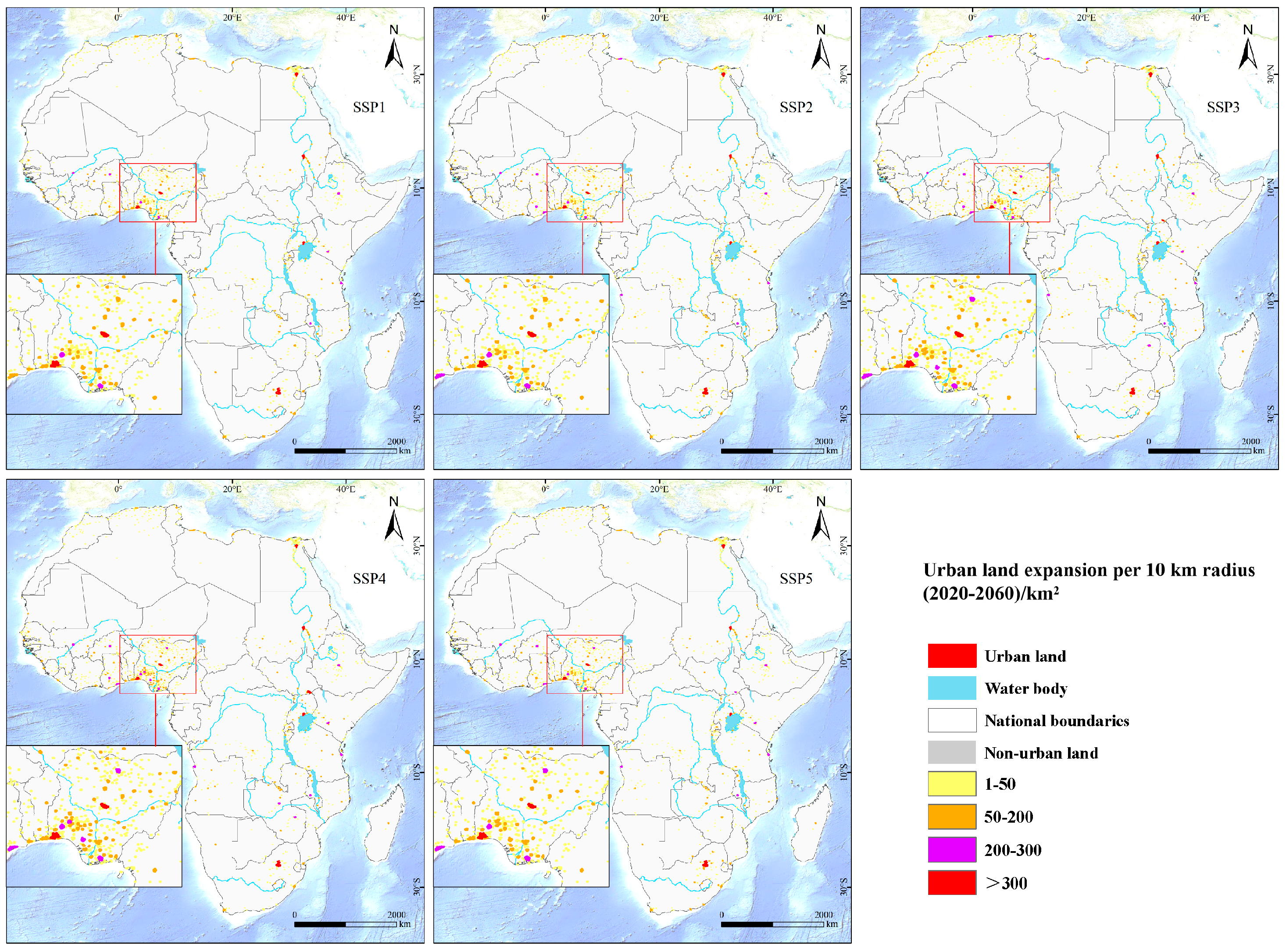
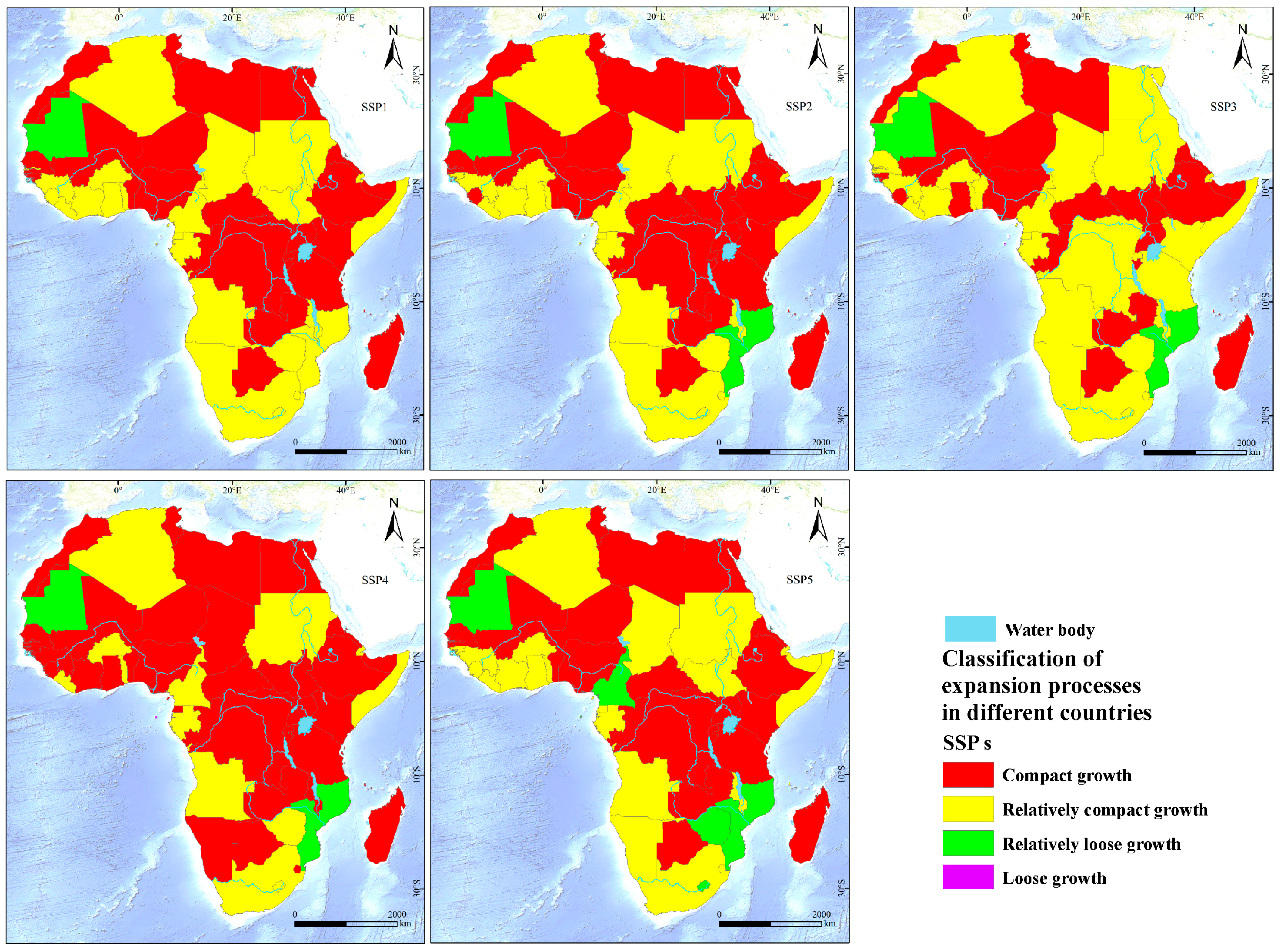
3.3. Expansion Characteristics of Cities in African Countries Under Different SSP Scenarios

In our study of urban expansion in African countries, we revealed their unique expansion characteristics based on the analysis under the SSP scenario. This study uses the expansion index I value as a key indicator to divide urban expansion characteristics into four categories: loose growth (I > 0.9), relatively loose growth (0 ≤ I ≤ 0.9), relatively compact growth (−0.9 ≤ I <0), and compact growth (I < −0.9) [102], and conducts an in-depth analysis of urban expansion in African countries (Figure 11).
From the overall data, under the SSP1 scenario, most African countries show a relatively consistent expansion trend. For example, Algeria’s I value is −0.207803, which is in a relatively compact growth range. This may be because the country has promoted economic development under this scenario, but it is more cautious in land use planning, focusing on the optimization and integration of existing urban areas, so that urban land growth and population growth are relatively coordinated, and there is no large-scale urban land expansion. Angola’s I value is −0.950516, which is in the compact growth category. The reason may be that the economic structure is still relatively dependent on specific industries under the SSP1 scenario, urban development is concentrated in the core area, and population growth is also mainly concentrated in these limited urban areas, resulting in relatively slow growth of urban land and a compact growth trend.
Compared with SSP1, SSP2 shows some new trends. In the SSP2 scenario, most countries still maintain a compact growth trend similar to SSP1, but some countries have also experienced changes to varying degrees. This may be because Ghana has adjusted its economic development path in this scenario, such as increasing investment in some emerging industries, attracting more people to flow into cities, thereby increasing the demand for urban land and accelerating the expansion rate. Botswana’s I value is −0.305012, which is still a relatively compact growth. This reflects that while maintaining a certain development speed, the country has better controlled the disorderly expansion of urban land, which may be due to its reasonable urban planning policies and relatively stable population growth model. In general, although the overall pattern in the SSP2 scenario is similar to that in SSP1, the new changes in some countries reflect the development differences under different scenarios.
Under the SSP3 scenario, urban expansion in African countries presents a complex situation. For example, Cameroon’s I value is −0.582311, which is in a relatively compact growth range. This may be because in the context of local development or inconsistent development, the development of some areas is restricted, urban expansion is concentrated in a few advantageous areas, and the overall urban land growth is relatively conservative. Looking at Libya, it presents a loose growth trend. This may be due to its economy being highly dependent on oil resources. Under the regional competition and deglobalization trend of SSP3, the fluctuation of the oil industry has a greater impact on urban development. Some areas have rapid urban land expansion due to resource development or trade activities, while other areas have slow development, thus forming the complexity of overall urban expansion.
In the SSP4 scenario, the compact growth characteristics of urban expansion are further highlighted. It can be clearly seen from the figure that the number of red areas has increased. For example, the I value of South Africa is 2.066804, which represents a loose growth trend. This shows that in the scenario of highly uneven development within and between countries, some parts of South Africa may form a loose growth pattern due to the concentrated investment and development of a small number of wealthy groups, rapid expansion of urban land, and relatively lagging population growth. The I value of Burundi is −3.779169, which represents a compact growth state. This may be due to its disadvantage in resource allocation and access to economic development opportunities, which severely restricts urban development and makes it difficult for urban land to expand effectively under the pressure of population growth.
Under the SSP5 scenario, the background of rapid economic development has led to significant urban expansion in some countries. Nigeria’s I value is −0.978423, which is in the compact growth range. Although the economy has developed, the rapid population growth may not keep up with the construction and planning of urban infrastructure, resulting in relatively slow growth of urban land and compact growth. Mauritius’s I value is 0.224376, showing loose growth. This may be due to its active promotion of urban modernization and industrial upgrading during its rapid economic development, which has attracted a large number of people to flow into cities, but the urban land planning is relatively loose, resulting in a faster growth rate of urban land.
In general, under different SSP scenarios, the urban expansion characteristics of African countries are different. This is not only closely related to the economic development level and population growth trend of each country, but also deeply influenced by factors such as the socio-economic development model, resource utilization mode, and degree of globalization set by the SSP scenario.

4. Discussion

4.1. Comparative Analysis of Urban Land Growth in African Countries Under Different SSP Scenarios

In the study of urban land growth changes in African countries, different SSP scenarios show different urban land growth patterns. The reasons behind this are multifaceted and complex. We believe that this is related to economics, resources, policy planning, and population factors being closely related.
The patterns of urban land expansion in Africa vary significantly under the five SSP scenarios, primarily due to differences in economic development, resource utilization, and policy assumptions across these scenarios. Under the SSP1 scenario, urban land expansion is characterized by sustainable development and global cooperation. For example, South Africa, with increased international investment, especially in infrastructure construction and industrial upgrading, has seen steady growth in urban land. This scenario emphasizes investment in renewable energy and environmental technologies, driving related industrial development and attracting population aggregation, thereby promoting urban land expansion [27]. This scenario assumes a global shift towards sustainable development practices, resulting in balanced urban land expansion and moderate growth rates. In contrast, the SSP2 scenario follows a middle-of-the-road development path, with more stable urban land expansion in countries like Botswana. This scenario reflects historical development patterns, where urban land growth relies on natural economic growth and population movement, lacking the strong external driving factors present in the SSP1 scenario [103]. As a result, urban land expansion is slower and more stable. The SSP3 scenario is characterized by regional competition and deglobalization, leading to stark contrasts in urban land expansion. Resource-rich countries like Libya, with their dependence on the fossil fuel industry, experience significant urban land expansion, driving the development of urban infrastructure and related service industries [38]. In contrast, resource-poor countries with limited international cooperation, such as Somalia, see very slow urban land expansion, or even stagnation. The SSP4 scenario highlights extreme socio-economic inequality, with rapid urban land expansion in some regions of South Africa controlled by a few wealthy groups and large cities. This scenario leads to highly imbalanced urban land expansion, exacerbating urban–rural disparities and regional development imbalances [39]. Finally, the SSP5 scenario focuses on fossil fuel-driven economic development, resulting in significant urban land expansion. For example, Nigeria’s rapid industrialization and urbanization process has led to a large influx of rural populations into cities, increasing the demand for urban land [40]. This scenario assumes a continued reliance on fossil fuels, leading to high greenhouse gas emissions and significant environmental impacts. Overall, the differences in urban land expansion under these scenarios mainly stem from different economic growth models, resource utilization methods, and policy directions. For example, SSP1 and SSP2 emphasize sustainable and stable development, leading to moderate urban land expansion; SSP3 and SSP4 highlight resource dependence and inequality, resulting in a rapid expansion in resource-rich areas and stagnation in resource-poor areas. SSP5, driven by fossil fuels, leads to rapid urban land expansion but at the cost of environmental sustainability.
Considering economic, environmental, and policy factors comprehensively, we predict that urban land expansion in Africa will follow multiple paths, depending on the interaction of economic, demographic, policy, and environmental conditions. Under the sustainable development scenario (SSP1), urban land expansion will be more compact and efficient, driven by effective planning and green technology investment. In the middle-of-the-road development scenario (SSP2), urban land expansion will be moderate, reflecting stable economic growth and gradual urbanization. Under the resource-dependent and unequal scenarios (SSP3 and SSP4), urban land expansion will be highly imbalanced, with rapid expansion in resource-rich areas and stagnation in resource-poor areas. Finally, under the fossil fuel-driven scenario (SSP5), urban land expansion will be rapid but potentially unsustainable, with significant environmental impacts.

4.2. Comparison of This Study with the Studies in Other Regions

In the context of global urban development, by comparing the urban expansion in Africa with that in Europe, America, Asia, and other regions under different SSP scenarios, we can clearly find their similarities and differences and the underlying logic behind them. In the SSP1 scenario, Europe and America, such as the United States, with its strong scientific and technological research and development and abundant financial support, vigorously develop clean energy and intelligent transportation systems, and closely combine urban land growth with ecological protection, presenting a compact and efficient expansion model. According to the research of Van Vuuren et al. (2017), European and American cities focus on the optimal layout of urban functions in this scenario, and guide the distribution of population and industry through reasonable planning, effectively avoiding the disorderly expansion of cities [37]. Asian countries such as Japan and South Korea focus on industrial upgrading and urban renewal driven by scientific and technological innovation. Through the transformation and efficient use of old urban areas, and the construction of scientific and technological research and development centers and innovative industrial clusters around cities, they achieve the intensive growth of urban land. At the same time, they attach great importance to the protection and restoration of urban ecological space and maintain a good ecological balance.
In the SSP1 scenario, although Africa is influenced by the concept of sustainable development, due to factors such as weak economic foundation, relatively backward technological level and lagging infrastructure construction, urban expansion presents a relatively loose and disorderly state, making it difficult to achieve compact and efficient development like some cities in Europe, America, and Asia.
In the SSP2 scenario, European and American cities continue their historical development trajectory based on their stable political and economic environment, with a moderate urban expansion rate. They focus on the improvement of core urban functions and moderate suburban development. Through reasonable planning and policy guidance, they ensure balanced coverage of urban infrastructure and public services, and the urban spatial structure is relatively stable [104]. In this scenario, urban expansion in developing countries in Asia is driven by rapid industrialization and urbanization. A large number of people flow into cities from rural areas, which promotes the rapid expansion of urban built-up areas. However, they also face the problem that urban planning and management cannot keep up with the pace of development. There are some phenomena of waste of urban land and ecological environment damage [105]. In the SSP2 scenario, Africa is also limited by economic and technological factors, and its growth rate is relatively slow. However, some cities also experience local rapid growth due to resource development or the development of specific industries, and the overall expansion is less balanced.
Under the SSP3 scenario, Europe and the United States, due to their strong economic resilience and resource allocation capabilities, can alleviate the pressure of urban development to a certain extent through internal adjustments and technological innovation when facing regional competition and deglobalization trends. Urban land growth is relatively stable, but some traditional industrial cities may face problems in adjusting the structure of urban land due to difficulties in industrial transformation [106]. Cities in some resource-dependent countries or regions in Asia may face development difficulties due to resource market fluctuations and trade protectionism, and urban land growth will be suppressed. Some emerging economies may seek new urban development opportunities by strengthening regional cooperation and domestic market development, and urban land growth will present a complex situation. Under the SSP3 scenario in Africa, urban land growth in resource-rich countries is closely linked to resource industries, while urban development in resource-poor countries is more difficult, and urban land growth is slow or even stagnant, further exacerbating the imbalance of urban development in the region.
Under the SSP4 scenario, although there is socioeconomic inequality in Europe and the United States, the extreme polarization of urban land use has been alleviated to a certain extent by virtue of a sound welfare system and redistribution mechanism. Urban expansion is generally orderly. Although the land use of large cities has increased rapidly due to resource concentration, they focus on optimizing and updating the internal space and improving sustainability. For example, in some European cities, reasonable planning has promoted the balanced development of urban functions. In Africa, under this scenario, socioeconomic inequality has a more significant impact on the growth of urban land use. Taking some parts of South Africa as an example, the rapid growth of urban land use is concentrated in a few wealthy areas and large cities, while the vast rural and marginal areas lag behind in development, and the growth of land use is almost stagnant. The urban–rural gap has widened sharply, seriously hindering the overall coordinated development of cities, which is in sharp contrast with Europe and the United States [39].
In the SSP5 scenario, Europe and the United States rely on advanced technology and management experience to focus on energy efficiency improvements and environmental protection while maintaining large-scale fossil fuel-driven economic development. While urban land use has increased significantly, scientific planning and strict supervision have been used to reduce negative environmental impacts and improve infrastructure construction. For example, some American cities have built high-efficiency environmental protection facilities in the process of energy industry development [40]. In contrast, in African countries such as Nigeria, although urban land use has increased significantly in the SSP5 scenario, due to insufficient technology and management, many environmental problems and instances of disorderly expansion have occurred, land resources have been wasted, and the ecological damage has been serious. They are in a disadvantageous position in the global urban development pattern and urgently need to explore sustainable development paths.
From the perspective of global urban expansion, factors such as economic development level, technological innovation capability, policy planning orientation, and resource endowment are universal factors affecting urban expansion. However, due to their unique historical, cultural, geographical, and socioeconomic backgrounds, different regions also show obvious regional specificity in the process of urban expansion. African urban expansion has a unique position in the global urban development pattern. The many difficulties and challenges it faces not only affect its own sustainable development, but also provide special cases and valuable experience for global urban development research.

4.3. Model Limitations and the Direction of Improvement

In this study, the model we used has certain limitations in the study of urban expansion in Africa. As for the least squares dummy variable regression model, its assumptions may not be fully met in the complex environment of African cities. The particularity of African urban data, such as the difficulty in collecting data in some regions and inconsistent caliber of statistical data, may lead to the destruction of the independence and homoscedasticity of the model assumptions. In terms of parameter setting, due to the large differences between African cities and other regions in economic structure, social culture and other factors, even if we have set rigorous parameters, it may not be possible to accurately reflect the actual situation of African cities. For example, in the traditional parameter setting of the relationship between economic growth and urban expansion, a large number of informal economic activities in African cities are difficult to accurately quantify and include in the model, thus affecting the model’s accurate judgment of the driving factors of urban expansion [103]. The FLUS model also faces similar problems. In the study of urban expansion in Africa, the parameter setting of its land use type conversion rules may not fully consider the special situation in Africa. There are a large number of special land use forms such as tribal land and traditional agricultural land in African cities, which may not be properly reflected in the parameters of the model. Moreover, in the rapid urbanization process of African cities, the impact of sudden political and social events on urban expansion is difficult to accurately reflect in the model. In view of these problems, in the future, in the direction of model improvement, considering the characteristics of African cities, we believe that we should strengthen field research and obtain more accurate local data to optimize parameter settings. For example, we should conduct in-depth research on the relationship between informal economic activities and urban land expansion in African cities and establish an indicator system specifically for African cities. At the same time, we can learn from the successful experience of other similar urban expansion research cases in developing regions, such as the methods used by some developing Asian countries to deal with data problems and model optimization in the process of rapid urbanization [38].
In terms of the uncertainty factors in the research process, we realize that although the SSP scenario assumptions provide a macro framework, the uncertainty is still high for the complex and changing situation of African cities. The model predictions themselves also have a certain range of errors, especially in the special socio-economic environment of African cities, the errors may be magnified. To reduce these uncertainties, future research can strengthen international cooperation, integrate multi-source data, and improve the accuracy and completeness of data. In the SSP scenario assumptions, more detailed adjustments and localization should be made in combination with the actual situation in Africa. At the same time, more actual cases should be used to repeatedly verify and optimize the model, such as selecting different types of cities in Africa for comparative analysis, so as to improve the scientificity and robustness of the research and provide more valuable conclusions for urban expansion research.

4.4. Relevant Policy Recommendations

Based on the results of this study, we propose the following recommendations for urban planning and land use policies in Africa under different SSP scenarios to promote the sustainable development of African cities and strive to minimize the negative impacts of urbanization.
The SSP1 scenario emphasizes sustainable development and global cooperation. African countries should make full use of international cooperation opportunities to promote the optimization of urban planning. For example, countries with a good economic foundation such as South Africa can learn from the experience of Europe and the United States and increase investment in green infrastructure, such as building public transportation systems such as urban light rail, guiding urban compact development, and reducing the dependence on private cars, thereby optimizing land use structure and alleviating the pressure of disorderly expansion on the ecological environment [37]. For countries with abundant resources but which still need to develop their economies, such as Angola, strict environmental standards should be formulated to ensure ecological restoration and land reclamation during resource development, reasonably define urban growth boundaries, and prevent excessive expansion from eroding ecological land. In addition, Angola can use international cooperation funds and technical support to promote the development and utilization of renewable energy, reduce the dependence on fossil fuels, and achieve a win–win situation for economic development and ecological protection.
The SSP2 scenario is based on historical development patterns. African countries should steadily promote urban planning based on their own economic growth and population migration trends. Taking Kenya as an example, the country has stable economic growth and rapid population growth. It should focus on the construction of affordable housing and supporting infrastructure around cities, guide the orderly agglomeration of population, avoid the emergence of slums similar to those in some Asian cities, optimize urban land use structure, and improve land use efficiency [103]. At the same time, African countries should also strengthen the transformation of existing urban built-up areas, improve the level of infrastructure services, and enhance the urban carrying capacity. In addition, the government can promote urban renewal projects and use modern technologies to improve urban functions, such as intelligent transportation systems and green buildings, to meet the needs of rapid urbanization.
Under the SSP3 scenario, Africa faces regional competition and deglobalization trends. Resource-rich countries such as Nigeria should strengthen the coordinated planning of resource industries and urban development, ensure that resource transportation channels are connected with urban infrastructure construction, reasonably lay out related industrial parks, promote orderly urban expansion through industrial development, and strengthen ecological and environmental protection to avoid ecological damage caused by resource development [38]. For resource-poor countries such as Somalia, the focus should be on developing characteristic agriculture and light industry, supporting industrial development, rationally planning urban growth boundaries, preventing blind expansion, focusing on ecological protection, and ensuring the stability of urban ecosystems. In addition, Somalia can use international aid and technical support to enhance urban planning capabilities and improve infrastructure to meet the challenges brought by deglobalization.
Under the SSP4 scenario, the imbalance of urban land use in Africa has intensified, and the government should formulate policies to promote balanced regional development. In large cities and wealthy areas, such as Johannesburg in South Africa, land use efficiency should be improved, urban renewal and redevelopment should be strengthened, and excessive expansion should be restricted [39]. At the same time, the government should increase investment in rural and marginal areas, improve infrastructure and public services, guide the rational layout of industries, promote balanced population distribution, and reduce the polarization of urban land use. In addition, countries such as South Africa, Egypt, Nigeria, and Morocco can use their technological and economic advantages to promote regional cooperation, help neighboring countries improve urban planning capabilities, and narrow regional development gaps.
Under the SSP5 scenario, African countries such as Angola and Kenya have rapid economic development and strong demand for urban land, and should strengthen environmental supervision and land use planning, and formulate strict industrial access standards to ensure that pollution emissions from high-energy-consuming industries meet standards. At the same time, urban functional areas should be rationally planned, the proportion of ecological land should be guaranteed, and attention should be paid to the protection and restoration of ecological space to achieve a balance between economic development and environmental protection [40]. In addition, African countries can also promote green technology innovation, develop a low-carbon economy, and reduce the dependence on traditional fossil fuels. For example, Kenya can use its economic position in East Africa to promote regional ecological cooperation and jointly address climate change and environmental degradation.
In addition to policy recommendations for different scenarios, African countries should also strengthen regional cooperation and exchanges, and share successful experiences and advanced technologies. For example, an African urban development alliance or cooperation platform can be established to jointly study common problems in urban expansion and promote the sustainable development of cities on the African continent. At the same time, African countries should focus on improving the professional capabilities of urban planning and land management departments, strengthen talent training and introduction, and ensure the effective implementation and execution of policies. Through these comprehensive measures, African countries can better respond to urban development challenges under different SSP scenarios, achieve healthy, orderly, and sustainable urban development, find a global urban development path suitable for themselves, improve the quality and competitiveness of urban development, and create a better life and ecological environment for the African people.

5. Conclusions

Through a series of comprehensive analyses, this study deeply explores the urban expansion patterns of African countries under different SSP scenarios.
First, between 2020 and 2060, African countries as a whole show a significant trend of urban spatial expansion. Urban expansion is particularly strong under scenarios such as SSP1 and SSP5. In SSP1, countries such as South Africa and Angola achieve growth due to factors such as increased international cooperation and investment opportunities related to sustainable development. Under SSP5, countries such as Nigeria and Kenya expand rapidly due to rapid economic development and large-scale industrialization. In contrast, in SSP3, expansion is relatively weak. Countries such as Somalia face difficulties in urban development due to limited resources and lack of international cooperation, and the growth rate is sluggish. In addition, although the urban land area of most African countries has shown an upward trend during this period, a few countries may experience negative growth in urban land area after experiencing previous growth under certain future scenarios due to factors such as population decline and economic downturn.
Second, there are significant differences in the simulation results of the spatial pattern of urban land in 2060 under different scenarios. In countries with rapid urbanization and economic growth, expansion is mainly manifested as the agglomeration and extension of urban patches. For example, in some rapidly developing African countries, new urban areas tend to gather around existing urban cores to form continuous built-up areas. On the contrary, when a country’s urbanization and economic development slow down, the expansion pattern shows the characteristics of relatively uniform distribution of urban patches. This shows that the development momentum and resource allocation of different countries play a key role in determining the specific forms of urban expansion.
Finally, a considerable proportion of African cities show specific expansion patterns. A large number of large cities in Africa follow a loose urban spatial expansion pattern, which is usually due to factors such as the existence of a large number of informal settlements, the lack of effective urban planning, and an economic structure that is not conducive to compact development. On the other hand, a considerable number of small- and medium-sized cities show a compact growth pattern, which may be related to their relatively stable population growth and limited land resources, prompting them to use land more efficiently. In addition, different regions in Africa also show unique expansion characteristics. Cities in North Africa may be affected by historical and cultural factors and regional economic structure, and show different expansion trends from cities in sub-Saharan Africa.
In summary, this study reveals in detail the urban expansion patterns of African countries under different SSP scenarios. It not only enriches the understanding of urban development in Africa, but also provides an important reference for African governments to formulate scientific and reasonable urban planning and land use policies. By considering the specific characteristics of different scenarios, African countries can better manage urban growth, promote sustainable development, and enhance regional ecological resilience. At the same time, it also calls for further research to continue to explore and respond to the challenges and opportunities in urban development in Africa.

Author Contributions

Conceptualization, B.L., S.X., N.Y. and W.L.; Software, B.L.; Validation, B.L., S.X. and N.Y.; Formal analysis, B.L., S.X., M.C. and W.L.; Investigation, S.X.; Resources, M.C. and N.Y.; Data curation, B.L.; Writing—original draft, S.X. and M.C.; Writing—review & editing, B.L.; Project administration, M.C., N.Y. and W.L.; Funding acquisition, B.L. All authors have read and agreed to the published version of the manuscript.

Funding

This research was funded by the National Natural Science Foundation of China Youth Science Fund Project “Study on the interactive mechanism between informal settlement expansion and urbanization: A case study of typical African cities” (No. 42301227), the Research funding for the 2024 Green seedling Program of the Human Resources and Social Security Department of Guangxi Zhuang Autonomous Region, China (60203038919630213), Nanning Normal University Demonstration Modern Industrial College (No. 6020303891920), Nanning Normal University Characteristic Undergraduate College Construction and College Teaching Quality and Reform Engineering Project—Undergraduate Education and Teaching Key Project (No. 6020303891924), Nanning Normal University Doctoral Research Startup Project (No. 602021239447).

Data Availability Statement

The original contributions presented in this study are included in the article. Further inquiries can be directed to the corresponding authors.

Conflicts of Interest

The authors declare no conflicts of interest.

References

  1. Angel, S.; Parent, J.; Civco, D.L.; Blei, A.M. Making Room for a Planet of Cities; Lincoln Institute of Land Policy: Cambridge, MA, USA, 2011. [Google Scholar]
  2. Brenner, N.; Schmid, C. Towards a New Epistemology of the Urban. City 2014, 18, 151–182. [Google Scholar] [CrossRef]
  3. Grimm, N.B.; Faeth, S.H.; Golubiewski, N.E.; Redman, C.L.; Wu, J.; Bai, X.; Briggs, J.M. Global Change and the Ecology of Cities. Science 2008, 319, 756–760. [Google Scholar] [CrossRef] [PubMed]
  4. Batty, M. The New Science of Cities; MIT Press: Cambridge, MA, USA, 2013. [Google Scholar]
  5. Knaap, G.J.; Hopkins, L.D. The inventory approach to urban growth boundaries. J. Am. Plan. Assoc. 2001, 67, 314–326. [Google Scholar] [CrossRef]
  6. Hall, P.; Pfeiffer, U. Urbanization in Europe 1950–2000: An overview. GeoJournal 2008, 71, 1–14. [Google Scholar]
  7. Xu, X.; Du, Z.; Zhang, H. Integrating the System Dynamic and Cellular Automata Models to Predict Land Use and Land Cover Change. Int. J. Appl. Earth Obs. Geoinf. 2016, 52, 568–579. [Google Scholar] [CrossRef]
  8. Chaudhuri, G.; Clarke, K. The SLEUTH land use change model: A review. Environ. Resour. Res. 2013, 1, 88–105. [Google Scholar]
  9. Luo, H.; Li, Y.; Gao, X.; Meng, X.; Yang, X.; Yan, J. Carbon Emission Prediction Model of Prefecture-Level Administrative Region: A Land-Use-Based Case Study of Xi’an City, China. Appl. Energy 2023, 348, 121488. [Google Scholar] [CrossRef]
  10. Li, X.; Liu, Z.; Li, S.; Li, Y.; Wang, W. Urban land carbon emission and carbon emission intensity prediction based on patch-generating land use simulation model and grid with multiple scenarios in Tianjin. Land 2023, 12, 2160. [Google Scholar] [CrossRef]
  11. Jiang, L.; O’Neill, B.C. Global Urbanization Projections for the Shared Socioeconomic Pathways. Glob. Environ. Change 2017, 42, 193–199. [Google Scholar] [CrossRef]
  12. Karutz, R.; Klassert CJ, A.; Kabisch, S. On farmland and floodplains—Modeling urban growth impacts based on global population scenarios in Pune, India. Land 2023, 12, 1051. [Google Scholar] [CrossRef]
  13. Kantakumar, L.N.; Kumar, S.; Schneider, K. What Drives Urban Growth in Pune? A Logistic Regression and Relative Importance Analysis Perspective. Sustain. Cities Soc. 2020, 60, 102269. [Google Scholar] [CrossRef]
  14. Gibson, J.; Boe-Gibson, G.; Stichbury, G. Urban Land Expansion in India 1992–2012. Food Policy 2015, 56, 100–113. [Google Scholar] [CrossRef]
  15. Liu, Y.; Liu, X.; Chen, Y.; Long, H. Land use transitions in China: Insights from the integrated analysis of satellite remote sensing data. J. Clean. Prod. 2020, 262, 121273. [Google Scholar]
  16. Tian, L.; Qiao, X. Spatial-temporal evolution and influencing factors of urban land expansion in China: Based on the geographical weighted regression model. Habitat Int. 2018, 74, 1–10. [Google Scholar] [CrossRef]
  17. Datta, A. Urbanization and economic development in India. J. Asian Econ. 2012, 23, 237–245. [Google Scholar]
  18. Sivaramakrishnan, K.C.; Kundu, A. Urbanization and urban governance in India. Econ. Political Wkly. 2004, 39, 4545–4552. [Google Scholar]
  19. Satterthwaite, D. Sustainable Cities or Cities that Contribute to Sustainable Development? In The Earthscan Reader in Sustainable Cities; Routledge: London, UK, 2021; pp. 80–106. [Google Scholar]
  20. Fujii, S.; Managi, S. Land use change and its impacts on ecosystem services in Japan. Ecol. Econ. 2016, 127, 241–249. [Google Scholar]
  21. Jantz, C.A.; Goetz, S.J.; Shelley, M.K. Using the SLEUTH Urban Growth Model to Simulate the Impacts of Future Policy Scenarios on Urban Land Use in the Baltimore-Washington Metropolitan Area. Environ. Plan. B Plan. Des. 2004, 31, 251–271. [Google Scholar] [CrossRef]
  22. Liu, Y.; Wang, L.; Long, H. Spatio-temporal analysis of land-use conversion in the eastern coastal China during 1996–2005. J. Geogr. Sci. 2008, 18, 274–282. [Google Scholar] [CrossRef]
  23. Seto, K.C.; Reenberg, A.; Boone, C.G.; Fragkias, M.; Haase, D.; Langanke, T.; Marcotullio, P.; Munroe, D.K.; Olah, B.; Simon, D. Urban land teleconnections and sustainability. Proc. Natl. Acad. Sci. USA 2012, 109, 7687–7692. [Google Scholar] [CrossRef]
  24. Gidey, E.; Dikinya, O.; Sebego, R.; Segosebe, E.; Zenebe, A. Cellular automata and Markov Chain (CA_Markov) model-based predictions of future land use and land cover scenarios (2015–2033) in Raya, northern Ethiopia. Model. Earth Syst. Environ. 2017, 3, 1245–1262. [Google Scholar] [CrossRef]
  25. Seto, K.C.; Güneralp, B.; Hutyra, L.R. Global forecasts of urban expansion to 2030 and direct impacts on biodiversity and carbon pools. Proc. Natl. Acad. Sci. USA 2012, 109, 16083–16088. [Google Scholar] [CrossRef] [PubMed]
  26. Popp, A.; Calvin, K.; Fujimori, S.; Havlik, P.; Humpenöder, F.; Stehfest, E.; Bodirsky, B.L.; Dietrich, J.P.; Doelmann, J.C.; Gusti, M.; et al. Land use futures in the shared socio-economic pathways. Glob. Environ. Change 2017, 42, 331–345. [Google Scholar] [CrossRef]
  27. Fricko, O.; Havlik, P.; Rogelj, J.; Klimont, Z.; Gusti, M.; Johnson, N.; Kolp, P.; Strubegger, M.; Valin, H.; Amann, M.; et al. The marker quantification of the shared socioeconomic pathway 2: A middle-of-the-road scenario for the 21st century. Glob. Environ. Change 2017, 42, 251–267. [Google Scholar] [CrossRef]
  28. O’Neill, B.C.; Kriegler, E.; Riahi, K.; Ebi, K.L.; Hallegatte, S.; Carter, T.R.; Mathur, R.; van Vuuren, D.P. A new scenario framework for climate change research: The concept of shared socioeconomic pathways. Clim. Change 2014, 122, 387–400. [Google Scholar] [CrossRef]
  29. Bian, R.; Zhao, A.; Zou, L.; Liu, X.; Xu, R.; Li, Z. Simulation and Prediction of Land Use Change and Carbon Emission under Multiple Development Scenarios at the City Level: A Case Study of Xi’an, China. Land 2024, 13, 1079. [Google Scholar] [CrossRef]
  30. Potapov, P.V.; Turubanova, S.A.; Hansen, M.C.; Adusei, B.; Broich, M.; Altstatt, A.; Mane, L.; Justice, C.O. Quantifying forest cover loss in Democratic Republic of the Congo, 2000–2010, with Landsat ETM+ data. Remote Sens. Environ. 2012, 122, 106–116. [Google Scholar] [CrossRef]
  31. Verburg, P.H.; Soepboer, W.; Veldkamp, A.; Limpiada, R.; Espaldon VO, L.; Sharifa, M.A. Modeling the spatial dynamics of regional land use: The CLUE-S model. Environ. Manag. 2002, 30, 391–405. [Google Scholar] [CrossRef]
  32. Brown, D.G.; Johnson, K.M.; Loveland, T.R.; Theobald, D.M. Rural land-use trends in the conterminous United States, 1950–2000. Ecol. Appl. 2005, 15, 1851–1863. [Google Scholar] [CrossRef]
  33. Liu, X.; Li, X. Assessing the impact of urbanization on ecosystem services using land use change scenarios. J. Environ. Manag. 2018, 206, 1122–1132. [Google Scholar]
  34. Gao, Y.; Jiao, L.; Wang, W. Analysis of the spatial pattern of urban expansion in countries along the Belt and Road under the shared social and economic situation. Geogr. Geogr. Inf. Sci. 2023, 6, 36–44. [Google Scholar] [CrossRef]
  35. Elvidge, C.D.; Baugh, K.E.; Kihn, E.A.; Kroehl, H.W.; Davis, E.R. Mapping city lights with nighttime data from the DMSP operational linescan system. Photogramm. Eng. Remote Sens. 1997, 63, 727–734. [Google Scholar]
  36. Peng, K.; Jiang, W.; Deng, Y. Simulating urban land-use changes by incorporating logistic regression and CLUE-S model: A case study of Wuhan city. In Proceedings of the 2021 28th International Conference on Geoinformatics, Nanchang, China, 3–5 November 2021; IEEE: Piscataway, NJ, USA, 2021; pp. 1–5. [Google Scholar]
  37. Van Vuuren, D.P.; Stehfest, E.; Gernaat, D.E.; Doelman, J.C.; van den Berg, M.; Harmsen, M.; De Boer, H.S.; Bouwman, L.F.; Daioglou, V.; Edelenbosch, O.Y.; et al. Energy, land—Use and greenhouse gas emissions trajectories under a green growth paradigm. Glob. Environ. Change 2017, 42, 237–250. [Google Scholar] [CrossRef]
  38. Fujimori, S.; Hasegawa, T.; Masui, T.; Takahashi, K.; Herran, D.S.; Dai, H.; Hijioka, Y.; Kainuma, M. SSP3: AIM implementation of shared socioeconomic pathways. Glob. Environ. Change 2017, 42, 268–283. [Google Scholar] [CrossRef]
  39. Calvin, K.; Bond-Lamberty, B.; Clarke, L.; Edmonds, J.; Eom, J.; Hartin, C.; Kim, S.; Kyle, P.; Link, R.; Moss, R.; et al. The SSP4: A world of deepening inequality. Glob. Environ. Change 2017, 42, 284–296. [Google Scholar] [CrossRef]
  40. Kriegler, E.; Bauer, N.; Popp, A.; Humpenöder, F.; Leimbach, M.; Strefler, J.; Baumstark, L.; Bodirsky, B.L.; Hilaire, J.; Klein, D.; et al. Fossil-Fueled development (SSP5): An energy and resource intensive scenario for the 21st century. Glob. Environ. Change 2017, 42, 297–315. [Google Scholar] [CrossRef]
  41. Hu, J.; Liu, D.; Zheng, X. Research on Multi-Scenario Simulation of Urban Expansion for Beijing–Tianjin–Hebei Region Considering Multilevel Urban Flows. Land 2024, 13, 1830. [Google Scholar] [CrossRef]
  42. Sun, Y.; Liu, D.; Wang, P. Urban Simulation Incorporating Coordination Relationships of Multiple Ecosystem Services. Sustain. Cities Soc. 2022, 76, 103432. [Google Scholar] [CrossRef]
  43. Li, H.; Liu, Y.; He, Q.; Peng, X.; Yin, C. Simulating Urban Cooperative Expansion in a Single-Core Metropolitan Region Based on Improved CA Model Integrated Information Flow: Case Study of Wuhan Urban Agglomeration in China. J. Urban Plan. Dev. 2018, 144, 05018002. [Google Scholar] [CrossRef]
  44. Cramer, C.; Sender, J.; Oqubay, A. African Economic Development: Evidence, Theory, Policy; Oxford University Press: Oxford, UK, 2020. [Google Scholar]
  45. Obi-Ani, N.A.; Isiani, M.C. Urbanization in Nigeria: The Onitsha experience. Cities 2020, 104, 102744. [Google Scholar] [CrossRef]
  46. Adewuyi, A.O.; Ayoola, O.B. Internal Migration in Nigeria: Positive Contributions to Human Development. J. Niger. Stud. 2018, 16, 123–140. [Google Scholar]
  47. Omonigho, T. Okhankhuele, Olaniyan Z. Opafunso. Causes and Consequences of Rural-Urban Migration Nigeria: A Case Study of Ogun Waterside Local Government Area of Ogun State, Nigeria. Br. J. Arts Soc. Sci. 2025, 16, 185–194. [Google Scholar]
  48. Ologeh, I.O.; Akarakiri, J.B.; Sobanke, V.O. Assessment of Climate Change-Induced Migration of Crop Farmers in Northern Nigeria. In Handbook of Climate Change Management: Research, Leadership, Transformation; Springer International Publishing: Cham, Switzerland, 2020; pp. 1–17. [Google Scholar]
  49. Kassouri, Y.; Okunlola, O.A. Analysis of spatio-temporal drivers and convergence characteristics of urban development in Africa. Land Use Policy 2021, 109, 105868. [Google Scholar] [CrossRef]
  50. Pender, J.; Gebremedhin, B.; Benin, S.; Ehui, S. Strategies for sustainable agricultural development in the Ethiopian highlands. Am. J. Agric. Econ. 2001, 83, 1231–1240. [Google Scholar] [CrossRef]
  51. Collier, P.; Venables, A.J. Urban infrastructure for development. Oxf. Rev. Econ. Policy 2016, 32, 391–409. [Google Scholar] [CrossRef]
  52. Zhao, S.; Qi, J.; Li, D.; Wang, X. Land use change and its influencing factors along railways in Africa: A case study of the Ethiopian section of the Addis Ababa–Djibouti Railway. J. Geogr. Sci. 2024, 34, 1128–1156. [Google Scholar] [CrossRef]
  53. Weltbank. Ethiopia-Toward the Competitive Frontier: Strategies for Improving Ethiopia’s Investment Climate; World Bank: Washington, DC, USA, 2012. [Google Scholar]
  54. Li, X.; Zhou, W.; Ouyang, Z. Forty years of urban expansion in Beijing: What is the relative importance of physical, socioeconomic, and neighborhood factors? Appl. Geogr. 2013, 38, 1–10. [Google Scholar] [CrossRef]
  55. Angel, S.; Parent, J.; Civco, D.L.; Blei, A.M.; Potere, D. The dimensions of global urban expansion: Estimates and projections for all countries, 2000–2050. Prog. Plan. 2011, 75, 53–107. [Google Scholar] [CrossRef]
  56. Pienaar, S.M.; Ndlovu, T. Land Use Policy Changes in South Africa for Managing Urban Growth and Protecting Agricultural and Ecological Land. Land Use Policy 2023, 128, 106585. [Google Scholar]
  57. Aribigbola, A. Urban Land Use Planning, Policies and Management in Sub-Saharan African Countries: Empirical Evidence from Akure, Nigeria. Urban Forum 2007, 18, 137–153. [Google Scholar]
  58. Goodness, C.A. Effects of Fiscal and Monetary Policy Uncertainty on Economic Activity in South Africa. Adv. Decis. Sci. 2021, 25, 1–18. [Google Scholar]
  59. Cobbinah, P.B.; Finn, B.M. Planning and Climate Change in African Cities: Informal Urbanization and ‘Just’ Urban Transformations. J. Plan. Lit. 2023, 38, 361–379. [Google Scholar] [CrossRef]
  60. Adhikari, S.; Koirala, P.; Ghosh, A.; Henry, M. Planning for Sustainable Cities in Africa: Experiences, Challenges and Prospects of Monitoring Geospatial Indicators. Remote Sens. 2022, 14, 2821. [Google Scholar] [CrossRef]
  61. Ouedraogo, V.; Hackman, K.O.; Thiel, M.; Dukiya, J. Intensity Analysis for Urban Land Use/Land Cover Dynamics Characterization of Ouagadougou and Bobo-Dioulasso in Burkina Faso. Land 2023, 12, 1063. [Google Scholar] [CrossRef]
  62. Loulad, S.; Nguyen, T.T.; Simou, M.R.; Rhinane, H.; Buerkert, A. Monitoring rural-urban transformation in the coastal region of Rabat-Sale-Kenitra, Morocco. PLoS ONE 2023, 18, e0290829. [Google Scholar] [CrossRef]
  63. Berriane, M.; de Haas, H.; Natter, K. Social Transformations and Migrations in Morocco. 2021. Available online: https://hdl.handle.net/1887/3239103 (accessed on 20 February 2025).
  64. Assede, E.S.; Orou, H.; Biaou, S.S.; Geldenhuys, C.J.; Ahononga, F.C.; Chirwa, P.W. Understanding drivers of land use and land cover change in Africa: A review. Curr. Landsc. Ecol. Rep. 2023, 8, 62–72. [Google Scholar] [CrossRef]
  65. Muinzer, T.L.; Mackie, C. The Sustainable Development Goals. In Energy Law and the Sustainable Development Goals; Routledge: London, UK, 2024; pp. 15–25. [Google Scholar]
  66. Wei, G.; He, B.-J.; Sun, P.; Liu, Y.; Li, R.; Ouyang, X.; Luo, K.; Li, S. Evolutionary trends of urban expansion and its sustainable development: Evidence from 80 representative cities in the belt and road initiative region. Cities 2023, 138, 104353. [Google Scholar] [CrossRef]
  67. Rogerson, C.M. Small-scale manufacturing in South Africa’s economic heartland: Problems and future prospects. In Urban Forum; Leiden University Catalogue: Dordrecht, The Netherlands, 1998; Volume 9, pp. 279–300. [Google Scholar]
  68. Lewis, J.D. Policies to Promote Growth and Employment in South Africa; World Bank, Southern Africa Department: Tshwane, South Africa, 2001; Volume 16. [Google Scholar]
  69. Makhathini, M.S.; Mlambo, V.H.; Mpanza, S. Infrastructure provision as a catalyst for local economic development in South Africa. Strateg. Rev. S. Afr. 2020, 42. [Google Scholar] [CrossRef]
  70. Liu, Z.; Huang, J.; Wang, R.; Zhou, C.; Lu, L. Urban expansion monitoring in South Asia based on SPOT/VGT and DMSP/OLS data. In Proceedings of the 2017 2nd International Conference on Image, Vision and Computing (ICIVC), Chengdu, China, 2–4 June 2017; IEEE: Piscataway, NJ, USA; pp. 1142–1146. [Google Scholar]
  71. Raihan, A.; Ibrahim, S.; Muhtasim, D.A. Dynamic impacts of economic growth, energy use, tourism, and agricultural productivity on carbon dioxide emissions in Egypt. World Dev. Sustain. 2023, 2, 100059. [Google Scholar] [CrossRef]
  72. Amadou, O. The Effects of Economic Globalization on Developing States: The Case of The Republic of Benin (2016–2021). Bölge Çalışmaları Derg. 2023, 2, 70–82. [Google Scholar]
  73. Zinkina, J.; Korotayev, A. Urbanization dynamics in Egypt: Factors, trends, perspectives. Arab Stud. Q. 2013, 35, 20–38. [Google Scholar] [CrossRef]
  74. Nkeki, F.N. Spatio-temporal analysis of land use transition and urban growth characterization in Benin metropolitan region, Nigeria. Remote Sens. Appl. Soc. Environ. 2016, 4, 119–137. [Google Scholar] [CrossRef]
  75. Dorling, D. World population prospects at the UN: Our numbers are not our problem? In The Struggle for Social Sustainability; Policy Press: Bristol, UK, 2021; pp. 129–154. [Google Scholar]
  76. Allen, C.; Nejdawi, R.; El-Baba, J.; Hamati, K.; Metternicht, G.; Wiedmann, T. Indicator-based assessments of progress towards the sustainable development goals (SDGs): A case study of the Arab region. Sustain. Sci. 2017, 12, 975–989. [Google Scholar] [CrossRef]
  77. Tiando, D.S.; Hu, S.; Fan, X.; Ali, M.R. Tropical coastal land-use and land cover changes impact on ecosystem service value during rapid urbanization of Benin, West Africa. Int. J. Environ. Res. Public Health 2021, 18, 7416. [Google Scholar] [CrossRef]
  78. Change, O.C. Intergovernmental panel on climate change. World Meteorol. Organ. 2007, 52, 1. [Google Scholar]
  79. Kikstra, J.S.; Nicholls, Z.R.J.; Smith, C.J.; Lewis, J.; Lamboll, R.D.; Byers, E.; Sandstad, M.; Meinshausen, M.; Gidden, M.J.; Rogelj, J.; et al. The IPCC Sixth Assessment Report WGIII climate assessment of mitigation pathways: From emissions to global temperatures. Geosci. Model Dev. 2022, 15, 9075–9109. [Google Scholar] [CrossRef]
  80. Badi, I.; Stević, Ž.; Bouraima, M.B. Overcoming obstacles to renewable energy development in Libya: An MCDM approach towards effective strategy formulation. Decis. Mak. Adv. 2023, 1, 17–24. [Google Scholar] [CrossRef]
  81. Strangio, D. Analysis of the Economic System of Somalia. In The Reasons for Underdevelopment. Contributions to Economics; Springer: Cham, Switzerland, 2012; pp. 39–74. [Google Scholar] [CrossRef]
  82. Irhiam, H.; Schaeffer, M.; Watanabe, K. (Eds.) The Long Road to Inclusive Institutions in Libya: A Sourcebook of Challenges and Needs; World Bank Publications: Washington, DC, USA, 2023. [Google Scholar]
  83. Statista. Population Growth in Somalia 2013–2023. 22 November 2024. Available online: https://www.statista.com/statistics/452246/population-growth-in-somalia/ (accessed on 22 November 2024).
  84. Aamir, M.; ur Rehman, J. Dynamic nexus among fossil fuels utilization, economic growth, and urbanization: A tri-regional selected countries analysis. Environ. Sci. Pollut. Res. 2024, 31, 43381–43395. [Google Scholar] [CrossRef]
  85. Le Sage, A.; Majid, N. The livelihoods gap: Responding to the economic dynamics of vulnerability in Somalia. Disasters 2002, 26, 10–27. [Google Scholar] [CrossRef]
  86. Ologunde, O.H.; Kelani, M.O.; Biru, M.K.; Olayemi, A.B.; Nunes, M.R. Land Use and Land Cover Changes: A Case Study in Nigeria. Land 2025, 14, 389. [Google Scholar] [CrossRef]
  87. Bloch, R.; Fox, S.; Monroy, J.; Ojo, A. Urbanisation and Urban Expansion in Nigeria; Urbanisation Research Nigeria (URN) Research Report; ICF International: London, UK, 2015. [Google Scholar]
  88. Xu, J.; Wang, X. Reversing Uncontrolled and Unprofitable Urban Expansion in Africa through Special Economic Zones: An Evaluation of Ethiopian and Zambian Cases. Sustainability 2020, 12, 9246. [Google Scholar] [CrossRef]
  89. Kaluwa, B. Industrial development in sub-Saharan Africa: The impact of structural adjustment. In Structural Adjustment, Reconstruction and Development in Africa; Routledge: London, UK, 2019; pp. 71–81. [Google Scholar]
  90. Chamberlin, J.; Jayne, T.S.; Headey, D. Scarcity amid plenty? Reassessing the potential for cropland expansion in Africa. Food Policy 2014. [Google Scholar] [CrossRef]
  91. Jiang, S.; Zhang, Z.; Ren, H. Spatiotemporal characteristics of urban land expansion and population growth in Africa from 2001 to 2019: Evidence from population density data. ISPRS Int. J. Geo Inf. 2021, 10, 584. [Google Scholar] [CrossRef]
  92. Kamaldeen, Y.; Eric, B.D.; Alexandros, G. Sustainability of urban expansion in Africa: A systematic literature review using the Drivers–Pressures–State–Impact–Responses (DPSIR) framework. Sustain. Sci. 2023, 18, 1459–1479. [Google Scholar]
  93. Iyakaremye, V.; Zeng, G.; Yang, X. In 21st century mid-century increased high temperature extremes and associated population exposure in Africa. Sci. Total Environ. 2021, 790, 148162. [Google Scholar] [CrossRef]
  94. Owoeye, J.O. Assessing Urban Growth Dynamics and Depletion of Agricultural Land Use in Akure Region, Nigeria. Land Sci. 2019, 1, 43. [Google Scholar] [CrossRef]
  95. Adzandeh, E.A.; Alaigba, D.; Nkemasong, C.N. Application of Geospatial Techniques and Logistic Regression Model for Urban Growth Analysis in Limbe, Cameroon. Niger. J. Environ. Sci. Technol. (NIJEST) 2020, 4, 138–151. [Google Scholar] [CrossRef]
  96. Xu, G.; Dong, T.; Cobbinah, P.B.; Jiao, L.; Sumari, N.S.; Chai, B.; Liu, Y. Urban expansion and form changes across African cities with a global outlook:Spatiotemporal analysis of urban land densities. J. Clean. Prod. 2019, 224, 802–810. [Google Scholar] [CrossRef]
  97. Enuoh, R. Business ethics and the Nigerian oil industry:a study of the niger delta. Int. J. Res. Innov. Soc. Sci. (IJRISS) 2019, 9, 285–293. [Google Scholar]
  98. Abo El Wafa Moustafa, H. Spatial Scenario Modelling for the Sustainable Planning of Urbanising Regions in Sub-Saharan African Cities. Doctoral Dissertation, Technische Universität Munich, Munich, Germany, 2019. [Google Scholar]
  99. Hashidu, B.R.; Abbas, A.M.; Kamaludeen, A.M. Urban growth pattern and agricultural land use dynamics in Gombe City, Nigeria. J. Adv. Res. Agric. Sci. Technol. 2019, 2, 43–49. [Google Scholar]
  100. Tadjie, R. Expansion urbaine et acuité des problèmes fonciers au Cameroun. RiA Recht Afr. Law Afr. Droit En Afr. 2018, 20, 171–191. [Google Scholar] [CrossRef]
  101. Chen, G.; Li, X.; Liu, X.; Chen, Y.; Liang, X.; Leng, J.; Xu, X.; Liao, W.; Qiu, Y.; Wu, Q. A global urban land expansion product at 1-km resolution for 2015 to 2100 based on the SSP scenarios. PANGAEA 2019. [Google Scholar] [CrossRef]
  102. Angel, S.; Blei, A.M. Atlas of Urban Expansion; Lincoln Institute of Land Policy: Cambridge, MA, USA, 2012. [Google Scholar]
  103. Liu, X.; Li, X.; Liu, L.; He, J.; Ai, B. A bottom-up approach to discover transition rules of cellular automata using ant intelligence. Int. J. Geogr. Inf. Sci. 2017, 22, 1247–1269. [Google Scholar] [CrossRef]
  104. Merkle, M.; Alexander, P.; Brown, C.; Seo, B.; Harrison, P.A.; Harmáčková, Z.V.; Pedde, S.; Rounsevell, M. Downscaling population and urban land use for socio-economic scenarios in the UK. Reg. Environ. Change 2022, 22, 106. [Google Scholar] [CrossRef]
  105. Jing, C.; Tao, H.; Jiang, T.; Wang, Y.; Zhai, J.; Cao, L.; Su, B. Population, urbanization and economic scenarios over the Belt and Road region under the Shared Socioeconomic Pathways. J. Geogr. Sci. 2020, 30, 68–84. [Google Scholar] [CrossRef]
  106. Reimann, L.; Merkens, J.L.; Vafeidis, A.T. Regionalized Shared Socioeconomic Pathways: Narratives and spatial population projections for the Mediterranean coastal zone. Reg. Environ. Change 2018, 18, 235–245. [Google Scholar] [CrossRef]
Figure 1. Location of the study area.
Land 14 00558 g001
Figure 2. Cumulative urban area changes in all African countries under different SSP scenarios.
Land 14 00558 g002
Figure 3. Urban land growth area and growth rate in African countries.
Land 14 00558 g003
Figure 4. Urban land growth in African countries every 10 years.
Land 14 00558 g004
Figure 5. Simulation results of urban expansion in African countries under SSP1 scenario.
Land 14 00558 g005
Figure 6. Simulation results of urban expansion in African countries under SSP2 scenario.
Land 14 00558 g006
Figure 7. Simulation results of urban expansion in African countries under SSP3 scenario.
Land 14 00558 g007
Figure 8. Simulation results of urban expansion in African countries under SSP4 scenario.
Land 14 00558 g008
Figure 9. Simulation results of urban expansion in African countries under the SSP5 scenario.
Land 14 00558 g009
Figure 10. Statistical results of urban land use in African countries and their representative regions under different SSP scenarios.
Land 14 00558 g010
Figure 11. Expansion characteristics of cities in African countries under the SSP scenario.
Land 14 00558 g011
Table 1. Main data of scenario simulation.
FactorDataYearsResolutionData Source
Land Use (A)Land use data (A1)2020300 mhttps://cds.climate.copernicus.eu/cdsapp#!/dataset/satellite-land-cover?tab=form (accessed on 15 January 2025)
Distance to Airport (A2)20151 kmHUANGZ, WU
Social Factors
(B)
Distance to road (B1)20201 kmNASA, Socioeconomic Data, and Applications Center
Distance to the administrative center (B2)20201 kmUnited Nations, Department of Economic and Social Affairs
Distance to river (B3)20201 kmESA-CCL (http://www.esa-landcover-cci.org/) (accessed on 16 January 2025)
Economic factors
(C)
Population Density (C1)20201 kmhttps://www.nature.com/articles/s41597-022-01675-x (accessed on 16 January 2025)
Global Human Impact Index (C2)20050.5′NASA, Socioeconomic Data, and Applications Center
Night light data (C3)20201 kmNational Oceanic and Atmospheric Administration (NOAA)
Elevation (D1)20101 kmUSGeological Survey (USGS), Globalmulti-resolution TerrainElevationData2010 (GmTED2010)
Environmental factors
(D)
Slope (D2)20101 km
Slope aspect (D3)20101 km
Disclaimer/Publisher’s Note: The statements, opinions and data contained in all publications are solely those of the individual author(s) and contributor(s) and not of MDPI and/or the editor(s). MDPI and/or the editor(s) disclaim responsibility for any injury to people or property resulting from any ideas, methods, instructions or products referred to in the content.

