Abstract
Trees in urban environments play a crucial ecological role, helping to mitigate air pollution, reduce urban heat islands, improve stormwater drainage, and provide essential ecosystem services such as biodiversity conservation. Street trees, in particular, form an interconnected network within the urban fabric, offering the potential to link various green spaces across the city. Several cities have implemented dedicated Street Tree Master Plans (STMPs) to manage street trees effectively. A STMP thus serves as both a vital tool for the management and conservation of urban tree heritage and an opportunity to enhance public spaces and the quality of life for citizens. This case study of Rome (Italy) presents a particularly complex challenge, partly due to the city’s rich historical heritage, where street trees contribute to the identity of places and the urban environment in the context of climate change. The tree heritage of Rome requires ongoing maintenance, the improvement of growing conditions, the replacement of hazardous or aging trees along street rows, and the addition of new trees to enhance and diversify the urban tree population. Starting from a new census of street trees and a spatial analysis using GIS methodologies, this study examines the approach taken by Rome’s STMP. It focuses on the different strategies proposed for various types of streets, classified on the specific role that trees play in each context. Specifically, the plan offers a strategic vision for the city’s future, rooted in its urban form and supported by a methodological framework for planning interventions based on the current condition of tree cover. Drawing on insights from the STMP, the findings emphasize that any comprehensive renewal of street trees in large cities with historically significant and aesthetically rich landscapes must be guided by a strategic vision. In the discussion, a comparative analysis was conducted on different STMPs in various cities around the world, and we questioned how significantly historical and spatial considerations, which characterized the formation of Rome’s STMP, should be part of all STMPs.
1. Introduction
Street trees are a key component of the green system of a city [1,2,3], alongside vegetation in parks and gardens (both public and private), as well as plants in abandoned or vacant lands. More broadly, urban forests can be seen as complex and dynamic socio–ecological systems [4,5,6], encompassing not only the trees within the urban landscape but also the physical and social structures they are part of [7,8].
In recent years, street trees and urban forestry have become central topics in international discussions and government policies aimed at combating climate change [9,10,11] and promoting sustainable development [12,13,14,15]. Many cities are focusing on increasing their tree populations, particularly through urban forestry initiatives [16,17,18], to enhance resilience and mitigate the environmental impact of urbanization [19,20,21].
Trees in urban environments serve vital ecological functions [22,23], helping to mitigate air pollution [24], reduce urban heat islands, improve stormwater drainage, and provide ecosystem services [25,26], such as biodiversity conservation [27]. Street trees create a capillary network within the built environment, offering the opportunity to link the green areas of the city into one whole ecological network [28]. Street trees are, indeed, linear elements that can form ecological, environmental, and also perceptual “connections” between green spaces throughout a city [29,30,31], playing an essential role in enhancing the urban “green system” [32,33].
From a landscape perspective, trees contribute to the creation of high-quality public spaces [34,35,36,37], making pedestrian pathways more comfortable [38,39] and improving citizens’ well-being [40,41,42] while participating in the creation of the urban scene. Street trees are an integral part of the sidewalk, together with benches and other street furniture that should be placed. They also enter into a relationship with the design of the pavement, on the horizontal plane, but also with the facades of the buildings, creating perceptual alignments or masking effects. In this sense, the redevelopment of street trees offers an opportunity to improve not just the trees along urban sidewalks but also the quality of public spaces overall [43,44,45,46].
The Street Tree Master Plan, combining both ecological and landscape perspectives, is part of the broader challenge of enhancing urban green spaces [47,48,49]. Many cities have implemented strategic programs to boost street tree populations, with specific Street Tree Master Plans (STMPs) to guide these efforts, providing guidelines for planting and managing trees along urban streets [50]. For instance, North Vancouver adopted its Street Tree Master Plan in 2004, initially targeting a few thousand trees, which later expanded to a goal of planting 150,000 trees over the decade from 2010 to 2020 [51]. Sydney implemented its own Street Tree Master Plan in 2011 [52], and many other cities in Australia and the United States also have similar plans. These STMPs typically offer a detailed inventory of street trees and streetscapes, cataloging the types and conditions of trees and supporting the choice of tree species. In several cities, the Street Tree Master Plan has evolved into an interactive map that is regularly updated and allows citizens to view detailed information about the trees in their area. New York City offers an example of this approach with its interactive map, NYC Trees, which geolocates over 870,000 trees, providing data on ecological benefits such as stormwater interception, air pollution reduction, and energy savings [53,54].
In Los Angeles, where the Bureau of Street Services manages approximately 700,000 trees along 6500 miles of city streets, citizens can also participate in redevelopment projects via online platforms.
In Europe, the Urban Planning Agency of Paris developed the Master Plan for Tree Planting in 2022 as part of an evolving vision for the city’s public space [55]. This includes transforming large urban boulevards into pedestrian-friendly, tree-lined streets. Paris currently has around 110,000 trees in public spaces but the situation differs significantly from that of Rome. In Barcelona, the “Plan Director del Arbolado de Barcelona 2017–2037” and the more specific 2021 “Gestion del Arbolado Viario de Barcelona” provide general strategies for increasing tree cover, focusing on biodiversity and resilience to climate change.
In Italy, numerous cities have launched programs aimed at increasing the tree population, with street trees often falling under broader green space plans. Milan launched the FORESTAMI project in 2018, aiming to plant 3 million trees by 2030 to enhance natural capital, reduce air pollution, and combat climate change. Other Italian cities, such as Turin and Padua, have also introduced urban green plans. Rome, on the other hand, has its own Green Regulation and dedicated office for managing tree heritage and focusing on tree care, replacement, and expansion.
Recent studies have demonstrated the effectiveness of urban trees in mitigating city temperatures. According to the Global Surface UHI Dataset [56], urban areas can be up to 7 °C hotter than their surrounding rural regions, with tree canopy cover playing a crucial role in temperature reduction. Studies have found that urban forests can lower local air temperatures by 1 to 5 °C, depending on canopy density and tree distribution [57]. In New York City, the Million Trees NYC initiative has contributed to a 2.7 °F decrease in average summer temperatures in highly vegetated neighborhoods (New York City Parks Department, 2021).
Beyond temperature regulation, street trees significantly enhance air quality by absorbing pollutants such as nitrogen dioxide (NO2), particulate matter (PM10, PM2.5), and ozone (O3). Nowak et al. [58] estimated that urban trees in the United States remove 17.4 million tons of air pollutants annually, yielding approximately USD 6.8 billion in health benefits. Similarly, Sydney’s Urban Forest Strategy (City of Sydney, 2022) aims to increase tree canopy cover to 40% by 2050, with projections indicating a 15% reduction in air pollution in high-traffic areas.
Rome presents a unique case for street tree planning, as its rich historical and archeological heritage imposes additional constraints on tree placement and species selection. Unlike modern cities that can implement large-scale afforestation projects, Rome must integrate street trees into its existing historical fabric while preserving its cultural landmarks. By comparing Rome’s Street Tree Master Plan (STMP) with those of other global cities, such as Sydney and New York, this study seeks to identify the best practices and adaptive strategies for balancing urban greening with historical preservation.
This paper examines how STMPs can be optimized to enhance urban resilience, focusing on species selection, climate change adaptation, and biodiversity conservation, while also considering the historical, architectural, and landscape aspects related to tree selection in urban environments. The case of Rome serves as a model for cities facing similar challenges, providing a framework for developing climate-resilient urban forests that respect historical and spatial constraints.
2. Materials and Methods
2.1. Study Area
Rome is a sprawling metropolis, with its territory extending far beyond the Grande Raccordo Anulare (GRA), the city’s primary ring road. However, the city faces significant environmental challenges, including excessive land consumption, the sealing of urban surfaces, and the ongoing transformation of peri-urban areas. These changes are progressively eroding Rome’s natural landscapes.
The ancient consular roads, originally constructed by the Romans and radiating outward from the city center like spokes on a wheel, have evolved into major urban corridors around which modern development is concentrated. These roads serve as vital commuter routes, connecting Rome to its suburban peripheries. Unfortunately, high traffic volumes along these arteries contribute to severe air pollution (Figure 1a). Additionally, extensive urbanization and the widespread sealing of soil have overwhelmed the city’s rainwater drainage systems. These issues are exacerbated by the insufficient maintenance of roads and drainage infrastructure, making flooding during heavy rainfall an increasingly frequent and disruptive problem for residents (Figure 1b).
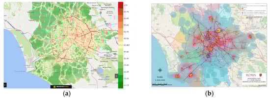
Figure 1.
(a) Map of nitrogen dioxide (NO₂) concentration in the Municipality of Rome. Source: Department of Epidemiology of the Regional Health Service of Lazio. (b) Flood risk areas in Rome. Municipality of Rome, SIMU Department.
A critical concern is the fragmentation of undeveloped land, particularly in areas surrounding the GRA. Continuous urban expansion threatens to eliminate the remaining gaps in Rome’s ecological network, further exposing the city to the impacts of climate change. Key vulnerabilities include the intensification of heat islands (Figure 2a), flooding, soil erosion, and land degradation. To address these pressing issues, it is essential to expand and strengthen Rome’s ecological network (Figure 2b), with a particular emphasis on the role of street trees in bolstering urban resilience.
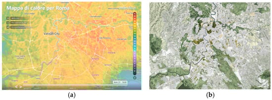
Figure 2.
(a) Real-time mapping of the urban heat island in Rome. It can be seen that the most critical areas (orange-red color) are located in the eastern part of the city, while in the western part, the presence of vegetation has a mitigating effect that lowers the urban temperature. (b) Mapping of green areas in Rome.
Despite these challenges, Rome boasts a remarkable tree heritage [59]. The city’s vast territorial expanse includes large historical parks, peri-urban agricultural zones, and an urban fabric that is surprisingly porous. These features provide a robust green infrastructure with immense ecological potential. Rome’s numerous urban parks and historical villas represent valuable opportunities to extend and integrate its ecological network, offering a path toward a more resilient and sustainable future [60,61,62].
Rome covers a total area of 129,000 hectares, of which 43,000 hectares are designated as green spaces, while approximately 50,000 hectares are agricultural land. These figures underscore Rome’s identity as a true “green capital”. The city’s forest heritage is rich and diverse, encompassing monumental trees—both as solitary specimens and as rows lining streets—as well as forest fragments located within protected areas.
The Metropolitan City of Rome encompasses an extensive range of protected natural areas: three national protected zones (including two State Nature Reserves and one Marine Protected Area), 47 regional protected areas (comprising 10 Natural Parks, 19 Nature Reserves, and 18 Natural Monuments), 56 Special Areas of Conservation (SAC), eight Special Protection Areas (SPA), and four ZPS/ZCS zones. Additionally, remnants of the ancient countryside, such as lowland forests and minor marshes, continue to provide habitats for wildlife, preserving Lazio’s biodiversity. Archeological sites like Appia Antica and Ostia Antica, integrated into the urban fabric, further reinforce the city’s ecological network while enriching its cultural and landscape diversity [63].
By 2016, Rome had cataloged more than 120,000 street trees, an invaluable resource for the city. With targeted interventions, this extensive arboreal heritage holds significant potential to enhance ecosystem services, mitigate environmental impacts, and transform the urban landscape. Alongside other green areas, street trees play a crucial role in the city’s “green system”, bolstering ecological connectivity. Furthermore, compared to other large-scale urban projects, planting new trees is a cost-effective and impactful strategy for revitalizing urban spaces and improving residents’ quality of life.
2.2. Brief History of Street Trees in Rome
Street trees in Rome are a defining feature of the urban landscape, contributing to the city’s unique identity. From the iconic elms and plane trees to lime trees, stone pines, and cypresses, the street trees of Rome reflect various historical periods and urban transformations [64,65,66]. The plane tree, for example, is a legacy of the Savoy monarchy and its role in shaping the newly unified capital; the stone pine, introduced at the end of the 19th century, became a hallmark of urban planning around Rome’s archeological zones; and the holm oaks of Viale Mazzini, designed by Raffaele De Vico, helped define the city’s landscape in the early 20th century.
The census carried out in June 2016 estimated that Rome’s total tree heritage included around 315,000 trees, including 120,000 street trees, 180,000 trees in parks and historic villas, and 15,000 trees on school grounds. This census did not include some of the greenest areas of the city, such as the 10th Municipal District, certain large parks, or areas under the jurisdiction of other municipal authorities (e.g., council housing, senior centers, libraries, and schools). Nevertheless, this is still the most comprehensive available dataset on Rome’s tree heritage, offering a valuable starting point for further analysis. The distribution of street tree species is fairly balanced, with 51% deciduous trees and 48% evergreen trees, while palms and similar species constitute a small fraction (1%). The census recorded 129 different genera, with the most common being Pinus (16%), Quercus (12%), Robinia (9%), Platanus (8%), Ligustrum (6%), and Tilia (5%). More than 100 other genera were present, though in lower frequencies (less than 4%).
2.3. Current Regulatory Context
Street trees are a prescriptive component (“componenti di completamento”) of the Ecological Network (Rete Ecologica) outlined in the General Regulatory Plan of the Municipality of Rome (PRG), approved in 2008. This plan incorporates tree rows across the entire municipal territory from a design perspective.
Additionally, the Quality Charter, developed as part of Rome’s General Regulatory Plan, serves as a key tool for identifying street tree lines protected by the Superintendence of Landscape Heritage. It recognizes tree-lined streets as essential elements of open spaces and prioritizes the preservation of original tree compositions deemed significant to the city’s urban layout and historical identity. The Quality Charter specifically safeguards avenues lined with plane trees from the reign of Umberto I, as well as those featuring pine and holm oak trees. In certain neighborhoods, it also protects rows of trees that reflect the evolving urban contexts of different historical periods.
The primary goal is to preserve the distinctive character of streets and neighborhoods, which contribute to Rome’s diverse landscapes. This identity must be carefully maintained even when planning tree replacements or new plantings, ensuring that the city’s unique urban heritage is preserved for future generations.
It is important to note that Article 18 of the Public Green Regulation [67] specifically addresses the issue of preserving the identity of Roman landscapes [68,69]. Based on an analysis of the historical development of street trees in Rome and the scientific literature on the topic, several key points emerge.
The species selected for street trees in Rome are deeply intertwined with the city’s political and cultural history over the past two centuries. Understanding this historical context is crucial for effective planning and management. Over time, the composition of tree rows has evolved, often driven by cultural trends, architectural considerations, or practical challenges such as pests or stability issues. Street trees are not merely aesthetic or environmental elements; they are integral to a neighborhood’s identity [70,71]. They complement the area’s architectural style and materials, providing continuity and a distinct sense of place that should be preserved whenever possible [72,73].
In recent years, there has been a noticeable trend toward greater species diversity in street tree planting. While this has introduced a wider variety of species, it has also led to the proliferation of urban areas lacking a cohesive identity due to the chaotic mixing of tree types. This trend contrasts with the principle of preserving trees that reflect specific historical periods.
In managing Rome’s street tree heritage, it is essential to strike a balance between conserving the unique character of each neighborhood and addressing the need for resilient, stable, and climate-adapted species. Strategic planning must integrate historical preservation with forward-looking solutions, ensuring that Rome’s urban landscape remains both distinctive and sustainable.
2.4. Methodological Approach
The structure of this study unfolds in several stages. In the previous paragraphs, we introduced the study area—Rome, Italy—focusing on the city’s environmental challenges, including urban heat islands, air pollution, and flooding caused by soil sealing, which require strategic and targeted solutions. At the same time, we highlighted the opportunities offered by Rome’s rich natural heritage. Additionally, we emphasized the historical significance of trees in Rome, recognizing their enduring contribution to the city’s planning and identity.
To build a comprehensive cognitive framework, we then begin with an analysis of the regulatory context and the thematic mapping of Rome’s urban territory; the latter provides a multilayered understanding of the city’s green infrastructure, including its tree-lined streets. A detailed sample survey of streets across all municipal districts assesses the condition of street trees, evaluating canopy health and soil quality. The results are then mapped geographically, offering a visual representation of the findings. Based on these results, a new census of street trees is proposed.
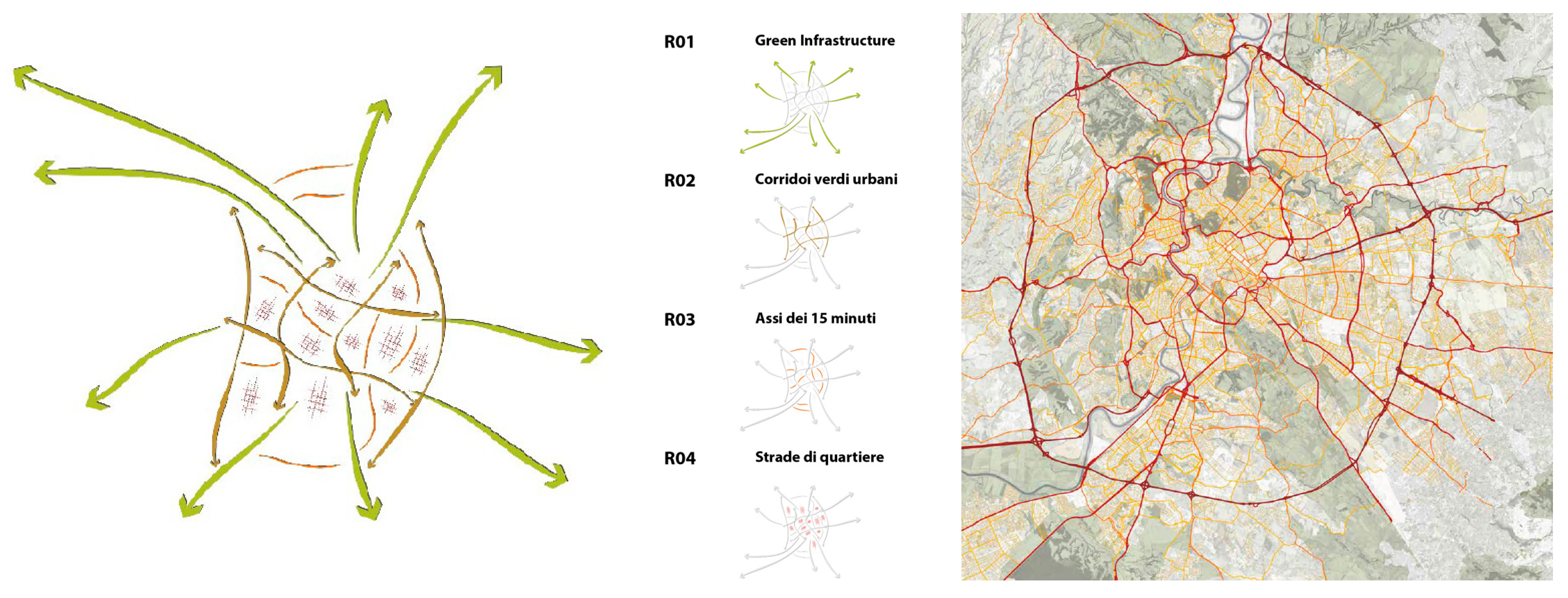
Based on the findings from the sample survey of street trees and an interpretative analysis of their distribution along different road types, an interpretative framework is used for developing Rome’s Street Tree Management Plan (STMP), which links urban-form and street typologies to the specific functions that street trees fulfill in different urban contexts. The structure of this interpretative framework involves two key classifications and reorganizations of the data.
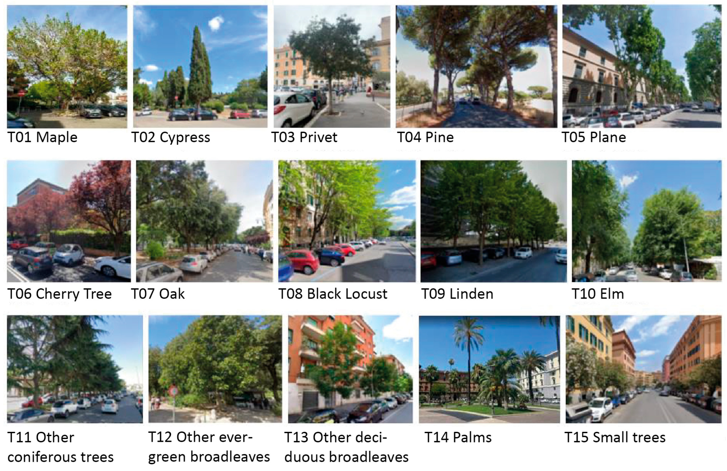
- Classification of Trees by Dendrological Types: this process grouped the numerous recorded species and varieties into dendrological types, consolidating botanically or functionally similar species into broader categories (see Figure 3).
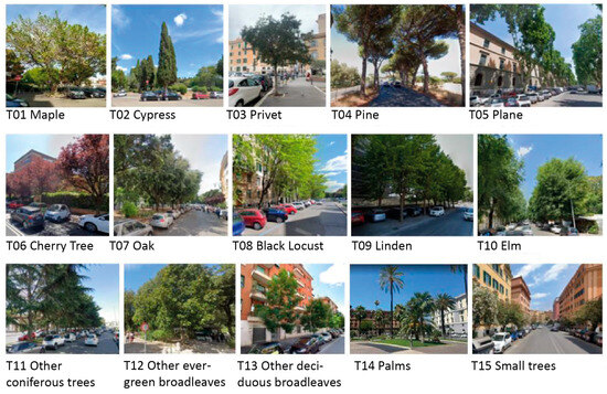 Figure 3. Exemplary images of street trees categorized by dendrological type.
 - Reclassification of Roads by the “Role” of Trees: roads were reorganized based on the landscape functions required of street trees, following a hierarchical scheme with four road types: R01: radial axes (consular roads), which historically serve as primary routes extending from the city center; R02: roads for the fast flow of traffic between neighborhoods, typically arranged in a ring-shaped layout; R03: “15-min urban axes”, which are the main streets within each district, supporting local accessibility and connectivity; and R04: residential neighborhood roads.
This structured approach allows for a nuanced understanding of the relationship between street trees, urban morphology, and street typology, facilitating more targeted and strategic tree interventions throughout Rome.
Finally, the guiding principles for selecting tree species for replacement interventions have been developed, based on the biodiversity distribution of the species and their vegetative response to past and present climatic conditions. Analyses by Esperon-Rodriguez et al. [74] highlight the significant impact of climate change on urban greenery, emphasizing the need for adaptive planning strategies. To ensure the long-term success of urban greening initiatives, it is crucial to align climate projections with the ecological niches of tree species. The assessment of tree species resilience to climate change is grounded in the ecological parameters identified by Esperon-Rodriguez et al. (2022) for the species contributing to Rome’s urban greenery. Additionally, climate scenarios from the WorldClim dataset [75] provide a valuable framework for evaluating future environmental conditions and guiding species selection.
3. Interpretive Framework and Purposed Strategies for Rome STMP
3.1. Street Tree Assessement
The results of the classification of street trees by dendrological types are presented in Table 1 and Figure 3.

Table 1.
Botanical entities and numerical consistency of the street tree species groupings in relation to the total number of trees in Rome (first column) and the total number of street trees (second column) from the 2016 census.
Overall, the predominant component among trees involves pines (16%, over 50,000 plants), followed by oaks and species with minor size (over 12% and 35,000 plants each), while a significant presence is related to locust trees (nearly 10%). These data are not reflective of the same proportions in street trees; here, in fact, the predominant species is the plane tree (12.3 percent, nearly 15,000 plants), followed by pine (11.7 percent) and linden trees (7.6%), if we exclude species with a minor size.
In street trees, compared to city trees considered as a whole, the dendrological types referring to oak (7.1 vs. 12.4%, in the case of Rome relating predominantly to holm oak), locust, elm, and cypress assume a less prominent role, while in the type referring to maple, the role is greater (6.4 vs. 4.2%). A rather marginal role in numerical terms, finally, is played by species pertaining to the types referring to other conifers (0.3%), other evergreen broadleaf trees (1.9%), and palms (0.4%).
The sample survey carried out has revealed that the structure of Rome’s street tree population is significantly imbalanced, with large adult trees making up nearly 50%, medium-sized adult trees around 35%, and younger trees approximately 16% of the population. Considering that the future of the city’s street tree heritage depends on this latter class, the overall structural imbalance becomes evident. In particular, the Italian stone pine, plane tree, and elms show an “imbalanced” structure, with a significant predominance of large adult trees (values ranging between 62% and 75%).
The analysis aimed at assessing the condition of street trees highlighted the need to plant new trees in 15.3% of cases due to missing trees, in addition to 3.7% of cases where tree replacement is necessary. Approximately 81% of trees are in good condition in terms of crown vigor. In general, the number of trees that need to be replaced to restore the continuity of tree rows—considered optimal for maximizing the functions of a street tree planting—is not so high as to justify, in most cases, the renewal of the entire planting. Such renewal is sometimes recommended to maintain a uniform management of the tree formation.
For the existing tree heritage, it is important to ensure efficient growth conditions, particularly in the root zone, also due to reasons linked to climate change. The condition of the space at the base of each tree—where the hard landscape of the roadway or sidewalk is interrupted to accommodate the base of the tree trunk—is satisfactory in only 31% of cases. In 45% of cases, restoration is needed, and in 24% of cases, new space needs to be created, as it is entirely missing, unrecognizable, or otherwise inadequate for the functionality of the rooting area.
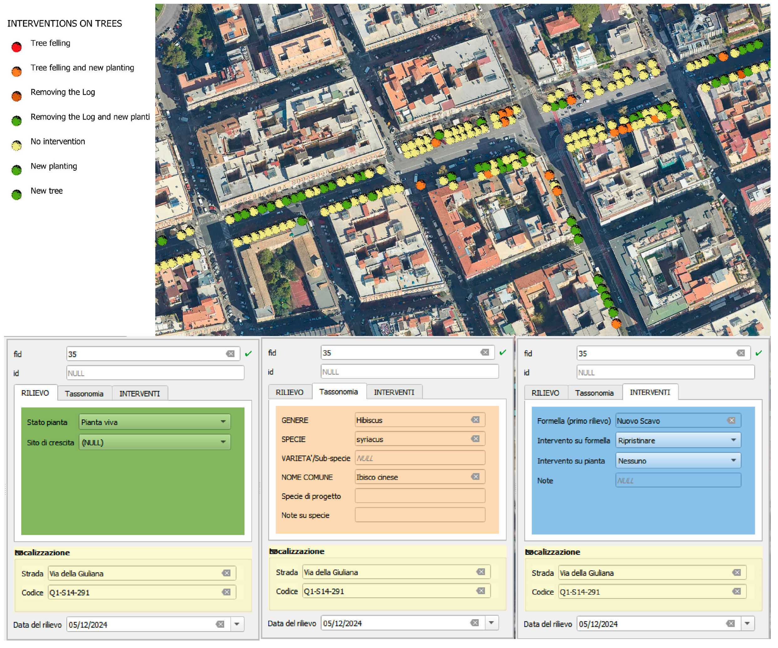
Based on the results of the sample survey, the STMP deems a new, comprehensive census of street trees in Rome is necessary to update and enrich the 2016 census (see Section 2.2 and Table 1). The STMP outlines that each street tree will be assigned a unique code, with data collected using smartphones equipped with the Q-Field application (Figure 4). The data will include information on taxonomy (genus, species, variety), the tree’s condition (e.g., living, dead standing, stump, or vacant spot), and the state of its growth site (e.g., in good condition or requiring restoration). This information will be integrated into the Green Spaces platform, which is being adopted by the Rome Municipality’s Technical Office.
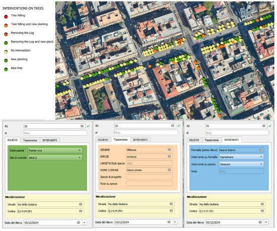
Figure 4.
Orthophoto with geolocalization of street trees and screens with various fields for entering survey data with smartphones.
3.2. Strategies for Street Tree Development
In the context of expanding and enhancing Rome’s tree coverage, including along its road network, the STMP proposes two key design criteria:
- (1)
- Consistency with the history and identity of places, taking into account the relationships with the urban architectural context. It also means that the replacement or integration of trees along existing rows should prioritize planting trees of the same species to maintain continuity, unless there is a clear opportunity for improvement or diversification, as outlined in Articles 18 and 19 of the Green Regulations of Rome [67].
- (2)
- Consistency with the morphological structure of the city: the tree-planting strategy should respect the city’s distinctive radial structure, defined by the main consular roads, the ring roads connecting neighborhoods, and the diverse urban fabrics. These include structuring axes, promenades, and local streets that provide access to residential areas.
According to the adopted interpretative classification of streets based on the role of their trees in the urban landscape (see Section 2.3), strategies are tailored to different road types, categorized by the role of street trees as follows.
R01—“green infrastructure”, which is mainly represented by the radial roads (vie consolari), should be potential ecological connections between the large internal urban green areas and the open territory. Rome’s morphological structure is defined by the radial layout of its consular roads, which extend from the city center to the periphery. These roads pass through various landscapes, urban parks, gardens, and undeveloped green spaces, maintaining a connection between the city and the countryside—not just in terms of roads and railways but also as green infrastructure. These types of roads are characterized by pine and plane trees, which are like landmarks when one comes from the countryside of Rome to the inner-urban area. The proposed strategy for these types of roads is to strengthen the ecological connection and reconfigure them as linear hubs for sustainable mobility.
R02—“ecological corridors”, which are streets characterized by large sections designed to provide fast flow traffic, should assume the potential role of building an ecological urban network on a large scale if accompanied by other interventions on linear beds with grass and shrub vegetation. Furthermore, these roads can play a strategic role in the creation of a linear hub for cycle–pedestrian mobility and the related facilities. The selection of tree species will give priority to specimens of greater bearing with extensive crowns. For continuous flowerbeds, where possible, different species should be integrated to improve biodiversity and strengthen ecological corridors within the urban environment.
R03—“urban axes of the 15-min city” are the main streets within each district, usually characterized by shops at ground-floor level and sidewalks useful for pedestrians. For R03-type roads, smaller tree species with seasonal blooms can also be planted, which can help improve the quality of public space by providing shade on the sidewalk and making rest areas equipped with benches more comfortable. The project of street trees along these streets should consider the whole sidewalk as a public space, improving its quality, together with the other street furnitures.
R04—“neighborhood residential streets” are the streets for the internal circulation in residential areas, with trees having the role of creating shade for parked cars and pedestrian routes to private buildings. In R04-type roads, the biodiversity of smaller-sized species can be enhanced.
3.3. Street Tree Master Plan as a Strategic Vision of the City
To redevelop Rome’s street tree system in harmony with its historical and urban identity, the guiding principle of the STMP is inspired by the “green star” concept [66], with the consular roads serving as the radial rays, reinforced by new green infrastructure that extends outward.
The vision for Rome’s future urban landscape is embodied in the “green star” (Figure 5), where the consular roads (R01) act as the rays, enhanced by the strategic planting of new trees to create green infrastructure. The Tiber River’s final stretch forms the “tail” of this green comet. A secondary network of roads with high urban flow (R02), which traverse various neighborhoods, is envisioned as ecological corridors. These corridors would connect green spaces within the city and intersect with the radial road system, strengthening ecological continuity. To bring the “green star” vision to life, new initiatives were developed to expand tree coverage along Rome’s street network, aligning with the city’s morphological structure. The STMP proposes intervention scenarios to increase the tree population, focusing primarily on the major roads that define the “green star”, including inter-district ring roads. Additionally, the plan emphasizes the conservation and maintenance of existing street trees. This includes replacing missing trees along existing rows and expanding tree pits to enhance tree health, resilience, and adaptability to climate change; a practical example is shown in Figure 6 and Figure 7. These measures aim to ensure a sustainable and vibrant green infrastructure that supports both the environment and the city’s historical identity.

Figure 5.
Concept drawing of the master plan strategy, with the consular roads (radial—R01) as green infrastructures and circular roads (R02) as green corridors connecting different districts.
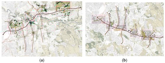
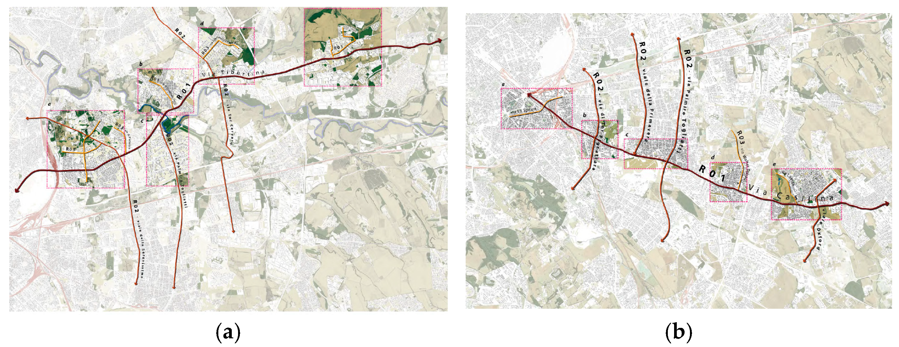
Figure 6.
In-depth study of the STMP along Via Tiburtina (a) and Via Casilina (b) in Rome, which are radial roads (R01) that cross several streets and neighborhoods. To enhance tree coverage and strengthen the green network, interventions on individual streets must be complemented by broader actions in adjacent areas, following the hierarchical street system (R01, R02, R03, R04).
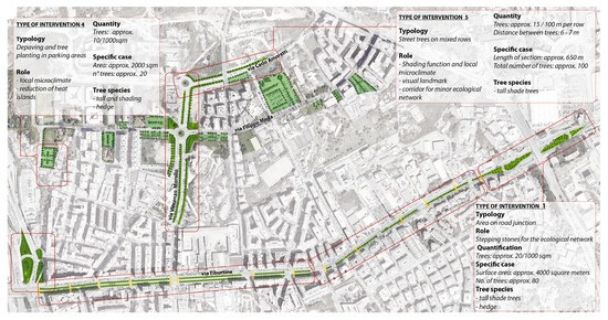
Figure 7.
A more detailed view of Via Tiburtina, a critical area affected by the heat island effect. To mitigate this and improve drainage, road intervention should include depaving and the planting of new trees in parking lots and the remaining green spaces.
The STMP estimate forecasts the planting of 15,000 trees along the main roads of the network, specifically R01 and R02 rank roads. This estimate also considers adjacent areas, such as parking zones and currently unused spaces, that could be repurposed for tree planting.
Interventions on R03 and R04-type roads are expected to be much more widespread and diffuse. In particular, as noted in Section 3.2, tree planting on R03 roads must be integrated with broader improvements to sidewalks and urban furniture, creating significant opportunities for the redevelopment of public spaces.
Figure 8 illustrates an example of an R03 road that, over the years, lost nearly all its street trees due to metro construction works. As part of a broader public space redevelopment plan, new tree planting is scheduled for this road, contributing to the restoration of its urban identity and enhancing its functionality as part of the city’s green infrastructure.

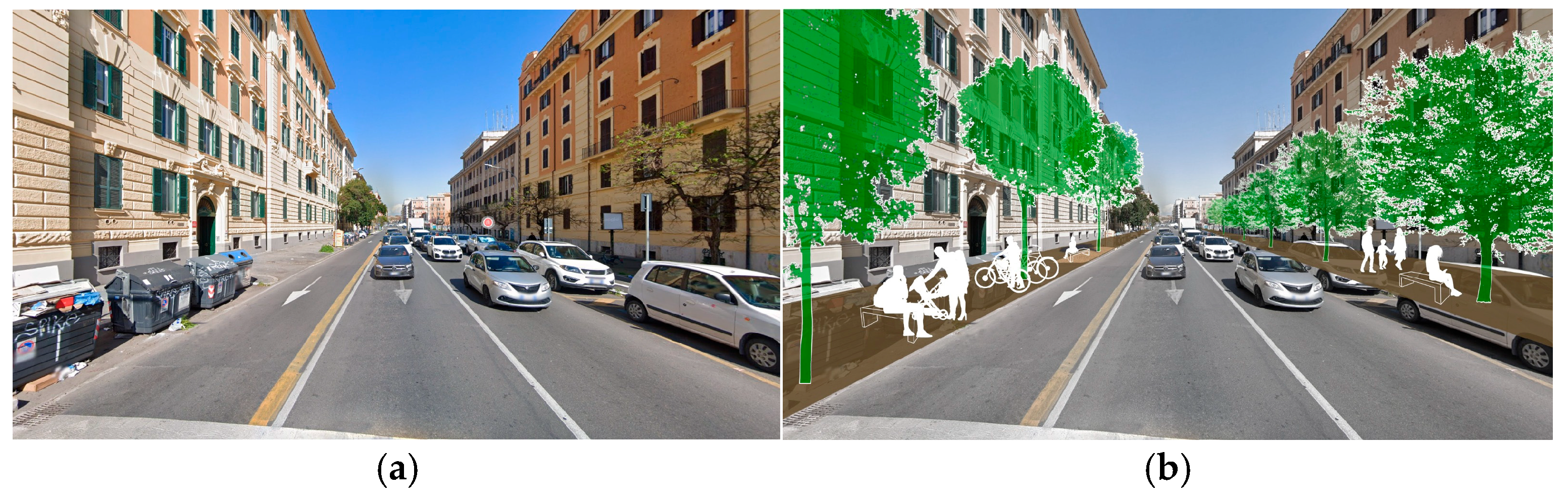
Figure 8.
La Spezia Street in Rome (San Giovanni district, central city). The current situation (a) shows that the street has completely lost its tree-lined avenue. (b) The proposed project envisions the reconstruction of tree rows on both sides of the street, along with the redevelopment of pedestrian sidewalks.
3.4. Guidelines and Criteria for Selecting Tree Species
Within the strategic framework of the STMP, the selection of tree species is of critical importance [76]. Species must be chosen with consideration for their resilience to climate change, ensuring their long-term viability [77,78]. At the same time, landscape considerations tied to the identity of specific places make the use of native species a priority, as they best reflect and preserve Rome’s historical and cultural heritage [79,80,81,82].
However, starting from the premise that no single species is suitable for all situations (due not only to climate change and the unpredictability of events but also to the variety of environmental, microclimatic, and soil conditions found in cities), the selection process must focus, on the one hand, on tree species best suited to the conditions and limitations of the planting sites and, on the other, on maintaining and strengthening an adequate diversity of species. Diversity is, in fact, the key to the success of urban tree-planting programs, as the spread of monocultures can promote the proliferation of pathogens and abiotic stressors. A feasible strategy is to limit any single species to 5–10% of the overall tree population, thereby ensuring that the majority of the population remains intact in the event of, for instance, the spread of a pathogen.
The municipal regulations for public and private greenery stress the importance of prioritizing native species in planting choices [83,84,85]. This approach not only strengthens the identity of the place but also ensures a balanced competition among species, promotes biodiversity and supports a healthy tree and shrub population [86,87]. Due to the difficulty in identifying spontaneous native vegetation in urban areas, the “Roman Forest” in the Botanical Garden of Rome offers valuable guidance for selecting the most appropriate species. This selection should also consider the historical, archeological, architectural, and landscape context. At the same time, existing species such as elms (Ulmus spp.), plane trees (Platanus spp.), and Italian stone pines (Pinus pinea L.) are protected, particularly for their restoration, as they represent important elements of the city’s historical landscape. When restoring tree-lined areas with significant cultural, natural, and landscape value, any replacement trees must be of the same species as those being replaced.
It is important to stress that such species exhibit a “non-equilibrium” structure (see Section 3.1), with a significant prevalence of larger, older trees (values ranging between 62% and 75%). On the one hand, the intent to preserve older and larger trees as much as possible is understandable. However, it must be emphasized that this situation cannot persist indefinitely, as many of these trees have reached the limits of their life cycle (for example, surpassing a century of life in urban conditions, which are known to negatively affect the lifespan of trees). The ability to extend this structure over time depends on maintaining the trees in order for them to have good health and stability.
As for the selection of tree species to be recommended for future plantings based on their resilience to climate change, the analyses using the physiological data from Esperon-Rodriguez et al. (2022) [74] for species contributing to Rome’s urban greenery, along with climate scenarios from the WorldClim dataset, provide valuable insights. The species identified as resilient to Rome’s future climate include Arbutus unedo; Acer negundo; Bauhinia purpurea; Calocedrus decurrens; Catalpa bungei; Cedrus atlantica; Cedrus deodara; Cedrus libani; Celtis australis; Cercis siliquastrum; Ceratonia siliqua; Chamaerops humilis; Cipressus arizonica; Cupressus macrocarpa; Cupressus sempervirens; Eriobotrya japonica; Eucalyptus camaldulensis; Eucalyptus globulus; Ficus carica; Fraxinus angustifolia; Fraxinus ornus; Gleditsia triacanthos; Grevillea robusta; Hibiscus syriacus; Jacaranda mimosifolia; Juniperus chinensis; Koelreuteria paniculata; Lagerstroemia indica; Laurus nobilis; Ligustrum japonicum; Malus floribunda; Melia azedarach; Morus alba; Olea europaea; Phoenix canariensis; Phoenix dactylifera; Pinus halepensis; Pinus pinaster; Pinus pinea; Platanus orientalis; Populus alba; Populus nigra; Punica granatum; Quercus ilex; Quercus suber; Robinia hispida; Salix babylonica; Sequoia sempervirens; Schinus molle; Styphnolobium japonicum; Ulmus americana; Ulmus pumila; Viburnum tinus; Washingtonia filifera; Washingtonia robusta; and Yucca gloriosa. Among these, those native to Italy include the following:
- -
- First-class trees (i.e., trees of significant size): Celtis australis, Cupressus sempervirens, Fraxinus angustifolia, Pinus halepensis, Pinus pinaster, Pinus pinea, Populus alba, Populus nigra, Quercus ilex, Quercus suber.
- -
- Second-class trees (i.e., trees of minor size): Arbutus unedo, Ceratonia siliqua, Cercis siliquastrum, Chamaerops humilis, Ficus carica, Fraxinus ornus, Laurus nobilis, Olea europaea, Viburnum tinus.
4. Discussion
4.1. A Comparative Analysis Between Different STMPs
The findings from successful STMPs worldwide have significant implications for urban planning and public health policies. First, urban planners must prioritize expanding tree canopies in high-density, heat-vulnerable areas to maximize temperature reduction and mitigate extreme heat waves. Several studies show that strategically placing trees along streets and public squares can enhance pedestrian comfort, reducing the risk of heat-related illnesses [88], particularly for vulnerable populations such as the elderly and children.
Second, integrating street trees into urban planning requires balancing species selection with climate resilience. Given climate change projections of higher temperatures and more frequent droughts, it is crucial to select drought-resistant species that can thrive under future conditions. The City of Melbourne’s Urban Forest Strategy (2021) follows this approach by shifting to tree species that require 50% less water while still providing substantial cooling benefits.
Street tree planning also plays a critical role in stormwater management. Trees improve water infiltration and reduce surface runoff, helping cities manage extreme rainfall events and prevent flooding. Studies have shown that urban trees can reduce stormwater runoff by 30–60%, depending on the tree species and soil conditions [89]. For example, Sydney’s urban greening initiatives combine street trees with permeable pavements and rain gardens, enhancing both water retention and air purification.
On a broader scale, STMPs align with public health policies by fostering greener, walkable neighborhoods that encourage physical activity and mental well-being. Urban residents living in tree-lined neighborhoods report lower levels of stress and depression, and green spaces are linked to a reduction in mortality rates. New York City’s Street Tree Master Plan directly ties urban forestry to public health, prioritizing tree planting in low-income neighborhoods with limited green space access.
Rome presents a unique challenge for street tree planning due to its historical and archeological heritage, which imposes additional constraints on tree placement and species selection. Unlike modern urban centers, Rome cannot implement large-scale afforestation projects and must integrate street trees into its existing historical fabric without compromising cultural landmarks. This requires the careful selection of species that not only offer climate resilience but also preserve the city’s aesthetic and historical identity.
Building on the study for the master plan of Rome’s street trees, it would be useful to discuss how a strategic tool like this could be structured.
The primary goal of an urban street tree development and redevelopment program is to manage existing trees, replace hazardous or aging trees, and expand the tree population by planting new ones [90,91]. Key aspects to consider include: (i) climatic and ecological suitability (selecting tree species based on climate projections and ecological niches to ensure long-term resilience); (ii) urban integration (aligning tree planting with urban planning, mobility needs, and public space design); (iii) biodiversity and ecosystem services (promoting species diversity to enhance resilience and maximize benefits such as shade, air quality improvement, and urban cooling); (iv) maintenance and management (establishing guidelines for tree care, pruning, and disease prevention to ensure the sustainability of urban greenery); (v) community involvement (encouraging citizen participation in tree selection, planting, and monitoring efforts).
Considering Rome’s unique historical identity, in which street trees play a significant role, comparing different cities’ approaches highlights both common aspects and the specific characteristics of each context.
While the STMPs of other cities are more of a guiding document for interventions, Rome’s STMP could be considered a planning tool, presenting a comprehensive approach to urban tree management, integrating ecological, environmental, and historical considerations. The plan emphasizes the careful selection of tree species that align with the city’s identity, morphology, and environmental needs. Central to this approach is the principle of selecting the “right tree in the right place”, which takes into account factors such as sidewalk size, street type, existing species, and the potential for climate-resilient or native species [92,93]. The plan also focuses on maintaining the morphological consistency of the city, ensuring that interventions align with Rome’s historical layout, including its radial streets and ring roads, while respecting the distinct urban fabrics of its neighborhoods. This dual emphasis on ecological needs and historical preservation makes Rome’s approach unique compared to other cities.
Paris’s Master Plan for tree planting (2022) shares some similarities with Rome’s STMP, particularly in prioritizing native and climate-resilient species while also considering the historical context. However, Paris places a greater emphasis on creating green networks across streets, parks, and public spaces to enhance ecological connectivity [55]. Additionally, Paris prioritizes species diversity to prevent monocultures, according to the Biodiversity Strategy 2018–2024 [94].
New York’s STMP takes a more utilitarian approach, focusing on the environmental benefits of trees, such as improving air quality, managing stormwater, and reducing the urban heat island effect. Over the past two decades, New York has aggressively expanded its urban tree canopy, planting over a million trees. This plan emphasizes the use of hardy, resilient species such as London plane trees and Norway maples, which can endure the stresses of urban environments, including pollution and extreme weather. While Rome’s plan incorporates environmental concerns, it places greater emphasis on the city’s aesthetic and historical integrity. New York’s approach, by contrast, is more focused on addressing immediate environmental and health challenges through street tree management [53,54]. In other cities, such as Melbourne, Sidney, Vancouver, or London, the STMP is included in a broader context of the Urban Forest Strategy, aiming to increase the canopy cover and address climate adaptation by mitigating heatwaves and droughts. The strategies integrate trees into a broader green infrastructure framework, prioritizing climate-resilient species.
Particularly, London’s Urban Tree Strategy focuses on improving public health, enhancing biodiversity, and increasing resilience to climate change. The city’s ambitious goal of planting two million trees by 2030 reflects a strong commitment to using green infrastructure to address environmental challenges such as air pollution and flooding. London, like New York, has a tree map based on a census of trees, providing an interactive map of canopy cover and tree distribution [95]. When compared to other cities, Rome’s approach reveals both common goals and distinctive differences. While cities like New York, Melbourne, and London place a stronger emphasis on the environmental and public health benefits of urban trees, Rome’s strategy integrates these concerns with a deep respect for the city’s cultural and historical context. The plan’s focus on species selection and the careful integration of trees into the urban environment highlights the importance of context-sensitive urban forestry, where trees contribute not only to ecological resilience but also to the identity and aesthetics of the city.
In Rome, urban trees are not only elements of greenery but also integral to the city’s cultural and historical fabric. Aligning tree species with monumental streets, piazzas, and archeological sites requires a delicate balance between conservation, urban aesthetics, and climate adaptation.
By analyzing strategies from other cities, key similarities emerge, such as the emphasis on biodiversity, climate resilience, and urban cooling. However, Rome’s unique characteristics—such as its extensive archeological heritage, narrow historic streets, and Mediterranean climate—require a tailored approach that integrates green infrastructure with the preservation of its urban history and landscape.
This study compares Rome’s STMP with those of other global cities like Sydney and New York, aiming to identify the best practices and adaptive strategies for balancing urban greening with historical preservation. The insights gained from these comparisons can guide strategies for cities facing similar constraints, ensuring that urban forestry initiatives remain both effective and context-sensitive.
4.2. Limitations and Recommendations for Rome’s STMP
Rome’s STMP serves as a strategic framework to guide the expansion, replacement, and maintenance of street trees within a coherent intervention plan and a vision of the city’s future. Many opportunities for future enhancements can be recognized.
(i) Integration of the STMP with other urban forestry programs. The first issue concerns the integration of the STMP with other ongoing urban forestry programs. These programs aim to significantly expand tree planting, moving from tens of thousands of new street trees to potentially hundreds of thousands (even one million trees), by utilizing larger urban areas for small urban forests. Currently, several urban forestry initiatives are underway in Rome, including the PNRR Urban Forestry Program and the Forest for Rome (F4R) Program, which focus on creating small urban forests in underutilized areas. However, at present, Rome does not offer a publicly accessible interactive map detailing ongoing urban forestry interventions. Such a tool would be invaluable for planning and public engagement.
(ii) Implementation of a strategic plan at the sidewalk scale. The classificatory hypotheses of streets and tree species, from which general intervention strategies are derived, must be understood flexibly. These classifications offer initial guidance but are not directly applicable when making specific decisions about individual street redevelopment projects. Such decisions require detailed, case-by-case landscape assessments. Moving from the urban-scale perspective of the master plan to the landscape-scale perspective of the urban sidewalk involves considering several factors. Trees play an essential perceptual role in the urban scene, interacting with street sections, pedestrian pathways, and the façades of urban buildings. Moreover, the STMP can play an important role in urban contexts, not only for the implementation and conservation of tree heritage but also as a means to enhance citizens’ quality of life [96,97,98]. At this scale, the involvement of landscape architects becomes essential to harmonize these factors into a coherent configuration of public space.
(iii) Database and Data Collection Enhancement. A third issue involves expanding the database and survey data to include additional information, such as the dimensional data of trees, evaluation of ecosystem services provided by individual trees or rows, tree stability assessments (e.g., Visual Tree Assessment), phytosanitary evaluations, and detailed descriptions of the condition of sidewalks and growth sites.
(iv) Building a Participatory Process. A critical issue is the development of a genuine participatory process that involves various institutions, research entities, and—most importantly—citizens in the planning of interventions. The Street Tree Master Plan must evolve into a Street Tree Map, akin to the New York model, as a publicly accessible, interactive tool for citizens.
Simultaneously, in the back office, the Department of Environmental Protection must maintain an extensive database, enriched with diverse fields and data. This database should be managed by the Garden Office’s technicians to ensure meticulous tree asset management and constant tree-by-tree monitoring.
5. Conclusions
The STMP can be considered, according to the approach proposed in this Rome case study, as a sort of strategic plan with general and specific objectives to be achieved within a coherent framework of interventions and according to a future vision of the city. The “grounding” of the plan then takes place at the human scale of the sidewalk, where perceptual assessments must be made, along with the selection of “the right tree in the right place” and the design of public space.
The drafting of the STMP, particularly when evaluating the expansion of tree heritage and the replacement of specimens along an avenue, should take into account several factors:
- The relationship between the network of street trees and the wooded areas within the city, parks, and other urban green spaces, in terms of green infrastructure.
- Consistency with overarching urban and landscape planning.
- Alignment with sector-specific plans related to mobility and sidewalk design, including the introduction of bike lanes and urban furniture.
- Consistency with the morphological structure of the city, considering the typology of streets and the landscape functions of trees (such as trees forming a green infrastructure along vehicle traffic roads or those arranged along pedestrian pathways).
- Consistency with the history and identity of places, taking into account historical factors as well as perceptual relationships with the urban architectural context (alignments, facade screening, perspective backdrops, etc.).
- The distribution of different species along the streets of various neighborhoods, providing support for species selection, which must balance two contrasting needs: on the one hand, promoting biodiversity, and on the other, preserving the historical and perceptual identity of streets characterized by dominant species.
- The selection of species, which must consider two sometimes conflicting factors: the use of native species, which have a distinct landscape identity, and the use of non-native species, which are more resistant to climate change.
- At a detailed scale, the plan translates into a landscape project, addressing contingent factors related to the design of public sidewalk spaces, where physical and spatial constraints often limit the ability of different tree species to develop in suitable growth sites.
In this type of drop-down menu, the key aspects of STMP development have been highlighted based on the case study of Rome. The final question is thus to what extent are history and spatial constraints a part of all STMPs, or are they specific to Rome?
The answer to this question is that each of these aspects should be considered in the drafting of an STMP, activating open processes that involve specialists from various disciplines, including urban planning, forest planning, and landscape design, as well as architectural, botanical, and ecological–environmental aspects.
Of course, there is no universal rulebook, and the most relevant factors in selecting the right tree for the right place may vary from city to city, leading to different approaches and choices tailored to specific situations.
In conclusion, it may be beneficial to establish a network of relationships among cities focused on street tree management to share experiences and research. The ultimate goal would be to find synergies to combat the impacts of climate change on urban environments while preserving each city’s historical and cultural heritage.
Author Contributions
P.C.: Conceptualization, writing and supervision; M.C.: Conceptualization, writing—original draft preparation, review and editing; G.P.: resources, data curation; M.D.: Visualization. All authors have read and agreed to the published version of the manuscript.
Funding
This study on the Street Tree Master Plan was funded by the Municipality of Rome, Italy.
Data Availability Statement
Data were derived from: https://www.comune.roma.it/web-resources/cms/documents/STAMPA_Analisi_e_strategie_per_la_riqualificazione_delle_alberature_stradali_di_Roma_Capitale_20240617.pdf (accessed on 10 January 2025).
Acknowledgments
The Street Tree Master Plan was developed as part of a study conducted by CREA (Research Centre for Forestry and Wood) in collaboration with the Municipality of Rome, Environmental Department, and published by CREA in the book Analisi e Strategie per la Riqualificazione delle Alberature Stradali di Roma Capitale (2024), authored by Piermaria Corona, Matteo Clemente, Alessandro Alivernini, Marco Degaetano, Valerio Di Stefano, Carlotta Ferrara, Walter Mattioli, Francesco Menta, Emanuele Presutti Saba, Giorgio Pontuale, Tiziano Sorgi, and Giuseppe Pignatti. Special thanks for the activities carried out are also extended to Lorenzo Crecco, Benedetta Cucca, Giorgia Di Domenico, Federico Franchi, Davide Mancini, Tommaso Mazzetto, Valerio Moretti, and Elisa Pontuale.
Conflicts of Interest
The authors declare no conflicts of interest.
References
- Blasi, C. Alberate Stradali e Infrastrutture Verdi. Italia Nostra. 2019. Available online: https://www.italianostraroma.org (accessed on 10 January 2025).
- Clemente, M. Rethinking “Streetline Forestscapes” in a Broader Context of Urban Forestry: In between Ecological Services and Landscape Design, with Some Evidence from Rome, Italy. Sustainability 2023, 15, 3435. [Google Scholar] [CrossRef]
- Barbati, A.; Corona, P.; Salvati, L.; Gasparella, L. Natural forest expansion into suburban countryside: Gained ground for a green infrastructure? Urban For. Urban Green. 2013, 12, 36–43. [Google Scholar] [CrossRef]
- Konijnendijk, C.C.; Nilsson, K.; Randrup, T.B.; Schipperijn, J. Urban Forests and Trees; Springer: Berlin/Heidelberg, Germany, 2005. [Google Scholar]
- FAO. Guidelines on Urban and Peri-Urban Forestry; Salbitano, F., Borelli, S., Conigliaro, M., Chen, Y., Eds.; FAO Forestry: Rome, Italy, 2016. [Google Scholar]
- Corona, P.; Alivernini, A. Forests for the world. Ann. Silvic. Res. 2024, 49, 80–81. [Google Scholar] [CrossRef]
- Arnaiz-Schmitz, C.; Schmitz, M.F.; Herrero-Jáuregui, C.; Gutiérrez-Angonese, J.; Pineda, F.D.; Montes, C. Identifying socio-ecological networks in rural-urban gradients: Diagnosis of a changing cultural landscape. Sci. Total Environ. 2018, 612, 625–635. [Google Scholar] [CrossRef]
- Nowak, D.J.; Greenfield, E.J. The increase of impervious cover and decrease of tree cover within urban areas globally (2012–2017). Urban Urban Green 2020, 49, 126638. [Google Scholar] [CrossRef]
- European Commission. Commission Staff Working Document, Technical information on Green Infrastructure (GI), SWD (2013) 155 Final. 2013. Available online: https://ec.europa.eu/environment/nature/ecosystems/docs/green_infrastructures/1_EN_autre_document_travail_service_part1_v2.pdf (accessed on 10 January 2025).
- Goudie, A.S. The Human Impact on the Natural Environment: Past, Present, and Future; Wiley: New York, NY, USA, 2013. [Google Scholar]
- Grimm, N.B.; Faeth, S.H.; Golubiewski, N.E.; Redman, C.L.; Wu, J.; Bai, X.; Briggs, J.M. Global change and the ecology of cities. Science 2008, 319, 756–760. [Google Scholar] [CrossRef]
- World Health Organization. Urban Green Spaces and Health. A Review of Evidence; WHO Regional Office for Europe: Copenhagen, Denmark, 2016. [Google Scholar]
- Konijnendijk, C.C. Evidence-based guidelines for greener, healthier, more resilient neighbourhoods: Introducing the 3–30–300 rule. J. For. Res. 2022, 34, 821–830. [Google Scholar] [CrossRef] [PubMed]
- Scarascia-Mugnozza, G.E.; Guallart, V.; Salbitano, F.; Aalmo, G.O.; Boeri, S. (Eds.) Transforming BioCities: Designing Urban Spaces Inspired by Nature; Springer Nature: Cham, Switzerland, 2023; Volume 20. [Google Scholar]
- Mersal, A. Sustainable urban futures: Environmental planning for sustainable urban development. Procedia Environ. Sci. 2016, 34, 49–61. [Google Scholar] [CrossRef]
- MIPAFF. Strategia Forestale Nazionale. 2022. Available online: https://www.reterurale.it/foreste/StrategiaForestaleNazionale (accessed on 10 January 2025).
- City of Paris. Plan Biodiversit’e de Paris 2018–2024. (Biodiversity Plan of Paris 2018–2024). 2018. Available online: https://cdn.paris.fr/paris/2021/02/17/fbb551749cd3dabdf2b730d5f4097629.pdf (accessed on 10 January 2025).
- Gulsrud, N.M.; Hertzog, K.; Shears, I. Innovative urban forestry governance in Melbourne?: Investigating “green placemaking” as a nature-based solution. Environ. Res. 2018, 161, 158–167. [Google Scholar] [CrossRef]
- Bowler, D.E.; Buyung-Ali, L.; Knight, T.M.; Pullin, A.S. Urban greening to cool towns and cities: A systematic review of the empirical evidence. Landsc. Urban Plann. 2010, 97, 147–155. [Google Scholar] [CrossRef]
- Escobedo, F.J.; Kroeger, T.; Wagner, J.E. Urban forests and pollution mitigation: Analyzing ecosystem services and disservices. Environ. Pollut. 2011, 159, 2078–2087. [Google Scholar] [CrossRef] [PubMed]
- Zairuddin, N.S.; Othman, N.; Malek, N.A. Sustainable Urban Streetscape: Managing trees as green infrastructure. Asian J. Behav. Stud. 2020, 5, 45–57. [Google Scholar] [CrossRef]
- Childers, D.L.; Pickett, S.T.A.; Grove, J.M.; Ogden, L.; Whitmer, A. Advancing urban sustainability theory and action: Challenges and opportunities. Landsc. Urban Plann. 2013, 125, 298–303. [Google Scholar] [CrossRef]
- Niemelä, J. Ecology of urban green spaces: The way forward in answering major research questions. Landsc. Urban Plann. 2014, 125, 298–303. [Google Scholar] [CrossRef]
- Weissert, L.F.; Salmond, J.A.; Schwendenmann, L. A review of the current progress in quantifying the potential of urban forests to mitigate urban CO2 emissions. Urban Clim. 2014, 8, 100–125. [Google Scholar] [CrossRef]
- Metta, A.; Olivetti, M.L. Cities Facing the Wild. In Urban Services to Ecosystems. Future City; Catalano, C., Andreucci, M.B., Guarino, R., Bretzel, F., Leone, M., Pasta, S., Eds.; Springer: Cham, Switzerland, 2021; Volume 17. [Google Scholar] [CrossRef]
- Colding, J. The role of ecosystem services in contemporary urban planning. In Urban Ecology–Patterns, Processes, and Applications; Niemelä, J., Breuste, J., Elmqvist, T., Guntenspergen, G., James, P.P., McIntyre, N., Eds.; Oxford University Press: Oxford, UK, 2011; pp. 228–237. [Google Scholar]
- Galle, N.J.; Halpern, D.; Nitoslawski, S.; Duarte, F.; Ratti, C.; Pilla, F. Mapping the diversity of street tree inventories across eight cities internationally using open data. Urban For. Urban Green. 2021, 61, 127099. [Google Scholar] [CrossRef]
- Ignatieva, M.; Stewart, G.H.; Meurk, C. Planning and design of ecological networks in urban areas. Landsc. Ecol. Eng. 2011, 7, 17–25. [Google Scholar] [CrossRef]
- Egerer, M.; Schmack, J.M.; Vega, K.; Barona, C.O.; Raum, S. The challenges of urban street trees and how to overcome them. Front. Sustain. Cities 2024, 6, 1394056. [Google Scholar] [CrossRef]
- McPherson, E.G. Benefit-based tree valuation. Arboric. Urban For. 2007, 33, 1–11. [Google Scholar] [CrossRef]
- Walmsley, A. Greenways: Multiplying and diversifying in the 21st century. Landsc. Urban Plan. 2006, 76, 252–290. [Google Scholar] [CrossRef]
- Nesbitt, L.; Meitner, M.J.; Sheppard, S.R.J.; Girling, C. The dimensions of urban green equity: A framework for analysis. Urban For. Urban Green. 2018, 34, 240–248. [Google Scholar] [CrossRef]
- Caneva, G.; Bartoli, F.; Zappitelli, I.; Savo, V. Street trees in italian cities: Story, biodiversity and integration within the urban environment. Rend. Lincei. Sci. Fis. Naturali. 2020, 31, 411–417. [Google Scholar] [CrossRef]
- Carmona, M. Contemporary public space, part two: Classification. J. Urban Des. 2010, 15, 157–173. [Google Scholar] [CrossRef]
- MacHarg, I. Design with Nature, 25th ed.; John Wiley & Sons Inc.: Hoboken, NJ, USA; New York, NY, USA, 1995. [Google Scholar]
- Evans, G. Accessibility, urban design and the whole journey environment. Built Environ. 2009, 35, 366–385. [Google Scholar] [CrossRef]
- Ewing, R.; Clemente, O. Measuring Urban Design: Metrics for Livable Places; Island Press: Washington, DC, USA, 2013. [Google Scholar]
- Kaplan, S. The restorative benefits of nature: Toward an integrative framework. J. Environ. Psychol. 1995, 15, 169–182. [Google Scholar] [CrossRef]
- Laurian, L. Planning for street trees and human–nature relations: Lessons from 600 years of street tree planting in Paris. J. Plan. Hist. 2019, 18, 282–310. [Google Scholar] [CrossRef]
- Lachowycz, K.; Jones, A.P. Towards a better understanding of the relationship between green space and health: Development of a theoretical framework. Landsc. Urban Plann. 2013, 118, 62–69. [Google Scholar] [CrossRef]
- Panagopoulos, T.; González Duque, J.A.; Bostenaru, D.M. Urban planning with respect to environmental quality and human wellbeing. Environ. Pollut. 2016, 208, 137–144. [Google Scholar] [CrossRef]
- Westphal, L.M. Social aspects of urban forestry: Urban greening and social benefits: A study of empowerment outcomes. J. Arboric. 2003, 29, 137–147. [Google Scholar]
- Clemente, M. Re-Design dello Spazio Pubblico; FrancoAngeli: Milano, Italy, 2017. [Google Scholar]
- Fonseca, F.; Ribeiro, P.J.G.; Conticelli, E.; Jabbari, M.; Papageorgiou, G.; Tondelli, S.; Ramos, R.A.R. Built environment attributes and their influence on walkability. Int. J. Sustain. Transp. 2021, 16, 660–679. [Google Scholar] [CrossRef]
- Caravaggi, L.; Imbroglini, C.; Lei, A. Rome’s GRAB—Great Bicycle Ring Route—As Complex Landscape Infrastructure. Sustainability 2022, 14, 1023. [Google Scholar] [CrossRef]
- Ortega, E.; Martín, B.; López-lambas, M.E.; Soria-lara, J.A. Evaluating the impact of urban design scenarios on walking accessibility: The case of the Madrid ‘Centro’ district. Sustain. Cities Soc. 2021, 74, 103156. [Google Scholar] [CrossRef]
- Kong, F.; Yin, H.; Nakagoshi, N.; Zong, Y. Urban green space network development for biodiversity conservation: Identification based on graph theory and gravity modeling. Landsc. Urban Plan. 2010, 95, 16–27. [Google Scholar] [CrossRef]
- Blasi, C.; Zavattero, L.; Marignani, M.; Smiraglia, D.; Copiz, R.; Rosati, L.; Del Vico, E. The concept of land ecological network and its design using a land unit approach. Plant Biosyst. 2008, 142, 540–549. [Google Scholar] [CrossRef]
- Bryant, M.M. Urban landscape conservation and the role of ecological greenways at local and metropolitan scales. Landsc. Urban Plan. 2006, 76, 23–244. [Google Scholar] [CrossRef]
- Trees and Design Action Group. Trees in Hard Landscapes: A Guide for Delivery. 2014. Available online: https://www.tdag.org.uk/ (accessed on 15 December 2024).
- City of Vancouver, 2020. Street Trees. Available online: https://opendata.vancouver.ca/explore/dataset/public-trees/map/?disjunctive.neighbourhood_name&disjunctive.on_street&disjunctive.species_name&disjunctive.common_name&location=11,49.2565,-123.12999 (accessed on 2 February 2025).
- City of Sydney, Street Tree Master Plan, 2023. Available online: https://www.cityofsydney.nsw.gov.au/strategies-action-plans/street-tree-master-plan (accessed on 2 February 2025).
- New York City, Street Tree Map. Available online: https://tree-map.nycgovparks.org/ (accessed on 22 April 2024).
- Elliott, R.M.; Shetty, N.H.; Culligan, P.J. From a Census of 680,000 Street Trees to Smart Stormwater Management: A Study of Efficacy and Economics of Street Tree Guards in New York City; Civil Engineering and Engineering Mechanics, Columbia University: New York, NY, USA, 2018. [Google Scholar]
- Vauléon, Y. A Master Plan for Planting Trees in Paris. 2022. Available online: https://wien.arbeiterkammer.at/interessenvertretung/meinestadt/veranstaltungen/YVauleon_16.5.2022.pdf (accessed on 10 January 2025).
- Chakraborty, T.; Lee, X. Global UHI Data Table. Mendeley Data, V1. 2018. Available online: https://data.mendeley.com/datasets/h9pfd42fv9/1 (accessed on 2 February 2025).
- Ziter, C.D.; Pedersen, E.J.; Kucharik, C.J.; Turner, M.G. Scale-dependent interactions between tree canopy cover and impervious surfaces reduce daytime urban heat during summer. Proc. Natl. Acad. Sci. USA 2019, 116, 7575–7580. [Google Scholar] [CrossRef]
- Nowak, D.J.; Hirabayashi, S.; Bodine, A.; Greenfield, E. Tree and forest effects on air quality and human health in the United States. Environ. Pollut. 2014, 193, 119–129. [Google Scholar] [CrossRef]
- Stiles, R.; Bouche-Pillon, S.; Brinkhuijsen, M.; de Vries, J.; Di Carlo, F.; Fetzer, E.; Libbrecht, H.; Maksymiuk, G.; Meeres, S.; Meireles Rodrigues, F. (Eds.) Rome’s Landscape; Le:Notre Landscape Forum: Tartu, Estonia, 2013. [Google Scholar]
- Frondoni, R.; Mollo, B.; Capotorti, G. A landscape analysis of land cover change in the municipality of Rome (Italy): Spatio-temporal characteristics and ecological implications of land cover transitions from 1954 to 2001. Landsc. Urban Plan. 2011, 100, 117–128. [Google Scholar] [CrossRef]
- Quatrini, V.; Tomao, A.; Corona, P.; Ferrari, B.; Masini, E.; Agrimi, M. Is new always better than old? Accessibility and usability of the urban green areas of the municipality of Rome. Urban For. Urban Green. 2019, 37, 126–134. [Google Scholar] [CrossRef]
- Ferrari, B.; Quatrini, V.; Barbati, A.; Corona, P.; Masini, E.; Russo, D. Conservation and enhancement of the green infrastructure as a nature-based solution for Rome’s sustainable development. Urban Ecosyst. 2019, 22, 865–878. [Google Scholar] [CrossRef]
- Tomao, A.; Secondi, L.; Carrus, G.; Corona, P.; Portoghesi, L.; Agrimi, M. Restorative urban forests: Exploring the relationships between forest stand structure, perceived restorativeness and benefits gained by visitors to coastal Pinus pinea forests. Ecol. Indic. 2018, 90, 594–605. [Google Scholar] [CrossRef]
- Attorre, F.; Bruno, M.; Francesconi, F.; Valenti, R.; Bruno, F. Landscape changes of Rome through tree-lined roads. Landsc. Urban Plan. 2000, 49, 115–128. [Google Scholar] [CrossRef]
- Ricotta, C.; Grapow, L.C.; Avena, G.; Blasi, C. Topological analysis of the spatial distribution of plant species richness across the city of Rome (Italy) with the echelon approach. Landsc. Urban Plan. 2001, 57, 69–76. [Google Scholar] [CrossRef]
- Corona, P.; Clemente, M.; Alivernini, A.; Degaetano, M.; Di Stefano, V.; Ferrara, C.; Mattioli, W.; Mmenta, F.; Presutti Saba, E.; Pontuale, G.; et al. Analisi e Strategie per la Riqualificazione delle Alberature Stradali di Roma Capitale, Comune di Roma, Consiglio per la Ricerca in Agricoltura e L’analisi Dell’economia Agraria. Roma. 2024. Available online: https://www.crea.gov.it/en/web/foreste-e-legno/-/foreste-urbane-riqualificazione-delle-alberature-stradali-di-roma-capitale (accessed on 2 February 2025).
- Comune di Roma, 2021. Regolamento Capitolino del Verde Pubblico e Privato e del Paesaggio Urbano di Roma Capitale. Approvato con Deliberazione dell’Assemblea Capitolina n. 17 del 12 marzo 2021. Available online: https://www.comune.roma.it/web-resources/cms/documents/DAC_n._17_2021_Regol_Verde.pdf (accessed on 17 January 2025).
- Frohmann, E. Trees in the city—Perception and aesthetic expression. In Plants in Urban Areas and Landscape: Pual; Slovak University of Agriculture in Nitra: Nitra, Slovakia, 2020; pp. 3–9. [Google Scholar]
- Parsons, R.; Terry, D. Good looking: In defense of scenic landscape aesthetics. Landsc. Urban Plan. 2002, 60, 43–56. [Google Scholar] [CrossRef]
- Devi, A.; Bala, N.; Saikia, J. Residents’ perceptions and attitudes towards street trees in urban residential areas of Guwahati City, Assam. Int. J. Environ. Sci. Nat. Res. 2023, 29, 1–10. [Google Scholar] [CrossRef]
- Byrne, J.A.; Lo, A.Y.; Jianjun, Y. Residents’ understanding of the role of green infrastructure or climate change adaptation in Hangzhou, China. Landsc. Urban Plan. 2015, 138, 132–143. [Google Scholar] [CrossRef]
- Clemente, M. Street Tree Redevelopment in Rome’s Historical Landscapes: From Strategic Vision to Streetscape Design. Land 2025, 14, 233. [Google Scholar] [CrossRef]
- Corner, J. Recovering Landscape: Essays in Contemporary Landscape Architecture, 1st ed.; Princeton Architectural Press: New York, NY, USA, 1999. [Google Scholar]
- Esperon-Rodriguez, M.; Tjoelker, M.G.; Lenoir, J.; Baumgartner, J.B.; Beaumont, L.J.; Nipperess, D.A.; Power, S.A.; Richard, B.; Rymer, P.D.; Gallagher, R.V. Climate change increases global risk to urban forests. Nat. Clim. Chang. 2022, 12, 951–955. [Google Scholar] [CrossRef]
- Fick, S.E.; Hijmans, R.J. WorldClim 2: New 1-km spatial resolution climate surfaces for global land areas. Int. J. Climatol. 2017, 37, 4302–4315. [Google Scholar] [CrossRef]
- D’Amato, L.; Bartoli, F.; Savo, V.; Paiella, P.A.; Messina, F.; Caneva, G. Distribution Pattern of Urban Street Trees in Rome (Italy): A Multifactorial Evaluation of Selection Criteria. Sustainability 2023, 15, 14065. [Google Scholar] [CrossRef]
- McPhearson, T.; Pickett, S.T.A.; Grimm, N.B.; Niemela, J.; Alberti, M.; Elmqvist, T.; Weber, C.; Haase, D.; Breuste, J.; Qureshi, S. Advancing urban ecology toward a science of cities. BioScience 2016, 66, 198–212. [Google Scholar] [CrossRef]
- Peng, J.; Tian, L.; Liu, Y.; Zhao, M.; Wu, J. Ecosystem services response to urbanization in metropolitan areas: Thresholds identification. Sci. Total Environ. 2017, 607, 706–714. [Google Scholar] [CrossRef] [PubMed]
- Bourassa, S.C. A paradigm for landscape aesthetics. Environ. Behav. 1990, 22, 787–812. [Google Scholar] [CrossRef]
- Gobster, P.H.; Nassauer, J.I.; Daniel, T.C.; Fry, G. The shared landscape: What does aesthetics have to do with ecology? Landsc. Ecol. 2007, 2, 959–972. [Google Scholar] [CrossRef]
- Ruper, R. Landscape and Urban Planning Evaluations of landscape preference, complexity, and coherence for designed digital landscape models. Landsc. Urban Plan. 2017, 157, 407–421. [Google Scholar]
- Bianchini, L.; Egidi, G.; Alhuseen, A.; Sateriano, A.; Cividino, S.; Clemente, M.; Imbrenda, V. Toward a Dualistic Growth? Pop-609 ulation Increase and Land-Use Change in Rome, Italy. Land 2021, 10, 749. [Google Scholar] [CrossRef]
- Ferrini, F. Greening the city. La scelta delle specie. Ri-Vista. Res. Landsc. Archit. 2017, 15, 60–71. [Google Scholar] [CrossRef]
- Regione Lazio, 2022. Linee Guida alla Scelta di Specie Arboree e Arbustive da Utilizzare Negli Interventi di Forestazione Urbana e Periurbana nel Territorio della Regione Lazio Approvate con Determinazione n. G14103 del 17 Novembre 2021. Available online: https://progetti.regione.lazio.it/ossigeno/wp-content/uploads/sites/62/DD-Linee-Guida-scelta-di-specie-arboree-e-arbustive.pdf (accessed on 10 January 2025).
- Roman, L.A.; Scyphers, S.B.; Rogan, J. Drivers of tree distribution in an urban ecosystem. Landsc. Urban Plan. 2015, 136, 87–95. [Google Scholar] [CrossRef]
- Referowska-Chodak, E. Urban tree biodiversity: A strategy for sustainable development. Sustain. For. 2019, 11, 916. [Google Scholar] [CrossRef]
- Sjöman, H.; Watkins, H.; Kelly, L.J.; Hirons, A.; Kainulainen, K.; Martin, K.W.; Antonelli, A. Resilient trees for urban environments: The importance of intraspecific variation. Plants People Planet 2024, 6, 1180–1189. [Google Scholar] [CrossRef]
- Salmond, J.A.; Tadaki, M.; Vardoulakis, S.; Arbuthnott, K.; Coutts, A.; Demuzere, M.; Dirks, K.N.; Heaviside, C.; Lim, S.; Macintyre, H.; et al. Health and climate related ecosystem services provided by street trees in the urban environment. Environ. Health 2016, 15 (Suppl. S1), 36. [Google Scholar] [CrossRef] [PubMed]
- Xiao, Q.; McPherson, E.G. Surface water storage capacity of twenty tree species in Davis, California. J. Environ. Qual. 2016, 45, 188–198. [Google Scholar] [CrossRef] [PubMed]
- Mullaney, J.; Lucke, T.; Trueman, S.J. A review of benefits and challenges in growing street trees in paved urban environments. Landsc. Urban Plan. 2015, 134, 157–166. [Google Scholar] [CrossRef]
- Fernandes, C.; Martinho da Silvaa, I.; Patoilo Teixeiraa, C.; Costa, L. Between tree lovers and tree haters. Drivers of public perception regarding street trees and its implications on the urban green infrastructure planning. Urban For. Urban Green. 2019, 37, 97–108. [Google Scholar] [CrossRef]
- Blasi, C.; Biondi, E. La Flora in Italia. Ministero dell’Ambiente e della Tutela del Territorio e del Mare; Sapienza Università Editrice: Roma, Italy, 2017. [Google Scholar]
- Del Vico, E.; Capotorti, G.; Lattanzi, E.; Tilia, A.; Blasi, C. La flora urbana. In Strategia Nazionale del Verde Urbano; Atelli, M., Blasi, C., Boldini, G., Cignini, B., Cosenza, G., Emiliani, V., Marchetti, M., Maggiore, A.M., Pericoli, T., Ricciardi, A., et al., Eds.; MATTM: Roma, Italy, 2018. [Google Scholar]
- Ville de Paris, Plan_biodiversité_de_Paris_2018–2024. Available online: https://www.paris.fr/pages/un-nouveau-plan-biodiversite-pour-paris-5594 (accessed on 10 January 2025).
- London Tree Map. Available online: https://www.london.gov.uk/programmes-and-strategies/environment-and-climate-change/parks-green-spaces-and-biodiversity/trees-and-woodlands/london-tree-map?ac-37687=37686 (accessed on 10 January 2025).
- Madden, K. How to Turn a Place Around: A Placemaking Handbook; Project for Public Space: New York, NY, USA, 2018. [Google Scholar]
- Santos, T.; Silva, C.; Tenedório, J.A. Promoting citizens’ quality of life through Green Urban Planning. In Geographical Information Systems Theory, Applications and Management, Communications in Computer and Information Science; Ragia, L., Laurini, R., Rocha, J.G., Eds.; Springer International Publishing: Berlin/Heidelberg, Germany, 2019; pp. 153–175. [Google Scholar]
- Zairuddin, N.S.; Othman, N.; Abdul Malek, N. A Review on Tree Sensitive Urban Design (TSUD) Approach as potentials Streetscape Design Guidelines. Environ.-Behav. Proc. J. 2020, 5, 215–221. [Google Scholar] [CrossRef]


Disclaimer/Publisher’s Note: The statements, opinions and data contained in all publications are solely those of the individual author(s) and contributor(s) and not of MDPI and/or the editor(s). MDPI and/or the editor(s) disclaim responsibility for any injury to people or property resulting from any ideas, methods, instructions or products referred to in the content. |
© 2025 by the authors. Licensee MDPI, Basel, Switzerland. This article is an open access article distributed under the terms and conditions of the Creative Commons Attribution (CC BY) license (https://creativecommons.org/licenses/by/4.0/).