

Land Drainage Interventions for Climate Change Adaptation: An Overlooked Phenomenon—A Conceptual Case Study from Northern Bohemia, Czech Republic


Abstract
1. Introduction
2. Materials and Methods
2.1. Case Study Background
2.2. Assessed Cadastral Units and Accomplished Analyses
2.2.1. Natural and Land Use Conditions
2.2.2. Land Drainage—Analyses and Proposals of Interventions
3. Results and Discussion
4. Conclusions
Author Contributions
Funding
Data Availability Statement
Acknowledgments
Conflicts of Interest
Abbreviations
| CU-2 | Cadastral Units-2 |
| CU-8 | Cadastral Units-8 |
| FAO | Food and Agriculture Organization |
| LCS | Lovečkovice case study |
| LPIS | Land Parcel Identification System |
| ORBA | Ohře River Board Archives in Česká Lípa |
| UAV | Unmanned Aerial Vehicles |
| SOA | State Regional Archives in Litoměřice |
| VSEU | Valuated Soil Ecological Units |
| WWII | World War II. |
References
- Povilaitis, A.; Lamsodis, R.; Bastienė, N.; Rudzianskaitė, A.; Misevičienė, S.; Miseckaitė, O.; Gužys, S.; Baigys, G.; Grybauskienė, V.; Balevičius, G. Agricultural drainage in Lithuania: A review of practices and environmental effects. Acta Agric. Scand. Sect. B—Soil Plant Sci. 2015, 65, 14–29. [Google Scholar] [CrossRef]
- Gramlich, A.; Stoll, S.; Stamm, C.; Walter, T.; Prasuhn, V. Effects of artificial land drainage on hydrology, nutrient and pesticide fluxes from agricultural fields—A review. Agric. Ecosyst. Environ. 2018, 266, 84–99. [Google Scholar] [CrossRef]
- Adelsperger, S.R.; Ficklin, D.L.; Robeson, S.M.; Zimmer, M.A.; Hammond, J.C.; Hall, D.M.; Gannon, J.P. Agricultural tile drains increase the susceptibility of streams to longer and more intense streamflow droughts. Environ. Res. Lett. 2024, 19, 104071. [Google Scholar] [CrossRef]
- Damphousse, L.; Van Goethem, K.; Carroll, E.; Stammler, K.; Febria, C. Ecological impacts of management practices in agricultural drain networks: A literature synthesis. Can. Water Resour. J./Rev. Can. Des Ressour. Hydr. 2024, 49, 329–354. [Google Scholar] [CrossRef]
- Guo, G.; Lapen, D.R.; Khan, I.U.A.; Sunohara, M.; Craiovan, E.; Chen, W. Examining the impact of agricultural drainage ditch management on in-stream bacterial communities involved in nitrogen cycling: Insights from the Environmental Change One HealthObservatory (ECO2). Front. Sustain. Food Syst. 2024, 8, 1329422. [Google Scholar] [CrossRef]
- Huttunen, K.L.; Karttunen, K.; Tolkkinen, M.; Valkama, P.; Västilä, K.; Aroviita, J. Two-stage channels can enhance local biodiversity in agricultural landscapes. J. Environ. Manag. 2024, 356, 120620. [Google Scholar] [CrossRef]
- Soanna, E.; Gavioli, A.; Neri, F.; Castaldelli, G. Looking back to move forward: Restoring vegetated canals to meet missing Water Framework Directive goals in agricultural basins. Sci. Total Environ. 2023, 905, 167331. [Google Scholar] [CrossRef]
- Sušnik, J.; Masia, S.; Kravčík, M.; Pokorný, J.; Hesslerová, P. Costs and benefits of landscape-based water retention measures as nature-based solutions to mitigating climate impacts in eastern Germany, Czech Republic, and Slovakia. Land Degrad Dev. 2022, 33, 3074–3087. [Google Scholar] [CrossRef]
- Tournebize, J.; Bedos, C.; Corio-Costet, M.F.; Douzals, J.P.; Gouy, V.; Le Bellec, F.; Achard, A.L.; Mamy, L. Prevention and management of plant protection product transfers within the environment: A review. Environ. Sci. Pollut. Res. 2024, 32, 3032–3059. [Google Scholar] [CrossRef]
- Kęsicka, B.; Kozłowski, M.; Stasik, R. Effectiveness of Controlled Tile Drainage in Reducing Outflow and Nitrogen at the Scale of the Drainage System. Water 2023, 15, 1814. [Google Scholar] [CrossRef]
- Krejčová, J.; Vicentini, F.; Flynn, T.; Mudrák, O.; Frouz, J. Biodiversity loss caused by subsurface pipe drainage is difficult to restore. Ecol. Eng. 2021, 170, 106336. [Google Scholar] [CrossRef]
- Kulhavý, Z.; Fučík, P. Adaptation Options for Land Drainage Systems Towards Sustainable Agriculture and the Environment: A Czech Perspective. Pol. J. Environ. Stud. 2015, 24, 1085–1102. [Google Scholar] [CrossRef]
- Koptyuk, R.; Rokochinskiy, A.; Volk, P.; Turcheniuk, V.; Frolenkova, N.; Pinchuk, O.; Tykhenko, R.; Openko, O. Ecological Efficiency Evaluation of Water Regulation of Drained Land in Changing Climatic Conditions. Ecol. Eng. Environ. Technol. 2023, 24, 210–216. [Google Scholar] [CrossRef]
- Túri, N.; Rakonczai, J.; Bozán, C. Condition assessment of subsurface drained areas and investigation of their operational efficiency by field inspection and remote sensing methods. J. Environ. Geogr. 2021, 14, 14–25. [Google Scholar] [CrossRef]
- Bieroza, M.Z.; Hallberg, L.; Livsey, J.; Wynants, M. Climate change accelerates water and biogeochemical cycles in temperate agricultural catchments. Sci. Total Environ. 2024, 951, 175365. [Google Scholar] [CrossRef] [PubMed]
- Jeantet, A.; Thirel, G.; Jeliazkov, A.; Martin, P.; Tournebize, J. Effects of Climate Change on Hydrological Indicators of Subsurface Drainage for a Representative French Drainage Site. Front. Environ. Sci. 2022, 10, 899226. [Google Scholar] [CrossRef]
- Torbenson, M.C.A.; Esper, J.; Brázdil, R.; Büntgen, U.; Olesen, J.E.; Semarádová, D.; Vlach, M.; Urban, O.; Balek, J.; Kolář, T.; et al. Past and future climate-driven changes of agricultural land in central Europe. Geophys. Res. Lett. 2024, 51, e2024GL112363. [Google Scholar] [CrossRef]
- Shokrana, S.B.; Ghane, E.; Abdalaal, Y.; Nejadhashemi, A.P. Predicting the effect of weir management on the discharge of a controlled drainage system in a changing climate. Agric. Water Manag. 2023, 289, 108534. [Google Scholar] [CrossRef]
- Frankenberger, J.; McMillan, S.K.W.; Williams, M.R.; Mazer, K.; Ross, J.; Sohngen, B. Drainage Water Management: A Review of Nutrient Load Reductions and Cost Effectiveness. J. ASABE 2024, 67, 1077–1092. [Google Scholar] [CrossRef]
- Magnier, J.; Fribourg-Blanc, B.; Lemann, T.; Witing, F.; Critchley, W.; Volk, M. Natural/Small Water Retention Measures: Their Contribution to Ecosystem-Based Concepts. Sustainability 2024, 16, 1308. [Google Scholar] [CrossRef]
- Mitchell, M.E.; Newcomer-Johnson, T.; Newcomer-Johnson, T.; Christensen, J.; Crumpton, W.; Dyson, B.; Canfield, T.J.; Helmers, M.; Forshay, K.J. A review of ecosystem services from edge-of-field practices in tile-drained agricultural systems in the United States Corn Belt Region. J. Environ. Manag. 2023, 348, 119220. [Google Scholar] [CrossRef]
- Napierala, M.; Sojka, M.; Jaskula, J. Impact of Water Meadow Restoration on Forage Hay Productionin Different Hydro-Meteorological Conditions: A Case Study of Racot, Central Poland. Sustainability 2023, 15, 2959. [Google Scholar] [CrossRef]
- Kvítek, T.; Zajíček, A.; Dostál, T.; Fučík, P.; Krása, J.; Bauer, M.; Jáchymová, B.; Kulhavý, Z.; Pavel, M. Slowing Down Quick Runoff—A New Approach for the Delineation and Assessment of Critical Points, Contributing Areas, and Proposals of Measures to Reduce Non-Point Water Pollution from Agricultural Land. Water 2023, 15, 1247. [Google Scholar] [CrossRef]
- Nan, X.; Lavrnić, S.; Mancuso, G.; Toscano, A. Effects of Design and Operational Conditions on the Performance of Constructed Wetlands for Agricultural Pollution Control—Critical Review. Water Air Soil Pollut. 2023, 234, 434. [Google Scholar] [CrossRef]
- Zajíček, A.; Hejduk, T.; Sychra, L.; Vybíral, T.; Fučík, P. How to Select a Location and a Design of Measures on Land Drainage—A Case Study from the Czech Republic. J. Ecol. Eng. 2022, 23, 43–57. [Google Scholar] [CrossRef]
- Isomäki, K.; Salla, A.; Salo, H.; Koivusalo, H. Hydrological effects of open ditch damming and controlled subsurface drainage in a Nordic agricultural field. Hydrol. Res. 2024, 55, 112–127. [Google Scholar] [CrossRef]
- Kaur, G.; Krossa, A.; Callegaria, D.; Sunoharab, M.; Van Vlietc, L.; Rudyc, H.; Lapenb, D.; McNairn, H. Spatial Decision Support System: Controlled Tile Drainage—Calculate Your Benefits. In Proceedings of the 14th International Conference on Precision Agriculture, Montreal, QC, Canada, 24–27 June 2018. [Google Scholar]
- Fučík, P.; Vymazal, J.; Šereš, M.; Hejduk, T.; Hnátková, T.; Sochacki, A.; Kulhavý, Z.; Zajíček, A.; Zhen, Z.; Duffková, R.; et al. Constructed Wetlands on Land Drainage—Principles for Design, Placement and Operation for Enhancement of Water Residence Time and Improvement of Water Quality—A Certified Methodology, 1st ed.; VÚMOP v. v. i.: Prague, Czech Republic, 2021; pp. 1–76. ISBN 978-80-88323-51-8. (In Czech with English Abstract). [Google Scholar]
- Janečková Molnárová, K.; Sklenička, P.; Bohnet, I.C.; Lowther-Harris, F.; Van den Brink, A.; Moghaddam, S.M.; Fanta, V.; Zástěra, V.; Azadi, H. Impacts of land consolidation on land degradation: A systematic review. J. Environ. Manag. 2023, 329, 117026. [Google Scholar] [CrossRef]
- Kocur-Bera, K.; Rapiński, J.; Siejka, M.; Leń, P.; Małek, A. Potential of an Area in Terms of Pro-Climate Solutions in a Land Consolidation Project. Sustainability 2023, 15, 9306. [Google Scholar] [CrossRef]
- Veršinskas, T.; Vidar, M.; Hartvigsen, M.; Mitic Arsova, K.; Van Holst, F.; Gorgan, M. Legal Guide on Land Consolidation: Based on Regulatory Practices in Europe, 1st ed.; Food and Agriculture Organization of the United Nations: Rome, Italy, 2020; ISBN 978-92-5-132858-3. [Google Scholar] [CrossRef]
- Pijanowski, J.M.; Wałega, A.; Ksiazek, L.; Struźyński, A.; Goleniowski, K.; Zarzycki, J.; Kowalik, T.; Bogdał, A.; Wyrebek, M.; Szeremeta, K. An Expert Approach to an Assessment of the Needs of Land Consolidation within the Scope of Improving Water Resource Management. Sustainability 2022, 14, 16651. [Google Scholar] [CrossRef]
- Konečný, O.; Šerý, O.; Zavadil, T.; Duží, B.; Kozumplíková, A.; Trojan, J.; Martinát, S.; Novák, R.; Kotek, O.; Lehejček, J. Adapting rural communities to climate change: The undervalued potential of agricultural land. J. Rural. Stud. 2024, 111, 103391. [Google Scholar] [CrossRef]
- Poledník Mohammadi, S.; Šitnerová, I.; Lisá, L.; Bumerl, J.; Komárková, V.; Fanta, V.; Majerovičová, T.; Marko, J.; Moska, P.; Beneš, J. The medieval croft plužina field system in a mountain region of central Europe: The interdisciplinary record of the earthen field boundaries in Debrné, Czechia. Geoarchaeology 2024, 39, 428–449. [Google Scholar] [CrossRef]
- Affek, A.N.; Wolski, J.; Zachwatowicz, M.; Ostafin, K.; Radeloff, V.C. Effects of post-WWII forced displacements on long-term landscape dynamics in the Polish Carpathians. Landsc. Urban Plan. 2021, 214, 104164. [Google Scholar] [CrossRef]
- Peřinková, V.; Vavrouchová, H.; Kovařík, D.; Mašíček, T.; Vaishar, A.; Šťastná, M. Extinct Settlements and Their Reflection in the Land-Use Changes and Historical Landscape Elements. Land 2022, 11, 2313. [Google Scholar] [CrossRef]
- Zelinka, V.; Zacharová, J.; Skaloš, J. Analysis of spatiotemporal changes of agricultural land after the Second World War in Czechia. Sci. Rep. 2021, 11, 12655. [Google Scholar] [CrossRef]
- Czech Geological Survey Geoportal. Available online: https://mapy.geology.cz/geocr50/ (accessed on 21 December 2024).
- Soil Complex Survey. Available online: https://kpp.vumop.cz/?core=account (accessed on 2 January 2025).
- Toman, V.; Skaloš, J.; Özman, K.O. Analysis of long-term spatio-temporal wetland change reveals the complex nature of habitat alterations—A case study from the Czech Republic 1842–2017. Sci. Total Environ. 2023, 894, 164769. [Google Scholar] [CrossRef]
- Czech Office of Surveying, Mapping and Cadastre (ČÚZK). Available online: https://ags.cuzk.cz/archiv/?start=lms#en (accessed on 4 January 2025).
- Mapy.cz. Czech Online Map Portal, Including Aerial Images. Available online: https://mapy.cz (accessed on 19 December 2024).
- Geoportal VUMOP—Czech Whole Country Drainage Layer. Available online: https://meliorace.vumop.cz/ (accessed on 12 January 2025).
- Tlapáková, L. Agricultural drainage systems in the Czech landscape—Identification and functionality assessment by means of remote sensing. Eur. Countrys. 2017, 9, 77–98. [Google Scholar]
- State Land Office Geoportal. Available online: https://www.spucr.cz (accessed on 21 January 2025).
- Wienken, J.S.; Grenzdörffer, G.J. Non-invasive detection methods for subsurface drainage systems. Agric. Water Manag. 2024, 304, 109099. [Google Scholar] [CrossRef]
- Kulhavý, Z.; Fučík, P.; Pelíšek, I.; Matula, S.; Báťková, K.; Miháliková, M.; Štastná, M.; Kozlovsky Dufková, J.; Oppeltová, P.; Mašíček, T.; et al. Controlled Drainage—Options for Reduction of Agricultural Water Pollution, A Certified Methodology, 1st ed.; VÚMOP v. v. i.: Prague, Czech Republic, 2023; pp. 1–93. ISBN 978-80-88323-84-6. (In Czech with English Abstract). [Google Scholar]


| Agricultural Land Use | Cadastre | LPIS |
|---|---|---|
| Arable land | 1104.4 ha | 71.8 ha |
| Permanent grassland | 764.6 ha | 1134.4 ha |
| Orchards | 1.2 | 2.46 |
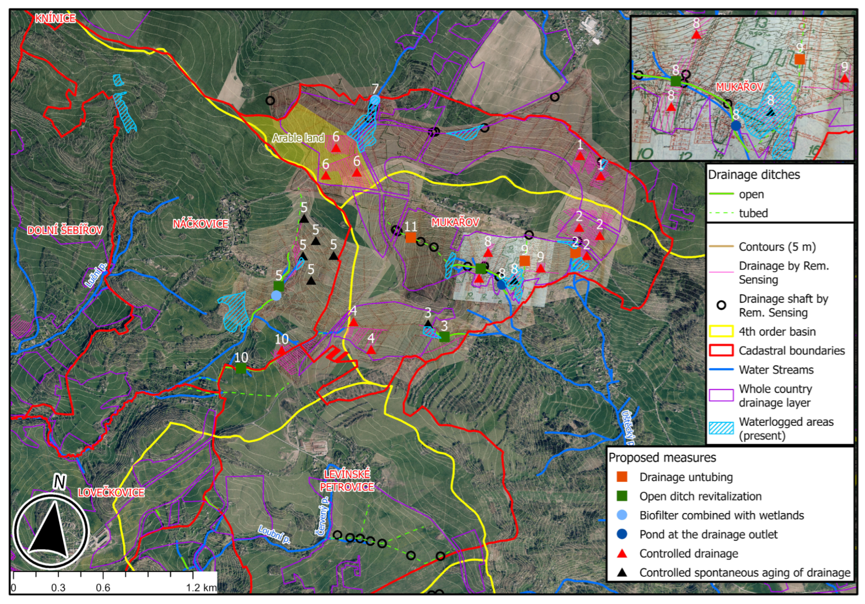
| ID | Proposed Measures | Measure Specification/Effect | No. of Land Parcels/Landowners/Land Users | Potential of Measure Implementation |
|---|---|---|---|---|
| 1 | ▲ Controlled drainage | Improvement of hay quality and yields in meadows | 14/3/1 | 2 |
| 2 | ▲ Controlled drainage | Improvement of hay quality and yields in meadows | 15/6/2 | 3 |
| ■ Drainage untubing | Stream revitalization, biodiversity support, and hay yields improvement | |||
| 3 | ■ Open ditch revitalization | Stream revitalization, biodiversity support, and hay yields improvement | 8/1/1 | 1 |
| ▲ Controlled spontaneous aging of drainage | Elimination of undue drainage, biodiversity, and water retention support | |||
| 4 | ▲ Controlled drainage | Improvement of hay quality and yields in meadows | 13/4/1 | 2 |
| ● Biofilter combined with wetlands | Improvement of water quality (potable water wells below) | |||
| 5 | ■ Open ditch revitalization ▲ Controlled spontaneous aging of drainage | Stream revitalization, biodiversity support—small pools Elimination of undue drainage, biodiversity, and water retention support | 8/3/1 | 2 |
| 6 | ▲ Controlled drainage | Improvement of hay quality and yields in meadows | 33/4/1 | 2 |
| 7 | ● Biofilter combined with wetlands | Improvement of water quality (potable water wells below), and biodiversity support | 1/1/1 | 1 |
| 8 | ■ Open ditch revitalization | Stream revitalization, biodiversity support—small pools | ||
| ▲ Controlled drainage ● Pond at the drainage outlet ▲ Controlled spontaneous aging of drainage | Improvement of hay quality and yields in meadows Support of biodiversity and water retention Elimination of undue drainage | 8/3/2 | 2 | |
| 9 | ▲ Controlled drainage | Improvement of hay quality and yields in meadows | 16/5/2 | |
| ■ Drainage untubing | Stream revitalization, biodiversity support, and hay yields improvement | 3 | ||
| 10 | ■ Open ditch revitalization | Stream revitalization, biodiversity support—small pools | ||
| ▲ Controlled drainage | Improvement of hay quality and yields in meadows | 3/2/1 | 1 | |
| 11 | ■ Drainage untubing | Stream revitalization, biodiversity support, and hay yields improvement | 4/1/1 | 1 |
Disclaimer/Publisher’s Note: The statements, opinions and data contained in all publications are solely those of the individual author(s) and contributor(s) and not of MDPI and/or the editor(s). MDPI and/or the editor(s) disclaim responsibility for any injury to people or property resulting from any ideas, methods, instructions or products referred to in the content. |
© 2025 by the authors. Licensee MDPI, Basel, Switzerland. This article is an open access article distributed under the terms and conditions of the Creative Commons Attribution (CC BY) license (https://creativecommons.org/licenses/by/4.0/).
Share and Cite
Černý, J.; Fučík, P.; Zajíček, A. Land Drainage Interventions for Climate Change Adaptation: An Overlooked Phenomenon—A Conceptual Case Study from Northern Bohemia, Czech Republic. Land 2025, 14, 782. https://doi.org/10.3390/land14040782
Černý J, Fučík P, Zajíček A. Land Drainage Interventions for Climate Change Adaptation: An Overlooked Phenomenon—A Conceptual Case Study from Northern Bohemia, Czech Republic. Land. 2025; 14(4):782. https://doi.org/10.3390/land14040782
Chicago/Turabian StyleČerný, Jiří, Petr Fučík, and Antonín Zajíček. 2025. "Land Drainage Interventions for Climate Change Adaptation: An Overlooked Phenomenon—A Conceptual Case Study from Northern Bohemia, Czech Republic" Land 14, no. 4: 782. https://doi.org/10.3390/land14040782
APA StyleČerný, J., Fučík, P., & Zajíček, A. (2025). Land Drainage Interventions for Climate Change Adaptation: An Overlooked Phenomenon—A Conceptual Case Study from Northern Bohemia, Czech Republic. Land, 14(4), 782. https://doi.org/10.3390/land14040782