Article

Perceptual-Preference-Based Touring Routes in Xishu Gardens Using Panoramic Digital-Twin Modeling

1
College of Landscape Architecture, Sichuan Agricultural University, Chengdu 611130, China
2
College of Civil and Hydraulic Engineering, Xichang University, Xichang 615013, China
3
CECEP (ChengDu) Ecological Environment Protection Industrial Co., Ltd., Chengdu 610400, China
4
College of Architecture and Urban Planning, Tongji University, Shanghai 200092, China
5
College of Architecture and Urban-Rural Planning, Sichuan Agricultural University, Chengdu 611830, China
6
School of Physics, University of Electronic Science and Technology of China, Chengdu 610054, China
*
Author to whom correspondence should be addressed.
These authors contributed equally to this work.
Land 2025, 14(5), 932; https://doi.org/10.3390/land14050932
Submission received: 29 March 2025 / Revised: 22 April 2025 / Accepted: 22 April 2025 / Published: 25 April 2025

Abstract

:
Xishu Gardens, an exemplary narrative of classical Chinese gardens, faces challenges in preserving its commemorative spatial structures while accommodating modern visitors’ needs. While trajectory analysis is critical, existing studies struggle to interpret multi-dimensional perception-preference data owing to spatiotemporal mismatches in multi-source datasets. This study adopted an improved Ward–K-medoids hybrid clustering algorithm to analyze 885 trajectory samples and 34,384 synchronized data points capturing emotional valence, cognitive evaluations, and dwell time behaviors via panoramic digital twins across three heritage sites (Du Fu Thatched Cottage, San Su Shrine, and Wangjiang Tower Park). Our key findings include the following: (1) Axial bimodal patterns: Type I high-frequency looping paths (27.6–68.9% recurrence) drive deep exploration, in contrast to Type II linear routes (≤0.5% recurrence), which enable intensive node coverage. (2) Layout-perception dynamics: single-axis layouts maximize behavioral engagement (DFTC), free-form designs achieve optimal emotional-cognitive integration (WTP), and multi-axis systems amplify emotional-cognitive fluctuations (SSS). (3) Spatial preference hierarchy: entrance and waterfront zones demonstrate dwell times 20% longer than site averages. Accordingly, the proposed model synchronizes Type II peak-hour throughput with Type I off-peak experiential depth using dynamic path allocation algorithms. This study underscores the strong spatial guidance mechanisms of Xishu Gardens, supporting tourism management and heritage conservation.

1. Introduction

As tangible carriers of heritage within cultural landscapes, visitors’ perceptual and behavioral trajectories not only reflect the narrative efficacy of heritage spaces [1] but also influence the quality of contemporary interpretations of genius loci [2]. However, rapid urbanization has intensified conflicts between tourism development and traditional conservation, leading to the widespread fragmentation of cultural experiences in historical gardens worldwide [3,4]. Contemporary research on Chinese Classical Gardens has disproportionately focused on canonical cases, often neglecting in-depth investigations of regional garden typologies. This gap is particularly evident in Xishu Gardens, an exemplary “narrative space configuration” of Chinese Classical Gardens [5]. These distinctive commemorative spatial structures face increasing deconstructive pressures due to modern tourism behaviors. In this context, scientifically planning tourism routes to balance modern visitor demands with the effective transmission of heritage value has become a critical challenge for heritage site management.
The formation of tourist activity trajectories fundamentally arises from ongoing perceptual interactions between visitors and landscape environments. Psycho-evolutionary theory elucidates individuals’ innate emotional response mechanisms to environmental stimuli, wherein these biological reactions serve as the foundation for subsequent cognition and behavior [6]. Building on this, the theory of planned behavior provides a systematic explanation of behavioral decision-making mechanisms, identifying three principal co-determinants of spatial choice patterns: attitudinal tendencies, subjective normative constraints, and perceived behavioral control [7]. Consequently, environmental features trigger a chain-reaction mechanism of “affective arousal → cognitive processing → behavioral decision-making”, ultimately shaping spatiotemporal tour path systems [8]. The unique cultural attributes of heritage sites further intensify this process [9,10]. Existing psychological and tourism studies have validated the substantial influence of attitudinal tendencies, satisfaction, loyalty, emotions, and aesthetics on tourism behaviors [11,12,13,14,15,16]. Li et al. further demonstrated that aesthetic pleasure is the predominant factor in shaping the perception of Chinese Classical Gardens’ attractiveness [17]. However, despite advancements in tourism studies [18,19], traditional perception research methods (e.g., fixed-point surveys and retrospective interviews) still face inherent data collection latency issues, which hinder the real-time capture of continuously evolving perceptual states during tours.
Contemporary research on tourism routes has led to the development of multi-dimensional analytical frameworks. Spatially, a three-tier system has been established to analyze urban networks, tourism clusters, and scenic units [20,21]. Methodologically, three notable innovative directions have emerged.
(1)
Spatiotemporal trajectory modeling using clustering analysis, ant colony optimization, and deep learning to identify path patterns [22,23,24];
(2)
Multi-objective planning integrating subjective factors (emotional attitudes and behavioral preferences) [23,25,26,27] and objective parameters (economic costs and spatial constraints) [21];
(3)
Sustainable management mechanisms for crowd control and eco-behavior guidance [28,29].
Notably, in a comparative study of trajectory data mining methods conducted in Beijing’s Forbidden City, Huang et al. demonstrated the considerable utility of clustering algorithms in spatial behavior analysis while emphasizing the need to supplement them with survey data and individual profiles to enhance model interpretability [22]. Although the current scholarship has transitioned from pure mathematical modeling to cultural–ecological coupling analysis, most route planning studies still focus on institutional stakeholders (government agencies, park operators, and research teams), thereby leaving critical gaps in public perceptual preference-oriented route design.
Current research methodologies have three major limitations.
(1)
Algorithm-driven approaches, which employ exact or heuristic search algorithms as well as deep learning [24], effectively identify visitors’ spatial distribution pattern using GPS trajectories and social media tags [22,30,31], yet fail to capture psychological dimensions such as emotional arousal levels and cognitive processing depth.
(2)
Crowd-sourced volunteer geographic information (VGI) encounters two major technical constraints in trajectory reconstruction: (a) spatial coordinate deviations and (b) temporal data discontinuities [32,33,34].
(3)
Achieving the synchronized acquisition of mobile data alongside the corresponding environmental variables remains challenging. Although Google Street View Imagery (GVI) is widely adopted as an environmental data source [35,36], its spatial coverage is significantly constrained by the physical accessibility limitations of street view collection devices.
These limitations collectively hinder spatiotemporal matching across multiple-source datasets. Disparities in measurement systems obstruct the integration of objective environmental parameters, behavioral trajectory features, and psychophysiological indicators, ultimately constraining the practical application of the emotion—cognition—behavior ternary evaluation framework. Addressing these challenges necessitates an interdisciplinary technical framework that integrates computer vision and behavioral experimentation.
In response to these methodological constraints, this study proposes a novel visual-perception-oriented theoretical framework for optimizing heritage site itineraries. The overall objective is to elucidate the multi-dimensional perceptual preference characteristics of touring routes within the heritage spaces of the Xishu Gardens by integrating perceptual indicators with visitor movement data to reveal how route typologies influence perceptual variations and inform site management strategies. Utilizing digital twin technology, three-dimensional reconstructions of heritage scenes and multivariate dynamic regulation enable the synchronous acquisition of the following multi-dimensional indicators: emotional valence (pleasure level), cognitive appraisal (aesthetic value), and behavioral response (dwell duration). This approach clarifies the coupling relationships between spatiotemporal trajectories and perceptual elements, thereby overcoming technical barriers in spatiotemporal data matching. Focusing on public perception preferences, three representative heritage sites within Xishu Gardens—Du Fu Thatched Cottage (DFTC), San Su Shrine (SSS), and Wangjiang Tower Park (WTP)—were selected as empirical cases to investigate three scientific questions:
  • The identification of perceptual preference routes using an improved Ward–K-medoids hybrid clustering algorithm.
  • The elucidation of multi-dimensional differences in perception preferences across route types.
  • The development of path selection and management strategies under an emotion–cognition–behavior synergy framework.

2. Materials and Methods

2.1. Study Area

This study focused on three national-level Cultural Heritage Protection Sites within the Xishu Gardens Heritage Site, selected for their typicality and representativeness: Du Fu Thatched Cottage (DFTC), San Su Shrine (SSS), and Wangjiang Tower Park (WTP). The selection criteria were based on the following factors: (1) conservation level (national status) [37]; (2) historical significance (as commemorative gardens for renowned figures) [38]; (3) spatial layout diversity (encompassing axial, waterfront, and linear typologies) [38]; (4) sociocultural influence (listed in China’s Tourist Attraction Catalog) [39]. Located along the Sichuan Basin cultural belt, these sites commemorate the legacies of Du Fu, the three Su scholars, and Xue Tao, collectively forming a representative sample for Xishu Garden research (Figure 1).
Although they share three fundamental spatial typologies (axial, waterfront, and linear spaces), the three case studies exhibit distinct configuration characteristics: DFTC employs a single-axis layout to reinforce hierarchical sequencing in commemorative spaces [40], SSS establishes a literati garden paradigm through a multi-axis system integrated with hydraulic networks [5], and WTP uses linear bamboo pathways to orchestrate landscape narrative rhythms [41]. This “shared typological framework with distinct configurations” provides a comparative operational framework for systematically analyzing functional expressions and perceptual responses across the three spatial types.

2.2. Methodology

This study developed a Panoramic Digital Twin System (PDTS) that integrated panoramic digital acquisition technology with environmental–behavioral analytical methods, enabling the synchronous and multi-dimensional collection of visitor behaviors and subjective evaluations. As illustrated in Figure 2, the system implemented an innovative three-phase progressive data acquisition strategy, consisting of the following steps: (1) Spatial Ontology Digitization, (2) Behavioral Process Digitization, and (3) Perceptual Data Digitization. A hybrid clustering analysis model was subsequently developed to identify typical perceptual preference route patterns. This culminated in a decision-support framework consisting of “Cluster Identification → Feature Diagnosis → Management Optimization” (Figure 2).

2.2.1. Data Acquisition and Processing

Panoramic Data Acquisition

This study utilized an Insta360 Pro2 professional six-lens panoramic camera system (Arashi Vision Inc., Shenzhen, China) for the digital acquisition of the heritage spaces. Data collection was conducted during the stable spring phenological period (25–27 April 2024) in three Xishu Gardens: the Du Fu Thatched Cottage, San Su Shrine, and Wangjiang Tower Park. To approximate a typical human eye-level perspective, the capture height was uniformly set at 150 cm. Data were acquired during low visitation periods before and after the official opening hours (07:30–10:00 and 16:30–19:00) to minimize visitor interference and illumination fluctuations.
As shown in Figure 3, the spatial sampling point layout included the following: 88 viewpoints at the DFTC, 86 for SSS, and 70 for WTP. This process ultimately generated high-resolution panoramic sequence models (7680 × 3840 pixels), establishing a high-precision digital foundation that comprehensively covered the entire study area.

Behavioral Data Capture

This study employed the digital tracking of visitor behaviors using a self-developed panoramic twin-roaming web interface. The platform introduced a Behavioral Data Acquisition System (BDAS) built on WebGL technology, thereby synchronously capturing two core behavioral datasets during participants’ free exploration: viewpoint dwell time was measured through timestamp differences between browser ‘window.onload’ and ‘window.onbeforeunload’ events, precisely recording the duration of stay at each panoramic viewpoint; visit path sequences were computed using Dijkstra’s algorithm, which executed topological reconstructions of discrete viewpoint access records [42], generating complete touring routes. To enhance virtual roaming fluency, the system optimized viewpoint-loading speed via a Content Delivery Network (CDN) and dynamically refined panoramic image resolution using level-of-detail (LOD) technology [43,44]. The platform’s questionnaire system employed background asynchronous loading, thus enabling a temporal–spatial decoupling between evaluation operations and roaming behaviors.

Perceptual Data Acquisition

This study selected pleasure, aesthetics, and immediate behavioral responses as the core measurement indicators. Data collection employed a dual-dimensional synchronous scale: the affective dimension was based on Xudong Zhang et al.’s [45] online emotion measurement approach for panoramic web interfaces, combined with Likert scale standards [46], applying a “Mood Pleasure Level” scale (1 = very negative, 5 = very pleasant) to capture real-time emotional variations during exploration. Meanwhile, the cognitive dimension applied the Scenic Beauty Estimation (SBE) method, which has a well-established application basis in landscape quality assessment [47,48], by employing a “Landscape Aesthetic Quality” scale (1 = extremely unattractive, 5 = very attractive) to quantify spatial aesthetic judgments. Compared to traditional retrospective evaluations, this study implemented continuous response logging via an embedded, simplified questionnaire system, preserving data integrity while maintaining the continuity of behavioral processes.

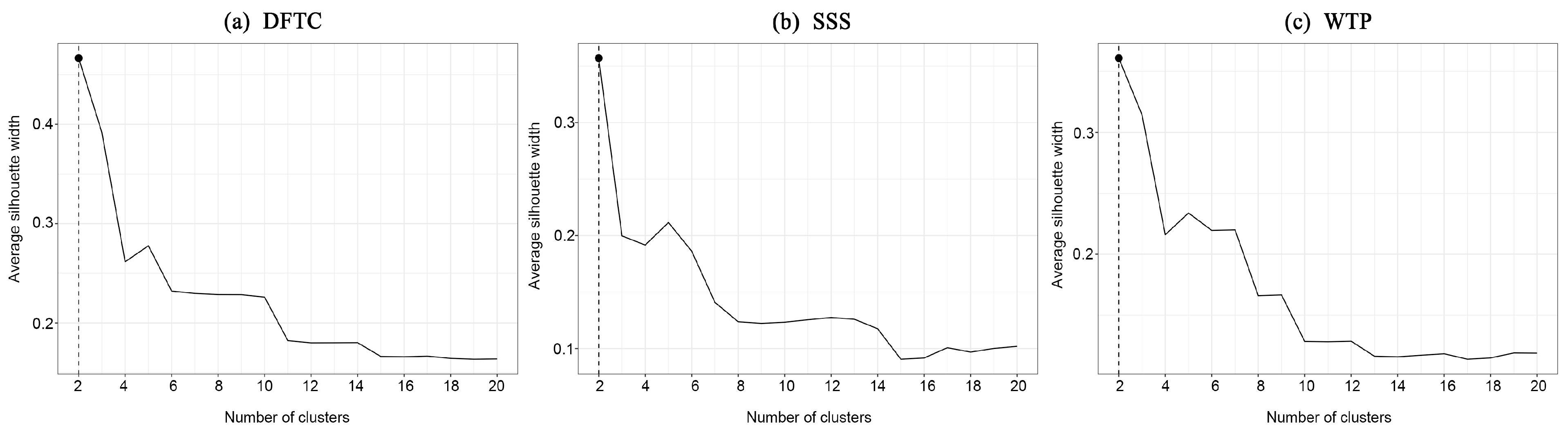
2.2.2. Tour Route Clustering Identification

Building on the sequential trajectory clustering framework proposed by Huang et al., this study introduced a hybrid clustering model that integrated hierarchical clustering and K-medoids algorithms to identify patterns in tourist behavior. The input data consisted of multi-dimensional behavioral parameters collected from the panoramic twin-roaming platform, including four characteristic variables: path sequences, landscape node pleasure levels, landscape node aesthetic quality scores, and dwell durations. These parameters were organized into string-formatted access path sequences through the ordered linking of landscape nodes as core analytical objects. Path similarity measurement was conducted using the Levenshtein edit distance algorithm, constructing a dissimilarity matrix by calculating the minimum edit operations (insertions, deletions, and substitutions) required to transform one sequence into another., Higher dissimilarity values indicated lower path-pattern similarity.
The implementation process consisted of two main phases: (1) hierarchical clustering, the initial structural partitioning of path sequences using Ward’s minimum variance method, and (2) K-medoids optimization, the iterative refinement of the initial clustering results to eliminate noise interference. The optimal number of clusters was determined by systematically comparing the average silhouette coefficients across different cluster configurations. To verify the intracluster pattern homogeneity, the Longest Common Subsequence (LCS) algorithm extracted the maximum degrees of common subsequence matching within clusters, with preset thresholds filtering valid classification results [49]. This dual-algorithm synergy balanced computational stability and noise robustness: hierarchical clustering revealed the macro-topological characteristics of trajectory distributions, whereas K-medoids clustering enhanced local cluster structure resilience against interference. The complete computational workflow was executed using the R environment (v4.4.2) to ensure methodological reproducibility and computational efficiency.

2.2.3. Experimental Protocol

This study conducted online experiments using a self-developed panoramic digital twin platform from 1 to 30 September 2024, targeting five participant categories: university students, researchers, design professionals, heritage site managers, and professionals from other industries. These groups were selected based on their demonstrated interest in and comprehension of garden heritage, ensuring a balanced sample design that integrated professional expertise and broader public engagement. The experimental workflow comprised three phases.
(1)
System Pre-Adaptation Phase
The participants underwent platform training and familiarized themselves with the protocol.
  • Cognitive Simulation Requirements: Establish a sense of virtual spatial immersion (predefined garden exploration scenarios).
  • Hardware Configuration Standards: Computer terminals with stable internet connectivity.
  • Interaction Constraints: A continuous browsing duration of at least 10 min with tab-switching operations.
(2)
Baseline Data Collection Phase
  • Demographic Characteristics: Professional category and disciplinary background (multiselection classification).
  • Experience Profiling: Historical garden visitation experience and familiarity (5-point Likert scale).
  • Ethical Compliance: Electronic informed consent forms (including data usage authorization clauses).
(3)
Free Exploration Observation Phase
  • Interaction Modality: Mouse-controlled 720° panoramic view switching and viewpoint navigation.
  • Termination Criteria: Meeting the minimum duration threshold (10 min) and manual termination triggers.
  • Data Acquisition Mechanism: Real-time logging of spatiotemporal behavior trajectories and interfacial interaction event streams.

3. Results

3.1. Descriptive Statistical Analysis

After data cleaning, a total of 885 valid observational samples were obtained, comprising 344 cases from DFTC, 279 cases from SSS, and 262 from WTP. The dataset comprised 34,384 valid behavioral records, with 12,379 entries from DFTC, 11,391 entries from SSS, and 10,614 entries from WTP. Demographic analysis revealed strong homogeneity across the three study sites regarding age distribution (19–65 years), gender ratio (39.51% male), educational attainment (with 87.6–88.7% holding a bachelor’s degree or higher), and occupational diversity. These factors met the statistical requirements for cross-regional comparative analysis (see Supplementary Table S1 for detailed distributions).
Geographic profiling revealed the predominance of local residents, accounting for 70% of the participants at DFTC, 74% at SSS, and 71% at WTP, while non-local visitors consistently accounted for 26–30% of the sample. Experience analysis demonstrated that 51% of the participants at DFTC were first-time visitors, compared to 75% of participants at both SSS and WTP.
As shown in Table 1, the three cultural parks showed a high consistency in score distribution across the three evaluation metrics: emotional pleasure, scenic beauty assessment, and dwell time. Participant ratings for both emotional pleasure and the scenic beauty assessment were predominantly concentrated at 4 points (corresponding to “relatively pleasant” and “relatively beautiful” categories), indicating generally positive emotional experiences and landscape aesthetic recognition. An analysis of median dwell times revealed distinct regional variations; participants at DFTC exhibited slightly longer median dwell times (13 s) than those at SSS (11 s) and WTP (12 s), with a broader distribution range (interquartile range [IQR] 7–26 s). In contrast, the dwell time distributions at SSS (IQR 6–19 s) and WTP (IQR 7–20 s) displayed more concentrated patterns.

3.2. Perceptual-Preference-Based Route Identification

This study employed a hybrid analytical framework integrating Ward’s hierarchical clustering and K-medoids optimization to identify visitor trajectory patterns across the three study sites. As shown in Figure 4, the silhouette coefficient analysis indicated that optimal clustering quality was achieved at K = 2, where the average silhouette coefficient for all three sites reached its maximum. This result suggests that two distinct perception-preference route clusters represent the optimal classifications for each site. The subsequent analysis of these two clusters examined four metrics: structural configuration (overall route morphology), movement frequency (node-to-node transitions), trajectory repetition rate (repeated movements/total movements), and maximum node frequency (cumulative visits to individual nodes).

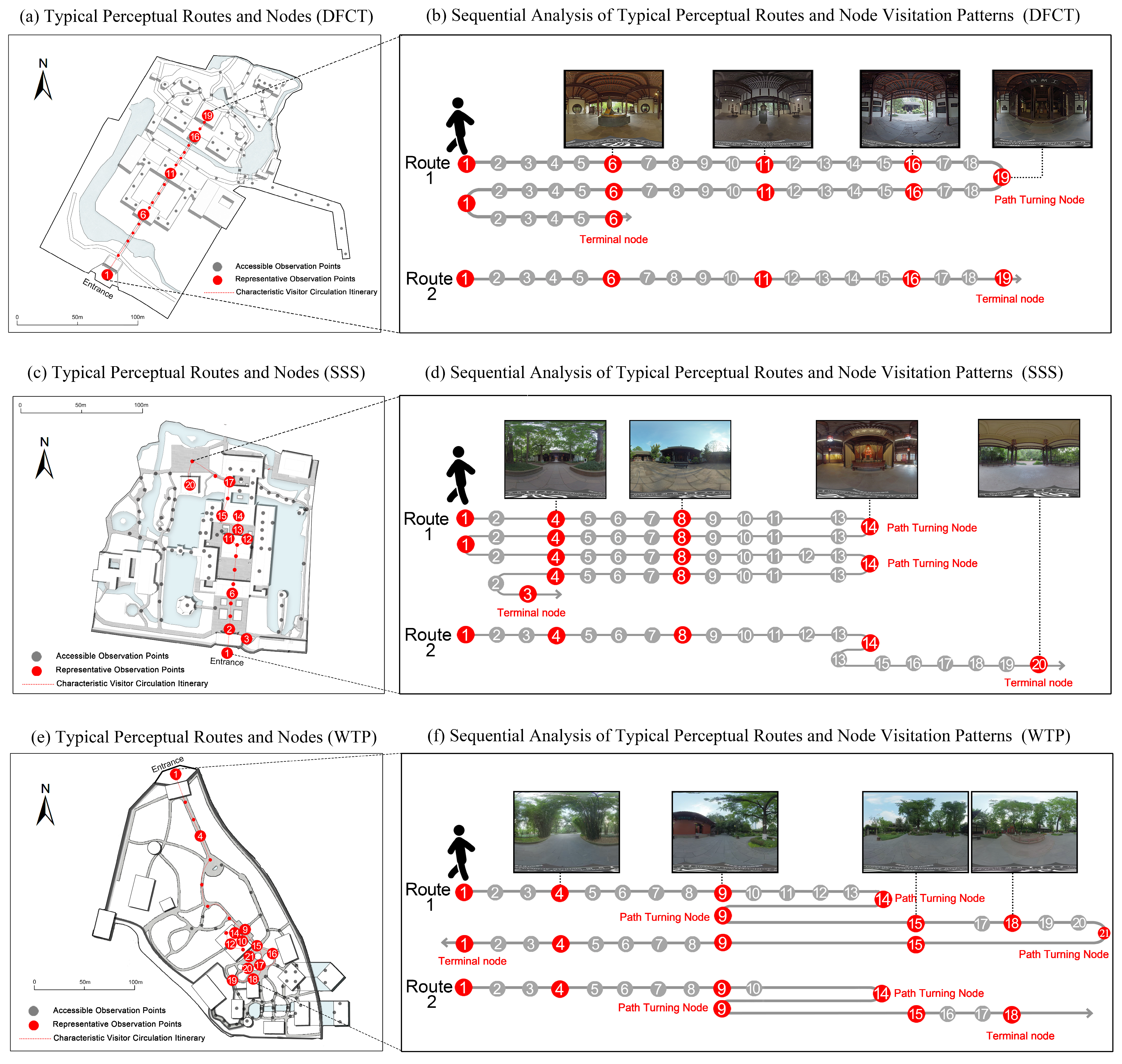
3.2.1. Du Fu Thatched Cottage

The analysis of visitor trajectories at DFTC (Figure 5a,b) revealed two spatially distinct movement patterns. Type I trajectories displayed reciprocal path characteristics, originating at Node 1 and terminating at Node 6. Node 6 functioned as a return pivot, accumulating three visits, with a reciprocal segment comprising 23 movement records (54.8% of the total). Type II trajectories presented a unidirectional linear traversal pattern, covering all 19 landscape nodes without repeated visits (Table 2).

3.2.2. San Su Shrine

As shown in Figure 5c,d, Type I trajectories at SSS exhibited a multi-loop nested path characterized by three primary reciprocal movements. The trajectory initially extended from Node 1 to Node 14, then returned to Node 1, forming the second retracement along the original path. A third reciprocal movement created a localized circular pattern between Nodes 11 and 14, ultimately extending to Node 3, a newly added terminal node. This trajectory covered all 14 landscape nodes, generating 45 movement records with a high repetition rate of 68.9% (31/45). Nodes 2, 4, 5, 6, 7, 8, 9, 10, 11, and 13 functioned as core overlapping segments (MVF = 4) supporting primary reciprocal activities. In contrast, Type II trajectories followed a unidirectional linear path with 20 total movement records. This pattern featured a single reciprocal segment between Nodes 13 and 14 and terminated at Node 20, a newly added endpoint, without further movement (Table 3).

3.2.3. Wangjiang Tower Park

As shown in Figure 5e,f, Type I trajectories at WTP exhibited a multi-branched closed-loop pattern, characterized by a movement logic that started from the core axis and returned to the origin to form a closed-loop path. Branch selection occurred at Node 9, generating brief circular branch reciprocation. As shown in Table 4, 26.7% of the 30 movement records (8 instances) involved repeated segments, reflecting a strong path dependency tendency. Type II trajectories present a hub-guided local backtracking pattern, forming a circular branch path at Node 9 before terminating at Node 18 without further movement.

3.3. Perceptual Preference Metrics Evaluation

3.3.1. Emotion–Cognition–Behavior Characteristics

The perceptual evaluation framework employed in this study integrates three key dimensions: pleasure (emotional response), aesthetic value (cognitive response), and dwell time (behavioral response). Reliability tests revealed that Cronbach’s α coefficients for the five-level Likert scale questionnaires across all three heritage sites exceeded the 0.85 threshold (DFTC: α = 0.893; SSS: α = 0.896; WTP: α = 0.908), meeting high-reliability standards (α > 0.7) and confirming their excellent internal consistency and measurement validity. As shown in Table 5, comparisons of emotion–cognition–behavior metrics between the two perceptual preference trajectory clusters at each site yielded the following results:
At DFTC, Type I trajectories (R1) showed node reciprocation (repetition rate: 56.1%, 23/41 movement records) with an average dwell time of 18.2 s, while Type II trajectories (R2) adopted linear traversal covering 19 nodes (no repetition) and yielded a notably higher dwell time of 46.6 s (Δ = +156%). Both trajectories exhibited stability across the emotional (pleasure level: 3.86 vs. 3.90) and cognitive dimensions (aesthetic value: 3.92 vs. 3.94).
SSS followed a similar behavioral differentiation pattern: Type I trajectories (R1) with multi-loop nested paths (repetition rate: 68.9%, 31/45 movement records) showed a dwell time of 13.6 s, whereas Type II trajectories (R2) with linear traversal (repetition rate: 5%) increased dwell time to 30.5 s (Δ = +124%). The aesthetic values of the two trajectory types remained nearly identical (3.98 vs. 3.97).
WTP displayed distinct behavioral differentiation compared to the other two sites: Type I trajectories (R1) with multi-branch reciprocation (repetition rate: 26.7%; 8/30 movement records) had a dwell time of 13.9 s, while Type II trajectories (R2) with localized backtracking achieved a dwell time of 34.7 s (Δ = +150%) and the highest aesthetic value across all sites (4.07 vs. 4.10).
Cross-site analysis revealed that the Type II trajectories at DFTC exhibited the longest average dwell time (46.6 s), whereas the Type I trajectories at WTP recorded the highest pleasure level, and the Type II trajectories at WTP achieved the peak aesthetic value. Furthermore, in typical Xishu-style garden spaces, the Type I trajectories consistently showed shorter dwell times than the Type II trajectories, with the ratios demonstrating convergence (DFTC, 39%; SSS, 45%; WTP, 40%). Both the emotional (pleasure level Δ ≤ 0.05) and cognitive dimensions (aesthetic value Δ ≤ 0.03) remained stable across the different trajectory types.

3.3.2. Emotion–Cognition–Behavior Spatial Distribution

As shown in Figure 6, the spatial distributions of pleasure level, aesthetic value, and dwell time (represented by mean values at observation nodes) exhibited distinct regional variations and preference patterns across the three study sites.
DFTC exhibited synchronized spatial patterns for pleasure and aesthetic value, maintaining high overall levels, with the historic site achieving the highest mean aesthetic value (4.32). Dwell time distribution deviated significantly, forming high-value clusters at the entrance and waterfront zones, where dwell times exceeded the site average by 45%.
SSS revealed the largest fluctuations in pleasure and aesthetic values but retained spatial coherence. The waterfront pavilion area emerged as the perceptual intensity core. The ancient well node displayed unique behavioral patterns: despite a lower aesthetic evaluation (SBE = 3.65), it had the longest dwell time (30.41 s), which was 76% higher than the site average.
WTP shared distribution similarities with DFTC, attaining peak mean values across all three sites for both aesthetic value (4.06) and pleasure level (4.08), with uniform spatial dispersion. The dwell time preferences were markedly concentrated at the Xue Tao Well node and waterfront area, producing spatiotemporal aggregation effects.
Comparative analysis revealed that DFTC and WTP exhibited smaller fluctuation ranges in pleasure level and SBE metrics, whereas SSS displayed greater variability (pleasure level range = 1.3; SBE range = 1.6). Dwell time patterns exhibited inverse distribution trends: DFTC recorded the highest mean dwell time (21.42 s), with its entrance node peak reaching 59.94 s—over 70% higher than peak values at SSS (17.71 s) and WTP (17.16 s). Across all three gardens, the entrance zones and waterfront areas consistently showed elevated dwell times, exceeding the garden-wide average by more than 20%.

4. Discussion

4.1. Interpretation of Perceptual-Preference Characteristics

4.1.1. Spatial Universalism of Dual-Modal Itinerary Systems

This study identified two stable itinerary patterns (K = 2 optimal solutions) along the central axes of three heritage sites, revealing marked commonalities in spatial topology characteristics and behavioral logic. These findings highlight an inherent dichotomy in visitor behavior in cultural heritage contexts: the coexistence of quality-oriented deep exploration and efficiency-oriented broad coverage. The results corroborate Yan Han’s multi-objective optimization framework for tourism route design (i.e., intensive exploration routes vs. rapid coverage routes) [21], validating the practical applicability of this dual-route system.
The comparative analysis of trajectory types revealed that all Type I itineraries exhibited complex paths with high recurrence rates (26.7–68.9%), forming closed or semi-closed structures through repeated node revisits (Table 2, Table 3 and Table 4). Such spatial repetition reinforces memory anchoring via “scene-semantic deep coding”, consistent with Burgess et al.’s theoretical framework [50]. However, this pattern incurs substantial cognitive burdens that markedly reduce behavioral efficiency: Type I trajectories show 117% higher total movement counts than Type II (DFTC: 41 vs. 18; SSS: 45 vs. 20; WTP: 30 vs. 15), directly conflicting with the “minimum action cost” principle [51]. This paradox likely arises from the heightened cognitive demands imposed by the historical–cultural attributes of heritage spaces, which override purely efficiency-driven behavioral tendencies.
Conversely, Type II trajectories (recurrence rate: 0–5%) achieved comprehensive spatial coverage through linear topological configurations. Their behavioral logic aligns with a simplified spatial decision-making model [51], wherein visitors minimize cognitive uncertainty by eliminating redundant pathways and concentrating dwell time at culturally significant nodes. This finding broadens Kaplan’s Attention Restoration Theory [52,53], showing that the breadth–depth trade-off in cultural heritage settings is regulated by the threshold mechanisms of spatial recurrence rates.

4.1.2. Synergistic Mechanisms of Affective–Cognitive–Behavioral Multi-Dimensional Responses

This study identifies selectively decoupled characteristics in the multi-dimensional perceptual responses of cultural heritage tourists. While emotional (pleasantness) and cognitive (scenic quality) perceptions exhibit steady-state spatial distributions, the behavioral dimension (mean residence time) is notably modulated by pathway complexity. The core mechanisms underlying this phenomenon can be summarized as follows.
(1)
The negative feedback between pathway complexity and behavioral efficiency.
Highly repetitive Type I pathways reinforce axial space–memory anchoring through node revisitation, inducing a cognitive load that reduces residence time to 39–45% of that observed in simplified pathways (Type II/R2). These findings suggest that tourists offset cognitive demands by reducing their dwell duration at individual points. The axial spaces dominated by architectural elements further corroborate the evidence that “urban scene exposure increases cognitive demands” [54].
(2)
The buffering effects of scene narratives on the perceptual steady state.
Despite substantial behavioral divergence (residence time variance reaching 150%), emotional (pleasantness Δ ≤ 0.05) and cognitive (scenic quality Δ ≤ 0.03) dimensions remain stable. This decoupling results from two buffering mechanisms embedded in scene narratives: (1) spatial integrity maintains aesthetic experience, ensuring overall scenic quality stability; (2) interwoven plantings offset architectural impacts, reducing negative emotions linked to “non-natural scene” cognitive loads [55].

4.2. Spatial Layouts and Perceptual Preference Itineraries

A comparative analysis revealed that historical garden spatial organization plays a key role in shaping visitor perception, with distinct path design strategies influencing dwell time, cognitive load, and emotional responses. DFTC, with its single-axis layout, establishes a spatial rhythm using an “introduction–development–transition–conclusion” narrative sequence [40]. This linear orientation significantly increases dwell time at nodal spaces but imposes a higher cognitive load due to its monotonous circulation, resulting in slightly lower emotional dimension scores (Table 5).
WTP performs strongly in both emotional and cognitive dimensions, benefiting from the synergistic coupling between its unique bamboo-dominated landscape system and free-form spatial layout [56]. Unlike axis-driven narrative spaces, bamboo groves (which occupy 63% of the garden area) interact dynamically with organic pathways due to their flexible morphological characteristics. This spatial configuration enhances the environmental perception quality via multisensory stimulation, supporting research on its therapeutic benefits [57,58].
SSS exhibits the most pronounced perceptual fluctuations (pleasure level range: 1.3 vs. <0.5 at other sites), a phenomenon directly linked to its island-dwelling water system configuration. The axial island structure generates multidirectional exploration paths [5], necessitating high-frequency backtracking for comprehensive visitation. Water boundaries improve spatial permeability via visual connectivity, while waterfront nodes foster multisensory interactions through their proximity-driven interface design. Such mechanisms jointly enhance emotional, cognitive, and behavioral metrics in riparian zones, validating the classical Chinese garden theory regarding the multisensory restorative effects of water through auditory–visual–tactile channels [59]. This phenomenon underscores the regulatory role of blue space in perceptual dynamics.

4.3. Perception-Driven Itinerary Strategies: Framework Applications and Strategic Implications

By integrating the spatial differentiation of emotional, cognitive, and behavioral responses, this study proposes a structured, hierarchical strategy featuring two distinct itinerary configurations. Type I (complex path) facilitates in-depth cultural engagement through frequent backtracking at key interpretive nodes, making it suitable for experts and repeat visitors during periods of low visitation. Type II (simplified path) adopts a linear structure to enhance immersive experiences and regulate visitor flow, thus accommodating first-time and general visitors during high-visitation periods.
To enable dynamic regulation, a tiered spatiotemporal response strategy is proposed, consisting of three operational modes: Type II during peak periods to alleviate congestion; a hybrid configuration during moderate visitation; and Type I during low-visitation periods to foster deeper engagement. In addition, a context-aware signage system and adaptive path-diversion mechanism translate dwell time variability into experiential diversity, thereby establishing a dual-objective framework that aligns heritage interpretation with visitor flow management.
The panoramic digital-twin framework proposed herein provides a lightweight and scalable solution for modeling, analyzing, and managing heritage environments. It supports decision-making processes for conservation authorities, designers, and tourism planners, particularly within medium-scale cultural landscapes. Beyond tourism, the framework facilitates preventive conservation through behavioral risk monitoring and supports immersive engagement via AR and multisensory technologies. These integrative applications contribute to the ongoing shift in heritage management from static “digital conservation” to adaptive, experience-driven governance models.
Nonetheless, several methodological limitations remain. Variability in user–device interaction may compromise data accuracy, particularly among older participants. The exclusively visual virtual environments lack multisensory inputs—ambient sound, scent, tactile feedback, and thermal cues—thereby limiting ecological validity and underrepresenting real-world experience. Future studies should combine multisensory integration with cognitive neuroscience to clarify how these microelements influence user responses. Incorporating longitudinal data (e.g., seasonal variation) would further strengthen model reliability and adaptability.

5. Conclusions

Existing research on tourism route optimization faces challenges in reconciling spatiotemporal-scale inconsistencies among multi-source datasets, limiting the synchronous interpretation of multi-dimensional perceptual preferences. This study introduces a lightweight “panoramic digital twin model” that enables the integrated acquisition of spatial, evaluative, and behavioral data. This approach facilitates the identification of perception-driven itineraries and allows for a multi-dimensional interpretation of patterns across emotional, cognitive, and behavioral dimensions. While the narrative sequencing of Chinese Classical Garden spaces is widely acknowledged, this study validates a stable dual-path trade-off mechanism between “depth exploration” and “breadth coverage”. This mechanism reflects the dynamic interplay of resource allocation and perceptual intensification in cultural heritage experiences.
In addition, the spatial differentiation of perception-driven preferences exhibited significant environmental dependency. Single-axis layouts demonstrated the highest behavioral preference, free-form layouts optimized emotional–cognitive responses, and multi-axis layouts and water-dominated spaces displayed the most pronounced variation in emotional–cognitive engagement. Building on these insights, this study advances a dual-mode itinerary collaborative regulation framework featuring a spatiotemporal coordination mechanism that prioritizes Type II route efficiency during peak periods and Type I route depth experiences during low-traffic intervals.
The outcomes not only serve as a quantitative analytical instrument for decoding visitor perception-behavior responses at the Xishu Garden Heritage Site but also offer interdisciplinary methodological implications for reconstructing the theoretical frameworks of cultural space cognition and fostering intelligent, human-centered management practices at cultural heritage destinations.

Supplementary Materials

The following supporting information can be downloaded at: https://www.mdpi.com/article/10.3390/land14050932/s1, Table S1: Descriptive statistics of sample factors. Table S2: Descriptive Statistical Analysis.

Author Contributions

Conceptualization, X.G.; methodology, X.G.; software, W.Y.; validation, X.G.; investigation, X.G., L.G. and M.L.; resources, Z.Z.; data curation, X.G., Z.Z. and L.G.; writing—original draft preparation, X.G.; writing—review and editing, Z.Z., J.L., D.Z. and M.Y.; visualization, X.G. and Y.H.; supervision, L.G.; project administration, X.G. and Y.Z.; funding acquisition, Y.Z. All authors have read and agreed to the published version of the manuscript.

Funding

This research was funded by the Industry-University-Research Collaboration Project entitled ‘Low-Carbon Lifecycle Screening of Landscape Plants and Green Industrial Park Construction Technology’, grant number CDCY2023KJCX–001. The APC was funded by Sichuan Agricultural University.

Data Availability Statement

The data collected in this study are not available due to privacy and ethical restrictions.

Acknowledgments

The authors would like to thank Bingyang Lv, Jiao Xu, Xi Chen, and Yingying Chen for their guidance in manuscript writing. Special thanks to Yongjie Zhou, Bingyan Han, Chenjing He, and Yuanxiang Huang for their assistance during the online survey process. The authors also acknowledge the support provided by the Du Fu Thatched Cottage Museum, the San Su Shrine Museum, and Wangjiang Tower Park during the panoramic data collection.

Conflicts of Interest

Author Yong Zhong was employed by the company Ecological Environment Protection Industrial Co. The remaining authors declare that the re-search was conducted in the absence of any commercial or financial relationships that could be construed as a potential conflict of interest.

Abbreviations

The following abbreviations are used in this manuscript:
DFTC—Du Fu Thatched Cottage; SSS—San Su Shrine; WTP—Wangjiang Tower Park; PDTS—Panoramic Digital Twin System; BDAS—Behavioral Data Acquisition System; CDN—Content Delivery Network; LOD—level-of-detail; SBE—Scenic Beauty Estimation; R—R environment (statistical software); VGI—volunteer geographic information; GVI—Google Street View Imagery; LCS—Longest Common Subsequence.

References

  1. Taylor, K. Cultural Landscapes and Asia: Reconciling International and Southeast Asian Regional Values. Landsc. Res. 2009, 34, 7–31. [Google Scholar] [CrossRef]
  2. Thomas, S. Heritage and Community Engagement: Collaboration or Contestation? 1st ed.; Watson, S., Waterton, E., Eds.; Routledge: London, UK, 2021; p. 19. ISBN 9781315875064. [Google Scholar]
  3. Li, M.; Wu, B.; Cai, L. Tourism development of World Heritage Sites in China: A geographic perspective. Tour. Manag. 2008, 29, 308–319. [Google Scholar] [CrossRef]
  4. ICOMOS. Heritage at Risk World Report 2016–2019: On Monuments and Sites in Danger. International Council on Monuments and Sites. 2019, p. 9. Available online: https://www.icomos.org/en/what-we-do/risk-preparedness/heritage-at-risk-reports (accessed on 18 March 2025).
  5. Guo, L.; Ma, W.; Gong, X.; Zhang, D.; Zhai, Z.; Li, M. Digital preservation of classical gardens at the San Su Shrine. Herit. Sci. 2024, 12, 66. [Google Scholar] [CrossRef]
  6. Ulrich, R.S. Aesthetic and affective response to natural environment. In Behavior and the Natural Environment; Altman, I., Wohlwill, J.F., Eds.; Springer: Boston, MA, USA, 1983; pp. 85–125. ISBN 978-1-4613-3541-2. [Google Scholar]
  7. Ajzen, I. The theory of planned behavior. Organ. Behav. Hum. Decis. Process. 1991, 50, 179–211. [Google Scholar] [CrossRef]
  8. Kaplan, R.; Kaplan, S. The Experience of Nature: A Psychological Perspective; Cambridge University Press: Cambridge, UK, 1989. [Google Scholar]
  9. Halbwachs, M. On Collective Memory; University of Chicago Press: Chicago, IL, USA, 2020. [Google Scholar]
  10. Kong, L.; Liu, Z.; Pan, X.; Wang, Y.; Guo, X.; Wu, J. How do different types and landscape attributes of urban parks affect visitors’ positive emotions? Landsc. Urban Plan. 2022, 226, 104482. [Google Scholar] [CrossRef]
  11. Del Bosque, I.R.; San Martín, H. Tourist satisfaction a cognitive-affective model. Ann. Tour. Res. 2008, 35, 551–573. [Google Scholar] [CrossRef]
  12. DeLucio, J.; Múgica, M. Landscape preferences and behaviour of visitors to Spanish national parks. Landsc. Urban Plan. 1994, 29, 145–160. [Google Scholar] [CrossRef]
  13. Hosany, S. Appraisal determinants of tourist emotional responses. J. Travel Res. 2012, 51, 303–314. [Google Scholar] [CrossRef]
  14. Gao, Y.; Zhang, T.; Zhang, W.; Meng, H.; Zhang, Z. Research on visual behavior characteristics and cognitive evaluation of different types of forest landscape spaces. Urban For. Urban Green. 2020, 54, 126788. [Google Scholar] [CrossRef]
  15. Yang, W.; Chen, Q.; Huang, X.; Xie, M.; Guo, Q. How do aesthetics and tourist involvement influence cultural identity in heritage tourism? The mediating role of mental experience. Front. Psychol. 2022, 13, 990030. [Google Scholar] [CrossRef]
  16. Li, Y.; Deng, Q.; Peng, F.; He, M. Development and verification of the wellness tourism experience scale. J. Travel Res. 2025, 64, 158–171. [Google Scholar] [CrossRef]
  17. Li, X.; Xia, B.; Lusk, A.; Liu, X.; Lu, N. The Humanmade Paradise: Exploring the perceived dimensions and their associations with aesthetic pleasure for Liu Yuan, a Chinese classical garden. Sustainability 2019, 11, 1350. [Google Scholar] [CrossRef]
  18. De Bruyn, C.; Said, F.B.; Meyer, N.; Soliman, M. Research in tourism sustainability: A comprehensive bibliometric analysis from 1990 to 2022. Heliyon 2023, 9, e18874. [Google Scholar] [CrossRef] [PubMed]
  19. Agapito, D. The senses in tourism design: A bibliometric review. Ann. Tour. Res. 2020, 83, 102934. [Google Scholar] [CrossRef]
  20. Vada, S.; Dupre, K.; Zhang, Y. Route tourism: A narrative literature review. Curr. Issues Tour. 2022, 26, 879–889. [Google Scholar] [CrossRef]
  21. Han, Y.; Guan, H.; Duan, J. Tour route multiobjective optimization design based on the tourist satisfaction. Discret. Dyn. Nat. Soc. 2014, 2014, 603494. [Google Scholar] [CrossRef]
  22. Huang, W.; Wang, L. Towards big data behavioral analysis: Rethinking GPS trajectory mining approaches from geographic, semantic, and quantitative perspectives. ARIN 2022, 1, 7. [Google Scholar] [CrossRef]
  23. Zheng, X.; You, H.; Huang, H.; Sun, L.; Yu, Q.; Luo, Y. Two-stage greedy algorithm based on crowd sensing for tour route recommendation. Appl. Soft Comput. 2024, 153, 111260. [Google Scholar] [CrossRef]
  24. Zhang, S.; Luo, Z.; Yang, L.; Teng, F.; Li, T. A survey of route recommendations: Methods, applications, and opportunities. Inf. Fusion 2024, 108, 102413. [Google Scholar] [CrossRef]
  25. Rodríguez-Díaz, B.; Pulido-Fernández, J.I. Selecting the best route in a theme park through multi-objective programming. In Tourism Spaces; Routledge: London, UK, 2021; pp. 23–41. ISBN 9781003152453. [Google Scholar]
  26. Damos, M.A.; Zhu, J.; Li, W.; Hassan, A.; Khalifa, E. A Novel Urban Tourism Path Planning Approach Based on a Multiobjective Genetic Algorithm. ISPRS Int. J. Geo-Inf. 2021, 10, 530. [Google Scholar] [CrossRef]
  27. Zheng, W.; Liao, Z.; Qin, J. Using a four-step heuristic algorithm to design personalized day tour route within a tourist attraction. Tour. Manag. 2017, 62, 335–349. [Google Scholar] [CrossRef]
  28. Ciscal-Terry, W.; Dell’Amico, M.; Hadjidimitriou, N.S.; Iori, M. An analysis of drivers route choice behaviour using GPS data and optimal alternatives. J. Transp. Geogr. 2016, 51, 119–129. [Google Scholar] [CrossRef]
  29. Schönherr, S. Tourism actors’ responsible behavior: A systematic literature review. J. Hosp. Tour. Res. 2024, 48, 671–683. [Google Scholar] [CrossRef]
  30. Liu, W.; Wang, B.; Yang, Y.; Mou, N.; Zheng, Y.; Zhang, L.; Yang, T. Cluster analysis of microscopic spatio-temporal patterns of tourists’ movement behaviors in mountainous scenic areas using open GPS-trajectory data. Tour. Manag. 2022, 93, 104614. [Google Scholar] [CrossRef]
  31. Qiao, S.; Yeh, A.G.O. Understanding the effects of environmental perceptions on walking behavior by integrating big data with small data. Landsc. Urban Plan. 2023, 240, 104879. [Google Scholar] [CrossRef]
  32. Bubalo, M.; Van Zanten, B.T.; Verburg, P.H. Crowdsourcing geo-information on landscape perceptions and preferences: A review. Landsc. Urban Plan. 2019, 184, 101–111. [Google Scholar] [CrossRef]
  33. Wang, S.; Cao, J.; Philip, S.Y. Deep learning for spatio-temporal data mining: A survey. IEEE Trans. Knowl. Data Eng. 2020, 34, 3681–3700. [Google Scholar] [CrossRef]
  34. Wang, H.; Zhi, W.; Batista, G.; Chandra, R. Pedestrian trajectory prediction using goal-driven and dynamics-based deep learning framework. Expert Syst. Appl. 2025, 271, 126557. [Google Scholar] [CrossRef]
  35. Danish, M.; Labib, S.M.; Ricker, B.; Helbich, M. A citizen science toolkit to collect human perceptions of urban environments using open street view images. Comput. Environ. Urban Syst. 2025, 116, 102207. [Google Scholar] [CrossRef]
  36. Fan, Z.; Feng, C.C.; Biljecki, F. Coverage and bias of street view imagery in mapping the urban environment. Comput. Environ. Urban Syst. 2025, 117, 102253. [Google Scholar] [CrossRef]
  37. National Government Service Platform. Available online: https://ncha.gjzwfw.gov.cn (accessed on 18 March 2025).
  38. Wei, C.; Yu, M.; Liu, F.; Chen, M.; Zhang, Q. Heritage Value Identification and Evaluation of Xishu Celebrity Memorial Garden. Chin. Landsc. Archit. 2023, 39, 127–132. [Google Scholar] [CrossRef]
  39. Sichuan Provincial Department of Culture and Tourism. Available online: https://wlt.sc.gov.cn/scwlt/c100297/introduce.shtml (accessed on 18 March 2025).
  40. Guo, L.; Xu, J.; Li, J.; Zhu, Z. Digital preservation of du fu thatched cottage memorial garden. Sustainability 2023, 15, 1359. [Google Scholar] [CrossRef]
  41. Xie, J.; Luo, S.; Furuya, K.; Kagawa, T.; Yang, M. A preferred road to mental restoration in the Chinese classical garden. Sustainability 2022, 14, 4422. [Google Scholar] [CrossRef]
  42. Turner, A.; Penn, A. Encoding natural movement as an agent-based system: An investigation into human pedestrian behaviour in the built environment. Environ. Plan. B Plan. Des. 2002, 29, 473–490. [Google Scholar] [CrossRef]
  43. Biljecki, F.; Ledoux, H.; Stoter, J. An improved LOD specification for 3D building models. Comput. Environ. Urban Syst. 2016, 59, 25–37. [Google Scholar] [CrossRef]
  44. Yaqoob, A.; Bi, T.; Muntean, G.M. A survey on adaptive 360 video streaming: Solutions, challenges and opportunities. IEEE Commun. Surv. Tutor. 2020, 22, 2801–2838. [Google Scholar] [CrossRef]
  45. Zhang, X.; Lin, E.S.; Tan, P.Y.; Qi, J.; Ho, R.; Sia, A.; Cao, Y. Beyond just green: Explaining and predicting restorative potential of urban landscapes using panorama-based metrics. Landsc. Urban Plan. 2024, 247, 105044. [Google Scholar] [CrossRef]
  46. South, L.; Saffo, D.; Vitek, O.; Dunne, C.; Borkin, M.A. Effective use of Likert scales in visualization evaluations: A systematic review. Comput. Graph. Forum 2022, 41, 43–55. [Google Scholar] [CrossRef]
  47. Daniel, T.C.; Boster, R.S. Measuring Landscape Aesthetics: The Scenic Beauty Estimation Method; USDA Forest Service Research Paper RM-167; Rocky Mountain Forest and Range Experiment Station: Fort Collins, CO, USA, 1976. [Google Scholar]
  48. Jin, W.; Zhu, B.; Fukuda, H. Research on ancient town style construction strategies based on coupled quantitative analysis of AI visual recognition and scenic beauty evaluation. Front. Archit. Res. 2025, 14, 654–671. [Google Scholar] [CrossRef]
  49. Bergroth, L.; Hakonen, H.; Raita, T. A survey of longest common subsequence algorithms. Proc. Int. Symp. String Process. Inf. Retr. 2000, 7, 39. [Google Scholar] [CrossRef]
  50. Burgess, N.; Maguire, E.A.; O’Keefe, J. The human hippocampus and spatial and episodic memory. Neuron 2002, 35, 625–641. [Google Scholar] [CrossRef] [PubMed]
  51. Zipf, G.K. Human Behavior and the Principle of Least Effort: An Introduction to Human Ecology; Ravenio Books; American Sociological Association: Washington, DC, USA, 2016. [Google Scholar]
  52. Kaplan, S. The restorative benefits of nature: Toward an integrative framework. J. Environ. Psychol. 1995, 15, 169–182. [Google Scholar] [CrossRef]
  53. Ohly, H.; White, M.P.; Wheeler, B.W.; Bethel, A.; Ukoumunne, O.C.; Nikolaou, V.; Garside, R. Attention Restoration Theory: A systematic review of the attention restoration potential of exposure to natural environments. J. Toxicol. Environ. Health Part B 2016, 19, 305–343. [Google Scholar] [CrossRef] [PubMed]
  54. Amboni, M.; Barone, P.; Hausdorff, J.M. Cognitive contributions to gait and falls: Evidence and implications. Mov. Disord. 2013, 28, 1520–1533. [Google Scholar] [CrossRef]
  55. Burtan, D.; Joyce, K.; Burn, J.F.; Handy, T.C.; Ho, S.; Leonards, U. The nature effect in motion: Visual exposure to environmental scenes impacts cognitive load and human gait kinematics. R. Soc. Open Sci. 2021, 8, 201100. [Google Scholar] [CrossRef]
  56. Huan, L.; Chen, M.; Zhang, Q.; Li, Y.; Wu, Y. Research on the Aesthetic Construction Method of Block Park Scenes under the Concept of Scenes City Management: A Case Study of Wangjianglou Block in Chengdu. Chin. Landsc. Archit. 2022, 38, 47–52. [Google Scholar] [CrossRef]
  57. Lyu, B.; Zeng, C.; Deng, S.; Liu, S.; Jiang, M.; Li, N.; Chen, Q. Bamboo forest therapy contributes to the regulation of psychological responses. J. For. Res. 2019, 24, 61–70. [Google Scholar] [CrossRef]
  58. Zeng, C.; Lyu, B.; Deng, S.; Yu, Y.; Li, N.; Lin, W.; Chen, Q. Benefits of a three-day bamboo forest therapy session on the physiological responses of university students. Int. J. Environ. Res. Public Health 2020, 17, 3238. [Google Scholar] [CrossRef]
  59. Guo, L.; Gong, X.; Li, Y.; Zhang, D.; Elsadek, M.; Yun, J.; Ahmad, H.; Yao, M.; Li, N. Multisensory Health and Well-Being of Chinese Classical Gardens: Insights from Humble Administrator’s Garden. Land 2025, 14, 317. [Google Scholar] [CrossRef]
Figure 1. Geographical location and plan maps of study area.
Land 14 00932 g001
Figure 2. Research framework.
Land 14 00932 g002
Figure 3. Spatial distribution map of panoramic image acquisition sites.
Land 14 00932 g003
Figure 4. Silhouette coefficient analysis plot. Note: K-medoids (PAM) algorithm iteratively applied to k-values ranging from 2 to 20.
Land 14 00932 g004
Figure 5. Spatial configuration and sequential patterns of clustered travel routes at each site.
Land 14 00932 g005
Figure 6. Spatial heat map of perceptual preference metrics across three sites. Note: Metrics characterized by average values of pleasure/scenic quality/dwelling duration at each sampling node.
Land 14 00932 g006
Table 1. Descriptive statistics of perceived preference indicators.
CharacteristicDFTC
N = 12,379
SSS
N = 11,391
WTP
N = 10,614
Pleasure Level
177 (0.6%)18 (0.2%)10 (<0.1%)
2255 (2.1%)192 (1.7%)130 (1.2%)
33563 (29%)2891 (25%)2281 (21%)
45771 (47%)5295 (46%)5016 (47%)
52713 (22%)2995 (26%)3177 (30%)
Beauty Estimation
142 (0.3%)19 (0.2%)7 (<0.1%)
2378 (3.1%)263 (2.3%)122 (1.1%)
33335 (27%)2750 (24%)2186 (21%)
45504 (44%)5171 (45%)4810 (45%)
53120 (25%)3188 (28%)3489 (33%)
Count time13 (7, 26)11 (6, 19)12 (7, 20)
Note: n (%); median (Q1, Q3).
Table 2. Comparison of clustered tour route structures at DFTC.
ParametersRoute IRoute II
Tour Route StructureBidirectional Reciprocal StructureUnidirectional Linear Structure
Total Movement Count4118
Trajectory Repetition Rate0.561 (23/41)-
Maximum Visit Frequency at a NodeNode 2/3/4/5/6 (MVF = 3)All nodes (MVF = 1)
Note: Maximum Visit Frequency (MVF).
Table 3. Comparison of clustered tour routes at SSS.
ParametersRoute IRoute II
Tour Route StructureNested Recursive StructureLocal Recursive Circuit
Total Movement Count4520
Trajectory Repetition Rate0.689 (31/45)0.05 (1/20)
Maximum Visit Frequency at a NodeNode 2\4\5\6\7\8\9\10\11\13 (MVF = 4)Node 13 (MVF = 2)
Table 4. Comparison of clustered tour routes at WTP.
ParametersRoute IRoute II
Tour Route StructureBranched Loop ConfigurationLocal Recursive Circuit
Total Movement Count3015
Trajectory Repetition Rate0.267(8/30)0
Maximum Visit Frequency at a NodeNode 9 (MVF = 3)Node 9 (MVF = 2)
Table 5. Mean scores of affective–cognitive–behavioral dimensions in clustered route groups.
CharacteristicDFTCSSSWTP
Route 1Route 2Route 1Route 2Route 1Route 2
Significance3.863.93.973.934.064.01
Beauty3.923.943.983.974.074.10
Dwell time18.246.613.630.513.934.7
Note: The metrics are characterized by the mean values of the corresponding clustered route groups.
Disclaimer/Publisher’s Note: The statements, opinions and data contained in all publications are solely those of the individual author(s) and contributor(s) and not of MDPI and/or the editor(s). MDPI and/or the editor(s) disclaim responsibility for any injury to people or property resulting from any ideas, methods, instructions or products referred to in the content.

