Article

Spatiotemporal Effects and Driving Factors of Ecosystem Services Trade-Offs in the Beijing Plain Area

1
School of Landscape Architecture, Beijing Forestry University, Beijing 100083, China
2
Hangzhou International Urbanology Research Center & Zhejiang Urban Governance Studies Center, Hangzhou 311121, China
*
Author to whom correspondence should be addressed.
Land 2025, 14(5), 949; https://doi.org/10.3390/land14050949 (registering DOI)
Submission received: 18 March 2025 / Revised: 19 April 2025 / Accepted: 25 April 2025 / Published: 27 April 2025

Abstract

:
Identifying the spatiotemporal variations in and driving factors of trade-offs and synergies among ESs in the plain area forms a critical foundation for the effective management of ecosystems and regulation. It is also crucial for effectively distributing the management of natural assets and the formulation of effective ecological policy. This research utilized correlation analysis, GWR and OPGD to examine the trade-offs and synergies among Net Primary Production, Soil Carbon, Water Conservation, and Habitat Quality in the Beijing Plain from 2001 to 2020. The results revealed that from 2001 to 2020, HQ and SC showed a declining trend, while NPP and WC exhibited an increasing trend. The trade-off intensities among NPP-SC, NPP-WC, and WC-HQ increased, whereas the trade-off intensities among NPP-HQ, SC-HQ, and SC-WC decreased. High-synergy areas for NPP-HQ, SC-HQ, and SC-WC were focused in the central urban area, with scattered distribution in the southeast and northwest. NPP-SC displayed a fragmented spatial distribution with significant variations. The spatiotemporal distributions of NPP-WC and WC-HQ were highly similar, both exhibiting strong synergy. However, NPP-WC demonstrated strong trade-offs in the northern plain area but weaker trade-offs elsewhere, while WC-HQ exhibited strong trade-offs outside the central urban area. The kind of land use was the primary element affecting the trade-off intensities of NPP-HQ, SC-HQ, and WC-HQ. NDVI and precipitation significantly influenced NPP-SC. The key factors influencing the spatial variation in NPP-WC were the land use type, temperature, and precipitation. Temperature was the primary determinant affecting SC-WC. The trade-off intensity among ESs is not determined by a single factor but is driven by the interactions between services or shared influencing factors, exhibiting high spatial heterogeneity. These findings provide valuable guidance for developing strategies for land-use planning and ecological restoration.

1. Introduction

Ecosystem services (ESs) refer to the various functions and products that natural ecosystems provide, either directly or indirectly, to improve human well-being, including supplying, regulating, and cultural services. These services constitute the fundamental basis and environmental prerequisites vital for sustaining human life and progress [1,2,3]. In a broader sense, the advantages humans derive from ecosystems can also be classified as “ecosystem services” [4]. Globally, ecological functions are substantially affected by variables such as land use types [5], climate change [6,7,8,9], biological communities [10], human activities [11], and socio-economic conditions [12]. Numerous nations have prioritized the safeguarding and supply of ESs [13]. The investigation of ESs typically focuses on three aspects: monetary valuation, supply–demand balance and flows, and trade-offs and synergies [14,15,16]. Ecosystems exhibit complex non-linear interactions, and compromises and collaborations often exist among various services. Trade-offs arise when an enhancement in one or more services results in a decline in others, whereas synergies denote the concurrent growth or decline of two or more services [17].
Identifying compromises and collaborations among ESs has long been a fundamental subject in ecology, geography, and relevant fields [18]. Trade-off analyses are frequently applied to various geomorphic environments globally, including plateaus [19,20], basins [21], estuaries [22,23,24], and mountains [25]. The majority of research has been on trade-offs and synergies at a single or static time node, with relatively limited research on plains with poor ecological conditions. With recent advances in emerging technologies, quantitatively measuring the impact of various ESs on trade-offs has become increasingly important [17,26]. Many scholars have applied methods such as analysis of correlation [27,28], cluster analysis [29], and regression analysis [30,31] to identify the key factors driving spatiotemporal changes in ecological environments and to analyze the interactions and compromises among ESs. However, the aforementioned methods struggle to reveal the regional heterogeneity of the ES nexus, and the current literature is deficient in comprehensive studies regarding the effects of social, economic, and climatic factors. To better understand the effect of spatial configuration changes on trade-offs in ESs, a growing quantity of scholars have commenced using geographic detectors to explore the interactions among multiple motivating factors and the impact of each factor. For example, Li et al. [32] employed the OPGD model to systematically diagnose and identify the factors affecting ESs in Puding County. Zhang et al. [33] integrated the GeoDetector and GeoDa models to investigate how ecosystem services respond to eleven influencing factors. Li et al. [34] applied GeoDetector to quantitatively evaluate the driving effects of natural conditions and human activities on the long-term variation and spatial distribution of soil erosion rates. In addition, Song et al. [35] optimized the parameters of the GeoDetector model and developed an OPGD model for spatial stratified heterogeneity analysis. Nevertheless, traditional geographic detectors face limitations due to suboptimal parameter selection during the discretization of independent variables. The optimal parameter geographic detector addresses this issue by determining the best classification method for the data, significantly improving the accuracy of analysis.
Beijing, as China’s political, economic, and cultural center, is among the most heavily populated regions globally. In a 1907 publication, American geologist Bailey Willis referred to the small plain on which Beijing is located as the “Northern Plain Bay” or “Beijing Bay” [36]. The Beijing Plain serves not only as the city’s economic development hub but also holds significant ecological value within the Beijing–Tianjin–Hebei region. Urban areas depend on external ecosystems while benefiting from the ESs generated within [4]. Since the onset of the 21st century, the Plains have experienced population growth, a housing surge, and heightened demographic and economic activity. These trends have resulted in increased carbon emissions and reduced carbon sequestration [37,38,39]. Quantifying Net Primary Productivity (NPP) is an ecosystem service that is essential for the well-being of inhabitants in the plain area [40]. Additionally, the original ecological areas outside urbanized plains face challenges including soil erosion [41], a diminished water conservation capacity [42], and the degradation of habitat quality [43].
Conflicts among ESs arise from various factors, including anthropogenic activity and natural environmental conditions. The Beijing Plain, as a shared habitat for all living organisms, supports diverse natural and non-natural elements [44]. Quantifying the spatiotemporal development characteristics of the biological environment of the Beijing Plain and analyzing the compromises and collaborations of ecosystem service providers from a holistic and integrated perspective are crucial for assessing ecological service relationships during the development of the plain area and the entire North China Plain. This approach enhances the understanding of ecosystem functions and values, promotes sustainable ecosystem management, and facilitates the sustainable utilization of socio-ecological systems to maximize human welfare [45]. This study examines four ecological services (Net Primary Productivity, Soil Conservation, Water Conservation and Habitat Quality) that were selected to attain the subsequent objectives: (1) Identify the dynamical distribution patterns and trends in ecosystem service trade-offs in Beijing from 2001 to 2020. (2) Measure the degree of compromises among ESs. (3) Investigate the mechanics by which social, economic, and climatic factors influence the magnitude of trade-offs among ecosystem functions. (4) Provide targeted recommendations for ecological optimization and urban development in the Beijing Plain area.

2. Materials and Methodology

2.1. Study Area

Beijing (39°44′–41°06′ N, 115°42′–117°51′ E) is encircled by mountains on three sides, with terrain sloping from northwest to southeast at an altitude of 20–60 m. The Beijing Plain, a typical alluvial plain in the westernmost of the North China Plain, includes the southeastern plain area and the northwestern Yanqing Basin, encompassing an area of approximately 6338 square kilometers. This region features a warm, moderate, semi-humid continental monsoon climate, with an average annual temperature of 11.6 °C and an irregular spatial distribution of yearly precipitation.
Under these climatic conditions, the Beijing Plain is a core area suitable for urban development, and its ecological services directly influence the ecosystem well-being of 70% of Beijing’s residents. Based on Beijing’s spatial characteristics and urban master planning, the Beijing Plain is defined as areas below 100 m in altitude (Figure 1). Future ecological restoration in this region will be guided by five dominant functional types: water conservation, soil conservation, biodiversity maintenance, agricultural production, and human habitat construction. These will be tailored to address the city’s natural background and ecological issues.

2.2. Data Sources and Preprocessing

(1) Land Use Data: Land use classification data for 2001, 2006, 2011, 2016, and 2020 were sourced from the CLCD dataset developed by Yang Jie’s team. This dataset, based on the GEE platform, utilized a random forest classifier for categorization. Post-processing techniques, such as spatiotemporal filtering and logical reasoning, were utilized to enhance the consistency in spatiotemporal dimensions. The spatial precision of the dataset is 30 m [46]. (2) Soil Data: The proportions of sand, clay, and loam were acquired from China’s soil map in the World Soil Database (HWSD-ver1.2). The soil organic matter, soil texture, and soil type composition were obtained from a 1:1,000,000-scale soil dataset. Root depth data for vegetation came from the Depth to Bedrock (DTB) dataset for China, with a resolution of 100 m. (3) DEM Data: DEM data for Beijing were sourced from the Geospatial Data Cloud at http://www.gscloud.cn/ (accessed on 24 December 2023), with a spatial resolution of 30 m. (4) NDVI Data: NDVI data for the China region were derived from the MOD13Q1 NDVI dataset supplied by NASA’s Earth Data Center at https://earthdata.nasa.gov/ (accessed on 24 December 2023). The dataset possesses a spatial resolution of 250 m and a temporal series spanning 2000–2020. (5) Meteorological Data: Meteorological data for Beijing Plain and its surrounding areas were obtained for 2000 to 2020. Data on the monthly precipitation, mean monthly temperature, sunshine length, and total monthly solar radiation were obtained from the National Earth System Science Data Center at http://www.geodata.cn (accessed on 24 December 2023). Data for China’s potential evapotranspiration were sourced from the National Tibetan Plateau Scientific Data Center at http://www.ncdc.ac.cn (accessed on 24 December 2023) and were processed through spatial interpolation to achieve a resolution of 1 km. (6) Administrative Vector Boundary Data: Administrative boundary data were sourced from the Resource and Environment Science and Data Center of the Chinese Academy of Sciences at https://www.resdc.cn (accessed on 24 December 2023). (7) Population Density Data: Population density statistics were sourced from WorldPop at https://www.worldpop.org/ (accessed on 24 December 2023), with a spatial resolution of 1000 m. All raster files were ultimately resampled to a spatial resolution of 30 m and a projected coordinate system of WGS 1984 Albers.

2.3. Research Approaches

2.3.1. Measurement of ESs

(1)
Net Primary Production
NPP represents the net carbon sequestration by plants, calculated in contrast to carbon dioxide absorption during photosynthesis and its release during respiration. NPP is estimated from two variables: APAR and actual light use efficiency [47]. In this research, the improved CASA model was utilized to compute NPP. This model is characterized by its ability to eliminate the errors introduced by remote sensing data sources in vegetation NPP simulations from a remote sensing data processing perspective and to simulate the optimal light utilization efficiency of predominant vegetation species [48].
N P P   ( x , t ) = A P A R   ( x , t ) × ε ( x , t )
where N P P   ( x , t ) represents the net primary productivity of vegetation during time period ton (g C·m−2·a−1); A P A R   ( x , t ) denotes the absorbed photosynthetically active radiation (MJ·m−2); and ε ( x , t ) refers to the actual luminous efficacy (g·MJ−1).
(2)
Soil Conservation
Within this research, we employed the RUSLE within the Sediment Delivery Ratio module to assess the potential and existing soil erosion in the Beijing Plain [49]. The amount of soil conservation within the environment is computed by calculating the difference between the prospective soil erosion and actual soil erosion.
A p = R × K × L × S
A r = R × K × L × S × C × P
A S C = A p A r = R × K × L S × ( 1 C × P )
where A S C is the SC ( t   h a 1 y r 1 ) ; A p is the amount of potential soil erosion ( t   h a 1 y r 1 ) ; and A r is the amount of actual soil erosion ( t   h a 1 y r 1 ) . R is the rainfall erosivity ( M J m m ( h a h r y r ) 1 ) , for which the monthly values were computed with the methodology suggested by Wischmeier et al. [50]; K is the soil erodibility factor ( t h a h h a M J 1 m m 1 ) ; and LS is a dimensionless slope length gradient factor. C is a dimensionless cover-management factor, and P is a dimensionless support practice factor.
(3)
Water Conservation
The water conservation module of the InVEST model is derived from the Budyko curve equation. It utilizes inputs such as the annual average precipitation, annual potential evapotranspiration, vegetation type, soil depth, and plant-available water content to estimate water conservation.
Y ( x ) = 1 A E T x P x × P ( x )
A E T ( x ) P ( x ) = 1 + P E T ( x ) P ( x ) 1 + P E T ( x ) P ( x ) ω 1 / ω
P E T ( x ) = K c l x E T 0 ( x )
ω ( x ) = Z A W C ( x ) P ( x ) + 1.25
where Y x is the annual WY of ecosystem type grid x (mm). A E T x is the annual actual evapotranspiration (mm) for pixel x and P x is the annual precipitation (mm) on pixel x. P E T ( x ) is the potential evapotranspiration (mm). E T 0 ( x ) is the reference evapotranspiration from pixel x. ω ( x ) is a non-physical parameter that characterizes the natural climatic–soil properties. A W C ( x ) is the volumetric (mm) plant-available water content. Z is an empirical constant, occasionally designated as the “seasonality factor”, that delineates the regional precipitation pattern and additional hydrogeological characteristics.
(4)
Habitat Quality
This study examines the Habitat Quality module of the InVEST model to quantitatively evaluate the potential habitat quality inside the Beijing Plain area. The model is predicated upon land use data and relevant factors threatening biodiversity to assess the habitat’s integrity, reflecting the biodiversity status of the study area and its potential ability to provide living conditions for species [51]. The habitat quality values go from 0 to 1, with elevated values signifying a superior habitat quality and lower values representing a poorer habitat quality. The formula for calculation is as follows:
Q x j = H j 1 D x j z D x j z + k z
where Qxj represents the habitat quality of grid x within habitat type j; Hj denotes the habitat suitability of habitat type j; and Dxj refers to the habitat degradation index of grid x within habitat type j. The k constant is the half-saturation constant, which is usually half of the maximum value of the degradation index. z (system hard code z = 2.5) is a scaling parameter.
All of these models are spatially explicit approaches that, when integrated with high-resolution remote sensing and multi-source geographic data, can effectively capture spatial variability in regional climate gradients, topographic heterogeneity, and the intensity of human activities. They enable the precise identification of service hotspots, trade-off conflict zones, and priority areas for ecological restoration, thereby providing a spatial basis for refined management and policy intervention.

2.3.2. ESs Analysis of Trade-Offs and Synergies

(1)
Method of Evaluation for Trade-offs and Synergies
According to the normal distribution characteristics of ESs values, a 1 km × 1 km ecological grid was erected in ArcGIS, and incomplete grids along the plain area boundary were removed using the clipping tool. The standardized values of individual ESs were extracted to the grid center points over the study period. Subsequently, the correlations among Net Primary Productivity, Habitat Quality, Soil Conservation, and Water Conservation were calculated on the R 4.3.2 platform using Pearson correlation coefficients, correlation testing functions, and Spearman correlation coefficients. The significance of the correlations was tested using the p-value [52,53]. If there was a significant negative or positive correlation between the two services at p < 0.05, it meant that there were meaningful trade-offs or synergistic connections [54].
A further analysis of the temporal dynamics of ESs was conducted using the MATLAB 2023b platform. Spatial analysis was conducted on a pixel-by-pixel basis inside the grid to assess the extent of trade-offs or synergies across ESs using correlation coefficients [55]. A t-test was employed to evaluate the relevance of the geographic intensity of trade-off/synergy effects among ESs. If p < 0.01, the trade-off/synergy achieved a highly significant result; if 0.01 < p < 0.05, the link was deemed significant. Pixel-level measurement adds more information to the overall picture of how ESs work together and against each other.
(2)
Trade-offs and Synergies Intensity
GWR was utilized to measure the trade-offs and synergies among ESs at the spatial level. Unlike traditional linear regression models, which estimate parameters using the least squares method, spatial autocorrelation among Net Primary Productivity, Soil Conservation, Water Conservation and Habitat Quality violates the assumption of residual independence, rendering linear regression unsuitable for estimating spatial relationships. GWR, proposed by Brunsdon et al. [56], is a local regression method that incorporates spatial location information as a variable in the calculations. By utilizing observed values from surrounding data, GWR evaluates the spatial interactions between variables.
  • The basic formula is as follows:
y i = β 0 μ i , v i + k = 1 p   β k μ i , v i x i k + ε i
where μ i , v i represents the geographic coordinates of point i . p denotes the number of independent variables. y i ,   x i and ε i represent the dependent variable, independent variable, and random error at point i , respectively. β 0 μ i , v i and β k μ i , v i are the intercept and slope of the model at regression point i , respectively.
  • The parameters can be estimated using the following formula:
β μ i , v i = X T W μ i , v i X 1 X T W μ i , v i Y
where β μ i , v i represents the unbiased estimate of the regression coefficient at point i .   W μ i , v i is the spatial weight matrix, where weights increase with distance from the central point. X and Y represent the matrices of independent variables and dependent variables, respectively.
  • The weights are determined using the Gaussian spatial kernel function, expressed as follows:
ω i j = e x p   d i j 2 b 2
where ω i j represents the weight of point j . d i j is the Euclidean distance between points i and j . b is the bandwidth. In this study, a 1 km × 1 km grid was created, and 5773 samples were extracted for GWR analysis. The implementation of GWR was primarily conducted using R 4.3.2, with the bandwidth optimized based on Akaike Information Criterion corrected (AICc).

2.3.3. Analysis of ESs Driving Factors

GeoDetector is a novel technique for identifying spatial variability and its influencing factors, and is extensively utilized to examine the mechanisms of effect from ecological and urban–rural economic factors. In this paper, the strength of ESs trade-off is the dependent variable, while the other influencing factors are independent variables. Factor detection and interaction detection were utilized to assess the explanatory capacity of individual components and their combinations regarding the geographical heterogeneity of ESs trade-offs. Using the q-value (spanning from 0 to 1), GeoDetector quantifies each factor’s explanatory power over trade-off intensity. Interaction detection evaluates whether the interplay between two factors enhances or reduces the explanatory power of the trade-off intensity. There exist five distinct sorts of relationships: non-linear weakening, unilateral non-linear weakening, bi-factor enhancement, independence, and non-linear enhancement [57,58].
The Optimal Parameter Geodetector (OPGD) builds upon the traditional Geodetector by optimizing spatial discretization and parameter selection to identify the most suitable spatial heterogeneity. When applied to ecosystem service trade-off analysis, OPGD can more accurately identify the dominant factors driving ecological trade-offs. For example, in analyzing trade-off relationships such as “WC–SC”, the model improves the explanatory power of driving forces by optimally distinguishing spatial units, thereby clarifying which variables best account for the spatial heterogeneity in trade-off patterns. In addition, through its automatic parameter adjustment mechanism, OPGD is well-adapted to local characteristics across different spatial scales and heterogeneous regions, making it highly applicable to varied ecological contexts including urban, suburban, and mountainous areas. Most importantly, by eliminating the subjectivity of manual parameter selection, OPGD ensures a reproducible optimization process that strengthens the comparability and scientific validity of spatial trade-off analyses in ecosystem service research. This study utilized five methods—equal interval, natural breakpoint, quantile, geometric interval, and standard deviation—based on R 4.3.2 to identify the best parameter combination. The class range was established at 3–7, and the OPGD model employed the approach with the highest q-value to identify and assess the driving factors impacting the intensity of trade-offs in the Beijing Plain [9]. Finally, based on previous research and the region’s actual conditions, seven influencing factors, including socio-economic and climatic variables, were selected for analysis (Table 1) [59,60,61].

3. Results

3.1. Spatiotemporal Heterogeneity of ESs

Between 2001 and 2020, the general trends for Net Primary Productivity (NPP), Soil Conservation (SC) and Water Conservation (WC) in the plain area were upward, with growth rates of 47%, 50%, and 34% (Figure 2). In contrast, Habitat Quality (HQ) remained relatively stable throughout the same period. The notable improvement in vegetation coverage across the Beijing Plain can be largely attributed to the Beijing–Tianjin Sandstorm Source Control Project, launched in 2000, which implemented large-scale afforestation, cropland-to-forest conversion, and grassland management. These ecological interventions significantly enhanced both NPP and WC. In addition, the implementation of the South-to-North Water Diversion Project (central route) has also played a critical role. Since 2014, water transfer to northern China has alleviated groundwater overexploitation, improved regional water conditions, and contributed to the enhancement of water conservation capacity. As a result, WC exhibited a marked increase in 2016, reaching a peak value of 842 mm.
However, the observed downward trends in HQ and SC across much of the study area can be attributed to intensified agricultural activities in some regions, driven by the need to meet urban food demand. This has led to increased soil erosion and habitat fragmentation, thereby reducing soil retention and habitat quality. Moreover, despite the introduction of ecological protection policies, the delayed implementation of restoration and conservation measures in certain areas has failed to effectively curb ongoing ecological degradation. ESs in the plain area of Beijing exhibit significant spatial differentiation, shaped by the combined effects of natural ecological conditions and human activities. In terms of spatial patterns, high values of NPP and WC are primarily distributed in the eastern, northern, and southwestern parts of the plain. These areas are often located on the urban fringe or within key ecological project zones, characterized by higher vegetation cover and favorable hydrological conditions, reflecting the effectiveness of ecological restoration and greening policies. In contrast, high-value areas of HQ are mainly concentrated along the periphery of the plain, while the urban core shows low HQ values due to high-density development and habitat fragmentation. SC presents a fragmented pattern, with alternating high and low values. High SC values are generally found on piedmont slopes and near water bodies, where topography, soil properties, and vegetation jointly exert significant influence. Various forms of construction, such as road building and real estate development, have frequently disturbed the soil, particularly in transitional zones, resulting in a more fragmented landscape. Overall, NPP and WC exhibit highly consistent spatial distributions, with values generally decreasing from the urban periphery toward the core. In contrast, HQ demonstrates the opposite trend. Regarding temporal dynamics, the most significant improvements in ESs have occurred in the eastern Tongzhou sub-center and the southwestern districts of Fangshan and Fengtai. These trends reflect the positive effects of recent urban green transformation initiatives, ecological buffer zone construction, and the implementation of ecological protection policies in enhancing regional ecosystem functionality.

3.2. ESs Trade-Offs and Synergies

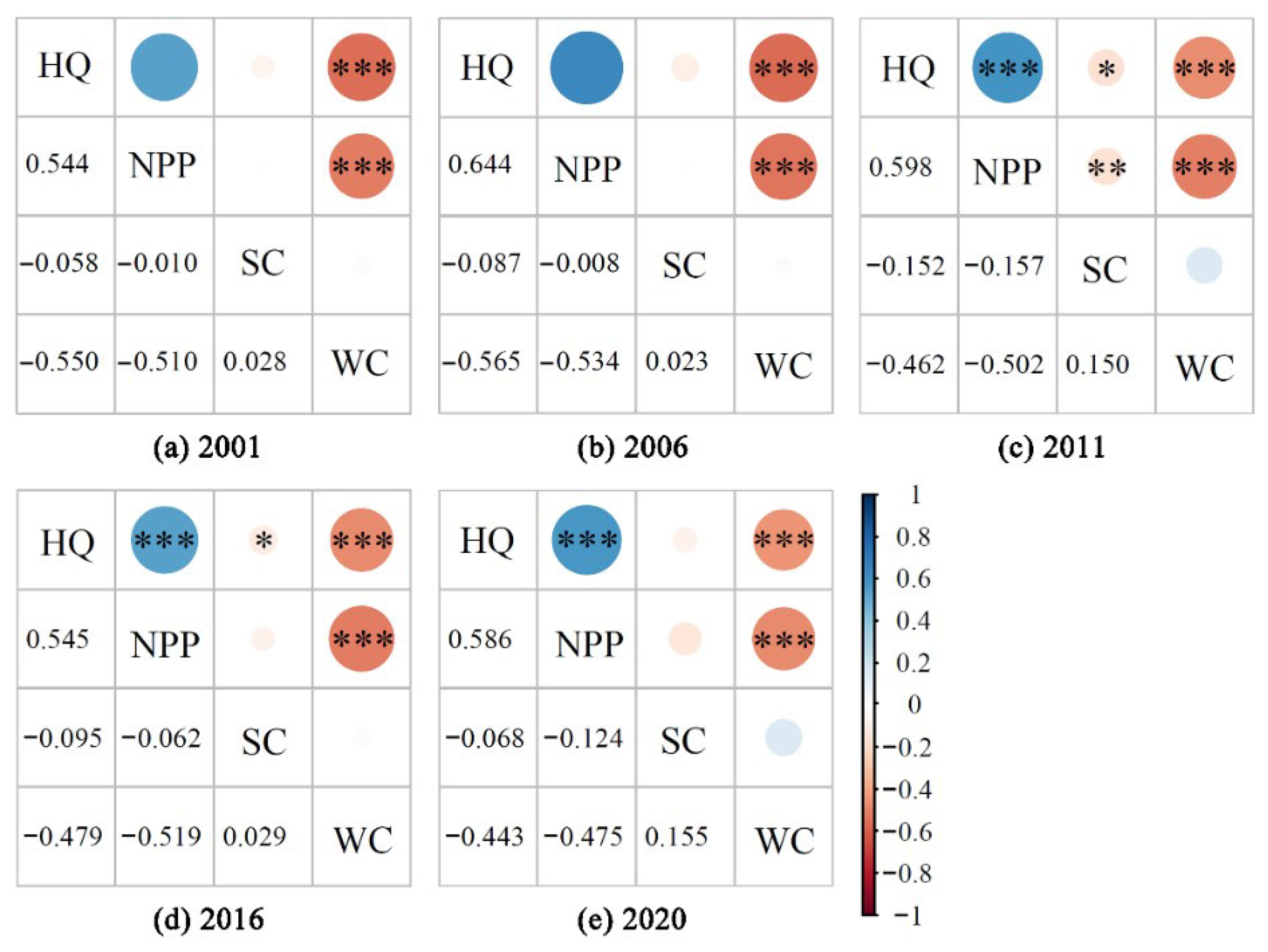
3.2.1. Characteristics of Temporal Changes

Over the past two decades, the correlation coefficient between Habitat Quality (HQ) and Net Primary Productivity (NPP) has been the highest among all ES pairs, with their synergistic relationship showing a steadily increasing trend (Figure 3). In contrast, Soil Conservation (SC) exhibited trade-off relationships with both HQ and NPP, with these trade-offs intensifying over time in a fluctuating manner. SC and Water Conservation (WC) maintained a synergistic relationship; however, the strength of this synergy gradually weakened. Furthermore, trade-off interactions between HQ and WC, as well as between NPP and WC, have shown a declining trend year by year. Notably, the interactions involving SC and the other three services—HQ, WC, and NPP—demonstrated progressively strengthening relationships over time.
Taken together, the evolution of trade-offs and synergies among ESs in Beijing can be largely attributed to the shifting patterns of urban development and ecological governance at different stages. The growing intensity of trade-offs involving SC-related service pairs is mainly driven by the continued expansion of urban construction and the predominance of engineering-based ecological interventions. For example, in projects such as the “Million Mu Afforestation Campaign” and the greening of the urban sub-center, the widespread use of fast-growing, shallow-rooted vegetation has improved NPP but offered limited benefits for soil retention, thereby exacerbating erosion risks and weakening SC. Similarly, the construction of large-scale, rigid hydraulic infrastructure—such as water regulation systems supporting the South-to-North Water Diversion Project—has enhanced WC capacity but disrupted natural surface ecological processes and reduced the available habitat space, further intensifying the functional trade-offs between SC and both HQ and WC.
Conversely, the trade-off intensities between NPP–HQ, NPP–WC, and WC–HQ have exhibited a consistent downward trend, reflecting a gradual shift in ecological construction philosophy from a “greening quantity-oriented” approach toward one emphasizing “ecological function synergy”. Initiatives such as the “Urban Green Heart Forest Park”, the “Yongding River Ecological Corridor”, and “Sponge City” pilot projects have not only expanded urban green coverage but also prioritized ecological connectivity, habitat heterogeneity, and hydrological regulation. The introduction of ecological technologies has enabled improvements in NPP without relying on high water-consuming vegetation, thereby mitigating the conflict between NPP and WC. Meanwhile, the rich structural complexity and biodiversity of ecological green spaces have contributed to enhanced HQ, promoting synergistic transitions in both the NPP–HQ and WC–HQ relationships. These practical developments illustrate that the recent transformation in Beijing’s ecological engineering and spatial governance—toward more integrated and multifunctional systems—is a key mechanism driving the attenuation of trade-offs among ecosystem services.

3.2.2. Characteristics of Spatial Transformations

The trade-offs and synergies among ESs in the Beijing Plain exhibited significant spatial heterogeneity from 2001 to 2020 (Figure 4). NPP-HQ, SC-HQ, and SC-WC predominantly demonstrated synergistic relationships, which displayed clustered spatial patterns and marked spatial variation. The formation of these synergies is closely tied to multiple urban policies and ecological management initiatives.
First, large-scale ecological initiatives such as the Plain Afforestation Program and the “Urban Green Heart” project may have significantly expanded urban green space coverage, thereby potentially offering long-term ecological benefits to the urban core. Notably, the “Million Mu Afforestation and Greening Project” (2012–2015) and the subsequent “Three-Year Action Plan for a New Round of Afforestation” (2018–2020) appear to have been successively implemented in the eastern and southern plain regions, which might have contributed to the establishment of a green infrastructure network composed of urban ring forests, suburban parks, and green corridors. These efforts could have enhanced NPP and may also have contributed to improvements in HQ and SC. Second, the release of the “Beijing Urban Green Space System Plan (2004–2020)” in 2005 seems to have explicitly proposed the development of an urban ecological green space network. By emphasizing the integration of ecological, landscape, and functional objectives, the plan might have laid a spatial foundation for multifunctional coordination within the green space system. Moreover, over the years, Beijing’s promotion of permeable pavements in urban renewal and infrastructure projects is likely to have enhanced surface infiltration and water retention capacities, which may have facilitated synergistic interactions between WC and SC. Conversely, the NPP-WC and WC-HQ pairs were primarily characterized by trade-off relationships, NPP-WC exhibited strong trade-offs in the northern part of the plain, with weaker trade-offs observed in other regions. Meanwhile, WC–HQ trade-offs were mainly distributed outside the core urban area.
In the Beijing Plain, the relationship between Net Primary Productivity (NPP) and Soil Conservation (SC) has shifted from synergy to trade-off, with the emerging trade-off patterns displaying a fragmented spatial distribution centered around the urban core. This spatial fragmentation presents new challenges for regional land-use planning and ecological restoration. On the one hand, land conversion driven by urban expansion has disrupted the balance of ecosystem services, underscoring the urgent need to incorporate ES trade-off regulation mechanisms into spatial planning. Such integration would support more refined spatial governance and promote multifunctional land management strategies. On the other hand, ecological restoration efforts should focus on “ecologically fragile patches” within high-conflict zones, adopting integrated approaches that consider both vegetation quality and soil system functionality. These efforts aim to re-establish synergies between NPP and SC, thereby enhancing the overall stability and service capacity of the regional ecosystem. As shown in Figure 5, the synergy levels of NPP-HQ, NPP-SC, and SC-WC in the plain area exhibited an increasing trend, whereas those of NPP-WC, SC-HQ, and WC-HQ showed a decreasing tendency.

3.3. Identification of the Determinants of Spatial Heterogeneity in ESs

3.3.1. Single-Factor Detection

The magnitude of ecosystem service trade-offs is influenced by variations in temporal and geographical scales. The optimal parameter geographic detector designated the trade-off intensity among ESs as the dependent variable, with possible components considered as independent variables. The methodology integrated many techniques to enhance data discretization, with the indicator discretization procedure elaborated in the accompanying table. Figure 6 illustrates the outcomes of the geographical differentiation study on factors affecting the intensity of trade-off among ESs in the plain area from 2001 to 2020. The land use type was the primary element affecting the trade-off intensity for NPP-HQ, SC-HQ, and WC-HQ, with average explanatory powers of 31.56%, 36.53%, and 29.64%, respectively. The explanatory capacity of the land use type demonstrated a constant upward trend over time, succeeded by factors such as the NDVI, population density, and temperature. For NPP-SC, the NDVI and precipitation had relatively strong impacts. The explanatory power of factors such as the population density, land use type, NDVI, temperature, and precipitation for the NPP-SC trade-off intensity increased significantly, from 1.08%, 0.19%, 0.15%, 3.00%, and 3.87% in 2001 to 13.04%, 19.24%, 25.24%, 12.68%, and 10.92% in 2016. However, these values all experienced sharp declines from 2016 to 2020. For NPP-WC, land use type, temperature, and precipitation were the primary drivers of spatial variation, with average explanatory powers of 7.39%, 7.07%, and 5.17%, respectively, and their influence showed an increasing trend over time. Other factors had relatively weaker impacts. Temperature exerted the greatest significant influence on SC-WC, demonstrating an average explanatory power of 21.70% over 20 years, peaking at 75.77% in 2006. Other influential factors, ranked in descending order, were elevation, land use type, and slope. Land use, temperature, the NDVI, and population density significantly influenced the level of compromise among ESs in the plain area, while elevation, slope, and precipitation exerted comparatively lower effects.

3.3.2. Interaction Detector

Engagement detection assesses whether the influence of a pair of factors on the trade-off intensity is augmented or diminished. In this study, only the top five factor interaction values are listed. As shown in Table 2, most interaction values were significantly higher than the results of single-factor detection, with the dominant interaction effects being non-linear enhancement and bi-factor enhancement. A few interactions exhibited non-linear weakening, indicating that multiple factors interacting together are critical determinants of ecosystem service trade-off intensity. The NDVI remained the principal interaction driver for NPP-HQ, SC-HQ, and WC-HQ throughout the plain area. The trade-off intensity of NPP-HQ was predominantly affected by the interplay between the NDVI, elevation, and precipitation. The relationship between the NDVI and elevation was the principal element influencing the trade-off intensities of SC-HQ and WC-HQ. The relationship between the NDVI and elevation significantly influenced the number of trade-offs in ecological services associated with HQ. For NPP-SC, the interaction of elevation and temperature consistently held a dominant position over the 20-year period, followed by the interaction of elevation and precipitation, highlighting elevation as the most critical factor. For NPP-WC, the primary interaction influencing the trade-off intensity was between temperature and precipitation. Meanwhile, the trade-off intensity of SC-WC was predominantly driven by the interactions of slope with temperature and precipitation.

4. Discussion

4.1. Spatiotemporal Development of ESs in the Plain Area

The North China Plain is a representative region in China with poor ecological conditions, and the Beijing Plain is part of this area. Due to rapid urban expansion and economic growth, the Beijing Plain frequently experiences environmental issues such as severe air pollution (e.g., smog), urban flooding, and inequitable green space distribution. Comprehending the interconnections between ESs and investigating their influencing aspects are crucial for the efficient management of habitats and human settlements in the plain area. This research applied numerous methods, including correlation analysis, GWR, and GeoDetector, to ascertain the spatiotemporal interpersonal connections among ESs and their dominant motivating factors.
The findings revealed that the trade-offs and synergies of ESs in the plain area vary across temporal and spatial scales. For instance, Net Primary Productivity (NPP) and Soil Conservation (SC) demonstrated a temporal trade-off relationship, but spatially, it was synergistic during 2001–2006 and trade-off-oriented during 2011–2020. The trade-offs between NPP and SC are due to the spatial distribution of SC, informed by soil data at the grid size. Higher vegetation carbon sequestration (NPP) hinders the maintenance of soil organic matter, leading to a compromise connection between the two functions. Spatially, a long-term dynamic analysis of ESs based on grid-scale changes showed that prior to 2006, the richness of plant communities in the plain area facilitated an increasing trend in SC. Nonetheless, due to urban expansion and ecological pollution, soil degradation intensified, leading to a trade-off where enhancements in NPP were associated with a decrease in SC.

4.2. Determinants of Spatial Heterogeneity of ESs

This study examined the driving factors of ESs trade-offs in the plain area utilizing GeoDetector. The findings demonstrate that natural environmental factors exert a more significant impact on the intensity of trade-offs among ESs than human activity factors. The principal causes of trade-offs across ESs emerge not from isolated elements but from the interactions between two services or common influencing factors, consistent with prior research findings [62]. Moreover, the combined effects of different factors are not limited to opposite changes between two services but also manifest as unequal rates of change during synergistic processes. For instance, while NPP-WC demonstrates a trade-off relationship, increased precipitation significantly enhances the water conservation capacity while also playing a key explanatory role in the NPP-WC trade-off intensity. Land use type emerged as the primary driver for Net Primary Productivity (NPP), Habitat Quality (HQ) and their interactions with other ESs, consistent with previous studies [63,64]. The strength of NPP is largely determined by vegetation coverage. In this study, the impacts of different types of land use change on ESs trade-offs were found to vary significantly. Among these, the conversion of cropland to construction land had the most pronounced effect on ESs trade-offs. This transformation typically leads to increased habitat fragmentation, soil structure degradation, and a reduction in the hydrological regulation capacity, thereby markedly intensifying the trade-offs among NPP–HQ, SC–HQ, and WC–HQ. Additionally, the conversion of forest land to construction land or cropland also severely degrades habitat quality and weakens both soil retention and water conservation capacities, disrupting existing synergistic relationships among services. These effects are particularly evident in the piedmont areas of northern Beijing. In contrast, land use changes from cropland to forest land or ecological green space help to mitigate the trade-offs between services by enhancing vegetation coverage and habitat heterogeneity, thus reinforcing the synergies among NPP, HQ, and SC. Furthermore, the conversion of grassland or bare land to construction land significantly affects the sensitivity of SC–HQ and WC–HQ interactions, often resulting in increased surface runoff and broader ecosystem degradation.
However, human activities, such as the outward expansion of urban construction land, have exacerbated trade-offs among NPP-SC, SC-HQ, and NPP-WC, affecting ecosystems and degrading their regulatory functions, such as habitat loss and soil erosion. HQ depends on species abundance and biodiversity, and changes in land use contribute to the trade-offs between SC-HQ and WC-HQ. NPP-SC, NPP-WC, and SC-WC are significantly influenced by temperature and precipitation. High-intensity trade-off zones are mostly situated on the outskirts of the central suburban district, with a scattered distribution pattern. Peripheral areas, with less construction land, support higher NPP but contribute less to soil and water conservation. Due to the plain area’s unique geomorphology, extensive farmland and over-cultivation have directly exacerbated soil erosion, intensifying trade-offs among NPP-SC, NPP-WC, and SC-WC. Temperature plays a critical role in regulating soil moisture balance and vegetation stability, as it influences soil evaporation rates, plant growth cycles, and soil biological activity. When combined with precipitation, these factors jointly determine the balance between water supply and demand. For instance, 2006 was a typical high-temperature year, during which summer rainfall was intense and concentrated, with frequent extreme precipitation events. Due to limited surface infiltration during short-duration downpours, the surface runoff intensified, resulting in severe erosion and a sharp imbalance in the SC–WC relationship, with an explanatory power reaching 75.77%.

4.3. Management and Policy Interventions for ESs

Given the significant trade-offs among multiple ecosystem services (ESs), the scientific identification of dominant driving factors and spatial optimization of service structures are critical to achieving synergistic enhancement. This study reveals that the NDVI, slope, and elevation are the primary factors influencing the relationships between NPP–HQ, SC–HQ, and WC–HQ, while elevation, temperature, and land use significantly regulate trade-offs such as NPP–SC, NPP–WC, and WC–HQ. Accordingly, policy interventions aimed at coordinating ES development should prioritize the following strategies: First, land-use policies guided by spatial optimization should be prioritized. In particular, to address the fragmentation of cropland in the plain area, it is essential to consolidate scattered farmland and construct ecological buffer zones to enhance landscape connectivity. Simultaneously, tree species with varied canopy heights and root structures should be planted based on local elevation and slope conditions, thereby improving slope stability and the water retention capacity—ultimately reducing trade-offs between NPP–SC and WC–HQ at the source. Second, greater emphasis should be placed on optimizing the ecological configuration of peri-urban areas. Since trade-offs in these transitional zones are generally more intense than in urban cores, it is advisable to prioritize the restoration and reconstruction of semi-natural habitats in such regions. Enhancing the diversity and connectivity of green spaces, while increasing the extent of ecological detention zones and buffer strips, can mitigate habitat fragmentation, improve HQ, regulate stormwater runoff, and reduce conflicts between WC and SC. This, in turn, can strengthen the ecosystem’s adaptive capacity in flood-prone areas [65]. Third, it is essential to incorporate multi-factor interaction mechanisms into spatial governance evaluation frameworks. Future ES management should move beyond optimizing individual services to account for the complex interactions among climatic zones, vegetation types, and landform features. Constructing trade-off response models within a climate–terrain–vegetation tridimensional spatial framework will support the development of differentiated ecological zoning strategies, offering more targeted policy pathways at the regional scale. Finally, the development of dynamic ecological monitoring and feedback evaluation mechanisms is needed to ensure that policy interventions can respond rapidly to shifts in ES trade-offs. By leveraging remote sensing data, dynamic NDVI indices, and multi-source geospatial monitoring systems, it is possible to assess post-implementation changes in ES relationships in a timely manner. This ensures that interventions remain aligned with synergistic goals and prevents local service enhancement from leading to systemic imbalance.
In summary, coordination among ecosystem services is not a static equilibrium but a dynamic adjustment process driven by complex natural and anthropogenic factors. Therefore, policy design should adopt a multidimensional approach encompassing spatial structure optimization, region-specific governance, multi-driver coupling mechanisms, and real-time adaptive feedback. Such strategies are essential to achieve synergistic service enhancement, spatially balanced development, and long-term ecosystem resilience.

4.4. Uncertainty Analysis

This research investigated the determinants affecting the complex interconnections in the midst of several ESs. However, due to methodology and data constraints, the selection of influencing factors leaned heavily toward natural environmental indicators, with an insufficient consideration of human activity factors and urban morphology variables. To address this limitation, future studies should incorporate a broader range of anthropogenic indicators—such as the proportion of impervious surfaces and nighttime light intensity—to more accurately capture the effect of the disturbance intensity of urbanization on ESs and uncover the corresponding ecological response mechanisms across varying spatial scales. In parallel, advancing the quantitative depiction of urban form and spatial structure through metrics such as urban boundary compactness and green patch connectivity can help elucidate the spatial coupling between urban expansion patterns and ES trade-offs. Furthermore, the inclusion of institutional variables—such as the implementation status of ecological protection policies and the intensity of ecological engineering (e.g., ecological redlines and sub-center development zones)—into the analytical framework would enable more robust assessments of policy effectiveness in mediating ES relationships. On the data front, integrating high-resolution remote sensing products and dynamic meteorological variables (e.g., land surface temperature) would significantly enhance the accuracy of monitoring spatiotemporal changes in ecosystem services. Given the potential scale dependence of ES trade-offs [66], multi-scale spatial analytical approaches should be applied to systematically compare the synergy and trade-off patterns across neighborhood, district, and citywide levels. This would aid in identifying spatial thresholds and ecologically sensitive areas, thereby providing more targeted and scientifically grounded support for fine-scale regulation and zoned ecosystem management.

5. Conclusions

This study employed the InVEST model to quantitatively evaluate the spatiotemporal attributes of four ESs (Net Primary Productivity, Soil Conservation, Water Conservation and Habitat Quality) in the Beijing Plain area from 2001 to 2020. Correlation analysis and GWR were utilized to assess the trade-offs and synergies across ESs, while the optimal parameter geographic detector identified the principal influencing factors and their combinations that drive trade-off intensity. The principal results are as follows.
From 2001 to 2020, HQ and SC exhibited a declining trend, while NPP and WC increased. The trade-off intensity of NPP-SC, NPP-WC, and WC-HQ escalated gradually, while the trade-off intensity of NPP-HQ, SC-HQ, and SC-WC diminished.
Overall, NPP-HQ, SC-HQ, and SC-WC exhibited synergistic relationships. NPP-SC showed a coexistence of both trade-off and synergy, while NPP-WC and WC-HQ demonstrated trade-off relationships. The regions exhibiting significant synergy in NPP-HQ, SC-HQ, and SC-WC were predominantly located in the central metropolitan area, with sporadic synergies in the southeast and northwest. NPP-SC had an irregular and markedly heterogeneous regional distribution pattern. The spatiotemporal distribution of NPP-WC and WC-HQ was highly similar, both showing strong synergy. NPP-WC exhibited a strong trade-off in the northern plain area, while other areas showed weaker trade-offs. The trade-off relationship between WC-HQ was stronger outside the central urban area. Over time, the synergy between NPP-HQ increased annually. NPP-SC showed a fluctuating pattern between trade-off and synergy, while the trade-off between NPP-WC and WC-HQ exhibited slight annual fluctuations but showed an increasing trend. The synergy between SC-HQ and SC-WC increased each year.
The kind of land use was the primary element affecting the trade-off intensity of NPP-HQ, SC-HQ, and WC-HQ. The NDVI and precipitation had a stronger influence on NPP-SC, while land use type, temperature, and precipitation were the main driving factors behind the spatial differentiation of NPP-WC. Temperature had the most significant effect on SC-WC. The intensity of trade-offs between ESs is not influenced by a single factor; rather, it is driven by the interactions or shared influencing factors between the two services. The trade-offs among ESs exhibited high spatial heterogeneity.

Author Contributions

Conceptualization, L.B.; methodology, L.B.; software, L.B.; validation, L.B. and Y.L.; formal analysis, L.B.; resources, L.B.; data curation, L.B.; writing—original draft preparation, L.B.; writing—review and editing, L.B. and Y.L.; visualization, L.B.; supervision, Y.L.; funding acquisition, Y.L. All authors have read and agreed to the published version of the manuscript.

Funding

This research was funded by the National Natural Science Funds of China, grant number 52078040 and Beijing Forestry University Professional Degree Graduate Course Case Library Construction Project, grant number KCAL24013.

Data Availability Statement

DEM data for Beijing were sourced from the Geospatial Data Cloud at http://www.gscloud.cn/ (accessed on 24 December 2023). NDVI data for the China region were derived from the MOD13Q1 NDVI dataset supplied by NASA’s Earth Data Center at https://earthdata.nasa.gov/ (accessed on 24 December 2023). Data on the monthly precipitation, mean monthly temperature, sun-shine length, and total monthly solar radiation were obtained from the National Earth System Science Data Center at http://www.geodata.cn (accessed on 24 December 2023). Data for China’s potential evapotranspiration were sourced from the National Tibetan Plateau Scientific Data Center at http://www.ncdc.ac.cn (accessed on 24 December 2023). Administrative boundary data were sourced from the Resource and Environment Science and Data Center of the Chinese Academy of Sciences at https://www.resdc.cn (accessed on 24 December 2023). Population density statistics were sourced from WorldPop at https://www.worldpop.org/ (accessed on 24 December 2023).

Conflicts of Interest

The authors declare no conflict of interest.

References

  1. Millennium Ecosystem Assessment. Ecosystems and Human Well-Being; Island Press: Washington, DC, USA, 2005; Volume 5. [Google Scholar]
  2. Costanza, R.; d’Arge, R.; De Groot, R.; Farber, S.; Grasso, M.; Hannon, B.; Limburg, K.; Naeem, S.; O’neill, R.V.; Paruelo, J.J. The Value of the World’s Ecosystem Services and Natural Capital. Nature 1997, 387, 253–260. [Google Scholar] [CrossRef]
  3. Daily, G.C. Nature’s Services: Societal Dependence on Natural Ecosystems; Island Press: Washington, DC, USA, 1997. [Google Scholar]
  4. Bolund, P.; Hunhammar, S. Ecosystem Services in Urban Areas. J. Ecol. Econ. 1999, 29, 293–301. [Google Scholar] [CrossRef]
  5. Feng, Z.; Jin, X.; Chen, T.; Wu, J. Understanding Trade-Offs and Synergies of Ecosystem Services to Support the Decision-Making in the Beijing–Tianjin–Hebei Region. Land Use Policy 2021, 106, 105446. [Google Scholar] [CrossRef]
  6. Venalainen, A.; Lehtonen, I.; Laapas, M.; Ruosteenoja, K.; Tikkanen, O.P.; Viiri, H.; Ikonen, V.P.; Peltola, H. Climate Change Induces Multiple Risks to Boreal Forests and Forestry in Finland: A Literature Review. Glob. Change Biol. 2020, 26, 4178–4196. [Google Scholar] [CrossRef] [PubMed]
  7. Martens, C.; Hickler, T.; Davis-Reddy, C.; Engelbrecht, F.; Higgins, S.I.; von Maltitz, G.P.; Midgley, G.F.; Pfeiffer, M.; Scheiter, S. Large Uncertainties in Future Biome Changes in Africa Call for Flexible Climate Adaptation Strategies. Glob. Change Biol. 2021, 27, 340–358. [Google Scholar] [CrossRef]
  8. Ajjur, S.B.; Al-Ghamdi, S.G. Exploring Urban Growth-Climate Change-Flood Risk Nexus in Fast Growing Cities. Sci. Rep. 2022, 12, 12265. [Google Scholar] [CrossRef]
  9. Chen, G.; Peng, Q.; Fan, Q.; Lin, W.; Su, K. Spatial-Temporal Variation and Driving Forces of Carbon Storage at the County Scale in China Based on a Gray Multi-Objective Optimization-Patch-Level Land Use Simulation-Integrated Valuation of Ecosystem Services and Tradeoffs-Optimal Parameter-Based Geographical Detector Model: Taking the Daiyun Mountain’s Rim as an Example. Land 2024, 14, 14. [Google Scholar] [CrossRef]
  10. Magle, S.B.; Fidino, M.; Sander, H.A.; Rohnke, A.T.; Larson, K.L.; Gallo, T.; Kay, C.A.M.; Lehrer, E.W.; Murray, M.H.; Adalsteinsson, S.A.; et al. Wealth and Urbanization Shape Medium and Large Terrestrial Mammal Communities. Glob. Change Biol. 2021, 27, 5446–5459. [Google Scholar] [CrossRef]
  11. Kotze, D.J.; Ghosh, S.; Hui, N.; Jumpponen, A.; Lee, B.P.Y.; Lu, C.; Lum, S.; Pouyat, R.; Szlavecz, K.; Wardle, D.A.; et al. Urbanization Minimizes the Effects of Plant Traits on Soil Provisioned Ecosystem Services across Climatic Regions. Glob. Change Biol. 2021, 27, 4139–4153. [Google Scholar] [CrossRef]
  12. Wang, K.; Gao, J.; Liu, C.; Zhang, Y.; Wang, C. Understanding the Effects of Socio-Ecological Factors on Trade-Offs and Synergies among Ecosystem Services to Support Urban Sustainable Management: A Case Study of Beijing, China. Sustain. Cities Soc. 2023, 100, 105024. [Google Scholar] [CrossRef]
  13. Ruhl, J.B.; Salzman, J.; Arnold, C.A.; Craig, R.; Hirokawa, K.; Olander, L.; Palmer, M.; Ricketts, T.H. Connecting Ecosystem Services Science and Policy in the Field. Front. Ecol. Environ. 2021, 19, 519–525. [Google Scholar] [CrossRef]
  14. Zhang, Z.; Liu, Y.; Wang, Y.; Liu, Y.; Zhang, Y.; Zhang, Y. What Factors Affect the Synergy and Tradeoff between Ecosystem Services, and How, from a Geospatial Perspective? J. Clean. Prod. 2020, 257, 120454. [Google Scholar] [CrossRef]
  15. Jiang, W.; Wu, T.; Fu, B. The Value of Ecosystem Services in China: A Systematic Review for Twenty Years. Ecosyst. Serv. 2021, 52, 101365. [Google Scholar] [CrossRef]
  16. Yang, M.; Zhao, X.; Wu, P.; Hu, P.; Gao, X. Quantification and Spatially Explicit Driving Forces of the Incoordination between Ecosystem Service Supply and Social Demand at a Regional Scale. Ecol. Indic. 2022, 137, 108764. [Google Scholar] [CrossRef]
  17. Lee, H.; Lautenbach, S. A Quantitative Review of Relationships between Ecosystem Services. Ecol. Indic. 2016, 66, 340–351. [Google Scholar] [CrossRef]
  18. Assubayeva, A.; Marco, J. Methodological Approaches on Synergies and Trade-Offs within the 2030 Agenda. iScience 2024, 27, 111100. [Google Scholar] [CrossRef]
  19. Li, G.; Jiang, C.; Gao, Y.; Du, J. Natural Driving Mechanism and Trade-Off and Synergy Analysis of the Spatiotemporal Dynamics of Multiple Typical Ecosystem Services in Northeast Qinghai-Tibet Plateau. J. Clean. Prod. 2022, 374, 134075. [Google Scholar] [CrossRef]
  20. Yang, M.; Gao, X.; Zhao, X.; Wu, P. Scale Effect and Spatially Explicit Drivers of Interactions between Ecosystem Services—A Case Study from the Loess Plateau. Sci. Total Environ. 2021, 785, 147389. [Google Scholar] [CrossRef]
  21. Qiao, X.; Gu, Y.; Zou, C.; Xu, D.; Wang, L.; Ye, X.; Yang, Y.; Huang, X. Temporal Variation and Spatial Scale Dependency of the Trade-Offs and Synergies among Multiple Ecosystem Services in the Taihu Lake Basin of China. Sci. Total Environ. 2019, 651, 218–229. [Google Scholar] [CrossRef]
  22. Mach, M.E.; Martone, R.G.; Chan, K.M.A. Human Impacts and Ecosystem Services: Insufficient Research for Trade-Off Evaluation. Ecosyst. Serv. 2015, 16, 112–120. [Google Scholar] [CrossRef]
  23. Li, S.; Zhou, Y.; Yue, D.; Guo, Z.; Li, Z. Scenario Simulation of Ecosystem Services Based on Land Use/Land Cover Change in the Bailong River Basin, in China. Land 2024, 14, 25. [Google Scholar] [CrossRef]
  24. Booi, S.; Mishi, S.; Andersen, O. Ecosystem Services: A Systematic Review of Provisioning and Cultural Ecosystem Services in Estuaries. Sustainability 2022, 14, 7252. [Google Scholar] [CrossRef]
  25. Wang, J.; Peng, J.; Zhao, M.; Liu, Y.; Chen, Y. Significant Trade-Off for the Impact of Grain-for-Green Programme on Ecosystem Services in North-Western Yunnan, China. Sci. Total Environ. 2017, 574, 57–64. [Google Scholar] [CrossRef]
  26. Schirpke, U.; Ghermandi, A.; Sinclair, M.; Van Berkel, D.; Fox, N.; Vargas, L.; Willemen, L. Emerging Technologies for Assessing Ecosystem Services: A Synthesis of Opportunities and Challenges. Ecosyst. Serv. 2023, 63, 101558. [Google Scholar] [CrossRef]
  27. Zhang, J.; Wang, Y.; Sun, J.; Zhang, Y.; Wang, D.; Chen, J.; Liang, E. Trade-Offs and Synergies of Ecosystem Services and Their Threshold Effects in the Largest Tableland of the Loess Plateau. Glob. Ecol. Conserv. 2023, 48, e02706. [Google Scholar] [CrossRef]
  28. Geng, W.; Li, Y.; Zhang, P.; Yang, D.; Jing, W.; Rong, T. Analyzing Spatio-Temporal Changes and Trade-Offs/Synergies among Ecosystem Services in the Yellow River Basin, China. Ecol. Indic. 2022, 138, 108825. [Google Scholar] [CrossRef]
  29. Jia, Y.; Tang, X.; Liu, W. Spatial–Temporal Evolution and Correlation Analysis of Ecosystem Service Value and Landscape Ecological Risk in Wuhu City. Sustainability 2020, 12, 2803. [Google Scholar] [CrossRef]
  30. Li, B.; Wang, W. Trade-Offs and Synergies in Ecosystem Services for the Yinchuan Basin in China. Ecol. Indic. 2018, 84, 837–846. [Google Scholar] [CrossRef]
  31. Feng, Q.; Zhao, W.; Fu, B.; Ding, J.; Wang, S. Ecosystem Service Trade-Offs and Their Influencing Factors: A Case Study in the Loess Plateau of China. Sci. Total Environ. 2017, 607, 1250–1263. [Google Scholar] [CrossRef]
  32. Li, Y.; Luo, H. Trade-Off/Synergistic Changes in Ecosystem Services and Geographical Detection of Its Driving Factors in Typical Karst Areas in Southern China. Ecol. Indic. 2023, 154, 110811. [Google Scholar] [CrossRef]
  33. Zhang, X.; Yin, Q.; Zheng, Z.; Sun, S.; Huang, J. Dynamic Changes and Key Drivers of Ecosystem Service Values in Populous Zones on the Tibetan Plateau: A 35-Year Analysis. Ecol. Indic. 2024, 167, 112620. [Google Scholar] [CrossRef]
  34. Li, H.; Chen, J.; Ling, M.; Chen, Z.; Lan, Y.; Huang, Q.; Li, X.; You, H.; Wang, F.; Han, X.; et al. A Framework for Dynamic Assessment of Soil Erosion and Detection of Driving Factors in Alpine Grassland Ecosystems Using the Rusle-Invest (Sdr) Model and Geodetector: A Case Study of the Source Region of the Yellow River. Ecol. Inform. 2025, 85, 102928. [Google Scholar] [CrossRef]
  35. Song, Y.; Wang, J.; Ge, Y.; Xu, C.J. An Optimal Parameters-Based Geographical Detector Model Enhances Geographic Characteristics of Explanatory Variables for Spatial Heterogeneity Analysis: Cases with Different Types of Spatial Data. GISci. Remote Sens. 2020, 57, 593–610. [Google Scholar] [CrossRef]
  36. Carnegie Institution of Washington; Willis, B.; Blackwelder, E.; Sargent, R.H.; Hirth, F.; Walcott, C.D.; Weller, S.; Girty, G.H. Research in China …: Systematic Geology, by Bailey Willis; Carnegie Institution of Washington: Washington, DC, USA, 1907. [Google Scholar]
  37. Ali, K.; Shah, J.A.; Ullah, S.; Raza, S.T. Quantifying Sustainable Urbanization by Predictive Modeling for Better Agricultural Management: A Case Study in the South Asiatic Region. Heliyon 2025, 11, e40978. [Google Scholar] [CrossRef]
  38. Xu, X.; Ma, J.; Sho, K.; Seta, F. Urban Growth Divides: The Inevitable Structure of Shrinking Cities in Urbanization Evolution. Cities 2025, 158, 105638. [Google Scholar] [CrossRef]
  39. Zhao, Y.; Wang, L.; Lei, X.; Wang, B.; Cui, J.; Xu, Y.; Chen, Y.; Sui, P. Reducing Carbon Footprint without Compromising Grain Security through Relaxing Cropping Rotation System in the North China Plain. J. Clean. Prod. 2021, 318, 128465. [Google Scholar] [CrossRef]
  40. Ma, Y.; Yang, J. A Review of Methods for Quantifying Urban Ecosystem Services. Landsc. Urban Plan. 2025, 253, 105215. [Google Scholar] [CrossRef]
  41. Sun, X.; Lu, Z.; Feng Li Crittenden, J.C. Analyzing Spatio-Temporal Changes and Trade-Offs to Support the Supply of Multiple Ecosystem Services in Beijing, China. Ecol. Indic. 2018, 94, 117–129. [Google Scholar] [CrossRef]
  42. van Oort, P.A.J.; Wang, G.; Vos, J.; Meinke, H.; Li, B.G.; Huang, J.K.; van der Werf, W. Towards Groundwater Neutral Cropping Systems in the Alluvial Fans of the North China Plain. Agric. Water Manag. 2016, 165, 131–140. [Google Scholar] [CrossRef]
  43. Zhao, Z.; Qin, X.; Zang, H.; Chen, C.; Zhang, Y.; Wang, Z. Value of Groundwater Used for Producing Extra Grain in North China Plain. Field Crops Res. 2017, 210, 47–51. [Google Scholar] [CrossRef]
  44. Evans, D.L.; Falagán, N.; Hardman, C.A.; Kourmpetli, S.; Liu, L.; Mead, B.R.; Davies, J.A.C. Ecosystem Service Delivery by Urban Agriculture and Green Infrastructure—A Systematic Review. Ecosyst. Serv. 2022, 54, 101405. [Google Scholar] [CrossRef]
  45. Pinto, L.V.; Inácio, M.; Ferreira, C.S.S.; Ferreira, A.D.; Pereira, P. Ecosystem Services and Well-Being Dimensions Related to Urban Green Spaces—A Systematic Review. Sustain. Cities Soc. 2022, 85, 104072. [Google Scholar] [CrossRef]
  46. Yang, J.; Huang, X. The 30 M Annual Land Cover Dataset and Its Dynamics in China from 1990 to 2019. Earth Syst. Sci. Data 2021, 13, 3907–3925. [Google Scholar] [CrossRef]
  47. Potter, C.S.; Randerson, J.T.; Field, C.B.; Matson, P.A.; Vitousek, P.M.; Mooney, H.A.; Klooster, S.A. Terrestrial Ecosystem Production: A Process Model Based on Global Satellite and Surface Data. Glob. Biogeochem. Cycles 1993, 7, 811–841. [Google Scholar] [CrossRef]
  48. Zhu, W.; Pan, Y.; Zhang, J. Estimation of Net Primary Productivity of Chinese Terrestrial Vegetation Based on Remotesensing. Chin. J. Plant Ecol. 2007, 3, 413–424. [Google Scholar]
  49. Renard, K.G.; Foster, G.R.; Weesies, G.A.; Mccool, D.K.; Yoder, D.C. Predicting Soil Erosion by Water: A Guide to Conservation Planning with the Revised Universal Soil Loss Equation (Rusle); US Department of Agriculture, Agricultural Research Service: Washington, DC, USA, 1997.
  50. Wischmeier, W.H.; Smith, D.D. Predicting Rainfall Erosion Losses: A Guide to Conservation Planning; Department of Agriculture, Science and Education Administration: Washington, DC, USA, 1978.
  51. United Nations Environment Programme. Globio: Global Methodology for Mapping Human Impacts on the Biosphere: The Arctic 2050 Scenario and Global Application; UNEP-DEWA: Nairobi, Kenya, 2001. [Google Scholar]
  52. Lyu, R.; Clarke, K.C.; Zhang, J.; Feng, J.; Jia, X.; Li, J. Spatial Correlations among Ecosystem Services and Their Socio-Ecological Driving Factors: A Case Study in the City Belt Along the Yellow River in Ningxia, China. Appl. Geogr. 2019, 108, 64–73. [Google Scholar] [CrossRef]
  53. Simeon, M.; Wana, D. Synergies and Trade-Offs among Key Ecosystem Services in Maze National Park and Its Environs, Southwestern Ethiopia. Glob. Ecol. Conserv. 2025, 57, e03398. [Google Scholar] [CrossRef]
  54. Wu, L.; Sun, C.; Fan, F. Multi-Criteria Framework for Identifying the Trade-Offs and Synergies Relationship of Ecosystem Services Based on Ecosystem Services Bundles. Ecol. Indic. 2022, 144, 109453. [Google Scholar] [CrossRef]
  55. Dou, H.; Li, X.; Li, S.; Dang, D.; Li, X.; Lyu, X.; Li, M.; Liu, S. Mapping Ecosystem Services Bundles for Analyzing Spatial Trade-Offs in Inner Mongolia, China. J. Clean. Prod. 2020, 256, 120444. [Google Scholar] [CrossRef]
  56. Brunsdon, C.; Fotheringham, A.S.; Charlton, M.E. Geographically Weighted Regression: A Method for Exploring Spatial Nonstationarity. Geogr. Anal. 1996, 28, 281–298. [Google Scholar] [CrossRef]
  57. Wang, J.F.; Xu, C.D. Geodetector: Principle and Prospective. Acta Geogr. Sin. 2017, 72, 116–134. [Google Scholar]
  58. Chen, S.; Liu, X.; Yang, L.; Zhu, Z. Variations in Ecosystem Service Value and Its Driving Factors in the Nanjing Metropolitan Area of China. Forests 2023, 14, 113. [Google Scholar] [CrossRef]
  59. Yang, Z.; Wang, H.; Chen, B. Assessment of Urban Waterlogging-Induced Road Traffic Safety Risk and Identification of Its Driving Factors: A Case Study of Beijing. Transp. Res. Part A Policy Pract. 2024, 183, 104080. [Google Scholar] [CrossRef]
  60. Huang, X.; Wang, Y.; Wang, X.; Chen, J.; Ma, J.; Liang, E.; Wang, X. Exploring the Natural-Socioeconomic Driving and Response Mechanisms of Ecosystem Services Interactions to Optimize Ecosystem Management: A Case Study in the Yarlung Zangbo River Basin. Sci. Total Environ. 2024, 957, 177842. [Google Scholar] [CrossRef]
  61. Zhang, H.; Liu, S. Exploring the Spatial–Temporal Patterns of Urban Ecosystem Service Relationships and Their Driving Mechanisms: A Case Study of Wuhu City, China. Ecol. Indic. 2024, 167, 112726. [Google Scholar] [CrossRef]
  62. Gong, L.; Wang, L.; Hu, R.; Lu, X.; Sun, Y.; Zhang, S.; Zhang, G.; Tan, B. Identification of Unique Ecosystem Service Bundles in Farmland—A Case Study in the Huang-Huai-Hai Plain of China. J. Environ. Manag. 2024, 370, 122516. [Google Scholar] [CrossRef] [PubMed]
  63. Wang, W.; Deng, X.; Wang, Y.; Peng, L.; Yu, Z. Impacts of Infrastructure Construction on Ecosystem Services in New-Type Urbanization Area of North China Plain. Resour. Conserv. Recycl. 2022, 185, 106376. [Google Scholar] [CrossRef]
  64. Cao, T.; Yi, Y.; Liu, H.; Xu, Q.; Yang, Z. The Relationship between Ecosystem Service Supply and Demand in Plain Areas Undergoing Urbanization: A Case Study of China’s Baiyangdian Basin. J. Environ. Manag. 2021, 289, 112492. [Google Scholar] [CrossRef] [PubMed]
  65. Cheng, J.; Richter, A.; Cong, W.-F.; Xu, Z.; Liang, Z.; Zhang, C.; Zhang, F.; van der Werf, W.; Groot, J.C.J. Stakeholder Perspectives on Ecosystem Services in Agricultural Landscapes: A Case Study in the North China Plain. Agric. Syst. 2025, 223, 104187. [Google Scholar] [CrossRef]
  66. Li, Y.; Geng, H.; Luo, G.; Wu, L.; Wang, J.; Wu, Q. Multiscale Characteristics of Ecosystem Service Value Trade-Offs/Synergies and Their Response to Landscape Pattern Evolution in a Typical Karst Basin in Southern China. Ecol. Inform. 2024, 81, 102584. [Google Scholar] [CrossRef]
Figure 1. Geographical location map of the research area.
Land 14 00949 g001
Figure 2. Spatiotemporal distribution of ESs.
Land 14 00949 g002
Figure 3. Correlations of ESs. ** Significant correlation at p < 0.01 (two-tailed). * Significant correlation at p < 0.05 (two-tailed). *** Significant correlation at p < 0.001 (two-tailed).
Land 14 00949 g003
Figure 4. Spatial trade-offs and intensity of synergies in ESs.
Land 14 00949 g004
Figure 5. Modification of ES synergy intensity in the plain area (2001–2020).
Land 14 00949 g005
Figure 6. Impact of determinants on spatial variability of ESs in the plain area. X1, Population Density; X2, Land Use Type; X3, NDVI; X4, Elevation; X5, Slope; X6, Temperature; X7, Precipitation.
Land 14 00949 g006
Table 1. Influencing factors selected in this study.
IndicatorFactor DescriptionClassification
Population densityReflecting the population distribution within a 1-square-kilometer grid.natural breakpoint: 7
Land use typeCropland, Forest, Shrub, Grassland, Water, Sonw/Ice, Barren, Impervious, Wetland.-
NDVIVegetation Coverageequal interval: 7
ElevationDerived from DEM (Digital Elevation Model) data.natural breakpoint: 7
SlopeDerived using analysis performed in ArcGIS 10.8.geometric interval: 7
Annual average temperatureDerived from daily temperature data at surrounding stations, interpolated using the ANUSPLIN model.natural breakpoint: 7
Annual precipitationDerived from daily precipitation data at surrounding stations, interpolated using the ANUSPLIN model.natural breakpoint: 7
Table 2. Interaction detection results for ESs trade-off intensity in the plain area.
Ecosystem ServiceYearDominant Interaction 1Dominant Interaction 2Dominant Interaction 3Dominant Interaction 4Dominant Interaction 5
NPP-HQ2001X3∩X4: 0.316NEX3∩X7: 0.310DEX3∩X6: 0.296DEX1∩X3: 0.281DEX6∩X7: 0.274NE
2006X3∩X7: 0.211NEX3∩X4: 0.193NEX2∩X7: 0.190NWX1∩X2: 0.187NWX1∩X3: 0.187DE
2011X3∩X4: 0.271NEX1∩X3: 0.261DEX3∩X6: 0.261DEX3∩X7: 0.246NEX3∩X5: 0.238NE
2016X1∩X6: 0.311DEX1∩X3: 0.276DEX1∩X4: 0.273NEX3∩X6: 0.272DEX4∩X6: 0.266NE
2020X1∩X6: 0.349DEX1VX4: 0.321NEX1∩X3: 0.299DEX1∩X2: 0.295NWX4∩X6: 0.284NE
NPP-SC2001X6∩X7: 0.090NEX4∩X7: 0.0830NEX4∩X6: 0.0610NEX1∩X4: 0.053NEX1∩X6: 0.051NE
2006X4∩X6: 0.087NEX4∩X7: 0.082NEX3∩X7: 0.074NEX3∩X6: 0.071NEX6∩X7: 0.069NE
2011X4∩X6: 0.116NEX4∩X7: 0.116NEX6∩X7: 0.105NEX3∩X7: 0.093NEX1∩X7: 0.069NE
2016X4∩X6: 0.087NEX6∩X7: 0.065NEX4∩X7: 0.064NEX1∩X4: 0.059NEX1∩X6: 0.056NE
2020X4∩X6: 0.067NEX4∩X7:0.042NEX6∩X7: 0.035DEX5∩X6: 0.034NEX3∩X6: 0.031NE
NPP-WC2001X6∩X7: 0.119NEX4∩X6: 0.094NEX1∩X6: 0.085NEX4∩X7: 0.084NEX1∩X4: 0.081NE
2006X6∩X7: 0.096NEX4∩X6: 0.090NEX3∩X6: 0.085NEX1∩X7: 0.083NEX1∩X6: 0.082NE
2011X6∩X7: 0.116NEX4∩X6: 0.102NEX3∩X6: 0.099NEX1∩X6: 0.099NEX5∩X6: 0.096NE
2016X1∩X7: 0.188NEX6∩X7: 0.185DEX4∩X7: 0.166NEX2∩X7: 0.160DEX3∩X7: 0.160DE
2020X1∩X6: 0.161NEX6∩X7: 0.161NEX4∩X6: 0.152NEX3∩X6: 0.134NEX2∩X6: 0.131DE
SC-HQ2001X3∩X4: 0.316NEX3∩X7: 0.310DEX3∩X6: 0.296DEX1∩X3: 0.281DEX6∩X7: 0.274NE
2006X3∩X5: 0.190NEX2∩X5: 0.186NWX1VX5: 0.136NEX1∩X3: 0.132NEX4∩X5: 0.131NE
2011X3∩X5: 0.203NEX2∩X5: 0.182NWX1∩X5: 0.182NEX5∩X6: 0.158NEX4∩X5: 0.151NE
2016X3∩X5: 0.175NEX1∩X5: 0.163NEX5∩X7: 0.162NEX4∩X7: 0.160NEX1∩X7: 0.158NE
2020X5∩X7: 0.214NEX6∩X7: 0.183NEX1∩X7: 0.177NEX3∩X5: 0.171NEX4∩X7: 0.156NE
SC-WC2001X5∩X6: 0.234NEX6∩X7: 0.227NEX3∩X5: 0.176NEX4∩X6: 0.173NEX3∩X4: 0.168NE
2006X5∩X7: 0.303NEX3∩X5: 0.282NEX5∩X6: 0.277NEX2∩X5: 0.253NEX4∩X7: 0.215NE
2011X5∩X7: 0.286NEX2∩X5: 0.248NEX3∩X5: 0.246NEX5∩X6: 0.237NEX4∩X5: 0.217DE
2016X5∩X7: 0.317NEX5∩X6: 0.266NEX3∩X5: 0.252NEX2∩X5: 0.246NEX4∩X6: 0.219NE
2020X5∩X6: 0.271NEX3∩X5: 0.256NEX2∩X5: 0.251DEX3∩X4: 0.225NEX5∩X7: 0.225NE
WC-HQ2001X3∩X4: 0.455DEX1∩X4: 0.420NEX2∩X4: 0.414DEX4∩X6: 0.409DEX6∩X7: 0.391NE
2006X3∩X4: 0.205NEX3∩X7: 0.202DEX1∩X3: 0.199DEX3∩X5: 0.187NEX3∩X6: 0.177DE
2011X3∩X4: 0.384DEX3∩X5: 0.362DEX1∩X4: 0.355DEX2∩X4: 0.349DEX2∩X5: 0.341DE
2016X3∩X4: 0.413DEX2∩X4: 0.411DEX2∩X5: 0.401NEX1∩X4: 0.399DEX4∩X6: 0.384NE
2020X1∩X4: 0.362DEX4∩X6: 0.359NEX3∩X4: 0.352NEX2∩X4: 0.334DEX1∩X5: 0.332DE
X1, Population Density; X2, Land Use Type; X3, NDVI; X4, Elevation; X5, Slope; X6, Temperature; X7, Precipitation; DE, Double Enhancement; NE, Nonlinear Enhancement, NW, Nonlinear Weaken.
Disclaimer/Publisher’s Note: The statements, opinions and data contained in all publications are solely those of the individual author(s) and contributor(s) and not of MDPI and/or the editor(s). MDPI and/or the editor(s) disclaim responsibility for any injury to people or property resulting from any ideas, methods, instructions or products referred to in the content.

