Interrelationships of Land Use/Cover Change and Topography with Soil Acidity and Salinity as Indicators of Land Degradation

Abstract
:1. Introduction
2. Materials and Methods
2.1. Data Requirements
2.1.1. Land Use/Land Cover Data
2.1.2. Soil Quality Indicators Data

2.1.3. Derivation of Topographic Attributes

2.1.4. Derivation of LULC and Terrain Attributes for Soil Sampling Points
2.2. Assessing the Effect of Land Use/Land Cover Change on Soil pH and Salinity
2.3. Multivariate Analysis of Interrelationships of the Soil Quality Indicators with Landform Attributes and Land Use Covariates

| Abbreviation | Descriptions |
|---|---|
| Wood_C | Woodland consistency, i.e., Woodland throughout the accounting period 1985 to 2005. |
| Past_C | Pasture/scrubland consistency, i.e., Pasture/scrubland throughout the accounting period 1985 to 2005. |
| Vine_C | Vineyard consistency i.e., Vineyard throughout the accounting period 1985 to 2005. |
| F91vine | Area converted to Vineyard between 1985 and 1991. |
| F95vine | Area converted to Vineyard between 1991 and 1995. |
| F2000vine | Area converted to Vineyard between 1995 and 2000. |
| F05vine | Area converted to Vineyard between 2000 and 2005. |
| Aforest | Area converted to Woodland, i.e., Pasture/scrubland in earlier maps but Woodland in the final map |
| Wood2 past | Area converted from Woodland to Pasture/scrubland, i.e., Woodland in earlier maps but Pasture/scrubland in the final map |
| Others | Other than above, such as Vineyard converting to Pasture/scrubland, or Built-up area etc. |
| pH10 | pH of soil from a depth of 0–10 cm |
| pH20 | pH of soil from a depth of 10–20 cm |
| pH30 | pH of soil from a depth of 20–30 cm |
| pH50 | pH of soil from a depth of 40–50 cm |
| EC10 | EC of soil from a depth of 0–10 cm |
| EC20 | EC of soil from a depth of 10–20 cm |
| EC30 | EC of soil from a depth of 20–30 cm |
| EC50 | EC of soil from a depth of 40–50 cm |
3. Results and Discussion
3.1. Effects of LULC on Soil Acidity
| Soil Parameter and Depth | Wood_C n = 59 | Past_C n = 108 | Vine_C n = 19 | F91vine n = 7 | F95vine n = 3 | F2000vine n = 9 | F05vine n = 3 | Aforest n = 18 | Wood2past n = 14 | Others n = 8 |
|---|---|---|---|---|---|---|---|---|---|---|
| pH10 | 5.40 d (0.08) | 5.61 c (0.06) | 6.75 a (0.14) | 6.53 a (0.23) | 6.57 ab (0.35) | 6.43 ab (0.20) | 5.66 bcd (0.35) | 5.50 cd (0.14) | 5.57 cd (0.16) | 5.76 cd (0.22) |
| pH20 | 5.46 c (0.08) | 5.90 b (0.06) | 6.58 a (0.14) | 6.59 a (0.23) | 6.16 abc (0.35) | 6.16 ab (0.21) | 5.82 bc (0.35) | 5.71 bc (0.14) | 5.68 bc (0.16) | 5.81 bc (0.21) |
| pH30 | 5.56 d (0.08) | 6.03 bc (0.06) | 6.62 a (0.14) | 6.43 ab (0.24) | 6.01 abcd (0.37) | 5.63 cd (0.21) | 5.94 abcd (0.37) | 5.81 cd (0.15) | 5.74 cd (0.17) | 5.94 bcd (0.24) |
| pH50 | 5.32 d (0.11) | 6.13 b (0.08) | 6.72 a (0.20) | 6.24 abc (0.33) | 6.20 abcde (0.50) | 5.26 de (0.29) | 5.94 abcde (0.50) | 5.93 bce (0.21) | 5.53 cde (0.23) | 5.90 bcde (0.31) |
| pHdeep | 5.61 c (0.18) | 06.40 ab (0.14) | 6.87 a (0.31) | 6.74 ab (0.53) | 6.16 abc (0.81) | 5.53 bc (0.50) | 6.33 abc (0.81) | 6.03 abc (0.34) | 5.42 c (0.38) | 5.74 abc (0.53) |

- (i)
- Neutralizing effect of Vineyard land use- this may be due to application of lime under vineyard cultivation [42].
- (ii)
- Landforms which attracted cultivation of Vineyard originally had higher soil pH.

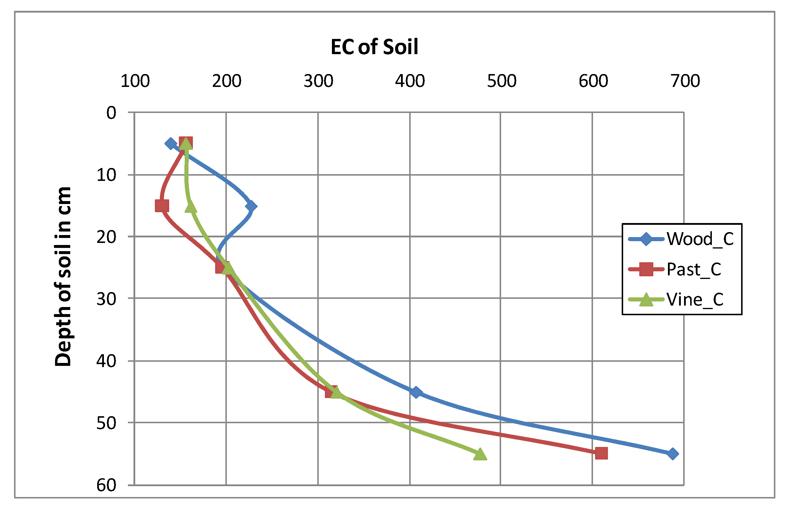
3.2. Effect of LULC on Soil Salinity
| Soil Parameter and Depth | Wood_C n = 60 | Past_C n = 108 | Vine_C n = 19 | F91vine n = 7 | F95vine n = 3 | F2000vine n = 9 | F05vine n = 3 | Aforest n = 18 | Wood2past n = 14 | Others n = 8 |
|---|---|---|---|---|---|---|---|---|---|---|
| EC10 | 139.88 c (23.39) | 156.66 b (17.29) | 156.73 ab (41.22) | 141.93 abc (67.91) | 118.40 abc (103.74) | 126.27 bc (59.89) | 360.57 a (103.74) | 140.09 bc (42.35) | 148.44 bc (48.02) | 138.00 bc (63.53) |
| EC20 | 226.96 a (34.75) | 130.70 a (26.45) | 161.44 a (62.77) | 119.46 a (103.42) | 104.03 a (157.98) | 194.66 a (96.74) | 216.40 a (157.98) | 165.18 cd (64.49) | 152.67 cd (73.13) | 134.73 cd (96.74) |
| EC30 | 196.75 ab (29.65) | 196.62 b (22.97) | 203.20 ab (52.63) | 135.01 ab (88.95) | 110.07 ab (135.88) | 254.48 ab (78.45) | 277.60 ab (135.88) | 279.58 a (55.47) | 155.43 ab (62.90) | 147.40 ab (88.95) |
| EC50 | 407.56 a (39.90) | 314.83 b (30.62) | 320.84 ab (72.66) | 271.61 ab (119.71) | 174.23 ab (182.86) | 397.59 ab (105.57) | 228.37 ab (182.86) | 372.57 a (74.65) | 368.33 ab (84.65) | 277.06 ab (111.98) |
| ECdeep | 686.65 a (66.16) | 610.19 ab (50.13) | 477.74 ab (119.51) | 425.11 ab (196.89) | 189.80 ab (300.76) | 353.15 b (184.18) | 224.27 ab (300.76) | 714.08 a (126.34) | 622.49 a (138.22) | 443.51 ab (196.89) |

3.3. Interrelationships of Soil Quality Indicators with Environmental Covariates

| Axis | Eigenvalue (λ) | % of Total λ | R (Soil, Environment) | Cumulative % Variance (Soil, Environment) |
|---|---|---|---|---|
| Correspondence analysis | ||||
| 1 | 0.161 | 40.3 | 0.212 | 33.5 |
| 2 | 0.099 | 24.8 | 0.302 | 75.5 |
| 3 | 0.083 | 20.8 | 0.184 | 88.5 |
| 4 | 0.044 | 11 | 0.168 | 94.3 |
| Canonical correspondence analysis | ||||
| 1 | 0.011 | 52.4 | 0.313 | 49.5 |
| 2 | 0.007 | 33.3 | 0.232 | 82.2 |
| 3 | 0.003 | 14.3 | 0.187 | 95.5 |
| 4 | 0.001 | 4.8 | 0.146 | 99.8 |
4. Conclusions
Acknowledgments
Author Contributions
Conflicts of Interest
References
- Lambin, E.F.; Turner, B.L.; Geist, H.J.; Agbola, S.B.; Angelsen, A.; Bruce, J.W.; Coomes, O.T.; Dirzo, R.; Fischer, G.; Folke, C.; et al. The causes of land-use and land cover change: Moving beyond the myths. Glob. Environ. Chang. 2001, 11, 261–269. [Google Scholar] [CrossRef]
- Foley, J.A.; Defries, R.; Asner, G.P.; Barford, C.; Bonan, G.; Carpenter, S.R.; Chapin, F.S.; Coe, M.T.; Daily, G.C.; Gibbs, H.K.; et al. Global consequences of land use. Science 2005, 309, 570–574. [Google Scholar] [CrossRef]
- Braimoh, A.K.; Vlek, P.L.G. The Impact of Land Use on Soil Resources. In Land Use and Soil Resources; Braimoh, A.K., Vlek, P.L.G., Eds.; Springer Science Publication: Stockholm, Sweden, 2008; pp. 1–7. [Google Scholar]
- Brian, H. Current Practices and Extension on Acid Soils in NSW. Available online: http://www.anra.gov.au/topics/soils/acidification/index.html (accessed on 4 December 2009).
- Singh, B.; Odeh, I.O.A.; McBratney, A.B. Acid buffering capacity and potential acidification of cotton soils in northern New South Wales. Aust. J. Soil Res. 2003, 41, 875–888. [Google Scholar] [CrossRef]
- Australian Agriculture Assessment Report. Available online: http://www.anra.gov.au/topics/soils/pubs/national/agriculture_contents.html (accessed on 4 December 2009).
- Rengasamy, P. World salinization with emphasis on Australia. J. Exp. Bot. 2006, 57, 1017–1023. [Google Scholar] [CrossRef]
- Pannell, D.J. Dryland salinity: Economic, scientific, social and policy dimensions. Aust. J. Agric. Resour. Econ. 2001, 45, 517–546. [Google Scholar]
- Rengasamy, P. Transient salinity and subsoil constraints to dryland farming in Australian sodic soils: An overview. Aust. J. Exp. Agric. 2002, 42, 351–361. [Google Scholar] [CrossRef]
- Australian Natural Resource Atlas. Available online: http://www.anra.gov.au/topics/salinity/pubs/national/salinity_aus.html (accessed on 4 December 2009).
- National Dryland Salinity Program. Breaking Ground: Key Findings from 10 Years of Australia’s National Dryland Sality Program; Land and Water Australia: Canberra, ACT, Australia, 2004; p. 72.
- James, D. Salinity Management in the Hunter, Case Study Two in Water Quality Management: Five Case Studies; Coastal Zone Inquiry, Resources Assessment Commission: Canberra, ACT, Australia, 1993.
- Fisher, R.J. Local knowledge of dryland salinity in the Hunter Valley, Australia. Indig. Knowl. Dev. Monit. 1995, 3, 13–14. [Google Scholar]
- Faine, J.N.; McBratney, A.; Taylor, J. HWCPIDGIS: A Preliminary Environmental Geographic Information System for the Hunter Wine Country Private Irrigation District. A Draft Report 2001; Australian Centre for Precision Agriculture, University of Sydney: Darlington, NSW, Australia, 2006. [Google Scholar]
- Creelman, R.A.; Cooke, R.; Simons, M. Salinity and Resource Management in the Hunter Valley. In Proceedings of 29th Newcastle Symposium, Advances in the Study of the Sydney Basin, Newcastle, NSW, Australia, 6–9 April 1995.
- Braimoh, A.K.; Vlek, P.L.G. The impact of land cover change on soil properties in northern Ghana. Land Degrad. Dev. 2004, 15, 65–74. [Google Scholar] [CrossRef]
- Gong, J.; Chen, L.; Fu, B.; Huang, Y.; Huang, Z.; Peng, H. Effect of land use on soil nutrients in the Loess Hilly Area of the Loess Plateau, China. Land Degrad. Dev. 2006, 17, 453–465. [Google Scholar] [CrossRef]
- Odeh, I.O.A.; Chittleborough, D.J.; McBratney, A.B. Elucidation of soil-landform interrelationships by canonical ordination analysis. Geoderma 1991, 49, 1–32. [Google Scholar] [CrossRef]
- Taghizadeh-Mehrjardi, R.; Minasny, B.; Sarmadian, F.; Malone, B.P. Digital mapping of soil salinity in Ardakan region, central Iran. Geoderma 2014, 213, 15–28. [Google Scholar] [CrossRef]
- Bilgili, A.V. Spatial assessment of soil salinity in the Harran Plain using multiple Kriging techniques. Environ. Monit. Assess. 2013, 185, 777–795. [Google Scholar] [CrossRef]
- Shaw, P.J.A. Basic Concepts in Ordination. In Multivariate Statistics for the Environmental Sciences; Hodder Arnold, Holder Headline Group: London, UK, 2003; Chapter 4; pp. 73–82. [Google Scholar]
- Ter Braak, C.J.F. Canonical correspondence analysis: A new eigenvector technique for multivariate direct gradient analysis. Ecology 1986, 67, 1167–1179. [Google Scholar]
- Ter Braak, C.J.F. Ordination. In Data Analysis in Community and Landscape Ecology; Jongman, R.H.G., Ter Braak, C.J.F., van Tongeren, O.F.R., Eds.; Press Syndicate of the University of Cambridge: Cambridge, UK, 1995; Chapter 5; pp. 91–173. [Google Scholar]
- Palmer, M.W. Putting things in even better order: The advantages of canonical correspondence analysis. Ecology 1993, 74, 2215–2230. [Google Scholar] [CrossRef]
- Graffelman, J.; Tuft, R. Site scores and conditional biplots in canonical correspondence analysis. Environmetrics 2004, 15, 67–80. [Google Scholar] [CrossRef]
- Zhang, J.; Oxley, R.R.B. A comparison of three methods of multivariate analysis of upland grasslands in North Wales. J. Veg. Sci. 1994, 5, 71–76. [Google Scholar] [CrossRef]
- Salles, J.F.; van Veen, J.A.; van Elsas, J.D. Multivariate analyses of Burkholderia species in soil: Effect of crop and land use history. Appl. Environ. Microbiol. 2004, 70, 4012–4020. [Google Scholar] [CrossRef]
- Stèphane, D.; Sonia, S.; François, D. Spatial ordination of vegetation data using a generalization of Wartenberg’s multivariate spatial correlation. J. Veg. Sci. 2008, 19, 45–56. [Google Scholar] [CrossRef]
- Glass, G.V.; Peckham, P.D.; Sanders, J.R. Consequences of failure to meet assumptions underlying the fixed effects analyses of variance and covariance. Rev. Educ. Res. 1972, 42, 237–288. [Google Scholar] [CrossRef]
- Bentler, P.M. Covariance structure analysis—Statistical practice, theory and directions. Annu. Rev. Psychol. 1996, 47, 563–592. [Google Scholar] [CrossRef]
- Kenkel, N.C.; Derksen, D.A.; Thomas, A.G.; Watson, P.R. Review: Multivariate analysis in weed science research. Weed Sci. 2002, 50, 281–292. [Google Scholar] [CrossRef]
- Qiu, Y.; Fu, B.; Wang, J.; Chen, L. Soil moisture variation in relation to topography and land use in a hillslope catchment of the Loess Plateau, China. J. Hydrol. 2001, 240, 243–263. [Google Scholar] [CrossRef]
- Fu, B.J.; Zhang, Q.J.; Chen, L.D.; Zhao, W.W.; Gulinck, H.; Liu, G.B.; Yang, Q.K.; Zhu, Y.G. Temporal change in land use and its relationship to slope degree and soil type in a small catchment on the Loess Plateau of China. Catena 2006, 65, 41–48. [Google Scholar] [CrossRef]
- Manandhar, R.; Odeh, I.; Ancev, T. Improving the accuracy of land use and land cover classification of Landsat data using post-classification enhancement. Remote Sens. 2009, 1, 330–344. [Google Scholar] [CrossRef]
- Odgers, N.P. Bottom-up Digital Soil Mapping. Ph.D. Thesis, The University of Sydney, Darlington, Australia, 2010. [Google Scholar]
- Minasny, B.; McBratney, A.B. A conditioned Latin hypercube method for sampling in the presence of ancillary information. Comput. Geosci. 2006, 32, 1378–1388. [Google Scholar] [CrossRef]
- McKenzie, N.J.; Gessler, P.E.; Ryan, P.J.; O’Connell, D.A. The Role of Terrain Analysis in Soil Mapping. In Terrain Analysis: Principles and Applications; Wilson, J.P., Gallant, J.C., Eds.; John Wiley & Sons, Inc.: New York, NY, USA, 2000; Chapter 10; pp. 245–265. [Google Scholar]
- Taylor, J.A. Digital Terroirs and Precision Viticulture: Investigations into the Application of Information Technology in Australian Vineyards. Ph.D. Thesis, University of Sydney, Darlington, NSW, Australia, 2004; p. 255. [Google Scholar]
- Gallant, J.C.; Wilson, J.P. Primary Topographic Attributes. In Terrain Analysis: Principles and Applications; Wilson, J.P., Gallant, J.C., Eds.; John Wiley & Sons, Inc.: New York, NY, USA, 2000; Chapter 3; pp. 51–85. [Google Scholar]
- Ter Braak, C.J.F.; Šmilauer, P. CANOCO Reference Manual and CanoDraw for Windows User’s Guide: Software for Canonical Community Ordination (Version 4.5); Microcomputer Power: Ithaca, NY, USA, 2002; p. 500. [Google Scholar]
- JMP Statistics and Graphics Guide. Release 6; SAS Institute Inc.: Cary, NC, USA, 2005.
- Minasny, B.; McBratney, A.B. Spatial prediction of soil properties using EBLUP with the Matern covariance function. Geoderma 2007, 140, 324–336. [Google Scholar] [CrossRef]
- Khresat, S.; Al-Bakri, J.; Al-Tahhan, R. Impacts of land use/cover change on soil properties in the Mediterranean region of Northwestern Jordan. Land Degrad. Dev. 2008, 19, 397–407. [Google Scholar] [CrossRef]
- Fitzpatrick, R.W.; Wright, M.J.; Stevens, R.M. Drainage, Sodicity and Related Problems of Vineyard Soils. In Proceedings of the Eighth Australian Wine Industry Technical Conference, Melbourne, Australia, 25–29 October 1992; pp. 38–44.
- Cass, A.; Walker, R.R.; Fitzpatrick, R. Vineyard Soil Degredation by Salt Accumulation and the Effect on the Performance of the Vine. In Proceedings of the Ninth Australian Wine Industry Technical Conference, Adelaide, SA, Australia, 16–19 July 1995; pp. 153–160.
- Greenacre, M. Correspondence Analysis Biplots. In Correspondence Analysis in Practice; Chapman & Hall/CRC Taylor & Francis Group: London, UK, 2007; Chapter 13; pp. 97–104. [Google Scholar]
- Jia, G.; Wang, C.; Wang, G. Microbial biomass and nutrients in soil at the different stages of secondary forest succession in Ziwulin, Northwest China. For. Ecol. Manag. 2005, 217, 117–125. [Google Scholar] [CrossRef]
© 2014 by the authors; licensee MDPI, Basel, Switzerland. This article is an open access article distributed under the terms and conditions of the Creative Commons Attribution license (http://creativecommons.org/licenses/by/3.0/).
Share and Cite
Manandhar, R.; Odeh, I.O.A. Interrelationships of Land Use/Cover Change and Topography with Soil Acidity and Salinity as Indicators of Land Degradation. Land 2014, 3, 282-299. https://doi.org/10.3390/land3010282
Manandhar R, Odeh IOA. Interrelationships of Land Use/Cover Change and Topography with Soil Acidity and Salinity as Indicators of Land Degradation. Land. 2014; 3(1):282-299. https://doi.org/10.3390/land3010282
Chicago/Turabian StyleManandhar, Ramita, and Inakwu O. A. Odeh. 2014. "Interrelationships of Land Use/Cover Change and Topography with Soil Acidity and Salinity as Indicators of Land Degradation" Land 3, no. 1: 282-299. https://doi.org/10.3390/land3010282
APA StyleManandhar, R., & Odeh, I. O. A. (2014). Interrelationships of Land Use/Cover Change and Topography with Soil Acidity and Salinity as Indicators of Land Degradation. Land, 3(1), 282-299. https://doi.org/10.3390/land3010282