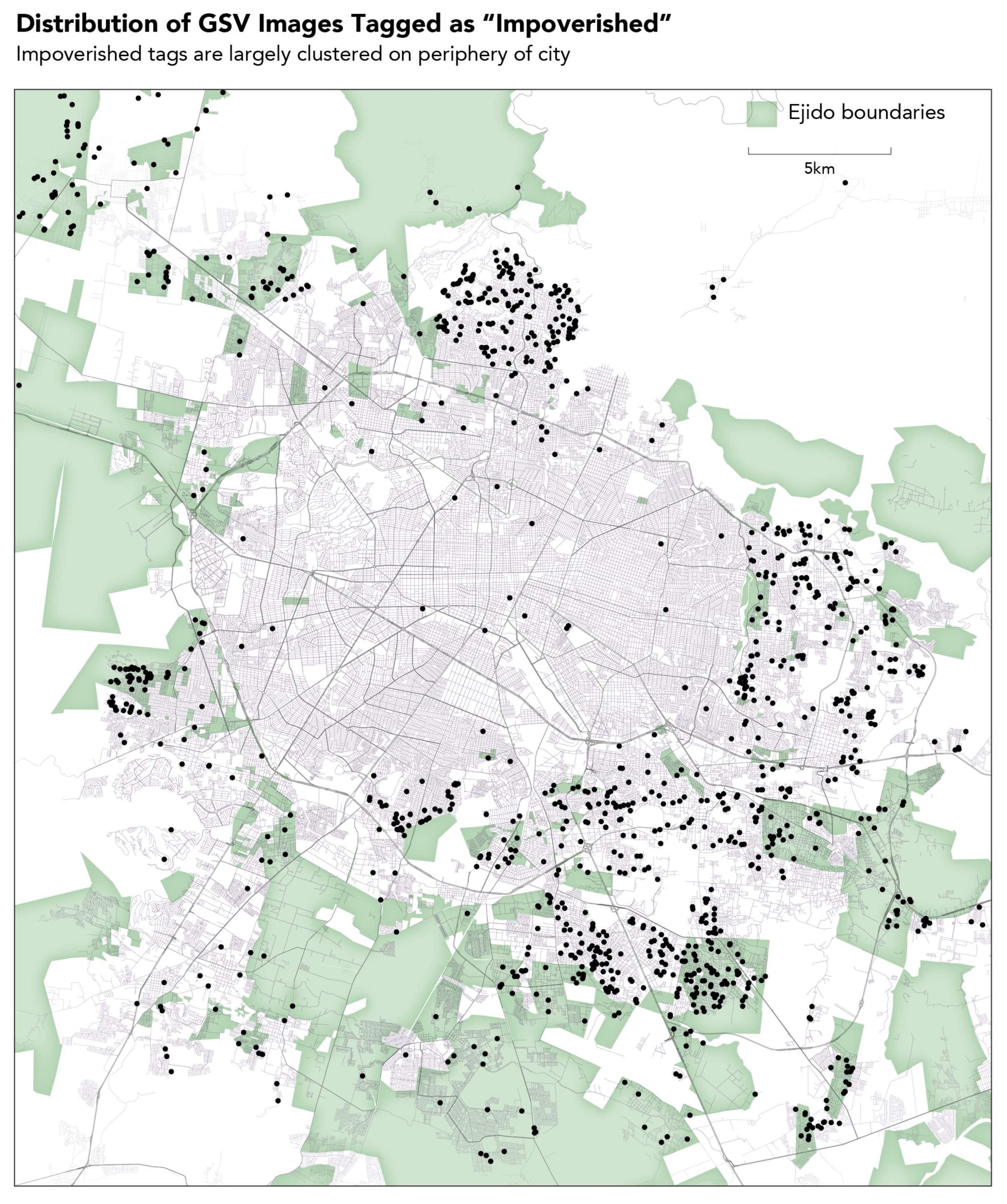
For the metropolitan region of Guadalajara, our sample includes 3133 images of ejidal land. There are 1186 GSV images tagged as “impoverished” using the methods described in the previous section—30.94 percent of these images are part of ejidos/zones.
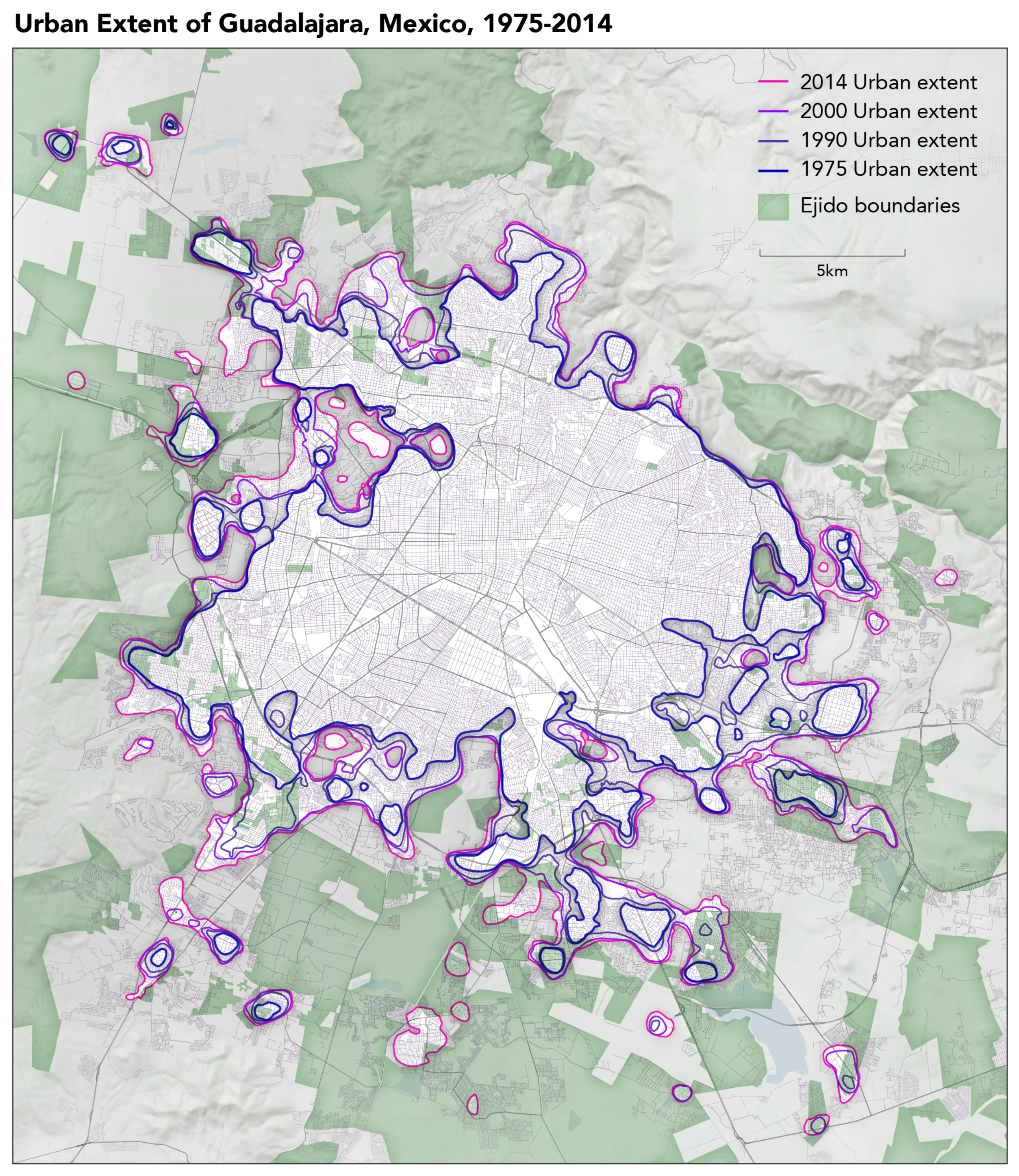
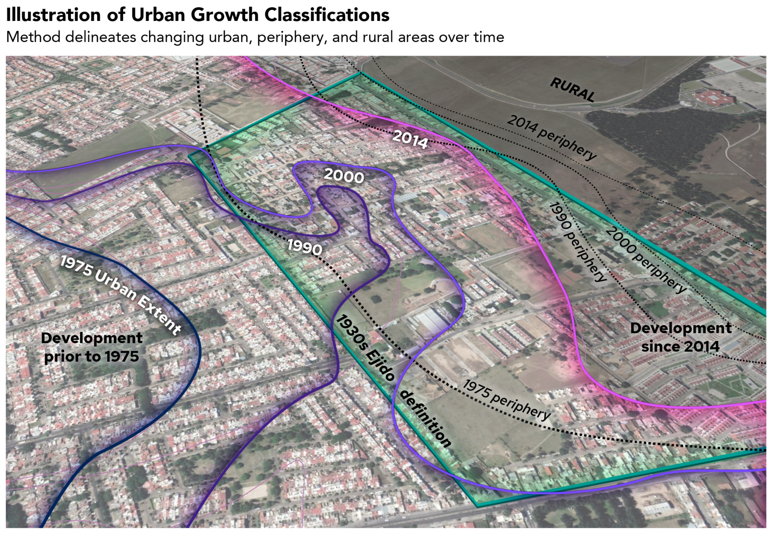
When plotted on a map, the distribution of these tagged images tells an unambiguous story of the peripheralization of poverty in the AMG. By overlaying the GSV points with data from RS, we can identify the time period during which the locations in question first began to shift from rural to urban landscapes. Whereas there are scattered images tagged as impoverished throughout the metropolitan area, most of the points appear in clusters around the periphery of the central city in areas that only became urbanized beginning in the 1970s.
Of the points strongly associated with impoverishment at the level of 0.85 or higher, 641 are within the band of urbanization derived from RS data for 2014. Five hundred and eighty-eight are within the band of 1975 (some overlap with 2014 data). Only 107 of 1186 points fall within the core urban zone that was built up prior to 1975, a result which strongly indicates the importance of timing and historical nature of land use change. An additional 130 are outside either band. In other words, 237 points tagged as impoverished are not in the peripheral growth areas identified by RS. The vast majority of such points, therefore, fall in the zones of urban expansion from 1975 to the present.
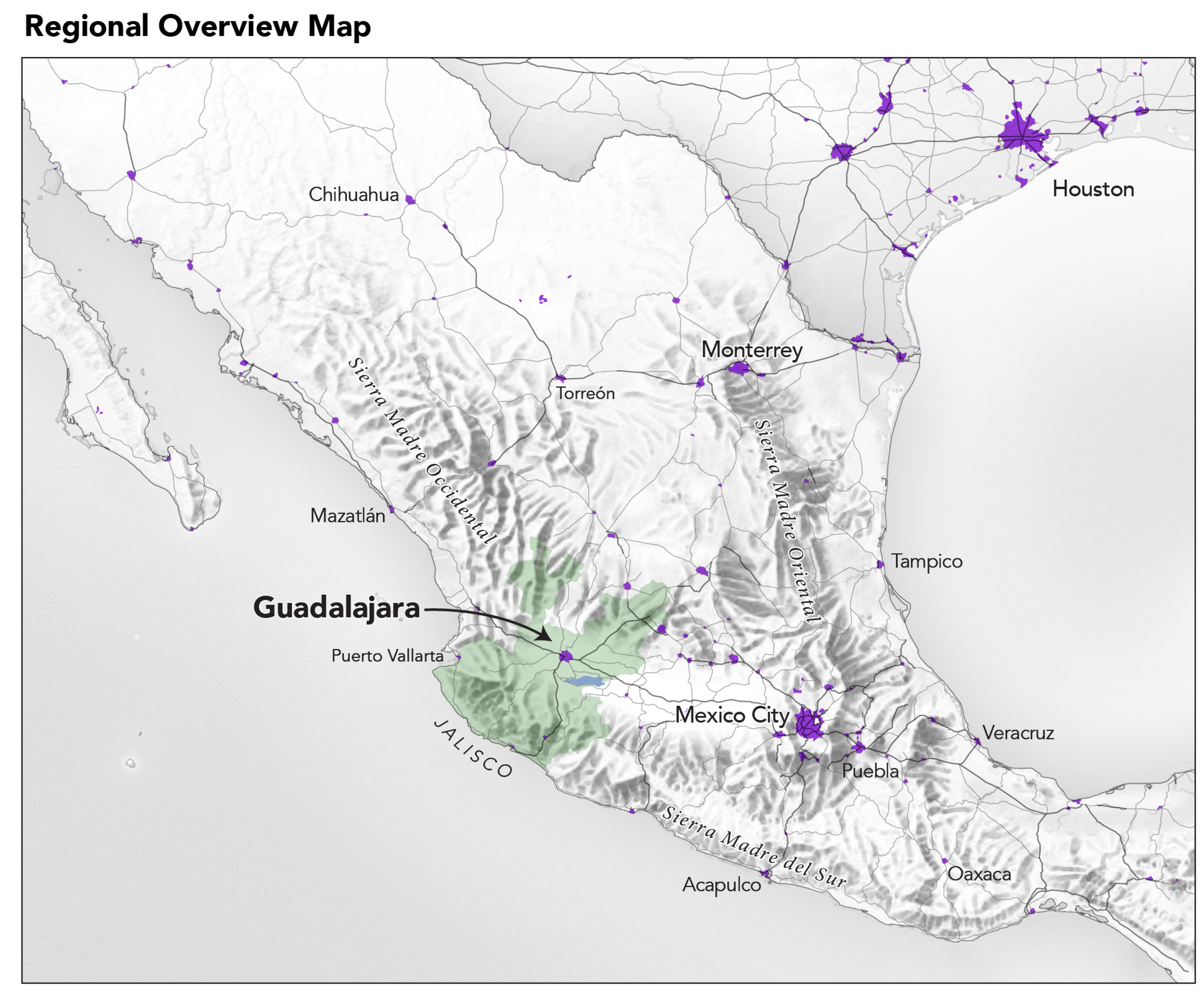
3.1. The Urban Periphery and the Ejidos of the AMG
As we have indicated, poverty is produced or extruded at the edge of urban agglomerations. Understandably, the related literature has tended to focus on the dynamic forces emanating from central cities and pushing the poor and working class to the margins. Yet, there is another equally important story to tell. The expansion of Guadalajara reveals a process by which vital agricultural lands and traditional agricultural communities are transformed into poor, often informal housing with little or no visible agricultural potential remaining in the zones of occupation. Much of this urbanization can best be described as occurring through a process of accretion rather than extrusion, as migrants from rural areas and smaller towns arrive on the periphery and find themselves unable to find housing within the incorporated and fully built up urban setting of the city proper [
45].
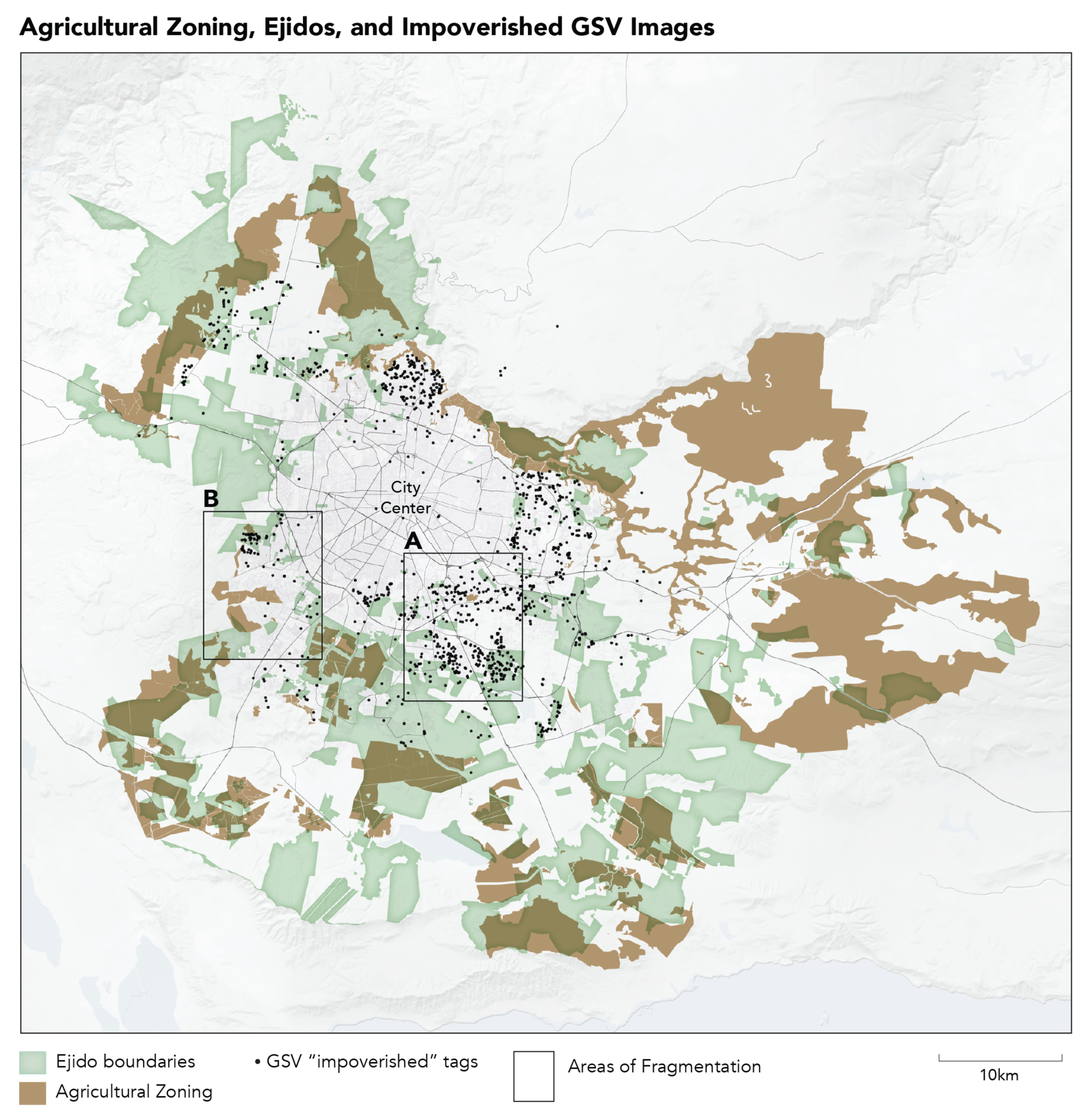
When the GSV points tagged as indicating impoverished urban landscapes are plotted against the territories of the ejidal lands surrounding Guadalajara, we find that 367 (31 percent) of them are within the boundaries of these formerly agricultural areas (
Figure 7).
In order to further illustrate the evolution of landscapes in Guadalajara,
Figure 8 presents the ratio of GSV images tagged for either “impoverished” or “invested” in over time and according to the underlying classification of the land use regime (rural, periphery, urban). The ratio here is derived by joining tagged observations to a 100-m grid overlaid on the entire metropolitan region. Ejidal lands contain a consistently higher ratio of impoverished landscapes across all land use classifications. In addition, this analysis highlights the way that early disturbances in the rural fabric, that is ejidos that experience encroachment of urbanization in the 1970s and 1980s, appear to lead to much higher concentrations of impoverished landscapes in contemporary GSV images.
3.2. Modeling Changing Land Use with RS, GSV Imagery, and Contextual Spatial Data
Viewed broadly, patterns of land use and urbanization revealed in
Figure 7 and
Figure 8 raise questions of local versus regional factors, general versus idiosyncratic forces, as well as issues relating to the temporal sequence of change. In order to address these questions and clarify the manner in which these variables and processes interact, regression analysis provides insight into the possible relationship between patterns of urban expansion and the subsequent production of housing vulnerability. We begin with the following nested set of hypotheses:
The presence of substantial “peripheral” urban growth in a given ejido or community during the 1970s will be associated with a greater number of GSV images tagged as impoverished in the 2010s. A longer period of peripheral growth produces a greater density of impoverishment. Note that we focus here on the peripheral, which in this context is defined as land use that is neither clearly urban nor clearly rural, and is located at the margin of the unambiguously urban core.
Peripheral growth precedes and predicts levels of urban consolidation. This hypothesis rests on the notion that urbanization in the ejidos and other peripheral zones of Guadalajara was a gradual and unplanned process rather than the kind of process that would result in rapid and definitive urbanization in a short period of time. As such, this is a story that unfolds on the timescale of decades, not years.
Density of impoverished GSV images is going to be associated with greater recent measures of urbanization.
As with the first hypothesis, we also expect that peripheral urbanization in the 1970s will strongly predict major loss of (potential) agricultural land within a given ejido or community. Again, the logic of the argument hinges upon the idea that land use changes are cumulative and possibly compounding over time.
We begin with a simple test of the first hypothesis. The model asks whether the extent of the area within a contemporary ejido that was coded as “peripheral” in our RS data for 1975 can help to predict the presence of impoverished landscapes revealed by GSV images today. The spatial container for these calculations is the ejido.
The dependent variable GSVimp refers to all tagged images denoted at impoverished by our machine learning model at 85 percent confidence. The variable Periphery 1975 refers to the area in a given ejido or government-designated agricultural area in the AMG that we classified as a zone of incipient urbanization (peripheral growth) on the basis of RS data. A simple OLS regression shows that there is a substantial and positive relationship between the early presence of peripheral urbanization and present-day landscapes of impoverishment (
Table 2). We take this as plausible confirmation of the intuition behind our first hypothesis. This suggests that there is a deeper history to the impoverished landscapes in Guadalajara than would be immediately obvious either on the basis of the GSV images alone or on the basis of common narratives about the onset and intensity of disruption in ejidal lands during the 1980s and especially the “neoliberal” 1990s.
The analysis in
Table 3 confirms our intuition that early histories of peripheral urbanization drive subsequent processes of urban consolidation and explain the variation in the urbanized area of formerly agricultural zones of the AMG. More area in the 1975 periphery translates strongly into more area in the 2014 urban-defined category. Meanwhile, by contrast, in the case of the Periphery 2000 measure, this is negatively associated with the total area in consolidated urban settlement as of 2014, indicating that the process is still in the early phase in the ejidos where such “new” settlement is salient.
The results reported in
Table 4 confirm that areas that have become
fully urbanized more recently are more likely to contain GSV images tagged as impoverished. Where there were already significant urban areas as of 1975 (in contrast to significant peripheral areas), the relationship turns negative, indicating that the oldest urbanized zones in the periphery (as of 1975) have matured to a point where there are fewer impoverished landscapes. The contrast here with the results indicated with respect to the presence of Periphery 1975 is striking. Where urbanization was incipient circa 1975, we see a strong tendency toward the presence of impoverished urban landscapes in formerly agricultural lands.
3.3. Peripheral Urbanization and the Loss of Agricultural Lands in the Ejidos of the AMG
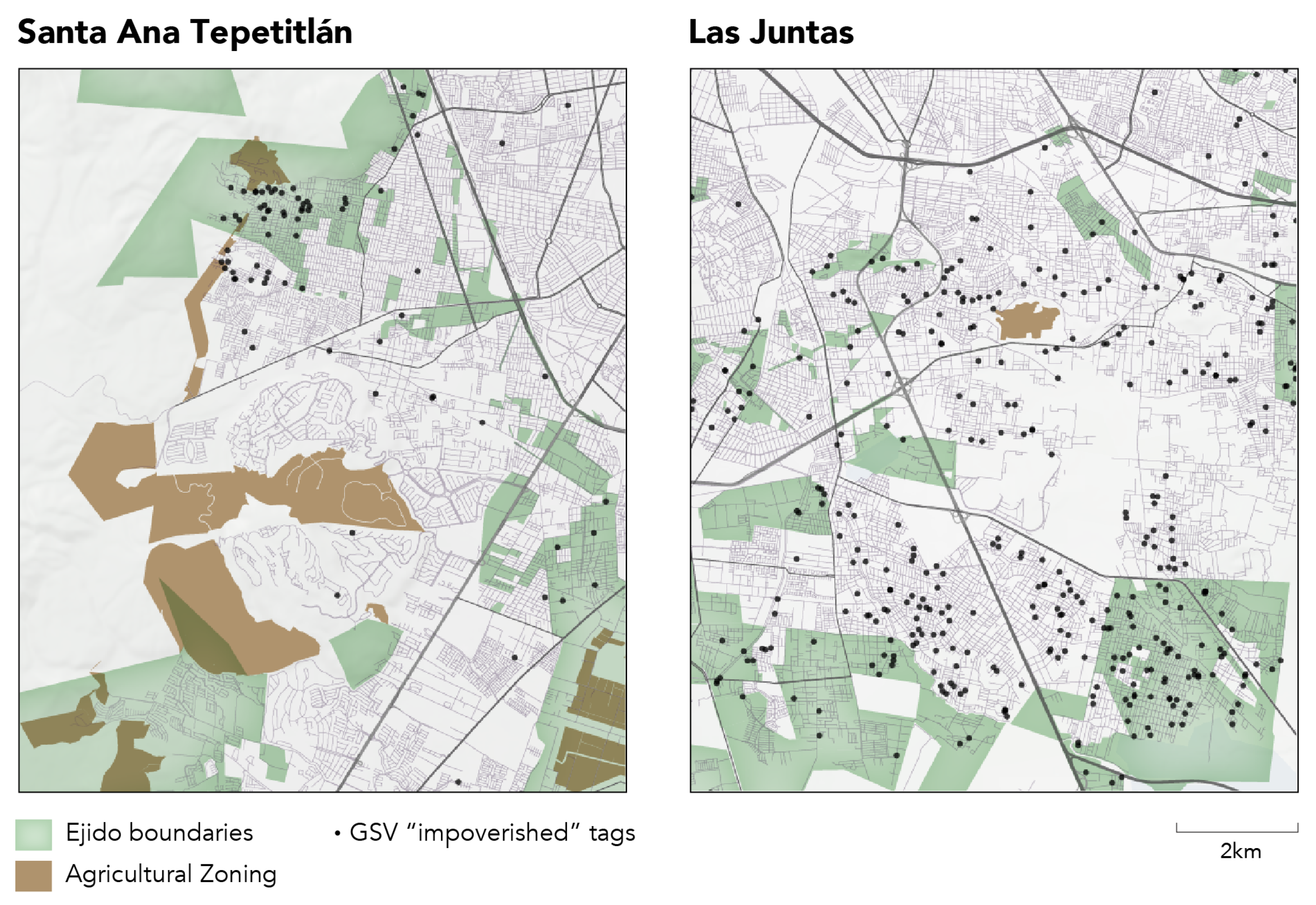
Visual inspection of the current distribution of land zoned primarily for agricultural use, the present boundaries of ejidos, and the location of impoverished GSV tags tells a clear story. Where the urban periphery has expanded since the 1970s it now abuts or encircles the remaining agricultural land. Clear evidence of the fragmentation of ejidos can also be seen in areas where there are a concentration of impoverished GSV tags. On the other hand, it is also evident that areas of urban sprawl and impoverishment are sometimes, though not predominantly, located near the agricultural perimeter, perhaps indicating some residual access to land or the food it produces.
Readers should remember that all of the area bounded in grey polygons in
Figure 9 is legally defined as ejidal land or other related agricultural settlements. Historically, starting in the decades prior to the Second World War, all of this area was originally meant to be designated for agriculture, particularly small-scale. Most of the area within the ejidos surrounding the urban core is no longer zoned explicitly for agricultural use.
The arrival of migrants, in increasing numbers from the 1970s onward, shifted the urban periphery into the ejidos located closest to the urban center. GSV tagged images cluster in areas that show significant fragmentation (degradation of ejidal continutity), which, in turn, appear to be areas where agriculture is absent or in the process of encroachment and decline. Example regions are denoted in the map as “areas of fragmentation”, where ejidos have been broken apart by expropriation following degradation of agriculture and its replacement by informal housing. On a large scale, this “shattered” urban/rural space corresponds to the concept of urban fragmentation developed in García-Ayllón’s recent study of five Latin American cities [
46].
The GSV cluster indicated to the southeast of the city center is focused around the ejido of Las Juntas. The cluster indicated on the western edge is Santa Ana Tepetitlán. Both of these ejidos trace their origins to land reforms during the early period following the conclusion of the Mexican Revolution.
The ejido of Santa Ana Tepetitlán was formed in 1924, with 2178 hectares being distributed as of 1926 [
47]. The ejido grant was augmented in 1966, suggesting some continued agricultural vitality at this late date, by an increase of 641 hectares [
47]. Within a decade of this expansion, the first expropriation of 275 hectares occurred during the Echeverría regime in 1976. The official reason for the federal government’s expropriation of ejidal land was to “improve existing [unauthorized] settlements by formalizing and legalizing land tenure through the sale of parcels to residents who currently occupy them and the sale of any unclaimed parcels to third parties, as well as the creation of a reserve of land to fulfill the future planned, sustained growth of the aforementioned communities” (expropriation requested by the
Comisión para la Regularización de la Tenencia de la Tierra) [
48]. As of 1991, the official population of ejidatarios was a mere 456 in a context where multiple expropriations for urban formalization were on the near horizon. The official and nominally agricultural residents were a tiny minority at this point [
49]. Two more large expropriations took place in 1992 (344 ha) and 1996 (325 ha), both of which involved the same logic of formalizing urban settlement on the periphery of the city [
47]. These expropriations resulted in the loss of about one third of the ejido’s total hectares, leaving a gerrymandered remnant with limited agricultural zoning present, according to the AMG zoning plan. The process described here and evident in the combined RS, GSV and zoning data follows the general outline of the logic of migrant incorporation through informal urbanization described in Hernando de Soto’s influential study
The Other Path [
50]. Although de Soto’s work has been criticized in the literature, the sequence of invasion, occupation, informal development, and final government recognition as a
fait accompli is the most reasonable and parsimonious explanation for the fragmentation of agricultural lands in the ejidos surrounding Guadalajara.
The pulverization of Las Juntas tells a similar tale of dismemberment and loss of agricultural land owing to urban sprawl. Founded in 1936 on 859 hectares granted by the Cárdenas regime, Las Juntas began the process of fragmentation via expropriation in the same year, 1976, as Santa Ana Tepetitlán, with a loss of 103 hectares for the purpose of formalizing informal urban settlements [
51]. Additional major expropriations for the same purpose, of 224 hectares and 70 hectares, followed in 1993 and 2003, respectively [
51].
In order to place these two ejidos and their history of land use change in broader perspective, we collected similar data for an additional eight ejidos distributed around every side of the metropolitan core (sampled ejidos denoted in italics in the data appendix). In this sample of ten communities, we found that four were created between 1917 and 1934, before the major land reform associated with the Cárdenas presidency. Five ejidos were created during Cárdenas’s regime (1934–1940), and one was created much later, in 1970. Eight out of ten ejidos in the sample suffered at least one expropriation by the government. Contrary to the idea that these land use changes began after a watershed reform in 1992 during the Salinas administration, our sample indicates that some expropriatons sanctioned by the Mexican government took effect in all eight of these ejidos prior to the Salinas reforms. The reasons given for expropriation ranged from the "formalization" of existing informal settlement in these peripheral zones bounding the metropolitan core, as was the case in Los Ranchitos in 1976, to other forms of expropriation linked to urban growth, such as an airport expansion in El Verde in 1975 [
52,
53,
54].
Fragmentation of ejidal lands appears clearly when we zoom in to look at the specific cases of Santa Ana and Las Juntas. For instance, the entire middle section of Santa Ana has disappeared in the
Figure 10. The upper left and lower right green polygons both belong to the ejido, but most of the land in between is now fully urbanized. In keeping with our findings regarding land tenure regimes and levels of impoverishment, the GSV tags are clearly clustered in or near the two remaining areas of ejidal land. Spaces that have resisted formal incorporation into the urban zone also remain the primary spaces for concentrations of informal housing. A similar, if less striking pattern appears in Las Juntas.


