Article

Near-Infrared Spectroscopic Study of Heavy-Metal-Contaminated Loess Soils in Tongguan Gold Area, Central China

1
Key Laboratory for Geohazards in Loess Areas, Chinese Ministry of Natrual Resources, Xi’an 710054, China
2
Xi’an Centre of China Geological Survey, Xi’an 710054, China
3
Shaanxi Tongguan Observation Base on Geological Environment of Mines, MNR, Xi’an 710054, China
4
Shaanxi Ziyang Base of Science Popularization on Strata type Section for the Bottom of Wenlock, MNR, Xi’an 710054, China
5
Instrumental Analysis Center of Xi’an Jiaotong University, Xi’an 710049, China
*
Author to whom correspondence should be addressed.
Minerals 2020, 10(2), 89; https://doi.org/10.3390/min10020089
Submission received: 16 December 2019 / Revised: 8 January 2020 / Accepted: 19 January 2020 / Published: 21 January 2020

Abstract

:
Loess soil is a kind of widespread soil type in northwest China. Human engineering activities such as mining have caused numerous problems related to heavy metal pollution in soils, which threaten people’s health. The band formation mechanism of the near-infrared (NIR) spectral features in loess soils forms the theoretical basis for the study of the soil environment by hyperspectral remote sensing. Some NIR features of loess soils will shift because of the variations of the soil composition and microstructure after they adsorb heavy metal cations. In this study, we focused on the heavy metal adsorption of the illite, smectite, and illite–smectite (I/S) mixed layer in loess soils; evaluated the pollution by Nemerow indexing; applied X-ray diffraction (XRD), mid-infrared (MIR) spectral analysis, and inductively coupled plasma mass spectrometry (ICP-MS); and carefully observed the shift behavior of the MIR and NIR features. Then, the NIR bands were assigned to MIR bands according to the vibration behavior. Furthermore, the relationships between the NIR band positions and the six heavy metal cations as well as the Nemerow index were investigated via multiregression and simple linear correlation methods. Finally, the relationship obtained from the experiments was analyzed using the physical and chemical mechanisms of the heavy metal cations in the clay minerals. These findings may benefit the application of NIR and remote sensing techniques for detecting heavy-metal-polluted soils.

1. Introduction

Soil is a loose material layer on the Earth’s surface that provides habitats for green plants, animals, and microorganisms [1]. The soil environment is a critical factor related to the ecological balance and the safety of human health. During the last three decades in China, mineral exploration, especially metallic mineral exploitation, has added various inorganic and organic substances into the soil. Heavy metal pollution of the soil environment has become one of the most serious problems influencing the ecological environment of the mining areas or even entire mining cities [2,3]. Numerous studies of soil with heavy metal pollution have been reported using traditional chemical analyses such as colorimetric analysis, flame emission spectrometry, atomic absorption spectrometry, and so forth. Although these laboratory methods show high accuracy, the sample preparation and analysis processes are time and labor consuming [4].
Near-infrared (NIR) spectroscopy is a kind of molecular vibration spectroscopy related to the overtone and combination vibrations. It shows diagnostic features with vibrational information of hydrogen groups (C–H, O–H, S–H, N–H, etc.) and carbonate groups (CO32−). The variation mechanism and regularity of soil NIR spectroscopy after heavy metal adsorption represent hot spots as well as trouble areas in the field of NIR analysis. At present, most hyperspectral imagers, including AVIRIS, Hymap, CASI/SASI, Hyperion, and Chinese Tiangong-1, can collect spectral images ranging from the visible to the near-infrared region. As one of the most important components of soils, clay minerals, including illite, smectite, kaolinite, and so forth, provide many diagnostic features in the NIR region. Furthermore, studying the variation mechanism and regularity of NIR spectral bands in soils polluted by heavy metals has become the theoretical basis that guides the application of remote sensing data in rapid monitoring and large-scale observation for soil quality surveys.
Malley and Williams firstly used partial least-squares regression (PLSR), a kind of statistical method, to establish statistical models between NIR and chemical component data [5]. Further studies of NIR for predicting soil pollution caused by heavy metals focused on a variety of statistical methods, including principal component regression (PCR), stepwise multiple linear regression (SMLR), artificial neural networks (ANNs), support vector machine regression (SVMR), and genetic-algorithm-based PLSR (GA-PLSR) [6,7,8,9]. Prediction methods for soil heavy metal contamination via NIR spectroscopy, from the initial linear statistical methods to the recently advanced linear–nonlinear combination approaches, have been able to provide reliable prediction results for the investigation of heavy metal pollution in soils. However, these statistical methods only have reliable efficiency in a limited area with similar soil types, and they are difficult to apply in large-scale regions. Clay minerals such as illite, smectite, and the illite–smectite (I/S) mixed layer are widespread in many types of soils, while other major minerals including quartz, feldspar, and kaolinite have poor adsorption capacity under natural occurrence conditions. Therefore, focusing on the adsorption ability of illite, smectite, or the mixed layer in soils and studying the mechanism of the NIR band shift caused by the adsorption of heavy metals may bridge the gap among the NIR technique, the hyperspectral remote sensing technique, and heavy metal pollution in soils.
Loess is widely distributed around the world, covering about 10% of the Earth’s surface and mainly deposited in the temperate and semiarid zones adjacent to desert areas. Its geographical region is located at about 30°–55° of north latitude and 30°–40° of south latitude. China’s loess areas are mainly distributed in the Loess Plateau, which has a continuous coverage area of about 273,000 km2 and covers about 62% of the total distribution area of China’s loess. Some studies have investigated the clay components in the loess in China and the results indicate that illite (55%–75% of total clays), smectite (10%–25% of total clays), and kaolinite and chlorite (10%–29% of total clays) are the principle clay minerals [10].
Illite, smectite, or I/S mixed layer minerals are all 2:1 phyllosilicates that are widespread in soils. The crystal structure of illite and smectite can be described as one octahedral sheet “sandwiched” between two opposite tetrahedral sheets with an extra interlayer (Figure 1). The significant difference between illite and smectite is the adsorption ability of the interlayers. The interlayers of illite are mainly filled by K+, while the interlayers of smectite are filled by many kinds of metal cations or even water molecules. Therefore, the adsorption capacity of smectite is much greater than illite. The I/S mixed layer represents a transitional mineral between illite and smectite composed of illite and smectite crystalline layers along the C axis (plane normal) or perpendicular to the (001) direction (Figure 1). Therefore, the adsorption ability of illite–smectite mixed layers consisting of 2:1 layers, K+-filled interlayers, and other interlayers filled with cations should be between illite and smectite.
Most of the available vibrational spectral studies of heavy-metal-polluted soils with illite, smectite, and I/S mixed layers have focused on the mid-infrared (MIR), Raman, and other vibrational spectra, and the relationships between peak positions and heavy metal content have been established [11,12,13]. Only a limited number of near-infrared spectroscopic studies based on band features have been implemented that determined the band attributions [14] and discussed the relationship between the band depth and the metallic ions [15], but the relationship between the band shift and the metallic cations was not mentioned.
The aim of this study was to contrast NIR data with metallic cation content, establish the relationship between the band locations and the metallic cation content, and analyze the occurrence mechanism of the band shift initiated by heavy metal contamination in loess soils. NIR reflectance data, particularly due to their fast and efficient characteristics, can contribute to monitoring the heavy metal pollution of loess soils in northwest China when observing the Earth’s surface via multi- or hyperspectral remote sensing.

2. Materials and Methods

2.1. Samples

A series of soil samples was collected from the agricultural area of Tongguan County in the east part of Shaanxi Province, where gold mines have been exploited for over three decades, causing serious heavy metal pollution. Each sample was collected at a depth near 25 cm and mixed with the soils from three sampling holes around the sampling point. The MIR and NIR spectral data were firstly collected without sample treatment. Furthermore, 0.1 g of each soil sample was air-dried and ground to 0.15 mm in diameter (100 mesh) in a polytetrafluoroethylene (PTFE) crucible. Next, a few drops of water were added, followed by 3 mL of nitric acid and 3 mL of hydrofluoric acid. The samples were steamed to near-dry at 220 °C on a heating plate, 1 mL of HClO3 was added, and they were then dried. Subsequently, they were redissolved with 1 mL of aqua regia in a 100 mL volumetric flask. Finally, the processed samples were analyzed on an inductively coupled plasma mass spectrometry (ICP-MS) instrument.

2.2. XRD Analysis

Three of the total 28 samples were ground to 200 mesh (0.074 mm in diameter) and then analyzed with a D/MAX 2500 X-ray diffraction (XRD) spectrometer (Rigaku Co., Tokyo, Japan) at room temperature using Cu Kα radiation at 40 kV and 100 mA (Key Laboratory for Geohazards in Loess Areas, Chinese Ministry of Natural Resources, Xi’an, China). The speed of the scanning was 1/2 °2θ per minute and the chart speed was 1/2 inch per minute, providing 1° 2θ per inch printout for all samples. XRD patterns were smoothed slightly and backgrounds were subtracted using Jade 6.0 software [16,17].

2.3. MIR Spectroscopy

MIR spectra (Bruker Co., Ettlingen, Germany) were acquired from the soil samples using a Bruker VERTEX 70 IR spectrometer equipped with an attenuated total reflection (ATR) probe. The samples were contacted against the ATR diamond crystal with a force of push of 420 N over a 1.5 mm2 sampling area. Two regions—from 400 to 1500 cm−1 and from 1500 to 4000 cm−1—were used for spectral analysis in this study.

2.4. NIR Spectroscopy

All NIR spectral data were provided by a PANalytical ASD FieldSpec Pro® 3 spectrometer (PANalytical B.V., Malvern, UK) (hereinafter referred to as ASD) with a spectral range from 350 to 2500 nm wavelength (4000–28,571 cm−1). The spectral resolution in the region from 1300 to 2500 nm was 10 nm and the sampling interval was 1 nm. The spectrometer was equipped with a touch probe with an internal halogen bulb fixed in it, which provided stable illumination conditions during data collection. The raw values from the sensor were converted to surface reflectance values using a white reflectance panel, which is commercially available and made of PTFE [18]. Then, the relative reflectance values of each wavelength were multiplied with the reflectance factor obtained from the calibration certificate of the Spectralon™ panel in order to convert to absolute reflectance values [19]. The wavelengths of the NIR spectra were converted to wavenumbers to facilitate the comparison with the MIR data.

2.5. Heavy Metal Component, Total Organic Carbonate Content, and pH Analyses

The ICP-MS analysis (Agilent, Santa Clara, CA, USA) for the heavy metal components, including Cu, Pb, Zn, Cr, Cd, and Mo, was carried out using ab Agilent 7700x inductively coupled plasma mass spectrometer. The ICP-MS operating conditions were as follows: the RF power was at 1550 W, the RF frequency was at 27.12 MHz, the RF matching was at 1.80 V, the carrier gas (inner) was 1.1 L/min, the makeup gas was 0.9 L/min, the plasma gas was Ar X50S 5.0, the plasma gas flow (Ar) was 15 L/min, the nebulizer pump was 0.1 rps, the sample intake was 0.5 mL/min, the spray chamber temperature was 2 °C, the resolution m/z was 244 amu, the background was below 5 cps or 9 amu, the short-term stability was below 3% RSD, and the long-term stability was below 4% RSD/2 h.
The total organic carbon content was determined using a SHIMADZU TOC-L CPH CN200 analyzer (Shimadzu, Kyoto, Japan) with a solid injector (SSM-5000A). The total carbon (TC) content in the samples was determined by a nondispersive infrared detector (NDIR) at a 900 °C furnace temperature; then, the inorganic carbon (IC) content was determined by phosphoric acid reaction at a 200 °C furnace temperature. The total organic carbon (TOC = TC − IC) content was calculated by subtraction.
The pH values of the soil samples were measured by a pH meter (Mettler Toledo Co., Zurich, Switzerland) in a prepared soil suspension. A glass electrode and a calomel electrode were used as the indicator electrode and the reference electrode, respectively. A battery reaction and a potential difference were formed when the glass and calomel electrodes were inserted into the soil suspension. The potential difference reflected the pH value, which could be read directly on the pH meter.
The Nemerow index [20] is as an integrated indicator for overall environmental quality, and this method has been widely used in soil and water pollution studies [21]. To evaluate the overall environmental quality, we used the Nemerow index, which reflects both maximum and average values of pollutant concentrations relative to their objective levels:
P i = C i / S i
P = P i m e a n 2 + P i m a x 2 2
where Pi is the pollution index of pollutant i, which is related to the observed concentration Ci and its national environmental quality standard Si; Pimax is the maximum value of all indices Pi; and Pimean is the average of all indices. If P > 1, the overall environmental quality does not comply with the objectives, whereas if P < 1, the quality is better than the set objectives (Table 1).

2.6. Spectral Component Analysis

Spectral interpretation, including baseline adjustment, smoothing, and normalization, was processed using the Origin 7.0 software (v7.0, OriginLab Co., Northampton, MA, USA). The Savitzky–Golay method and 20 points were used to smooth the raw MIR and NIR spectral curves. The baselines were determined by a series of procedures. Firstly, all maximum points on the spectral curves were obtained by first derivation, and then the maximum points were obtained. Secondly, the maximum value point was taken as an endpoint of the baseline, the slope of the line was calculated between the point and the maximum value point toward the direction in which the wavelength was increasing. The maximum slope point was taken as the next endpoint of the baseline, and then this point was cycled to the last point. Thirdly, the maximum point was taken as an endpoint of the baseline, a similar calculation was performed toward the wavelength decreasing direction, the minimum slope point was taken as the next endpoint, and then this point was cycled until the starting point on the curve. Fourthly, the entire baseline was marked by connecting all endpoints in the wavelength increasing direction. Fifthly, the normalized spectral curves were obtained by using the actual spectral reflectance to remove the reflectance value.
After the baseline correction, the absorption peaks were marked manually near the inflection points on the spectral curves. Then, the NIR and MIR spectral features, ranging between 1850 and 2500 nm (5405 and 4000 cm−1), from 400 to 1500 cm−1 and from 1500 to 4000 cm−1, could be exactly interpreted into some individual absorption peaks using the Voigt model [22]. The Voigt model has been improved and applied by many former studies of isolated vibrational features in both transmission and reflectance spectra of autunites, nontronites, and smectite [23,24]. The Voigt model fitting was undertaken iteratively until reproducible results were obtained with an R2 over 0.995.

3. Results

3.1. XRD Analysis

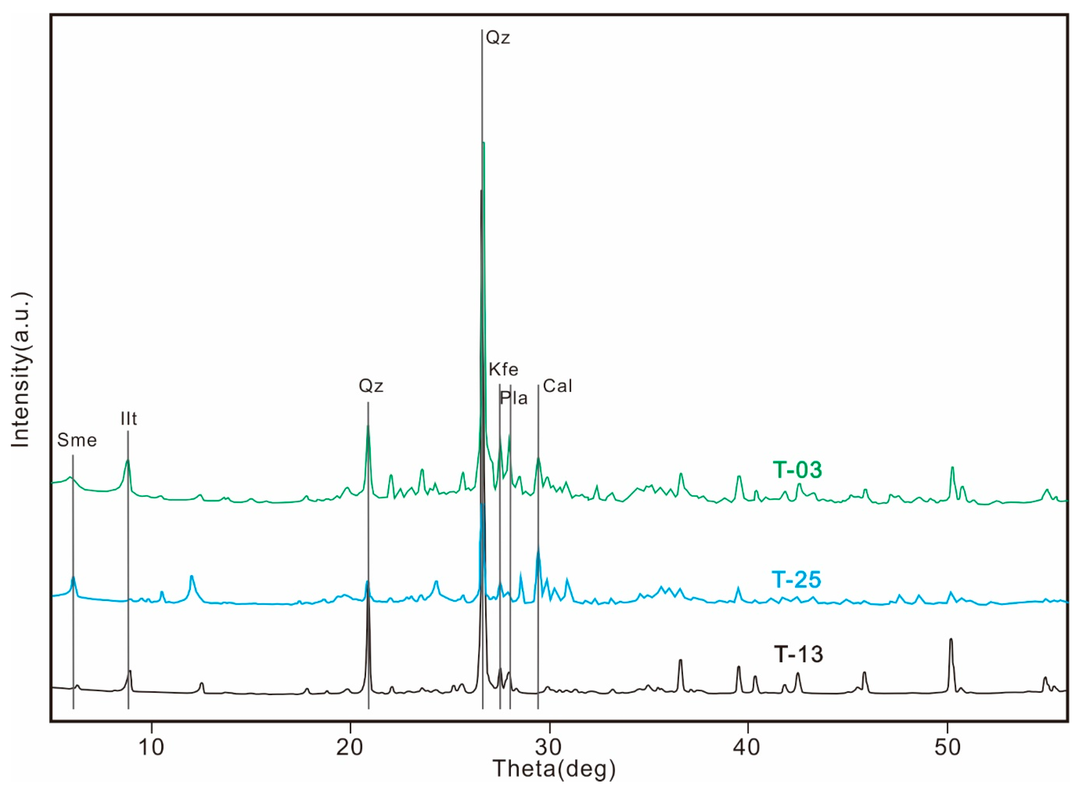
Figure 2 shows the full XRD patterns for the three soil samples selected from the soil samples, and the diagnostic peaks of the main minerals were marked. The minerals quartz, plagioclase, K-feldspar, illite, smectite, and calcite were the main components of the soils. The quartz, plagioclase, and K-feldspar were inactive in the NIR region because their Si–O fundamental vibrations were at 1030 cm−1. Concerning the other NIR active minerals, especially the carbonate minerals, the weak XRD peak near 30° indicated a minute quantity of calcite, and the NIR bands contained negligible carbonate influence. In this case, the NIR features of the soil samples must have been caused by the vibration of the O–H bond in the illite, smectite, or I/S mixed layers.

3.2. MIR Bands

The Si–O fundamental absorption bands were located at nearly 1000 cm−1 in the MIR spectra of this study, and the Si–O vibrational behavior did not form NIR spectra [25,26]. These bands were therefore not compared to NIR data in this research. The MIR spectra in two regions of the 28 samples are shown in Figure 3a,b.

3.2.1. Bands Ranging from 1500 to 4000 cm−1

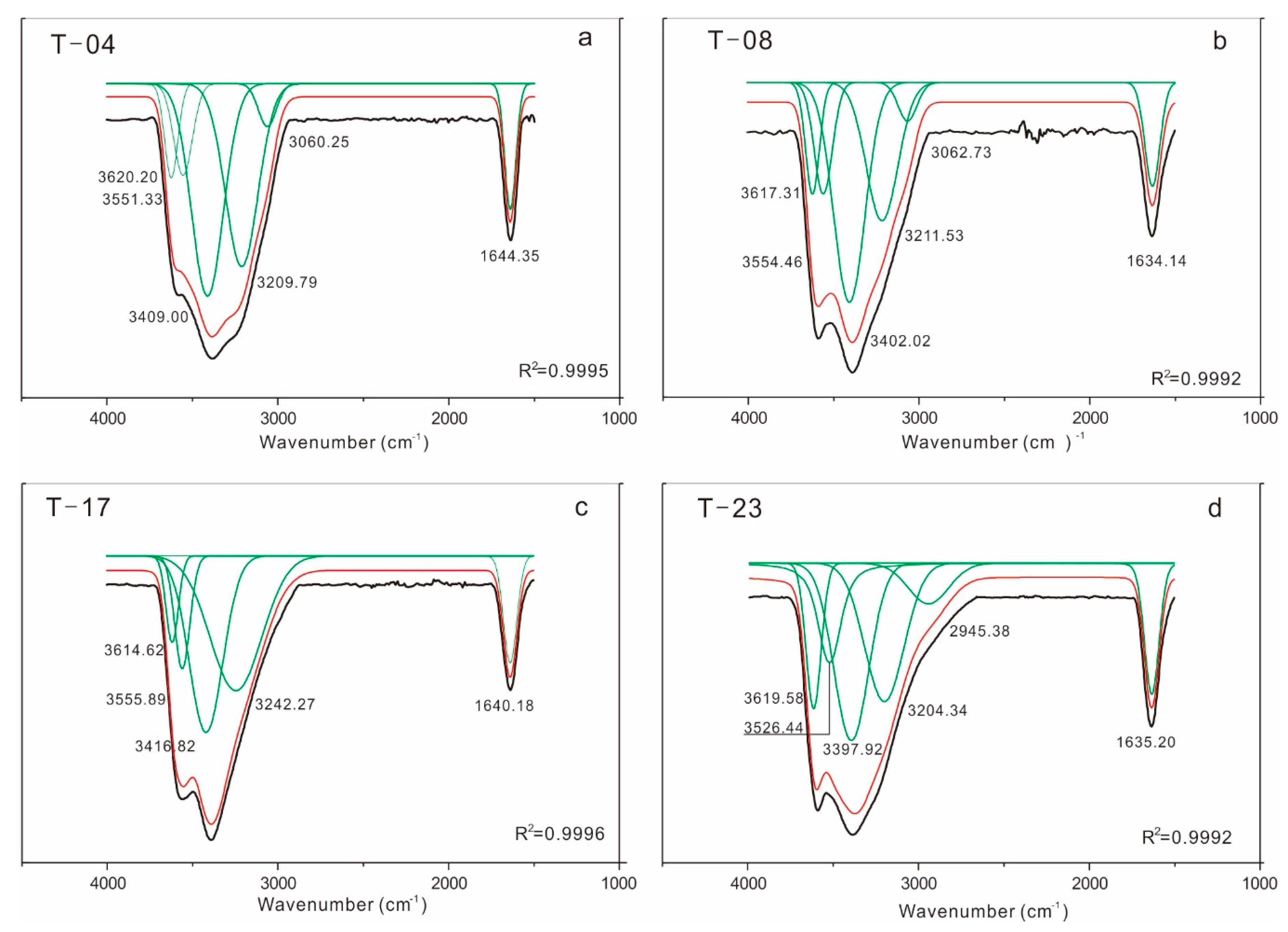
Figure 4 shows the MIR spectra ranging from 1500 to 4000 cm−1. Table 2 shows some assignments of illite–smectite minerals available in the literature in order to associate the vibration with the bands observed from the NIR spectra. A strong and sharp band near 1640 cm−1 was attributed to the OH deformation of water [27]. A relatively strong band was observed at 3625 cm-1 in the MIR region as well as in the spectra of kaolinite. This band was attributed to the stretching of OH groups in the 2:1 layer [28,29]. Furthermore, four wide absorptions that occurred between 3552 and 3052 cm−1 were also strong and overlapping in a large range of wavenumbers. The bands that occurred near 3625 cm−1 were assigned to the OH stretch in [AlAl]O–OH (ν[AlAl]O–OH); the bands at nearly 3552 cm−1 were assigned to the OH stretch in [AlFe]O–OH (ν[AlFe]O–OH); and the bands near 3377, 3238, and 3052 cm−1 were each interpreted as vibrational absorption of OH in H2O molecules [30,31]. Furthermore, Karapinar (2009) [32] observed that an increase of Cu content induced a shift of the bands near 3625 cm−1 toward a lower frequency.

3.2.2. Bands Ranging from 400 to 1500 cm−1

The MIR spectra of the 28 samples displayed an intense band at 1000 cm−1 (Figure 5 and Table 2). This band was caused by the Si–O stretch in the 2:1 layers [31,33] and could also occur in many phyllosilicates [27,34]. The second kind of absorption in this region was observed near 907, 870, and 786 cm−1. The bands near 907 and 870 cm−1 were assigned to the OH bending of [AlAl]O–OH and [AlFe]O–OH (δ[AlAl]O–OH and δ[AlFe]O–OH), and the band near 786 cm−1 was attributed to Si–O bending [33,35]. In the 400–700 cm−1 region, the MIR spectra displayed four bands near 645, 590, 525, and 460 cm-1, which were attributed to Si–O and Si–O [M3+oct] bending [31].

3.3. NIR Bands

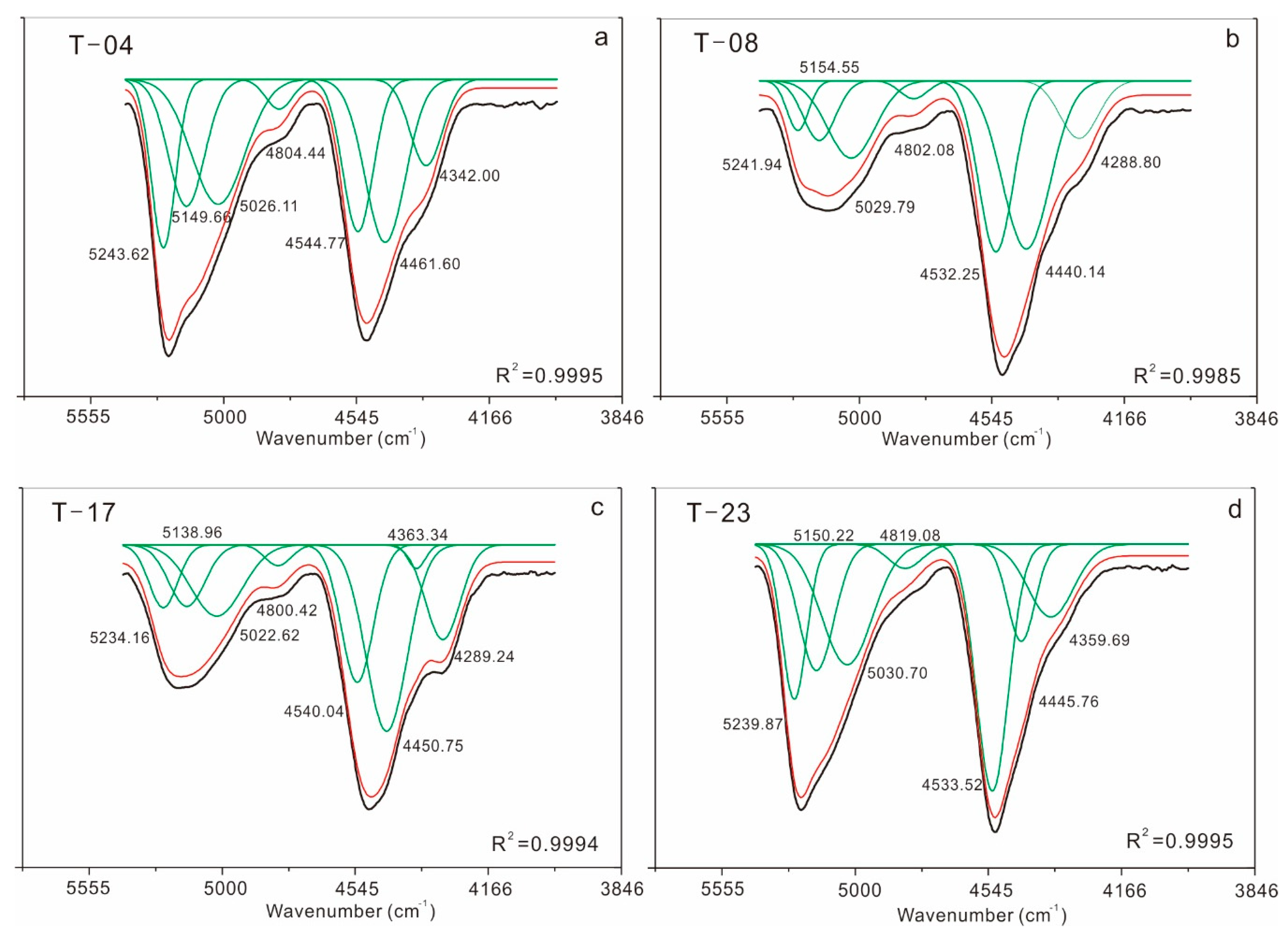
In most of the natural clay minerals, the combination bands (ν + δ)OH observed in the NIR spectra overlapped in a wide range of wavenumbers (Figure 3c). The results of the spectral component analysis showed at least three independent bands at nearly 5230, 5141, 5069, and 4803 cm−1 (1912, 1945, 1973, and 2082 nm), which were induced by the (ν + δ)water combination appearance [26]. The diagnostic peaks ranging from 4100 to 4700 cm−1, including bands near 4548, 4455, and 4325 cm−1, were the average band positions of all samples. The four typical samples (T-04, T-08, T-17, and T-23), including three independent absorption bands in this region, are shown in Figure 6. The strong bands near 4548, 4455, and 4325 cm−1 were ascribed to the combination of [AlAl]O–OH, [AlFe]O–OH, and H2O stretching and deformation vibrations in TOT layers [26], and this band was also observed in kaolinites at a similar frequency [36]. The absorptions in this range are intense and have been successfully used to detect smectite, illite, or I/S mixed layer minerals in remote sensing images [37,38]. The NIR absorption features at nearly 4548 cm−1 were compared with the MIR absorption features appearing at approximately 3625 and 907 cm−1. The band at nearly 4548 cm−1 was highly associated with the fundamental bands at 3625 and 907 cm−1, and positive linear correlations were determined between the NIR band and the MIR fundamental bands (Figure 7). The correlation result confirmed that the combination band in NIR spectra near 4548 cm−1 can be attributed to the combination of OH stretching (ν[AlAl]O–OH]) and bending (δ[AlAl]O–OH) vibration in the MIR spectra. Similar to the attribution of the 4548 cm−1 band, the absorption band at 4455 cm−1 was likely attributed to the fundamental bands at 3552 and 870 cm−1. Furthermore, the absorption band at 4325 cm-1 was attributed to the fundamental bands at 3477 and 786 cm−1.
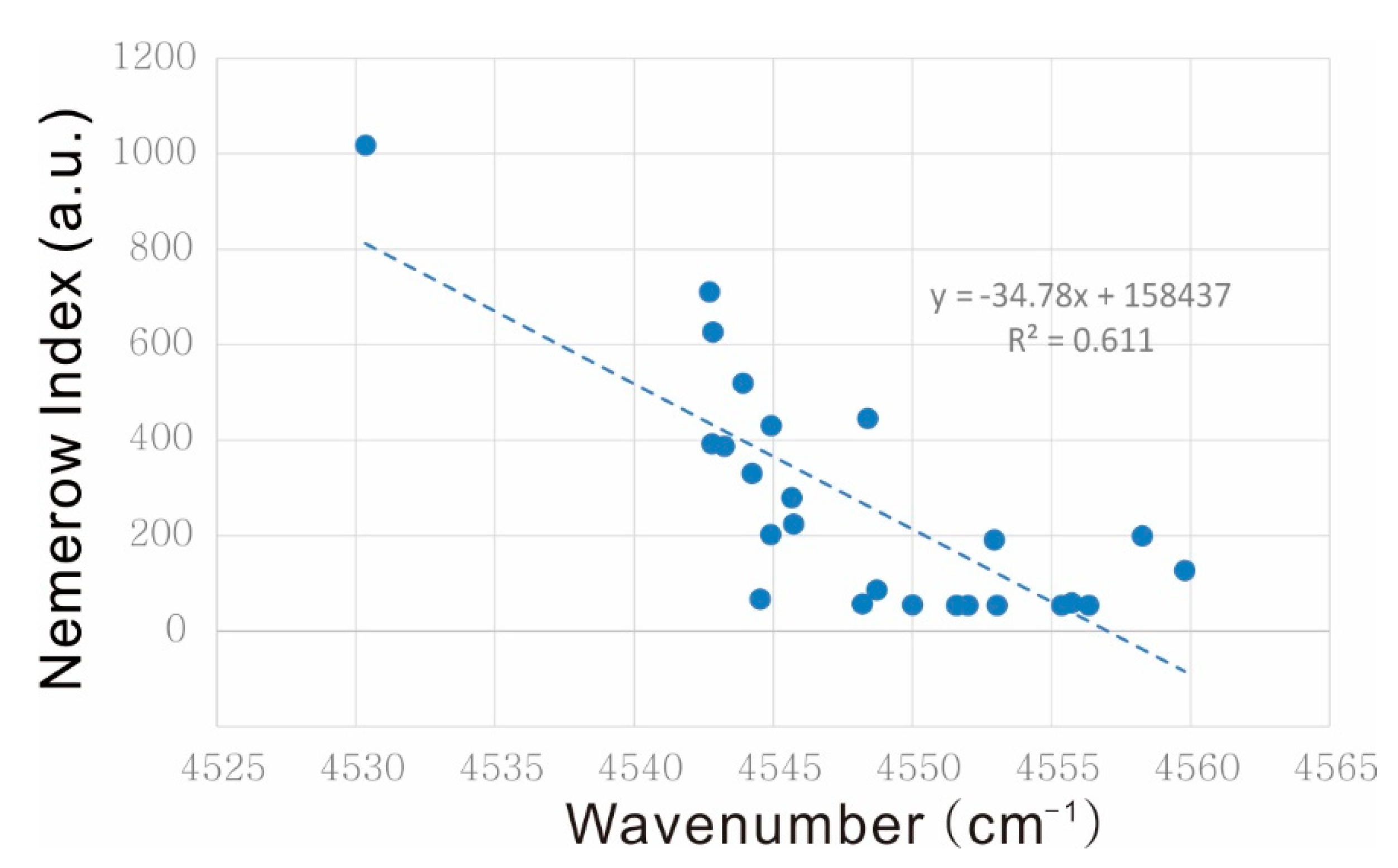
Across the entirety of the Nemerow index values, the combination bands of (ν + δ)OH shifted gradually from 4530.33 to 4559.88 cm−1. Figure 8 shows a linear correlation between the band position and the Nemerow index of the content of the six heavy metals for the 25 samples collected from the agricultural area in Tongguan County, and this relationship indicated that the absorptions observed near 4548 cm−1 shifted toward a higher frequency as the Nemerow Index of the six heavy metals decreased.
This correlation revealed that the adsorption of heavy metal cations would be the controlling factor in the positions of the NIR bands in the soils of loess areas [39]. In other words, the band positions of the diagnostic combination band near 4548 cm−1 or 2200 nm could be used to discriminate among soils containing illite, smectite, or I/S mixed layers with a variety of heavy metal contaminations. As Nemerow (1985) reported [20], soils with higher Nemerow index values (>3.0) would be seriously polluted, those with values between 2.0 and 3.0 would be moderately polluted, those with values between 1.0 and 2.0 would be mildly polluted, and those with values below 1.0 would be clean. Assuming that the absorption coefficients for the hydroxyl combination bands are associated with heavy metal cation adsorption in clay minerals, it is possible to distinguish between contaminated and clean soils using their hydroxyl band positions. The frequency of seriously polluted soils may occur at (ν + δ)[AlAl]O–OH absorption lower than 4552 cm−1; the frequency of moderately polluted soil (ν + δ)[AlAl]O–OH absorption should be from 4552 to 4554 cm−1; and the mildly polluted soil absorption position should higher than 4554 cm−1.
In this study, the multiple effects of the six kinds of heavy metals on NIR band positions were investigated by Partial Least Squares Regression (PLSR) analysis (Table 3). The results showed that a correlation existed between the NIR band positions near 4548 cm-1 and the six kinds of heavy metal cations ( R a d j 2 from 0.539 to 0.608). Although the six kinds of heavy metal cations were determined to be serious pollutants, the Cd content was the key factor in influencing the band position due to its high coefficient at −0.800066 in the established equation.

4. Discussion

The TOC content of the 28 samples ranged from 0% to 1.92% in the Tongguan loess soil area. The loess soil was arid, and the near-infrared spectral features of the organic matter were relatively weaker than the clay minerals. The soil pH values were between 7.55 and 8.66. This alkaline soil environment can stimulate the soil to adsorb more heavy metal ions.
Many previous studies on the mineral components of loess indicated that the main clay mineral is illite in the loess all over northwest China [40]. The XRD data in this study showed strong peaks of quartz, feldspar, and plagioclase. Among the clay minerals, the XRD data also showed relatively noticeable peaks of illite. Small amounts of smectite and calcite were revealed in the XRD data.
The NIR features of loess soils containing clay minerals with various heavy metal ions were studied, and a correlation between the fundamental vibrations in the MIR region (ν[AlAl]O–OH, δ[AlAl]O–OH) and the combination bands in the NIR region (ν + δ)[AlAl]O–OH was determined. The linear correlation indicated a simple way to identify which stretching and bending bands in the MIR region induce the combination bands in the NIR region in clay minerals that are widespread in loess soils. The findings demonstrate that these correlations can be used for any other soils containing some adsorptive minerals or organic matter, especially for OH-bearing minerals, carbonate minerals, and N–H organic materials.
Some considerable ambiguities existed when interpreting the number and positions of the spectral components in OH contents of some dioctahedral 2:1 clays. The water band overlaps with the structural OH features in high-frequency areas. Some available studies on the MIR spectra of smectites have reported that the water bands are overlapped by a band near 3410 cm−1, a shoulder band at 3255 cm−1 (overtone of water vibration at 1630 cm−1), and a narrow band at 3620 cm−1 [41,42,43]. In the present study, the molecular water features of MIR were two broad bands approximated at 3224 and 3433 cm−1.
Qualitatively speaking, the occurrence frequencies of the stretching bands related to various cation environments of OH groups in the MIR spectra of smectites have similar regularities as 2:1 micas [44]. On one hand, for cations with the same or similar atomic masses, the total valences of the cations and the wavenumbers of the corresponding band have a positive relationship; on the other hand, with a constant total valence of the OH group, there is a negative relationship between the sum of the cation masses and the wavenumbers of the corresponding band. However, there are certain distinctions between the number and frequencies of the individual metal OH bands in the spectra of soils with smectite, illite, and I/S mixed layer minerals.
Some previous studies of clay minerals have shown that the MIR band positions of structural OH bonds in smectites generally have more shifted wavenumbers than illites. This is due to the different orientation of the OH vector. In illites, the OH vector is tilted toward the vacant octahedron and forms a small angle with the ab plane (15°–0° from muscovite to celadonite), and this is caused by the repulsion between the hydroxyl proton and the interlayer cation. This phenomenon could further influence the hydrogen bonds containing a proton and two apical oxygen atoms in the octahedral sheet and weaken the bond within the OH group [44]. Smectite has strong adsorptivity in capturing cations in its interlayer, and the interlayer cation and residual H2O molecule usually occupy the ditrigonal cavity in the tetrahedral sheet. Therefore, owing to the low occupation of interlayer cations, a large angle is formed between the OH carrier and the ab surface. Furthermore, it relatively strengthens the OH bond and leads to a band shift toward higher wavenumbers for individual OH stretching bands [44]. In this study, the soil samples from the loess area containing a variety of minerals and clays were the dominant factors for NIR features. The OH combination bands were overlapped by the absorption features of illite and smectite. Similar to the band shift mechanism of the MIR bands, the OH bands from both illite and smectite appeared to have an identical relationship with the individual heavy metal cations as well as the Nemerow index. The correlation coefficient was not perfect in this study between the NIR band positions and the Nemerow index. This is because only a part of the heavy metal cations directly influenced the band positions. Some studies on the form of occurrence of heavy metal elements in soils indicated there are five forms: exchangeable, bound to carbonate and specifically adsorbed, bound to Fe–Mn oxides, bound to organic matter and sulfide, and a residual phase [45]. It remains unclear which kinds of heavy metals are the key influencing factors for the MIR and NIR absorption features. Further investigation will be needed to determine the influencing factors in order to provide a deeper insight into the band shift mechanism.
The multiple PLSR correlation showed in Table 3 proved that heavy metal pollution in loess soils can influence the NIR band positions. Furthermore, the simple linear correlation between the positions of OH combination bands and the Nemerow index provided a method for linking the soil pollution level and the NIR spectral band positions. In contrast to MIR or Raman spectroscopy, NIR spectroscopy is an in situ and on-line technique for detecting the hydroxyl group environment. The results of the NIR spectra in estimating heavy-metal-polluted soils with clay minerals have shown its efficient advantage. Nevertheless, the whole interpretation of the diagnostic peaks still needs further improvement and complementary studies with the aid of a rigorous mathematical model. However, this method would require considerable knowledge about the behaviors of the heavy metal elements in the soils. Thus, the correlation found in this study can be tentatively applied to monitor soils with pollution risks in the loess area in northwest China.

5. Conclusions

This study confirmed the assignment of NIR bands in loess soils with abundant clay minerals, and the key factors of NIR spectra were achieved by comparing them with MIR absorption features and the Nemerow index. The relationship between NIR band positions and the Nemerow index shows a potential approach for investigating the degree of heavy metal pollution in loess areas. Two main conclusions can be drawn on the basis of the NIR spectroscopy:
(a)
The loess soils featured NIR absorption near 4548 cm−1 (2200 nm); this is attributed to the combination of OH stretching and bending in the [AlAl]O–OH group in the MIR spectra.
(b)
The positions of the NIR absorption features revealed a negative correlation with the Nemerow index. The NIR absorption features of seriously polluted soils will occur in frequencies less than 4552 cm−1, and the NIR absorption features of mildly polluted soils will occur at positions higher than 4554 cm−1.
The discrimination of heavy-metal-contaminated soils in loess areas via NIR spectra is very important for tracing heavy metal elements by remotely sensed hyperspectral images and field spectral surveys. Spectral interpretation with hyperspectral data or field spectral data is prevailingly applied to distinguish structural and compositional variations within clay minerals, which is a significant factor, as the mineral composition or structure may systematically vary in a certain weathering environment as a function of the pH and composition of the water leaching. Mapping ionic clays and analyzing their relations with heavy metal elements adsorbed in soils can allow remote sensing researchers and environmentalists to locate potentially polluted soils within some adsorptive minerals [46,47,48]. Accurate interpretations of NIR spectra will contribute to fast or on-line analysis of phyllosilicates and to a better understanding of the environmental questions reflected by remote sensing images.

Author Contributions

Conceptualization, M.Y. and Y.X.; Nemerow methodology, J.Z.; NIR analysis, M.Y.; pH and TOC analysis, H.C.; MIR analysis, S.L.; ICP-MS and pH analysis, W.L.; XRD analysis, Y.H.; writing—review and editing, M.Y.; project administration, M.Y.and Y.X. All authors have read and agreed to the published version of the manuscript. please turn to the CRediT taxonomy for the term explanation. Authorship must be limited to those who have contributed substantially to the work reported.

Funding

This research was funded by the National Natural Science Foundation of China, grant number 41502312, the China Geological Survey Foundation, grant numbers DD20190078, DD20160336 and DD20160002.

Acknowledgments

We are thankful to the Instrumental Analysis Center of Xi’an Jiaotong University, the Key Laboratory for Geohazards in Loess Areas, the Chinese Ministry of Natural Resources, and the Xi’an Center of China Geological Survey for their contributions to this research. The authors would like to thank the reviewers for their very helpful and constructive reviews of this manuscript.

Conflicts of Interest

The authors declare no conflict of interest.

References

  1. Huang, C.; Xu, J. Edaphology, 3rd ed.; China Agriculture Press: Beijing, China, 2010; pp. 1–10. [Google Scholar]
  2. Xu, Y.; Yuan, H.; He, F.; Chen, S.; Zhang, J. Problems of sustainable development on mine exploitation in northwest China. Resour. Ind. 2003, 5, 53–55. (In Chinese) [Google Scholar]
  3. Zhao, A.; Wang, J.; Chen, H.; Zhang, J. Environmental Problems and Countermeasures for Sustainable Development in a Declining Mining City Tongchuan. Advances in Social Science, Education and Humanities Research. In Proceedings of the 8th International Conference on Education, Management, Information and Management Society (EMIM 2018), Shenyang, China, 28–30 June 2018. [Google Scholar] [CrossRef]
  4. Gong, S.; Wang, X.; Shen, R.; Liu, Z.; Li, Y. Study on heavy metal element content in the coastal saline soil by hyperspectral remote sensing. Remote Sens. Technol. Appl. 2010, 25, 169–177. (In Chinese) [Google Scholar]
  5. Malley, D.F.; Williams, P.C. Use of Near-infrared reflectance spectroscopy in Prediction of heavy metals in freshwater sediment by their association with organic matter. Evniron. Sci. Technol. 1997, 31, 3461–3467. [Google Scholar] [CrossRef]
  6. Chang, C.; Laird, D.; Mausbach, M.J.; Hurburgh, C.R. Near-Infrared Reflectance Spectroscopy-Principal Components Regression Analyses of Soil Properties. Agric. Biosyst. Eng. 2001, 65, 480–490. [Google Scholar] [CrossRef] [Green Version]
  7. Kemper, T.; Sommer, S. Estimate of heavy metal contamination in soils after a mining accident using reflectance spectroscopy. Environ. Sci. Technol. 2002, 36, 2742–2747. [Google Scholar] [CrossRef]
  8. Sun, W.; Zhang, X. Estimating soil Zn concentrations using reflectance spectroscopy. Int. J. Appl. Earth Obs. Geoinf. 2017, 58, 126–133. [Google Scholar] [CrossRef]
  9. Gholizadeh, A.; Boruvka, L.; Saberioon, M.M.; Kozak, J.; Vasat, R.; Nemecek, K. Comparing Different Data Preprocessing Methods for Monitoring Soil Heavy Metals Based on Soil Spectral Features. Soil Water Res. 2015, 10, 218–227. [Google Scholar] [CrossRef] [Green Version]
  10. Kalm, V.E.; Rutter, N.W.; Rokosh, C.D. Clay minerals and their paleoenvironmental interpretation in Baoji loess section, Southern Loess Plateau, China. Catena 1996, 27, 49–61. [Google Scholar] [CrossRef]
  11. Srasra, E.; Bergaya, F.; Fripiat, J.J. Infrared spectroscopy study of tetrahedral and octahedral substitutions in an interstratified illite-smectite clay. Clays Clay Miner. 1994, 42, 237–241. [Google Scholar] [CrossRef]
  12. Post, J.L.; Borer, L. Physical properties of selected illites, beidellites and mixed-layer illite–beidellites from southwestern Idaho, and their infrared spectra. Appl. Clay Sci. 2002, 22, 77–91. [Google Scholar] [CrossRef]
  13. Eren, E.; Afsin, B. An investigation of Cu (II) adsorption by raw and acid-activated bentonite: A combined potentiometric, thermodynamic, XRD, IR, DTA study. J. Hazard. Mater. 2008, 151, 682–691. [Google Scholar] [CrossRef] [PubMed]
  14. Post, J.L.; Noble, P.N. The near-infrared combination band frequencies of dioctahedral smectites, micas, and illites. Clays Clay Miner. 1994, 41, 639–644. [Google Scholar] [CrossRef]
  15. Rathod, P.H.; Freek, I.M.; Van der Meer, F.D. Analysis of visible and near infrared spectral reflectance for assessing metals in soil. Evniron. Monit. Assess. 2016, 188, 558. [Google Scholar] [CrossRef]
  16. Wu, H.; Wu, G.; Ren, Y.; Yang, L.; Wang, L.; Li, X. Co2+/Co3+ ratio dependence of electromagnetic wave absorption in hierarchical NiCo2O4-CoNiO2 hybrids. J. Mater. Chem. C 2015, 29, 7677–7690. [Google Scholar] [CrossRef]
  17. Wu, H.; Wu, G.; Wang, L. Peculiar porous α-Fe2O3, γ-Fe2O3 and Fe3O4 nanospheres: Facile synthesis and electromagnetic properties. Powder Technol. 2015, 269, 443–451. [Google Scholar] [CrossRef]
  18. Brugge, C.J.; Stiegman, A.E.; Rainen, R.A.; Springsteen, A.W. Use of spectralon as a diffuse reflectance standard for in-flight calibration of Earth-orbiting sensors. Opt. Eng. 1993, 32, 805–814. [Google Scholar] [CrossRef]
  19. Clark, R.N.; Swayze, G.A.; Livo, K.E.; Kokaly, R.F.; King, T.V.V.; Dalton, J.B.; Vance, J.S.; Rockwell, B.W.; Hoefen, T.; McDougal, R.R. Surface reflectance calibration of terrestrial imaging spectroscopy data: A tutorial using AVIRIS. In Proceedings of the 10th Airborne Earth Science Workshop, Pasadena, CA, USA, 4–8 March 2002; p. 474. [Google Scholar]
  20. Nemerow, N.L. Stream, Lake, Estuary, and Ocean Pollution; Van Nostrand Reinhold: New York, NY, USA, 1985. [Google Scholar]
  21. Liu, X.; Heilig, G.K.; Chen, J.; Heino, M. Interactions Between Economic Growth and Environmental Quality in Shenzhen, China’s First Special Economic Zone; International Institute for Applied Systems: Laxenburg, Austria, 2006. [Google Scholar]
  22. Sunshine, J.M.; Pieters, C.M. Determing the composition of olivine from reflectance spectroscopy. J. Geophys. Res. 1998, 103, 675–688. [Google Scholar] [CrossRef]
  23. Sundius, T. Computer fitting of Voigt profiles to Raman lines. J. Raman Spectrosc. 1973, 1, 471–488. [Google Scholar] [CrossRef]
  24. Sherwood, P.M.A. Rapid evaluation of the Voigt function and its use for interpreting X-ray photoelectron spectroscopic data. Surf. Interface Anal. 2019, 51, 254–274. [Google Scholar] [CrossRef]
  25. McKeown, D.A.; Bell, M.I.; Etz, E.S. Vibrational analysis of the dioctahedral mica: 2M1 muscovite. Am. Mineral. 1999, 84, 1041–1048. [Google Scholar] [CrossRef]
  26. Madejova, J.; Pentrak, M.; Palkova, H.; Komadel, P. Near-infrared spectroscopy: A powerful tool in studies of acid-treated clay minerals. Vib. Spectrosc. 2009, 49, 211–218. [Google Scholar] [CrossRef]
  27. Madejova, J.; Komadel, P. Baseline study of the clay minerals society source clays: Infrared methods. Clays Clay Miner. 2001, 49, 410–432. [Google Scholar] [CrossRef]
  28. Hayashi, H.; Oinuma, K. Relationship between infrared absorption spectra in the region of 450-900 cm-1 and chemical composition of chlorite. Am. Mineral. 1965, 50, 476–483. [Google Scholar]
  29. Prieto, A.C.; Lobón, J.M.; Alia, J.M.; Rull, F.; Martin, F. Thermal and spectroscopic analysis of natural trioctahedral chlorites. J. Therm. Anal. 1991, 37, 969–981. [Google Scholar] [CrossRef]
  30. Shirozu, H. Cation distribution, sheet thickness, and O-OH space in trioctahedral chlorites-An X-ray and infrared study. Miner. J. 1980, 10, 14–34. [Google Scholar] [CrossRef] [Green Version]
  31. Prieto, A.C.; Dubessy, J.; Cathelineau, M. Structure composition relationships in trioctahedral chlorites: A vibrational spectroscopy study. Clays Clay Miner. 1991, 39, 531–539. [Google Scholar] [CrossRef]
  32. Karapinar, N.; Donat, R. Adsorption behavior of Cu2+ and Cd2+ onto natural bentonite. Desalination 2009, 249, 123–129. [Google Scholar] [CrossRef]
  33. Yang, M.; Ren, G.; Gao, T.; Li, J.; Qiu, D.; Yi, H.; Han, H. Uses of near-infrared spectra for the identification of calcite and dolomite in carbonate rocks. J. Comput. Theor. Nanos. 2015, 12, 5854–5858. [Google Scholar] [CrossRef]
  34. Kloprogge, J.T.; Frost, R.L.; Rintoul, L. Single crystal raman microscopic study of the asbestos mineral chrysotile. Phys. Chem. Chem. Phys. 1999, 1, 2559–2564. [Google Scholar] [CrossRef]
  35. Kloprogge, J.T.; Frost, R.L. Thermal decomposition of ferrian chamosite: An infrared emission spectroscopic study. Contrib. Mineral Petrol. 2000, 138, 59–67. [Google Scholar] [CrossRef]
  36. Petit, S.; Madejová, J.; Decarreau, A.; Martin, E. Characterization of octahedral substitutions in kaolinites using near-infrared spectroscopy. Clays Clay Miner 1999, 47, 103–108. [Google Scholar] [CrossRef]
  37. Meer, F.D.; Werff, H.M.A.; Ruitenbeek, F.J.A.; Hecker, C.A.; Bakker, W.H.; Moomen, M.F.; Meijde, M.; Carranza, E.J.M.; Smeth, J.B.; Woldai, T. Multi- and hyperspectral geologic remote sensing: A review. Int. J. Appl. Earth Obs. 2012, 14, 112–128. [Google Scholar] [CrossRef]
  38. Pour, A.B.; Hashim, M. Hydrothermal alteration mapping from Landsat-8 data, Sar Cheshmeh copper mining district, south-eastern Islamic Republic of Iran. J. Taibah Univ. Sci. 2015, 121, 1658–3655. [Google Scholar] [CrossRef]
  39. Guggenheim, S.; Adams, J.M.; Bain, D.C.; Bergaya, F.; Brigatti, M.F.; Drits, V.A.; Formoso, M.L.L.; Galan, E.; Kogure, T.; Stanjek, H. Summary of recommendations of nomenclature committess relevant to clay mineralogy: Report of the Association Internationale pour l’Etude des Argiles (AIPEA) Nomenclature Committee for 2006. Clay Miner. 2006, 41, 863–877. [Google Scholar] [CrossRef]
  40. Bronger, A.; Heinkele, T. Mineralogical and clay mineralogical aspects of loess research. Quat. Int. 1990, 7, 37–52. [Google Scholar] [CrossRef]
  41. Farmer, V.C. (Ed.) The Layer Silicates: Infrared Spectra of Minerals; Monograph 4; Mineralogical Society: London, UK, 1974; pp. 331–363. [Google Scholar]
  42. Madejova, J.; Komadel, P.; Cicel, B. Infrared study of octahedral site populations in smectites. Clay Miner. 1994, 29, 319–326. [Google Scholar] [CrossRef]
  43. Besson, G.; Drits, V.A. Refined relationships between chemical composition of dioctahedral fine-dispersed mica minerals and their infrared spectra in the OH stretching region. Part I. Identification of the stretching bands. Clays Clay Miner. 1997, 45, 158–169. [Google Scholar] [CrossRef]
  44. Besson, G.; Drits, V.A. Refined relationship between chemical composition of dioctahedral fine-dispersed mica minerals and their infrared spectra in the OH stretching region. Part II. The main factors affecting OH vibration and quantitative analysis. Clays Clay Miner. 1997, 45, 170–183. [Google Scholar] [CrossRef]
  45. Li, X.; Poon, C.; Liu, P. Heavy metal contamination of urban soils and street dusts in Hong Kong. Appl. Geochem. 2001, 16, 1361–1368. [Google Scholar] [CrossRef]
  46. Duke, E.F. Near-infrared spectra of muscovite, Tschermak substitution, and metamorphic reaction progress: Implications for remote sensing. Geology 1994, 22, 621–624. [Google Scholar] [CrossRef]
  47. Young, S.S.; Moon, K.K.; Wang, J.Y. Pyrophyllite mapping in the Nohwa deposit, Korea, using ASTER remote sensing data. Geosci. J. 2014, 18, 295–305. [Google Scholar]
  48. Laakso, K.; Peter, J.M.; Rivard, B.; White, H.P. Short-wave infrared spectral and geochemical characteristics of hydrothermal alteration at the Archean Izok lake Zn-Cu-Pb-Ag volcanogenic massive sulfide deposit, Numavut, Canada: Application in exploration target vectoring. Econ. Geol. 2016, 111, 1223–1239. [Google Scholar] [CrossRef]
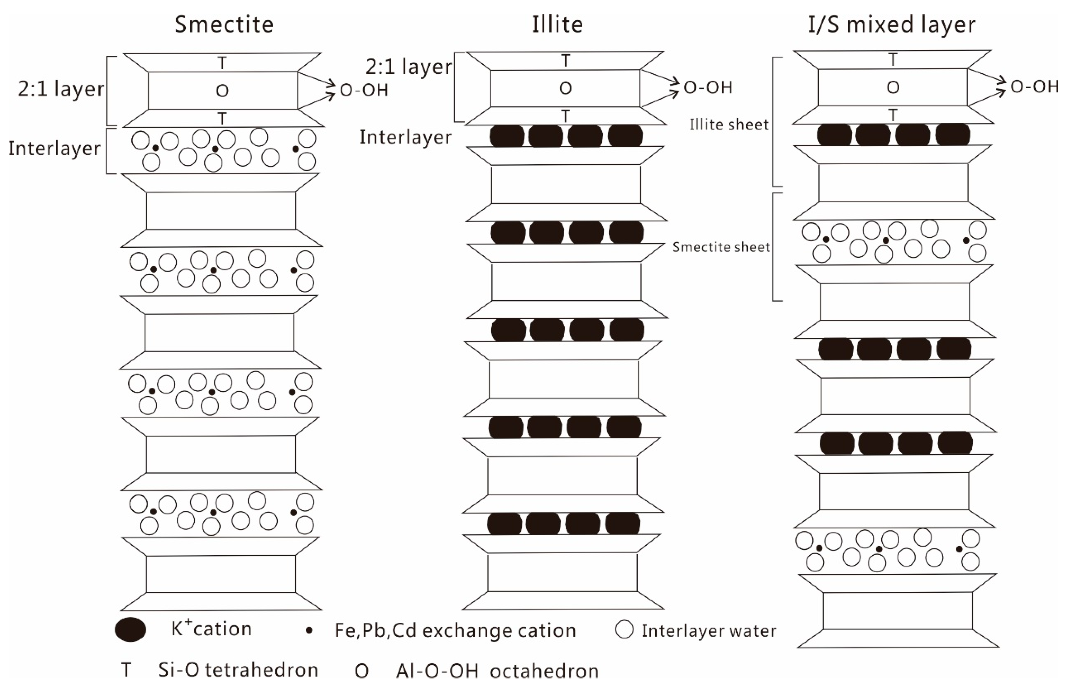
Figure 1. The structure of smectite, illite, and I/S mixed layer.
Minerals 10 00089 g001
Figure 2. XRD spectra of three selected samples. Sme: smectite, Ilt: illite, Qz: quartz, Kfe: K-feldspar, Pla: plagioclase, and Cal: calcite.
Minerals 10 00089 g002
Figure 3. The MIR and NIR spectra of the soil samples: (a) shows the MIR spectra from 4000 to 1500 cm-1, (b) shows the MIR spectra from 400 to 1500 cm-1, and (c) shows the NIR spectra from 5405 to 4000 cm-1.
Minerals 10 00089 g003
Figure 4. Decomposition of the MIR bands in the high-frequency area of four samples (a) T-04, (b) T-08, (c) T-17, and (d) T-23. Black lines: experimental spectra; green lines: individual bands; red lines: fitted curves.
Minerals 10 00089 g004
Figure 5. Decomposition of the MIR bands in the low-frequency area of four samples (a) T-04, (b) T-08, (c) T-17, and (d) T-23. Black line: experimental; green line: fit and diagnostic bands.
Minerals 10 00089 g005
Figure 6. Decomposition of the NIR combination bands of four samples (a) T-04, (b) T-08, (c) T-17, and (d) T-23. Black line: experimental; green line: fit and diagnostic bands.
Minerals 10 00089 g006
Figure 7. Linear correlation between NIR absorption bands and MIR ((a) shows MIR bands near 907 cm−1, (b) shows MIR bands near 3625 cm−1) absorption bands.
Minerals 10 00089 g007
Figure 8. Linear correlation between diagnostic NIR bands and Nemerow index value.
Minerals 10 00089 g008
Table 1. The pH values, TOC values, and Nemerow index of the 28 samples.
IDpHTOCNemerow Index
Wt. %
T-018.021.28658.47
T-028.171.491107.24
T-037.951.24790.48
T-048.400.41536.04
T-058.280.77389.52
T-067.801.92260.39
T-077.981.52168.40
T-087.890.45159.58
T-097.860.76319.05
T-107.640.64450.92
T-118.211.17197.80
T-128.160.21433.49
T-138.420.18209.66
T-148.110.20172.37
T-157.980.00384.50
T-169.851.6686.03
T-178.201.5517.46
T-187.870.08754.80
T-198.281.072.99
T-208.290.712.72
T-218.660.951.97
T-228.291.182.24
T-238.261.672.31
T-248.420.985.56
T-258.640.9248.42
T-268.430.987.81
T-277.550.742.70
T-288.440.9838.36
Table 2. Assignment of the MIR absorptions in former studies.
Absorptions (cm−1) Studied by Madejova (2001)Assignment
3689, 3694, 3669, 3651OH stretching of inner-surface hydroxyl groups
3620OH stretching of [AlAl]O–OH
3586OH stretching of [AlFe]O–OH
3457OH stretching of water
1635OH bending of water
1115Si–O stretching
1033Si–O stretching
912, 915OH bending of [AlAl]O–OH
885OH bending of [AlFe]O–OH
755Si–O bending
645Si–O bending
541Al–O–Si bending
472Si–O–Si bending
432Si–O bending
Table 3. Display of multiple PLSR correlation between heavy metal contents and NIR band positions near 4548 cm−1.
VariablesParametersLatent Factors
123456
Cu0.0082990.4650.6160.6110.6110.6150.615
Pb−0.0035501.2421.2081.2061.2061.2061.206
Zn−0.0003171.0791.0311.0321.0321.0311.031
Cr0.0482720.0820.4160.4220.4240.4240.424
Cd−0.8000661.0761.0211.0141.0161.0201.020
Mo−0.0194711.3831.3831.3901.3891.3881.388
Constants / R a d j 2 4549.7116350.5390.6080.6020.5860.5680.548