
A Multi-Objective Approach for Optimizing the Layout of Additional Boreholes in Mineral Exploration


Abstract
:1. Introduction
2. Case Study: Eastern Kahang Deposit
Deposit
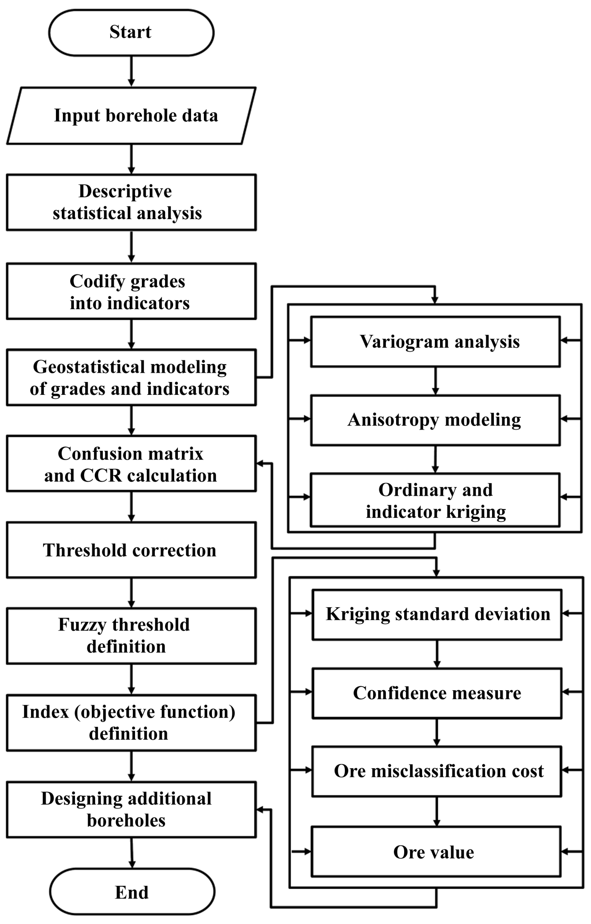
3. Methodology
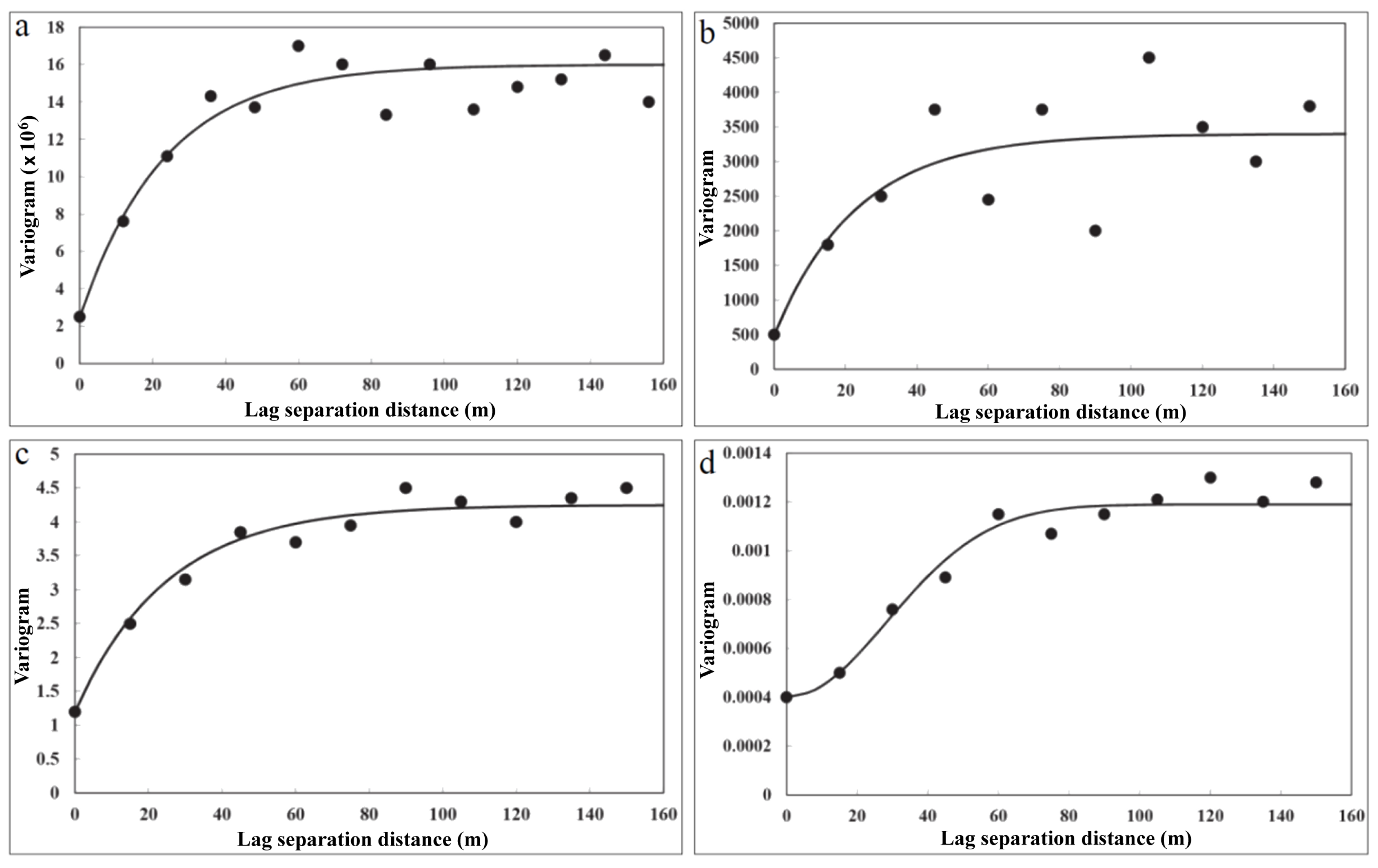
3.1. Directional Variogram Analysis
3.2. Spatial Anisotropy Modeling
3.3. Ordinary Kriging
3.4. Indicator Kriging
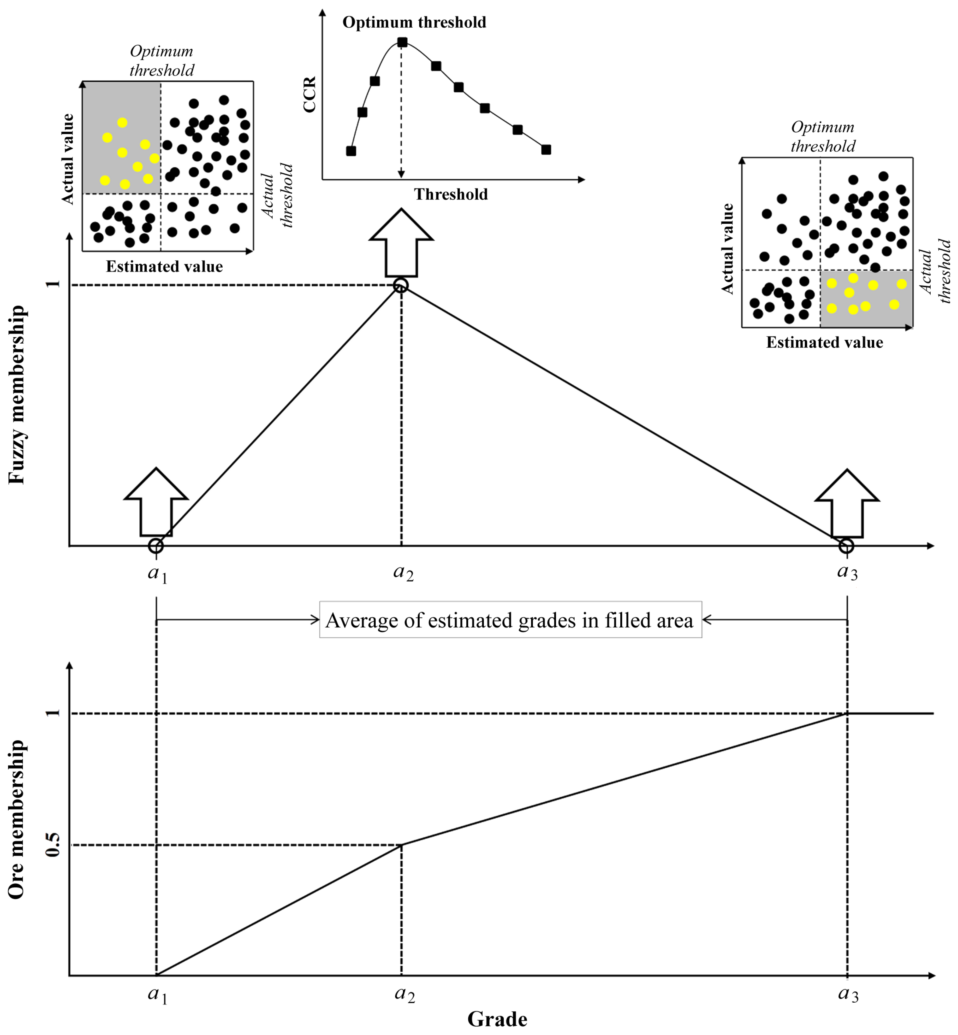
3.5. Introducing Fuzzy Thresholds and the Ore Membership Degree
3.6. Ore Value Modeling
3.7. Misclassification Cost
3.8. Our Proposal: Multi-Objective Function Index
- maximize the kriging standard deviation (KSD), reflecting a high uncertainty in the true unknown grades;
- minimize confidence measure (CM), reflecting a high uncertainty in the ore-waste classification;
- maximize ore value (OV), reflecting a high potential economic value;
- maximize misclassification cost (MC), reflecting a high impact of ore loss and waste dilution.
4. Results and Discussion
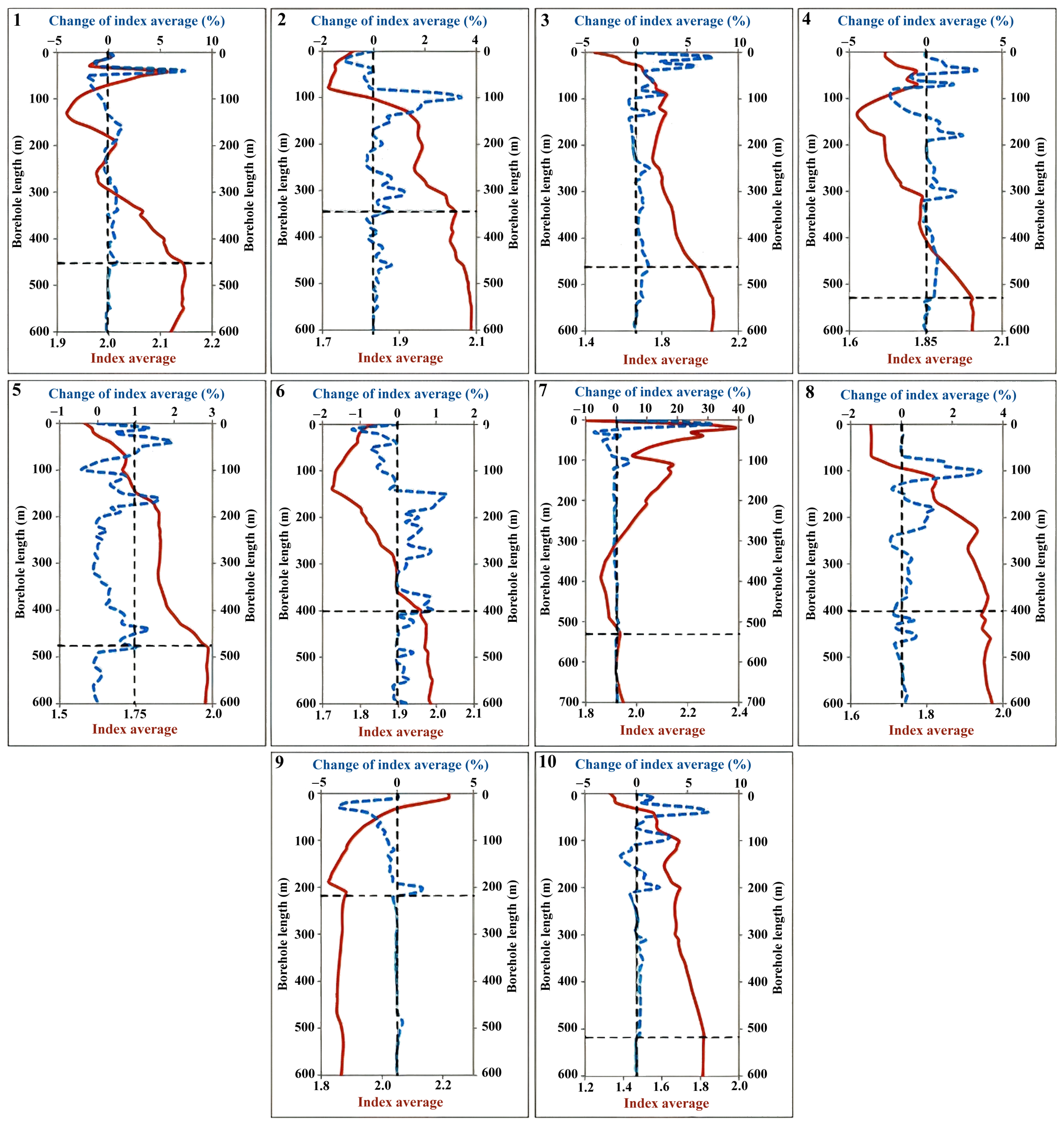
4.1. Application of the Index to Define Additional Boreholes
4.2. Discussion
5. Conclusions
- The average kriging standard deviation quantifies the uncertainty in the true grades and was obtained based on ordinary kriging results.
- The confidence measure expresses the certainty of the decision to assign blocks to the ore or waste classes. This measure was calculated by a discrimination rate between ore and waste probabilities, which were obtained based on indicator kriging results.
- Fuzzy thresholds were recommended instead of a sharp threshold. The actual and kriging estimated grades were classified to calculate a confusion matrix and correct classification rate (CCR), which were applied to define fuzzy thresholds for Cu, Mo, Ag, and Au. The center of the triangular fuzzy number (TFN) was determined by maximizing CCR, and the lower and upper limits of the TFN were determined by the average of estimated grades in the false positive (FP) and false negative (FN) categories, respectively. The TFNs of Cu, Mo, Ag, and Au were obtained as ; ; ; and . The ore membership function was then modeled by a quasi-trapezoidal membership function based on the TFN center and limits.
- The ore value function represents the total value of each block by calculating the sum of a weight factor times the ore membership degree times the estimated grade for all the ore elements. It measures the economic potential of the block.
- The misclassification cost includes the ore loss and dilution economic impact computed by the income lost when sending ore to the dump and the extra cost of mining and processing waste material.
- An index for the selection of additional boreholes was finally defined by multiplying the kriging standard deviation, ore value, and misclassification cost and dividing by the confidence measure. By surveying the index average and its change along the axis of the additional boreholes, the properties of eight vertical and two directional additional boreholes were proposed together with their priorities.
Author Contributions
Funding
Data Availability Statement
Acknowledgments
Conflicts of Interest
References
- Bengough, A.G.; Castrignano, A.; Pages, L.; Noordwijk, M. Sampling strategies, scaling and statistics. In Root Methods; Smit, A.L., Bengough, A.G., Engels, C., Noordwijk, M., Pellerin, S., Geijn, S.C., Eds.; Springer: Berlin, Germany, 2000; pp. 147–173. [Google Scholar]
- Bilisoly, R.L.; McKenna, S.A. Determining Optimal Location and Numbers of Sample Transects for Characterization of UXO Sites; SAND Report SAND2002-3962; Sandia National Laboratories: Albuquerque, NM, USA, 2003; 47p.
- Vanem, E.; Gramstad, O.; Bitner-Gregersen, E.M. A simulation study on the uncertainty of environmental contours due to sampling variability for different estimation methods. Appl. Ocean Res. 2019, 91, 101870. [Google Scholar] [CrossRef]
- Lin, Y.P.; Yeh, M.S.; Deng, D.P.; Wang, Y.C. Geostatistical approaches and optimal additional sampling schemes for spatial patterns and future sampling of bird diversity. Glob. Ecol. Biogeogr. 2008, 17, 175–188. [Google Scholar] [CrossRef]
- Rossi, M.E.; Deutsch, C.V. Mineral Resource Estimation; Springer: Dordrecht, The Netherlands, 2014; pp. 1–332. [Google Scholar]
- Knödel, K.; Lange, G.; Voigt, H.J. Environmental Geology: Handbook of Field Methods and Case Studies; Springer: Berlin, Germany, 2007; pp. 1–1357. [Google Scholar]
- Emery, X.; Séguret, S.A. Geostatistics for the Mining Industry—Applications to Porphyry Copper Deposits; CRC Press: Boca Raton, FL, USA, 2020; pp. 1–247. [Google Scholar]
- Savinskii, J.D. Probability Tables for Locating Elliptical Underground Masses with a Rectangular Grid; Springer: New York, NY, USA, 1965; 110p. [Google Scholar]
- Singer, D.A.; Wickman, F.E. Probability Tables for Locating Elliptical Targets with Square, Rectangular, and Hexagonal Point-Nets; The Pennsylvania State University: State College, PA, USA, 1969; 100p. [Google Scholar]
- Hossein Morshedy, A.; Memarian, H. A novel algorithm for designing the layout of additional boreholes. Ore Geol. Rev. 2015, 67, 34–42. [Google Scholar] [CrossRef]
- Colombera, L.; Mountney, N.P.; Russell, C.E.; Shiers, M.N.; McCaffrey, W.D. Geometry and compartmentalization of fluvial meander-belt reservoirs at the bar-form scale: Quantitative insight from outcrop, modern and subsurface analogues. Mar. Pet. Geol. 2017, 82, 35–55. [Google Scholar] [CrossRef]
- Oh, I.H.; Yang, S.J.; Heo, C.H.; Lee, C.; Jin, K.; Lee, J.H.; Jets, S. Applying three-dimensional modeling based on trench surveys to chromitite orebodies in the BophiVum area, northwestern Myanmar. Geosci. J. 2021, 25, 333–349. [Google Scholar] [CrossRef]
- Drew, L.J. Pattern drilling exploration: Optimum pattern types and hole spacings when searching for elliptical shaped targets. Math. Geol. 1979, 11, 223–254. [Google Scholar] [CrossRef]
- Bras, R.L.; Rodríguez-Iturbe, I. Network design for the estimation of areal mean of rainfall events. Water Resour. Res. 1976, 12, 1185–1195. [Google Scholar] [CrossRef]
- Scheck, D.E.; Chou, D.R. Optimum locations for exploratory drill holes. Int. J. Min. Eng. 1983, 1, 343–355. [Google Scholar] [CrossRef]
- McBratney, A.B.; Webster, R.; Burgess, T.M. The design of optimal sampling schemes for local estimation and mapping of regionalized variables—I: Theory and method. Comput. Geosci. 1981, 7, 331–334. [Google Scholar] [CrossRef]
- Olea, R.A. Sampling design optimization for spatial functions. Math. Geol. 1984, 16, 369–392. [Google Scholar] [CrossRef]
- Barnes, R.J. Sample design for geologic site characterization. In Geostatistics; Armstrong, M., Ed.; Kluwer Academic Publishers: Dordrecht, The Netherlands, 1989; pp. 809–822. [Google Scholar]
- Szidarovszky, F. Multiobjective observation network design for regionalized variables. Int. J. Min. Eng. 1983, 1, 331–342. [Google Scholar] [CrossRef]
- Gershon, M.; Allen, L.E.; Manley, G. Application of a new approach for drillholes location optimization. Int. J. Surf. Min. Reclam. Environ. 1998, 2, 27–31. [Google Scholar] [CrossRef]
- Van Groenigen, J.W.; Siderius, W.; Stein, A. Constrained optimisation of soil sampling for minimisation of the kriging variance. Geoderma 1999, 87, 239–259. [Google Scholar] [CrossRef]
- Delmelle, E.M.; Goovaerts, P. Second-phase sampling designs for non-stationary spatial variables. Geoderma 2009, 153, 205–216. [Google Scholar] [CrossRef] [PubMed]
- Fatehi, M.; Asadi Haroni, H.; Hossein Morshedy, A. Designing infill directional drilling in mineral exploration by using particle swarm optimization algorithm. Arab. J. Geosci. 2017, 10, 487. [Google Scholar] [CrossRef]
- Pactwa, K.; Wozniak, J.; Strempski, A. Sustainable mining–Challenge of Polish mines. Resour. Policy 2017, 74, 101269. [Google Scholar] [CrossRef]
- Kleijnen, J.P. Design and Analysis of Simulation Experiments; Springer International Publishing: Dordrecht, The Netherlands, 2018; pp. 1–216. [Google Scholar]
- Mohammadi, S.S.; Hezarkhani, A.; Tercan, A.E. Optimally locating additional drill holes in three dimensions using grade and simulated annealing. J. Geol. Soc. India 2012, 80, 700–706. [Google Scholar] [CrossRef]
- Jafrasteh, B.; Fathianpour, N. Optimal location of additional exploratory drillholes using a fuzzy-artificial bee colony algorithm. Arab. J. Geosci. 2017, 10, 213. [Google Scholar] [CrossRef]
- Dutaut, R.; Marcotte, D. A new semi-greedy approach to enhance drillhole planning. Nat. Resour. Res. 2020, 29, 3599–3612. [Google Scholar] [CrossRef]
- Kumral, M.; Ozer, U. Planning additional drilling campaign using two-space genetic algorithm: A game theoretical approach. Comput. Geosci. 2013, 52, 117–125. [Google Scholar] [CrossRef]
- Zagré, G.E.; Marcotte, D.; Gamache, M.; Guibault, F. New tabu algorithm for positioning mining drillholes with blocks uncertainty. Nat. Resour. Res. 2019, 28, 609–629. [Google Scholar] [CrossRef]
- Soltani-Mohammadi, S.; Safa, M.; Sohrabian, B. Reducing uncertainty in mineralization boundary by optimally locating additional drill holes through particle swarm optimization. Nat. Resour. Res. 2021, 30, 2067–2083. [Google Scholar] [CrossRef]
- Soltani-Mohammadi, S.; Safa, M.; Mokhtari, H. Comparison of particle swarm optimization and simulated annealing for locating additional boreholes considering combined variance minimization. Comput. Geosci. 2016, 95, 146–155. [Google Scholar] [CrossRef]
- Safa, M.; Soltani-Mohammadi, S. Distance function modeling in optimally locating additional boreholes. Spat. Stat. 2018, 23, 17–35. [Google Scholar] [CrossRef]
- Pinheiro, M.; Emery, X.; Rocha, A.M.; Miranda, T.; Lamas, L. Boreholes plans optimization methodology combining geostatistical simulation and simulated annealing. Tunn. Undergr. Space Technol. 2017, 70, 65–75. [Google Scholar] [CrossRef]
- Chen, Y.C.; Chiang, W.; Yeh, H.C. Rainfall network design using kriging and entropy. Hydrol. Process. 2008, 22, 340–346. [Google Scholar] [CrossRef]
- Soltani, S.; Hezarkhani, A. Determination of realistic and statistical value of the information gathered from exploratory drilling. Nat. Resour. Res. 2011, 20, 207–216. [Google Scholar] [CrossRef]
- Caers, J.; Scheidt, C.; Yin, Z.; Wang, L.; Mukerji, T.; House, K. Efficacy of information in mineral exploration drilling. Nat. Resour. Res. 2022, 31, 1157–1173. [Google Scholar] [CrossRef]
- Hassanipak, A.A.; Sharafodin, M. GET: A function for preferential site selection of additional borehole drilling. Explor. Min. Geol. 2004, 13, 139–146. [Google Scholar] [CrossRef]
- Juang, K.W.; Lee, D.Y.; Chen, Z.S. Geostatistical cross-validation for the design of additional sampling regimes in heavy-metal contaminated soils. J. Chin. Inst. Environ. Eng. 1999, 9, 89–96. [Google Scholar]
- Pilger, G.G.; Costa, J.F.C.L.; Koppe, J.C. Additional samples: Where they should be located. Nat. Resour. Res. 2001, 10, 197–207. [Google Scholar] [CrossRef]
- Hernández, J.; Emery, X. A geostatistical approach to optimize sampling designs for local forest inventories. Can. J. For. Res. 2009, 39, 1465–1474. [Google Scholar] [CrossRef]
- Juang, K.W.; Liao, W.J.; Liu, T.L.; Tsui, L.; Lee, D.Y. Additional sampling based on regulation threshold and kriging variance to reduce the probability of false delineation in a contaminated site. Sci. Total Environ. 2008, 389, 20–28. [Google Scholar] [CrossRef] [PubMed]
- Van Groenigen, J.W.; Pieters, G.; Stein, A. Optimizing spatial sampling for multivariate contamination in urban areas. Environmetrics 2000, 11, 227–244. [Google Scholar] [CrossRef]
- Hossein Morshedy, A.; Torabi, S.A.; Memarian, H. A new method for 3D designing of complementary exploration drilling layout based on ore value and objective functions. Arab. J. Geosci. 2015, 8, 8175–8195. [Google Scholar] [CrossRef]
- Aspie, D.; Barnes, R.J. Infill-sampling design and the cost of classification errors. Math. Geol. 1990, 22, 915–932. [Google Scholar] [CrossRef]
- Silva, D.S.; Jewbali, A.; Boisvert, J.B.; Deutsch, C.V. Drillhole placement subject to constraints for improved resource classification. CIM J. 2018, 9, 21–32. [Google Scholar] [CrossRef]
- Arfania, R.; Shahriari, S. Role of southeastern Sanandaj–Sirjan zone in the tectonic evolution of Zagros Orogenic Belt, Iran. Isl. Arc 2009, 18, 555–576. [Google Scholar] [CrossRef]
- Shafiei, B.; Haschke, M.; Shahabpour, J. Recycling of orogenic arc crust triggers porphyry Cu mineralization in Kerman Cenozoic arc rocks, southeastern Iran. Miner. Depos. 2009, 44, 265–283. [Google Scholar] [CrossRef]
- Haschke, M.; Ahmadian, J.; Murata, M.; McDonald, I. Copper mineralization prevented by arc-root delamination during Alpine-Himalayan collision in central Iran. Econ. Geol. 2010, 105, 855–865. [Google Scholar] [CrossRef]
- National Iranian Copper Industries Co. Summary Geological Report of Kahang Deposit; National Iranian Copper Industries Co.: Tehran, Iran, 2011; 23p. (In Persian) [Google Scholar]
- Afzal, P.; Alghalandis, Y.F.; Moarefvand, P.; Omran, N.R.; Haroni, H.A. Application of power-spectrum–volume fractal method for detecting hypogene, supergene enrichment, leached and barren zones in Kahang Cu porphyry deposit, Central Iran. J. Geochem. Explor. 2012, 112, 131–138. [Google Scholar] [CrossRef]
- Afshooni, S.Z.; Mirnejad, H.; Esmaeily, D.; Haroni, H.A. Mineral chemistry of hydrothermal biotite from the Kahang porphyry copper deposit (NE Isfahan), Central Province of Iran. Ore Geol. Rev. 2013, 54, 214–232. [Google Scholar] [CrossRef]
- Wackernagel, H. Multivariate Geostatistics: An Introduction with Applications; Springer: Berlin, Germany, 2003; pp. 1–387. [Google Scholar]
- Sun, T.; Chen, F.; Zhong, L.; Liu, W.; Wang, Y. GIS-based mineral prospectivity mapping using machine learning methods: A case study from Tongling ore district, eastern China. Ore Geol. Rev. 2019, 109, 26–49. [Google Scholar] [CrossRef]
- Joshi, D.; Paithankar, A.; Chatterjee, S.; Equeenuddin, S.M. Integrated parametric graph closure and branch-and-cut algorithm for open pit mine scheduling under uncertainty. Mining 2022, 2, 32–51. [Google Scholar] [CrossRef]
- Hossein Morshedy, A.; Torabi, S.A.; Memarian, H. A hybrid fuzzy zoning approach for 3-dimensional exploration geotechnical modeling: A case study at Semilan dam, southern Iran. Bull. Eng. Geol. Environ. 2019, 78, 691–708. [Google Scholar] [CrossRef]
- Sinclair, A.J.; Blackwell, G.H. Applied Mineral Inventory Estimation; Cambridge University Press: London, UK, 2002; pp. 1–381. [Google Scholar]
- Brus, D.J.; Heuvelink, G.B.M. Optimization of sample patterns for universal kriging of environmental variables. Geoderma 2007, 138, 86–95. [Google Scholar] [CrossRef]
- Shamseddin-Meigooni, M.; Lotfi, M.; Afzal, P.; Nezafati, N.; Razi, M.K. Application of multivariate geostatistical simulation and fractal analysis for detection of rare-earth element geochemical anomalies in the Esfordi phosphate mine, Central Iran. Geochem. Explor. Environ. Anal. 2021, 21, geochem2020-035. [Google Scholar] [CrossRef]
- Lee, K.H. First Course on Fuzzy Theory and Applications; Springer: Berlin, Germany, 2005; pp. 1–336. [Google Scholar]
- Taboada, J.; Ordóñez, C.; Saavedra, A.; Fiestras-Janeiro, G. Fuzzy expert system for economic zonation of an ornamental slate deposit. Eng. Geol. 2006, 84, 220–228. [Google Scholar] [CrossRef]
- Ross, T.J. Fuzzy Logic with Engineering Applications; John Wiley & Sons: Chichester, UK, 2010; pp. 1–585. [Google Scholar]
- Kambalimath, S.; Deka, P.C. A basic review of fuzzy logic applications in hydrology and water resources. Appl. Water Sci. 2020, 10, 191. [Google Scholar] [CrossRef]
- Han, J.; Kamber, M.; Pei, J. Data Mining: Concepts and Techniques; Morgan Kaufmann: Burlington, VT, USA, 2006; pp. 1–744. [Google Scholar]
- Moon, C.; Whateley, M.; Evans, A.M. Introduction to Mineral Exploration; Blackwell Publishing: Malden, MA, USA, 2006; pp. 1–481. [Google Scholar]
- Aytaç, T.; Barshan, B. Simultaneous extraction of geometry and surface properties of targets using simple infrared sensors. Opt. Eng. 2004, 43, 2437–2447. [Google Scholar] [CrossRef]
- Zapata, J.; Vilar, R.; Ruiz, R. An adaptive-network-based fuzzy inference system for classification of welding defects. NDT E Int. 2010, 43, 191–199. [Google Scholar] [CrossRef]
- Mitchell, H.B. Data Fusion: Concepts and Ideas; Springer: Berlin, Germany, 2012; pp. 1–331. [Google Scholar]
- Kaur, H.; Pannu, H.S.; Malhi, A.K. A systematic review on imbalanced data challenges in machine learning: Applications and solutions. ACM Comput. Surv. 2019, 52, 1–36. [Google Scholar] [CrossRef]
- Khorram, F.; Asghari, O.; Memarian, H.; Hossein Morshedy, A.; Emery, X.M. Adaptive multi-size block modeling for mineral resources and ore reserves evaluation. J. Min. Environ. 2021, 12, 339–350. [Google Scholar]
- Rogers, W.D.; Kanchibotla, S. Application of stochastic approach to predict blast movement. In Rock Fragmentation by Blasting; Singh, P.K., Sinha, A., Eds.; CRC Press: Boca Raton, FL, USA, 2013; pp. 257–265. [Google Scholar]
- Fatehi, M.; Asadi-Haroni, H.; Hossein Morshedy, A. 3D design of optimum complementary boreholes by integrated analysis of various exploratory data using a sequential-MADM approach. Nat. Resour. Res. 2020, 29, 1041–1061. [Google Scholar] [CrossRef]
- Abedi, M.; Norouzi, G.H. Integration of various geophysical data with geological and geochemical data to determine additional drilling for copper exploration. J. Appl. Geophys. 2012, 83, 35–45. [Google Scholar] [CrossRef]
- Kashani, S.B.M.; Abedi, M.; Norouzi, G.H. Fuzzy logic mineral potential mapping for copper exploration using multi-disciplinary geo-datasets, a case study in Seridune deposit, Iran. Earth Sci. Inform. 2016, 9, 167–181. [Google Scholar] [CrossRef]
- White, D.J.; Malinowski, M.; Devine, C.; Gilmore, K.; Schetselaar, E.; Pehrsson, S. Drill targeting with 3-D seismics for volcanogenic massive sulfide exploration in the Flin Flon mining camp. Econ. Geol. 2016, 111, 903–912. [Google Scholar] [CrossRef]
- Karbalaei-Ramezanali, A.A.; Mansouri, E.; Feizi, F. Integration of aeromagnetic geophysical data with other exploration data layers based on fuzzy AHP and C-A fractal model for Cu-porphyry potential mapping: A case study in the Fordo area, central Iran. Boll. Geofis. Teor. Appl. 2017, 58, 55–73. [Google Scholar]
- Feizi, F.; Karbalaei-Ramezanali, A.A.; Farhadi, S. Application of multivariate regression on magnetic data to determine further drilling site for iron exploration. Open Geosci. 2021, 13, 138–147. [Google Scholar] [CrossRef]
- Moreno, L.; Contreras, L.; Pavez, A.; Emery, X.; Cruz, A.; Cáceres, A. Stochastic delineation of potential sulfide exploration targets of the Sierra Norte project. In Proceedings of the 7th International Conference on Geology and Mine Planning, Online, 9–11 June 2021; Gecamin Ltda: Santiago, Chile, 2021; pp. 107–109. [Google Scholar]
- Bond, C.E.; Gibbs, A.D.; Shipton, Z.K.; Jones, S. What do you think this is? “Conceptual uncertainty” in geoscience interpretation. GSA Today 2007, 17, 4–10. [Google Scholar] [CrossRef]
- Bianchi, M.; Turner, A.K.; Lark, M.; Courrioux, G. Uncertainty in 3-D geological models. In Applied Multidimensional Geological Modeling: Informing Sustainable Human Interactions with the Shallow Subsurface; Turner, A.K., Kessler, H., van der Meulen, M.J., Eds.; John Wiley & Sons: Chichester, UK, 2021; pp. 357–382. [Google Scholar]


| Parameter | Cu (ppm) | Mo (ppm) | Ag (ppm) | Au (ppm) |
|---|---|---|---|---|
| Number of data | 6205 | 5760 | 5169 | 4657 |
| Minimum | 0.000 | 0.000 | 0.000 | 0.000 |
| Maximum | 49,200 | 1479 | 31.8 | 0.789 |
| Mean | 1800.9 | 33.76 | 1.173 | 0.013 |
| Mode | 0.000 | 1.5 | 0.6 | 0.005 |
| Quartile 1 | 340 | 3.3 | 0.36 | 0.005 |
| Median | 890.5 | 10.8 | 0.6 | 0.005 |
| Quartile 3 | 1988 | 26.38 | 1.3 | 0.015 |
| St. deviation | 3209.5 | 88.73 | 1.751 | 0.028 |
| Case | Variable | Anisotropy Factor (Major/Semimajor) | Anisotropy Factor (Major/Minor) | Azimuth () | Plunge () | Dip () |
|---|---|---|---|---|---|---|
| Original | Cu | 1.17 | 1.32 | 266.9 | 47.4 | 40.5 |
| data | Mo | 1.35 | 1.78 | 260.3 | 70.0 | 0.74 |
| Ag | 1.31 | 1.93 | 264.0 | 60.1 | 56.6 | |
| Au | 1.27 | 1.45 | 263.8 | 61.1 | 29.7 | |
| Indicator | Cu | 1.16 | 1.42 | 31.1 | 42.6 | 62.3 |
| data | Mo | 1.27 | 1.65 | 52.6 | 20.6 | 19.3 |
| Ag | 1.12 | 1.22 | 91.6 | 80.0 | 46.9 | |
| Au | 1.15 | 1.27 | 58.6 | 19.3 | 28.5 |
| Priority | Collar X (m) | Collar Y (m) | Collar Z (m) | Azimuth () | Dip () | Length (m) | Average Index Value |
|---|---|---|---|---|---|---|---|
| 1 | 638,484.9 | 3,644,905 | 2269 | 0 | 90 | 460 | 2.146 |
| 2 | 638,511.8 | 3,644,872 | 2269 | 0 | 90 | 340 | 2.046 |
| 3 | 638,638.7 | 3,644,784 | 2272.4 | 0 | 90 | 480 | 2.011 |
| 4 | 638,680.2 | 3,644,745 | 2275.7 | 0 | 90 | 530 | 2.002 |
| 5 | 638,610.7 | 3,644,708 | 2272.1 | 0 | 90 | 480 | 1.985 |
| 6 | 638,437.3 | 3,644,861 | 2269 | 0 | 90 | 400 | 1.960 |
| 7 | 638,604.9 | 3,644,599 | 2283.1 | 29.5 | 75.7 | 520 | 1.928 |
| 8 | 638,437.3 | 3,644,563 | 2287 | 0 | 90 | 400 | 1.925 |
| 9 | 638,106.5 | 3,644,911 | 2274.8 | 0 | 90 | 210 | 1.881 |
| 10 | 638,694.3 | 3,644,788 | 2284.4 | 296.1 | 69.2 | 510 | 1.818 |
Disclaimer/Publisher’s Note: The statements, opinions and data contained in all publications are solely those of the individual author(s) and contributor(s) and not of MDPI and/or the editor(s). MDPI and/or the editor(s) disclaim responsibility for any injury to people or property resulting from any ideas, methods, instructions or products referred to in the content. |
© 2023 by the authors. Licensee MDPI, Basel, Switzerland. This article is an open access article distributed under the terms and conditions of the Creative Commons Attribution (CC BY) license (https://creativecommons.org/licenses/by/4.0/).
Share and Cite
Hossein-Morshedy, A.; Khorram, F.; Emery, X. A Multi-Objective Approach for Optimizing the Layout of Additional Boreholes in Mineral Exploration. Minerals 2023, 13, 1252. https://doi.org/10.3390/min13101252
Hossein-Morshedy A, Khorram F, Emery X. A Multi-Objective Approach for Optimizing the Layout of Additional Boreholes in Mineral Exploration. Minerals. 2023; 13(10):1252. https://doi.org/10.3390/min13101252
Chicago/Turabian StyleHossein-Morshedy, Amin, Farzaneh Khorram, and Xavier Emery. 2023. "A Multi-Objective Approach for Optimizing the Layout of Additional Boreholes in Mineral Exploration" Minerals 13, no. 10: 1252. https://doi.org/10.3390/min13101252
APA StyleHossein-Morshedy, A., Khorram, F., & Emery, X. (2023). A Multi-Objective Approach for Optimizing the Layout of Additional Boreholes in Mineral Exploration. Minerals, 13(10), 1252. https://doi.org/10.3390/min13101252