Article

Lithofacies and Depositional Models of the Fine-Grained Sedimentary Rocks of the Albian–Turonian Stage in the Rio Muni Basin, West Africa

1
School of Earth Resources, China University of Geosciences, Wuhan 430074, China
2
Key Laboratory of Tectonics and Petroleum Resources, China University of Geosciences, Wuhan 430074, China
3
School of Geophysics and Geomatics, China University of Geosciences, Wuhan 430074, China
4
China National Offshore Oil Corporation Research Institute, Beijing 100028, China
*
Authors to whom correspondence should be addressed.
Minerals 2023, 13(11), 1388; https://doi.org/10.3390/min13111388
Submission received: 3 August 2023 / Revised: 24 October 2023 / Accepted: 26 October 2023 / Published: 30 October 2023

Abstract

:
The Rio Muni Basin is a hotspot for deep-water oil exploration in West Africa. The discovery of thirteen oil and gas fields, including Ceiba, Akom 1, and Oveng, proves the basin’s excellent exploration prospects, but only limited research has thus far been carried out there. The recent new drilling indicates that there are organic matter-rich fine-grained sedimentary rocks in the Albian and Cenomanian–Turonian stages of the Cretaceous strata. However, the depositional models of organic-rich, fine-grained sedimentary rocks are not clear. The main objectives of this study are as follows: (1) to identify the lithofacies characteristics of fine-grained sedimentary rocks in the Albian–Turonian stages of the Rio Muni Basin; and (2) to establish a depositional model for organic-rich fine-grained sediments. In this study, the mineralogical characteristics of Albian–Turonian fine-grained were determined by means of X-ray diffraction (XRD) analysis, scanning electron microscopy (SEM), and thin section analysis. In addition, the integration of mineralogical features with the total organic carbon (TOC) content allows for the recognition of three distinct lithofacies: (1) siliceous-clayey rock, (2) terrigenous clastic mixed fine-grained rock, and (3) lime-mixed fine-grained rock. Based on the evolutionary history of the passive continental margin basins in West Africa and the lithofacies characteristics, the deposition mode of organic-rich fine-grained sedimentary rocks in the Albian–Turonian stages was reconstructed by combining geochemical features with the characteristics of framboidal pyrite. The depositional models for the Albian stage are “continental margin–restricted sea–marine algae–source rocks” with the development of organic-rich fine-grained sedimentary rocks. The depositional models for the Cenomanian–Turonian stage are “continental margin–semiopen sea–mixed-source rocks”. The Albian and Cenomanian–Turonian organic-rich fine-grained sedimentary rocks represent two different deposition modes with restricted sea and semiopen sea conditions. The sedimentary characteristics in the study area during the two periods were both inherited and notably different.

1. Introduction

Since the beginning of the 21st century, the central coastal basin of West Africa has gradually become a hotspot for global oil and gas exploration [1,2,3,4,5,6]. Exploration practices have shown that the Rio Muni Basin has hydrocarbon potential in both offshore and onshore parts, but the greatest potential is in the deep-water parts of the basin [1,2,7]. Much effort has been devoted to understanding the tectonics, hydrocarbon system, reservoirs, and sources in this area. All of these previous studies have suggested that the Aptian-Albian intervals are the main source rocks in the Rio Muni basin [1,2,8]. However, recent geochemical studies have shown that there is also organic matter-rich shale in the upper Cretaceous intervals [2].
Although commonly referred to as shale, these rocks are specifically defined as fine-grained sedimentary rocks [9]. The concept of fine-grained deposition was proposed by Krumbein via the analysis of rock particle sizes, and it was defined from the perspective of sediment particle size, i.e., sedimentary rock with a particle size smaller than 62 μm and a particle content higher than 50% [10,11]. This rock type is mainly composed of clay minerals, detrital minerals, and carbonate minerals and contains a small amount of organic matter, bioclastics, and other particles [9,12]. Thus, fine-grained sedimentary rocks have complex mineral characteristics and high heterogeneity on vertical and lateral scales. These variations may be caused by changes in the sediment source, transport processes, or environmental conditions during deposition [13,14,15]. Therefore, the study of ‘lithofacies’ characterisation is an effective approach to understanding the accumulation of organic matter, depositional processes, and water chemistry [16,17,18]. In recent years, research on fine-grained sedimentary rocks has mainly focused on three aspects: (1) fine-grained sedimentary models and sedimentary characteristics [16,18,19,20,21,22,23]; (2) the geochemical and organic facies characteristics of fine-grained sedimentary rocks [21,23]; and (3) the spatial characteristics of fine-grained sedimentary rocks [9,19,23,24,25,26].
Source rocks are one of the control factors in the formation and distribution of conventional oil and gas reservoirs. The formation and distribution are also closely associated with unconventional oil and gas resources, including tight oil, shale oil, and shale gas. Due to the significance of the source rock, we have undertaken research on its lithofacies and deposition mode using cutting samples integrated with Gamma Ray (GR) curves. The major objectives of this work are to (1) analyse the lithofacies characteristics of Albian–Turonian fine-grained sedimentary rocks in the Rio Muni Basin and (2) discuss the depositional models of marine source rocks from the Albian to Cenomanian–Turonian stages.

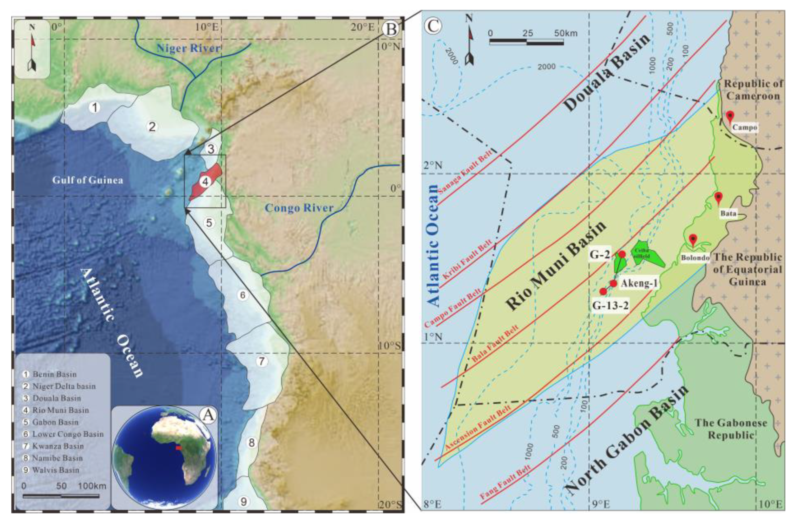
2. Geological Setting

The Rio Muni Basin is located in southern Gulf Guinea, West Africa (Figure 1A,B), which is one of the most important petroliferous areas in the world. With the discovery of the Ceiba oil field in 1999, it directly demonstrated the immense oil and gas potential of the Rio Muni Basin [2,7,27]. It is located in a location with shearing near the equator on the edge of West Africa [28,29,30]. The north is controlled by the Kribi fault zone and is adjacent to the Douala Basin [29]; the south is cut by the Ascension Fault zone and borders the North Gabon Basin [30]; and it is located west of the Central African Precambrian shield (Figure 1B) [31]. The Rio Muni Basin covers a total area of 2.0 × 10⁴ km2, of which 86% is offshore [32]. Its conjugate basin is the petroliferous Sergipe Alagoas Basin in Brazil [28,29]. The formation and evolution of the passive continental margin in West Africa can be subdivided into four major stages that are closely related to the opening of the Atlantic Ocean [33]. The Rio Muni Basin has also experienced a similar sedimentary evolution (Figure 2) [34,35].
Fragmentation of the Gondwanan continent was accompanied by an eruption of continental rift basalt, and no prerift sequence survived it [3]. In the Rio Muni Basin, very few wells have been drilled into the pre-Cretaceous formations, which consist of Precambrian feldspar-bearing sandstone and conglomerate [1].
(1)
Rifting period (or interior fracture phase—Neocomian to early Aptian)
With a series of tensional rifting events from south to north in the South Atlantic, the West African coast has formed an onshore rift system controlled by NE-SW-trending basement fractures [4]. The interlacing of horsts and grabens is the main tectonic pattern of the Rio Muni Basin [36]. The faulted lake basin with a half-graben structure is filled with sapropelic lacustrine source rocks and terrestrial clastic rocks. The sedimentary centre is located in the eastern part of the basin, and the maximum sedimentary thickness is >4000 m, which decreases towards land.
(2)
Rift–drift transitional period (or sag phase—middle to late Aptian)
During this period, under the influence of the Walvis volcanic belt, seawater from the southern side periodically drained into the sedimentary basins (i.e., the Low Congo Basin, the Gabon Basin, the Rio Muni Basin, etc.) on the northern side of the South Atlantic, resulting in the development of extensive evaporite deposits in these basins [32,37]. These evaporites formed a continuous blanket extending from the southern regions of the Douala basin to the northern reaches of the Namibe basin, recording the first transgression in the South Atlantic [38].
(3)
Drifting period (or thermal sag phase—Albian to present)
Continued ocean accretion and continental drift led to the further opening of the South Atlantic [33,39,40]. The Rio Muni Basin entered the passive continental margin stage from this phase. During this period, the basin experienced early gravity deformation, basin inversion and folding, and late gravity deformation phases [8,28,30]. This stage can be divided into three supersequences according to the major changes in the sedimentary environment and widespread unconformities. A restricted marine supersequence characterised by high salinity and hypoxia in shallow marine environments originated from high-energy shallow-water carbonate deposits in a ramp/platform environment [5,41]. During this period, a set of marine source rocks with a total organic carbon (TOC) content higher than 5% and predominantly Type II organic matter, with a smaller amount of Type I, developed, serving as the major hydrocarbon source rocks in the Rio Muni Basin [2,42]. The top is marked by black shale rich in organic matter. The open marine supersequence (or middle postrift stage—Turonian to present) indicates that the ancient water depth reached 1000–2000 m beyond the present-day continental shelf and that the sedimentary environment was stable, which represents the marine sedimentary stage. A set of marine source rocks developed, with a total organic carbon (TOC) content higher than 3%, predominantly consisting of Type II kerogen, and exhibiting immaturity [2,42]. The third supersequence can be distinguished locally, i.e., as a delta supersequence. The northward movement of the African plate gives the continental margin a tropical and humid climate, enhances erosion, and results in the development of a set of downwards-inclined wedge-shaped delta supersequences on the continental shelf slope [43,44,45].

3. Materials and Methods

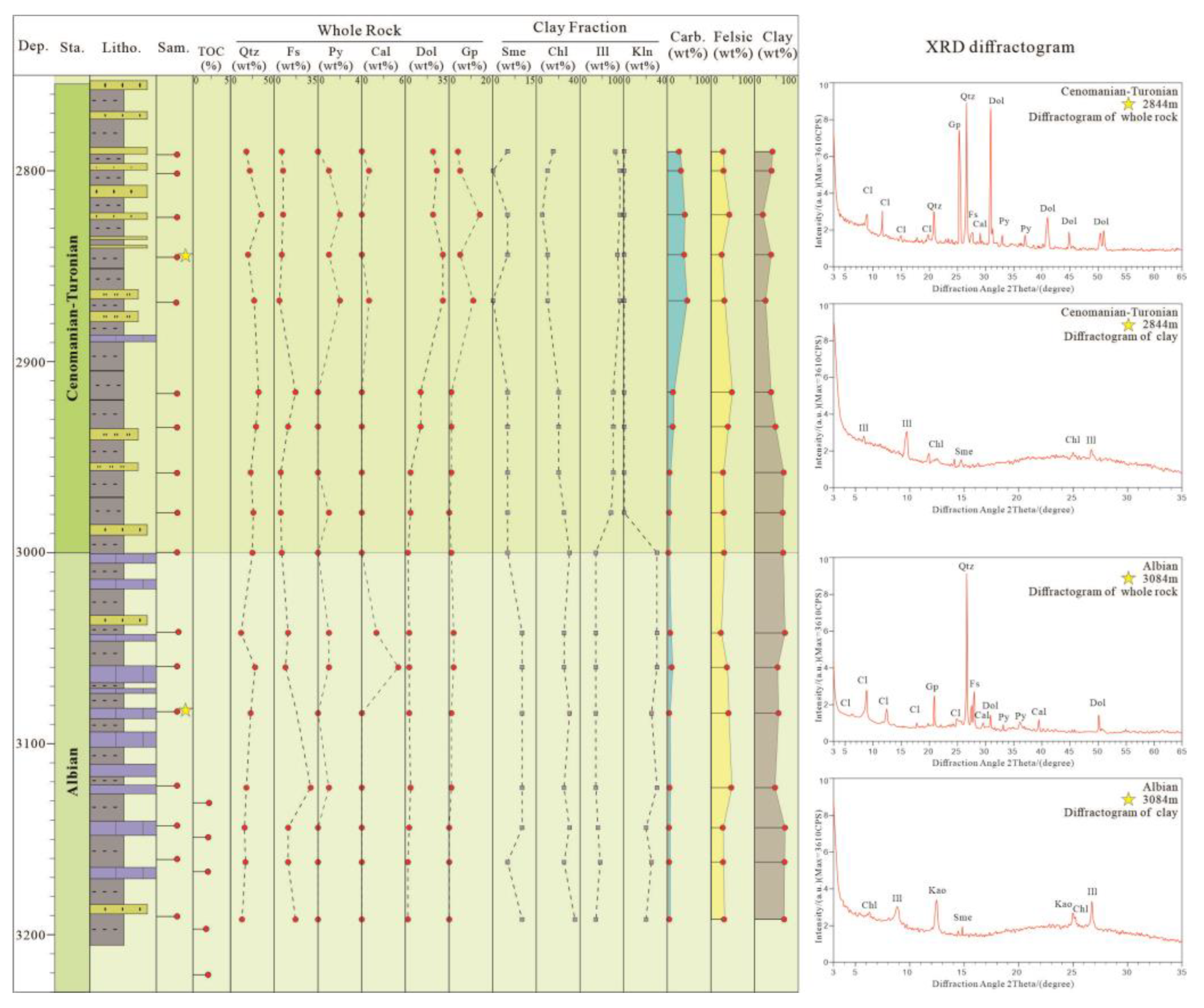
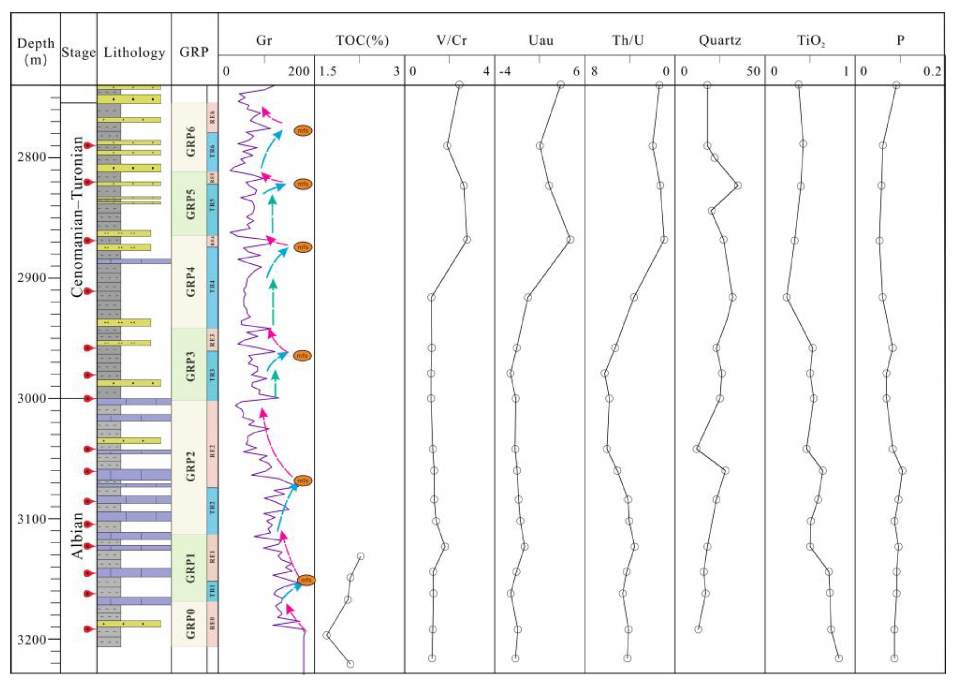
3.1. Well and Sampling

The Akeng-1 well is located in the deepwater area to the south of the Ceiba oilfield (Figure 1C). A total of 17 limited cutting samples were collected exclusively from the deepwater area of the Akeng-1 well in the Rio Muni Basin. Samples of mudstone intervals from different periods of the Albian stage (3000–3231.20 m) and the Cenomanian–Turonian stage (2754.50–3000 m) were collected (Figure 3). These mudstone samples are known to contain organic matter. The lithology of the Albian stage comprises alternating layers of mudstone and limestone, while the Cenomanian–Turonian stage consists of interbedded mudstone and sandstone with thin beds of limestone. The samples were provided by the CNOOC Research Institute in Beijing, China. Most samples were analysed and measured using a series of analytical techniques, including total organic carbon (TOC), X-ray diffraction (XRD), scanning electron microscopy (SEM), energy dispersive spectrometry (EDS), surface scanning, electron backscatter diffraction (EBSD), and thin-section granularity analysis.

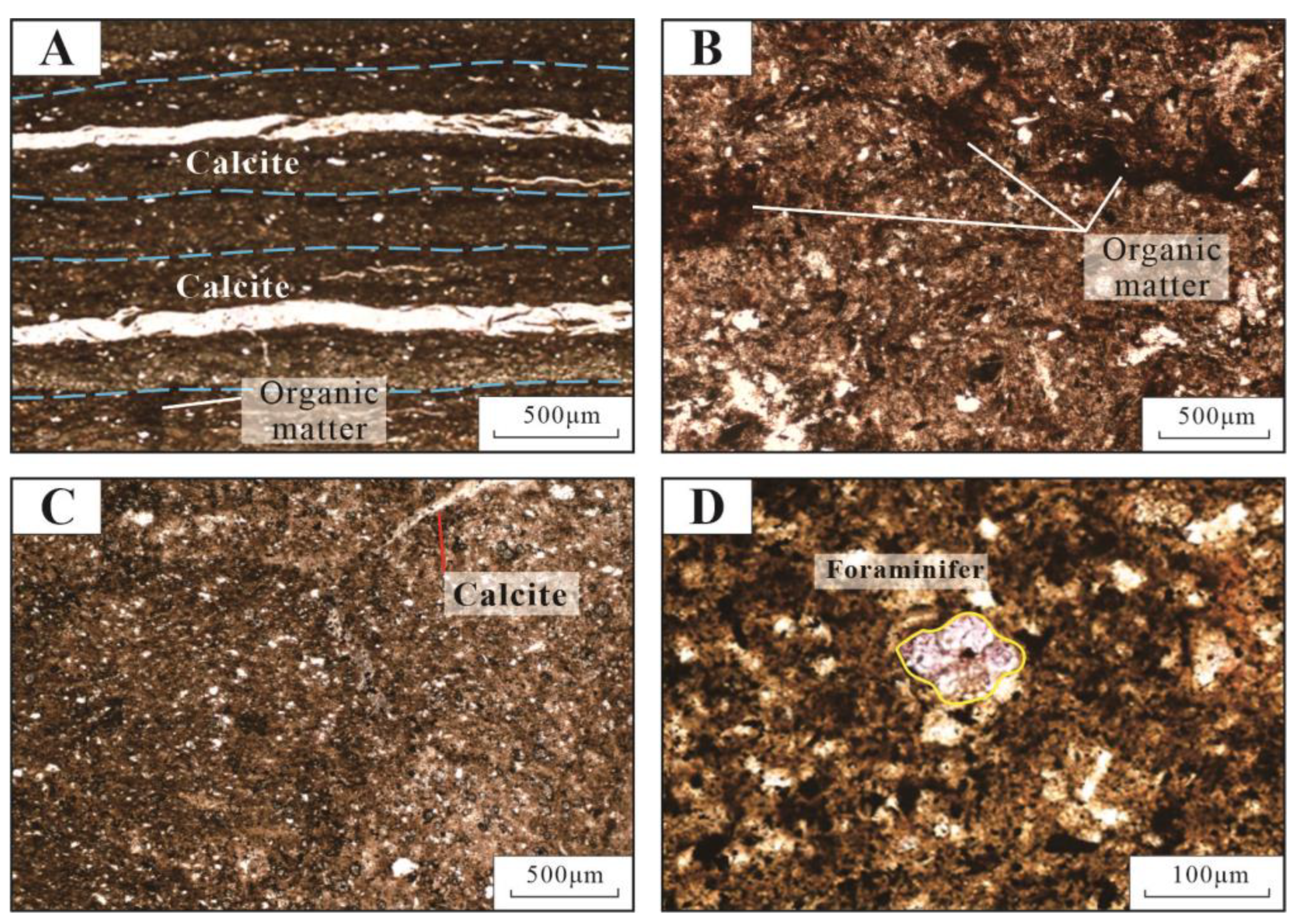
3.2. TOC, XRD, and Thin Sections

TOC (%) is an important index to indicate the abundance of organic matter in study samples. The TOC data were graciously provided by the CNOOC Research Institute in Beijing, China.
The mineralogical compositions of the samples were evaluated using XRD analysis. A Philips PW 1830 diffractometer system equipped with Cu-Kα radiation was employed to analyse 18 pulverised samples (≤200 mesh). The main mineral content and clay mineral composition of the samples were quantified.
We screened representative cutting samples at each depth and processed thin sections and probe tips to support the identification of rock constituents. Additionally, image analysis techniques were employed for grain size analysis of framboidal pyrite.

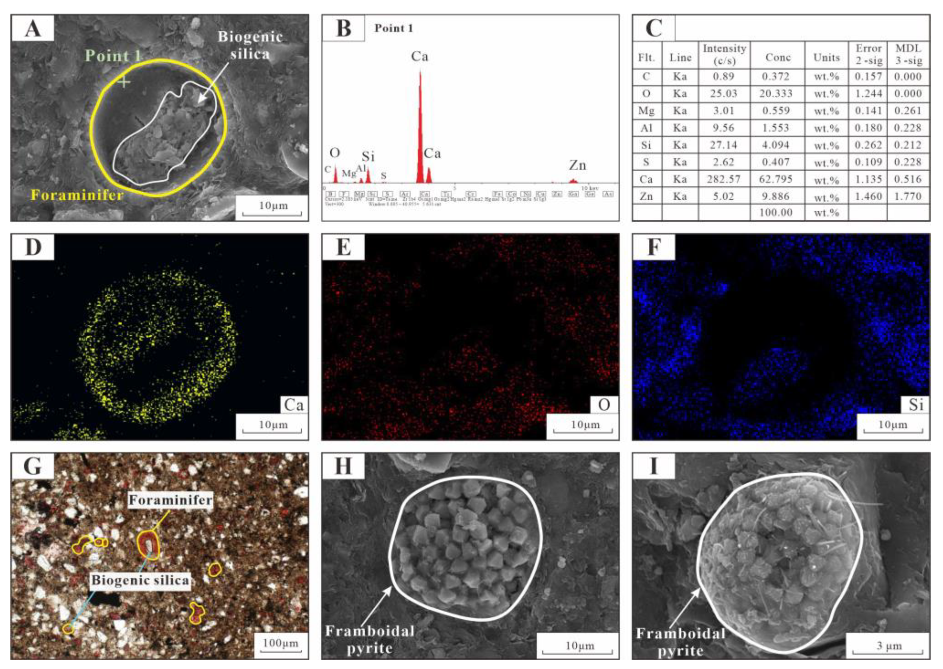
3.3. SEM, EDS, Surface Scanning and EBSD

Scanning electron microscopy (SEM) was used to analyse the mineralogical composition, morphology, and microorganisms. Eighteen samples were analysed with an FEI Quanta 450FEG SEM with a resolution of 1.2 nm and equipped with an SDD Inca X-Max 50 EDS (energy dispersive X-ray spectroscopy) system and a Nordlys II and Channel 5.0 EBSD (electron backscatter diffraction) system. All test processes followed the methodology of JY/T 010-1996. Elemental compositions were tested by surface scanning followed by EDS. The content of conventional ions in each sample was measured using ESCA (X-ray photoelectron spectroscopy) and ICP–AES (inductively coupled plasma-atomic emission spectroscopy). The initial concentration of conventional ions is almost zero, as EDS can accurately reflect the mineral type, and surface scans can accurately reflect the degree of element aggregation.

4. Results

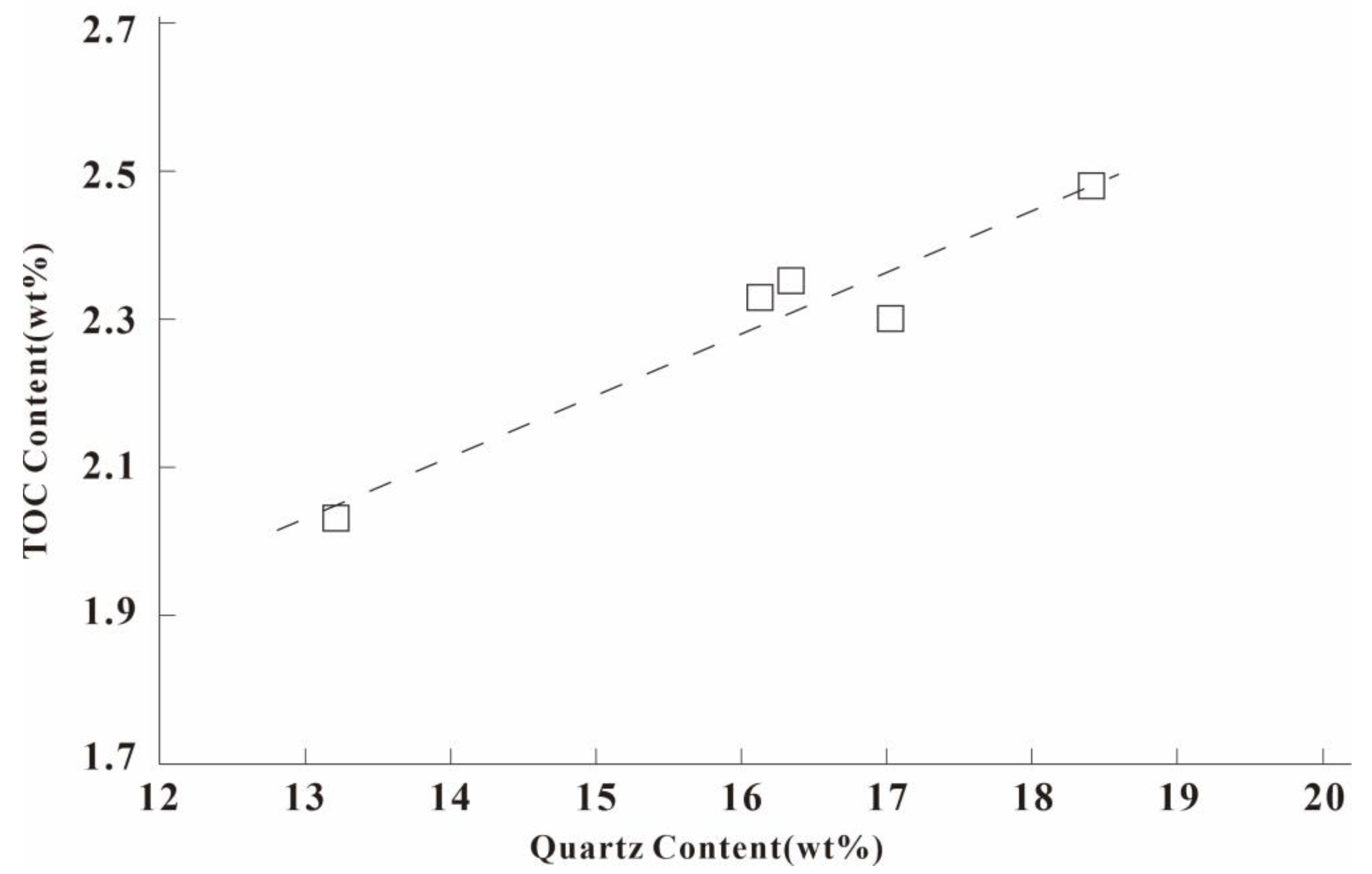
4.1. Mineral Composition

Albian–Turonian fine-grained sedimentary rocks were predominantly composed of clay minerals, quartz, and dolomite (Figure 3, Table 1), with some plagioclase, calcite, gypsum, and pyrite. The clay mineral contents ranged from 19.00% to 70.00%, with an average of 50.84%, and the contents of quartz were 12.39%–35.06%, with an average of 22.47%. Amorphous silica is also found in fine-grained sedimentary rock. Most of them were associated with microorganisms or existed in isolation (broken microbial shell residues) (Figure 4A–G); carbonate components were low, ranging from 1.92% to 44.02%, with an average of 16.09%. Calcite and pyrite were rare, and pyrite mainly occurred as framboidal pyrite (Figure 4H,I). Illite was the predominant clay mineral, along with some kaolinite, smectite, and chlorite. The relative contents of illite ranged from 35% to 90%, whereas the contents of kaolinite were much lower, ranging from 0% to 30%. The relative content of smectite and chlorite ranges from 5% to 10% and 5% to 35%, respectively. Overall, it can be observed that the total content of clay minerals gradually decreases and the content of carbonate minerals gradually increases from the bottom to the top of the stratigraphic section, while the content of felsic minerals remains relatively stable (Figure 3).

4.2. Lithofacies

The term lithofacies refers to rocks or an association of rocks formed in a certain sedimentary environment and is the main component of sedimentary facies [23,46,47]. A complete fine-grained sedimentary rock lithofacies description addresses the mineralogy, geochemistry, and oil and gas potential of fine-grained sedimentary rocks [16,48,49]. Different researchers have established different lithofacies division standards according to different sedimentary settings or research content [16,21,22,23,24,25,48,50]. These division standards are mostly determined using the organic matter content, bedding, rock composition, and mineral composition as the main parameters. Combinations of these four parameters are used to describe the main petrological characteristics of the shale lithofacies, which are indicative of a certain sedimentary depositional environment [16,18,20,21,22,24].
In the Rio Muni Basin, Akeng-1 well, TOC data are exclusively present in the Albian stage. The TOC contents are within 2.03%–2.48%. Based on the characteristics of organic matter, extensive petrography, and mineralogy, the fine-grained sedimentary rocks of the Albian–Turonian stage in the Rio Muni Basin have been divided into three lithofacies, namely, (1) siliceous-clayey fine-grained rock, (2) terrigenous clastic mixed fine-grained rock, and (3) lime-mixed fine-grained rock.
(1)
Siliceous-clayey fine-grained rock
A lithofacies is present in the Albian and Lower Cenomanian–Turonian-stage fine-grained rock interval with high felsic content and whose colour is mainly light grey. The siliceous-clayey fine-grained rock is dominated by clay minerals with an average content of 64.78%; felsic minerals have the second-highest content, in which the average content of quartz is 20.40% and the average content of feldspar is 10.18%. The content of carbonate is low, and the average contents of calcite and dolomite are 0.99% and 2.76%, respectively. The average content of pyrite is 0.39% (Table 1). Thin section observations show that the terrigenous clastic particles in the lithofacies are scattered, and the particle size range is 1–2 μm (Figure 5A). It is dominated by clay-grade silty sand, which forms a floating shape, and the development of laminae is visible locally (Figure 5A). This lithofacies has a high P element content and thus high palaeoproductivity in the study area (Figure 6). The microbial enrichment features found in the thin section also prove this (Figure 7A,D).
(2)
Terrigenous clastic mixed fine-grained rock
The contents of clay minerals and felsic and carbonate rocks in terrigenous clastic mixed fine-grained rocks are all less than 50%. These minerals exist in a small amount in the Albian (Figure 5B) stage and in a greater amount in the Cenomanian–Turonian stage (Figure 5C). The average clay content in terrigenous clastic mixed fine-grained rocks of the Albian stage is 47%; the felsic content is second, in which the average content of quartz is 18.40%; and the average content of feldspar is 28.69%; the content of carbonate minerals is the lowest, with average contents of calcite and dolomite of 0.42% and 3.59%, respectively; and the pyrite content is 0.67% (Table 1). A large number of foraminifera and biological nodules are visible in the thin sections (Figure 7G). The high content of P indicates high palaeoproductivity (Figure 6). The average clay content of Cenomanian–Turonian terrigenous clastic mixed fine-grained rocks is 41.53%. The felsic content is second, in which the average content of quartz is 25.74% and the average content of feldspar is 10.55%. The carbonate mineral content is the lowest: the average content of calcite is 0.99%, and the average content of dolomite is 17.92%. The pyrite content is 0.55% (Table 1). Numerous foraminifera are visible (Figure 7G).
(3)
Lime-mixed fine-grained rock
Lime-mixed fine-grained rock is visible only in the middle of the Cenomanian–Turonian stage (Figure 5D). The average clay content is 27.33%; the content of carbonate minerals is second, with an average content of calcite of 0.53% and an average content of dolomite of 27.50%; the felsic content is low, among which the average content of quartz is 27.14% and the average content of feldspar is 5.68%. The pyrite content is 1.77% (Table 1). Among the three lithofacies, the pyrite content of lime-mixed fine-grained rock is the highest. A large number of foraminifera and biological nodules are visible in the thin sections (Figure 7J,K).

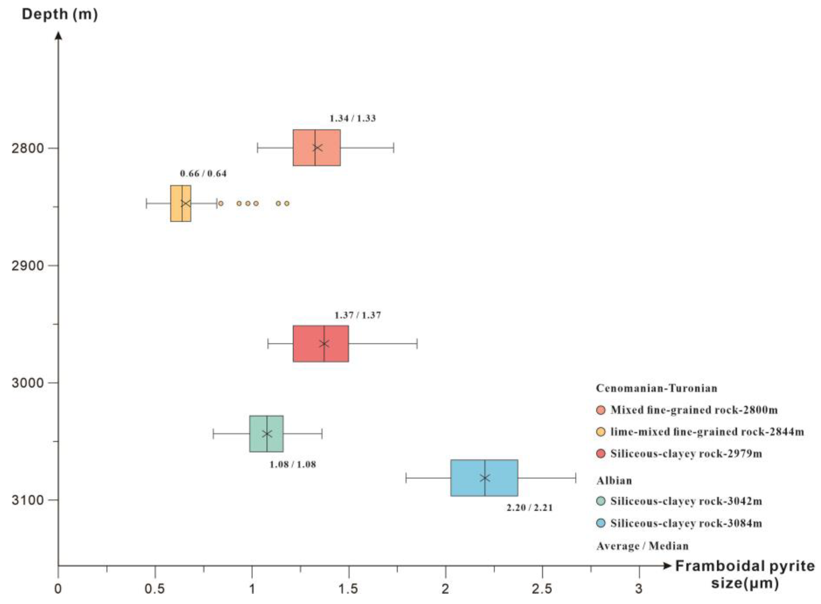
4.3. Framboidal Pyrite

A large amount of framboidal pyrite is found in the fine-grained sedimentary rocks of the Albian–Turonian stage. The average content is 0.74%. The framboidal pyrite is white under SEM (Figure 8). Generally, framboidal pyrite can be used to explain the chemical properties of aqueous environments in formations [13,51,52,53].
Framboidal pyrite is an indirect sediment that generally forms near the oxidation–reduction interface. When it leaves the oxidation–reduction interface, it no longer grows [54,55]. In an oxygen-poor environment, framboidal pyrite is formed in the sediments below the sediment-water interface. In the formation process, reactants are limited in supply, and the particle size distribution is wide. Under a sulfidation environment, framboidal pyrite is formed in the water body above the sediment-water interface. In the formation process, the reactants are supplied infinitely, and the particle size distribution range is relatively concentrated [13,55]. Very fine pyrite framboids (mean of 5 mm; range of 1–18 mm) are typically associated with deposition from a euxinic (anoxic and sulfidic) water column, whereas larger framboids (mean of 10 mm; range of 1–50 mm) are associated with oxic conditions [52].
The sizes of the framboidal pyrite in the Albian–Turonian stage were calculated (Figure 9). The particle size of framboidal pyrite is less than 3 μm. According to the particle size characteristics of framboidal pyrite and geochemical data, we suggest that the existence of framboidal pyrite at this stage is linked to anoxic conditions.

5. Discussion

The sedimentary environment can be indicated by the lithofacies characteristics. In general, the lithofacies colour, sedimentary structure, elemental content, and mineral composition all contain information about the sedimentary environment, such as the hydrodynamic environment, redox environment, sea level information, and depositional events. The depositional environment and deposition models of marine source rocks of the Albian–Turonian stage in the Rio Muni Basin were reconstructed.

5.1. Depositional Model of Albian Source Rocks

5.1.1. Terrestrial Material Supply

Generally, the quality of the source rock is controlled not only by high palaeoproductivity but also by quiet and hypoxic environments. High-quality source rocks are comprehensive products of high palaeoproductivity and good preservation conditions [15,56].
In the Albian stage, the West African plate was not completely separated from the South American plate [8], and the Rio Muni Basin was a restricted sea. Siliceous-clay fine-grained rocks that developed in the Albian stage are mainly composed of clay minerals, with an average content of 62.25%. Quartz and feldspar particles are rare in thin sections, indicating that the hydrodynamic conditions in this period were weak (Figure 5A). Commonly, the organic matter content is negatively correlated with the quartz content, but the quartz content is positively correlated with the TOC content in Albian siliceous clay rocks (Figure 10), indicating that some of the quartz content was provided by biogenic mechanisms. This phenomenon was also found in thin sections (Figure 4A,G). Therefore, clastic particles supplied by terrigenous sources are scarcer.
Generally, the clay mineral composition is one of the important bases for palaeoclimate assessment [57,58]. A warm and humid climate is highly favourable for the formation and preservation of kaolinite. The average content of Albian kaolinite is 26.25% (Table 1). This shows that the climate was warm and humid in the Albian stage. This observation is consistent with the global-scale climate fluctuations during the Albian stage [59,60,61,62,63,64].
Previous studies have shown that there is no autogenous enrichment of TiO2 in the ocean and that TiO2 in marine sediment is supplied by terrigenous materials [65,66]. The average content of TiO2 in the Albian stage is 1 (Table 2). A higher content of TiO2 indicates that it is greatly influenced by terrigenous materials. This ensures the input of a large number of “land-based” nutrients and provides conditions for the reproduction of low marine planktonic algae. This was also confirmed by the studies of Turner (1995), Dailly (2002), and Jiang Zhao (2019) [2,7,8].

5.1.2. Palaeoproductivity

The content of P can be used to assess the productivity of the ancient ocean [67,68] (Figure 6). The average content of P in the Albian stage in well Akeng-1 is 0.89 mg/g. (Figure 6, Table 2). This indicates a higher level of nutrients during this period. Rich nutrient elements and a warm and humid shallow-water environment are very conducive to the growth of microorganisms. This is also confirmed by the palaeontological enrichment observed in thin sections under the microscope (Figure 7A,D,L). The above characteristics indicate that the Rio Muni Basin was a neritic shelf sedimentary environment under restricted sea conditions during the Albian stage sedimentary period. Quiet waters, warm and humid climates, and a rich supply of terrestrial nutrients are very suitable for the growth of marine algae. Thus, during this period, the basin had high palaeoproductivity. This phenomenon is consistent with the occurrence of high palaeoproductivity in the Atlantic during this period. It can be attributed to intensified continental weathering, resulting in increased nutrient discharge into the oceans and lakes [60,69,70,71,72,73,74].

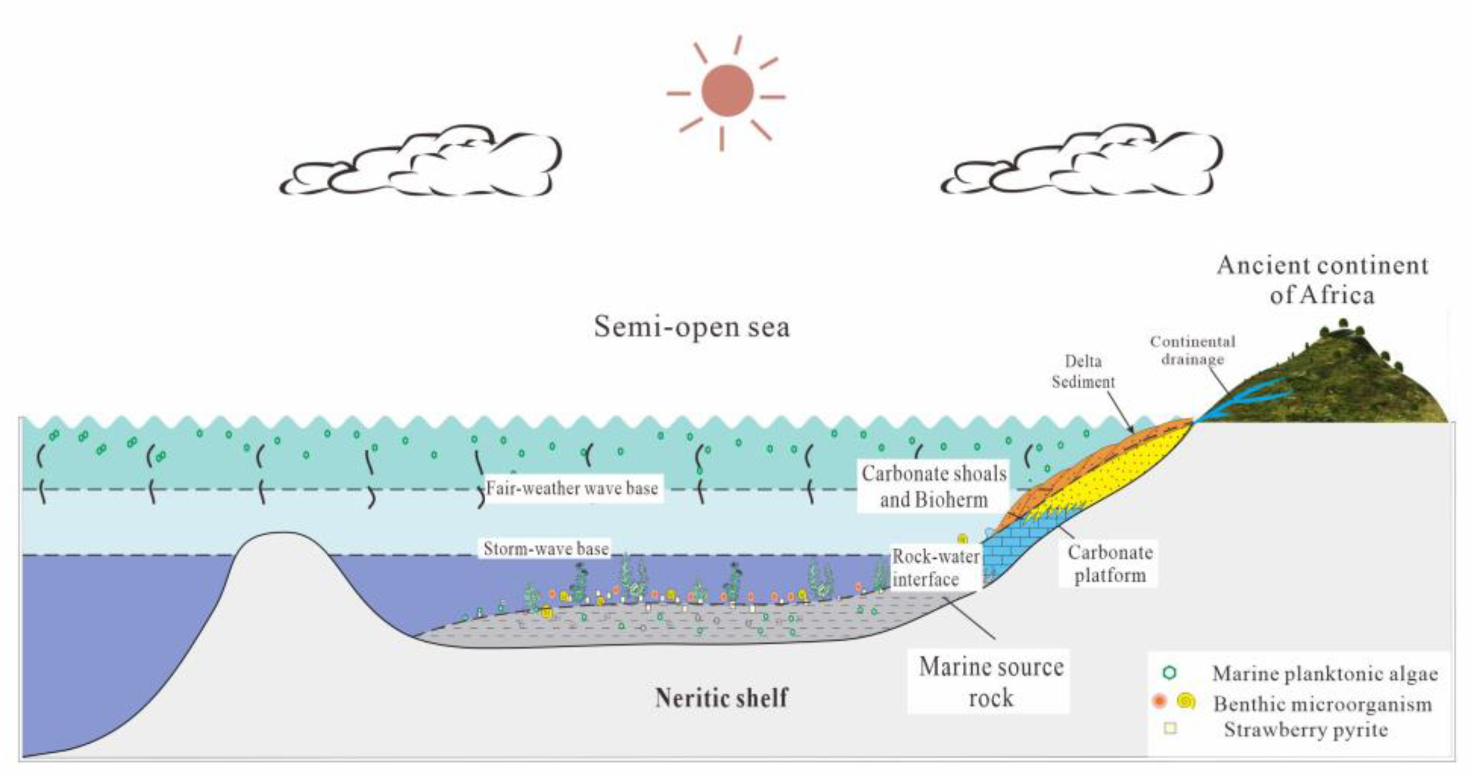
5.1.3. Depositional Environment

The primary colour of the rocks could be used to discern the oxygen content in sedimentary water [15,23,75,76,77]. A darker colour indicates a lower oxygen content. A lighter colour corresponds to a higher oxygen content. Generally, red or brown reflects an oxic environment, green indicates a weakly reducing environment, light grey reflects a weakly reducing–partially oxidising environment, and dark grey and black indicate a restored environment or restricted environment, respectively. The major colour of the Albian stage is light grey (Figure 6, Table 2), indicating that the Albian stage was dominated by an oxidising environment [15,23,75,76,77].
In this paper, geochemical elements are also used to analyse the sedimentary environment (Figure 6). Generally, V/Cr [78,79], Th/U [80,81,82], and Uau (Uau = Uto − Th/3, Uto is the total U) [78,81] element ratios are used to indicate the redox environment of sedimentary water. Studies have shown that values of V/Cr < 2, Th/U > 2, and Uau < 12 × 10−6 indicate an oxidising environment [78,79,80,81,82]. The V/Cr values of the Albian fine-grained sedimentary rocks range from 1.17 to 1.79, the Th/U values range from 3.57 to 6.06, and the Uau values range from −2.23 to −0.69, suggesting oxidising conditions in the Albian fine-grained sedimentary rocks [59,60,61,62,63,64].
The size range of Albian framboidal pyrite is 0.80–2.68 μm, with small and concentrated size distributions (Figure 9). We suggest that this is due to the intermittent influx and evaporation of seawater in the restricted-sea environment, resulting in the fluctuation of the seabed redox interface. Thus, it affects the growth of framboidal pyrite. Therefore, in the Rio Muni Basin, the Albian-stage sedimentary water was an oxidising environment overall, but there was a reducing environment in the local low position.

5.1.4. Depositional Model of the Albian Stage

On the basis of lithofacies characteristics, facies, organic geochemistry, microbial characteristics, and comparisons with regional sedimentological and tectonic features, we propose a model (Figure 11) that accounts for a sedimentary process of marine source rocks developed in the Albian stage. We suggest that the marine source rocks in the Albian stage of the Rio Muni Basin are most appropriately interpreted as having formed in a neritic shelf sedimentary environment under a restricted sea setting. In this period, under the warm and humid climate environment, the relatively quiet water body contained rich nearshore terrestrial nutrients, which provided a very comfortable palaeoenvironment for the growth of marine algae. Although redox indicators of marine source rocks indicate poor preservation conditions during this period, the strata are relatively thick, and a set of continental margin–bay-limited marine source rocks dominated by marine algae was still formed.

5.2. Depositional Model of Cenomanian–Turonian Source Rocks

5.2.1. Terrestrial Material Supply

In the Cenomanian–Turonian stage, with the opening of the South Atlantic, the Rio Muni Basin gradually entered the open-sea area. Three lithofacies of siliceous clayey rock, terrigenous clastic mixed fine-grained rock, and lime mixed fine-grained rock are present in fine-grained rocks of the Cenomanian Turonian stage. This indicates that there were frequent changes in hydrodynamic conditions during this period [83,84,85,86]. In the rocks deposited during this period, the contents of clay minerals range from 19% to 67% and show a decreasing trend. The mineral contents of felsic and carbonate rocks are 25.12%–48.69% and 4.59%–44.02%, respectively, and show fluctuating changes (Table 1). The increase in mineral contents of felsic and carbonate rocks indicates a strengthening of terrestrial supple compared to the Albian stage, with frequent variations. The frequent and periodic occurrence of fine-grained lithofacies in the upper Cenomanian–Turonian stage also represents frequent and periodic changes in sediment input and hydrodynamic energy.
The Rio Muni Basin during the Albian stage was characterised by a restricted marine environment. However, as the global sea level rose during the Cenomanian–Turonian stage [87], there was a gradual connection between the basin’s water bodies and the open ocean. Nonetheless, certain areas within the basin remained confined [1,59]. The Cenomanian–Turonian stage does not contain kaolinite, and the clay mineral assemblage is dominated by illite and chlorite. The content of kaolinite indicates a weak terrigenous sediment input [88,89,90,91]. TiO2 is mainly produced as precipitates in the initial stage of weathering from crystalline parent rocks [59,92,93,94]. The element has a low concentration in the ocean and is mostly derived from terrigenous sediment input [95]. The content of TiO2 was higher in the early stage and decreased significantly in the middle and late stages (Figure 6, Table 2). This result also indicates that the supply of terrigenous clastic sediment was small. However, the combined pattern of siltstone mixed with shale in this stage reflects the intermittent strong supply of terrigenous materials. During this period, the Rio Muni Basin deposited nearshore delta sediments with intermittent input of terrestrial material, including carbonate platform sediments, into the neritic shelf. Most foraminifera under SEM are broken (Figure 7G,K), which is also evidence of this view. Zhao (2019) confirmed that the organic matter types in this stage were imported from marine algae and terrestrial higher plants by measuring macerals [2].

5.2.2. Palaeoproductivity

The average content of P in the Cenomanian–Turonian stage in well Akeng-1 is 0.65 mg/g (Table 2, Figure 12). This indicates a higher level of nutrients during this period [60,69,70,71,72,73,74]. It provides a material basis for the development of organic matter. This is also confirmed by the palaeontological enrichment observed in thin sections under the microscope (Figure 7G,J,K).

5.2.3. Depositional Environment

The V/Cr values of the Cenomanian–Turonian fine-grained sedimentary rocks range from 1.17 to 2.77, the Th/U values range from 0.94 to 6.25, and the Uau values range from −2.3 to 4.41. This indicates that the basin experienced changes between oxidising and reducing environments during this period. The figure (Figure 6, Table 2) shows a gradual decrease in the oxygen content in Cenomanian–Turonian fine-grained sedimentary rocks. In the late Cenomanian–Turonian stage, it was an anoxic environment. The colour of fine-grained sedimentary rocks in this period gradually changed from light grey in the early stage to dark grey in the late stage, reflecting the transformation of sedimentary water from an oxidising environment to a reducing environment.
The pyrite content in the late Cenomanian–Turonian stage (0%–2%) is higher than that in the Albian stage (0%–1%) (Table 1). The particle sizes of framboidal pyrite range from 0.80 to 2.68 μm. The particle size is small, and the overall characteristics are similar to those of the Albian stage (Figure 9).
During the Cenomanian–Turonian deposition period, both the element ratios and the primary colour of rock indicate a transition from early oxidising to late reducing environments in the Rio Muni Basin. This aligns with the concurrent global “oceanic anoxic event” observed in various regions such as the Lower Congo Basin, Morocco, Europe, and Tunisia, which exhibit similar characteristics [69,71,96,97].

5.2.4. Depositional Model of the Cenomanian–Turonian Stage

The aforementioned features indicate that the Rio Muni Basin was a shelf sedimentary environment in a transitional environment from the restricted sea to the semiopen sea during the Cenomanian–Turonian stage sedimentary period, with the development of delta sediments. The rise in sea level increased the transport distance of the source area, but intermittent strong hydrodynamic conditions still brought rich nutrients and land-based higher plants [2,98,99,100]. It provided good conditions for the growth of organic matter.
On the basis of lithofacies characteristics, facies, organic geochemistry, microbial characteristics, and comparisons with regional sedimentological and tectonic features, we propose a model (Figure 12) that accounts for a sedimentary process of marine source rocks developed in the Cenomanian–Turonian stage. We suggest that the marine source rocks in the Cenomanian–Turonian stage of the Rio Muni Basin are most appropriately interpreted as having formed in a shallow-shelf sedimentary environment under a restricted-semiopen marine environment. Compared with that in the Albian, the water body was deeper. The effect of terrestrial supply was weak but accompanied by intermittent strong supply. During this period, the climate was dry, and the offshore distance became longer with the rise in sea level. In the early stage, the water was quiet, and the nutrient content of the water was low; in the middle and late periods, intermittent strong hydrodynamics provided sufficient nutrients and terrigenous organic matter. Although the Cenomanian–Turonian strata are relatively thin and the marine source rocks have low maturity, they have good preservation conditions and high palaeoproductivity; they form a set of restricted-semiopen marine source rocks formed in the continental margin of a mixed marine source.

6. Conclusions

The fine-grained sedimentary rocks of the Albian and Cenomanian–Turonian stages are highly heterogeneous formations. The lithofacies can be defined from the mineral composition, clay percentage, ratios of quartz and carbonate, and TOC content. These are the key criteria for recognising the Albian and Cenomanian–Turonian fine-grained sedimentary rock lithofacies. Three lithofacies have been identified: (1) siliceous-clayey rock, (2) terrigenous clastic mixed fine-grained rock, and (3) lime-mixed fine-grained rock. The Albian stage is dominated by siliceous-clay rock. The Cenomanian–Turonian stage is mainly composed of mixed fine-grained rock types.
The lithofacies characteristics show that the Albian period was a confined sea and offshore shelf sedimentary environment with quiet water and a close distance to the source area. Abundant nutrients, high palaeoproductivity, and generally good preservation conditions were observed, but the formation was a set of thick, high-maturity, marine endogenous, high-quality hydrocarbon source rocks.
The Cenomanian–Turonian stage was a semiopen and open marine shelf sedimentary environment far from the source area but with strong intermittent hydrodynamics. Nutrients were abundant, and the organic matter types were mainly marine algae and terrigenous higher plants. Owing to the Cretaceous hypoxia event, the preservation conditions were good. A set of marine mixed-source rocks was developed.

Author Contributions

Conceptualisation, investigation, writing—original draft preparation, review, validation, and editing, B.Z.; methodology, validation, formal analysis, and editing, B.Z.; supervision, methodology, project administration, and data curation, Z.Z. and H.Z.; methodology, supervision, project administration, and funding acquisition, X.Y.; software, data curation, and project administration, L.P. All authors have read and agreed to the published version of the manuscript.

Funding

The project was supported by the “CUG Scholar” Scientific Research Funds at China University of Geosciences (Wuhan) (Project No.2022148) and National Science and Technology Major Projects (No. 2017ZX05032-001-002).

Data Availability Statement

Not applicable.

Acknowledgments

The Beijing Research Institute of the China National Offshore Oil Corporation is thanked for providing the data used in this study and the permission to publish the results.

Conflicts of Interest

The authors declare no conflict of interest.

References

  1. Brownfield, M.E.; Charpentier, R.R. Geology and Total Petroleum Systems of the West-Central Coastal Province (7203), West Africa; Bulletin; U.S. Geological Survey: Washington, DC, USA, 2006; Volume 2207-B, p. 59. [Google Scholar]
  2. Zhao, J.; Cao, J.; Zhong, N.-N. Characteristics, Origin and Hydrocarbon Potential of the Upper Cretaceous Source Rock in the Rio Muni Basin, Equatorial Guinea. In Proceedings of the IOP Conference Series: Materials Science and Engineering; IOP Publishing: Bristol, UK, 2019; Volume 592, p. 012172. [Google Scholar]
  3. Lu, B.; Wang, W.; Du, X.; Huang, X.; Guo, Y.; Ji, X.; Feng, X. Review of Tectonic-Sedimentary Features of the Central-South Section of West African Continental Margin Basins. Adv. Mar. Sci. 2015, 33, 414–428. [Google Scholar] [CrossRef]
  4. Fu, Z.; Jiang, X.; Xiao, Y.; Wang, G.; Li, C.; Zhang, W. Tectonic Evolution and Petroleum Exploration Prospect in Rio Muni Basin, Equatorial Guinea. Mar. Geol. Front. 2014, 30, 41–47. [Google Scholar] [CrossRef]
  5. Beglinger, S.E.; Doust, H.; Cloetingh, S. Relating Petroleum System and Play Development to Basin Evolution: West African South Atlantic Basins. Mar. Pet. Geol. 2012, 30, 1–25. [Google Scholar] [CrossRef]
  6. Deng, R.; Deng, Y.; Yu, S.; Hou, D. Hydrocarbon Exploration Achievements and Exploration Potential of Coastal Basins in West Africa. Offshore Oil 2008, 28, 11–19. [Google Scholar] [CrossRef]
  7. Dailly, P.; Lowry, P.; Goh, K.; Monson, G. Exploration and Development of Ceiba Field, Rio Muni Basin, Southern Equatorial Guinea. Lead. Edge 2002, 21, 1140–1146. [Google Scholar] [CrossRef]
  8. Turner, J.P. Gravity-Driven Structures and Rift Basin Evolution: Rio Muni Basin, Offshore Equatorial West Africa. AAPG Bull. 1995, 79, 1138–1158. [Google Scholar] [CrossRef]
  9. Aplin, A.C.; Macquaker, J.H.S. Mudstone Diversity: Origin and Implications for Source, Seal, and Reservoir Properties in Petroleum Systems. AAPG Bull. 2011, 95, 2031–2059. [Google Scholar] [CrossRef]
  10. Krumbein, W.C. Shales and Their Environmental Significance. J. Sediment. Res. 1947, 17, 101–108. [Google Scholar] [CrossRef]
  11. Krumbein, W.C. The Dispersion of Fine-Grained Sediments for Mechanical Analysis. J. Sediment. Res. 1933, 3, 121–135. [Google Scholar] [CrossRef]
  12. Zou, C.; Yang, Z.; Zhang, G.; Hou, L.; Zhu, R.; Tao, S.; Yuan, X.; Dong, D.; Wang, Y.; Guo, Q.; et al. Conventional and Unconventional Petroleum “Orderly Accumulation”: Concept and Practical Significance. Pet. Explor. Dev. 2014, 41, 14–30. [Google Scholar] [CrossRef]
  13. Wilkin, R.T.; Barnes, H.L.; Brantley, S.L. The Size Distribution of Framboidal Pyrite in Modern Sediments: An Indicator of Redox Conditions. Geochim. Cosmochim. Acta 1996, 60, 3897–3912. [Google Scholar] [CrossRef]
  14. Han, C.; Jiang, Z.; Han, M.; Wu, M.; Lin, W. The Lithofacies and Reservoir Characteristics of the Upper Ordovician and Lower Silurian Black Shale in the Southern Sichuan Basin and Its Periphery, China. Mar. Pet. Geol. 2016, 75, 181–191. [Google Scholar] [CrossRef]
  15. Zhang, M.-M.; Liu, Z.-J.; Xu, S.-Z.; Hu, X.-F.; Sun, P.-C.; Wang, Y.-L. Analysis for the Paleosalinity and Lake-Level Changes of the Oil Shale Measures in the Lucaogou Formation in the Sangonghe Area of Southern Margin, Junggar Basin. Pet. Sci. Technol. 2014, 32, 1973–1980. [Google Scholar] [CrossRef]
  16. Loucks, R.G.; Ruppel, S.C. Mississippian Barnett Shale: Lithofacies and Depositional Setting of a Deep-Water Shale-Gas Succession in the Fort Worth Basin, Texas. AAPG Bull. 2007, 91, 579–601. [Google Scholar] [CrossRef]
  17. Wang, G.; Carr, T.R. Methodology of Organic-Rich Shale Lithofacies Identification and Prediction: A Case Study from Marcellus Shale in the Appalachian Basin. Comput. Geosci. 2012, 49, 151–163. [Google Scholar] [CrossRef]
  18. Liu, B.; Wang, H.; Fu, X.; Bai, Y.; Bai, L.; Jia, M.; He, B. Lithofacies and Depositional Setting of a Highly Prospective Lacustrine Shale Oil Succession from the Upper Cretaceous Qingshankou Formation in the Gulong Sag, Northern Songliao Basin, Northeast China. AAPG Bull. 2019, 103, 405–432. [Google Scholar] [CrossRef]
  19. Chen, S.; Zhang, S.; Wang, Y.; Tan, M. Lithofacies Types and Reservoirs of Paleogene Fine-Grained Sedimentary Rocks Dongying Sag, Bohai Bay Basin, China. Pet. Explor. Dev. 2016, 43, 218–229. [Google Scholar] [CrossRef]
  20. Du, X.-B.; Zhang, M.-Q.; Lu, Y.-C.; Ping, C.; Lu, Y.-B. Lithofacies and Depositional Characteristics of Gas Shales in the Western Area of the Lower Yangtze, China. Geol. J. 2015, 50, 683–701. [Google Scholar] [CrossRef]
  21. Jadoon, Q.K.; Roberts, E.M.; Henderson, B.; Blenkinsop, T.G.; Wüst, R.A.; Mtelela, C. Lithological and Facies Analysis of the Roseneath and Murteree Shales, Cooper Basin, Australia. J. Nat. Gas Sci. Eng. 2017, 37, 138–168. [Google Scholar] [CrossRef]
  22. Wang, G.; Carr, T.R. Organic-Rich Marcellus Shale Lithofacies Modeling and Distribution Pattern Analysis in the Appalachian Basin. AAPG Bull. 2013, 97, 2173–2205. [Google Scholar] [CrossRef]
  23. Zhang, M.; Li, Z. The Lithofacies and Reservoir Characteristics of the Fine-Grained Sedimentary Rocks of the Permian Lucaogou Formation at the Northern Foot of Bogda Mountains, Junggar Basin (NW China). J. Pet. Sci. Eng. 2018, 170, 21–39. [Google Scholar] [CrossRef]
  24. Liang, C.; Jiang, Z.; Cao, Y.; Wu, M.; Guo, L.; Zhang, C. Deep-Water Depositional Mechanisms and Significance for Unconventional Hydrocarbon Exploration: A Case Study from the Lower Silurian Longmaxi Shale in the Southeastern Sichuan Basin. AAPG Bull. 2016, 100, 773–794. [Google Scholar] [CrossRef]
  25. Liang, C.; Jiang, Z.; Yang, Y.; Wei, X. Shale Lithofacies and Reservoir Space of the Wufeng–Longmaxi Formation, Sichuan Basin, China. Pet. Explor. Dev. 2012, 39, 736–743. [Google Scholar] [CrossRef]
  26. Ozkan, A.; Cumella, S.P.; Milliken, K.L.; Laubach, S.E. Prediction of Lithofacies and Reservoir Quality Using Well Logs, Late Cretaceous Williams Fork Formation, Mamm Creek Field, Piceance Basin, Colorado. AAPG Bull. 2011, 95, 1699–1723. [Google Scholar] [CrossRef]
  27. Dailly, P.; Goh, K.; Lowry, P. The Rio Muni Basin of Equatorial Guinea: A New Hydrocarbon Province. In Petroleum Systems of Deep-Water Basins–Global and Gulf of Mexico Experience; Fillon, R.H., Rosen, N.C., Weimer, P., Lowrie, A., Pettingill, H., Phair, R.L., Roberts, H.H., van Hoom, H.H., Eds.; SEPM Society for Sedimentary Geology: Tulsa, OK, USA, 2001; Volume 21, pp. 241–251. ISBN 978-0-9836096-9-8. [Google Scholar]
  28. Lawrence, S.R.; Munday, S.; Bray, R. Regional Geology and Geophysics of the Eastern Gulf of Guinea (Niger Delta to Rio Muni). Lead. Edge 2002, 21, 1112–1117. [Google Scholar] [CrossRef]
  29. Meyers, J.B.; Rosendahl, B.R.; Groschel-Becker, H.; Austin, J.A.; Rona, P.A. Deep Penetrating MCS Imaging of the Rift-to-Drift Transition, Offshore Douala and North Gabon Basins, West Africa. Mar. Pet. Geol. 1996, 13, 791–835. [Google Scholar] [CrossRef]
  30. Turner, J.P.; Rosendahl, B.R.; Wilson, P.G. Structure and Evolution of an Obliquely Sheared Continental Margin: Rio Muni, West Africa. Tectonophysics 2003, 374, 41–55. [Google Scholar] [CrossRef]
  31. Wilson, P.G.; Turner, J.P.; Westbrook, G.K. Structural Architecture of the Ocean–Continent Boundary at an Oblique Transform Margin through Deep-Imaging Seismic Interpretation and Gravity Modelling: Equatorial Guinea, West Africa. Tectonophysics 2003, 374, 19–40. [Google Scholar] [CrossRef]
  32. Lv, F.; Xu, Z.; Fan, G.; Shao, D.; Mao, C. Petroleum Geology and Exploration Directions in Rio Muni Basin, Equatorial Guinea. Mar. Pet. Geol. 2011, 16, 45–50. [Google Scholar] [CrossRef]
  33. Basilone, L.; Roberts, G.G.; Almeida, N.M.; Fernandes, V.M.; Souza, A.C.B.; Alves, D.P.V.; Jovane, L. Cretaceous to Recent Tectono-Sedimentary History and Subsidence of the Barreirinhas, Ceará and Potiguar Basins, Brazilian Equatorial Margin. Basin Res. 2023, 7, 1–24. [Google Scholar] [CrossRef]
  34. Basile, C.; Mascle, J.; Guiraud, R. Phanerozoic Geological Evolution of the Equatorial Atlantic Domain. J. Afr. Earth Sci. 2005, 43, 275–282. [Google Scholar] [CrossRef]
  35. Lehner, P.; De Ruiter, P.A.C. Structural History of Atlantic Margin of Africa. AAPG Bull. 1977, 61, 961–981. [Google Scholar] [CrossRef]
  36. Olsen, P.E. Giant Lava Flows, Mass Extinctions, and Mantle Plumes. Science 1999, 284, 604–605. [Google Scholar] [CrossRef]
  37. Jackson, M.P.; Cramez, C.; Fonck, J.-M. Role of Subaerial Volcanic Rocks and Mantle Plumes in Creation of South Atlantic Margins: Implications for Salt Tectonics and Source Rocks. Mar. Pet. Geol. 2000, 17, 477–498. [Google Scholar] [CrossRef]
  38. Rasmussen, E.S. Structural Evolution and Sequence Formation Offshore South Gabon during the Tertiary. Tectonophysics 1996, 266, 509–523. [Google Scholar] [CrossRef]
  39. Aslanian, D.; Moulin, M.; Olivet, J.-L.; Unternehr, P.; Matias, L.; Bache, F.; Rabineau, M.; Nouzé, H.; Klingelheofer, F.; Contrucci, I.; et al. Brazilian and African Passive Margins of the Central Segment of the South Atlantic Ocean: Kinematic Constraints. Tectonophysics 2009, 468, 98–112. [Google Scholar] [CrossRef]
  40. Karner, G.D.; Driscoll, N.W.; Barker, D.H.N. Syn-Rift Regional Subsidence across the West African Continental Margin: The Role of Lower Plate Ductile Extension. Geol. Soc. Lond. Spec. Publ. 2003, 207, 105–129. [Google Scholar] [CrossRef]
  41. Dias-Brito, D. The Meso-Cretaceous of the Campos Basin–a Contribution to the Paleo-Oceanography of the Early South Atlantic. Rev. Bras. De Geocienc. 1987, 17, 162–167. [Google Scholar] [CrossRef]
  42. Liu, Q.; Hu, X.; Yu, S.; Yu, Y.; Zhang, Y.; Hao, L.; Peng, J. Petroleum Geology and Reservoir Formation Characteristics of Rio Muni Basin in West Africa. Offshore Oil 2012, 32, 23–28. [Google Scholar]
  43. Babonneau, N.; Savoye, B.; Cremer, M.; Bez, M. Multiple Terraces within the Deep Incised Zaire Valley (ZaïAngo Project): Are They Confined Levees? Geol. Soc. Lond. Spec. Publ. 2004, 222, 91–114. [Google Scholar] [CrossRef]
  44. Droz, L.; Marsset, T.; Ondreas, H.; Lopez, M.; Savoye, B.; Spy-Anderson, F.-L. Architecture of an Active Mud-Rich Turbidite System: The Zaire Fan (Congo–Angola Margin Southeast Atlantic) Results from ZaïAngo 1 and 2 Cruises. AAPG Bull. 2003, 87, 1145–1168. [Google Scholar] [CrossRef]
  45. Séranne, M.; Anka, Z. South Atlantic Continental Margins of Africa: A Comparison of the Tectonic vs Climate Interplay on the Evolution of Equatorial West Africa and SW Africa Margins. J. Afr. Earth Sci. 2005, 43, 283–300. [Google Scholar] [CrossRef]
  46. Dimberline, A.J.; Bell, A.; Woodcock, N.H. A Laminated Hemipelagic Facies from the Wenlock and Ludlow of the Welsh Basin. J. Geol. Soc. 1990, 147, 693–701. [Google Scholar] [CrossRef]
  47. Lemons, D.R.; Chan, M.A. Facies Architecture and Sequence Stratigraphy of Fine-Grained Lacustrine Deltas along the Eastern Margin of Late Pleistocene Lake Bonneville, Northern Utah and Southern Idaho. AAPG Bull. 1999, 83, 635–665. [Google Scholar] [CrossRef]
  48. Abouelresh, M.O.; Slatt, R.M. Lithofacies and Sequence Stratigraphy of the Barnett Shale in East-Central Fort Worth Basin, Texas. AAPG Bull. 2012, 96, 1–22. [Google Scholar] [CrossRef]
  49. Lazar, O.R.; Bohacs, K.M.; Macquaker, J.H.; Schieber, J.; Demko, T.M. Capturing Key Attributes of Fine-Grained Sedimentary Rocks In Outcrops, Cores, and Thin Sections: Nomenclature and Description GuidelinesMUDSTONES: NOMENCLATURE AND DESCRIPTION GUIDELINES. J. Sediment. Res. 2015, 85, 230–246. [Google Scholar] [CrossRef]
  50. Hickey, J.J.; Henk, B. Lithofacies Summary of the Mississippian Barnett Shale, Mitchell 2 TP Sims Well, Wise County, Texas. AAPG Bull. 2007, 91, 437–443. [Google Scholar] [CrossRef]
  51. Bond, D.P.; Wignall, P.B. Pyrite Framboid Study of Marine Permian–Triassic Boundary Sections: A Complex Anoxic Event and Its Relationship to Contemporaneous Mass Extinction. Geol. Soc. Am. Bull. 2010, 122, 1265–1279. [Google Scholar] [CrossRef]
  52. Wilkin, R.T.; Barnes, H.L. Formation Processes of Framboidal Pyrite. Geochim. Cosmochim. Acta 1997, 61, 323–339. [Google Scholar] [CrossRef]
  53. Zhou, C.; Jiang, S.-Y. Palaeoceanographic Redox Environments for the Lower Cambrian Hetang Formation in South China: Evidence from Pyrite Framboids, Redox Sensitive Trace Elements, and Sponge Biota Occurrence. Palaeogeogr. Palaeoclimatol. Palaeoecol. 2009, 271, 279–286. [Google Scholar] [CrossRef]
  54. Canfield, D.E.; Thamdrup, B. The Production of 34S-Depleted Sulfide during Bacterial Disproportionation of Elemental Sulfur. Science 1994, 266, 1973–1975. [Google Scholar] [CrossRef] [PubMed]
  55. Raiswell, R. Pyrite Texture, Isotopic Composition and the Availability of Iron. Am. J. Sci. 1982, 282, 1244–1263. [Google Scholar] [CrossRef]
  56. Ariztegui, D.; Farrimond, P.; McKenzie, J.A. Compositional Variations in Sedimentary Lacustrine Organic Matter and Their Implications for High Alpine Holocene Environmental Changes: Lake St. Moritz, Switzerland. Org. Geochem. 1996, 24, 453–461. [Google Scholar] [CrossRef]
  57. Jacobs, M.B.; Hays, J.D. Paleo-Climatic Events Indicated by Mineralogical Changes in Deep-Sea Sediments. J. Sediment. Res. 1972, 42, 889–898. [Google Scholar] [CrossRef]
  58. Singer, A. The Paleoclimatic Interpretation of Clay Minerals in Sediments—A Review. Earth Sci. Rev. 1984, 21, 251–293. [Google Scholar] [CrossRef]
  59. Basilone, L.; Perri, F.; Sulli, A.; Critelli, S. Paleoclimate and Extensional Tectonics of Short-Lived Lacustrine Environments. Lower Cretaceous of the Panormide Southern Tethyan Carbonate Platform (NW Sicily). Mar. Pet. Geol. 2017, 88, 428–439. [Google Scholar] [CrossRef]
  60. Basilone, L. Synsedimentary Tectonics vs Paleoclimatic Changes across the Aptian-Albian Boundary along the Southern Tethyan Margin: The Panormide Carbonate Platform Case History (NW Sicily). Mar. Pet. Geol. 2021, 124, 104801. [Google Scholar] [CrossRef]
  61. Nieto, L.M.; Molina, J.M.; Ruiz-Ortiz, P.A.; Castro, J.M.; Reolid, M.; Gea, G.A. Palustrine Sediments between Two Isolated Shallow Carbonate Platforms (Aptian–Albian Transition, Prebetic of Jaén, South Spain). Minerals 2022, 12, 116. [Google Scholar] [CrossRef]
  62. McAnena, A.; Flögel, S.; Hofmann, P.; Herrle, J.O.; Griesand, A.; Pross, J.; Talbot, H.M.; Rethemeyer, J.; Wallmann, K.; Wagner, T. Atlantic Cooling Associated with a Marine Biotic Crisis during the Mid-Cretaceous Period. Nat. Geosci. 2013, 6, 558–561. [Google Scholar] [CrossRef]
  63. Peybernes, C.; Giraud, F.; Jaillard, E.; Robert, E.; Masrour, M.; Aoutem, M.; Içame, N. Stratigraphic Framework and Calcareous Nannofossil Productivity of the Essaouira-Agadir Basin (Morocco) during the Aptian–Early Albian: Comparison with the North-Tethyan Margin. Cretac. Res. 2013, 39, 149–169. [Google Scholar] [CrossRef]
  64. Föllmi, K.B. Early Cretaceous Life, Climate and Anoxia. Cretac. Res. 2012, 35, 230–257. [Google Scholar] [CrossRef]
  65. Murray, R.W.; Leinen, M. Scavenged Excess Aluminum and Its Relationship to Bulk Titanium in Biogenic Sediment from the Central Equatorial Pacific Ocean. Geochim. Cosmochim. Acta 1996, 60, 3869–3878. [Google Scholar] [CrossRef]
  66. Wei, G.; Liu, Y.; Li, X.; Liang, X.; Shao, L. Excess Al in the Sediments from the South China Sea. Bull. Mineral. Petrol. Geochem. 2003, 22, 23–25. [Google Scholar]
  67. Algeo, T.J.; Kuwahara, K.; Sano, H.; Bates, S.; Lyons, T.; Elswick, E.; Hinnov, L.; Ellwood, B.; Moser, J.; Maynard, J.B. Spatial Variation in Sediment Fluxes, Redox Conditions, and Productivity in the Permian–Triassic Panthalassic Ocean. Palaeogeogr. Palaeoclimatol. Palaeoecol. 2011, 308, 65–83. [Google Scholar] [CrossRef]
  68. Latimer, J.C.; Filippelli, G.M. Eocene to Miocene Terrigenous Inputs and Export Production: Geochemical Evidence from ODP Leg 177, Site 1090. Palaeogeogr. Palaeoclimatol. Palaeoecol. 2002, 182, 151–164. [Google Scholar] [CrossRef]
  69. Jenkyns, H.C. Geochemistry of Oceanic Anoxic Events. Geochem. Geophys. Geosyst. 2010, 11, 3. [Google Scholar] [CrossRef]
  70. Föllmi, K.B.; Weissert, H.; Bisping, M.; Funk, H. Phosphogenesis, Carbon-Isotope Stratigraphy, and Carbonate-Platform Evolution along the Lower Cretaceous Northern Tethyan Margin. GSA Bull. 1994, 106, 729–746. [Google Scholar] [CrossRef]
  71. Bottini, C.; Erba, E. Mid-Cretaceous Paleoenvironmental Changes in the Western Tethys. Clim. Past 2018, 14, 1147–1163. [Google Scholar] [CrossRef]
  72. Mutterlose, J.; Bottini, C. Early Cretaceous Chalks from the North Sea Giving Evidence for Global Change. Nat. Commun. 2013, 4, 1686. [Google Scholar] [CrossRef]
  73. Mutterlose, J.; Bottini, C.; Schouten, S.; Damsté, J.S.S. High Sea-Surface Temperatures during the Early Aptian Oceanic Anoxic Event 1a in the Boreal Realm. Geology 2014, 42, 439–442. [Google Scholar] [CrossRef]
  74. Erba, E.; Bottini, C.; Weissert, H.J.; Keller, C.E. Calcareous Nannoplankton Response to Surface-Water Acidification Around Oceanic Anoxic Event 1a. Science 2010, 329, 428–432. [Google Scholar] [CrossRef]
  75. Chen, S.; Zhang, S.; Liu, H.; Yan, J. Discussion on Mixing of Fine-Grained Sediments in Lacustrine Deep Water. J. Palaeogeogr. 2017, 19, 271–284. [Google Scholar]
  76. Jiang, Z.; Zhang, W.; Liang, C.; Wang, Y.; Liu, H.; Chen, X. Characteristics and Evaluation Elements of Shale Oil Reservoir. Acta Pet. Sin. 2014, 35, 184–196. [Google Scholar] [CrossRef]
  77. Zhu, E.; Yu, L.; Li, J.; Xia, M. Color of surficial sediments in the northern part of the east China sea. Mar. Geol. Quat. Geol. 1983, 1, 67–73. [Google Scholar] [CrossRef]
  78. Jones, B.; Manning, D.A. Comparison of Geochemical Indices Used for the Interpretation of Palaeoredox Conditions in Ancient Mudstones. Chem. Geol. 1994, 111, 111–129. [Google Scholar] [CrossRef]
  79. Scheffler, K.; Buehmann, D.; Schwark, L. Analysis of Late Palaeozoic Glacial to Postglacial Sedimentary Successions in South Africa by Geochemical Proxies–Response to Climate Evolution and Sedimentary Environment. Palaeogeogr. Palaeoclimatol. Palaeoecol. 2006, 240, 184–203. [Google Scholar] [CrossRef]
  80. Kimura, H.; Watanabe, Y. Oceanic Anoxia at the Precambrian-Cambrian Boundary. Geology 2001, 29, 995–998. [Google Scholar] [CrossRef]
  81. Wignall, P.B.; Myers, K.J. Interpreting Benthic Oxygen Levels in Mudrocks: A New Approach. Geology 1988, 16, 452–455. [Google Scholar] [CrossRef]
  82. Wignall, P.B.; Twitchett, R.J. Oceanic Anoxia and the End Permian Mass Extinction. Science 1996, 272, 1155–1158. [Google Scholar] [CrossRef]
  83. Wang, Z.; Zhang, Y.; Liang, X.; Cheng, X.; Jin, Q.; Liu, W.; Zhang, H.; Li, H. Characteristics of shale lithofacies formed under different hydrodynamic conditions in the Wufeng-Longmaxi Formation, Sichuan Basin. Acta Pet. Sin. 2014, 35, 623–632. [Google Scholar] [CrossRef]
  84. Liang, C.; Jiang, Z.; Yang, Y.; Wei, X. Characteristics of shale lithofacies and reservoir space of the Wufeng–Longmaxi Formation, Sichuan Basin. Pet. Explor. Dev. 2012, 39, 691–698. [Google Scholar]
  85. Zhao, J.; Jin, Z.; Jin, Z.; Wen, X.; Geng, Y.; Yan, C.; Niu, H. Lithofacies types and sedimentary environment of shale in Wufeng-Longmaxi Formation, Sichuan Basin. Acta Pet. Sin. 2016, 37, 572–586. [Google Scholar]
  86. Rhoads, D.C.; Morse, J.W. Evolutionary and Ecologic Significance of Oxygen-Deficient Marine Basins. Lethaia 1971, 4, 413–428. [Google Scholar] [CrossRef]
  87. Haq, B.U. Cretaceous Eustasy Revisited. Glob. Planet. Change 2014, 113, 44–58. [Google Scholar] [CrossRef]
  88. Biscaye, P.E. Mineralogy and Sedimentation of Recent Deep-Sea Clay in the Atlantic Ocean and Adjacent Seas and Oceans. GSA Bull. 1965, 76, 803–832. [Google Scholar] [CrossRef]
  89. Rateev, M.A.; Gorbunova, Z.N.; Lisitzyn, A.P.; Nosov, G.L. The Distribution of Clay Minerals in the Oceans. Sedimentology 1969, 13, 21–43. [Google Scholar] [CrossRef]
  90. Merriman, R.J. Clay Minerals and Sedimentary Basin History. Eur. J. Mineral. 2005, 17, 7–20. [Google Scholar] [CrossRef]
  91. Nesbitt, H.W.; Young, G.M. Formation and Diagenesis of Weathering Profiles. J. Geol. 1989, 97, 129–147. [Google Scholar] [CrossRef]
  92. Borrelli, L.; Perri, F.; Critelli, S.; Gullà, G. Characterization of Granitoid and Gneissic Weathering Profiles of the Mucone River Basin (Calabria, Southern Italy). CATENA 2014, 113, 325–340. [Google Scholar] [CrossRef]
  93. Borrelli, L.; Perri, F.; Critelli, S.; Gullà, G. Minero-Petrographical Features of Weathering Profiles in Calabria, Southern Italy. CATENA 2012, 92, 196–207. [Google Scholar] [CrossRef]
  94. Perri, F.; Dominici, R.; Le Pera, E.; Chiocci, F.L.; Martorelli, E. Holocene Sediments of the Messina Strait (Southern Italy): Relationships between Source Area and Depositional Basin. Mar. Pet. Geol. 2016, 77, 553–566. [Google Scholar] [CrossRef]
  95. Goldberg, E.D.; Arrhenius, G.O.S. Chemistry of Pacific Pelagic Sediments. Geochim. Cosmochim. Acta 1958, 13, 153–212. [Google Scholar] [CrossRef]
  96. Farrimond, P.; Eglinton, G.; Brassell, S.C.; Jenkyns, H.C. The Cenomanian/Turonian Anoxic Event in Europe: An Organic Geochemical Study. Mar. Pet. Geol. 1990, 7, 75–89. [Google Scholar] [CrossRef]
  97. Jati, M.; Grosheny, D.; Ferry, S.; Masrour, M.; Aoutem, M.; Içame, N.; Gauthier-Lafaye, F.; Desmares, D. The Cenomanian–Turonian Boundary Event on the Moroccan Atlantic Margin (Agadir Basin): Stable Isotope and Sequence Stratigraphy. Palaeogeogr. Palaeoclimatol. Palaeoecol. 2010, 296, 151–164. [Google Scholar] [CrossRef]
  98. Dai, N.; Zhong, N.; Deng, Y.; Li, W.; Kang, H. Genetic types of marine source rock in Meso-Cenozoic continental margin basins. Acta Pet. Sin. 2015, 36, 940–953. [Google Scholar] [CrossRef]
  99. Deng, Y. River-gulf system—The major location of marine source rock formation. Pet. Sci. 2012, 9, 281–289. [Google Scholar] [CrossRef]
  100. Doust, H.; Noble, R.A. Petroleum Systems of Indonesia. Mar. Pet. Geol. 2008, 25, 103–129. [Google Scholar] [CrossRef]
Figure 1. (A) Geographical context of the Rio Muni Basin study area along the West African Margin. The location of the map in (C) is shown. (B) Distribution of the West African continental margin basins. (C) Location of the Rio Muni Basin (West Africa) between the main fractures of the Guinea Margin. Modified from Fu et al. [4]. The locations of wells G-2, Akeng-1, and G13-2 are identified in (C).
Minerals 13 01388 g001
Figure 2. Stratigraphic chart of the Rio Muni Basin, Equatorial Guinea. Modified from Zhao et al. [2]. Prerift period (or intracratonic sag phase–Late Jurassic).
Minerals 13 01388 g002
Figure 3. Whole-rock mineral composition of Albian–Turonian-stage fine-grained sedimentary rocks in well Akeng-1. Abbreviations: Qtz = quartz; Fs = feldspar; Py = pyrite; Cal = calcite; Dol = dolomite; Gp = gypsum; Sme = smectite; Chl = chlorite; Ill = illite; Kln = kaolinite; TOC = total organic carbon.
Minerals 13 01388 g003
Figure 4. The greyscale figures are SEM photographs (A,H,I); the green cross shows the position of electron probe microanalysis (AC). The colour figures are SEM maps of selected elements (DF). (A,G) Siliceous organisms; (H,I) framboidal pyrite. The framboidal size is mainly less than 3 μm. (A) Broken microbial shell residue, 2844 m; (B,C) EDS image and data at point 1. (D) Ca element distribution in the (A) surface scan. (E) O element distribution in the (A) surface scan. (F) Si element distribution in the (A) surface scan. (G) Broken microbial shell residue, 2466 m; (H) framboidal pyrite, 3084 m; (I) framboidal pyrite, 3042 m.
Minerals 13 01388 g004
Figure 5. Types of Albian–Turonian fine-grained sedimentary lithofacies in well Akeng-1. (A) Lime-mixed fine-grained rock, 2844 m; (B) terrigenous clastic mixed fine-grained rock, 2823 m; (C) terrigenous clastic mixed fine-grained rock, 3123 m; (D) siliceous-clayey rock, 3144 m.
Minerals 13 01388 g005
Figure 6. Geochemical analysis of Akeng-1 as an indicator of the sedimentary environment of the Albian–Turonian. TOC: total organic carbon; Uau = Uto − Th/3 (Uto: Total U); Uau: authigenic uranium; Cr: chromium; V/Cr: vanadium/chromium ratio; Th/U: thorium/uranium ratio; TiO2: titanium dioxide; P: phosphorus. The red arrow represents the downward trend of sea level, the blue arrow represents the upward trend of sea level, and the green arrow represents the stable trend of sea level.
Minerals 13 01388 g006
Figure 7. Microbial enrichment features of the Albian–Turonian fine-grained sedimentary rocks in well Akeng-1. Surface scanning and energy spectrum analysis showed that its main component was calcium. The greyscale figures are SEM photographs (A,D,G,J,L); the colour figures are SEM maps of selected elements (B,C); the green cross shows the position of electron probe microanalysis (DF,GI). These figures show the preservation characteristics and aggregation types of foraminifera and reflect the palaeoproductivity and hydrodynamic conditions in the sedimentary period. (A,D) Foraminifer in Albian stage siliceous-clayey rock, foraminifer aggregate, 3042 m. (B) Ca element distribution in the (A) surface scan. (C) Si element distribution in the (A) surface scan. (E,F) EDS image and data at point 1. (G) Foraminifer in Cenomanian–Turonian-stage terrigenous clastic mixed fine-grained rock, isolated foraminifera, 2800 m. (H,I) EDS image and data at point 1. (J,K) Foraminifer in Cenomanian–Turonian-stage lime-mixed fine-grained rock, foraminifer aggregate. Damaged foraminifers indicate strong hydrodynamic forces, 2844 m. (L) Foraminifer in Albian-stage siliceous-clayey rock. The foraminifer aggregate indicates higher palaeoproductivity conditions. The foraminifer was well preserved without obvious fragmentation, indicating weak hydrodynamic conditions, 3084 m.
Minerals 13 01388 g007
Figure 8. Framboidal pyrite features of the Albian–Turonian fine-grained sedimentary rocks in well Akeng-1. The greyscale figures are SEM photographs (AC,F,G,J); the green cross shows the position of electron probe microanalysis (GL). The colour figures are SEM maps of selected elements (CE). (A) Framboidal pyrite in terrigenous clastic mixed fine-grained rock, Cenomanian–Turonian, 2800 m. (B,C) Framboidal pyrite in lime-mixed fine-grained rock, Cenomanian–Turonian, 2844 m. (D) S element distribution in the (C) surface scan. (E) Fe element distribution in the (C) surface scan. (F) Framboidal pyrite in siliceous-clayey rock, Cenomanian–Turonian, 2979 m. (G) Framboidal pyrite in siliceous-clayey rock, Albian, 3042 m. (H,I) EDS image and data at point 1. (J) Framboidal pyrite in siliceous-clayey rock, Albian, 3084 m. (K,L) EDS image and data at point 2.
Minerals 13 01388 g008
Figure 9. Framboidal pyrite size statistics of the samples from the Albian–Turonian stages.
Minerals 13 01388 g009
Figure 10. Graph showing the relationship between the quartz content and TOC content. The strong correlation indicates a biogenic source of quartz.
Minerals 13 01388 g010
Figure 11. Depositional model for the Albian-stage fine-grained sedimentary rock. The depositional setting was mainly a neritic shelf sedimentary environment under restricted sea conditions.
Minerals 13 01388 g011
Figure 12. Depositional model for the Cenomanian–Turonian-stage fine-grained sedimentary rock. The depositional setting was mainly a neritic shelf sedimentary environment under semiopen sea conditions.
Minerals 13 01388 g012
Table 1. Geochemical parameters and X-ray diffraction results of the samples from the Albian–Turonian stage.
StageDepth
(m)
Whole-Rock Minerals, wt%Clay Minerals, wt%Lithofacies
Types
Qtz
(wt%)
Fs
(wt%)
Py
(wt%)
Cal
(wt%)
Dol
(wt%)
Gp
(wt%)
Clay
(wt%)
Sme
(wt%)
Chl
(wt%)
Ill
(wt%)
Kln
(wt%)
Cenomanian–Turonian279020.836.940.323.0022.934.9141.105.0015.0080.000.00Terrigenous clastic
mixed fine-grained rock
280021.737.381.440.5525.195.0339.000.0010.0090.000.00Terrigenous clastic
mixed fine-grained rock
282335.067.492.070.0022.4613.7719.005.005.0090.000.00Lime-mixed fine-grained rock
284419.545.581.370.4729.645.2738.005.0010.0085.000.00Lime-mixed fine-grained rock
286826.813.961.881.1130.4110.6225.000.0010.0090.000.00Lime-mixed fine-grained rock
291631.6917.000.450.4211.761.0038.005.0020.0075.000.00Terrigenous clastic
mixed fine-grained rock
293428.7010.860.000.0011.781.0448.005.0020.0075.000.00Terrigenous clastic
mixed fine-grained rock
295823.004.840.280.004.291.0067.005.0020.0075.000.00Siliceous-clayey rock
297926.124.500.530.283.780.0065.005.0025.0070.000.00Siliceous-clayey rock
Albian300025.065.540.390.002.080.6666.005.0030.0035.0030.00Siliceous-clayey rock
304212.3910.500.542.282.561.6970.0010.0025.0035.0030.00Siliceous-clayey rock
306027.789.080.665.132.991.7653.0010.0025.0035.0030.00Siliceous-clayey rock
308422.6817.780.450.493.020.7455.0010.0030.0035.0025.00Siliceous-clayey rock
312318.4028.690.670.423.590.8747.0010.0025.0035.0030.00Terrigenous clastic
mixed fine-grained rock
314416.3411.130.200.262.500.0070.0010.0030.0040.0020.00Siliceous-clayey rock
316217.0311.150.260.262.050.0069.005.0025.0045.0025.00Siliceous-clayey rock
319213.2117.070.190.181.550.0068.0010.0035.0035.0020.00Siliceous-clayey rock
Table 2. Geochemical analysis of the cutting samples as an indicator of the sedimentary environment of the Albian–Turonian stage. Uau = Uto − Th/3 (Uto: total U).
StageDepth (m)V/CrUau
(μg/g)
Th/UTiO2
(w%)
P
(μg/g)
Rock Colour
Cenomanian–
Turonian
27901.8930.9920.4240.062Grey
28232.632.041.3160.3960.059Dark grey
28682.7714.410.9470.3280.053Dark grey
29161.188−0.33.6630.240.061Grey
29581.197−1.565.3190.530.083Dark grey
29791.171−2.36.250.50.07Grey
Albian30001.166−1.695.8140.540.07Grey
30421.254−1.756.0610.460.083Grey
30601.307−1.525.1280.640.105White grey
30841.308−1.364.1670.590.096White grey
31021.398−1.174.0490.510.087Grey
31231.791−0.693.5710.50.096White grey
31441.263−1.594.2920.710.092White grey
31621.28−2.234.6510.720.092Grey
31921.254−1.454.1320.730.087Grey
Disclaimer/Publisher’s Note: The statements, opinions and data contained in all publications are solely those of the individual author(s) and contributor(s) and not of MDPI and/or the editor(s). MDPI and/or the editor(s) disclaim responsibility for any injury to people or property resulting from any ideas, methods, instructions or products referred to in the content.

