1. Introduction
Sands and gravels are a staple in infrastructure creation, urbanization, water treatment and land reclamation. For this reason, the consumption and production of sand and gravel has implications for social and environmental management in infrastructure projects, sustainable city planning, energy planning and biodiversity conservation [
1]. Additionally, sand and gravel resources are the second largest resource extracted and traded by volume after water; however, it is one of the least regulated activities in many regions [
1]. Thus, there is an increasing demand for information on geological materials and their geotechnical and characteristics and on other natural resources, because these materials affect the occupation of space in urbanized areas [
2].
The current extraction of aggregates for the construction industry shows a projection of demand in the world that rises from 24 million to 55 million tons per year in the period 2011–2060 [
3]. This situation could lead to an impact on ecosystems, with irreversible damage, in addition to increasing concern regarding the global scarcity of sand and the consequent appearance of social conflicts [
4]. Achieving spatial data and systematic mapping of resources and consumer relationships would show how each supply flow is linked to specific environmental and social outcomes. This knowledge would allow researchers, companies and governments to understand, organize and facilitate the production and consumption chain to optimize resources and meet the strategic development needs of communities [
5]. Recognizing the unprecedented demand for sands for the construction industry requires systematic mapping of resources, at both the local and regional levels [
6]. The extraction of large volumes of sand and rocks for construction causes adverse impacts on the environment and affects economic and social development. Therefore, the joint and weighted management of geological, environmental and socio-economic parameters is a priority for informed decision making [
6].
The Aburrá Valley Metropolitan Area, in its study “Integral management of quarries and mining exploitations of materials for construction in the Aburrá Valley” indicated that, even at that time, most of the exploitations of construction materials in Medellín and its surroundings lacked mining planning and design [
7,
8].
The urban sector around Medellín is an area of 1200 km
2 made up of nine municipal administrative entities and has a population of 3,700,000 inhabitants [
9]. The extractive activities of sands and gravels in the area are carried out under parameters of unsustainability that leave serious damages of difficult and expensive repair, both physically, economically and socially, which is related to small and artisanal mining companies that carry out low-tech processes [
10].
The Energy Mining Planning Unit, an agency of the Colombian state, conducted research on the market for construction materials in several cities in Colombia, including Medellín and its metropolitan area [
11]. The demand for construction materials in Medellín totaled 8.77 million tons for 2013. Since 2008, the average variation in the number of tons of materials shipped to Medellín has been 2% per year, with a consumption of 2.5 tons per person. In 2025, Medellín will demand 11.9 million tons of aggregate products, which will mean a demand of 3.1 tons/inhabitant [
11].
The objective of this work is the mapping and determination of the preliminary physical and chemical quality of the lithostratigraphic units in the surrounding area of Medellín to define their potential for use as aggregates for concrete in the construction industry and as a tool for civil and mining authorities in making decisions on land-use policies and the proper use of resources.
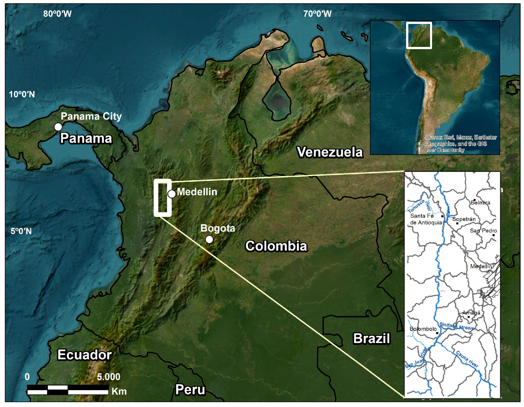
The study area is located in north-western Colombia, in sectors of the Central and Western Andes Cordillera (
Figure 1). The region is composed of igneous, metamorphic and sedimentary rocks related by a fault system, mainly north–south (
Figure 2). In addition, there is an intense weathering, typical of a tropical area, with soil formation up to 20 m deep.
1.1. Geological Setting
The Colombian Andes Cordillera is divided into three mountain ranges: The Eastern, Central and Western Cordilleras. The study area is represented by three elongated belts in a N–S direction on the northwestern edge of Central Cordillera and a fourth belt on the eastern edge of the Western Cordillera. The belts are regionally bounded by the Silvia–Pijao, San Jerónimo and Cauca–Almaguer faults in the sense of [
12] (
Figure 2), and are described from east to west as follows:
Figure 2.
Distribution of lithostratigraphic units in the surroundings of Medellín. Modified from [
13,
14,
15]. Units: 1—Migmatites and gneisses, 2—Caldas Amphibolite, 3—Medellín Ultrabasic, 4—Amphibolite and amphibolic gneisses, 5—Cajamarca Complex, 5b—Arquía Complex, 6—Pueblito Diorite, 7—Altavista Stock, 8—Sabanalarga Batholith, 9—Antioqueño Batholith, 10—Amagá Stock, 11—Quebradagrande Complex, 12—Cañasgordas Group (Barroso Basalts), 13—Combia Formation, 13b—Hypoabyssal rocks, 14—Cañasgordas Group (Sedimentary Member), 15—Amagá Formation, 16—Quaternary Deposits. Blue line: river; discontinuous double line: road.
1.1.1. Belt to the East of the Silvia–Pijao Fault: Medium and High-Grade Metamorphic Rocks with Cretaceous Magmatism
Migmatites and gneisses: Feldspathic quartz gneisses and granofels with biotite interspersed with biotite gneisses, often with sillimanite. These rocks have stromatic, folded, phlebitic and augen migmatitic structures [
16]. The unit is characterized by a profound alteration and, generally, develops several meters of light purple saprolite with ochre, red and white spots that mark the original foliation of the rock [
16].
Caldas Amphibolite: The Caldas amphibole schists consist primarily of amphibole, plagioclase and porphyroblastic garnet concentrated in layers, with subordinate quartz and biotite. These rocks have minerals strongly oriented in the S1 foliation. Intercalated schist layers made of biotite–staurolite are common and exhibit abrupt contacts [
17].
Medellín Ultrabasic: This unit, called “Medellín Dunite”, is an ultramafic body of the Central Cordillera of Colombia and it constitutes a fragment of oceanic lithospheric mantle formed at a back–arc basin incipient arc scenario emplaced onto the western continental margin of Pangaea during the Triassic period. This body has been classically defined, and is still considered, as being mainly of dunite composition [
18].
Amphibolite and amphibolic gneisses: Rocks with gneissic to schist structure, and locally massive to banded. Grain size varies from fine to medium. The predominant colour is black mottled with white with a dark greenish tint by uralitization and chloritization of the hornblende and foliation defined by the flat orientation of the hornblende [
16].
Cajamarca Complex: This unit is composed of metasedimentary and metabasic rocks. Its formation is attributed to a Permian subduction zone, volcanic arc magmatism, opening and closing of basins and accretion of terrenes. The shists, metasedimentary rocks, are mainly formed by quartz, muscovite, biotite, graphite, andalusite and as accessory minerals titanite and zircon; the metabasics rocks are composed of epidote, actinolite, chlorite, hornblende and plagioclase [
19].
Altavista Stock: Two different facies are recognized in the Altavista Stock; one facies has a predominantly medium-grained granodioritic composition represented by andesine plagioclase, quartz, K–feldspar, hornblende and biotite, with accessory minerals including apatite, zircon, titanite and opaque minerals [
20]. A second and more mafic diorite facies commonly found as enclaves within the felsic facies is characterized by intermediate plagioclase, quartz, amphibole and biotite [
20].
Antioqueno Batholith: An intrusive body consisting of tonalite and granodiorite and, occasionally, quartzodiorite and diorite. Although much of the surface is deeply weathered, some outcrops can be seen in the road cuts. In general, it presents as a massive, holocrystalline, medium- to coarse-grained phaneritic igneous rock [
21]. The rock is composed of quartz, plagioclase, potassium feldspar, biotite and amphibole crystals, with traces of epidote, chlorite and sphene [
21].
1.1.2. Belt between the Silvia–Pijao Fault and the San Jerónimo Fault: Cretaceous Sedimentary and Volcanic Rocks
Quebradagrande Complex: Albian –Aptian volcanic type basalts and andesites, and sedimentary rocks of oceanic affinity that outcrops in a highly deformed zone where spatial relationships are difficult to unravel. Berriasian–Aptian sediments that display continental to shallow marine sedimentary facies and mafic and ultramafic plutonic rocks are associated with the Quebradagrande Complex [
22].
1.1.3. Belt between the San Jeronimo Fault and the Cauca–Almaguer Fault: Half-Grade Metamorphic Rocks, Presence of Granodiorites and Ultramafic Rocks from the Jurassic and an Oligocene–Miocene Sedimentary Basin
Aquia Complex: Sericite quartz schists, amphibolic schists, garnet amphibolite, actinolite schists, graphite–muscovite–quartz schists, serpentinites and rocks associated with medium-pressure metamorphism [
23]. These lithotypes are interpreted as igneous and sedimentary rocks subjected to different P–T conditions. The quartz–actinolite schist unit with clinozoisite–zoisite and epidote represent between 50% and 60% of the area [
23].
Pueblito Diorite: Lithology is diorite and, locally, pegmatitic gabbro. The predominant composition is dioritic with amphibole as the predominant mafic and saussuritized amphibolic gabbros as boundary facies both east and west of the main body [
24].
Amagá Stock: The predominant rock is massive, granular to porphyry, medium to coarse-grained, pink to light grey mottled in colour, with black biotite. The texture is granular hypomorphic and the composition varies between quartz–monzonite and granodiorite [
25]. The plagioclase is of composition An20-32, with abundant inclusions of apatite and biotite. The biotite forms nests of reddish-brown idiomorphic laminae with zircon inclusions, with a strong pleochromic halo [
25].
Amagá Formation: Siliciclastic rocks such as lithoarenites and siltstones with coal mantles associated with continental fluvial sequences deposited in the Late Oligocene and Late Miocene under the influence of a transtentional tectonic component (pull-apart) in the Cauca depression [
26]. The Amagá Formation represents environments associated with braided rivers and meandering rivers and is subdivided into two units. The Lower Member is composed mainly of poorly selected quartz conglomerates, well-selected sublithoarenites with high quartz contents, massive greyish silts and coal mantles. The upper limb is composed of lithic wakes, feldspathic lithoarenites and greenish and reddish silts [
26]. Lithostratigraphy of the Amagá Formation can see in
Figure 3.
Combia Formation: This unit has a total thickness of 193 m and comprises 34 layers of welded tuff, pyroclastic and agglomerate breccia, lapilli tuff breccia, basaltic lava flows and scoria fall/flow deposits (
Figure 4) [
28]. The layers are characterized by a tabular geometry. The bottom of the stratigraphic sequence is mainly characterized by lava flows and welded tuff, whereas the top of the sequence mainly consists of coarse- to very coarse-grained pyroclastic flows [
28].
1.1.4. Belt West of the Cauca–Almaguer Fault: Volcano Sedimentary Rocks and Jurassic Magmatism
Cañasgordas Group (Barroso Basalts): This unit corresponds to a volcano-sedimentary unit made up of basalts and andesites with porphyry and tonsil textures, together with agglomerates, tuffs and packages of marine sedimentites intercalated and discordant on volcanic rocks [
29]. The basalts and andesites of the Barroso Formation have a porphyritic texture with phenocrystals of plagioclase and clinopyroxene, in a microcrystalline-to-microlytic hyalocrystalline matrix [
29].
Cañasgordas Group (Sedimentary Member): A sequence of more than 3000 m thick flysch-like sedimentary rocks, folded and faulted, which can be interpreted in terms of proximal turbidite facies. Towards the top, there are intercalations of siltstone and limestone that correspond to distal turbidites [
25]. To the east of the sequence, siltstones and claystones predominate, with interspersed banks of grawacas and locally powerful banks of conglomerate [
25].
Sabanalarga Batholith: Now described as Santa Fe Batholith, this unit comprises gabbros, tonalites and quartzdiorites and diorites. In some instances, gabbros show an increase in percentage of amphibole and can be classified as hornblendites. These lithological types show complex field relations. The most abundant rocks are tonalite [
30].
Unconsolidated deposits: The largest recent Quaternary alluvial zones are found throughout the study area over the four belts described. These deposits correspond to alluvial terraces, floodplains and water stream channels. The alluvial deposits are related to the Cauca and San Juan rivers and a large number of small rivers. In addition, there are large alluvial areas on which the towns of the metropolitan area of Medellín and Santa Fe de Antioquia are built. The thickness of the alluvial zones is highly variable, and in the Aburrá Valley, Medellín City, it can reach 200 m [
25]. These deposits are composed of fragments of different lithologies, poorly selected and without stratification. However, well-selected horizons can be observed in some alluvium that are elevated with respect to the current level of the rivers [
25].
2. Materials and Methods
The key to mapping potential sources of aggregates is an understanding of the geology of the region, which includes Quaternary geology for sand and gravel deposits, stratigraphy, the origin and geological history of the region for crushed stone and weathering or alteration of sand and gravel deposits or potential sources of rock massifs for crushed stone [
31]. The identification and classification of lithostratigraphic units in the surrounding area of Medellín for the use of sands and gravels is built based on the lithological distribution, physical quality and chemical quality of the rocks.
A total of 43 samples, 50 kg each, were taken from the lithostratigraphic units of the study area. The location of the samples on the geological map can be seen in
File S1. Physical tests and chemical analyses were carried out for the regional mapping of potential materials for natural aggregates (see
Table 1) with the respective international standards (
Table 2). The list of analyses carried out on each sample can be found in
File S2.
The description of the rocks in the field was made based on the concepts of weathering profile of a rocky massif [
43], degree of fracturing of a massif [
44], degree of strength of a rock [
44] and the texture or degree of roughness or irregularity of the surface of an aggregate particle [
45].
Physical quality was determined based on the concepts of [
46], as follows:
Satisfactory: Hard to firm materials, relatively free of fractures and in shapes other than flakes; the absorption by capillarity meets specifications, and the surface texture is relatively rough.
Acceptable: Materials exhibit one or two of the following characteristics: firm to friable; moderately fractured; absorption of small to moderate capillarity; flat or flake; relatively soft and waterproof surface.
Poor: Materials exhibit one or more of the following characteristics: friable to powdery; highly fractured, absorption by moderate to high capillarity; marked volume change when wetting and drying; combination of three or more qualities of the “acceptable” type.
The limits for assessing the parameters have been taken from the specifications indicated in the Colombian Technical Standard NTC 174 (ASTM C33 [
32])
Chemical quality was determined based on the concepts of [
46], as follows:
Innocuous: Materials do not contain constituents that can chemically react in a meaningful way with constituents in the atmosphere, water or with Portland cement concrete when inside concrete or mortar under ordinary conditions.
Deleterious: Materials contain one or more constituents in significant proportion and are known to react chemically under ordinary conditions in Portland cement concrete or mortar in such a way as to produce a significant change in volume, interfere with the normal course of Portland cement hydration or provide substances that could produce deleterious effects on concrete or mortar.
These parameters have been corroborated or distorted, in a regional way, with physical and chemical tests on samples of material from the rock unit and with the special regional distribution, such as extensive weathering or shearing of the rocks, to give a regional vision of their characteristics.
The process included the following steps: (a) Synthesis of studies carried out in the region by state institutions, universities, regional corporations and private entities that bring together private companies in the construction materials sector; (b) Collection of lithological information in quarries and field trips with data collection and sampling of materials in 43 sites (
File S1)—each sample weighed 50 kg; (c) Performing physical tests and chemical analysis on material samples; (d) Storing information and results in a geodatabase for ArcGis; (e) Interpreting results, mapping in ArcGis, discussion and conclusions.
The standardization of the materials used in the construction of roads in Medellín are determined by the Colombian Institute of Technical Standards (ICONTEC) and the National Institute of Roads of Colombia (INVIAS).
The preliminary assessment of the physical quality of samples collected in the field was carried out based on granulometry tests with ASTM sieves, Sieve Pass Value # 200, Apparent weight, absorption, Los Angeles Test for large-size coarse aggregate and clay lumps and friable particle. Testing for lightweight material, such as coal, lignite, chert or shale, was performed. However, it is necessary to say that the standards related to this test (ASTM—C123 [
47],) have been withdrawn in the USA and Spain, respectively. A lithological characterization was performed by the 50-grains method [
48]. Roundness has been estimated by visual comparison with standards [
49]. The shape has been determined by the measurement of the dimensions long (A), intermediate (B) and short (C), with A > B > C [
50].
Assessment of the chemical quality of the materials was made based on the tests Alkali reactivity—silica, presence of sulphates (SO4) and presence of organic impurities (Fe2O3).
The project did not perform chloride tests. Because some aggregates may contain chlorides that have an impact on the durability of concrete, it is recommended to add this test in future aggregate exploration campaigns.
3. Results
The determination of the physical and chemical quality of the lithostratigraphic units exposed in the western sector of Medellín has made it possible to identify and assess areas with a potential for sand and gravel in unconsolidated deposits, stratified rocks, unconsolidated deposits and deposits in rocky massifs. Likewise, areas with a potential for sands and gravels have been identified from crushed rock in the lithostratigraphic units composed of igneous rocks and metamorphic rocks, as described below.
3.1. Sources in Unconsolidated Deposits
Sources distributed in the quaternary deposits are associated with the main streams of water in the area and correspond to alluvial terraces, floodplains and current channels (
Figure 5). These deposits have been differentiated as follows: (a) Sector of the Aburrá Valley with alluvial terraces related to the Medellín River in which an extensive exploitation of sands and gravels is made; (b) Sector of San Pedro–Belmira with alluvial terraces associated with the Chico River in the municipalities of Belmira and San Pedro; (c) Sector of Santa Fé de Antioquia–Sopetrán with alluvial terraces and floodplains related to the Aurrá and Tonusco rivers, and to the La Sopetrana and La Seca streams; (d) Bolombolo Sector with extensive floodplains on the banks of the Sinifaná stream and the San Juan and Cauca rivers.
The samples taken in these sectors were analysed by the 50-grains method with sizes between 19.5 and 40 mm to determine the lithology, angularity and shape.
Table 3 shows how the sector of Belmira contains a large number of amphiboles, the sector of Amagá is rich in quartzites and the sectors of Santa Fe de Antioquia—Sopetrán and Bolombolo are composed mainly of basalt-andesites, porphyry andesites and some metamorphic rocks and intrusive igneous rocks.
Unconsolidated and stratified deposits show a degree of roundness, with a predominance of rounded and subrounded edges (
Table 4). These deposits have a granulometric gradation directed to the right of the required range (
Figure 6) and contain flat particles with a maximum of 14%, a value lower than the permissible limit of 25% in the respective local standard (
Figure 7).
The physical tests carried out on sands and gravels of the unconsolidated deposits show important values with respect to the requirements of the Colombian NTC and INVIAS standards (
Table 5).
3.2. Sources in Stratified Rocks
This corresponds to the levels of conglomerates and sandstones of the Combia and Amagá Formations that present strong weathering and release of particles with high potential for use as sands and gravels (
Figure 8).
The sedimentary member of the Combia Formation is a sequence of thick levels of conglomerates, poorly cemented, separated by thin to medium layers of medium to fine grained sandstones, sometimes conglomeratic and cream to reddish claystone. The conglomerate contains rounded to sub-rounded edges of porphyry rocks, sandstone and claystone in a dirty sandy matrix, high in fine quartz grains. The sandstone is quartz with some sedimentary lithics. Chemical analyses to detect alkali–silica reactivity made in the 1982 sample gave a negative result (
Table 6):
The Amagá Formation is a unit composed of polymeric conglomerates with edges of metamorphic rocks, diorites, black chert and milky quartz, conglomeratic sandstones, grain decreasing towards the upper levels and some layers of sandy claystone or clay sandstone, interspersed with sandstone banks.
The physical tests carried out on the sands and gravels of the stratified deposits show the location of the results with respect to the requirements. (
Table 7).
3.3. Sources in Sandy Massifs
It is possible to find deposits with sand-sized material located at the level of strong weathering of the weathering profile of the granodiorite of the Stock of Amagá, granite of the La Miel Gneiss and in granodiorites and tonalites of the Antioquia Batholith (
Figure 9).
Figure 10 and
Table 8 show the results of tests made to material from deposits of sandy massifs and their location according to the requirements of the Colombian NTC and INVIAS standards.
3.4. Sources in Igneous Rocks
Materials originating from intrusive, hypabyssal or volcanic magmatism occur abundantly in the area and have been identified as follows (
Figure 11):
3.4.1. Satisfactory Material—Deleterious AS (Alkali–Silica)
Rocks with the results of physical tests with values within the normativity and satisfactory type characteristics (
Table 9): The presence of siliceous minerals gives it a potential reactive character with cement alkalis. In addition, the presence of micas enhances the increase in flat particles (
Table 10). The rocks of this group correspond to porphyry andesites, hornblendic andesites, porphyritic augitic andesites and dacitic porphyry of the porphyry hypabyssal rocks.
3.4.2. Acceptable Material—Deleterious AS (Alkali–Silica)
Rocks composed of minerals rich in potentially reactive silica (
Table 9): This group is composed of basalts and diabase, andesite and gaps of the Basalt units of Barroso, Quebradagrande Complex and Combia Formation.
3.4.3. Acceptable Material—Deleterious by Light Particles
Rocks with acceptable physical quality and deleterious chemical quality due to the presence of light particles: Rocky materials that correspond to diorites, tonalites and dunites of the units Antioquia Batholith, Altavista Stock, Cambumbia Stock, Heliconia Diorite, Pueblito Diorite, Sabanalarga Batholith, Ebéjico Ultramafic and Medellín Dunite.
3.4.4. Poor Material—Deleterious by Light Particles
The deleterious chemical quality is determined by the presence of micas and the rocks correspond to the Amagá Stock.
3.4.5. Poor Material—Innocuous
Group formed by basic rocks of the Gabbro de Romeral and Hispania Gabbro.
3.5. Sources in Metamorphic Rocks
These rocks are widely distributed in the area and their physical and chemical characterization allows for the following classification (
Figure 12).
3.5.1. Acceptable Material—Deleterious AS-Pl (Alkali–Silica, Light Particles)
Rocky materials with a potential to the alkali–silica reaction (
Table 11) and the presence of light particles. They are rocks of the Palmitas Gneiss and El Retiro granulites and migmatites (
Table 12).
3.5.2. Poor Material—Deleterious PL (Light Particles)
This group is composed of the Cajamarca Complex and Arquía Complex.
4. Discussion
This paper presents a thematic cartography of aggregates, such as sands and gravels, aimed at their use in concrete, mainly around the city of Medellín, Western Colombia (
Figure 13). Its use is also extensive, very importantly, in other towns and intermediate sites where infrastructure works are required.
The materials with the potential to contain sand and gravel have been characterized into three groups: unconsolidated deposits, stratified deposits and rocky massif deposits. The unconsolidated deposits correspond to alluvial materials on terraces or in riverbeds and are associated with the Cauca, San Juan and Medellín rivers. Other deposits of unbound material are associated with the higher parts of the basins of these rivers.
The tests carried out in several sites of the extensive deposits of the Santa Fe de Antioquia–Sopetrán Sector present values that comply with Colombian regulations for the manufacture of Portland cement concrete. These materials have a granulometry that conforms to the Fuller & Thompson curves, values of apparent specific weight and absorption adjusted to the norm, low abrasion wear according to the test of the Los Angeles Machine and low content of clay lumps and friable particles.
In the Bolombolo sector, at the mouths of the San Juan River and the Quebrada Sinifaná, there are deposits of sand and gravel with good specifications regarding the material that passes sieve number 200, absorption and apparent specific weight. Abrasion wear is low according to the Los Angeles Machine test and the content of clay lumps and friable particles is less than the maximum allowed; therefore, they are considered as good materials for the manufacture of concrete and rolling layers.
Some alluvial material deposits associated with the Cauca and San Juan rivers, in the Bolombolo sector, contain a significant amount of sand material. This material is extracted and taken to Medellín, where it is used as a masonry material. The fine sands of this sector have contents of light particles higher than that allowed for use as fine sand in masonry, which would require special processing to achieve their elimination and subsequent use.
The San Pedro–Belmira sector has several alluvial terrace deposits located along the Chico River that contain significant amounts of sand and gravel. These materials represent the main source of sand and gravel for this region. The lithological composition corresponds almost entirely to amphibolite material with rounded and subrounded shapes. Tests on a sample of these deposits present accepted values for the specifications of material that passes mesh 200, apparent specific weight and absorption. Abrasion wear on the Los Angeles Machine is acceptable, although it is superior to the other materials tested in other alluviums of different compositions. The content of clay lumps and friable particles is below the maximum allowed.
The Amagá Formation has a lithological composition, from conglomerates and conglomeratic sands to sands, silts and clays. The lithological composition of materials larger than sand is rich in siliceous material (quartz and chert), which could be considered for the possible alkali–silica reaction with Portland cement concrete. Results of alkali–silica reactivity in the rocks of the Amagá Formation could not be achieved in this research. It is very important to consider this chemical analysis in the Amagá Formation during future aggregate exploration campaigns for concrete. The results of the tests present percentages of material that pass the sieve No 200 at a higher value than allowed; the weight losses in the Los Angeles Machine are at the limit of what is allowed and are far from the granulometric specifications.
The Combia Formation has rock levels that could provide granular material such as sand and gravel in some cases. This unit is composed of rounded to sub-rounded edges of porphyry rocks, and of sandstones and clay stones in a sandy matrix rich in quartz. The tests indicate an adjustment close to a Fuller granulometric strip and a homogeneous size distribution, and although the percentage of material that passes the sieve number 200 is higher than allowed, it meets the requirements of wear on the Los Angeles Machine, clay lumps and friable particles. The alkali–silica trial gave a negative result. The Combia Formation contains edges of andesite, which has amorphous silica which could react with cement alkalis.
In the rocky units, four divisions have been differentiated according to the combination of the results in the physical tests and chemical analysis, as follows: (a) Satisfactory materials—deleterious by alkali–silica (hypabyssal rocks); (b) Acceptable—deleterious by alkali–silica (Barroso basalts, volcanic section of the Quebradagrande Complex and the volcanic section of the Combia Formation); (c) Acceptable—deleterious by light particles (Antioquia Batholith, Altavista Stock, Cambumbia Stock, Heliconia Diorite, Pueblito Diorite, Sabanalarga Batholith, Ebéjico Ultramafic and Medellín Dunite); (d) Poor—innocuous (Romeral Gabbro and Hispania Gabbro).
Potential sources for crushed stone from metamorphic rocks contain materials with acceptable quality—deleterious from the alkali–silica reaction and light particles—and materials with poor quality—deleterious by light particles. The first group includes the rocks of the Palmitas Gneiss and El Retiro granulites and migmatites, and the second group, the Cajamarca Complex and Arquía Complex, have a planar structure that could involve fragility.
The analysis made for the rocks with a potential to be used as crushed stone indicates that all the rocks have a specific weight between 2.06 and 2.95 g/cm3, with the exception of rock samples from Romeral Gabbro, Hispania Gabbro, Medellín Amphibolite, Sucre Amphibolite, Barroso Basalts and Pueblito Diorite. Absorption values indicate that all sampled materials meet the required specification. All materials have an absorption of less than 1%, with the exception of andesitic porphyries, basalts of the Combia Formation, Amagá Stock, Palmitas Gneiss and El Retiro Gneiss, which have a value between 1.0 and 2.4 g/cm3.
The Los Angeles Test allows one to separate several groups, as follows: (a) values between 5 and 20% for volcanic rocks of the Barroso Basalts and Quebradagrande Complex, Andesitic porphyries, diorites of Altavista, Pueblito and Sabanalarga, ultramafic rocks in Medellín, Palmitas Gneiss and Medellín Amphibolite; (b) Values between 20 and 35% for the rocks of the Antioquia Batholith, Hispania Gabbro, Retiro Gneiss, quartzites of the Cajamarca Complex and hornfels in this complex; (c) Values greater than 40% obtained in the Medellín Amphibolite, Sucre Amphibolite and Amagá Stock.
5. Conclusions
The present work of aggregate exploration in the surrounding area of Medellín, Colombia, has allowed us to obtain a cartography of potential units of sand and gravels for the construction industry, with a preliminary regional characterization of their physical and chemical parameters.
Materials located in unconsolidated deposits, such as alluvial and terraces, show good results in the physical and chemical tests. In local exploration campaigns, the silica–alkali reactivity test must be performed, especially when the lithology contains quartz material.
Stratified rocks, such as sandstones and conglomerates, can be used as raw material for aggregates, with subsequent processing in the plant. These are quartz rocks that did not present positive silica–alkali reactivity in a preliminary way, although this situation must be taken into account in the local definition of resources to understand their behaviour.
The sandy massifs are a source of abundant sand due to their well-developed weathering profiles. Specific gravity meets the requirements, but sieve material 200 (ASTM) and flat, friable particles must be controlled.
Igneous rock units present a variety of materials with good, acceptable and poor conditions to be used as aggregates. In general, intrusive rocks and volcanic rocks show good physical results (LA Test) and good specific gravity, but rocks that have a significant quartz component may be reactive to silica–alkali.
Metamorphic units have a high potential for aggregates when they have a massive or gneiss structure. These rocks have poor potential when they are schist due to the high presence of micas and deformed quartz.
It has been possible to classify the potential of lithostratigraphic units to obtain natural aggregates according to the basic tests of granulometry, apparent weight, absorption, Los Angeles Test and flat and friable particles. In addition, the angularity and shape of the grains in the alluvial and stratified materials were determined. The initial chemical behaviour has been achieved with the analysis of silica reactivity—alkali, presence of sulphates (SO4) and the presence of organic impurities (Fe2O3).
Mapping potential rocks for natural aggregates allows the construction industry to focus the search for raw materials from sand and gravels. This cartography is a basic tool for civil authorities to make decisions regarding territorial planning.


