

Mapping Abandoned Uranium Mine Features Using Worldview-3 Imagery in Portions of Karnes, Atascosa and Live Oak Counties, Texas


Abstract
:1. Introduction
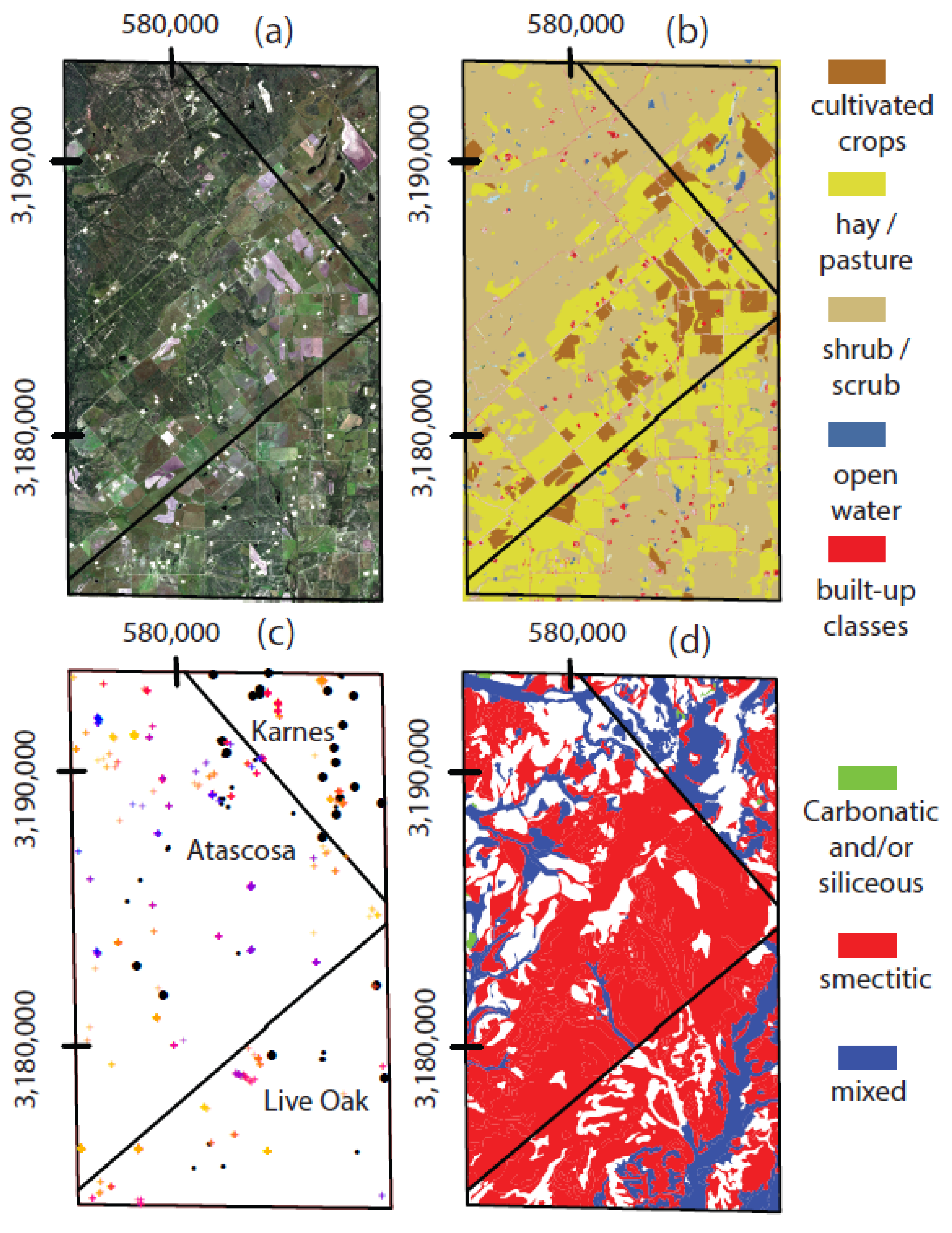
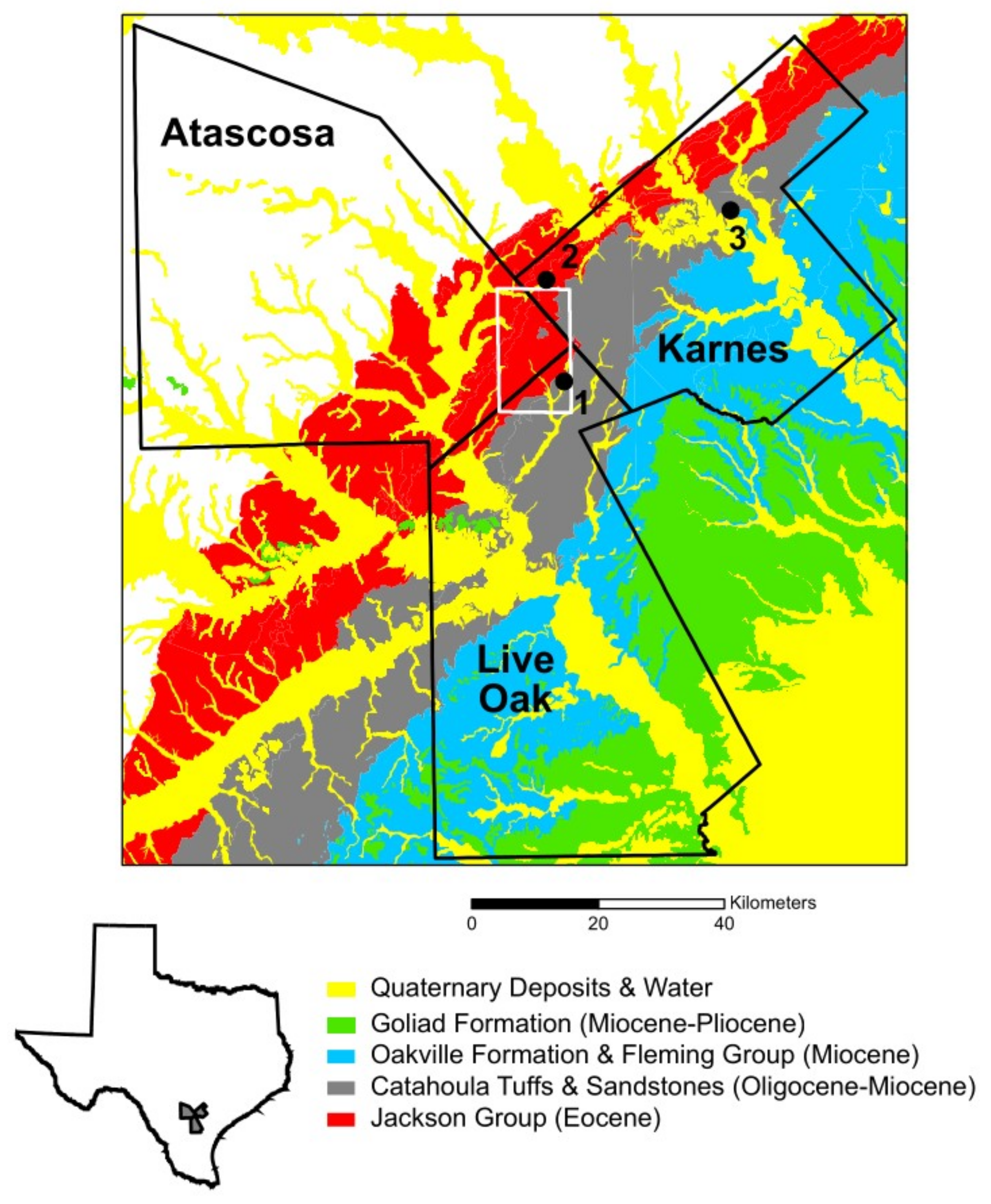
2. Study Area: Location, Geology, Soils, Vegetation, Land-Use and Land-Cover
3. Image Calibration, Pre-Processing, Spectral Analysis and Classification Methods
4. Results
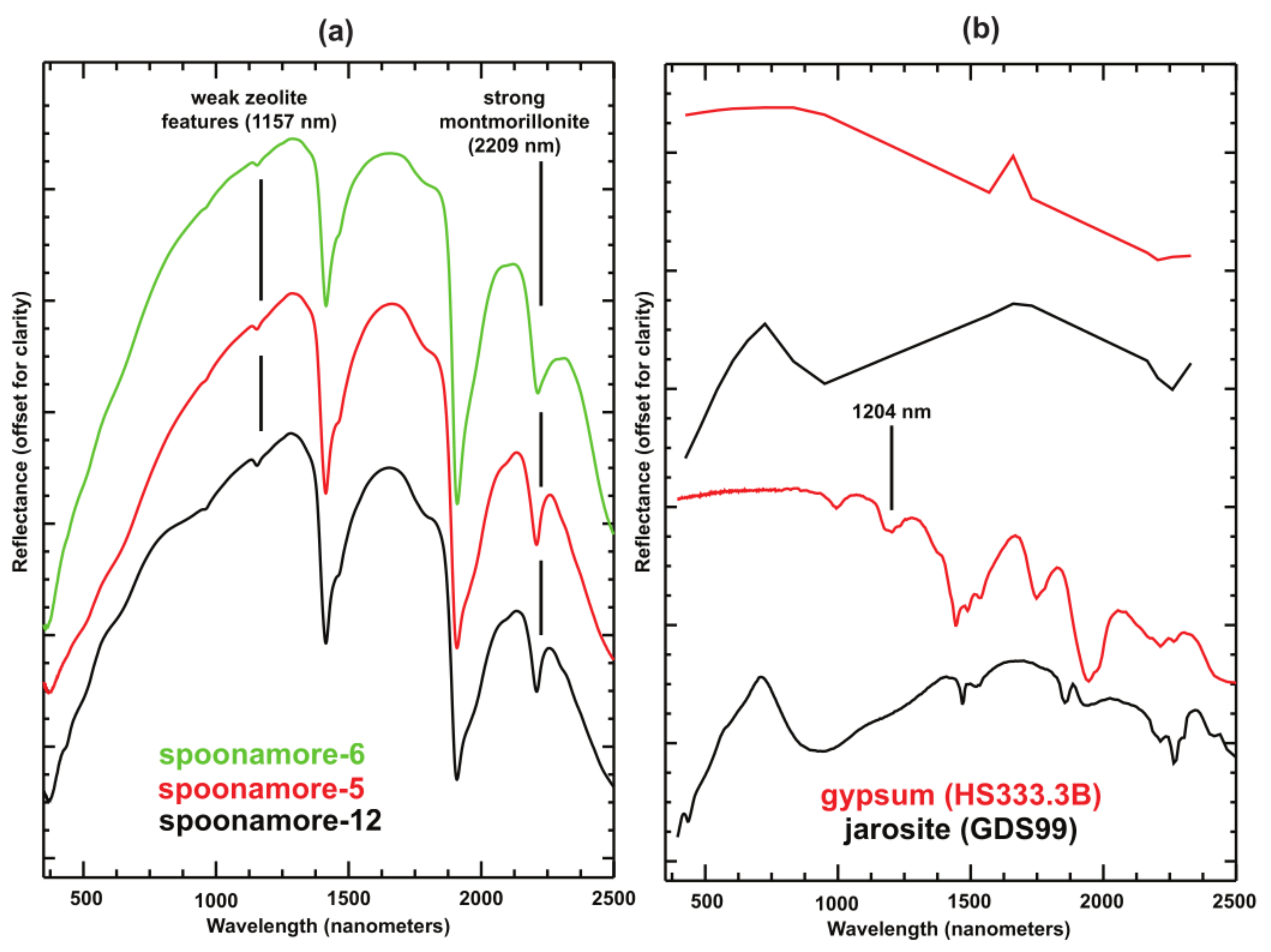
4.1. Compositional Identification of Spectral Endmembers
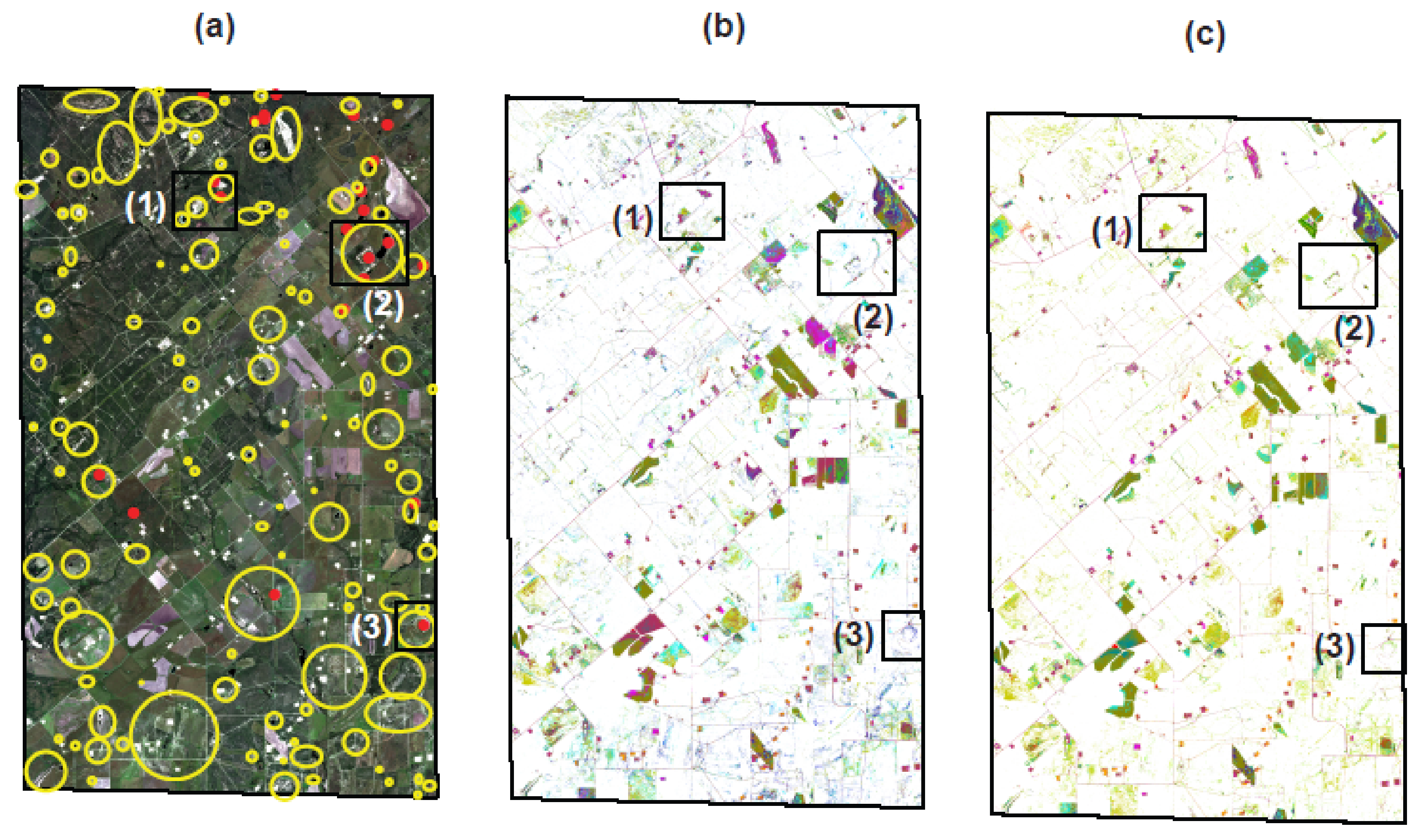
4.2. SAM Initial Classification Results, Class Reduction and Accuracy Assessment
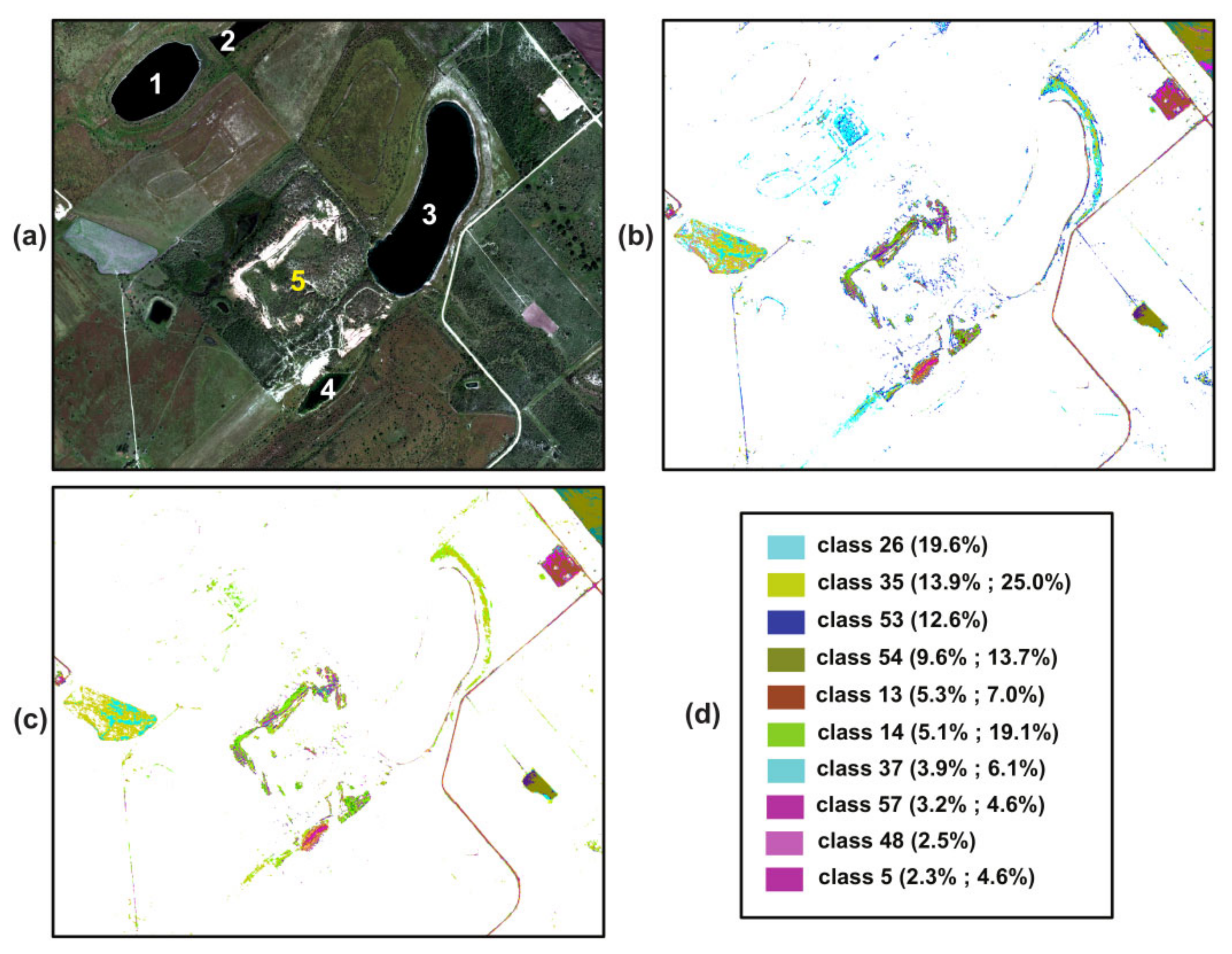
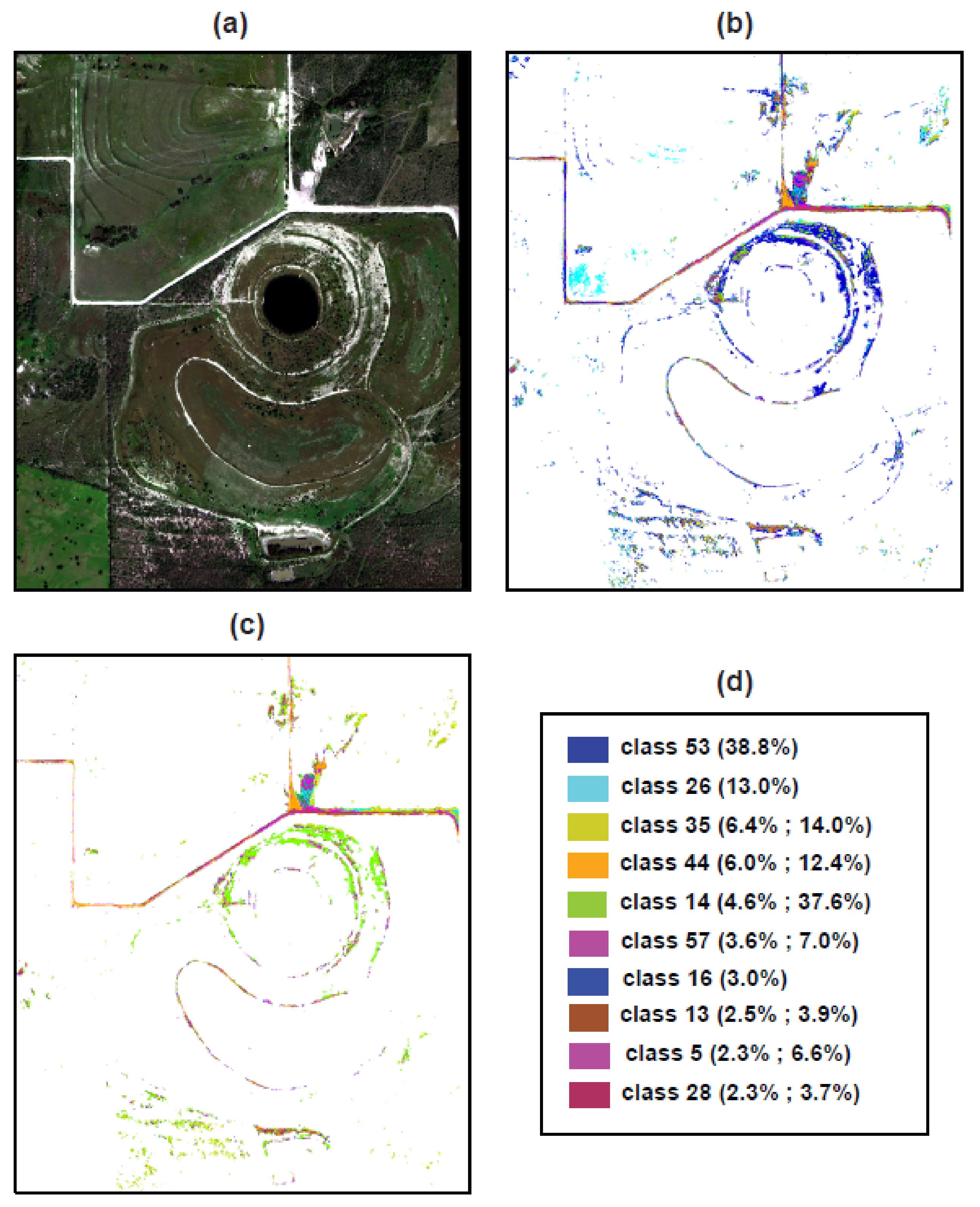
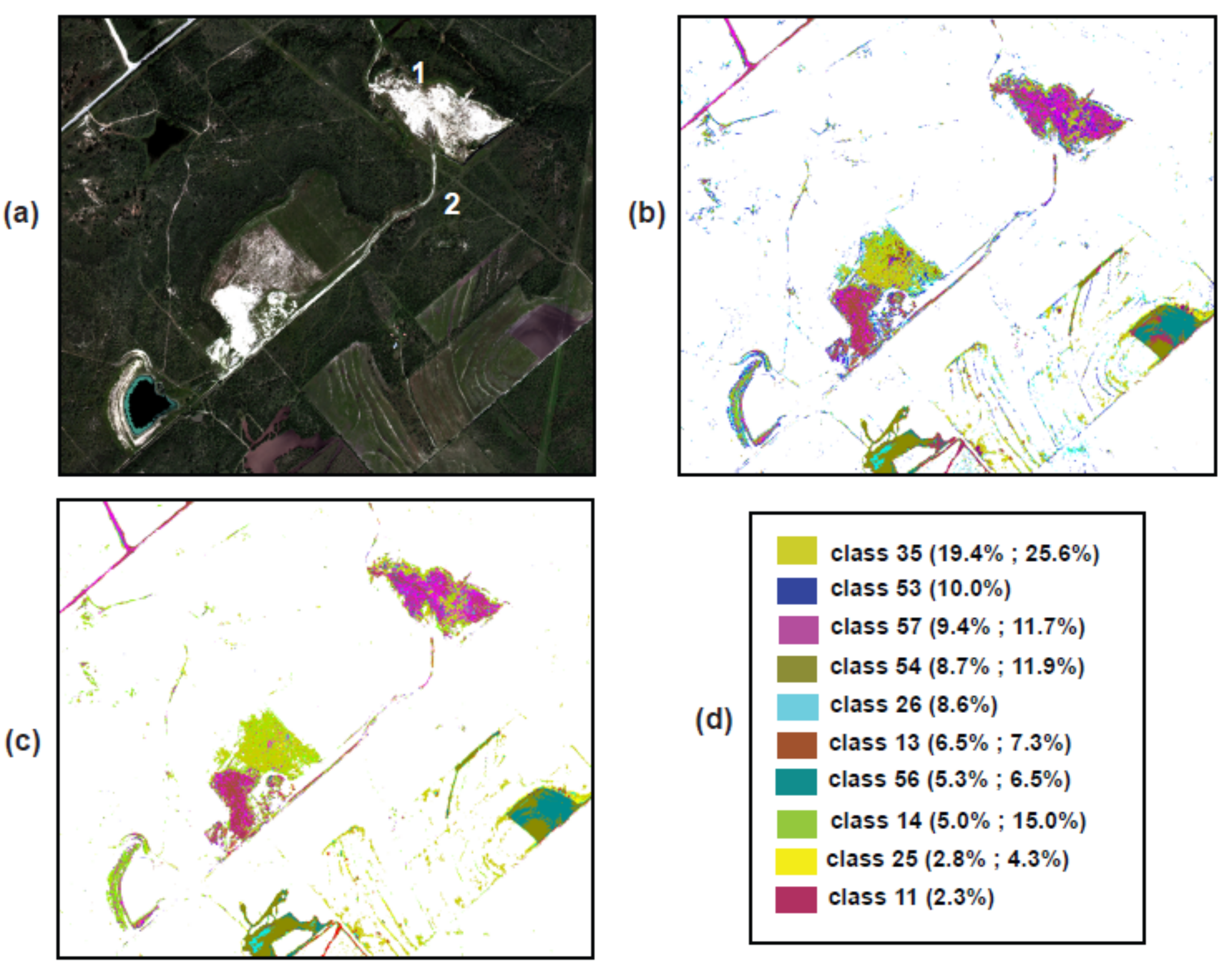
4.3. Detailed Mapping Results: Wright-McCrady, Spoonamore and Garbysch-Thane Example Mine Sites
5. Discussion and Conclusions
Supplementary Materials
Author Contributions
Funding
Data Availability Statement
Acknowledgments
Conflicts of Interest
References
- Hall, S.M.; Mihalasky, M.J.; Tureck, K.R.; Hammarstrom, J.M.; Hannon, M.T. Genetic and grade and tonnage models for sandstone-hosted roll-type uranium deposits, Texas Coastal Plain, USA. Ore Geol. Rev. 2017, 80, 716–753. [Google Scholar] [CrossRef]
- Dahlkamp, F.J. Uranium Deposits of the World–USA and Latin America; Springer: Bonn, Germany, 2010. [Google Scholar]
- Hart, K. Reducing the long-term environmental impact of wastes arising from uranium mining. In Energy, Waste, and the Environment: A Geochemical Perspective; Special Publications, 236; Geological Society: London, UK, 2004; pp. 25–35. [Google Scholar]
- Lottermoser, B.G.; Ashley, P.M. Physical dispersion of radioactive mine waste at the rehabilitated Radium Hill uranium mine site, South Australia. Aust. J. Earth Sci. 2006, 53, 3, 485–499. [Google Scholar] [CrossRef] [Green Version]
- Carvalho, F.P.; Madruga, M.J.; Reis, M.C.; Alves, J.G.; Oliveira, J.M.; Gouveia, J.; Silva, L. Radioactivity in the environment around past radium and uranium mining sites of Portugal. J. Environ. Radioact. 2007, 96, 39–46. [Google Scholar] [CrossRef] [PubMed]
- Yager, D.B.; Fey, D.L.; Chapin, T.P.; Johnson, R.H. New perspectives on a 140-year legacy of mining and abandoned mine cleanup in the San Juan Mountains, Colorado. In Unfolding the Geology of the West. Geological Society of America Field Guide 44; Keller, S.M., Morgan, M.L., Eds.; Geological Society of America: Boulder, CO, USA, 2016; pp. 377–419. [Google Scholar] [CrossRef]
- Brown, T.E.; Waechter, N.B.; Owens, F.; Howeth, I.; Barnes, V.E. Geologic Atlas of Texas, Crystal City-Eagle Pass Sheet; Geologic Atlas of Texas; Map Scale 1:250,000; The University of Texas at Austin, Bureau of Economic Geology: Austin, TX, USA, 1976. [Google Scholar]
- Hubbard, B.E.; Gallegos, T.J.; Stengel, V.; Elliott, B. Visible and Near Infrared (VNIR) and Short Wavelength Infrared (SWIR) Spectra of Select Rock Cores and Waste Material from Nine Uranium Mine Sites in Karnes and Live Oak Counties, Texas; U.S. Geological Survey Data Release; U.S. Geological Survey: Reston, VA, USA, 2023. [CrossRef]
- Vincent, R.K. Uranium exploration with computer-processed Landsat data. Geophysics 1977, 42, 536–541. [Google Scholar] [CrossRef]
- Raines, G.L.; Offield, T.W.; Santos, E.S. Remote-sensing and subsurface definition of facies and structure related to uranium deposits, Powder River Basin, Wyoming. Econ. Geol. 1978, 73, 1706–1723. [Google Scholar] [CrossRef]
- Peters, D.C. Use of airborne multispectral scanner data to map alteration related to roll-front uranium migration. Econ. Geol. 1983, 78, 641–653. [Google Scholar] [CrossRef]
- Stork, C.L.; Smartt, H.A.; Blair, D.S.; Smith, J.L. Systematic Evaluation of Satellite Remote Sensing for Identifying Uranium Mines and Mills; Report SAND2005-7791; U.S. Department of Energy, Sandia National Laboratories: Albuquerque, NM, USA, 2006; 64p.
- Swayze, G.A.; Clark, R.N.; Pearson, R.M.; Livo, K.E. Mapping acid-generating minerals of the California Gulch Superfund Site in Leadville, Colorado using imaging spectroscopy. In Summaries of the 6th Annual JPL Airborne Earth Science Workshop; JPL Publication: Pasadena, CA, USA, 1996; pp. 4–8. [Google Scholar]
- Farrand, W.H.; Harsanyi, J.C. Mapping the distribution of mine tailings in the Coeur d’alene River Valley, Idaho, through the use of a constrained energy minimization technique. Remote Sens. Environ. 1997, 59, 64–76. [Google Scholar] [CrossRef]
- Swayze, G.A.; Smith, K.S.; Clark, R.N.; Sutley, S.J.; Pearson, R.M.; Vance, J.S.; Hugeman, P.L.; Briggs, P.H.; Meier, A.L.; Singleton, M.J.; et al. Using imaging spectroscopy to map acidic mine waste. Environ. Sci. Technol. 2000, 34, 47–54. [Google Scholar] [CrossRef]
- Mars, J.C.; Crowley, J.K. Mapping mine wastes and analyzing areas affected by selenium-rich water runoff in southeast Idaho using AVIRIS imagery and digital elevation data. Remote Sens. Environ. 2003, 84, 422–436. [Google Scholar] [CrossRef]
- Werner, T.T.; Bebbington, A.; Gregory, G. Assessing impacts of mining: Recent contributions from GIS and remote sensing. Extr. Ind. Soc. 2019, 6, 993–1012. [Google Scholar] [CrossRef]
- Yager, D.B.; Johnson, R.H.; Rockwell, B.W.; Caine, J.S. A GIS and statistical approach to identify variables that control water quality in hydrothermally altered and mineralized watersheds, Silverton, Colorado, USA. Environ. Earth Sci. 2013, 70, 1057–1082. [Google Scholar] [CrossRef] [Green Version]
- Horton, J.D.; San Juan, C.A. Prospect- and Mine-Related Features from U.S. Geological Survey 7.5- and 15-Minute Topographic Quadrangle Maps of the United States (ver. 4.0, November 2019); U.S. Geological Survey Data Release; U.S. Geological Survey: Reston, VA, USA, 2019. [CrossRef]
- Fisher, W.L.; Proctor, C.V.; Galloway, W.E.; Nagle, J.S. Depositional systems in the Jackson Group of Texas–Their relationship to oil, gas and uranium. Trans. Gulf Coast Assoc. Geol. Soc. 1970, 20, 234–261. [Google Scholar]
- Dickinson, K.A. Sedimentary depositional environments of uranium and petroleum host rocks of the Jackson Group, South Texas. U.S. Geol. Surv. J. Res. 1976, 4, 615–629. [Google Scholar]
- Eargle, D.H.; Dickinson, K.A.; Davis, B.O. South Texas uranium deposits. Am. Assoc. Pet. Geol. Bull. 1975, 59, 766–779. [Google Scholar]
- Galloway, W.E. Uranium mineralization in a coastal plain fluvial aquifer system: Catahoula Formation, Texas. Econ. Geol. Bull. Soc. Econ. Geol. 1978, 73, 1655–1676. [Google Scholar] [CrossRef]
- Soil Survey Staff. Natural Resources Conservation Service, United States Department of Agriculture. Soil Survey Geographic (SSURGO) Database for Karnes, Atascosa and Live Oak Counties, Texas. 2020. Available online: https://websoilsurvey.nrcs.usda.gov/ (accessed on 3 February 2020).
- Yang, L.; Jin, S.; Danielson, P.; Homer, C.; Gass, L.; Bender, S.M.; Case, A.; Costello, C.; Dewitz, J.; Fry, J.; et al. A new generation of the United States National Land Cover Database: Requirements, research priorities, design, and implementation strategies. ISPRS J. Photogramm. Remote Sens. 2018, 146, 108–123. [Google Scholar] [CrossRef]
- Dittmar, G.W.; Stevens, J.W. Soil Survey of Atascosa County, Texas; U.S. Department of Agriculture, Soil Conservation Service: Washington, DC, USA, 1990; 156p.
- Molina, R. Soil Survey of Karnes County, Texas; U.S. Department of Agriculture, Natural Resource Conservation Service: Washington, DC, USA, 1999; 216p.
- Holland, P.D. Soil Survey of Live Oak County, Texas; U.S. Department of Agriculture, Natural Resource Conservation Service: Washington, DC, USA, 2006; 216p.
- Senkayi, A.L.; Ming, D.W.; Dixon, J.B.; Hossner, L.R. Kaolinite, Opal-CT, and Clinoptilolite in altered tuffs interbedded with lignite in the Jackson Group, Texas. Clays Clay Miner. 1987, 35, 281–290. [Google Scholar] [CrossRef]
- Chalmers, G.R.L.; Bustin, R.M. A multidisciplinary approach in determining the maceral (kerogen type) and mineralogical composition of Upper Cretaceous Eagle Ford Formation: Impact on pore development and pore size distribution. Int. J. Coal Geol. 2017, 171, 93–110. [Google Scholar] [CrossRef]
- Murphy, T.; Brannstrom, C.; Fry, M. Ownership and Spatial Distribution of Eagle Ford Mineral Wealth in Live Oak County, Texas. Prof. Geogr. 2017, 69, 616–628. [Google Scholar] [CrossRef]
- Townsend, P.A.; Helmers, D.P.; Kingdon, C.C.; McNeil, B.E.; de Beurs, K.M.; Eshleman, K.N. Changes in the extent of surface mining and reclamation in the Central Appalachians detected using a 1976–2006 Landsat time series. Remote Sens. Environ. 2009, 113, 62–72. [Google Scholar] [CrossRef]
- Waller, E.K.; Villarreal, M.L.; Poitras, T.B.; Nauman, T.W.; Duniway, M.C. Landsat time series analysis of fractional plant cover changes on abandoned energy development sites. Int. J. Appl. Earth Obs. Geoinf. 2018, 73, 407–419. [Google Scholar] [CrossRef]
- USDA. Texas Cropland Data Layer (CDL), Raster GIS Data, National Agricultural Statistics Service (NASS); USDA-NASS: Washington, DC, USA, 2017. Available online: https://nassgeodata.gmu.edu/CropScape/ (accessed on 3 February 2020).
- McMahan, C.A.; Frye, R.G.; Brown, K.L. The Vegetation Types of Texas Including Cropland; PWD Bulletin 7000-120; Including Oversized Map; Texas Parks and Wildlife Department: Austin, TX, USA, 1984; 41p.
- Elliott, L.F.; Treuer-Kuehn, A.; Blodgett, C.F.; Diane True, C.; German, D.; Diamond, D.D. Ecological Systems of Texas: 391 Mapped Types (2009–2014). Phase 1–6, 10-Meter Resolution Geodatabase, Interpretive Guides, and Technical Type Descriptions. Texas Parks & Wildlife Department and Texas Water Development Board, Austin, Texas. 2014. Documents and Data. Available online: http://www.tpwd.state.tx.us/gis/data/downloads#EMS-T (accessed on 3 February 2020).
- Mars, J.C. Mineral and Lithologic Mapping Capability of WorldView 3 Data at Mountain Pass, California, Using True- and False-Color Composite Images, Band Ratios, and Logical Operator Algorithms. Econ. Geol. 2018, 113, 1587–1601. [Google Scholar] [CrossRef] [Green Version]
- Boardman, J.W.; Kruse, F.A. Analysis of Imaging Spectrometer Data Using N-Dimensional Geometry and a Mixture-Tuned Matched Filtering Approach. IEEE Trans. Geosci. Remote Sens. 2011, 49, 4138–4152. [Google Scholar] [CrossRef] [Green Version]
- Hubbard, B.E.; Crowley, J.K. Mineral mapping on the Chilean–Bolivian Altiplano using co-orbital ALI, ASTER and Hyperion imagery: Data dimensionality issues and solutions. Remote Sens. Environ. 2005, 99, 173–186. [Google Scholar] [CrossRef]
- Adler-Golden, S.; Berk, A.; Bernstein, L.S.; Richtsmeier, S.; Acharya, P.K.; Matthew, M.W.; Anderson, G.P.; Allred, C.L.; Jeong, L.S.; Chetwynd, J.H. FLAASH: A Modtran4 atmospheric correction package for hyperspectral data retrievals and simulations. In Summaries of the 8th Annual JPL Airborne Earth Science Workshop; JPL Publication: Pasadena, CA, USA, 1998; 6p. [Google Scholar]
- Harris Geospatial Solutions, Inc. ENVI USER’S Guide, the Environment for Visualizing Images, ENVI Classic Version 5.6. 2020. Available online: https://www.l3harrisgeospatial.com/ (accessed on 3 February 2020).
- Hively, W.D.; Lamb, B.T.; Daughtry, C.S.T.; Shermeyer, J.; McCarty, G.W.; Quemada, M. Mapping Crop Residue and Tillage Intensity Using WorldView-3 Satellite Shortwave Infrared Residue Indices. Remote Sens. 2018, 10, 1657. [Google Scholar] [CrossRef] [Green Version]
- Green, A.A.; Berman, M.; Switzer, P.; Craig, M.D. A transformation for ordering multispectral data in terms of image quality with implications for noise removal. IEEE Trans. Geosci. Remote Sens. 1988, 26, 65–74. [Google Scholar] [CrossRef] [Green Version]
- Boardman, J.W.; Kruse, F.A.; Green, R.O. Mapping target signatures via partial unmixing of AVIRIS data. In Summaries of the 5th Annual JPL Airborne Earth Science Workshop; JPL Publication: Pasadena, CA, USA, 1995; pp. 23–26. [Google Scholar]
- Clark, R.N. Spectroscopy of rocks and minerals and principles of spectroscopy. In Manual of Remote Sensing; Rencz, A.N., Ed.; John Wiley: New York, NY, USA, 1999; pp. 3–58. [Google Scholar]
- Kokaly, R.F.; Clark, R.N.; Swayze, G.A.; Livo, K.E.; Hoefen, T.M.; Pearson, N.C.; Wise, R.A.; Benzel, W.M.; Lowers, H.A.; Driscoll, R.L.; et al. USGS Spectral Library Version 7; U.S. Geological Survey Data Series 1035; U.S. Geological Survey: Reston, VA, USA, 2017; 29p.
- Kruse, F.A.; Lefkoff, A.B.; Boardman, J.B.; Heidebrecht, K.B.; Shapiro, A.T.; Barloon, P.J.; Goetz, A.F.H. The Spectral Image Processing System (SIPS)–interactive visualization and analysis of imaging spectrometer data. Remote Sens. Environ. 1993, 44, 144–163. [Google Scholar] [CrossRef]
- Crosta, A.P.; Sabine, C.; Taranik, J.V. Hydrothermal Alteration Mapping at Bodie, California, Using AVIRIS Hyperspectral Data. Remote Sens. Environ. 1998, 65, 309–319. [Google Scholar] [CrossRef]
- Clark, R.N.; Swayze, G.A.; Livo, K.E.; Kokaly, R.F.; Sutley, S.J.; Dalton, J.B.; McDougal, R.R.; Gent, C.A. Imaging spectroscopy: Earth and planetary remote sensing with the USGS tetracorder and expert systems. J. Geophys. Res. 2003, 108, 5131–5146. [Google Scholar] [CrossRef]
- Kokaly, R.F. PRISM–Processing Routines in IDL for Spectroscopic Measurements; Open-File Report 2011-1155; U.S. Geological Survey: Reston, VA, USA, 2011; 432p.
- Kokaly, R.F.; King, T.V.V.; Hoefen, T.M. Surface Mineral Maps of Afghanistan Derived from HyMap Imaging Spectrometer Data, Version 2; U.S. Geological Survey Data Series 787; U.S. Geological Survey: Reston, VA, USA, 2013; 29p.
- Waggoner, R.; Brandt, J.; Moffett, L. South Texas Uranium District Abandoned Mine Land Inventory; Railroad Commission of Texas, Surface Mining and Reclamation Division: Austin, TX, USA, 1994; 233p.
- Railroad Commission of Texas (RCTX). Texas Abandoned Mine Land Reclamation Projects; Railroad Commission of Texas, Surface Mining and Reclamation Division: Austin, TX, USA, 2002; 36p. Available online: https://rrc.texas.gov/media/nfebuevw/texasamlprojects.pdf (accessed on 26 April 2023).
- Kruger, G.; Erzinger, J.; Kaufmann, H. Laboratory and airborne reflectance spectroscopic analysis of lignite overburden dumps. J. Geochem. Explor. 1998, 64, 47–65. [Google Scholar] [CrossRef]
- Herbert, B.; Baron, F.; Robin, V.; Lelievre, K.; Dacheux, N.; Szenknect, S.; Mesbah, A.; Pouradier, A.; Jikibayev, R.; Roy, R.; et al. Quantification of coffinite (USiO4) in roll-front uranium deposits using visible to near infrared (Vis-NIR) portable field spectroscopy. J. Geochem. Explor. 2019, 199, 53–59. [Google Scholar] [CrossRef]
- Cloutis, E.A. Spectral reflectance properties of hydrocarbons: Remote sensing implications. Science 1989, 245, 165–168. [Google Scholar] [CrossRef] [Green Version]
- Bomber, B.J.; Ledger, E.B.; Tieh, T.T. Ore petrography of a sedimentary uranium deposit, Live Oak County, Texas. Econ. Geol. 1986, 81, 131–142. [Google Scholar] [CrossRef]
- Crowley, J.K.; Brickey, D.W.; Rowan, L.G. Airborne imaging spectrometer data of the Ruby Mountains, Montana: Mineral discrimination using relative absorption band-depth images. Remote Sens. Environ. 1989, 29, 121–134. [Google Scholar] [CrossRef]
- Breger, I.A.; Deul, M.; Rubinstein, S. Geochemistry and Mineralogy of a Uraniferous Lignite. Econ. Geol. 1955, 50, 206–226. [Google Scholar] [CrossRef]
- Senkayi, A.L.; Dixon, J.B.; Hossner, L.R.; Viani, B.E. Mineralogical transformations during weathering of lignite overburden in East Texas. Clays Clay Miner. 1983, 31, 49–56. [Google Scholar] [CrossRef]
- Jackisch, R.; Lorenz, S.; Zimmermann, R.; Mockel, R.; Gloaguen, R. Drone-Borne Hyperspectral Monitoring of Acid Mine Drainage: An Example from the Sokolov Lignite District. Remote Sens. 2018, 10, 385. [Google Scholar] [CrossRef] [Green Version]
- United States Department of the Interior and United States Department of Agriculture. Surface Operating Standards and Guidelines for Oil and Gas Exploration and Development; BLM/WO/ST-06/021+3071/REV 07; Bureau of Land Management: Denver, CO, USA, 2007; 84p.
- Williams, H.F.L.; Havens, D.L.; Banks, K.E.; Wachal, D.J. Field-based monitoring of sediment runoff from natural gas well sites in Denton County, Texas, USA. Environ. Geol. 2008, 55, 1463–1471. [Google Scholar] [CrossRef]
- Brittingham, M.C.; Maloney, K.O.; Farag, A.M.; Harper, D.D.; Bowen, Z.H. Ecological risks of shale oil and gas development to wildlife, aquatic resources and their habits. Environ. Sci. Technol. 2014, 48, 11034–11047. [Google Scholar] [CrossRef]
- Lillesand, T.M.; Keifer, R.W.; Chipman, J.W. Remote Sensing and Image Interpretation, 6th ed.; Chapter 7; Wiley: New York, NY, USA, 2008; pp. 482–625. [Google Scholar]
- Dickinson, K.A. Geologic Controls of Uranium Deposition, Karnes County, Texas; Open-File Report 76-331; U.S. Geological Survey: Reston, VA, USA, 1976; 15p.
- Eargle, D.H.; Snider, J.L. Stratigraphy of the Uranium-Bearing Rocks of the Karnes County Area, South-Central Texas—A Preliminary Report; Trace Element Investigations Report 488; U.S. Geological Survey: Reston, VA, USA, 1956; 46p.
- Shang, J.; Morris, B.; Howarth, P.; Levesque, J.; Staenz, K.; Neville, B. Mapping mine tailing surface mineralogy using hyperspectral remote sensing. Can. J. Remote Sens. 2009, 35, S126–S141. [Google Scholar] [CrossRef]
- Fernandez-Lozano, J.; Gutierrez-Alonso, G.; Fernandez-Moran, M.A. Using airborne LiDAR sensing technology and aerial orthoimages to unravel roman water supply systems and gold works in NW Spain (Eria valley, Leon). J. Archaeol. Sci. 2015, 53, 356–373. [Google Scholar] [CrossRef]
- Park, S.; Choi, Y. Applications of unmanned aerial vehicles in mining from exploration to reclamation: A review. Minerals 2020, 10, 663. [Google Scholar] [CrossRef]
- Wu, Z.; Snyder, G.; Vadnais, C.; Arora, R.; Babcock, M.; Stensaas, G.; Doucette, P.; Newman, T. User needs for future Landsat missions. Remote Sens. Environ. 2019, 231, 111214. [Google Scholar] [CrossRef]


| Endmember Class # | Spectral Match Angle (Radians) | Spectral Match (Geologic Sample) | 1-Micron MICA Match | 2-Micron MICA Match |
|---|---|---|---|---|
| 33 | 0.058535 | bargmann-1 | goethite.thincoat.singlefeat | montmorillonite_Na_highfit |
| 25 | 0.066616 | |||
| 19 | 0.068115 | |||
| 48 | 0.090795 | |||
| 43 | 0.045664 | bargmann-2 | goethite.thincoat.singlefeat | kaolin.5+smectite.5 |
| 34 | 0.070265 | |||
| 45 | 0.089269 | |||
| 35 | 0.069281 | spoonamore-4 | lignite (nanohematite.singlefeat false positive) | montmorillonite_Na |
| 36 | 0.074693 | |||
| 41 | 0.079308 | |||
| 49 | 0.080826 | |||
| 24 | 0.077495 | spoonamore-5 | goethite.thincoat.singlefeat | montmorillonite_Na_highfit |
| 5 | 0.085778 | |||
| 39 | 0.092893 | |||
| 29 | 0.088401 | spoonamore-6 | Unclassified | montmorillonite_Na |
| 13 | 0.058144 | spoonamore-7 | goethite.thincoat.singlefeat | montmorillonite_Ca |
| 55 | 0.090287 | |||
| 37 | 0.065497 | spoonamore-9 | lignite (hematite.finegr.fe2602 false positive) | Unclassified |
| 30 | 0.085383 | |||
| 52 | 0.096045 | |||
| 54 | 0.073947 | spoonamore-10 | lignite (nanohematite.singlefeat false positive) | Unclassified |
| 40 | 0.07803 | |||
| 58 | 0.079606 | |||
| 11 | 0.08331 | |||
| 50 | 0.085465 | |||
| 44 | 0.053086 | spoonamore-12 | Unclassified | montmorillonite_Na |
| 23 | 0.076721 | |||
| 1 | 0.084202 | spoonamore-13 | lignite (nanohematite.singlefeat false positive) | montmorillonite_Na |
| 28 | 0.044385 | spoonamore-14 | Unclassified | montmorillonite_Na |
| 57 | 0.052872 | spoonamore-27 | Unclassified | chalcedony |
| 22 | 0.069876 | |||
| 14 | 0.081956 | spoonamore-38 | Fe3+_type_1b (Acid_Mine_Dr Assemb1) | montmorillonite_Na_highfit |
| 12 | 0.033884 | winerich-5 | goethite.thincoat.singlefeat | montmorillonite_Na |
| 17 | 0.035235 | |||
| 42 | 0.06012 | |||
| 27 | 0.036447 | winerich-8 | Unclassified | calcite.8+montmorillonite_Ca.2 |
| Endmember Class # | WV3 rbd-1210 nm (Zeolite/Uranium Minerals Index) | Spectral Match (Geologic Sample) | Hyperspectral rbd-1157 nm (Heulandite/Clinoptilolite) |
|---|---|---|---|
| 21 | 2.478887 | unmatched | N/A |
| 32 | 2.344082 | unmatched | N/A |
| 20 | 2.186793 | unmatched | N/A |
| 15 | 2.150885 | unmatched | N/A |
| 2 | 2.147810 | unmatched | N/A |
| 29 | 2.103521 | spoonamore-6 | 2.017605 |
| 8 | 2.053413 | unmatched | N/A |
| 55 | 2.047738 | spoonamore-7 | 2.004085 |
| 5 | 2.044193 | spoonamore-5 | 2.028697 |
| 23 | 2.036904 | spoonamore-12 | 2.035804 |
| 50 | 2.027945 | spoonamore-10 | 2.012043 |
| 56 | 2.012584 | unmatched | N/A |
| 47 | 2.010877 | unmatched | N/A |
| 31 | 2.006367 | unmatched | N/A |
| 58 EMs Full WV3 Scene | 58 EMs Bare/Partially Fallow Fields | 58 EMs Oil/Gas Drill Pads | 58 EMs Bedrock/Mine /Quarry Features | 23 Reduced EMs Full WV3 Scene | |||||
|---|---|---|---|---|---|---|---|---|---|
| Class # | % Mapped | Class # | % Mapped | Class # | % Mapped | Class # | % Mapped | Class # | % Mapped |
| 35 | 17.57 | 54 | 29.95 | 13 | 42.08 | 35 | 16.79 | 35 | 25.04 |
| 54 | 13.25 | 11 | 14.22 | 57 | 20.62 | 26 | 14.59 | 54 | 23.30 |
| 26 | 11.36 | 35 | 13.00 | 44 | 12.28 | 53 | 12.84 | 37 | 10.43 |
| 53 | 7.54 | 37 | 8.43 | 28 | 7.98 | 57 | 8.15 | 14 | 6.85 |
| 11 | 5.77 | 43 | 6.13 | 27 | 6.54 | 14 | 6.74 | 13 | 5.82 |
| 37 | 5.60 | 26 | 5.59 | 19 | 2.34 | 37 | 4.52 | 25 | 5.30 |
| 13 | 4.96 | 58 | 5.57 | 17 | 2.10 | 13 | 4.03 | 57 | 4.66 |
| 58 | 4.05 | 40 | 4.67 | 16 | 0.99 | 36 | 2.86 | 43 | 3.33 |
| 25 | 3.81 | 50 | 2.60 | 37 | 0.60 | 5 | 2.67 | 44 | 2.99 |
| 57 | 3.57 | 56 | 2.48 | 36 | 0.56 | 19 | 2.61 | 56 | 2.66 |
| 43 | 2.72 | 25 | 2.40 | 30 | 0.39 | 58 | 2.47 | 1 | 2.50 |
| 40 | 2.17 | 45 | 1.49 | 29 | 0.33 | 25 | 1.97 | 28 | 1.43 |
| 44 | 1.96 | 48 | 0.72 | 43 | 0.27 | 54 | 1.79 | 5 | 1.24 |
| 28 | 1.21 | 12 | 0.59 | 52 | 0.26 | 48 | 1.37 | 12 | 1.21 |
| 56 | 1.16 | 10 | 0.37 | 31 | 0.24 | 28 | 1.28 | 51 | 0.98 |
| 14 | 1.14 | 53 | 0.33 | 54 | 0.21 | 33 | 1.15 | 27 | 0.87 |
| 50 | 1.05 | 51 | 0.25 | 12 | 0.20 | 44 | 1.14 | 29 | 0.65 |
| 48 | 0.94 | 19 | 0.22 | 26 | 0.20 | 42 | 1.08 | 20 | 0.61 |
| 27 | 0.74 | 42 | 0.20 | 42 | 0.19 | 20 | 1.00 | 32 | 0.10 |
| 33 | 0.69 | 1 | 0.15 | 14 | 0.18 | 49 | 0.83 | 2 | 0.02 |
| 19 | 0.66 | 49 | 0.12 | 53 | 0.15 | 17 | 0.83 | 15 | 0.01 |
| 45 | 0.63 | 36 | 0.12 | 5 | 0.15 | 29 | 0.80 | 21 | 0.01 |
| 5 | 0.60 | 9 | 0.09 | 25 | 0.15 | 39 | 0.75 | 3 | 0.00 |
| Occurrrence or Mine Name | LAT | LONG | COUNTY | OCCTYPE | OPTYPE | WV3 Mapped Classes Using Full 58 Endmembers | WV3 Mapped Classes Using Reduced 23 Endmembers | Comments |
|---|---|---|---|---|---|---|---|---|
| BOSO-HACKNEY 2 | 28.8665 | −98.1473 | Karnes | Deposit | Open Pit | 26, 53, 5, 14 | 14, 5 | Mostly reclaimed |
| BUTLER PIT/BUTLER RANCH | 28.8587 | −98.1157 | Karnes | Deposit | Open Pit | N.A. | N.A. | Fully reclaimed |
| COLONEL WEDDINGTON | 28.8594 | −98.1533 | Karnes | Prospect | N.A. | 26, 51, 53, 35, 29 (plus other outliers) | 51, 35, 14, 5, 29 (plus other outliers) | Mostly reclaimed |
| ESSE-SPOONAMOORE | 28.7332 | −98.1063 | Live Oak | Deposit | Open Pit | 53, 14, 26, 5, 35 (plus other outliers) | 14, 5, 35, 44, 20 (plus other outliers) | Partially reclaimed |
| GARBYSCH-THANE | 28.8447 | −98.1650 | Atascosa | Deposit | Open Pit | 35, 57, 13, 53, 14, 26 (plus other outliers) | 35, 57, 14, 13, 25 (plus other outliers) | Unreclaimed |
| HURT MINE | 28.7712 | −98.1984 | Atascosa | Deposit | Open Pit | 35, 54, 26, 53, 37, 43, 25 (plus other outliers) | 35, 54, 43, 37, 25, 14 (plus other outliers) | Mostly reclaimed |
| KELLNER PIT | 28.8323 | −98.1276 | Karnes | Deposit | Open Pit | 26, 53, 48, 9, 35 (plus other outliers) | 14, 35, 51, 5 (no other outliers) | Mostly reclaimed |
| MARVIN HACKNEY | 28.8600 | −98.1506 | Karnes | Prospect | N.A. | 53, 26, 35, 33, 25 (plus other outliers) | 14, 35, 25, 5, 57 (plus other outliers) | Mostly reclaimed |
| MC-CRADY MINE | 28.8252 | −98.1212 | Karnes | Deposit | Open Pit | 53, 26, 14, 35, 5, 57 (plus other outliers) | 14, 35, 5, 57, 51, 20 (plus other outliers) | Partially reclaimed |
| PFEIL-WEIG MINE | 28.8124 | −98.1284 | Atascosa | Deposit | Open Pit | 26, 53, 35, 5 (plus other outliers) | 14, 35, 5, 20 (plus other outliers) | Mostly reclaimed |
| RICHARD RUDOLF | 28.7411 | −98.1486 | Live Oak | Prospect | N.A. | 53, 26, 35, 25, 57 (plus other outliers) | 14, 35, 25, 57, 37 (plus other outliers) | Mostly reclaimed |
| SOILZ | 28.7636 | −98.1089 | Live Oak | Prospect | N.A. | 26, 35, 53 (plus other outliers) | 35, 14 (plus other outliers) | Mostly reclaimed |
| TOM-RETZLOF | 28.7616 | −98.1887 | Atascosa | Deposit | Open Pit | N.A. | N.A. | Fully reclaimed |
| USGS GP−252_2 | 28.8613 | −98.1507 | Karnes | Prospect | N.A. | N.A. | N.A. | Fully reclaimed |
| USGS GP−252_29 | 28.8407 | −98.1634 | Karnes | Prospect | N.A. | 53, 26, 35, 5 (plus other outliers) | 14, 35, 5, 20 (plus other outliers) | Mostly reclaimed |
| USGS GP−252−4 | 28.8607 | −98.1252 | Karnes | Prospect | N.A. | 54, 58, 37, 11, 25, 35 (plus other outliers) | 54, 37, 1, 35, 25, 43, 56 (plus other outliers) | Mostly reclaimed |
| W. DZUIK UL−1798 | 28.8232 | −98.1058 | Karnes | Deposit | Open Pit | 26, 53, 35 (plus other outliers) | 35, 14, 5 (plus other outliers) | Partially to mostly reclaimed |
| WEDDINGTON-NORTH | 28.842 | −98.1232 | Karnes | Deposit | Open Pit | 26, 53, 35, 5, 48, 57, 14 (plus other outliers) | 14, 35, 5, 57 (plus other outliers) | Mostly reclaimed |
| WEDDINGTON-SOUTH (CONOCO) | 28.8291 | −98.1157 | Karnes | Deposit | Open Pit | 26, 35, 53, 24, 14, 48 (plus other outliers) | 35, 14, 5, 44, 25, 20 (plus other outliers) | Partially to mostly reclaimed |
| WEDDINGTON-SUSQUEHANA | 28.8494 | −98.1198 | Karnes | Deposit | Open Pit | N.A. | N.A. | Fully reclaimed |
| WEDDINGTON-TENNECO | 28.837 | −98.1226 | Karnes | Deposit | Open Pit | 26, 53, 5 (plus other outliers) | 14, 35, 5 (plus other outliers) | Mostly reclaimed |
| WILLIE GABRISH | 28.8667 | −98.1681 | Atascosa | Prospect | N.A. | 35, 53, 26, 25, 58, 14 (plus other outliers) | 35, 25, 14, 37, 57, 1 (plus other outliers) | Unreclaimed to partially reclaimed |
| WRIGHT PIT | 28.82 | −98.1228 | Karnes | Deposit | Open Pit | N.A. | N.A. | Fully reclaimed |
Disclaimer/Publisher’s Note: The statements, opinions and data contained in all publications are solely those of the individual author(s) and contributor(s) and not of MDPI and/or the editor(s). MDPI and/or the editor(s) disclaim responsibility for any injury to people or property resulting from any ideas, methods, instructions or products referred to in the content. |
© 2023 by the authors. Licensee MDPI, Basel, Switzerland. This article is an open access article distributed under the terms and conditions of the Creative Commons Attribution (CC BY) license (https://creativecommons.org/licenses/by/4.0/).
Share and Cite
Hubbard, B.E.; Gallegos, T.J.; Stengel, V. Mapping Abandoned Uranium Mine Features Using Worldview-3 Imagery in Portions of Karnes, Atascosa and Live Oak Counties, Texas. Minerals 2023, 13, 839. https://doi.org/10.3390/min13070839
Hubbard BE, Gallegos TJ, Stengel V. Mapping Abandoned Uranium Mine Features Using Worldview-3 Imagery in Portions of Karnes, Atascosa and Live Oak Counties, Texas. Minerals. 2023; 13(7):839. https://doi.org/10.3390/min13070839
Chicago/Turabian StyleHubbard, Bernard E., Tanya J. Gallegos, and Victoria Stengel. 2023. "Mapping Abandoned Uranium Mine Features Using Worldview-3 Imagery in Portions of Karnes, Atascosa and Live Oak Counties, Texas" Minerals 13, no. 7: 839. https://doi.org/10.3390/min13070839