Review

How Was the Late Neogene Red Clay Formed in the Ordos Plateau (Northwest China)?

by
Xu Lin
1,2,*,
Chengwei Hu
1,
Ruitong Wu
1,
Lishuang Qin
1,
Runzhi Xiang
1,
Zhengyang An
1 and
Hang Lu
1
1
College of Civil Engineering and Architecture, China Three Gorges University, Yichang 443002, China
2
Collaborative Innovation Center for Geo-Hazards and Eco-Environment in Three Gorges Area, China Three Gorges University, Yichang 443002, China
*
Author to whom correspondence should be addressed.
Minerals 2024, 14(6), 537; https://doi.org/10.3390/min14060537
Submission received: 11 April 2024 / Revised: 21 May 2024 / Accepted: 22 May 2024 / Published: 23 May 2024
(This article belongs to the Section Clays and Engineered Mineral Materials)

Abstract

:
Eolian sediments are extensively distributed across the Earth’s surface, and their formation is intricately linked to climate change, tectonic activity, and topographic features. Consequently, the investigation of eolian sediments bears great geological significance. The northwest region of China is renowned for hosting the most extensive and thickest Late Miocene–Pliocene red clay deposits globally. Nonetheless, scholars have yet to reach a consensus regarding the precise formation processes of these red clays. The identification of the source region of the red clays is crucial for comprehending their formation mechanism. The correlation of zircon U-Pb age spectra is a frequently utilized method for determining the provenance of eolian sediments. In this study, we compared the previously published zircon U-Pb ages (n = 12,918) of the Late Miocene–Pliocene red clays in the Ordos Plateau with those from the potential provenance regions (n = 24,280). The analysis, supported by the tectonic and climatic background of the region, revealed that the Late Miocene–Pliocene red clay in the Ordos Plateau originates predominantly from the Yellow and Wei rivers, with a minor contribution from the weathering of bedrock in the western North China Craton. The transport of these detrital materials by the East Asian winter monsoon is impeded by the presence of the Qinling and Taihang Shan, resulting in their deposition on the flat surface of the Ordos Plateau. This development of red clay is consistent with the proximal accumulation model, illustrating how the hydrosphere, atmosphere, and lithosphere interacted to shape the red clay deposits during the Late Miocene and Pliocene periods in the Ordos Plateau.

1. Introduction

Eolian sediments, encompassing deserts, loess, and red clay, cover approximately one-third of the Earth’s surface [1,2]. The distribution of eolian sediments worldwide is influenced by factors such as wind patterns, topography, and the availability of sediment sources [3,4,5,6]. Therefore, unraveling the origins of these eolian sediments holds significant geological significance, as they provide valuable clues about past climate conditions and tectonic activities [7,8]. Northwest China is home to the most extensive and thickest distribution of Neogene red clay globally [9,10,11,12] (Figure 1a). This region serves as an exemplary location for investigating the interconnected relationship between tectonic uplift, climate variations, and the accumulation of aeolian sediments [13]. Previous studies indicate that red clays from the Late Oligocene and Early Miocene exhibit a primarily point pattern concentrated along the western edge of the Ordos Plateau [14,15,16,17,18,19,20,21,22] (Figure 2a,b). However, red clays from the Late Miocene and Pliocene, characterized by a planar pattern, are predominantly found in the eastern region of the Ordos Plateau [9,23,24,25,26,27,28] (Figure 2c,d).
Numerous scholars have proposed diverse theories to explain the formation of red clays from the Ordos Plateau. The water formation theory posits that red clay results from erosional processes on bedrock, which are then transported by seasonal flowing water to lower areas, where they are deposited alongside rivers and lakes [29,30,31]. The aeolian theory suggests that both red clay and the overlying Quaternary loess are the products of aeolian dust deposition [11,14,32]. However, there are differing perspectives on the exact formation processes. Some researchers argue that the Neogene uplift of the northeastern Tibetan Plateau and the Central Asian orogenic belt created a narrow channel effect, leading to the accumulation of near-surface clastic material on the Ordos Plateau under the influence of the East Asian winter monsoon [13]. Alternatively, some researchers emphasize that the Neogene uplift of the Qinling and Taihang Shan resulted in the Ordos Plateau being situated in a rain shadow region, leading to arid climatic conditions [33,34]. Under the influence of the East Asian winter monsoon and geomorphic barriers, clastic sediments accumulated along the northern and western foothills of the Qinling and Taihang Shan, respectively [35,36] (Figure 1b,c). Additionally, some researchers attribute the increase in eolian sediment accumulation in Northwest China during the early Neogene to global cooling [18,37,38]. A connection has been suggested between the uplift of the northeastern Tibetan Plateau, the development of the upper reaches of the Yellow River, and the appearance of Pliocene red clay in the region [12,39,40,41]. However, a comprehensive discussion is needed to determine whether the formation of Late Miocene red clay is associated with the upper reaches of the Yellow River [42]. As outlined in the review, there is a lack of consensus on the mechanism that led to the extensive formation of red clay in the Ordos Plateau during the Late Miocene and Pliocene.
The key to solving the above problem is to determine the provenance of the Late Miocene to Pliocene red clay in the Ordos Plateau. Provenance tracing is a widely used method for determining the origin of eolian sediments [6,43]. It involves conducting in-situ isotope analysis of target minerals within the sediments to compare their resulting isotope ratios and/or age spectra with potential source regions [44]. In the case of red clay, zircon, a common detrital mineral, is particularly useful, as it retains U-Pb age information from the source area even after long-distance transport [38,40,45]. The sedimentary age of Late Miocene and Pliocene red clays in the Ordos Plateau has been well-established through paleomagnetic and paleontological fossil analysis [46]. Extensive documentation of zircon U-Pb age data from these Neogene strata provides valuable spatial provenance information [10,13,18,31,40,41,47,48,49]. Additionally, the evolution of the upper and middle Yellow River and the Wei River during the Neogene has been thoroughly studied [16,50,51,52,53,54,55,56,57,58]. Detailed records of the U-Pb ages of detrital zircons from diluvial fans [49,59,60], deserts [39,61,62,63,64], and sandy lands [61,62,65] in Northwest China have been reported. Therefore, the methodology involved conducting statistical analyses on previously published detrital zircon U-Pb age data from the literature to establish the origin and formation mechanisms of Late Miocene to Pliocene red clay in the Ordos Plateau.

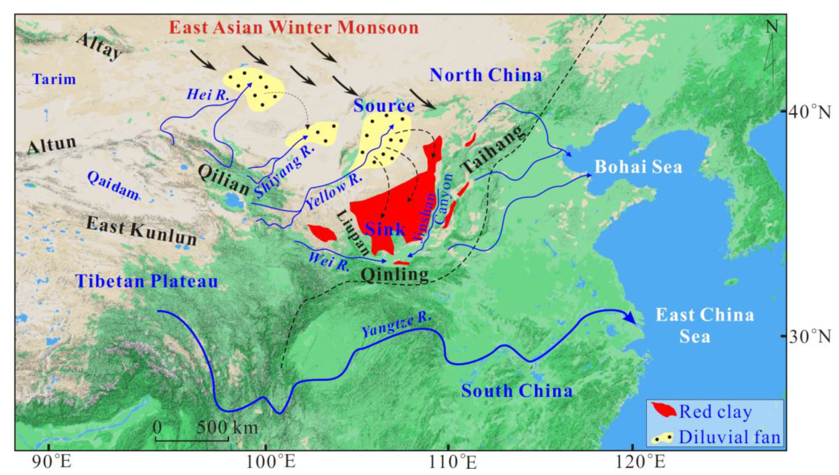
2. Research Background

2.1. Provenance of Detrital Zircon in Red Clay

The foothills of the orogenic belt feature diluvial fans formed by seasonal river transport, offering ample detrital material for the development of desert and red clay under the impact of surface airflow [2,13,38] (Figure 3). Rivers that originate in orogenic belts and flow into deserts typically transform into seasonal internal rivers [4,6]. The dried-out riverbeds play a crucial role as a substantial source for both red clay and desert formation [12,39]. Additionally, the eolian sediments can be transported over long distances in a suspended state in the upper atmosphere [66,67,68]. Hence, the eolian sediments can originate from near-surface diluvial fans, deserts, dry riverbeds, and the deposition of detrital material carried aloft over significant distances. As detrital material in red clay can originate from both local and/or distant sources, a common practice is to compare the U-Pb age spectra of detrital zircon with multiple potential red clay provenances [36].

2.2. Tectonic and Climatic Setting

The Qilian Shan is situated on the northeastern margin of the Tibetan Plateau (Figure 4). Evidence from sedimentology [69,70], palynology [71], and low-temperature thermochronology [72,73,74,75] indicates that rapid exhumation events occurred in the Qilian Shan during the periods of 20–14 and 11–7 Ma, leading to an elevation increase of 3685 ± 87 m [71]. The Qinling Shan, with an average altitude of 3000 m, is situated between the North China Craton and the South China Plate, acting as a climatic, geographical, and geological boundary separating North and South China (Figure 4). Neogene exhumation events in the Qinling Shan were observed at 22, 12, and 8 Ma [33,34,76]. The Taihang Shan, with an average altitude of 2000 m, is positioned within the North China Craton, stretching from the northeast to the southwest, and importantly serving as a climatic and geographical divide in North China (Figure 4). Rapid exhumation events in the Taihang Shan took place during the periods of 27–20 and 10 Ma [33,77,78,79]. During the early Neogene, the Tibetan Plateau had an average elevation exceeding 3500 m, greatly influencing the climatic evolution of East Asia [80,81]. The combined exhumation of the Qinling Shan and Taihang Shan places Northwest China in the rain shadow region of the East Asian summer monsoon, resulting in prevalent arid conditions [33,82].

2.3. Rivers and Deserts

The rivers originating from the northeastern parts of the Tibetan Plateau from west to east are primarily the Hei, Shiyang, Yellow, and Wei rivers (Figure 5a). The Hei River, with a total length of 948 km, begins in the western part of the Qilian Shan and flows downstream into the western side of the Badain Jaran Desert, where it forms a vast diluvial fan [84,85] (Figure 5a). The Shiyang River, with a total length of 250 km, originates in the eastern part of the Qilian Shan and flows downstream into the Tengger Desert [86]. The Yellow River spans a total length of 3472 km from its source to Hekou Town in its upper reaches [87] (Figure 5a). The upper course of the Yellow River passes through the Hedong Sandy Land and the Hobq Desert [53]. The middle reaches of the Yellow River extend from Hekou Town to Zhengzhou City, covering a total length of 1206 km [87] (Figure 5a). The Mu Us Desert is located on the west bank of the middle reaches of the Yellow River (Figure 5a). Lastly, the Wei River originates in the western region of the Qinling Shan, spanning a total length of 818 km and flowing from west to east into the Wei Basin, making it the largest tributary of the Yellow River [54] (Figure 5a). The lower Wei River originated in the late Paleogene [82], while the upper Wei River emerged in the Miocene [88,89].

2.4. Late Miocene–Pliocene Red Clay Profile

During the Late Miocene and Pliocene, the flat bedding of red clay in the Ordos Plateau does not exhibit clear distinctions, with the primary composition being fine silt and clay (63–2 μm), indicating the aeolian origin of the red clay [9,32,91]. However, thin fluvial deposits are visible in the lower segment of the Late Miocene–Pliocene red clay profile, indicating reworking by flowing water during the initial formation process [31,35,92]. The best outrops Late Miocene and Pliocene red clay profiles in the Ordos Plateau are primarily located in Dongwan (7.3–3.5 Ma; [25]), Chaona (8.1–2.5 Ma; [90]), Xifeng (8.1–2.5 Ma; [23]), Lingtai (7–2.5 Ma; [9]), Lantian (7.2–2.5 Ma; [35]), Jiaxian (7.6–2.5 Ma; [24]), Baode (7.2–2.7 Ma; [26]), Shilou (10.2–2.5 Ma; [27]), and Jingbian (3.6–2.6 Ma; [13]; Figure 4b–i). The age of these sections is mainly determined by paleomagnetic dating and Hipparion fossils [46,93], with thicknesses ranging from 20 to 120 m, exhibiting an unconformable contact with the underlying Mesozoic and Paleozoic strata [94].

3. Research Methods

3.1. Data Sources

A comprehensive compilation of previously published zircon U-Pb ages from Late Miocene to Pliocene red clay deposits in the Ordos Plateau was conducted [10,13,31,40,41,47,48,49], along with data on tectonics and climate [14,33,34], with the aim of investigating their potential sources (Figure 5a). Primary data were collected using Google Scholar’s search engine, with key search terms including red clay, Neogene, and detrital zircon. The red clay profile, which includes zircon U-Pb samples, stretches across the Ordos Plateau from east to west, encompassing Dongwan [10], Chaona [40], Xifeng [31], Lingtai [48], Jingbian [13], Jiaxian [41], Baode [10], Lantian [10,49], and Shilou [47] (Figure 5b–i). The sampled locations of potential sources span the Miocene to Pliocene strata within the Yumen Basin at the western end of the northern foothills of the Qilian Shan [69], as well as the Wuwei [95] and Yinchuan basins [52,55] in the eastern region. Additionally, we included data from Miocene strata in the Wushan [88], Tianshui [88], and Weihe basins [54,57] along the northern foothills of the Qinling Shan. Zircon U-Pb ages were also collected for the Miocene to Pliocene river terraces in the Hetao Basin [53] and Jinshan Canyon [56]. Furthermore, we obtained zircon U-Pb ages from modern river sediments sourced from the Hei [60], Shiyang [64,95], upper and middle Yellow [96], and Wei rivers [97]. In our analysis, we also incorporated zircon U-Pb age data from desert and sandy areas such as Badain Jaran [62,98], Tengger [39,62,64], Hedong [61,62,65], Mu Us [61,62,65], and Hobq [63], along with zircon U-Pb ages from the Gobi region in the southern Mongolia Plateau [59,60,62].

3.2. Data Processing
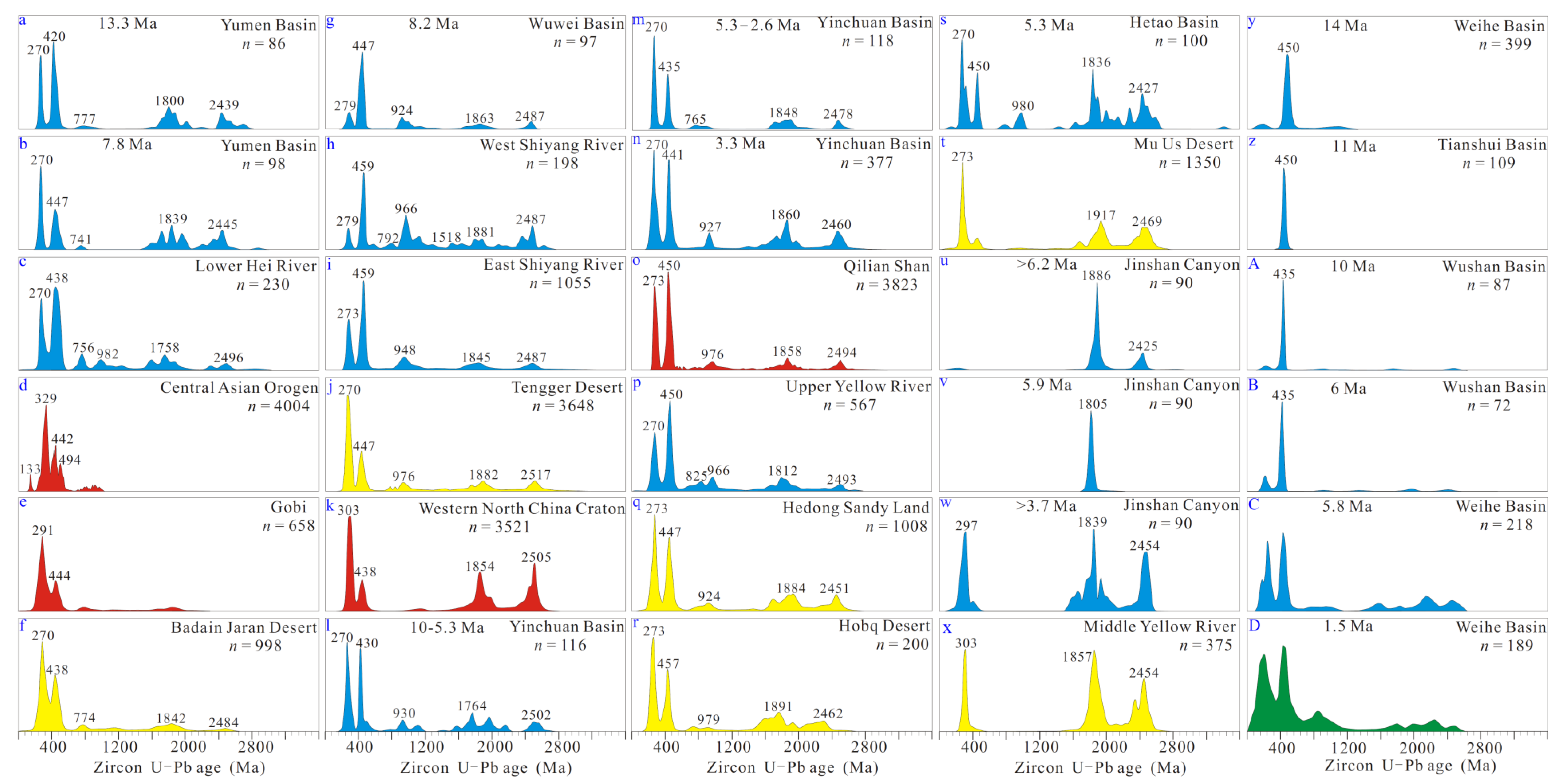
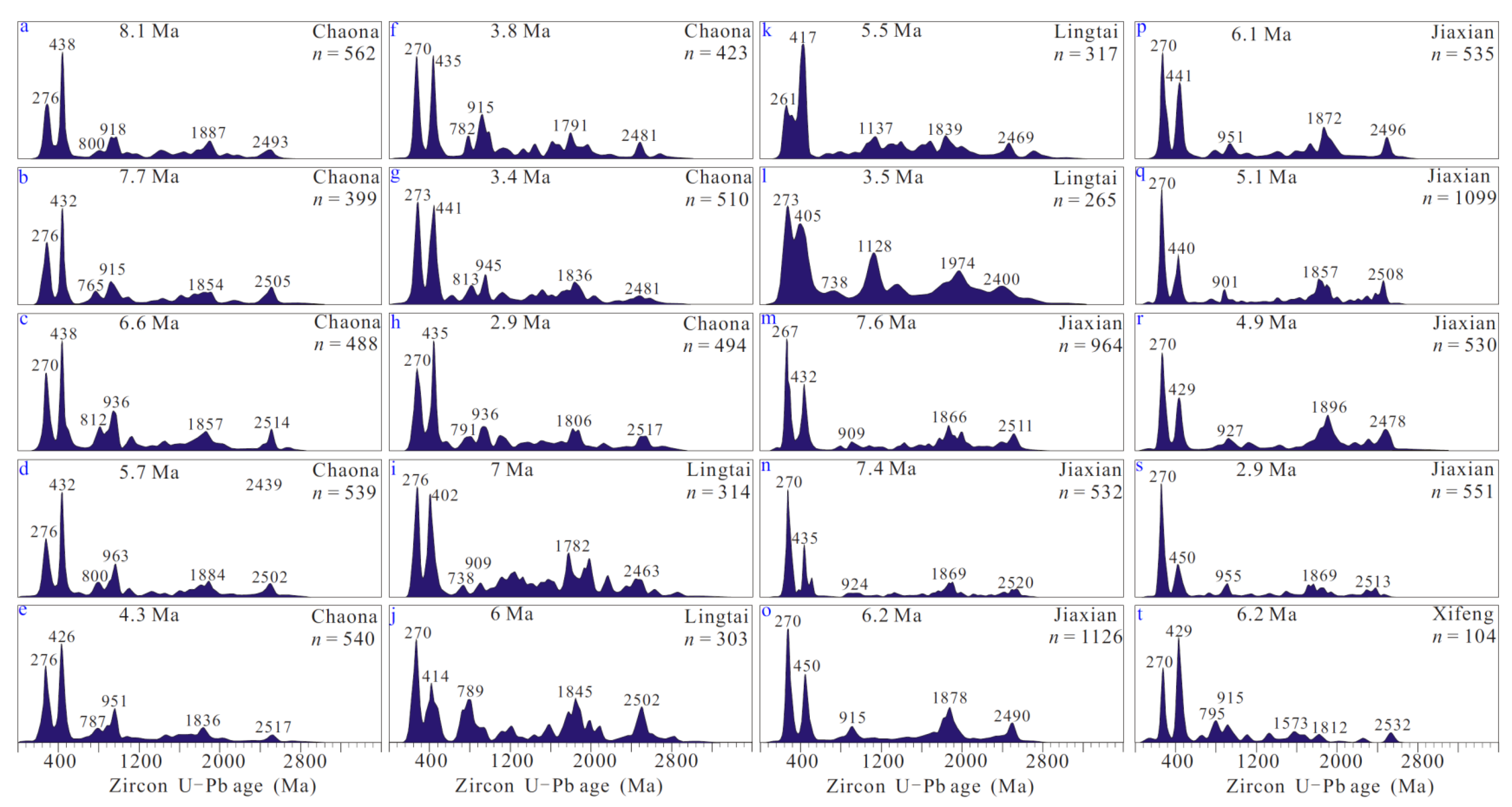
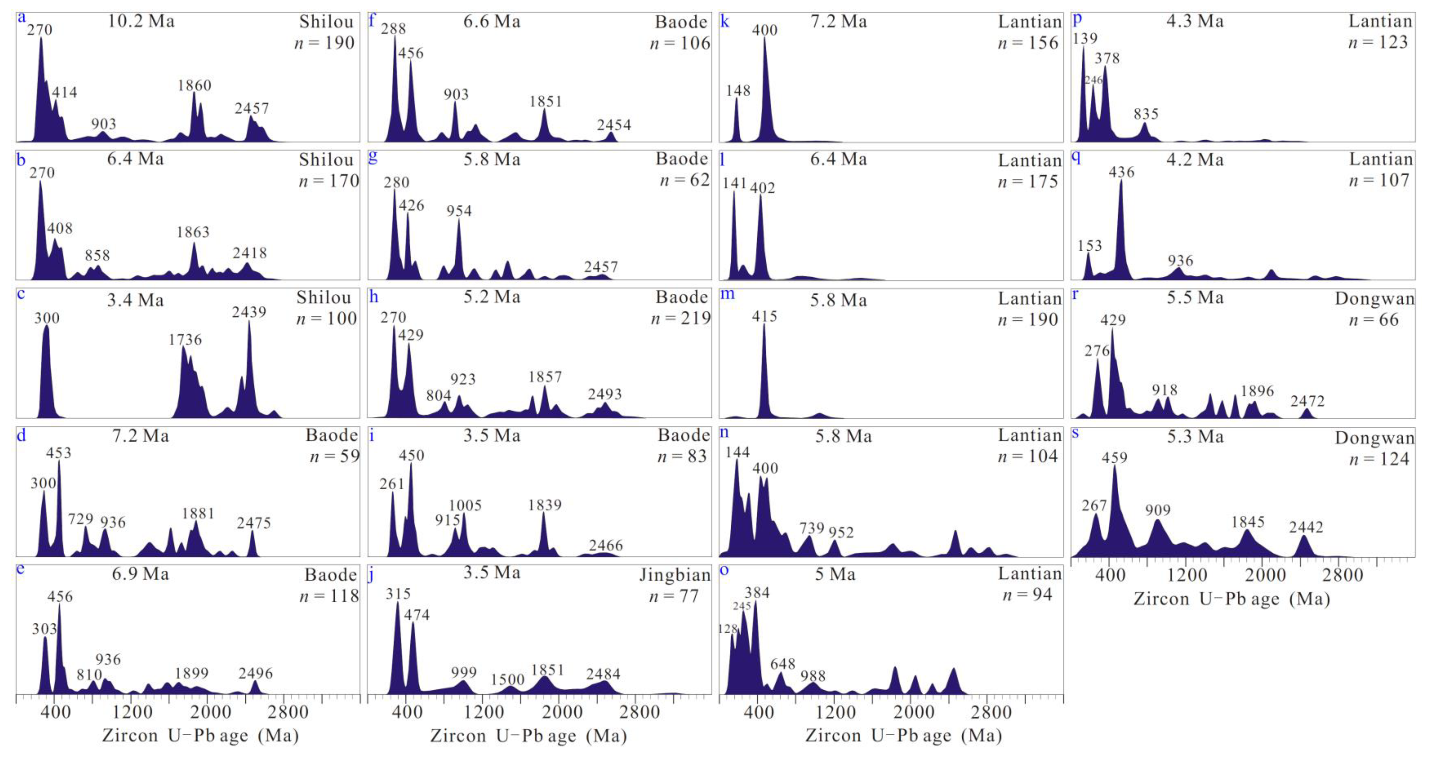
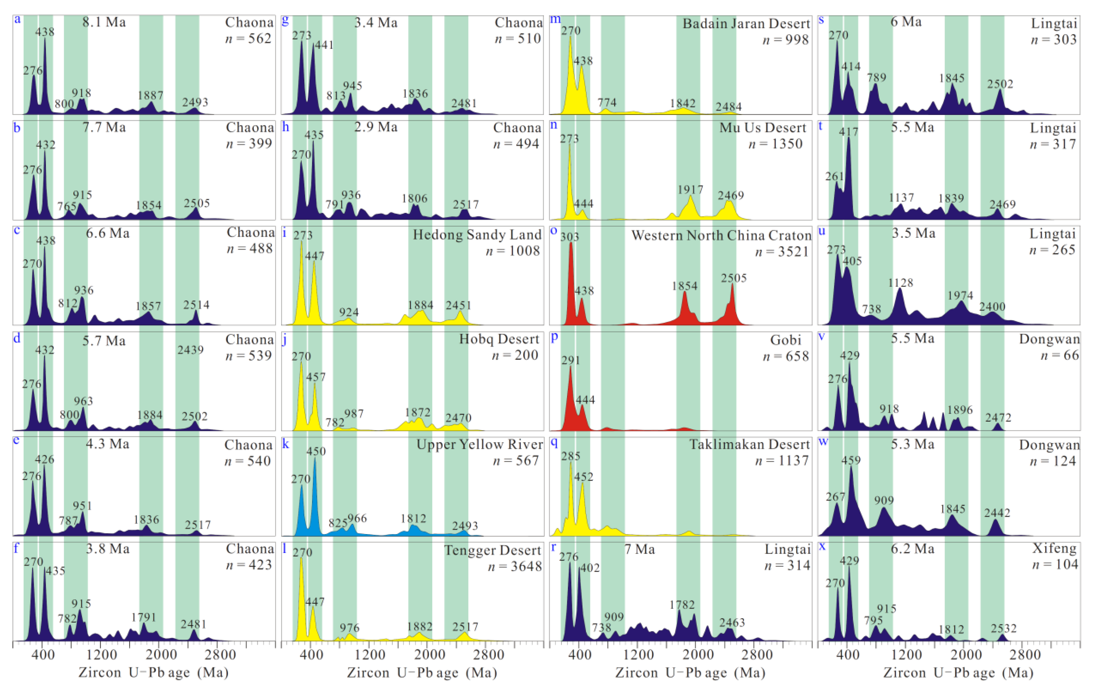
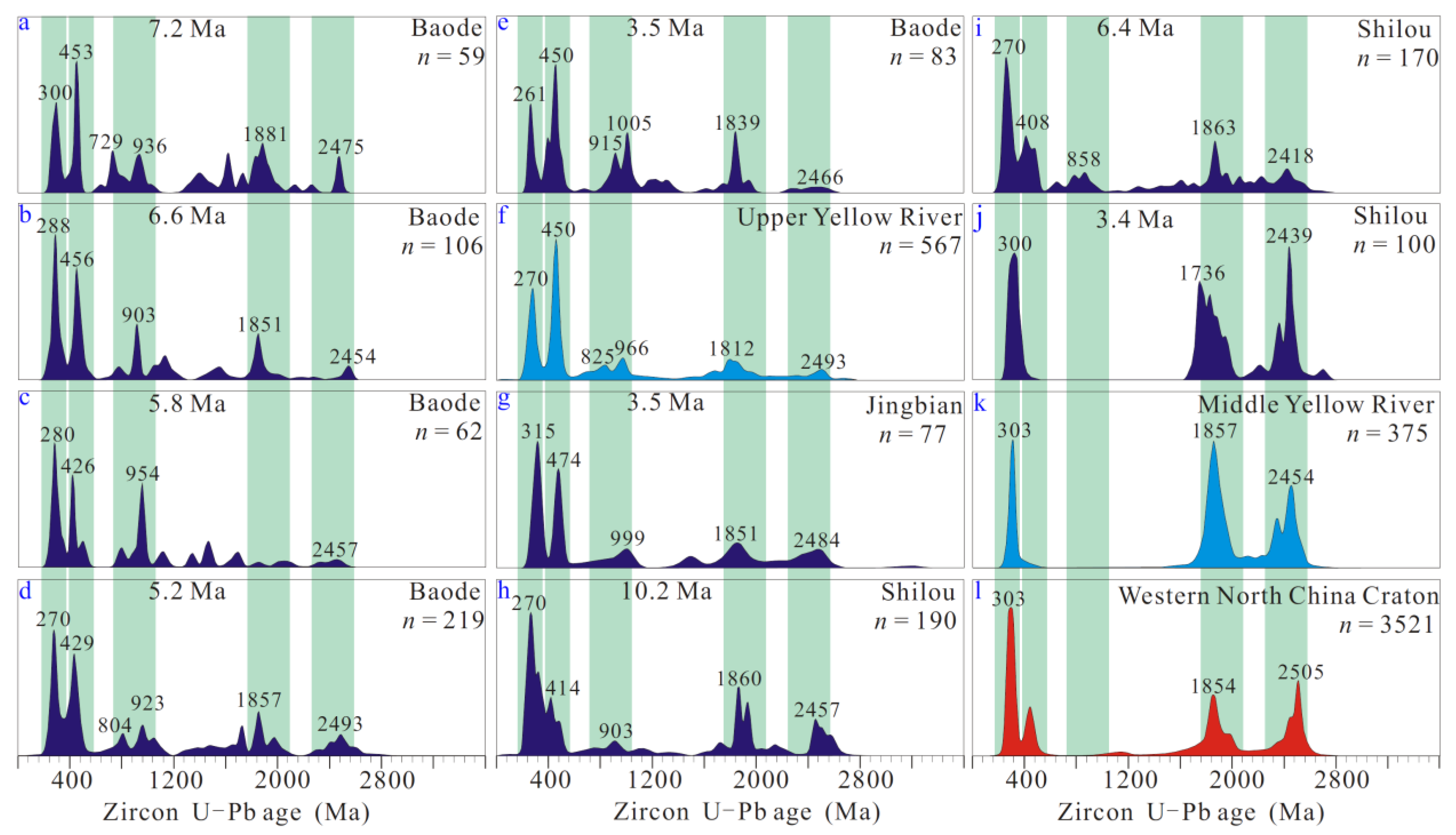
Specifically, in data analysis, 207Pb/206Pb data with ages exceeding 1000 Ma and 206Pb/238U data with ages under 1000 Ma are utilized. The 207Pb/206Pb and 206Pb/238U ages are used in geological and geochemical studies to determine the timing of the formation of a particular rock or mineral sample. When analyzing samples from different sources, the differences in these isotopic ages can be used to distinguish between local (autochthonous) and distant (allochthonous) sources [4,5,6]. Autochthonous sources refer to materials that have formed in place, while allochthonous sources refer to materials that have been transported from their original location. For example, on the one hand, if a rock sample has ages that are consistent with the local geological history of an area, it may suggest an autochthonous source, as the sample likely formed in place. On the other hand, if the ages indicate that the sample is significantly older or younger than the local geological history, it could indicate an allochthonous source, where the sample has been transported from a different location. The detrital zircon U-Pb ages were processed using ISOPLOT (version 3.0; [99]) and Density Plotter (version 6.4; [100]), which generated probability density maps. Multidimensional scaling (MDS) is a statistical technique used for data visualization to assess the similarity or dissimilarity of data points within a multi-dimensional space [101]. There are two primary types of MDS: metric MDS and non-metric MDS. Metric MDS aims to preserve the actual distances or similarities between data points, while non-metric MDS focuses on preserving the rank order of distances or similarities [102].

4. Results

The zircon U-Pb ages of Miocene strata (13.3 to 7.8 Ma) in the Yumen Basin show consistent results, with the identification of five age modes: 270, 447–420, 777–741, 1839–1800, and 2445–2439 Ma (Figure 6a,b). Similarly, zircon U-Pb ages from the lower reaches of the Hei River reveal six age modes: 270, 438, 756, 982, 1758, and 2496 Ma (Figure 6c). Zircon U-Pb age modes of the Central Asian orogenic belt encompass 133, 329, 442, and 494 Ma (Figure 6d). In the Gobi region of the southern Mongolia Plateau, two distinct zircon U-Pb age modes of 291 and 444 Ma are observed (Figure 6e). Furthermore, the Badain Jaran Desert exhibits five zircon U-Pb age modes: 270, 438, 774, 1842, and 2482 Ma (Figure 6f). The zircon U-Pb age distribution of Miocene strata at 8.2 Ma in the Wuwei Basin is similar to that of the West and East Shiyang River and Tenger Desert, with five age modes identified: 279–270, 459–447, 776–924, 1882–1845, and 2517–2487 Ma (Figure 6g–j). Furthermore, the zircon U-Pb age modes from the Neoproterozoic (792 Ma) and Mesoproterozoic (1518 Ma) periods can be observed in the West Shiyang River region. Zircon U-Pb age modes from the Western North China Craton are concentrated around 303, 438, 1854, and 2505 Ma (Figure 6k). In sediments deposited between 10 and 2.6 Ma, in Yinchuan Basin, the zircon U-Pb age modes are primarily 270, 441–430, 930–747, 1860–1842, and 2547–2478 Ma (Figure 6l–n). Additionally, zircon U-Pb ages from the Qilian Shan, upper Yellow River, Hedong Sandy Land, Hobq Desert, and Hetao Basin exhibit five age modes: 273–270, 457–447, 980–825, 1891–1812, and 2494–2427 Ma (Figure 6o–s). The Mu Us Desert shows three age modes: 273, 1917, and 2469 Ma (Figure 6t). The zircon U-Pb age distribution of river terraces, formed at >6.2 and 5.9 Ma in the Jinshan Canyon, reveals a prevalence of Neoproterozoic age modes (1886 and 1805 Ma; Figure 6u,v). Three age modes are identified in the river terrace of Jinshan Canyon and the Yellow River at >3.7 Ma: 303–297, 1857–1839, and 2454 Ma (Figure 6w,x). In the Weihe, Tianshui, and Wushan basins during the 14–6 Ma, a single early Paleozoic zircon U-Pb age mode (450–235 Ma) is present (Figure 6y–B). The zircon U-Pb ages of Upper Miocene and Lower Pleistocene (5.8–1.5 Ma) strata in the Weihe Basin show similarities in their age modes, mainly comprising late and early Paleozoic ages (Figure 6C,D).
The Chaona section exhibits a stratigraphic depositional age ranging from 8.1 to 2.9 Ma, with zircon U-Pb age modes of 276–270, 441–426, 813–765, 963–915, 1887–1791, and 2517–2481 Ma (Figure 7a–h). In the Lingtai section (7–3.5 Ma), the zircon U-Pb age modes are concentrated around 276–261, 417–402, 1137–736, and 2502–2400 Ma (Figure 7i–l). The Jiaxian section (7.4–2.9 Ma) mainly consists of zircon U-Pb age modes in the following ranges: 270–267, 450–329, 955–901, 1896–1857, and 2520–2478 Ma (Figure 7m–s). Finally, the Xifeng section at 6.2 Ma is characterized by zircon U-Pb age modes of 270, 429, 795, 915, 1573, 1812, and 2532 Ma (Figure 7t).
The Shilou profile exhibits five zircon U-Pb age modes at 10.2 and 6.4 Ma: 270, 414–408, 903–858, 1863–1860, and 2547–2418 Ma (Figure 8a,b). On the contrary, the Shilou profile presents three zircon U-Pb age modes at 3.4 Ma: 300, 1736, and 2439 Ma (Figure 8c). The Baode section, dated between 7.2 and 3.5 Ma, is characterized by a wide dispersion of ages, but they can be grouped in those of 303–261, 456–426, 1005–729, 1899–1839, and 2496–2454 Ma (Figure 8d–i). Furthermore, the Jingbian profile at 3.5 Ma includes zircon U-Pb age modes of 315, 474, 999, 1500, 1851, and 2484 Ma (Figure 8j). The Lantian profile displays two significant zircon U-Pb age modes at 7.2–6.4 Ma: 148–141 Ma and 402–400 Ma (Figure 8k,l). At 5.8 Ma, the Lantian section shows zircon U-Pb age modes of 144, 400, 415, 739, and 952 Ma (Figure 8m,n). Additionally, the zircon U-Pb age modes in the Lantian section from 5.0–4.2 Ma are concentrated in 139–128, 246–245, 383–378, and 988–648 Ma (Figure 8o–q). The Dongwan section exhibits five main zircon U-Pb age modes: 276–267, 459–429, 918–909, 1896–1845, and 2472–2442 Ma (Figure 8r,s).
In the MDS diagram, samples from the Chaona, Lingtai, Dongwan, Xifeng, Jiaxian, Baode, and Jingbian sections are closest to the Hobq Desert, the Hedong Sandy Land, or the upper Yellow River (Figure 9a–g). The samples from the 10.3 and 6.4 Ma in the Shiliou section are closest to the Hobq Desert and the Hedong Sandy Land, while the 3.4 Ma samples are closest to the middle Yellow River (Figure 9h). The Lantian section sample at 7.2–4.3 Ma is closest to the Wushan Basin sample at 10–6 Ma, and the 4.2 Ma sample is closest to the Qinling Shan (Figure 9i).

5. Discussion

5.1. Provenance of Potential Source Area of Red Clay

Compared to sediments from rivers or glaciers, which mainly come from their respective river basins, aeolian sediments have source areas that are more widely dispersed [11,106,107]. Therefore, before investigating the origin of the Late Miocene to Pliocene red clay in the Ordos Plateau, it is crucial to establish the provenance of its potential source regions. This assessment will help clarify the formation mechanism of these red clays.
The zircon U-Pb ages of the Late Miocene (13.3–7.8 Ma) strata in the Yumen Basin exhibit a similar composition to those of the Qilian Shan [64,69,98] (Figure 6a,b,o). Examination of heavy minerals obtained from sedimentary boreholes in the upper reaches of the Hei River indicates that the river originated at least 7 Ma [108,109,110]. The U-Pb age composition of detrital zircons in the lower reaches of the Hei River resembles that of the Qilian Shan [60,64,98] (Figure 6c,o) but differs from those of the Central Asian orogenic belt and the Gobi region [59,60,62] (Figure 6c–e). The U-Pb age composition of zircons in the Badain Jaran Desert is comparable to that of the lower reaches of the Hei River and the Qilian Shan [60,62,64,98] (Figure 6c,f,o). Similarly, the U-Pb age composition of the Wuwei Basin at 8.2 Ma corresponds to that of the Shiyang River in the eastern Qilian Shan, implying the presence of the Shiyang River during the Late Miocene [95] (Figure 6g–i). Notably, the detrital zircon U-Pb age composition of the Tengger Desert displays a significant Neoproterozoic age mode of 976 Ma, which is also observed in both the Wuwei Basin and the Shiyang River [62,64,65,95] (Figure 6h–j). This suggests a substantial sedimentary contribution from the Shiyang River to the Tengger Desert.
The zircon U-Pb age composition of the Late Miocene–Pliocene (10–2.6 Ma) strata in the Yinchuan Basin exhibits similarities with those of the Qilian Shan and the upper reaches of the Yellow River [52,55,64,96,98] (Figure 6l–p). This implies that the northeastern margin of the Tibetan Plateau served as a source for the upper reaches of the Yellow River, which subsequently flowed into the Yinchuan Basin during this period [62,109]. The zircon U-Pb age composition found in the Hedong Sandy Land and the Hobq Desert corresponds to that of the upper reaches of the Yellow River [61,62,63,65] (Figure 6p–r), indicating that detrital material from the upper Yellow River played a significant role in shaping the development of the Hedong Sandy Land and the Hobq Desert [96]. In the Hetao Basin, evidence of material from the upper reaches of the Yellow River can be traced back to at least 5.3 Ma ([53]; Figure 6p,s). However, during the Miocene and Pliocene (>6.2–3.7 Ma), rivers flowed into the northern part of the Jinshan Canyon in the Hetao Basin and into the southern part of the Jinshan Canyon in the Weihe Basin ([56,58,111]; Figure 6u–w). Thus, during the Late Miocene and Pliocene, the Hei, Shiyang, and Yellow rivers, originating in the Qilian Shan, were all internal rivers [112]. The zircon U-Pb age composition in the Mu Us Desert, near the middle reaches of the Yellow River, resembles that of the Western North China Craton [61,62,65,103,104,105], with no clear Neoproterozoic age mode evident (Figure 6k,t).
Bulk geochemistry and heavy mineral assemblage results indicate that the materials in the Mu Us Desert primarily stem from the weathering of bedrock in the Western North China Craton [113,114]. The Weihe, Tianshui, and Wushan basins show a shared Paleozoic zircon U-Pb age mode during the Middle–Late Miocene (14–6 Ma; [57,88]; Figure 6y–B). Paleo-flow and sedimentological evidence suggest that the Wei River has been linking the Tianshui, Wushan, and Weihe basins since the Middle–Late Miocene [88,89], likely in response to the activity of the strike-slip fault zone at the north piedmont of the Qinling Shan [89,109,115]. Nonetheless, provenance tracing results from the Bohai Bay and the South Yellow Sea basins do not suggest the presence of the Wei River during this period [116,117,118,119,120]. Moreover, the fault depression depth of the Weihe Basin in the Neogene exceeded 4000 m [121]. During this period, both the Wei and the middle Yellow rivers exhibited signs of internal flow as they entered the Weihe Basin [112]. The U-Pb age composition of detrital zircons from the Weihe Basin at 5.8 Ma and 1.5 Ma are similar [54,57], although the age mode becomes complex in comparison to that from 14 Ma (Figure 6C,D), indicating provenance changes in the Wei River since 5.8 Ma.

5.2. Provenance of Red Clay

The composition of zircon U-Pb ages in the Chaona section (8.1–2.9 Ma) demonstrates consistent relative patterns from bottom to top ([40]; Figure 10a–h). In the multidimensional scaling (MDS) diagram (Figure 9a), these samples cluster closely, indicating no significant changes in provenance from the Late Miocene to Pliocene. The U-Pb age spectrum of the red clay in the Chaona section closely resembles that of the Hedong Sandy Land [61,62,65], the Hobq Desert [63], and the upper Yellow River ([96]; Figure 10i–k). Although the composition of zircon U-Pb ages in the Badain Jaran [62,98] and Tengger deserts ([62,64,65]; Figure 10l,m) shows similarities to the Chaona section ([40]; Figure 10a–h), the proximity of the upper Yellow River to the Ordos Plateau suggests that detritus from the upper Yellow River is preferentially transported and deposited in the Ordos Plateau. The Mu Us Desert shows signs of bedrock weathering in the Western North China Craton [9,62,64,65,87], displaying a less prominent Neoproterozoic age mode compared to the red clay in the Chaona section (Figure 10n,o). While evidence suggests the presence of the Taklimakan Desert and Gobi region during the Late Miocene to Pliocene [122,123,124], the detrital zircon U-Pb ages from these regions do not exhibit significant Paleoproterozoic and Neoarchean ages ([5,59,60,62]; Figure 10p,q). Therefore, it is unlikely that the detrital material from the Western North China Craton, Gobi, and the Taklimakan Desert was the primary source for the red clay in the Chaona section. Furthermore, boreholes from the Badain Jaran [125], Tengger [86], and Hobq [126] deserts indicate that these deserts mainly formed in the Quaternary, with the earliest formation age not exceeding 2.5 Ma. Hence, the primary origin of Neogene red clay in the Chaona section can be directly linked to clastic material from the Yellow River in the Yinchuan and Hetao basins.
The U-Pb age composition of detrital zircons from the Lingtai [98], Dongwan [10], and Xifeng [31] sections during the Late Miocene to Pliocene (7–3.5 Ma) is similar to that of the upper reaches of the Yellow River ([96]; Figure 10k,r–x). Certain samples in the Lingtai section exhibit a prominent age mode around ~1150 (Figure 10t,u), which likely originates from the clastic material produced by the weathering of the bedrock in the Western North China Craton. This finding is in line with previous U-Pb age source tracing results of detrital rutile from the Lingtai red clay [127]. According to the MDS diagram (Figure 9b–d), the Lingtai, Dongwan, and Xifeng profiles are closely associated with the Hedong Sandy Land, the Hobq Desert, and the upper Yellow River. This suggests that the main source of red clay in the Lingtai, Dongwan, and Xifeng sections during the Late Miocene and Pliocene was the upper reaches of the Yellow River. The zircon U-Pb age composition of the Jiaxian section between 7.6 and 3 Ma consistently aligns with the characteristics of the upper Yellow River ([41,96]; Figure 11). However, some samples from the Jiaxian section in the MDS plot show proximity to the Mu Us Desert (Figure 9e). This indicates that the red clay in the Jiaxian section likely originated from both the upper Yellow River and the clastic material from the Western North China Craton between 7.6 and 3 Ma. Similarly, the zircon U-Pb age mode composition of red clay in the Baode section at 7.2–3.5 Ma corresponds to that of the upper Yellow River ([10,96]; Figure 12a–f). The MDS plot (Figure 9f) also demonstrates a close alignment between the red clay in the Baode section and the upper Yellow River. These findings highlight the upper reaches of the Yellow River as the primary provenance area of red clay in the Late Miocene and Pliocene of the Baode section. In the Jingbian section at 3.5 Ma, the zircon U-Pb age mode composition and pattern of red clay more consistently resemble those of the upper reaches of the Yellow River ([13,96]; Figure 12f,g). However, the presence of a 315 Ma age mode does not completely negate the influence of weathering materials from the bedrock in the Western North China Craton. Lastly, the provenance of red clay in the Shiliou section underwent changes during the Late Miocene and Pliocene. The zircon U-Pb age composition of the red clay in the Shiliou section between 10.2 and 6.4 Ma shows similarities to that of the upper Yellow River ([47,96]; Figure 12f,h,i). However, the red clay in the Shilou section aligns with the middle Yellow River at 3.4 Ma [56], suggesting the influence of clastic material from the western part of the North China Craton ([103,104,105]; Figure 12j–l).
The zircon U-Pb age composition of the red clay (7.2–4.3 Ma) from the Lantian section shows clear distinctions in Mesozoic (148–139 Ma) and Paleozoic age modes (402–378 Ma; [10,49]; Figure 13a–c). However, the presence of Paleoproterozoic and Neoarchean age modes is less evident. This finding contrasts with the U-Pb age composition of zircon from the upper Yellow River ([96]; Figure 13d), suggesting that the detrital material in the upper Yellow River is not the primary source area for the Lantian section during this period. At 7.2–4.3 Ma, the early Paleozoic zircon U-Pb age mode (450–435 Ma) in the Lantian section correlates with the strata aged 14–6 Ma in the Weihe, Tianshui, and Wushan basins ([10,49,57,88]; Figure 13e–h). Conversely, the early Mesozoic age mode primarily originates from the Qinling Shan (142 Ma; [128] Figure 13n). The spatial distribution of the red clay composition in the Lantian section varies during 5.8–4.2 Ma. Some samples (5.8 Ma) exhibit zircon U-Pb age compositions that align with the 14–6 Ma strata in the Weihe, Tianshui, and Wushan basins ([10,57,88]; Figure 13e–i). However, other samples (5.8 and 5 Ma) display a complex zircon U-Pb age composition, including early Mesozoic (144, 128 Ma), early Paleozoic (436–384 Ma), and Neoproterozoic age modes ([49,57,88]; Figure 13k–m). This complexity reflects the distinctive characteristics of the Qinling orogenic belt. The less distinct Paleoproterozoic and Neoarchean age modes may be attributed to the influence of the Wei River ([97]; Figure 13k,l,o).

5.3. Formation Mechanism of Red Clay

The main factors of red clay formation include the availability of abundant and fine-grained sediment, strong winds for transportation, and suitable terrain for deposition ([2,11,12,129,130,131]). These factors contribute to the accumulation of eolian sediments, leading to the formation of red clay deposits over time. Firstly, the development of investigated red clay was significantly influenced by the presence of river sediments during the Late Miocene–Pliocene in the Ordos Plateau. The red clays found in the Dongwan, Chaona, Xifeng, Jingbian, Jiaxian, Baode, and Shilou sections can be traced back to their origins in the upper Yellow River during the Late Miocene (Figure 14). The exposure of detrital material in the expansive canyon of the middle reaches of the Yellow River during the dry season played a crucial role in the formation of red clay in the Shilou section, approximately 3.4 Ma. Furthermore, the evolution of the Wei River in the Miocene and Pliocene provided ample clastic materials for the deposition of red clay in the Lantian section. Throughout the Miocene and Pliocene, the Wei and Yellow rivers accumulated a substantial amount of detrital material [52,53,55], which did not reach the sea but rather served as the foundational material for the development of red clay in the Ordos Plateau. This pattern of aeolian sediment development is also observed in various regions, including the northern foothills of the Altun Shan in the northern Tibetan Plateau ([47]; Figure 1), the Tajik Basin in the western Pamir Plateau (Wang et al., 2016b; Figure 1), the Pannonian Basin in the Carpathian Mountains [132], and the Pampas Plain east of the Andes [133]. Hence, the significant amount of detrital material delivered by the consistent seasonal rivers ensured the effective deposition of Late Miocene and Pliocene red clay in the Ordos Plateau.
Secondly, an escalation occurred in the East Asian winter monsoon during the Late Miocene and Pliocene, possibly triggered by global cooling, the rise of the Tibetan Plateau, and the southward expansion of the Arctic polar cold high ([12,24,134,135,136,137]). Throughout this period, the East Asian winter monsoon consistently influenced Northwest China, playing a significant role in the development of red clay in the Ordos Plateau [9,10,13,40,41,47,48,138]. The development of thick salt lake sediments in the Yinchuan and Hetao basins suggests the prevailing arid climate to the west of the Ordos Plateau during the Miocene and Pliocene [139,140,141]. This aridity facilitated the formation of loose detrital deposits that were easily transported by the East Asian winter monsoon.
Thirdly, the Ordos Plateau, situated in the western part of the North China Craton, has an average elevation of 1000 m (Figure 1b,c). Detrital materials eroded from the Taihang, Qinling, and Qilian Shan were transported into the Ordos Basin during the Mesozoic and early Cenozoic periods [34,94,104]. The Ordos Basin amassed extensive fluvial and lacustrine deposits over time and was subsequently uplifted into a plateau during the late Cenozoic period due to the expansion of the northeastern margin of the Tibetan Plateau [94,121]. The flat geomorphic feature of the plateau facilitated the significant accumulation of aeolian sediments on its surface [2,94]. The absence of high mountains in the northern terrain of the Ordos Plateau allowed the unimpeded influence of the East Asian winter wind [13]. Conversely, the southern and eastern regions of the Ordos Plateau, encompassing the Qinling and Taihang Shan, each with an average height exceeding 3000–2000 m, effectively intercept near-surface aeolian deposits [33,34,78]. Additionally, the Ordos Plateau is located in the rain shadow region of the East Asian summer monsoon [82]. The arid climate supports the preservation of red clay, despite some modification from surface water flow [11,30,31].
Lastly, the Tarim Basin underwent a transformation into a semi-enclosed geomorphic region, bounded by the Tian Shan in the north, the Pamir Plateau in the west, and the West Kunlun Shan in the south during the Late Miocene ([142,143,144,145,146]; Figure 1). Despite the emergence of the Taklimakan Desert during this period [122,123], extensive red clay deposits did not accumulate in the Tarim Basin [11]. The presence of the Tian Shan, with peaks exceeding 3000 m, hindered the transport of detrital materials by the East Asian winter monsoon and westerly winds into the Tarim Basin [147,148,149]. Additionally, the arid climate in the region suppressed the development of large seasonal rivers [150,151,152], leading to an inadequate supply of detrital materials crucial for red clay formation [153,154]. While there is some evidence suggesting that detrital material from the Tarim Basin could have traveled as far as the Pacific Ocean [155,156], it is probable that a substantial portion was carried into the stratosphere, which could have hindered its settling over shorter distances on the Ordos Plateau [157]. During the Late Miocene, the Mongolian Gobi was situated in a rain shadow area resulting from the uplift of the Mongolian Plateau [158,159]. This uplift acted as a barrier, obstructing moisture from the Arctic and Atlantic Oceans [160]. Consequently, the arid climate in this region restricted the formation of large rivers in the southern slopes of the Altay and the Khangay Shan [161,162]. This condition ultimately led to lower production efficiency (28–7.5 m/Ma) of detrital materials within the Mongolian Gobi [161]. Significantly, the extensive development of the Mongolian Gobi took place around 2.6 Ma [124], clearly occurring later than the formation of red clay in the Late Miocene and Pliocene from the Ordos Plateau. By the Late Miocene, the Qaidam Basin had evolved into a closed basin, encircled by the Altun Shan to the west, Qilian Shan to the north, and East Kunlun Shan to the south and east ([72,163,164]; Figure 1), hindering the development of large internal rivers due to the arid environment [165,166]. During this period, arid conditions led to extensive salt lake formations in the Qaidam Basin, impeding the formation and development of red clay deposits in the region [166]. The arid climate of the basin, combined with a shortage of detrital material supply and geographical barriers like the Qilian and East Kunlun Shan, impeded significant exports of detrital materials from the Qaidam Basin [167]. The research findings suggest that during the Late Miocene and Pliocene, the deserts of the Tarim and Qaidam basins, as well as the Mongolia Gobi, contributed detrital materials to the Ordos Plateau, resulting in periodic shifts in the provenance of the red clay [168]. However, this phenomenon is not crucial for the overall development of these red clays [12]. In summary, the significant influx of clastic materials from the upper and middle Yellow River and Wei River during the Late Miocene and Pliocene, coupled with the persistent East Asian winter monsoon, the flat topography of the Ordos Plateau, and the barrier effect of the Qinling and Taihang Shan, collectively contribute to the extensive development of red clay in the Ordos Plateau.
However, the red clay predominantly formed in the western Ordos Plateau during the Late Oligocene and Early Miocene [14,15,16,17,18,19,20,21,22], while its development in the eastern part was hindered by the absence of the Yellow River flow from the Tibetan Plateau during that period. In the Longzhong Basin, the uplift of the Qilian Shan and Qinling Shan influenced the formation of the piedmont diluvial fan [50,88,89,169], creating conducive conditions for red clay development in the Late Oligocene and Early Miocene [14,170,171].
However, these conditions were inadequate to support extensive red clay deposits, leading to its predominant deposition in the western part of the Ordos Plateau. This observation further highlights the nearby accumulation development pattern of red clay in the Ordos Plateau.

6. Conclusions

The U-Pb ages of detrital zircons found in the Late Miocene and Pliocene red clays of the Ordos Plateau were compared with those from the potential source regions, taking into account the tectonic and climatic backgrounds. We have identified the provenance regions of these red clays, discussed their formation mechanism, and drawn the following conclusions:
(1)
The Late Miocene and Pliocene red clay in the Ordos Plateau primarily originates from the upper and middle Yellow River and the Wei River. The weathering of bedrock in the western part of the North China Craton plays a secondary role in the development of the red clay. The deposition of red clay in the late Miocene and Pliocene of the Ordos Plateau follows a proximal accumulation pattern.
(2)
The extensive deposition of Late Miocene and Pliocene red clay in the Ordos Plateau is attributed to the abundant fluvial clastic material, intensified East Asian winter monsoon, flat topography of the Ordos Plateau, and the presence of the Qinling and Taihang Shan as geomorphic barriers. The Tarim Basin, Mongolian Gobi, and Qaidam Basin were not the primary sources of red clay deposits in the Ordos Plateau.
The mechanism proposed in this study for the Late Miocene and Pliocene red clay development on the Ordos Plateau in Northwest China differs from previous theories focusing on hydrogenic or aeolian processes. Instead, the new mechanism proposed emphasizes the combined role of both hydraulic and wind power. This implies that not only water but also wind activity are significant factors in the accumulation and deposition of red clay in the region.

Author Contributions

Conceptualization, X.L. and C.H.; methodology, R.W.; software, L.Q.; validation, R.X., Z.A. and H.L.; formal analysis, X.L.; investigation, C.H.; resources, R.W.; data curation, X.L.; writing—original draft preparation, X.L.; writing—review and editing, X.L.; visualization, C.H.; supervision, R.W.; project administration, X.L.; funding acquisition, X.L. All authors have read and agreed to the published version of the manuscript.

Funding

The authors express their gratitude for the financial support provided by the National Natural Science Foundation of China (Grant No. 41972212) and the Hubei Chutian Scholars Talent Program (Grant No. 8210403).

Acknowledgments

We are deeply grateful to the three anonymous reviewers for their revision suggestions and changes to the manuscript.

Conflicts of Interest

The authors declare no conflict of interest.

References

  1. Tang, Z.H.; Ding, Z.L. A palynological insight into the Miocene aridification in the Eurasian interior. Palaeoworld 2013, 22, 77–85. [Google Scholar] [CrossRef]
  2. Rodríguez-López, J.P.; Clemmensen, L.B.; Lancaster, N.; Mountney, N.P.; Veiga, G.D. Archean to Recent aeolian sand systems and their sedimentary record: Current understanding and future prospects. Sedimentology 2014, 61, 1487–1534. [Google Scholar] [CrossRef]
  3. Rea, D.K. The paleoclimatic record provided by eolian deposition in the deep sea: The geologic history of wind. Rev. Geophys. 1994, 32, 159–195. [Google Scholar] [CrossRef]
  4. Garzanti, E.; Vermeesch, P.; Andò, S.; Vezzoli, G.; Valagussa, M.; Allen, K.; Kadi, K.A.; Al-Juboury, A.I. Provenance and recycling of Arabian desert sand. Earth-Sci. Rev. 2013, 120, 1–19. [Google Scholar] [CrossRef]
  5. Rittner, M.; Vermeesch, P.; Carter, A.; Bird, A.; Stevens, T.; Garzanti, E.; Andò, S.; Vezzoli, G.; Dutt, R.; Xu, Z.; et al. The provenance of Taklamakan desert sand. Earth Planet. Sci. Lett. 2016, 437, 127–137. [Google Scholar] [CrossRef]
  6. Licht, A.; Folch, A.; Sylvestre, F.; Yacoub, A.N.; Cogné, N.; Abderamane, M.; Deschamps, P. Provenance of aeolian sands from the southeastern Sahara from a detrital zircon perspective. Quat. Sci. Rev. 2024, 328, 108539. [Google Scholar] [CrossRef]
  7. von Eynatten, H.; Dunkl, I. Assessing the sediment factory: The role of single grain analysis. Earth-Sci. Rev. 2012, 115, 97–120. [Google Scholar] [CrossRef]
  8. Bird, A.; Stevens, T.; Rittner, M.; Vermeesch, P.; Carter, A.; Andò, S.; Garzanti, E.; Lu, H.; Nie, J.; Zeng, L.; et al. Quaternary dust source variation across the Chinese Loess Plateau. Palaeogeogr. Palaeoclimatol. Palaeoecol. 2015, 435, 254–264. [Google Scholar] [CrossRef]
  9. Ding, Z.L.; Xiong, S.F.; Sun, J.M.; Yang, S.L.; Gu, Z.Y.; Liu, T.S. Pedostratigraphy and paleomagnetism of a ~7.0 Ma eolian loess–red clay sequence at Lingtai, Loess Plateau, north-central China and the implications for paleomonsoon evolution. Palaeogeogr. Palaeoclimatol. Palaeoecol. 1999, 152, 49–66. [Google Scholar] [CrossRef]
  10. Shang, Y.; Beets, C.J.; Tang, H.; Prins, M.A.; Lahaye, Y.; van Elsas, R.; Kaakinen, A. Variations in the provenance of the late Neogene Red Clay deposits in northern China. Earth Planet. Sci. Lett. 2016, 439, 88–100. [Google Scholar] [CrossRef]
  11. Sun, Y.; Yan, Y.; Nie, J.; Li, G.; Shi, Z.; Qiang, X.; An, Z. Source-to-sink fluctuations of Asian aeolian deposits since the late Oligocene. Earth-Sci. Rev. 2020, 200, 102963. [Google Scholar] [CrossRef]
  12. Bohm, K.; Stevens, T.; Kaakinen, A.; Lahaye, Y.; O‘Brien, H.; Zhang, Z. The provenance of late Cenozoic East Asian Red Clay: Tectonic-metamorphic history of potential source regions and a novel combined zircon-rutile approach. Earth-Sci. Rev. 2022, 225, 103909. [Google Scholar] [CrossRef]
  13. Sun, J.; Ding, Z.; Xiao, W.; Windley, B.F. Coupling between uplift of the Central Asian Orogenic Belt-NE Tibetan Plateau and accumulation of aeolian Red Clay in the inner Asia began at ~7 Ma. Earth-Sci. Rev. 2022, 226, 103919. [Google Scholar] [CrossRef]
  14. Guo, Z.T.; Ruddiman, W.F.; Hao, Q.Z.; Wu, H.B.; Qiao, Y.S.; Zhu, R.X.; Liu, T.S. Onset of Asian desertification by 22 Myr ago inferred from loess deposits in China. Nature 2002, 416, 159–163. [Google Scholar] [CrossRef] [PubMed]
  15. Fang, X.; Garzione, C.; Van der Voo, R.; Li, J.; Fan, M. Flexural subsidence by 29 Ma on the NE edge of Tibet from the magnetostratigraphy of Linxia Basin, China. Earth Planet. Sci. Lett. 2003, 210, 545–560. [Google Scholar] [CrossRef]
  16. Lu, H.; Wang, X.; An, Z.; Miao, X.; Zhu, R.; Ma, H.; Li, Z.; Tan, H.; Wang, X. Geomorphologic evidence of phased uplift of the northeastern Qinghai-Tibet Plateau since 14 million years ago. Sci. China Earth Sci. 2004, 47, 822–833. [Google Scholar] [CrossRef]
  17. Qiang, X.; An, Z.; Song, Y.; Chang, H.; Sun, Y.; Liu, W.; Ai, L. New eolian red clay sequence on the western Chinese Loess Plateau linked to onset of Asian desertification about 25 Ma ago. Sci. China Earth Sci. 2011, 54, 136–144. [Google Scholar] [CrossRef]
  18. Zhang, Y.; Sun, D.; Li, Z.; Wang, F.; Wang, X.; Li, B.; Wu, S. Cenozoic record of aeolian sediment accumulation and aridification from Lanzhou, China, driven by Tibetan Plateau uplift and global climate. Glob. Planet. Change 2014, 120, 1–15. [Google Scholar] [CrossRef]
  19. Lin, X.; Wyrwoll, K.H.; Chen, H.; Zhang, X.; Fu, K.; Sun, M.; Shen, Z. An active east Asian monsoon at the Oligocene-Miocene boundary: Evidence from the Sikouzi Section, Northern China. J. Geol. 2015, 123, 355–367. [Google Scholar] [CrossRef]
  20. Ruan, X.; Yang, Y.; Galy, A.; Fang, X.; Jin, Z.; Zhang, F.; Yang, R.; Deng, L.; Meng, Q.; Ye, C.; et al. Evidence for early (≥12.7 Ma) eolian dust impact on river chemistry in the northeastern Tibetan Plateau. Earth Planet. Sci. Lett. 2019, 515, 79–89. [Google Scholar] [CrossRef]
  21. Wasiljeff, J.; Salminen, J.M.; Stenman, J.; Zhang, Z.; Kaakinen, A. Oligocene moisture variations as evidenced by an aeolian dust sequence in Inner Mongolia, China. Sci. Rep. 2022, 12, 5597. [Google Scholar] [CrossRef]
  22. Bohm, K.; Wasiljeff, J.; Stevens, T.; Salminen, J.; Tang, H.; Lahaye, Y.; Kurhila, M.; Zhang, Z.; Haugvaldstad, O.; Kaakinen, A. Modern-type eolian regime and global cooling-modulated dust provenance in the late Paleogene of Central-East Asia. Geochem. Geophys. Geosystems 2024, 25, e2023GC011167. [Google Scholar] [CrossRef]
  23. Sun, D.H.; An, Z.S.; Shaw, J.; Bloemendal, J.; Youbin, S. Magnetostratigraphy and palaeoclimatic significance of Late Tertiary aeolian sequences in the Chinese Loess Plateau. Geophys. J. Int. 1998, 134, 207–212. [Google Scholar]
  24. Qiang, X.K.; Li, Z.X.; Powell, C.M.; Zheng, H.B. Magnetostratigraphic record of the Late Miocene onset of the East Asian monsoon, and Pliocene uplift of northern Tibet. Earth Planet. Sci. Lett. 2001, 187, 83–93. [Google Scholar] [CrossRef]
  25. Hao, Q.; Guo, Z. Magnetostratigraphy of a late Miocene-Pliocene loess-soil sequence in the western Loess Plateau in China. Geophys. Res. Lett. 2004, 31, 1–4. [Google Scholar] [CrossRef]
  26. Zhu, Y.; Zhou, L.; Mo, D.; Kaakinen, A.; Zhang, Z.; Fortelius, M. A new magnetostratigraphic framework for late Neogene Hipparion Red Clay in the eastern Loess Plateau of China. Palaeogeogr. Palaeoclimatol. Palaeoecol. 2008, 268, 47–57. [Google Scholar] [CrossRef]
  27. Xu, Y.; Yue, L.; Li, J.; Sun, L.; Sun, B.; Zhang, J.; Ma, J.; Wang, J. An 11-Ma-old red clay sequence on the Eastern Chinese Loess Plateau. Palaeogeogr. Palaeoclimatol. Palaeoecol. 2009, 284, 383–391. [Google Scholar] [CrossRef]
  28. Nie, J.; Peng, W.; Möller, A.; Song, Y.; Stockli, D.F.; Stevens, T.; Horton, B.K.; Liu, S.; Bird, A.; Oalmann, J.; et al. Provenance of the upper Miocene–Pliocene Red Clay deposits of the Chinese loess plateau. Earth Planet. Sci. Lett. 2014, 407, 35–47. [Google Scholar] [CrossRef]
  29. Alonso-Zarza, A.M.; Zhao, Z.; Song, C.H.; Li, J.J.; Zhang, J.; Martín-Pérez, A.; Zhang, M.H. Mudflat/distal fan and shallow lake sedimentation (upper Vallesian–Turolian) in the Tianshui Basin, Central China: Evidence against the late Miocene eolian loess. Sediment. Geol. 2009, 222, 42–51. [Google Scholar] [CrossRef]
  30. Vandenberghe, J.; Sun, Y.; Wang, X.; Abels, H.A.; Liu, X. Grain-size characterization of reworked fine-grained aeolian deposits. Earth-Sci. Rev. 2018, 177, 43–52. [Google Scholar] [CrossRef]
  31. Liu, S.; Li, J.; Stockli, D.F.; Song, C.; Guo, B.; Stockli, L.D.; Ma, Z.; Li, X.; Peng, T. Reappraisal of Miocene eolian deposition in Tianshui Basin, China, based on an investigation of stratigraphy and provenance. Geol. Soc. Am. Bull. 2019, 131, 1312–1332. [Google Scholar] [CrossRef]
  32. Lu, H.; Vandenberghe, J.; An, Z. Aeolian origin and palaeoclimatic implications of the ‘red clay’(north China) as evidenced by grain-size distribution. J. Quat. Sci. Publ. Quat. Res. Assoc. 2001, 16, 89–97. [Google Scholar] [CrossRef]
  33. Yu, J.; Zheng, D.; Pang, J.; Li, C.; Wang, Y.; Wang, Y.; Hao, Y.; Zhang, P. Cenozoic mountain building in eastern China and its correlation with reorganization of the Asian climate regime. Geology 2022, 50, 859–863. [Google Scholar] [CrossRef]
  34. Lin, X.; Liu-Zeng, J.; Wu, L.; Cleber, S.J.; Liu, D.; Dai, J.; Hu, C.; Chen, X.; Li, L.; Zhang, L. Meso–Cenozoic exhumation in the South Qinling Shan (Central China) Recorded by detrital apatite fission-track dating of modern river sediments. Minerals 2023, 13, 1314. [Google Scholar] [CrossRef]
  35. Wang, B.; Zheng, H.; He, Z.; Wang, P.; Kaakinen, A.; Zhou, X. Middle Miocene eolian sediments on the southern Chinese Loess Plateau dated by magnetostratigraphy. Palaeogeogr. Palaeoclimatol. Palaeoecol. 2014, 411, 257–266. [Google Scholar] [CrossRef]
  36. Shang, Y. Provenance and Sedimentology of Red Clay and Loess in Northern China. Ph.D. Thesis, University of Helsinki, Helsinki, Finland, 2018; pp. 1–45. [Google Scholar]
  37. Jiang, H.; Ding, Z. Eolian grain-size signature of the Sikouzi lacustrine sediments (Chinese Loess Plateau): Implications for Neogene evolution of the East Asian winter monsoon. Sci. Bull. 2010, 122, 843–854. [Google Scholar] [CrossRef]
  38. Zhang, H.; Lu, H.; He, J.; Xie, W.; Wang, H.; Zhang, H.; Breecker, D.; Bird, A.; Stevens, T.; Nie, J.; et al. Large-number detrital zircon U-Pb ages reveal global cooling caused the formation of the Chinese Loess Plateau during Late Miocene. Sci. Adv. 2022, 8, eabq2007. [Google Scholar] [CrossRef]
  39. Stevens, T.; Palk, C.; Carter, A.; Lu, H.; Clift, P.D. Assessing the provenance of loess and desert sediments in northern China using U-Pb dating and morphology of detrital zircons. Geol. Soc. Am. Bull. 2010, 122, 1331–1344. [Google Scholar] [CrossRef]
  40. Nie, J.; Pullen, A.; Garzione, C.N.; Peng, W.; Wang, Z. Pre-Quaternary decoupling between Asian aridification and high dust accumulation rates. Sci. Adv. 2018, 4, 1–8. [Google Scholar] [CrossRef]
  41. Peng, W.; Zhang, H.; Pullen, A.; Li, M.; Pan, B.; Xiao, W.; Nie, J. Stepwise increased spatial provenance contrast on the Chinese Loess Plateau over late Miocene-Pleistocene. Commun. Earth Environ. 2023, 4, 60. [Google Scholar] [CrossRef]
  42. Bohm, K.; Kaakinen, A.; Stevens, T.; Lahaye, Y.; O‘Brien, H.; Tang, H.; Shang, Y.; Zhang, H.; Lu, H. Neogene global climate change and East Asian dust sources: Combined rutile geochemistry and zircon U-Pb analysis from the northern Chinese Loess Plateau. Glob. Planet. Change 2023, 221, 104049. [Google Scholar] [CrossRef]
  43. Meijer, N.; Dupont-Nivet, G.; Licht, A.; Trabucho-Alexandre, J.; Bourquin, S.; Abels, H.A. Identifying eolian dust in the geological record. Earth-Sci. Rev. 2020, 211, 103410. [Google Scholar] [CrossRef]
  44. Collins, A.L.; Blackwell, M.; Boeckx, P.; Chivers, C.A.; Emelko, M.; Evrard, O.; Foster, I.; Gellis, A.; Gholami, H.; Granger, S.; et al. Sediment source fingerprinting: Benchmarking recent outputs, remaining challenges and emerging themes. J. Soils Sediments 2020, 20, 4160–4193. [Google Scholar] [CrossRef] [PubMed]
  45. Gong, H.; Nie, J.; Wang, Z.; Peng, W.; Zhang, R.; Zhang, Y. A comparison of zircon U-Pb age results of the Red Clay sequence on the central Chinese Loess Plateau. Sci. Rep. 2016, 6, 29642. [Google Scholar] [CrossRef] [PubMed]
  46. Wang, X.; Flynn, L.J.; Fortelius, M. Fossil Mammals of Asia: Neogene Biostratigraphy and Chronology; Columbia University Press: Columbia, UK, 2013; pp. 1–760. [Google Scholar]
  47. Pan, F.; Li, J.; Xu, Y.; Yue, L.; Wingate, M.T.; Li, Y.; Guo, L.; Xi, R.; Guo, L. Provenance of Neogene eolian red clay in the Altun region of western China—Insights from UPb detrital zircon age data. Palaeogeogr. Palaeoclimatol. Palaeoecol. 2016, 459, 488–494. [Google Scholar] [CrossRef]
  48. Gong, H.; Xie, W.; Zhang, R.; Zhang, Y. U-Pb ages of detrital zircon and provenances of Red Clay in the Chinese Loess Plateau. J. Asian Earth Sci. 2017, 138, 495–501. [Google Scholar] [CrossRef]
  49. Zhang, H.; Lu, H.; Stevens, T.; Feng, H.; Fu, Y.; Geng, J.; Wang, H. Expansion of dust provenance and aridification of Asia since ~7.2 Ma revealed by detrital zircon U-Pb dating. Geophys. Res. Lett. 2018, 45, 13–437. [Google Scholar] [CrossRef]
  50. Lease, R.O.; Burbank, D.W.; Hough, B.; Wang, Z.; Yuan, D. Pulsed Miocene range growth in northeastern Tibet: Insights from Xunhua Basin magnetostratigraphy and provenance. Geol. Soc. Am. Bull. 2012, 124, 657–677. [Google Scholar] [CrossRef]
  51. Saylor, J.E.; Jordan, J.C.; Sundell, K.E.; Wang, X.; Wang, S.; Deng, T. Topographic growth of the Jishi Shan and its impact on basin and hydrology evolution, NE Tibetan Plateau. Basin Res. 2018, 30, 544–563. [Google Scholar] [CrossRef]
  52. Bao, G.; Chen, H.; Zhao, X. Late Miocene Yellow River formation in Qingtongxia area, North China: Detrital zircon and heavy mineral analysis at Niushou Mountain, Ningxia. Geol. J. 2020, 55, 7304–7321. [Google Scholar] [CrossRef]
  53. Li, W.D.; Zhao, X.T.; Yang, Y.; Wu, Z.H. Formation age and provenance analysis of the gravel layer in the Yellow River terraces of the Hetao Basin. Acta Geol. Sin. 2020, 41, 515–524, (In Chinese with English abstract). [Google Scholar]
  54. Zhang, H.; Lu, H.; Zhou, Y.; Cui, Y.; He, J.; Lv, H.; Wang, K.; Wang, X. Heavy mineral assemblages and UPb detrital zircon geochronology of sediments from the Weihe and Sanmen Basins: New insights into the Pliocene-Pleistocene evolution of the Yellow River. Palaeogeogr. Palaeoclimatol. Palaeoecol. 2021, 562, 110072. [Google Scholar] [CrossRef]
  55. Wang, Z.; Nie, J.S.; Peng, W.B.; Zhang, H.; Li, M. Late Pliocene sedimentary provenance of the Yinchuan Basin and its constraints on the formation age of the upper Yellow River. Acta Sedimentol. Sin. 2022, 40, 924–930, (In Chinese with English abstract). [Google Scholar]
  56. Lin, X.; Li, L.; Liu, H.J.; Chen, J. The upper reaches of the Yellow River did not flow into the Jinshan Gorge during the Neogene. J. Palaeogeogr. 2022, 24, 568–582, (In Chinese with English abstract). [Google Scholar]
  57. Lu, H.; Zhang, H.; Feng, H.; Wang, Y.; Cai, D.; Li, G.; Wang, X. Landform evolution in Asia during the Cenozoic revealed by formation of drainages of Wei River and Indus River. Palaeogeogr. Palaeoclimatol. Palaeoecol. 2023, 619, 111516. [Google Scholar] [CrossRef]
  58. Li, M.; Hu, Z.; Wang, P.; Pan, B.; Bridgland, D.; Mo, Q.; Li, X.; Dong, Z.; Zhong, M.; Pan, R.; et al. Plio-Pleistocene drainage reorganization in the middle Yellow River of China, revealed by provenance and paleocurrent analysis of fluvial sediments. Geomorphology 2024, 454, 109177. [Google Scholar] [CrossRef]
  59. Xie, J.; Yang, S.; Ding, Z. Methods and application of using detrital zircons to trace the provenance of loess. Sci. China Earth Sci. 2012, 55, 1837–1846. [Google Scholar] [CrossRef]
  60. Che, X.; Li, G. Binary sources of loess on the Chinese Loess Plateau revealed by U-Pb ages of zircon. Quat. Res. 2013, 80, 545–551. [Google Scholar] [CrossRef]
  61. Licht, A.; Dupont-Nivet, G.; Pullen, A.; Kapp, P.; Abels, H.A.; Lai, Z.; Giesler, D. Resilience of the Asian atmospheric circulation shown by Paleogene dust provenance. Nat. Commun. 2016, 7, 12390. [Google Scholar] [CrossRef]
  62. Zhang, H.; Lu, H.; Xu, X.; Liu, X.; Yang, T.; Stevens, T.; Feng, H. Quantitative estimation of the contribution of dust sources to Chinese loess using detrital zircon U-Pb age patterns. J. Geophys. Res. Earth Surf. 2016, 121, 2085–2968. [Google Scholar] [CrossRef]
  63. Yang, L.R.; Zou, N.; Yue, L.P.; Guo, H.J. Distribution of U-Pb ages of detrital zircon from the Hobq Desert and its implications for provenance. Quat. Sci. 2017, 37, 560–569, (In Chinese with English abstract). [Google Scholar]
  64. Li, M.; Nie, J.; Li, Z.; Pullen, A.; Abell, J.T.; Zhang, H.; Pan, B. A middle Pleistocene to Holocene perspective on sediment sources for the Tengger Desert, China. Catena 2023, 228, 107119. [Google Scholar] [CrossRef]
  65. Stevens, T.; Carter, A.; Watson, T.P.; Vermeesch, P.; Andò, S.; Bird, A.F.; Sevastjanova, I. Genetic linkage between the Yellow River, the Mu Us desert and the Chinese loess plateau. Quat. Sci. Rev. 2013, 78, 355–368. [Google Scholar] [CrossRef]
  66. Anderson, R.S.; Hallet, B. Sediment transport by wind: Toward a general model. Geol. Soc. Am. Bull. 1986, 97, 523–535. [Google Scholar] [CrossRef]
  67. Arimoto, R. Eolian dust and climate: Relationships to sources, tropospheric chemistry, transport and deposition. Earth-Sci. Rev. 2001, 54, 29–42. [Google Scholar] [CrossRef]
  68. Liang, M.; Guo, Z.; Kahmann, A.J.; Oldfield, F. Geochemical characteristics of the Miocene eolian deposits in China: Their provenance and climate implications. Geochem. Geophys. Geosystems 2009, 10, 1–16. [Google Scholar] [CrossRef]
  69. Wang, W.; Zhang, P.; Yu, J.; Wang, Y.; Zheng, D.; Zheng, W.; Zhang, H.; Pang, J. Constraints on mountain building in the northeastern Tibet: Detrital zircon records from synorogenic deposits in the Yumen Basin. Sci. Rep. 2016, 6, 27604. [Google Scholar] [CrossRef] [PubMed]
  70. Cheng, F.; Garzione, C.; Jolivet, M.; Wang, W.; Dong, J.; Richter, F.; Guo, Z. Provenance analysis of the Yumen Basin and northern Qilian Shan: Implications for the pre-collisional paleogeography in the NE Tibetan plateau and eastern termination of Altyn Tagh fault. Gondwana Res. 2019, 65, 156–171. [Google Scholar] [CrossRef]
  71. Miao, Y.; Fang, X.; Sun, J.; Xiao, W.; Yang, Y.; Wang, X.; Farnsworth, A.; Huang, K.; Ren, Y.; Wu, F.; et al. A new biologic paleoaltimetry indicating Late Miocene rapid uplift of northern Tibet Plateau. Science 2022, 378, 1074–1079. [Google Scholar] [CrossRef]
  72. Jolivet, M.; Brunel, M.; Seward, D.; Xu, Z.; Yang, J.; Roger, F.; Wu, C. Mesozoic and Cenozoic tectonics of the northern edge of the Tibetan plateau: Fission-track constraints. Tectonophysics 2001, 343, 111–134. [Google Scholar] [CrossRef]
  73. Lin, X.; Chen, H.; Wyrwoll, K.H.; Batt, G.E.; Liao, L.; Xiao, J. The uplift history of the Haiyuan-Liupan Shan region northeast of the present Tibetan Plateau: Integrated constraint from stratigraphy and thermochronology. J. Geol. 2011, 119, 372–393. [Google Scholar] [CrossRef]
  74. Zheng, D.; Wang, W.; Wan, J.; Yuan, D.; Liu, C.; Zheng, W.; Zhang, H.; Pang, J.; Zhang, P. Progressive northward growth of the northern Qilian Shan–Hexi Corridor (northeastern Tibet) during the Cenozoic. Lithosphere 2017, 9, 408–416. [Google Scholar] [CrossRef]
  75. Lin, X.; Tian, Y.; Donelick, R.A.; Liu-Zeng, J.; Cleber, S.J.; Wu, Q.; Li, Z. Mesozoic and Cenozoic tectonics of the northeastern edge of the Tibetan plateau: Evidence from modern river detrital apatite fission-track age constraints. J. Asian Earth Sci. 2019, 170, 84–95. [Google Scholar] [CrossRef]
  76. Liu, J.; Zhang, P.; Lease, R.O.; Zheng, D.; Wan, J.; Wang, W.; Zhang, H. Eocene onset and late Miocene acceleration of Cenozoic intracontinental extension in the North Qinling range–Weihe graben: Insights from apatite fission track thermochronology. Tectonophysics 2013, 584, 281–296. [Google Scholar] [CrossRef]
  77. Cao, X.; Li, S.; Xu, L.; Guo, L.; Liu, L.; Zhao, S.; Liu, X.; Dai, L. Mesozoic–Cenozoic evolution and mechanism of tectonic geomorphology in the central North China Block: Constraint from apatite fission track thermochronology. J. Asian Earth Sci. 2015, 114, 41–53. [Google Scholar] [CrossRef]
  78. Wu, L.; Wang, F.; Yang, J.; Wang, Y.; Zhang, W.; Yang, L.; Shi, W. Meso-Cenozoic uplift of the Taihang Mountains, North China: Evidence from zircon and apatite thermochronology. Geol. Mag. 2020, 157, 1097–1111. [Google Scholar] [CrossRef]
  79. Huang, X.; Wang, Y.; Zhang, J.; Wu, F.; Yang, Y. Low-temperature thermochronological insights into the Mesozoic–Cenozoic exhumation history of the Taihang–Lvliangshan region: A review. Geol. J. 2022, 57, 1511–1529. [Google Scholar] [CrossRef]
  80. Wang, C.; Zhao, X.; Liu, Z.; Lippert, P.C.; Graham, S.A.; Coe, R.S.; Yi, H.; Zhu, L.; Liu, S.; Li, Y. Constraints on the early uplift history of the Tibetan Plateau. Proc. Natl. Acad. Sci. USA 2008, 105, 4987–4992. [Google Scholar] [CrossRef] [PubMed]
  81. Su, T.; Farnsworth, A.; Spicer, R.A.; Huang, J.; Wu, F.X.; Liu, J.; Li, S.F.; Xing, Y.W.; Huang, Y.J.; Deng, W.Y.D.; et al. No high Tibetan plateau until the Neogene. Sci. Adv. 2019, 5, eaav2189. [Google Scholar] [CrossRef]
  82. Lu, H.; Feng, H.; Lyu, H.; Wang, H.; Zhang, X.; Zhang, H.; Li, Y. Formation and evolution of the Asian landscape during the Cenozoic. Innov. Geosci. 2023, 1, 100020. [Google Scholar] [CrossRef]
  83. Guo, Z.T.; Sun, B.; Zhang, Z.S.; Peng, S.Z.; Hao, G.Q.; Ge, J.Y.; Wei, J.J. A major reorganization of Asian climate by the early Miocene. Clim. Past 2008, 4, 153–174. [Google Scholar] [CrossRef]
  84. Edmunds, W.M.; Ma, J.; Aeschbach-Hertig, W.; Kipfer, R.; Darbyshire, D.P.F. Groundwater recharge history and hydrogeochemical evolution in the Minqin Basin, North West China. Appl. Geochem. 2006, 21, 2148–2170. [Google Scholar] [CrossRef]
  85. Hu, F.; Yang, X. Geochemical and geomorphological evidence for the provenance of aeolian deposits in the Badain Jaran Desert, northwestern China. Quat. Sci. Rev. 2016, 131, 179–192. [Google Scholar] [CrossRef]
  86. Fan, Y.; Li, Z.; Wang, F.; Ma, J.; Mou, X.; Li, X.; Zhang, Q.; Zhao, H.; Chen, F. Provenance variations of the Tengger Desert since 2.35 Ma and its linkage with the Northern Tibetan Plateau: Evidence from U-Pb age spectra of detrital zircons. Quat. Sci. Rev. 2019, 223, 105916. [Google Scholar] [CrossRef]
  87. Lin, X.; Xu, Q.; Barham, M.; Liu-Zeng, J.; Liu, H.; Dröllner, M.; Wu, Z.; Li, Z.; Hu, C.; Chen, X. Tracing the source areas of detrital zircon and K-feldspar in the Yellow River Basin. Earth-Sci. Rev. 2024, 251, 104718. [Google Scholar] [CrossRef]
  88. Liu, S.; Li, J.; Stockli, D.F.; Song, C.; Nie, J.; Peng, T.; Zhang, J. Late Tertiary reorganizations of deformation in northeastern Tibet constrained by stratigraphy and provenance data from eastern Longzhong Basin. J. Geophys. Res. Solid Earth 2015, 120, 5804–5821. [Google Scholar] [CrossRef]
  89. Zhang, Y.P.; Zhang, P.Z.; Lease, R.O.; Zhou, R.; Wang, Y.J.; Yan, Y.G.; Wang, W.T. Oligocene–Miocene northward growth of the Tibetan Plateau: Insights from intermontane basins in the West Qinling Belt, NW China. Geol. Soc. Am. Bull. 2024, 136, 131–157. [Google Scholar] [CrossRef]
  90. Song, Y.G.; Fang, X.M.; Li, J.J.; An, Z.S.; Yang, D.; Lu, L.Q. Age of red clay at Chaona section near eastern Liupan Mountain and its tectonic significance. Quat. Sci. 2000, 20, 457–463, (In Chinese with English abstract). [Google Scholar]
  91. Guo, Z.T.; Peng, S.Z.; Hao, Q.Z.; Biscaye, P.E.; Liu, T.S. Origin of the Miocene–Pliocene red-earth formation at Xifeng in Northern China and implications for paleoenvironments. Palaeogeogr. Palaeoclimatol. Palaeoecol. 2001, 170, 11–26. [Google Scholar] [CrossRef]
  92. Zhan, T.; Guo, Z.; Wu, H.; Ge, J.; Zhou, X.; Wu, C.; Zeng, F. Thick Miocene eolian deposits on the Huajialing Mountains: The geomorphic evolution of the western Loess Plateau. Sci. China Earth Sci. 2011, 54, 241–248. [Google Scholar] [CrossRef]
  93. Yue, L.; Li, J.; Zheng, G.; Li, Z. Evolution of the Ordos Plateau and environmental effects. Sci. China Earth Sci. 2007, 50, 19–26. [Google Scholar] [CrossRef]
  94. Peng, H.; Wang, J.; Liu, C.; Zhao, H.; Huang, L.; Zhao, X.; Zhang, S.; Liang, C.; Wang, Z.; Cattò, S.; et al. Long-term and multiple stage exhumation of the Ordos Basin, western North China Craton: Insights from seismic reflection, borehole and geochronological data. Earth Sci. Rev. 2023, 238, 104349. [Google Scholar] [CrossRef]
  95. Zhao, Z.; Shi, W.; Yang, Y. Late Cenozoic geomorphic evolution in the northeastern Tibetan Plateau: Constraints on U-Pb age spectra of detrital zircons in the Wuwei Basin, NW China. Geomorphology 2024, 449, 109044. [Google Scholar] [CrossRef]
  96. Nie, J.; Stevens, T.; Rittner, M.; Stockli, D.; Garzanti, E.; Limonta, M.; Pan, B. Loess plateau storage of northeastern Tibetan plateau-derived Yellow River sediment. Nat. Commun. 2015, 6, 8511. [Google Scholar] [CrossRef]
  97. Kong, P.; Jia, J.; Zheng, Y. Time constraints for the Yellow River traversing the Sanmen Gorge. Geochem. Geophys. Geosystems 2014, 15, 395–407. [Google Scholar] [CrossRef]
  98. Gong, H.; Zhao, H.; Xie, W.; Kang, W.; Zhang, R.; Yang, L.; Zhang, Y.; Song, J.; Zhang, Y. Tectono-thermal events of the North Qilian Orogenic Belt, NW China: Constraints from detrital zircon U-Pb ages of Heihe River sediments. J. Asian Earth Sci. 2017, 138, 647–656. [Google Scholar] [CrossRef]
  99. Ludwig, K. User’s manual for isoplot 3.00, a geochronlogical toolkit for microsoft excel. Berkeley Geochronl. Cent. Spec. Publ. 2003, 4, 25–32. [Google Scholar]
  100. Vermeesch, P. On the visualisation of detrital age distributions. Chem. Geol. 2012, 312–313, 190–194. [Google Scholar] [CrossRef]
  101. Saeed, N.; Nam, H.; Haq, M.I.U.; Muhammad Saqib, D.B. A survey on multidimensional scaling. ACM Comput. Surv. (CSUR) 2018, 51, 1–25. [Google Scholar] [CrossRef]
  102. Vermeesch, P.; Resentini, A.; Garzanti, E. An R package for statistical provenance analysis. Sediment. Geol. 2016, 336, 14–25. [Google Scholar] [CrossRef]
  103. Li, H.Y.; He, B.; Xu, Y.G.; Huang, X.L. U–Pb and Hf isotope analyses of detrital zircons from Late Paleozoic sediments: Insights into interactions of the North China Craton with surrounding plates. J. Asian Earth Sci. 2010, 39, 335–346. [Google Scholar] [CrossRef]
  104. Bao, C.; Chen, Y.; Li, D.; Wang, S. Provenances of the Mesozoic sediments in the Ordos Basin and implications for collision between the North China Craton (NCC) and the South China Craton (SCC). J. Asian Earth Sci. 2014, 96, 296–307. [Google Scholar]
  105. Jiang, Z.; Luo, J.; Liu, X.; Hu, X.; Ma, S.; Hou, Y.; Hu, Y. Provenance and implication of Carboniferous–Permian detrital zircons from the Upper Paleozoic, Southern Ordos Basin, China: Evidence from U-Pb geochronology and Hf isotopes. Minerals 2020, 10, 265. [Google Scholar] [CrossRef]
  106. Hay, W.W. Detrital sediment fluxes from continents to oceans. Chem. Geol. 1998, 145, 287–323. [Google Scholar] [CrossRef]
  107. Stauch, G.; IJmker, J.; Pötsch, S.; Zhao, H.; Hilgers, A.; Diekmann, B.; Dietze, E.; Hartmann, K.; Opitz, S.; Wünnemann, B.; et al. Aeolian sediments on the north-eastern Tibetan Plateau. Quat. Sci. Rev. 2012, 57, 71–84. [Google Scholar] [CrossRef]
  108. Hu, X.; Chen, D.; Pan, B.; Chen, J.; Zhang, J.; Chang, J.; Zhao, Q. Sedimentary evolution of the foreland basin in the NE Tibetan Plateau and the growth of the Qilian Shan since 7 Ma. Geol. Soc. Am. Bull. 2019, 131, 1744–1760. [Google Scholar] [CrossRef]
  109. Meng, K.; Wang, E.; Chu, J.J.; Su, Z.; Fan, C. Late Cenozoic river system reorganization and its origin within the Qilian Shan, NE Tibet. J. Struct. Geol. 2020, 138, 104128. [Google Scholar] [CrossRef]
  110. Zhang, J.; Geng, H.; Pan, B.; Nie, J.; Hu, X.; Zhao, Q.; Xie, R. Coupling of tectonic uplift and climate change as influences on drainage evolution: A case study at the NE margin of the Tibetan Plateau. Catena 2022, 216, 106433. [Google Scholar] [CrossRef]
  111. Pan, B.; Hu, Z.; Wang, J.; Vandenberghe, J.; Hu, X.; Wen, Y.; Li, Q.; Cao, B. The approximate age of the planation surface and the incision of the Yellow River. Palaeogeogr. Palaeoclimatol. Palaeoecol. 2012, 356, 54–61. [Google Scholar] [CrossRef]
  112. Lin, X.; Liu, J.; Liu, H.J. When was the Yellow River formed? Earth Sci. 2023, 1–42, (In Chinese with English abstract). [Google Scholar]
  113. Liu, Q.; Yang, X. Geochemical composition and provenance of aeolian sands in the Ordos Deserts, northern China. Geomorphology 2018, 318, 354–374. [Google Scholar] [CrossRef]
  114. Chen, G.; Dong, Z.; Li, C.; Shi, W.; Shao, T.; Nan, W.; Yang, J. Provenance of aeolian sediments in the Ordos Deserts and its Implication for weathering, sedimentary processes. Front. Earth Sci. 2021, 9, 711802. [Google Scholar] [CrossRef]
  115. Wang, Z.; Zhang, P.; Garzione, C.N.; Lease, R.O.; Zhang, G.; Zheng, D.; Hough, B.; Yuan, D.; Li, C.; Liu, J.; et al. Magnetostratigraphy and depositional history of the Miocene Wushan basin on the NE Tibetan plateau, China: Implications for middle Miocene tectonics of the West Qinling fault zone. J. Asian Earth Sci. 2012, 44, 189–202. [Google Scholar] [CrossRef]
  116. Zhang, J.; Wang, Y.; Zhang, B.; Zhang, Y. Tectonics of the Xining Basin in NW China and its implications for the evolution of the NE Qinghai-Tibetan Plateau. Basin Res. 2016, 28, 159–182. [Google Scholar] [CrossRef]
  117. Xiao, G.; Sun, Y.; Yang, J.; Yin, Q.; Dupont-Nivet, G.; Licht, A.; Wu, Z. Early Pleistocene integration of the Yellow River I: Detrital-zircon evidence from the North China Plain. Palaeogeogr. Palaeoclimatol. Palaeoecol. 2020, 546, 109691. [Google Scholar] [CrossRef]
  118. Yang, J.; Yuan, H.; Hu, Y.; Wang, F. Significance of sedimentary provenance reconstruction based on borehole records of the North China Plain for the evolution of the Yellow River. Geomorphology 2022, 401, 108077. [Google Scholar] [CrossRef]
  119. Lin, X.; Liu, H.J.; Liu, J.; Chen, J.X.; Li, L.L. The Yellow River did not enter the Bohai Bay Basin during the Miocene: Constraints from the U-Pb age of detral zircons. Acta Geol. Sin. 2020, 96, 2506–2518, (In Chinese with English abstract). [Google Scholar]
  120. Lin, X.; Liu, J.; Liu, H.J.; Xu, Q.M.; Xiu, F.R.; Li, N. Miocene evolution reconstruction of the Yellow River drainage basin: Constraints from K-feldspar Pb isotopes. Acta Geol. Sin. 2023, 97, 3438–3455, (In Chinese with English abstract). [Google Scholar]
  121. Shi, W.; Chen, L.; Chen, X.; Cen, M.; Zhang, Y. The Cenozoic tectonic evolution of the faulted basins in the northern margin of the Eastern Qinling Mountains, Central China: Constraints from fault kinematic analysis. J. Asian Earth Sci. 2020, 173, 204–224. [Google Scholar] [CrossRef]
  122. Sun, J.; Zhang, Z.; Zhang, L. New evidence on the age of the Taklimakan Desert. Geology 2009, 37, 159–162. [Google Scholar] [CrossRef]
  123. Heermance, R.V.; Pearson, J.; Moe, A.; Langtao, L.; Jianhong, X.; Jie, C.; Richter, F.; Garzione, C.N.; Junsheng, N.; Bogue, S. Erg deposition and development of the ancestral Taklimakan Desert (western China) between 12.2 and 7.0 Ma. Geology 2018, 46, 919–922. [Google Scholar] [CrossRef]
  124. Lu, H.; Wang, X.; Wang, X.; Chang, X.; Zhang, H.; Xu, Z.; Zhang, W.; Wei, H.; Zhang, X.; Yi, S.; et al. Formation and evolution of Gobi Desert in central and eastern Asia. Earth-Sci. Rev. 2019, 194, 251–263. [Google Scholar] [CrossRef]
  125. Wang, F.; Sun, D.; Chen, F.; Bloemendal, J.; Guo, F.; Li, Z.; Zhang, Y.; Li, B.; Wang, X. Formation and evolution of the Badain Jaran Desert, North China, as revealed by a drill core from the desert centre and by geological survey. Palaeogeogr. Palaeoclimatol. Palaeoecol. 2015, 426, 139–158. [Google Scholar] [CrossRef]
  126. Li, B.; Sun, D.; Xu, W.; Wang, F.; Liang, B.; Ma, Z.; Wang, X.; Li, Z.; Chen, F. Paleomagnetic chronology and paleoenvironmental records from drill cores from the Hetao Basin and their implications for the formation of the Hobq Desert and the Yellow River. Quat. Sci. Rev. 2017, 156, 69–89. [Google Scholar] [CrossRef]
  127. Stark, P.; Kaakinen, A.; Stevens, T.; Bohm, K. Provenance of the Late Neogene Lingtai Red Clay Using Detrital Rutile Geochronology, Thermometry and Geochemistry. Doctoral Dissertation, University of Helsinki, Helsinki, Finland, 2022; pp. 1–141. [Google Scholar]
  128. Diwu, C.; Sun, Y.; Zhang, H.; Wang, Q.; Guo, A.; Fan, L. Episodic tectonothermal events of the western North China Craton and North Qinling Orogenic Belt in central China: Constraints from detrital zircon U–Pb ages. J. Asian Earth Sci. 2012, 47, 107–122. [Google Scholar] [CrossRef]
  129. Hillier, S. Erosion, sedimentation and sedimentary origin of clays. In Origin and Mineralogy of Clays: Clays and the Environment; Springer: Berlin/Heidelberg, Germany, 1995; pp. 162–219. [Google Scholar]
  130. Pye, K. The nature, origin and accumulation of loess. Quat. Sci. Rev. 1995, 14, 653–667. [Google Scholar] [CrossRef]
  131. Chamley, H. Clay Sedimentology; Springer Science & Business Media: New York, NY, USA, 2013; pp. 1–623. [Google Scholar]
  132. Pavelić, D.; Kovačić, M.; Banak, A.; Jiménez-Moreno, G.; Marković, F.; Pikelj, K.; Vranjković, A.; Premužak, L.; Tibljaš, D.; Belak, M. Early Miocene European loess: A new record of aridity in southern Europe. Geol. Soc. Am. Bull. 2016, 128, 110–121. [Google Scholar] [CrossRef]
  133. Stubbins, B.; Leier, A.L.; Barbeau Jr, D.L.; Pullen, A.; Abell, J.T.; Nie, J.; Zárate, M.A.; Fidler, M.K. Global climate forcing on late Miocene establishment of the Pampean aeolian system in South America. Nat. Commun. 2023, 14, 6899. [Google Scholar] [CrossRef] [PubMed]
  134. An, Z.S.; Kutzbach, J.E.; Prell, W.L.; Porter, S.C. Evolution of Asian monsoons and phased uplift of the Himalaya–Tibetan plateau since Late Miocene times. Nature 2001, 411, 62–66. [Google Scholar]
  135. Zheng, H.; Powell, C.M.; Rea, D.K.; Wang, J.; Wang, P. Late Miocene and mid-Pliocene enhancement of the East Asian monsoon as viewed from the land and sea. Glob. Planet. Change 2004, 41, 147–155. [Google Scholar] [CrossRef]
  136. Ao, H.; Roberts, A.P.; Dekkers, M.J.; Liu, X.; Rohling, E.J.; Shi, Z.; An, Z.; Zhao, X. Late Miocene–Pliocene Asian monsoon intensification linked to Antarctic ice-sheet growth. Earth Planet. Sci. Lett. 2016, 444, 75–87. [Google Scholar] [CrossRef]
  137. Shen, X.; Wan, S.; Colin, C.; Tada, R.; Shi, X.; Pei, W.; Tan, Y.; Jiang, X.; Li, A. Increased seasonality and aridity drove the C4 plant expansion in Central Asia since the Miocene-Pliocene boundary. Earth Planet. Sci. Lett. 2018, 502, 74–83. [Google Scholar] [CrossRef]
  138. Zhao, G.; Han, Y.; Liu, X.; Lü, B.; Chen, Q.; Zhang, R.; Zhao, J. Causation and mechanism of magnetic susceptibility trend in Upper Miocene–Pliocene red clay deposits of the eastern Chinese Loess Plateau. Palaeogeogr. Palaeoclimatol. Palaeoecol. 2020, 560, 110014. [Google Scholar] [CrossRef]
  139. Fu, S.T.; Fu, J.H.; Yu, J.; Yao, J.L.; Zhang, C.L.; Ma, Z.R.; Zhang, Y. Petroleum geological features and exploration prospect of Linhe Depression in Hetao Basin, China. Pet. Explor. Dev. 2018, 45, 749–762. [Google Scholar] [CrossRef]
  140. Liu, X.B.; Hu, J.M.; Shi, W.; Chen, H.; Yan, J.Y. Palaeogene–Neogene sedimentary and tectonic evolution of the Yinchuan Basin, western North China Craton. Int. Geol. Rev. 2020, 62, 53–71. [Google Scholar] [CrossRef]
  141. Yu, F.; Zhang, R.; Yu, J.; Wang, Y.; Chen, S.; Liu, J.; Liu, Y. Meso-Cenozoic negative inversion model for the Linhe Depression of Hetao Basin, China. Geol. Mag. 2022, 159, 535–560. [Google Scholar] [CrossRef]
  142. Zheng, H.; Tada, R.; Jia, J.; Lawrence, C.; Wang, K. Cenozoic sediments in the southern Tarim Basin: Implications for the uplift of northern Tibet and evolution of the Taklimakan Desert. Geol. Soc. Lond. Spec. Publ. 2010, 342, 67–78. [Google Scholar] [CrossRef]
  143. Sobel, E.R.; Schoenbohm, L.M.; Chen, J.; Thiede, R.; Stockli, D.F.; Sudo, M.; Strecker, M.R. Late Miocene–Pliocene decel- 881 eration of dextral slip between Pamir and Tarim: Implications for Pamir orogenesis. Earth Planet. Sci. Lett. 2011, 304, 369–378. [Google Scholar] [CrossRef]
  144. Jia, Y.; Sun, J.; Lü, L.; Pang, J.; Wang, Y. Late Oligocene-Miocene intra-continental mountain building of the Harke Mountains, southern Chinese Tian Shan: Evidence from detrital AFT and AHe analysis. J. Asian Earth Sci. 2020, 191, 104198. [Google Scholar] [CrossRef]
  145. Chang, J.; Glorie, S.; Qiu, N.; Min, K.; Xiao, Y.; Xu, W. Late Miocene (10.0 ∼ 6.0 Ma) rapid exhumation of the Chinese South Tianshan: Implications for the timing of aridification in the Tarim Basin. Geophys. Res. Lett. 2021, 48, e2020GL090623. [Google Scholar] [CrossRef]
  146. Li, L.; Dupont-Nivet, G.; Najman, Y.; Kaya, M.; Meijer, N.; Poujol, M.; Aminov, J. Middle to late Miocene growth of the North Pamir. Basin Res. 2022, 34, 533–554. [Google Scholar] [CrossRef]
  147. Jolivet, M.; Dominguez, S.; Charreau, J.; Chen, Y.; Li, Y.; Wang, Q. Mesozoic and Cenozoic tectonic history of the central Chinese Tian Shan: Reactivated tectonic structures and active deformation. Tectonics 2010, 29, 1–30. [Google Scholar] [CrossRef]
  148. Sun, J.; Gong, Z.; Tian, Z.; Jia, Y.; Windley, B. Late Miocene stepwise aridification in the Asian interior and the interplay between tectonics and climate. Palaeogeogr. Palaeoclimatol. Palaeoecol. 2015, 421, 48–59. [Google Scholar] [CrossRef]
  149. Jia, Y.; Sun, J.; Lü, L. Late Cenozoic tectono-geomorphologic evolution of the northern Tian Shan mountain range: Insight from U-Pb ages of detrital zircon grains from the Upper Oligocene-Quaternary sediments of the southern Junggar basin. J. Asian Earth Sci. 2020, 194, 104286. [Google Scholar] [CrossRef]
  150. Chang, H.; An, Z.; Wu, F.; Jin, Z.; Liu, W.; Song, Y. A Rb/Sr record of the weathering response to environmental changes in westerly winds across the Tarim Basin in the late Miocene to the early Pleistocene. Palaeogeogr. Palaeoclimatol. Palaeoecol. 2013, 386, 364–373. [Google Scholar] [CrossRef]
  151. Zhang, Z.; Han, W.; Fang, X.; Song, C.; Li, X. Late Miocene–Pleistocene aridification of Asian inland revealed by geochemical records of lacustrine-fan delta sediments from the western Tarim Basin, NW China. Palaeogeogr. Palaeoclimatol. Palaeoecol. 2013, 377, 52–61. [Google Scholar] [CrossRef]
  152. Liu, W.; Liu, Z.; An, Z.; Sun, J.; Chang, H.; Wang, N.; Wang, H. Late Miocene episodic lakes in the arid Tarim Basin, western China. Proc. Natl. Acad. Sci. USA 2014, 111, 16292–16296. [Google Scholar] [CrossRef]
  153. Zheng, H.; Powell, C.M.; Butcher, K.; Cao, J. Late Neogene loess deposition in southern Tarim Basin: Tectonic and palae-oenvironmental implications. Tectonophysics 2003, 375, 49–59. [Google Scholar] [CrossRef]
  154. Clift, P.D.; Zheng, H.; Carter, A.; Böning, P.; Jonell, T.N.; Schorr, H.; Rittenour, T. Controls on erosion in the western Tarim Basin: Implications for the uplift of northwest Tibet and the Pamir. Geosphere 2017, 13, 1747–1765. [Google Scholar] [CrossRef]
  155. Janecek, T.R.; Rea, D.K. Eolian deposition in the northeast Pacific Ocean: Cenozoic history of atmospheric circulation. Geol. Soc. Am. Bull. 1983, 94, 730–738. [Google Scholar] [CrossRef]
  156. Zhang, W.; Chen, J.; Ji, J.; Li, G. Evolving flux of Asian dust in the North Pacific Ocean since the late Oligocene. Aeolian Res. 2016, 23, 11–20. [Google Scholar] [CrossRef]
  157. Chen, J.; Li, G.; Yang, J.; Rao, W.; Lu, H.; Balsam, W.; Ji, J. Nd and Sr isotopic characteristics of Chinese deserts: Implications for the provenances of Asian dust. Geochim. Cosmochim. Acta 2007, 71, 3904–3914. [Google Scholar] [CrossRef]
  158. Molnar, P. Mio-Pliocene growth of the Tibetan Plateau and evolution of East Asian climate. Palaeontol. Electron. 2005, 8, 1–23. [Google Scholar]
  159. Jolivet, M.; De Boisgrollier, T.; Petit, C.; Fournier, M.; Sankov, V.A.; Ringenbach, J.C.; Anisimova, S.V. How old is the Baikal Rift Zone? Insight from apatite fission track thermochronology. Tectonics 2009, 28, 1–21. [Google Scholar] [CrossRef]
  160. Barbolini, N.; Woutersen, A.; Dupont-Nivet, G.; Silvestro, D.; Tardif, D.; Coster, P.M.C.; Hoorn, C. Cenozoic evolution of the steppe-desert biome in Central Asia. Sci. Adv. 2020, 6, 1–16. [Google Scholar]
  161. Jolivet, M.; Ritz, J.F.; Vassallo, R.; Larroque, C.; Braucher, R.; Todbileg, M.; Arzhanikov, S. Mongolian summits: An up-lifted, flat, old but still preserved erosion surface. Geology 2007, 35, 871–874. [Google Scholar] [CrossRef]
  162. Bayasgalan, G.; Wegmann, K.W.; Bayasgalan, A. Contrasting late Miocene to present weathering regimes across the Khangay Mountains, Mongolia. J. Asian Earth Sci. X 2022, 8, 100113. [Google Scholar] [CrossRef]
  163. Chang, H.; Li, L.; Qiang, X.; Garzione, C.N.; Pullen, A.; An, Z. Magnetostratigraphy of Cenozoic deposits in the western Qaidam Basin and its implication for the surface uplift of the northeastern margin of the Tibetan Plateau. Earth Planet. Sci. Lett. 2015, 430, 271–283. [Google Scholar] [CrossRef]
  164. Lin, X.; Zheng, D.; Sun, J.; Windley, B.F.; Tian, Z.; Gong, Z.; Jia, Y. Detrital apatite fission track evidence for provenance change in the Subei Basin and implications for the tectonic uplift of the Danghe Nan Shan (NW China) since the mid-Miocene. J. Asian Earth Sci. 2015, 111, 302–311. [Google Scholar] [CrossRef]
  165. Song, C.; Hu, S.; Han, W.; Zhang, T.; Fang, X.; Gao, J.; Wu, F. Middle Miocene to earliest Pliocene sedimentological and geochemical records of climate change in the western Qaidam Basin on the NE Tibetan Plateau. Palaeogeogr. Palaeoclimatol. Palaeoecol. 2014, 395, 67–76. [Google Scholar] [CrossRef]
  166. Guo, P.; Liu, C.; Huang, L.; Yu, M.; Wang, P.; Zhang, G. Palaeohydrological evolution of the late Cenozoic saline lake in the Qaidam Basin, NE Tibetan Plateau: Tectonic vs. climatic control. Glob. Planet. Change 2018, 165, 44–61. [Google Scholar] [CrossRef]
  167. Wu, L.; Hu, X.Y. Was the Qaidam Basin major source of the Chinese Loess Plateau in the Quaternary? Quat. Sci. 2022, 42, 939–947, (In Chinese with English abstract). [Google Scholar]
  168. Ma, L.; Sun, Y.; Tada, R.; Yan, Y.; Chen, H.; Lin, M.; Nagashima, K. Provenance fluctuations of aeolian deposits on the Chinese Loess Plateau since the Miocene. Aeolian Res. 2015, 18, 1–9. [Google Scholar] [CrossRef]
  169. He, P.; Wang, X.; Song, C.; Wang, Q.; Deng, L.; Zhong, S. Cenozoic evolution of the Western Qinling Mt. Range based on thermochronologic and sedimentary records from the Wudu Basin, NE Tibetan Plateau. J. Asian Earth Sci. 2017, 138, 484–494. [Google Scholar] [CrossRef]
  170. Wang, X.; Li, J.; Song, C.; Zattin, M.; Zhao, Z.; Zhang, J.; He, K. Late Cenozoic orogenic history of Western Qinling inferred from sedimentation of Tianshui basin, northeastern margin of Tibetan Plateau. Int. J. Earth Sci. 2012, 101, 1345–1356. [Google Scholar] [CrossRef]
  171. Liang, M.; Wang, Z.; Zhou, S.; Zong, K.; Hu, Z. The provenance of Gansu Group in Longxi region and implications for tectonics and paleoclimate. Sci. China Earth Sci. 2014, 57, 1221–1228. [Google Scholar] [CrossRef]
Figure 1. (a) Location map of Neogene red clay in Northwest China. Original map source: https://maps-for-free.com/ (accessed on 5 February 2024). A typical red clay profile on the northeastern margin of the Loess Plateau. AA′ and BB′ in the figure represent the position of the cross section; (b,c) The cross section AA′ and BB′ situated between the Ordos Plateau, Qinling, and Taihang Shan illustrates that the surface of the Ordos Plateau is predominantly characterized by flat terrain.
Minerals 14 00537 g001
Figure 2. Distribution of Neogene red clay in Northwest China. Original map source: https://www.ditushu.com/ (accessed on 5 March 2024). In the Late Oligocene to Early Miocene, the red clay was primarily distributed in the western Ordos Plateau ((a,b); [14,15,16,17,18,19,20,21,22]); however, during the Late Miocene and Pliocene, it was mainly found in the eastern part of the plateau ((c,d); [9,23,24,25,26,27,28]). The yellow circles in the figure represent the study sites of red clay that have been reported.
Minerals 14 00537 g002
Figure 3. Model for the development of red clay. Zircon U-Pb ages in red clay (sink D) include features from piedmont alluvial fans (source A), deserts and dry riverbeds (source B,C), and sediment from distant settling areas (source D).
Minerals 14 00537 g003
Figure 4. The tectonic and climatic background of Neogene red clay development in Northwest China. Original map source: https://www.ditushu.com/ (accessed on 5 March 2024). Rapid exhumation took place in the Qilian [69,70,71,75], Qinling [33,34,76], and Taihang Shan [33,77,78,79] during the early Neogene. During this period, the Qinling and Taihang Shan act as the boundary between the East Asian winter monsoon and the East Asian summer monsoon [33,83]. The figures with white circles on the map represent the exhumation time in millions of years (Ma).
Minerals 14 00537 g004
Figure 5. (a) The maps show the locations of the Late Miocene–Pliocene red clay profiles in the Ordos Plateau (marked with a red circle). Original map source: https://www.ditushu.com/ (accessed on 5 March 2024). The yellow square on the figure indicates the age of the Late Miocene–Pliocene strata. White circles denote modern river samples, while blue circles represent samples from desert, sandy land, and Gobi areas. (bj) Stratigraphic columns for the Late Miocene and Pliocene red clay strata in the Ordos Plateau, Dongwan (7.3–3.5 Ma; [25]), Chaona (8.1–2.5 Ma; [90]), Xifeng (8.1–2.5 Ma; [23]), Lingtai (7–2.5 Ma; [9]), Lantian (7.2–163 2.5 Ma; [35]), Jiaxian (7.6–2.5 Ma; [24]), Baode (7.2–2.7 Ma; [26]), Shilou (10.2–2.5 Ma; [27]), and Jingbian (3.6–2.6 Ma; [13]). The black and white rectangular boxes represent the magnetic stratigraph.
Minerals 14 00537 g005
Figure 6. Kernel density estimates were calculated for zircon U-Pb ages in the potential source regions of Neogene red clay in the Ordos Plateau. (a,b) Yumen Basin [69]; (c) Lower Hei River [60]; (ce) Central Asian Orogen [62] and Gobi region [59,60,62]; (f) Badain Jaran Desert [62,98]; (g) Wubei Basin [95]; (h,i) Shiyang River [64,95]; (j) Tengger Desert [39,62,64]; (k) Western North China Craton [103,104,105]; (ln) Yinchuan Basin [52,55]; (o) Qilian Shan [64,98]; (p) upper Yellow River [96]; (q) Hedong Sandy Land [61,62,65]; (r) Hobq Desert [63]; (s) Hetao Basin [53]; (t) Mu Us Desert [61,62,65]; (uw) Jinshan Canyon [56]; (x) middle Yellow River [96]; (y) Weihe Basin [57]; (z) Tianshui Basin [88]; (A,B) Wushan Basin [88]; (C,D) Weihe Basin [54].
Minerals 14 00537 g006
Figure 7. Kernel density estimates were computed for the zircon U-Pb ages of red clay in the Chaona ((ah); [10]), Lingtai ((il); [48]), Jiaxian ((ms); [41]), and Xifeng ((t); [31]) sections.
Minerals 14 00537 g007
Figure 8. Kernel density estimates were calculated for the zircon U-Pb ages of red clay in the Shilou ((ac); [47]), Baode ((di); [10]), Jingbian ((j); [13]), Lantian ((kq); [10,49]), and Dongwan ((r,s); [10]) sections.
Minerals 14 00537 g008
Figure 9. The multidimensional scaling (MDS) plots are utilized to analyze the relationship between Late Miocene and Pliocene red clay in the Ordos Plateau and their potential provenance areas. (a) Chaona; (b) Lingtai; (c) Dongwan; (d) Xifeng; (e) Jiaxian; (f) Baode; (g) Jingbian; (h) Shilou; (i) Lantian. The numbers in the figure correspond to the age of deposition of the red clay in millions of years (Ma). The solid line represents the closest distance, while the dashed line indicates the second closest distance. The dark blue, light blue, red, and yellow circles in the figure represent the red clay section, the Yellow River, the desert, and the Gobi, respectively.
Minerals 14 00537 g009
Figure 10. The zircon U-Pb age correlation is analyzed between the red clay from the Chaona (ah), Lingtai (ru), Dongwan (v,w), and Xifeng (x) sections and potential provenance areas, including the Hedong Sandy Land (i), the Hobq Desert (j), the upper Yellow River (k), the Tengger Desert (l), the Badain Jaran Desert (m), the Mu Us Desert (n), the West North China Craton (o), Gobi (p), and the Taklimakan Desert (q). The green rectangles are employed to compare the zircon U-Pb age modes.
Minerals 14 00537 g010
Figure 11. The correlation between zircon U-Pb ages of the red clay from the Jiaxian (ag) sections and the upper Yellow River (h).
Minerals 14 00537 g011
Figure 12. The U-Pb age of zircon in red clay from Baode (ae), Jingbian (g), and Shillou 449 (hj) sections is compared with potential provenance areas in the upper and middle Yellow River (f,k) and the Western North China Craton (l).
Minerals 14 00537 g012
Figure 13. The comparison of the zircon U-Pb age composition of red clay in the Lantian profile (ac,i,km) is conducted with potential provenance areas including the upper and middle Yellow River (d,j), Weihe Basin (e), Tianshui Basin (f), Wushan Basin (g,h), Qinling Shan (n), and Wei River (o).
Minerals 14 00537 g013
Figure 14. The formation of red clay in the Ordos Plateau during the Late Miocene and Pliocene is reconstructed, with the primary source being riverbed debris from the upper Yellow River. This debris transported by East Asian winter monsoon winds was deposited near the Qinling and Taihang Shan. The dashed lines in the diagram delineate the boundaries between the monsoon and arid regions of East Asia.
Minerals 14 00537 g014
Disclaimer/Publisher’s Note: The statements, opinions and data contained in all publications are solely those of the individual author(s) and contributor(s) and not of MDPI and/or the editor(s). MDPI and/or the editor(s) disclaim responsibility for any injury to people or property resulting from any ideas, methods, instructions or products referred to in the content.

