Article

New Understanding of the Early Cambrian Uplift–Depression Framework and the Large-Scale Source–Reservoir Distribution along the Margin of the Awati Sag in Tarim Basin, NW China

1
PetroChina Hangzhou Research Institute of Geology, Hangzhou 310023, China
2
CNPC Key Laboratory of Carbonate Reservoirs, Hangzhou 310023, China
3
Exploration Utility Division, Daqing Oilfield Company Ltd., PetroChina, Daqing 163453, China
4
School of GeoSciences, Yangtze University, Wuhan 430100, China
5
PetroChina Tarim Oilfield Company, Korla 841000, China
*
Author to whom correspondence should be addressed.
Minerals 2024, 14(7), 646; https://doi.org/10.3390/min14070646
Submission received: 9 May 2024 / Revised: 11 June 2024 / Accepted: 21 June 2024 / Published: 25 June 2024
(This article belongs to the Special Issue Sedimentology and Geochemistry of Carbonates)

Abstract

:
The uplift–depression framework controls the source–reservoir assemblage. However, the exploration breakthrough is restricted by an insufficient understanding of the uplift–depression differentiation framework in the Early Cambrian Keping–Wensu area. In this paper, based on field outcrops evaluations, thin section analysis, logging data, drilling data, and 3D seismic data, Wensu low paleo-uplift was discovered in the northern Tarim Basin, and the planar distribution was demonstrated in detail, generally shown as a SW–NE trending nose structure, extending roughly 114 km in length to the southwest, about 35 km in width to the northeast, and with the overall characteristic of being high in the west and low in the east. During the Early Cambrian, the Tabei paleo-uplift evolved into the Wensu low paleo-uplift and largely died out by the Middle Cambrian, with the development of ramps and rimmed carbonate platforms. The tectonic-sedimentary evolution of the uplift–depression framework controlled the development of a set of main source rocks and two sets of large-scale effective reservoir rocks in the Lower Cambrian, constituting two sets of effective hydrocarbon accumulation in the upper and lower stratigraphic parts of the basin. Among them, the upper assemblage holds more potential for hydrocarbon exploration, and is expected to be a next strategic target area for hydrocarbon exploration of Cambrian subsalt in the Keping–Wensu area.

1. Introduction

The uplift is a relatively rising structural unit during the formation and evolution of sedimentary basins, which has important indicative significance for understanding basin formation and structural deformation [1]. However, the paleo-uplift refers to the uplift structure formed during the basin’s formation and evolution, resulting from multiple episodic tectonic actions in a certain geological historical period [2,3]. Hydrocarbon exploration has demonstrated a close relationship between paleo-uplifts and reservoirs. They not only influence the distribution of the tectonic depositional environment, but also play a significant role in constraining the development and distribution of oil and gas migration pathways, source rocks, and reservoir rocks [4,5,6,7,8]. Due to its location in a high-tectonic area with low fluid potential, it often serves as a favorable site for hydrocarbon enrichment in the basin [9,10]. Present statistics indicate that many global oil and gas basins, such as the West Siberian [11], Ural [12], Junggar [6,7], Sichuan [13,14], Ordos [15,16,17], and Tarim basins, are associated with paleo-uplifts [3,18]. Therefore, domestic and foreign scholars focus intensely on paleo-uplift areas in oil and gas basins, considering them primary targets for hydrocarbon exploration.
Several paleo-uplifts have developed in the Tarim Basin, including the southwestern Tarim, Tabei, Tazhong, and Southeast paleo-uplifts [2,3,18,19]. In recent years, oil and gas fields like Lunnan–Tahe, Yaha, and Lungudong, have been discovered in the Tabei paleo-uplift area. Since the exploration breakthrough at Well Tazhong I, multiple hydrocarbon reservoirs have been discovered successively in the Tazhong paleo-uplift area, with proven oil geological reserves exceeding one trillion tons [2]. Exploration has proven that the paleo-uplift area and its adjacent slope areas contain abundant hydrocarbon resources and exhibit large potential for hydrocarbon exploration. Currently, targeting the higher parts of paleo-uplift structures in the craton basin is a key focus of hydrocarbon exploration. The Wensu salient, located in the northwestern Tarim Basin, has been extensively studied in terms of its geometry, kinematics, hydrocarbon migration pathways, reservoir conditions, and other characteristics [20,21]. Nowadays, the main viewpoint is that the Wensu salient began forming at the end of the Early Ordovician. By the end of the Permian, the structure had largely formed due to the closure of the South Tianshan Ocean, experiencing four episodes of uplift and erosion during this period [20]. However, few reports address whether there is an uplift–depression differentiation framework in the Early Cambrian tectono-paleogeography of the Keping–Wensu area [22]. The distribution of large-scale source rocks and reservoir rocks has not yet reached a consensus in the Keping–Wensu area, directly restricting the deployment of presalt exploration and the large-scale source–reservoir distribution.
This study’s research focuses on the Keping–Wensu area of the Lower Cambrian in the Tarim Basin. The primary objectives of the study are as follows: (1) to analyze the development characteristics and formation and evolution processes of the uplift–depression framework; (2) to investigate its controlling effects on source–reservoir assemblage; and (3) to clarify the hydrocarbon geological significance of the uplift–depression framework. This study strengthens the foundation for the preferential selection of favorable zones for hydrocarbon exploration in the Keping–Wensu area.

2. Geological Setting

The Tarim Basin, located in the south of Xinjiang Uygur Autonomous Region in China, is ranked as the largest sedimentary basin in the country, covering an area of 56 × 104 km2 (Figure 1A). The Tarim Basin is a large, superimposed petroliferous basin formed on a Precambrian craton, lying between the Kunlun Mountains to the south and the Tianshan Mountains to the north. The basin has undergone multiphase tectonic deformation during its formation and evolution, resulting in a complex tectonic framework of four uplifts and five depressions, contributing to its current complex topography. The basin is divided into nine first-order structural units (Figure 1B,C) [23,24]. The Keping–Wensu area, in the northwest of the Tarim Basin, is connected to the Wushi sag by the Gumubez fault in the north, and separated from the Awati sag by the Shajingzi fault in the south and east [21]. Overall, it is surrounded by hydrocarbon-generating sags composed of Wushi, Awati, and Baicheng, and it is controlled by faults around them.
The Nanhuan–Sinian Systems in the Tarim Basin feature a binary structure of rifts and depressions that were deposited with extremely thick coarse fragments intercalated with carbonate rocks and mudstones as a whole (Figure 2) [22,25]. A set of algal dolomites and grain dolomites were mainly developed in the Upper Sinian Qigbulak Formation. In the Early Cambrian, large-scale marine intrusion began, accompanied by the development of source rocks. Subsequently, extensive carbonate platforms were deposited throughout the basin. The Yurtusi, Xiaoerbulak, and Wusonger Formations occurred from the bottom to the top of the Lower Cambrian Series (Figure 2). The Yurtusi Formation is mainly composed of a set of black mudstone and siliceous mudstone, with interbedded thin dolomicrite and limestone. The Xiaoerbulak Formation is divided into three lithological segments from bottom to top, forming a third-order sequence during the regression period. The lower section of Xiaoerbulak consists of thin-bedded dolomicrite. The middle section of Xiaoerbulak consists of thin- to very-thick-bedded algal dolomites, grain dolomites, and spongiostromata dolomites. The upper section of Xiaoerbulak consists of thin-bedded argillaceous algal laminae dolomites intercalated with grain dolomites. The Wusonger Formation is characterized by argillaceous dolomites interbedded with thin- to middle-bedded micritic dolomites with localized gypsum and salt rocks. With the development of the “bucket-like” structure of the platform and the arid hot paleoclimate, the Middle Cambrian was deposited with thick-bedded evaporite salt rocks, with the thickest reaching over 400 m [26]. Large-area source rocks, large-scale dolomite reservoir rocks, and high-quality caps constitute effective source–reservoir–cap assemblages under the Cambrian salt in the Tarim Basin, which makes it equipped with hydrocarbon accumulation conditions for forming large oil and gas areas.
Figure 1. (A) The location of the Tarim Basin in China. (B) Schematic tectonic provinces in the Tarim Basin (adapted from [27]); (C) structural–stratal configuration section in the north–south direction (A–A′) (adapted from [28]). Outcrops: S1: Kungaikuotan, S2: Sugaitebulak, S3: Jinlinkuang, S4: Kulunan, S5: Aoyipike, S6: Jianbizhenmutage, S7: Sawapuqi, S8: Linkuanggou, S9: Xiaoerbulak, S10: Xiaoerbulakdong, S11: Shiairike, S12: Kule.
Minerals 14 00646 g001

3. Materials and Methods

This study focuses on the Keping–Wensu area of the Lower Cambrian. We employ technologies such as reconstructed small-craton paleostructure-lithofacies paleogeography and multi-parameter geochemical analysis of microareas. Based on the data from 12 drilling wells, 13 outcrops, over 100 casting thin sections’ analyses, porosity and permeability measurements, and 20 newly processed 3D seismic lines, we analyzed the development characteristics of the uplift–depression framework and revealed the formation and evolution process of paleo-uplifts. Finally, we proposed the significance of the uplift–depression framework for hydrocarbon accumulation based on the source–reservoir–cap assemblages. Thin sections underwent staining with alizarin red S, and were examined and imaged using a Leica DM2500 microscope, produced in Germany, capable of both transmitted and reflected polarization. The porosity and permeability were measured using SCMS-E high-temperature and high-pressure core multi-parameter measurement systems. The logging data, drilling data, and seismic data were provided by the Exploration and Development Research Institute of the PetroChina Tarim Oilfield Company, Korla, China.

4. Results

4.1. Identification of the Uplift–Depression Framework

Based on drilling, field outcrops, stratigraphic correlation analysis, and detailed 3D seismic interpretation data, we demonstrated the existence of the Wensu low paleo-uplift and finely depicted its distribution characteristics.

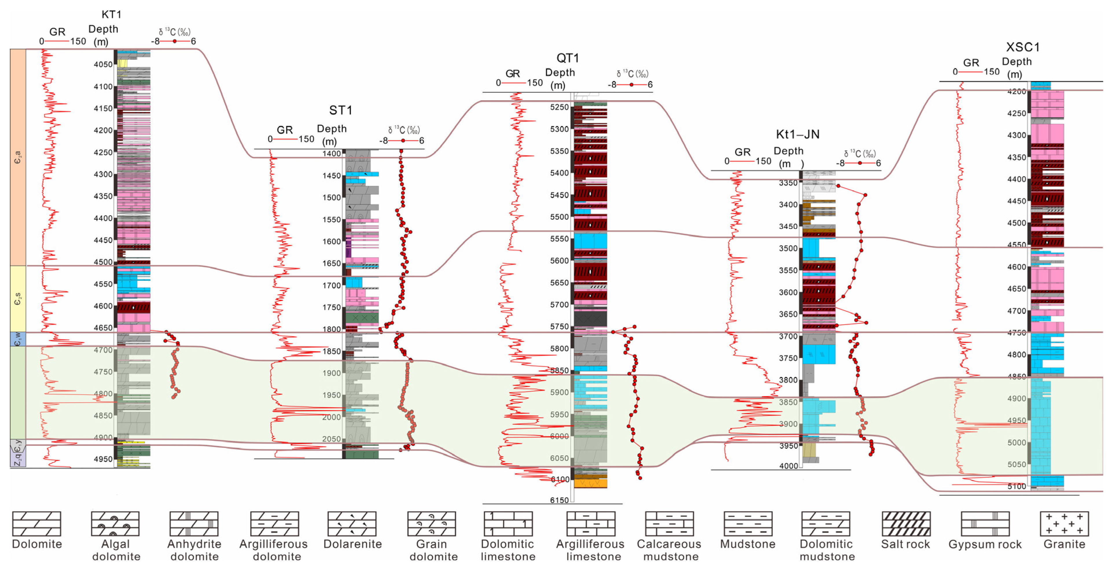
4.1.1. Basis for Drilling Formation Thickness

We conducted a systematic stratigraphic analysis of key drillings in the Keping–Wensu area. By comparing horizontal changes in the thickness of the Xiaoerbulak Formation, we identified a high-tectonic site in the Keping–Wensu area. In the SW–NE profile (Figure 3), the basement lithology of the Xiaoerbulak Formation in the KT 1JN Well consists of a set of gray to dark gray limestones, which are in sharp contact with a thin layer of black shales of the lower Yurtusi Formation, marked by high GR values on the logging curve. The Xiaoerbulak Formation’s thickness decreases from 214 m at Well KT 1 to 70 m at Well KT1-JN, and then increases to 223 m at Well XSC1. The overall thickness remains relatively stable with localized thinning, indicating a potential low paleo-uplift near Well KT1-JN.

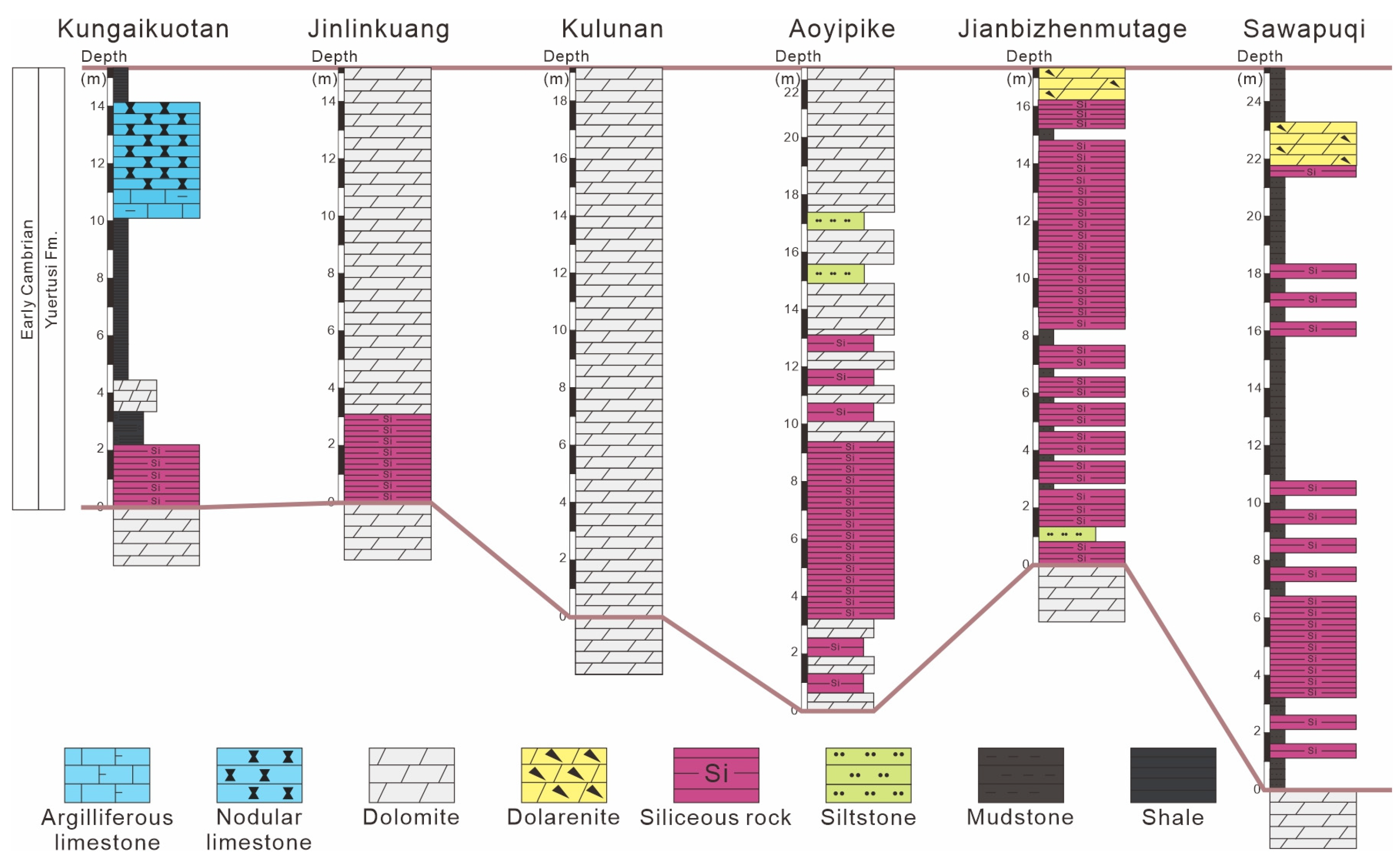
4.1.2. Basis for Field Outcrops

To further confirm the existence of the low paleo-uplift, we selected numerous field outcrop sections of the Cambrian in the Keping–Wensu area, where the stratigraphic depositional sequences show marked changes. The stratigraphic correlation of the Yurtusi Formation reveals that black shale is prevalent in the lower part of the formation in the southern Kungaikuotan section (Figure 4). The overall lithofacies have transitioned to siliceous dolomite of the Yurtusi Formation in the Kulunan section, located in the central part. However, in the Jinlinkuang, Aoyipike, and Jianbizhenmutage sections, the black shale of the Yurtusi Formation is absent, replaced by an interactive assemblage of siliceous and carbonate rocks. The lithofacies show dark mudstone interbedded with siliceous rocks from the Sawapuqi section. Stratigraphic correlation from the Aoyipike section to the Kungaikuotan section to the southwest confirms a gradual deepening water trend, aligning with the studies of the Yurtusi Formation’s sedimentary landforms [32]. This supports the viewpoint of a low paleo-uplift in the Jinlinkuang-Jianbizhenmutage outcrop area.
The stratigraphic thickness of seven outcrop sections of the Xiaoerbulak Formation in the study area was measured, and the results show that the average thickness of the Xiaoerbulak Formation is approximately 125.3 m. Among them, the Kungaikuotan section is the thickest, at 150.1 m, while the Aoyipike section is the thinnest, at 86.6 m (Figure 5). Based on characteristics such as rock color, rock type, rock association, sedimentary structure, and stratigraphic thickness, the Xiaoerbulak Formation can be divided into four submembers, from bottom to top, as follows: submember Xi 1, submember Xi 2, submember Xi 3, and submember Xi 4.
Taking the Kulunan section as an example (Figure 5), submember Xi 1, 32.6 m thick on average, is mainly composed of grayish-white thin-bedded micritic-silty crystalline dolomite and gray medium-bedded algal dolarenite with intra-stratal dissolved pores of millimeter scale. Submember Xi 2, 22.6 m thick on average, is characterized by blackish-gray, medium-bedded siliceous algal dolarenite with dissolved pores of millimeter scale. Submember Xi 3, 47.0 m thick on average, is divided into three subsegments, from bottom to top. The lower section of submember Xi 3 consists of gray thin- to medium-bedded thrombolite dolomite, intercalated with micritic-silty crystalline dolomite, with dissolved pores and vugs ranging from 2 to 5 cm in diameter, arranged parallel to the bedding plane. The middle section of submember Xi 3 consists of a set of grayish-white, thin-bedded micritic-silty crystalline dolomite. Dissolution pores are locally developed, but the overall structure is relatively dense. The upper section of submember Xi 3 consists of grayish-white, medium-bedded algal dolarenite intercalated with thrombolite dolomite and micritic dolomite, with intra-stratal dissolved pores of millimeter scale. Submember Xi 4, 23.1 m thick on average, is characterized by blackish-gray, thin-bedded laminal dolomite, interbedded with gray, medium-bedded algal dolarenite. Locally, it is intercalated with gray, thin-bedded micritic dolomite and thrombolite dolomite, which are relatively dense and have a high GR value in a serrated shape. They are different from the low-value and low-amplitude wavy GR characteristics of submembers Xi 1 and 2, and can be well-distinguished.
The stratigraphic correlation of the Xiaoerbulak Formation in Figure 5 shows a gradual decrease in the thickness of the Xiaoerbulak Formation from the Kungaikuotan section to the Aoyipike section. In particular, the stratigraphic thickness in the Aoyipike section shows overlapping and thinning. The thickness of the Xiaoerbulak Formation increases again to 146.2 m in the Jianbizhenmutage section, and then gradually decreases to 123.2 m in the Sawapuqi section. Additionally, the middle and lower parts of the Xiaoerbulak Formation in the Kungaikuotan and Sawapuqi sections are located in a low-energy background of a middle-ramp limy dolomitic flat, with deep sedimentary water bodies. Localized clastic rock lenses (Figure 6A) and purplish-red argillaceous carbonate rocks (Figure 6B) indicate a low uplift background in the Early Cambrian. Diamictite samples, lately acquired from the Aoyipike section, also indicate that the water is shallow and has a little overall variation (Figure 6C,D), further supporting the speculation that low paleo-uplift developed during this period.

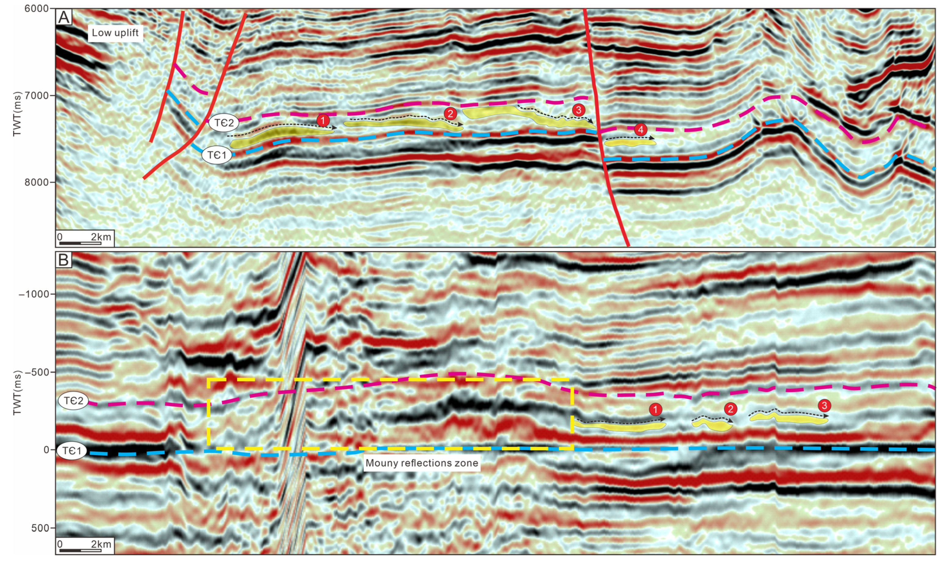
4.1.3. Basis for Seismic Profile

Based on drilling and outcrop data, over 20 3D seismic data in the study area were interpreted in detail by selecting several horizontal and vertical seismic lines around the Wensu low paleo-uplift (Figure 7). Then, combining well-seismic calibration and coupling analysis of multiple survey lines, the 3D seismic reflection data are tracked and identified on the horizon in detail. Additionally, we interpreted a foreset reflection belt around the Keping–Wensu area in the east. Within the foreset reflection belt, we observed parallel and moundy reflections, characterized by localized multiple progradation configurations. These represent large-scale, high-energy facies belts’ responses, spanning 5 to 8 km in width, 45 km in length, and approximately 300 km2. High-energy facies belts may be caused by differences in water energy due to low uplift, which further leads to more pronounced facies belt differentiation. From these observations, we concluded that a low uplift, which dominated sedimentation in Keping–Wensu, turned up in the Early Cambrian Epoch.

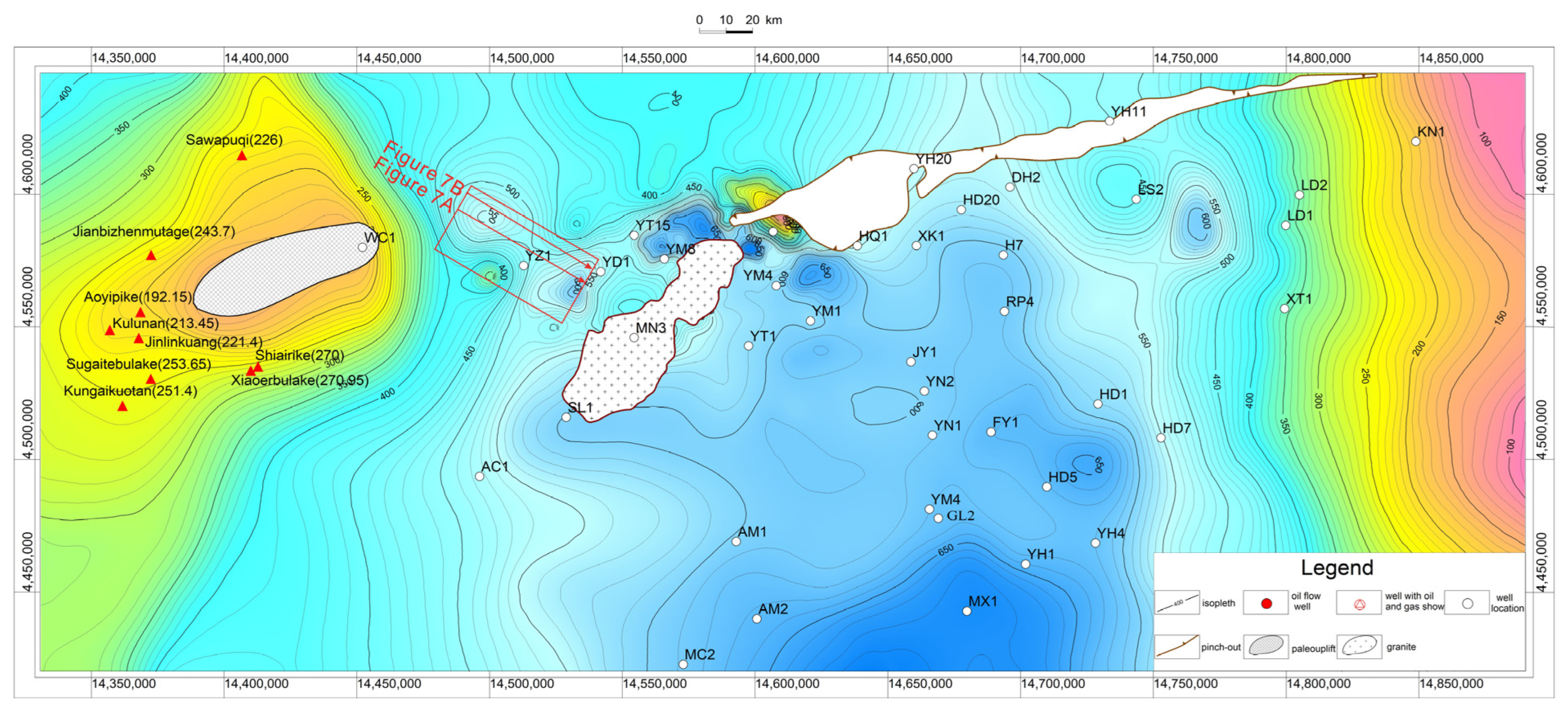
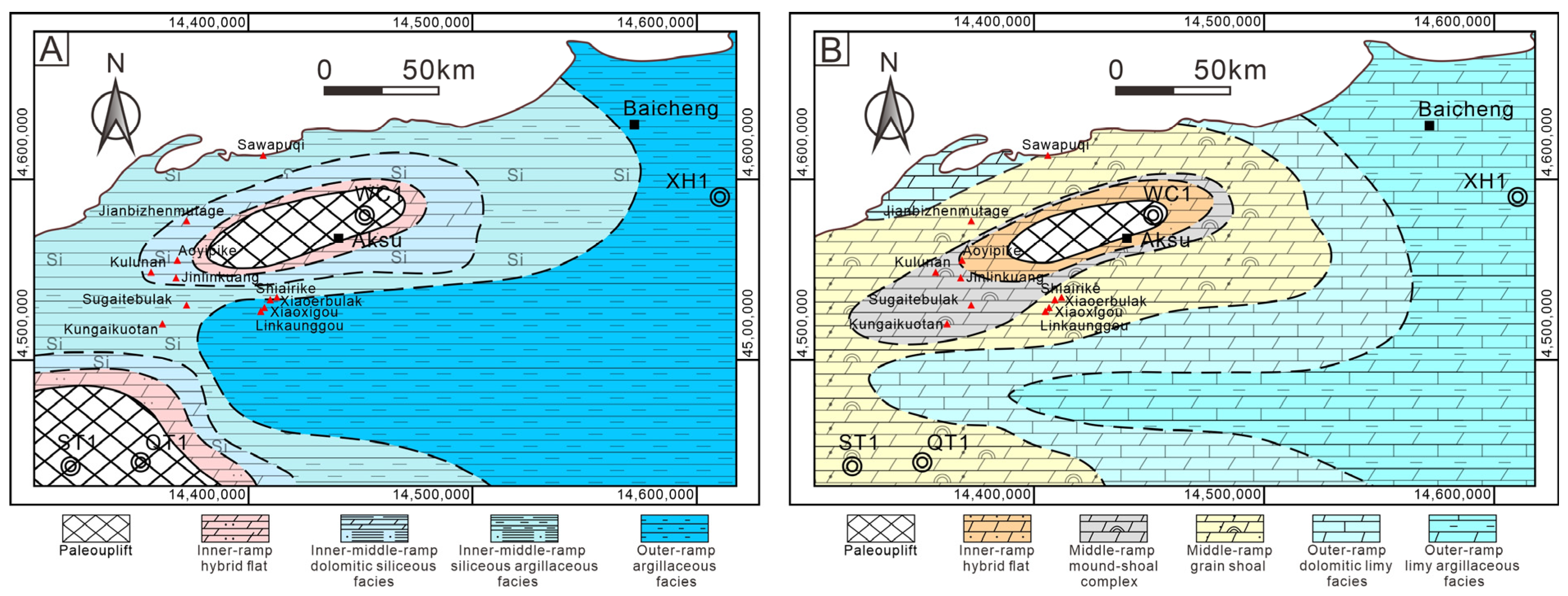
4.2. The Distribution of the Wensu Low Paleo-Uplift

Based on the field outcrop and drilling data, combined with the recently spliced grid seismic profile, the thickness distribution map of the Lower Cambrian in the Tarim Basin is compiled. The formation thickness during this depositional period accurately reflects the planar distribution characteristics of the Wensu low paleo-uplift. Figure 8 illustrates that the Lower Cambrian strata gradually thin in the Keping–Wensu area, but significantly thicken to the south and north. Overall, the overlap and thinning from inter-uplift sag to the uplift area, are characterized by inheriting the thin thickness of the paleo-uplift within the basin, and the thick thickness of inter-uplift sag. Based on this, the distribution boundary of the Wensu low paleo-uplift can be preliminarily delineated. The planar distribution of the Wensu low paleo-uplift is generally shown as a SW–NE trending nose structure, extending roughly 114 km in length to the southwest, about 35 km in width to the northeast. Generally, it features a high western and a low eastern side, almost parallel to the Southwest Tarim uplift.

5. Discussion

5.1. Formation and Evolution of the Uplift–Depression Framework

5.1.1. Formation and Extinction of the Paleo-Uplift

From the beginning of the Nanhuan Period to the Early Lower Paleozoic, the Tarim Basin experienced strong regional extensional tectonic activities. These movements were deeply connected with the aggregation and breakup of Rodinia and Gondwanaland [24,33,34,35]. Extensive petrological, chronological, and geochemical evidence supports this connection [36]. For example, ages indicative of the early and late stages of the breakup were recorded at 760 Ma in the lower Nanhuan, and 615 Ma in the lower Sinian [34,37]. Following the breakup of the Rodinia supercontinent, the Tarim plate gradually separated from adjacent landmasses [24,38]. Meanwhile, basalt of rift facies forming in the plate indicated the transition to a rift basin, with the whole process composed of the initial stage of rift growing (at the beginning of the Nanhuan Period), rift-depression transformation (in the Late Sinian Period), and post-rift subsidence and craton (in the Cambrian Period) (Figure 9) [38,39,40].
The development of the rift system and the highly uplifted zones in the north and south constituted the paleotectonic framework with two uplifts and two depressions in the Tarim plate. Among them, the two uplifts refer to the Tabei basement paleohigh and the central basement paleohigh, while the depressions include the northern depression and the southwestern Tarim depression. By the end of the Sinian period, the Tarim plate was uplifted as a whole, and Nanhuan–Sinian formations were denuded in the whole basin due to the influence of the Keping movement, with the periphery entering a development stage of passive continental margin. The southwestern part of Tarim can be further divided into the Tanan uplift and the Uqia uplift during the depositional period. However, the Tabei basement paleohigh is relatively high near the Wensu region, and evolved into the Early Cambrian Wensu low paleo-uplift (Figure 9). Due to the differences in the impact strength of the Keping movement on the Tarim plate, the uplift amplitude of the Tabei basement paleohigh in the Keping–Wensu area is greater than that in the Lunnan area, laying the foundation for the paleotectonic framework of the Cambrian, with topographic high in the south, and topographic low in the north [41]. The reason why the Wensu paleo-uplift is defined as a low uplift area in this study is because of the overall absence of the Yurtusi Formation in the core areas of the Tanan and Uqia paleo-uplifts, while the Yurtusi Formation is deposited in the Keping–Wensu area. Despite its small thickness and distinct phase transitions, it can still clearly indicate that the terrain during the depositional period was lower than in the Tanan and Uqia paleo-uplift areas (Figure 9).
During the Early Cambrian period, the Yurtusi, Xiaoerbulak, and Wusonger Formations were successively deposited, overlapping from the paleo-rift zone to adjacent paleohighs. The paleotectonic framework, with three paleohighs and two topographic lows, was further differentiated within the basin. In the Middle Cambrian, with the development of the “bucket-like” structure of the platform and the arid hot paleoclimate, the ramps and rimmed carbonate platforms developed, and the uplift–depression framework basically died out (Figure 9).

5.1.2. Formation and Extinction of the Uplift-Sag Framework

The breakup of the Rodinia supercontinent formed two major paleo-rifts, with well-developed graben–horst structures within the rifts. Vertically, it went through the following three stages: a rift in the Nanhua, an embryonic passive continental margin in the Sinian, and a stable passive continental margin in the Cambrian, during which it experienced multiple active and intermittent periods [40]. Influenced by the activities of the Awati–Manjar rift system and the southwestern Tarim rift system, inter-uplift sags were formed between the Tanan paleo-uplift, the Uqia paleo-uplift, the central paleo-uplift, and the Tabei basement paleo-uplift, while the Manjar rift evolved into an eastern basin. The Awati sag, located in the southern part of the Wensu low paleo-uplift, served as the sedimentary center for the northern sag during the Wusonger Formation depositional period. Limy mudstone, argillaceous limestone, and micritic dolomite with a thickness of over 150 m were developed, gradually transforming into thick micritic limestone towards Well XH1 in the east. The Awati–XH1 Well area extends nearly east–west, featuring a north–south differentiation within the platform’s overall framework. The development of the eastern basin primarily results from the rapid subsidence rate of the early Manjar paleo-rift, and the activation of early large faults. The sedimentary layers are relatively thin, primarily composed of dark gray and black mudstone, along with micritic limestone deposits.

5.2. Formation and Evolution of the Uplift–Depression Framework

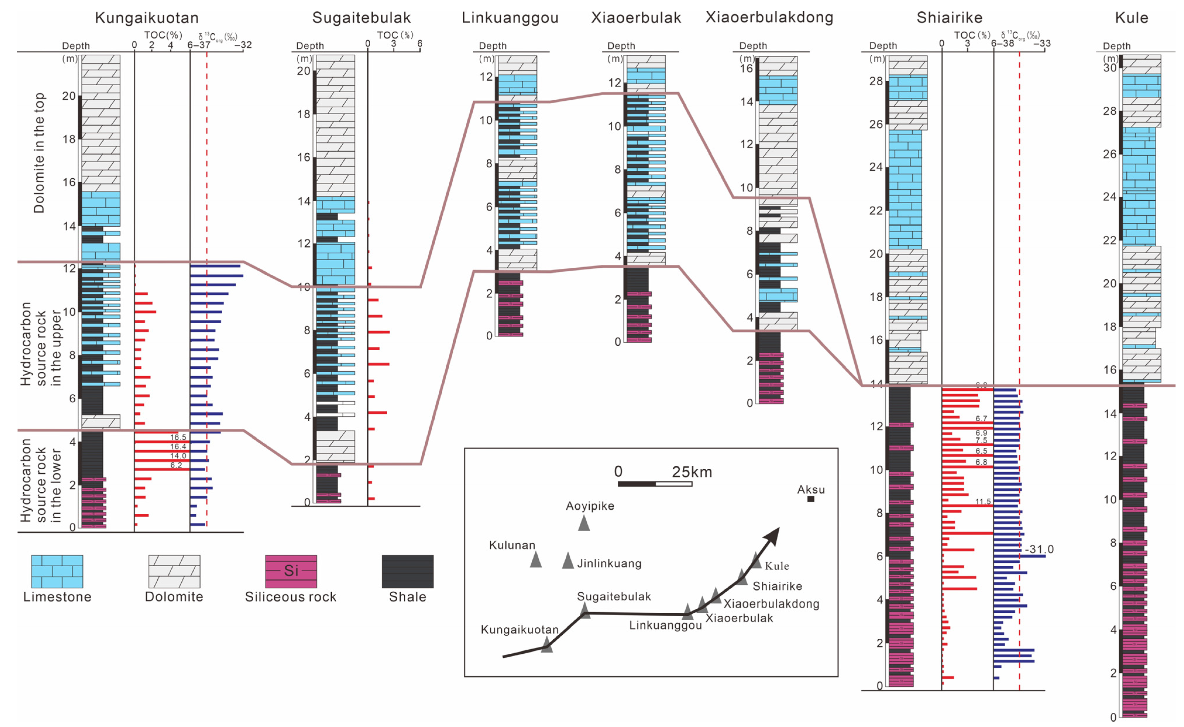
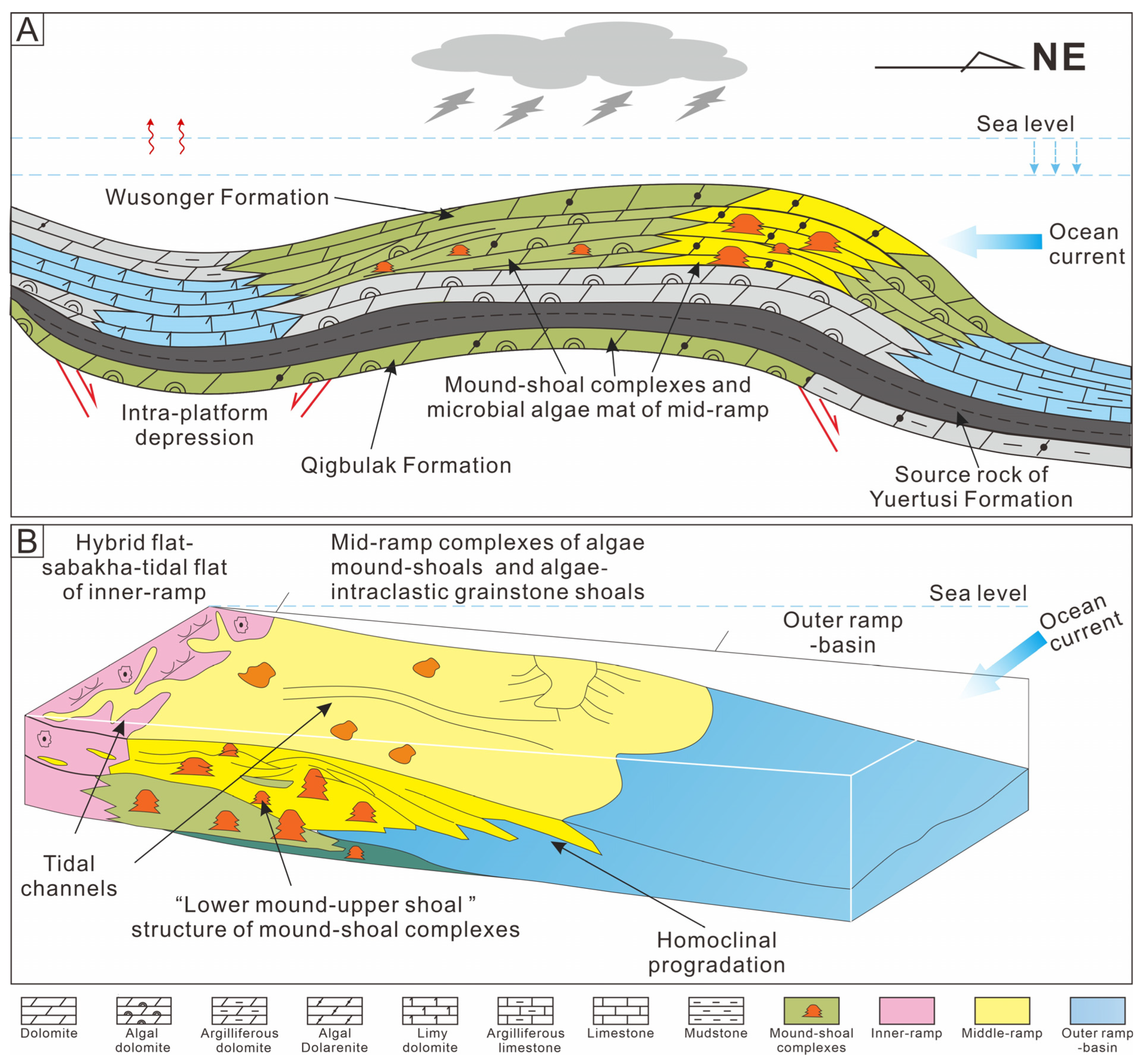
5.2.1. Control of the Development and Distribution of Source Rocks

At the end of the Sinian period, despite varying degrees of denudation of the Upper Sinian formation due to the influence of the Keping movement, the uplift–depression framework has been well-preserved since the Nanhuan period, forming the paleogeomorphology of the Early Cambrian Yurtusi Formation. Exploration practice has shown that the Yurtusi Formation has been encountered in six exploratory wells. Additionally, the high-quality source rocks of the Early Cambrian Yurtusi Formation were revealed in twelve outcrop sections in the Keping–Wensu area [42], with the thickness gradually thinning towards the Wensu low uplift area. Comprehensive analysis suggests that the depositional stage of the Early Cambrian Yurtusi Formation, characterized by argillaceous ramps, was controlled by the sustained subsidence of the Precambrian uplift–depression framework, divided into three facies zones, as follows: inner-ramp, middle-ramp, and outer-ramp (Figure 10A). Among them, the inner-ramp, primarily distributed on the north side of the central paleohigh, and around the Keping–Wensu low uplift, consists mainly of interbedded clastic rocks, sandy dolomite, and mudstone, occurring chiefly in the Laozhuanchang section and Well ST1. The middle-ramp, primarily distributed on the north side of the central paleohigh, around the Keping–Wensu low uplift and Lunnan, consists of argillaceous dolomite, grayish-black shale, and argillaceous (nodular) limestone associations, observed in the Sugaitebulak and Xiaoerbulak sections. The outer-ramp primarily occupies the area east of the Lunnan–Gucheng platform zone. It consists of black shale, siliceous mudstone, and siliceous rock, indicative of deep-sea basin features, as observed in Well XH1.
Through observation and measurement of nine field section points, including Sugaitebulak, Xiaoerbulak, and Shiairike, as well as Well XH1, in Keping outcrops, the Yurtusi Formation is categorically divided from bottom to top into three submembers. These include the lower submember, comprising rich siliceous source rocks, followed by the middle submember, where upper source rocks frequently interleave with thin layers of limestone and dolomite, and concluding with the top submember, characterized by dolomite. The formation progresses vertically into an upward shallowing sequence, with total thicknesses between 30 m and 50 m, and the accumulated thickness of the black shale spanning from 10 m to 15 m (Figure 11).

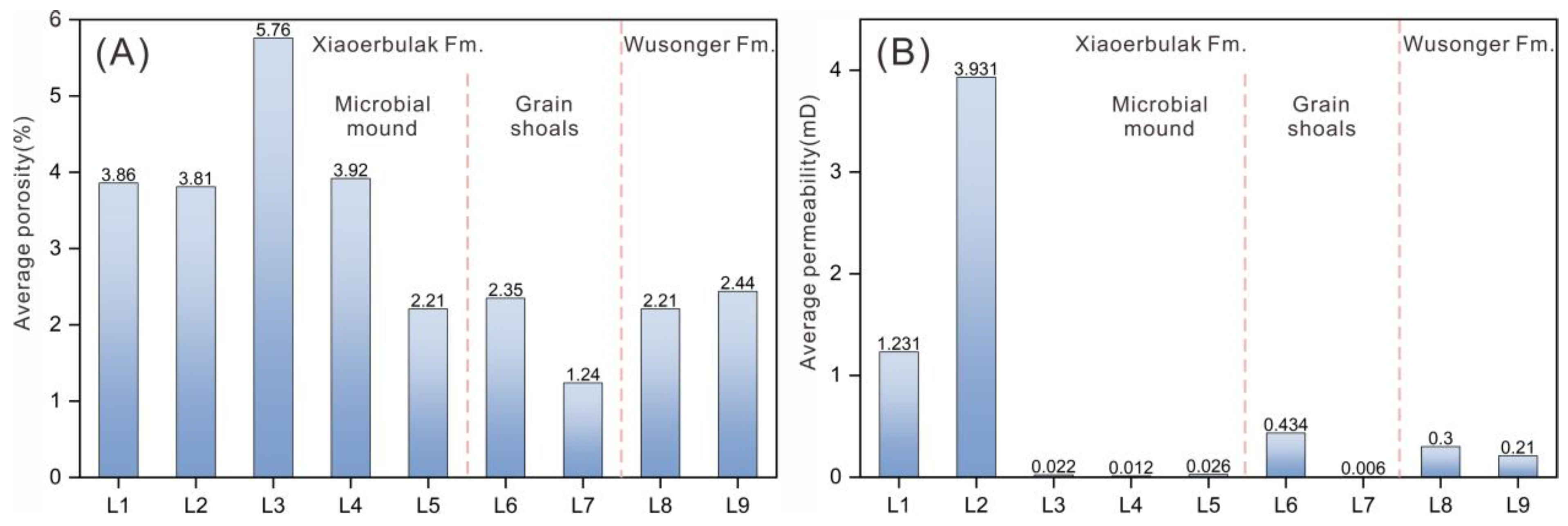
5.2.2. Control of the Development and Distribution of Reservoir Rocks

After the “filling and leveling” effect during the Yurtusi Formation period and the differential subsidence caused by local fault activation, the Tarim Basin was widely deposited with ramp-type carbonate platforms during the Early Cambrian Xiaoerbulak Formation depositional period. The uplift–depression framework was further differentiated in the Keping–Wensu area, with deposits of the Xiaoerbulak Formation overlying the paleo-uplift zone and gradually thinning towards the Keping–Wensu low uplift zone. The paleo-uplift continues to control the lithofacies paleogeography differentiation of this period. Ancient ocean currents influencing the Tarim plate in the Early Cambrian moved NE–SW, influenced by the ancient uplift–depression structure, resulting in lower water energy in the Keping–Wensu area [43]. The west side of the Keping–Wensu area was mainly deposited as a homoclinal ramp with mound-shoal complexes due to low–medium water energy. The paleohigh, inner-ramp hybrid flat, inner-ramp tide flat, middle-ramp mound-shoal complexes, middle-ramp grain shoal, outer-ramp dolomitic limy facies/limy argillaceous facies, and basin occur in succession on the north of the paleohigh (Figure 10B).
In the middle–late stage of the Xiaoerbulak Formation, the inner- to middle-ramp mound-shoal complex is the most representative facies zone in such a ramp type, and it is characterized by unequally sized microbial mounds overlain by quasi-bedded algal fragment shoals. Occasionally, some small microbial mounds appear embedded within larger algal fragment shoals, forming a “small mounds and large shoals” structure (Figure 12A,B). Mound-shoal complexes form the primary material basis for reservoirs, serving as effective carriers with good quality and extensive distribution. Such mound-shoal complexes were revealed from the Kungaikuotan to Sawapuqi profiles in Keping–Wensu area outcrop sections, mainly developed in the upper-middle section of the Xiaoerbulak Formation, especially in the Kungaikuotan, Sugaitebulak, and Jianbizhenmutage sections (Figure 5). The lower part of the microbial mounds’ reservoirs consists of algal thrombolite dolomites (Figure 13A), spongiostromata dolomites (Figure 13B), algal framework dolomites (Figure 13C), and stromatolite dolomites (Figure 13D). The reservoir space is dominated by primary pores, mainly algal framework pores (Figure 13A,B). The average porosity ranges from 2.21% to 5.76%, and the average permeability is 0.012 mD to 3.931 mD, among which algal thrombolite dolomites have better physical properties, with an average porosity of 3.81% and a permeability of 3.931 mD (Table 1; Figure 14A,B). Reservoirs in overlying grain shoals mainly consist of algal dolarenite (Figure 13D,E), bound grain dolomites, and crystalline (residual) grain dolomites (Figure 13F). The reservoir space is primarily characterized by intergranular (dissolved) pores and intercrystalline pores (Figure 13E,F). The average porosity ranges from 1.24% to 2.35%, and the average permeability is 0.006 mD to 0.434 mD, among which algal dolarenites have better physical properties, with an average porosity of 2.35% and a permeability of 0.434 mD (Table 1; Figure 14A,B). Overall, they constitute the main part of the high-quality reservoirs, and can serve as a good reservoir.
Based on the macroscopic and microscopic characteristics of the Xiaoerbulak Formation reservoir and previous research results [44], it is shown that the main diagenesis types in the study area include predominantly micritization (Figure 13E), dolomitization (Figure 13B), recrystallization (Figure 13B–E,G), dissolution (Figure 13A,H,I), cementation (Figure 13C,D,J), compaction and solution, and fracturing (Figure 13H). These processes occurred during the submarine, meteoric water of the early supergene stage, shallow burial, and middle-to-deep burial diagenetic environments. The diagenetic evolution sequence is as follows: initial sedimentation; marine cementation; meteoric water eluviation of early supergene stage; seepage reflux dolomitization of penecontemporaneous and shallow burial stages; gypsum precipitation; compaction and solution; burial dolomitization; recrystallization; fracturing I (tensile fractures generated during tectonic uplift); burial dissolution; fracturing I (cracks generated by stress release during burial); and hydrothermal alteration.
During the depositional period of the Wusonger Formation, the Keping–Wensu low uplift still existed, and it controlled the differentiation within the platform. Compared to the typical homoclinal ramp-type platform of the Xiaoerbulak Formation, the Wusonger Formation gradually evolved towards a weakly rimmed carbonate platform during the depositional period. The hybrid tide flats and grain shoals form the primary material basis for reservoir development. The reservoir lithology is mainly composed of micritic to finely crystalline dolomites (Figure 13G,H) and grain dolomite. The reservoir space is dominated by intercrystalline dissolved pores and intergranular dissolved pores (Figure 13G,H). The average porosity ranges from 2.21% to 2.44%, and the average permeability is 0.21 mD to 0.3 mD (Table 1; Figure 14A,B); both have certain reservoir performances.

5.2.3. The Significance of Source–Reservoir Controlling and Exploration

The tectonic-sedimentary evolution of the uplift–depression framework controlled the development of a set of main source rocks and two sets of large-scale effective reservoir rocks in the Lower Cambrian, which, together with the large-scale microbial mound dolomite reservoirs in the Upper Sinian Qigbulak Formation and the high-quality cap of gypseous salt rocks in the Middle Cambrian, constitute two sets of effective hydrocarbon accumulation in the upper and lower stratigraphic parts of the basin (Figure 12A). The lower assemblage consists of the Upper Sinian microbial mound-shoal dolomite reservoirs and the Lower Cambrian Yurtusi argillaceous cap rocks. The composition of the lower assemblage includes Upper Sinian microbial mound-shoal dolomite reservoirs and Lower Cambrian Yurtusi argillaceous cap rocks. Conversely, the upper assemblage is formed by Lower Cambrian Yurtusi source rocks, Xiaoerbulak mound-shoal complex reservoirs, Wusonger grain shoal reservoirs, and Middle Cambrian gypseous salt cap rocks. Discoveries of oil and gas have been reported in both assemblages (Figure 12A).
In the Early Cambrian, the Wensu low uplift was characterized by paleohigh conditions during the Late Hercynian. This period aligned with a significant phase of hydrocarbon accumulation that was prevalent across both the upper and lower reservoir assemblages [45]. The Qigbulak microbial mound-shoal dolomite reservoirs in the lower assemblage are characterized by their considerable thickness and favorable properties. In contrast, the Xiaoerbulak mound-shoal complex dolomite reservoirs in the upper assemblage developed in a wider and gentler paleogeomorphic environment, leading to superior scale and quality compared to the Qigbulak Formation (Figure 12A). This superior quality is closely related to the wide and gentle paleogeomorphology formed by the erosion and leveling of the Keping movement, and the further “filling and leveling” effect during the Yurtusi Formation period [46,47].
Additionally, the widespread development of high-quality source rocks in the Lower Cambrian Yurtusi Formation ensures a reliable source rock supply for two effective oil and gas reservoir assemblages. Exploration practice has proven that, nowadays, the favorable area with the buried depth < 8500 m covers an area of 27,262 km2, 682 km2 for the lower assemblage, and 26,580 km2 for the upper assemblage [25]. These data also further indicate that the upper assemblage holds more exploration potential, and is expected to be a pivotal breakthrough point in the hydrocarbon exploration of Cambrian subsalt in the Keping–Wensu area.

6. Conclusions

  • Based on drilling data, field outcrops evaluations, thin section analysis, and 3D seismic data, Wensu low paleo-uplift was discovered in the Keping–Wensu area of the Tarim Basin. The planar distribution of the Wensu low paleo-uplift is typically demonstrated as a SW–NE trending nose structure, characterized by a far SW-trending extension, a narrow NE-trending extension, and an overall characteristic of being higher in the west and lower in the east.
  • At the end of the Sinian period, the Tarim plate was uplifted as a whole, and Nanhuan–Sinian formations were denuded in the whole basin due to the influence of the Keping movement. In the Early Cambrian, the Tabei paleo-uplift evolved into the Wensu low paleo-uplift, which basically died out in the Middle Cambrian.
  • In the Early Cambrian, the Wensu paleo-uplift controlled the development of high-quality source rocks in the Yurtusi Formation. The contemporaneous paleotectonic framework also controlled the formation of mound-shoal complexes and grain shoals, laying the foundation for high-quality reservoirs in the Xiaoerbulak and Wusonger Formations. Effective source–reservoir–cap assemblages were developed in the paleo-uplift area, constituting two sets of effective hydrocarbon accumulations in the upper and lower stratigraphic parts of the basin. The upper assemblage holds greater exploration potential, and is expected to be a next strategic target area for hydrocarbon exploration of Cambrian subsalt in the Keping–Wensu area.

Author Contributions

Conceptualization, Y.Z., J.Z. and C.C.; methodology, Y.Z. and J.Z.; investigation, Y.Z., J.Z. and Q.L.; data curation, Y.Z., Q.L., H.T., T.K. and T.Z.; writing—original draft preparation, Y.Z., H.T., T.K., T.Z. and L.H.; writing—review and editing, J.Z.; visualization, T.K. and T.Z.; supervision, Y.Z. and J.Z.; project administration, J.Z. All authors have read and agreed to the published version of the manuscript.

Funding

The research was co-funded by the PetroChina Science and Technology Major Project (Research on Hydrocarbon Accumulation and Preservation Mechanisms of the Middle and Lower Assemblages of Superimposed Basins in China, No. 2023ZZ02) and the PetroChina Science and Technology Major Project (Research on the Enrichment Regularities and Favorable Zones of Oil and Gas in Carbonate Rocks, No. 2023ZZ16YJ01).

Data Availability Statement

Data are contained within the article.

Acknowledgments

We are very grateful to anonymous reviewers and editor(s) for their very useful comments on the manuscript.

Conflicts of Interest

Though some of the co-authors are employees of companies. The paper reflects the views of the scientists and not the company.

References

  1. He, D.F.; Li, D.S.; Wu, X.Z.; Wen, Z. Basic types and structural characteristics of uplifts: An overview of sedimentary basins in China. Acta Geol. Sin. 2009, 83, 321–346. [Google Scholar] [CrossRef]
  2. Jiao, Z.F.; Gao, Z.Q. Formation, Evolution and Hydrocarbon-Controlling Geological Conditions of Major Paleohighs, Tarim Basin. Nat. Gas Geosci. 2008, 19, 639–646, (In Chinese with English Abstract). [Google Scholar]
  3. Yan, J.K.; Chen, H.L.; Cheng, X.G.; Chen, Y.Q.; Zeng, C.M.; Chen, C.; Wu, H.X. Migration of paleo-uplift in southwestern Tarim Basin and its implications for orogenesis and reservoir development, NW China. Petrol. Explor. Dev. 2023, 50, 99–110. [Google Scholar] [CrossRef]
  4. Goswami, P.K.; Pant, C.C.; Pandey, S. Tectonic controls on the geomorphic evolution of alluvial fans in the piedmont zone of ganga plain, uttarakhand, India. J. Earth Syst. Sci. 2009, 118, 245–259. [Google Scholar] [CrossRef]
  5. Xu, G.F.; Lin, C.S.; Liu, Y.F.; Sun, Q. Evolution of palaeo-uplift and its controlling on sedimentation of Kapushaliang Group of early cretaceous in western Tabei uplift. Earth Sci. 2016, 41, 619–632, (In Chinese with English Abstract). [Google Scholar]
  6. Ji, Y.L.; Zhou, Y.; Kuang, J.; Wan, L.; Zhang, R.; Lu, C.H. The formation and evolution of Chepaizi-Mosuowan paleo-uplift and its control on the distributions of sedimentary facies in the Junggar Basin. Sci. China Earth Sci. 2010, 53, 818–831. [Google Scholar] [CrossRef]
  7. Gao, C.L.; Ji, Y.L.; Ren, Y.; Zhou, Y.; Jin, J.; Zhang, L.Y.; Li, Z.C.; Zhou, Y.Q.; Wu, H. Geomorphology and sedimentary sequence evolution during the buried stage of paleo-uplift in the Lower Cretaceous Qingshuihe Formation, Junggar Basin, northwestern China: Implications for reservoir lithofacies and hydrocarbon distribution. Mar. Pet. Geol. 2017, 86, 1224–1251. [Google Scholar] [CrossRef]
  8. Lin, D.L.; Xi, Z.D.; Tang, S.H.; Lash, G.G.; Guo, Q.L.; Wang, H.Y.; Zhu, Y.M. Organic matter enrichment in shale deposited proximal to paleo-uplifts and its impact on shale gas exploration. Palaeogeogr. Palaeocl. 2024, 633, 111900. [Google Scholar] [CrossRef]
  9. Liu, J.Y.; Steel, R.J.; Lin, C.S.; Yang, H.J.; Yang, Y.H.; Peng, L.; Gong, Y.; Chu, C.L. Geomorphology control on the development of reservoir depositional systems, devonian donghetang Formation in the Tabei uplift of the Tarim Basin, China. Mar. Pet. Geol. 2012, 38, 177–194. [Google Scholar] [CrossRef]
  10. Li, J.T.; Wang, R.; Qin, S.; Shi, W.Z.; Geng, F.; Luo, F.S.; Li, G.P.; Zhang, X. Evolution of Mesozoic paleo-uplifts and differential control on sedimentation on the southern margin of Kuqa Depression, Tarim Basin. Mar. Pet. Geol. 2024, 161, 106707. [Google Scholar] [CrossRef]
  11. Kingston, D.R.; Dishroon, C.P.; Williams, P.A. Global basin classification system. AAPG Bull. 1983, 67, 2175–2193. [Google Scholar]
  12. Liang, X.P.; Jin, Z.J.; Philippov, V.; Obryadchikov, O.; Zhong, D.K.; Liu, Q.Y.; Uspensky, B.; Morozov, V. Sedimentary characteristics and evolution of Domanik facies from the Devonian–Carboniferous regression in the southern Volga-Ural Basin. Mar. Pet. Geol. 2020, 119, 104438. [Google Scholar] [CrossRef]
  13. Li, W.; Yi, H.Y.; Hu, W.S.; Yang, C.; Xiong, X. Tectonic evolution of Caledonian palaeohigh in the sichuan Basin and its relationship with hydrocarbon accumulation. Nat. Gas. Ind. B 2014, 1, 58–65. [Google Scholar]
  14. Wei, G.Q.; Yang, W.; Du, J.H.; Xu, C.C.; Zou, C.N.; Xie, W.R.; Wu, S.J.; Zeng, F.Y. Tectonic features of Gaoshiti-Moxi paleo-uplift and its controls on the formation of a giant gas field, Sichuan Basin, SW China. Petrol. Explor. Dev. 2015, 42, 283–292. [Google Scholar] [CrossRef]
  15. Qin, S.; Shi, W.Z.; Wang, R.; Liu, K.; Zhang, W.; Qi, R.; Xu, Q.H. Characteristics of Tight Sandstone Reservoirs and Their Controlling Factors of He-1 Member in Hangjinqi Block, Ordos Basin. Earth Sci. 2022, 47, 1604–1618, (In Chinese with English Abstract). [Google Scholar]
  16. Yuan, H.; Yin, S.; Dong, L.; Tan, C.Q. Restoration of the pre-Jurassic paleogeomorphology and its control on hydrocarbon distribution in western Ordos Basin. Energy Geosci. 2022, 3, 485–494. [Google Scholar] [CrossRef]
  17. Mao, D.F.; He, D.F.; Bao, H.P.; Wei, L.B.; Xu, Y.H.; Cheng, X.; Gou, J.Y.; Wu, S.J. Distribution, evolution and structural properties of Wushenqi paleo-uplift in Ordos Basin, NW China. Petrol. Explor. Dev. 2023, 50, 865–877. [Google Scholar] [CrossRef]
  18. Yue, Y.; Tian, J.C.; Zhao, Y.Q.; Wang, M.; Xie, P.Y. Control of Hetian Paleo-Uplift on Hydrocarbon Accumulation of Ordovician, Tarim Basin. Earth Sci. 2018, 43, 4215–4225, (In Chinese with English Abstract). [Google Scholar]
  19. Zhang, Z.Y.; Zhu, G.Y.; Zhang, Y.J.; Han, J.F.; Li, T.T.; Wang, E.Z.; Greenwood, P. The origin and accumulation of multi-phase reservoirs in the east Tabei uplift, Tarim Basin, China. Mar. Pet. Geol. 2018, 98, 533–553. [Google Scholar] [CrossRef]
  20. Liu, Y.L.; Gao, Y.J.; Zhang, J.F.; Bai, Z.K.; Cheng, M.H.; Zhang, Y.Y.; Yang, Y.X. New understanding of tectonic characteristic of the Wensu salient in Tarim Basin. Acta Pet. Sin. 2022, 38, 2665–2680, (In Chinese with English Abstract). [Google Scholar]
  21. Zhang, J.F.; Gao, Y.J.; Yang, Y.X.; Zhou, X.G.; Zhang, J.H.; Zhang, Y.Y. Oil exploration breakthrough in the Wensu salient, northwest Tarim Basin and its implications. Petrol. Explor. Dev. 2019, 46, 16–26. [Google Scholar] [CrossRef]
  22. Zhu, Y.J.; Zheng, J.F.; Cao, P.; Qiao, Z.F.; Yu, G.; Liu, L.L.; Huang, L.L. Tectonic-Lithofacies Paleogeography and Sizeable Reservoir Potential in the Early Cambrian Postrift Depressed Carbonate Ramp, Tarim Basin, NW China. Lithosphere 2021, 8804537. [Google Scholar] [CrossRef]
  23. Wu, G.Y.; Li, Y.J.; Liu, Y.L.; Zhao, Y. Paleozoic sedimento-tectonic evolution and basin dynamic settings in Wushi-Kalpin-Bachu area, northwest Tarim. J. Palaeogeogr. 2013, 15, 203–218, (In Chinese with English Abstract). [Google Scholar]
  24. Lin, C.S.; Li, S.T.; Liu, J.Y.; Qian, Y.X.; Luo, H.; Chen, J.Q.; Peng, L.; Rui, Z.F. Tectonic framework and paleogeographic evolution of the Tarim basin during the Paleozoic major evolutionary stages. Acta Pet. Sin. 2011, 27, 210–218, (In Chinese with English Abstract). [Google Scholar]
  25. Wei, G.Q.; Zhu, Y.J.; Zheng, J.F.; Yu, G.; Ni, X.F.; Yan, L.; Tian, L.; Huang, L.L. Tectonic-lithofacies paleogeography, large-scale source-reservoir distribution and exploration zones of Cambrian subsalt formation, Tarim Basin, NW China. Petrol. Explor. Dev. 2021, 48, 1289–1303. [Google Scholar] [CrossRef]
  26. Liu, W.; Zhang, G.Y.; Pan, W.Q.; Deng, S.H.; Li, H.H. Lithofacies palaeogeography and sedimentary evolution of the Cambrian in Tarim area. J. Palaeogeogr. 2011, 13, 529–538, (In Chinese with English Abstract). [Google Scholar]
  27. Pan, W.Q.; Chen, Y.Q.; Xiong, Y.X.; Li, B.H.; Xiong, R. Sedimentary facies research and implications to advantaged exploration regions on Lower Cambrian source rocks, Tarim basin. Oil Gas Geol. 2015, 26, 1224–1232, (In Chinese with English Abstract). [Google Scholar]
  28. Zhu, D.; Meng, Q.; Jin, Z.; Liu, Q.; Hu, W. Formation mechanism of deep Cambrian dolomite reservoirs in the Tarim basin, northwestern China. Mar. Pet. Geol. 2015, 59, 232–244. [Google Scholar] [CrossRef]
  29. Du, J.H.; Pan, W.Q. Accumulation conditions and play targets of oil and gas in the Cambrian subsalt dolostone, Tarim Basin, NW China. Petrol. Explor. Dev. 2016, 45, 1111–1126, (In Chinese with English Abstract). [Google Scholar]
  30. Wang, Z.; Gao, Z.; Fan, T.; Shang, Y.; Qi, L.; Yun, L. Structural characterization and hydrocarbon prediction for the SB5M strike-slip fault zone in the Shuntuo Low Uplift, Tarim Basin. Mar. Pet. Geol. 2020, 117, 104418. [Google Scholar] [CrossRef]
  31. Deng, S.; Liu, Y.Q.; Liu, J.; Han, J.; Wang, B.; Zhao, R. Structural styles and evolution models of intracratonic strike-slip faults and the implications for reservoir exploration and appraisal: A case study of the Shunbei area, Tarim Basin. Geotecton. Metal. 2020, 45, 1111–1126, (In Chinese with English Abstract). [Google Scholar]
  32. Zhu, G.Y.; Cheng, F.R.; Chen, Z.Y.; Zhang, Y.; Xing, X.; Tao, X.W.; Ma, D.B. Discovery and basic characteristics of the high-quality source rocks of the Cambrian Yuertusi Formation in Tarim Basin. Nat. Gas. Geosci. 2016, 27, 8–21, (In Chinese with English Abstract). [Google Scholar] [CrossRef]
  33. Zhai, M.G. The main old lands in China and assembly of Chinese unified continent. Sci. China Earth Sci. 2013, 56, 1829–1852. [Google Scholar] [CrossRef]
  34. Wu, G.H.; Li, H.W.; Xu, Y.L.; Su, W.; Chen, Z.Y. The tectonothermal events, architecture and evolution of Tarim craton basement palaeo-uplifts. Acta Pet. Sin. 2012, 28, 2435–2452, (In Chinese with English Abstract). [Google Scholar]
  35. Li, Z.X.; Powell, C.M.A. An outline of the palaeogeographic evolution of the Australasian region since the beginning of the Neoproterozoic. Earth Sci. Rev. 2001, 53, 237–277. [Google Scholar] [CrossRef]
  36. Wu, L.; Guan, S.W.; Feng, X.Q.; Ren, R.; Zhang, C.Y. Discussion on stratigraphic division of the Nanhuan and Sinian of the Tarim Basin and its surrounding region. Acta Petrol. Sin. 2020, 36, 3427–3441, (In Chinese with English Abstract). [Google Scholar]
  37. Yan, W.; Wu, G.H.; Zhang, Y.Q.; Yang, G.; Lou, H.; Wang, X.M. Sinian-Cambrian tectonic framework in the Tarim Basin and its influences on the paleogeography of the Early Cambrian. Geotecton. Metallog. 2018, 42, 455–466, (In Chinese with English Abstract). [Google Scholar]
  38. Zhu, G.Y.; Chen, Z.Y.; Chen, W.Y.; Yan, H.H.; Zhang, P.H. Revisiting to the Neoproterozoic tectonic evolution of the Tarim Block, NW China. Precambrian Res. 2021, 352, 106013. [Google Scholar] [CrossRef]
  39. Turner, S.A. Sedimentary record of late Neoproterozoic rifting in the NW Tarim Basin, China. Precambrian Res. 2010, 181, 85–96. [Google Scholar] [CrossRef]
  40. Tian, L.; Zhang, H.Q.; Liu, J.; Zhang, N.C.; Shi, X.Q. Distribution of Nanhua-Sinian rifts and proto-type basin evolution in southwestern Tarim Basin, NW China. Petrol. Explor. Dev. 2020, 47, 1206–1217. [Google Scholar] [CrossRef]
  41. Yang, X.; Li, H.L.; Zhang, Z.P.; Chen, Q.L.; Chen, Y.; Xiong, P. Evolution of Neoproterozoic Tarim Basin in Northwestern China and Tectonic Background of the Lower Cambrian Hydrocarbon Source Rocks. Acta Geol. Sin. 2017, 91, 1706–1719. [Google Scholar]
  42. Jin, Z.M.; Tan, X.C.; Tang, H.; Shen, A.J.; Qiao, Z.F.; Zheng, J.F.; Li, F.; Zhang, S.X.; Chen, L.; Zhou, C.G. Sedimentary environment and petrological features of organic-rich fine sediments in shallow water overlapping deposits: A case study of Cambrian Yuertus Formation in northwestern Tarim Basin, NW China. Petrol. Explor. Dev. 2020, 47, 476–489. [Google Scholar] [CrossRef]
  43. Li, J.H.; Jiang, H.F. Atlas of Global Plate Reconstruction, Paleo-Geography, and Paleo-Environment; Geology Press: Beijing, China, 2013. [Google Scholar]
  44. Li, J. The Study on the Genesis of Dolomite Reservoirs in Lower Cambrian Xiaoerbulake Formation in Tarim Basin. Master’s Dissertation, China University of Petroleum, Beijing, China, 2017. [Google Scholar]
  45. Yi, S.W.; Li, M.P.; Guo, X.J.; Yang, F.; Miao, W.D.; Lin, S.G.; Gao, Y. Breakthrough direction of Cambrian pre-salt exploration fields in Tarim Basin. Acta Petrol. Sin. 2019, 40, 1281–1295. [Google Scholar]
  46. Zhu, Y.J.; Shen, A.J.; Liu, L.L.; Chen, Y.Q.; Yu, G. Tectonic-sedimentary filling history through the Later Sinian to the Mid-Cambrian in Tarim Basin and its explorational potential. Acta Sediment. Sin. 2020, 38, 398–410, (In Chinese with English Abstract). [Google Scholar]
  47. Zhu, Y.J.; Zheng, J.F.; Zhang, J.K.; Luo, X.S.; Yu, G.; Liu, J.; Hu, F.J.; Yang, G. Facies, Depositional Environment and Reservoir Quality of an Early Cambrian Carbonate Ramp in the Tarim Basin, NW China. Minerals 2023, 13, 791. [Google Scholar] [CrossRef]
Figure 2. Generalized stratigraphic column (adapted from [29]). Age data from [30,31].
Minerals 14 00646 g002
Figure 3. NW–SE trending stratigraphic correlation section of Xiaoerbulak Formation in Tarim Basin (distances between the wells are not to scale).
Minerals 14 00646 g003
Figure 4. Stratigraphic correlation section of Yurtusi Formation of outcrops in Wensu–Keping area.
Minerals 14 00646 g004
Figure 5. Stratigraphic correlation section of Xiaoerbulak Formation of outcrops in Wensu–Keping area.
Minerals 14 00646 g005
Figure 6. Photos showing macroscopic and microscopic typical lithofacies in the Lower Cambrian Xiaoerbulak Formation, Tarim Basin. (A) Dolomite interbedded with lenticular sandbodies, Xiaoerbulak Formation, Aoyipike section, outcrop. (B) Purplish-red argillaceous carbonate rocks in the top, Xiaoerbulak Formation, Xigou section, outcrop. (C) Dolomitic quartz rock-fragment sandstone, mixed-source sedimentation, Xiaoerbulak Formation, Aoyipike section, outcrop. (D) Mixed-source sedimentation, Xiaoerbulak Formation, Aoyipike section, crossed polarizers. Abbreviations: Q = quartz; DOl = dolomite; Gyp = gypsum.
Minerals 14 00646 g006
Figure 7. Typical seismic sections showing foreset reflections of the Lower Cambrian Xiaoerbulak Formation in the Tarim Basin. (A,B) Section across the east side of the Keping–Wensu low uplift.
Minerals 14 00646 g007
Figure 8. Thickness distribution of the Lower Cambrian and the planar distribution of the paleo-uplift in Tarim Basin.
Minerals 14 00646 g008
Figure 9. Schematic tectonic-sedimentary evolution from the Nanhuan Period to the Middle Cambrian in the Tarim Basin (see Figure 1A for section location).
Minerals 14 00646 g009
Figure 10. (A) The sedimentary facies of the Lower Cambrian of the Yurtusi Formation. (B) The sedimentary facies of the Lower Cambrian of the Xiaoerbulak Formation.
Minerals 14 00646 g010
Figure 11. Stratigraphic correlation section of Yurtusi Formation of outcrops in Keping–Wisnu area (adapted from [32]).
Minerals 14 00646 g011
Figure 12. Sedimentation reservoir models at the Early Cambrian depositional stage, Tarim Basin. (A) Sedimentary texture section. (B) Mound-shoal complex ramp.
Minerals 14 00646 g012
Figure 13. Micrographs of typical lithofacies and reservoirs of the Lower Cambrian Xiaoerbulak and Wusonger Formations in the Tarim Basin. (A) Algal thrombolite dolomite, abundant framework pores, Xiaoerbulak Formation, Xiaoerbulak section, plane-polarized light. (B) Spongiostromata dolomite, abundant framework pores, Xiaoerbulak Formation, Xiaoerbulak section, plane-polarized light. (C) Algal framework dolomite, abundant fenestral pores, partially obliterated by dolomite crystals, Xiaoerbulak Formation, Sugaitebulak section, plane-polarized light. (D) Algal dolarenite, abundant intergranular pores, Xiaoerbulak Formation, Well ST1, 1885.60 m, plane-polarized light. (E) Algal dolarenite, abundant intergranular pores, Xiaoerbulak Formation, Well ST1, 1886.00 m, plane-polarized light. (F) Crystalline (residual) grain dolomite, abundant intercrystalline dissolved pores, Xiaoerbulak Formation, Well ST1, 1916.40 m, plane-polarized light. (G) Spongiostromata dolomite, fenestral pores, Xiaoerbulak Formation, Donggou section, plane-polarized light. (H) Algal thrombolite dolomite, dissolved pores, Xiaoerbulak Formation, Donggou section, plane-polarized light. (I) Spongiostromata dolomite, intra-stratal dissolved pores, Xiaoerbulak Formation, Donggou section, plane-polarized light. (J) Algal thrombolite dolomite, partially dissolved pores filled with limestone, Xiaoerbulak Formation, Donggou section, plane-polarized light. (K) Finely crystalline dolomite, abundant intercrystalline dissolved pores, Wusonger Formation, Aoyipike section, plane-polarized light. (L) Micritic dolomite, abundant intercrystalline dissolved pores, Wusonger Formation, Aoyipike section, plane-polarized light.
Minerals 14 00646 g013
Figure 14. Histograms of Lower Cambrian Xiaoerblak and Wusonger reservoir properties in the Tarim Basin. (A) Average porosity. (B) Average permeability.
Minerals 14 00646 g014
Table 1. Physical parameters of the Lower Cambrian Xiaoerbulak and Wusonger reservoir in the Keping–Wensu area of the Tarim Basin.
LithologyCodeMaximum
Porosity
(%)
Minimum Porosity
(%)
Average Porosity
(%)
Maximum Permeability
(mD)
Minimum
Permeability (mD)
Average Permeability (mD)
Laminated dolomiteL18.900.863.8610.9850.0071.231
Algal thrombolite dolomiteL28.061.953.8174.4100.0063.931
Spongiostromata dolomiteL310.921.225.760.0570.0060.022
Algal framework dolomiteL45.252.593.920.0170.0090.012
Stromatolite dolomiteL54.151.252.210.1620.0030.026
Algal dolareniteL64.900.932.354.0460.0070.434
Crystalline (residual) grain dolomiteL71.740.911.240.0090.0030.006
Micritic to crystalline powder-scale dolomiteL83.471.322.212.5520.0030.300
Residual grain dolomiteL96.990.542.442.9520.0030.210
Disclaimer/Publisher’s Note: The statements, opinions and data contained in all publications are solely those of the individual author(s) and contributor(s) and not of MDPI and/or the editor(s). MDPI and/or the editor(s) disclaim responsibility for any injury to people or property resulting from any ideas, methods, instructions or products referred to in the content.

