

Deep Geological Structure Analysis of the Dongyang Area, Fujian, China: Insights from Integrated Gravity and Magnetic Data


Abstract
1. Introduction
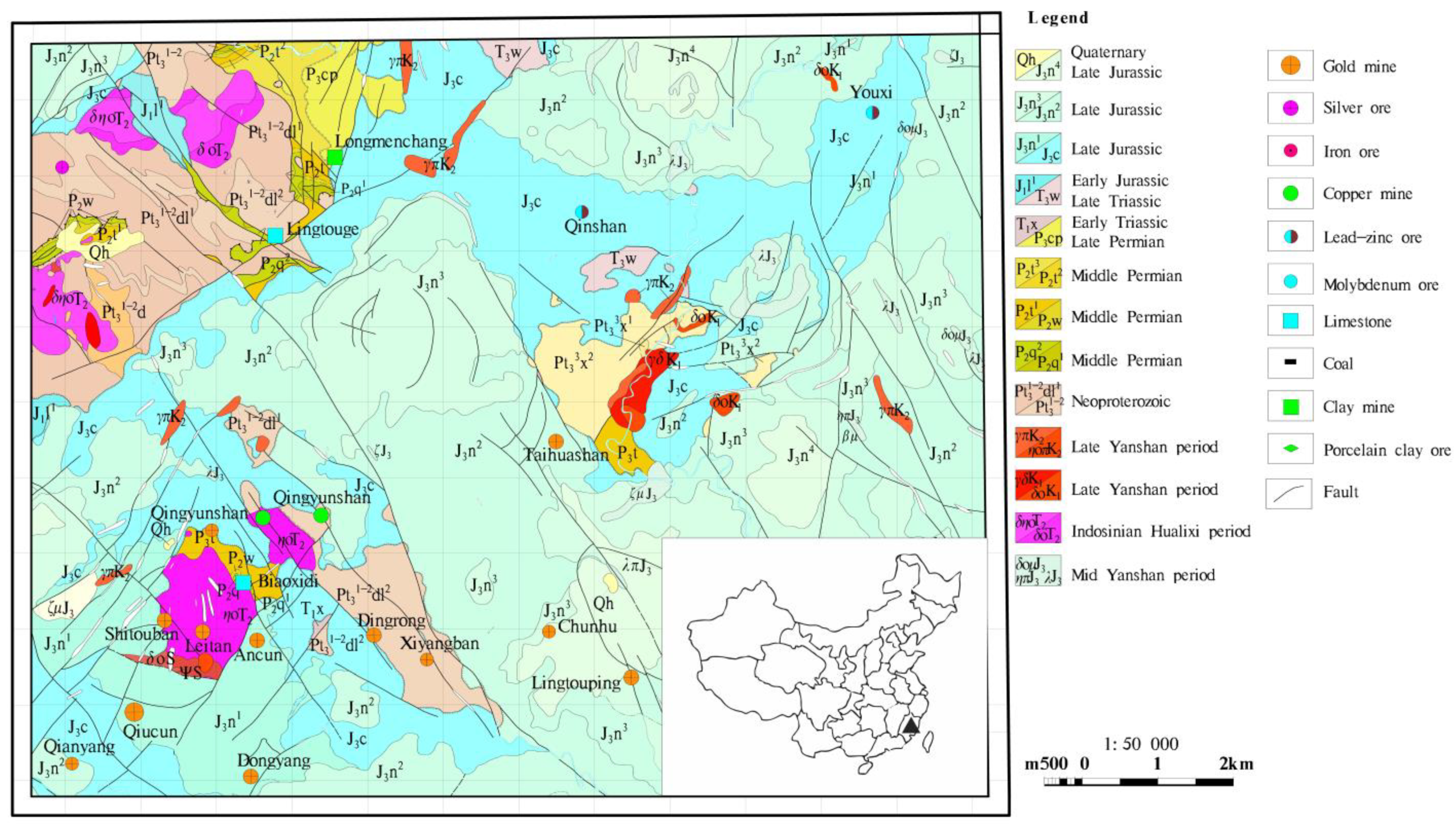
2. Geologic Setting
2.1. Stratigraphy
2.2. Structure
3. Methodology
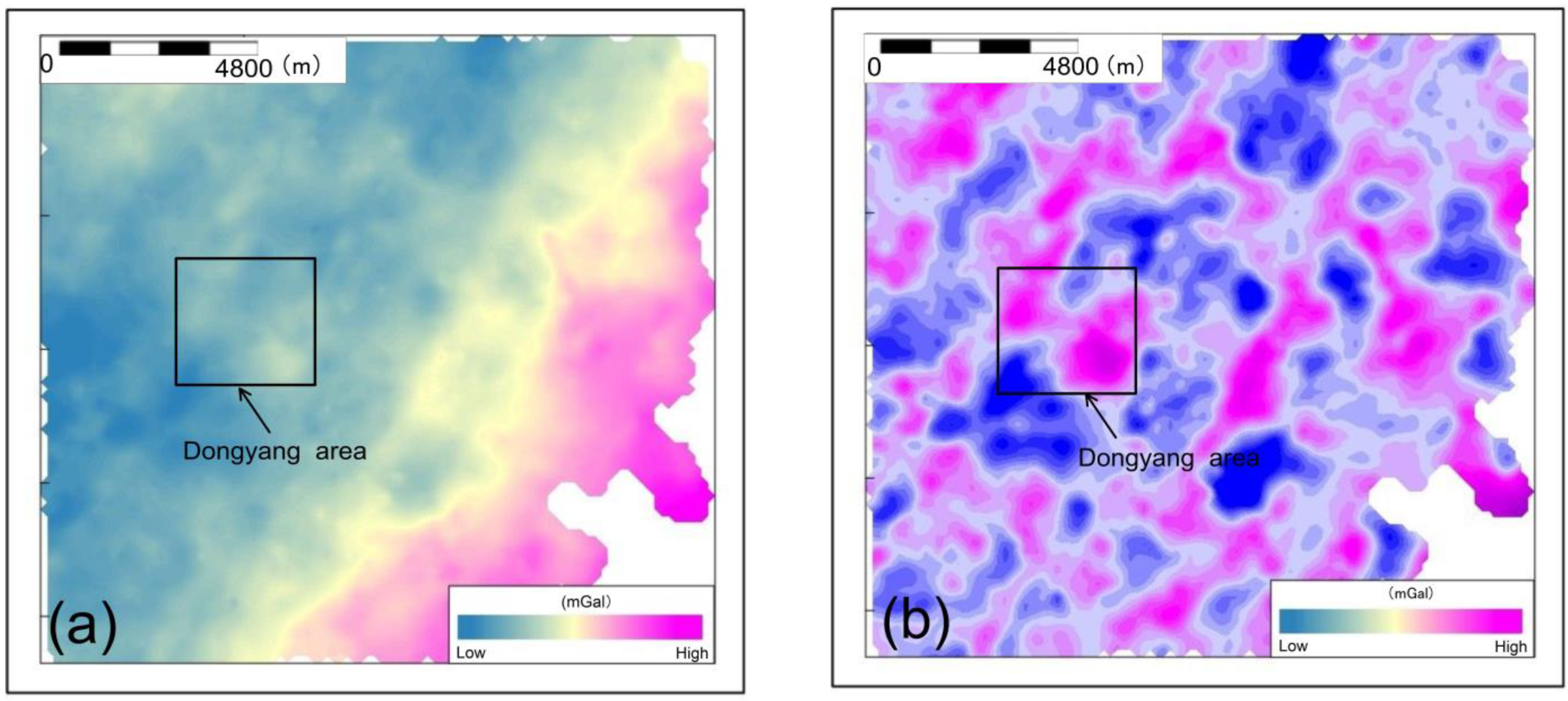
3.1. Regional Gravity
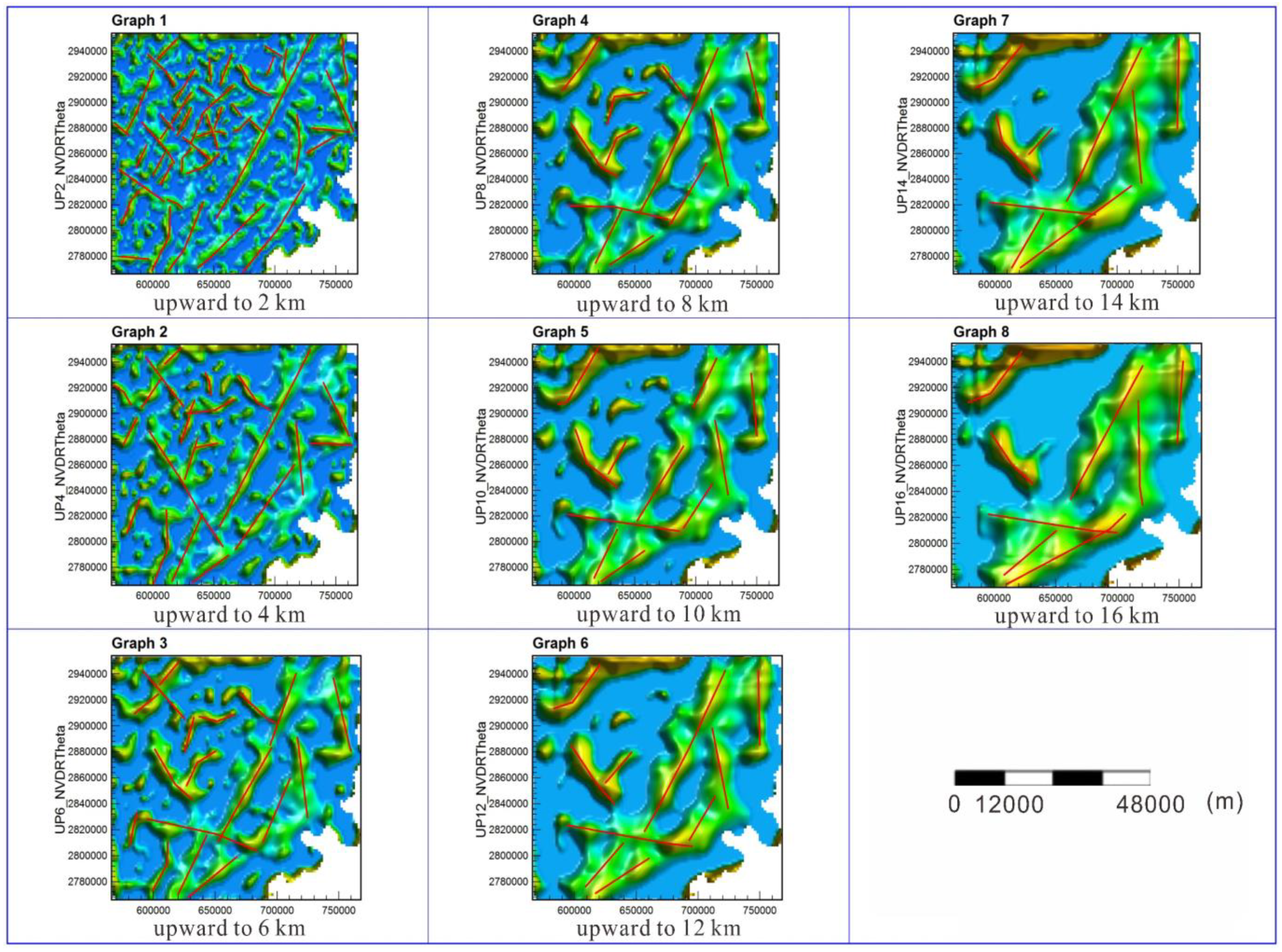
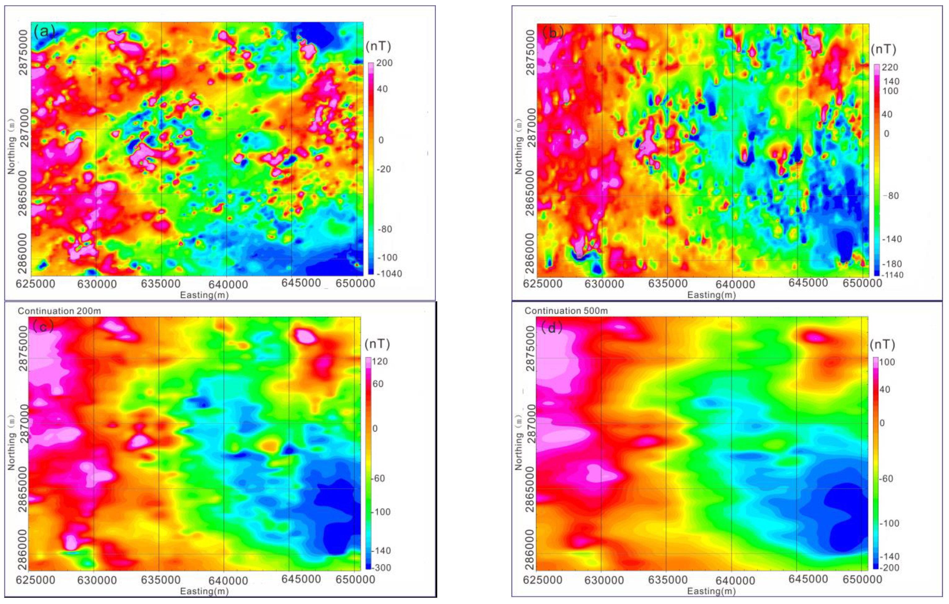
3.2. Regional Magnetic Field
4. Results and Discussion
4.1. Regional Gravity Field Analysis
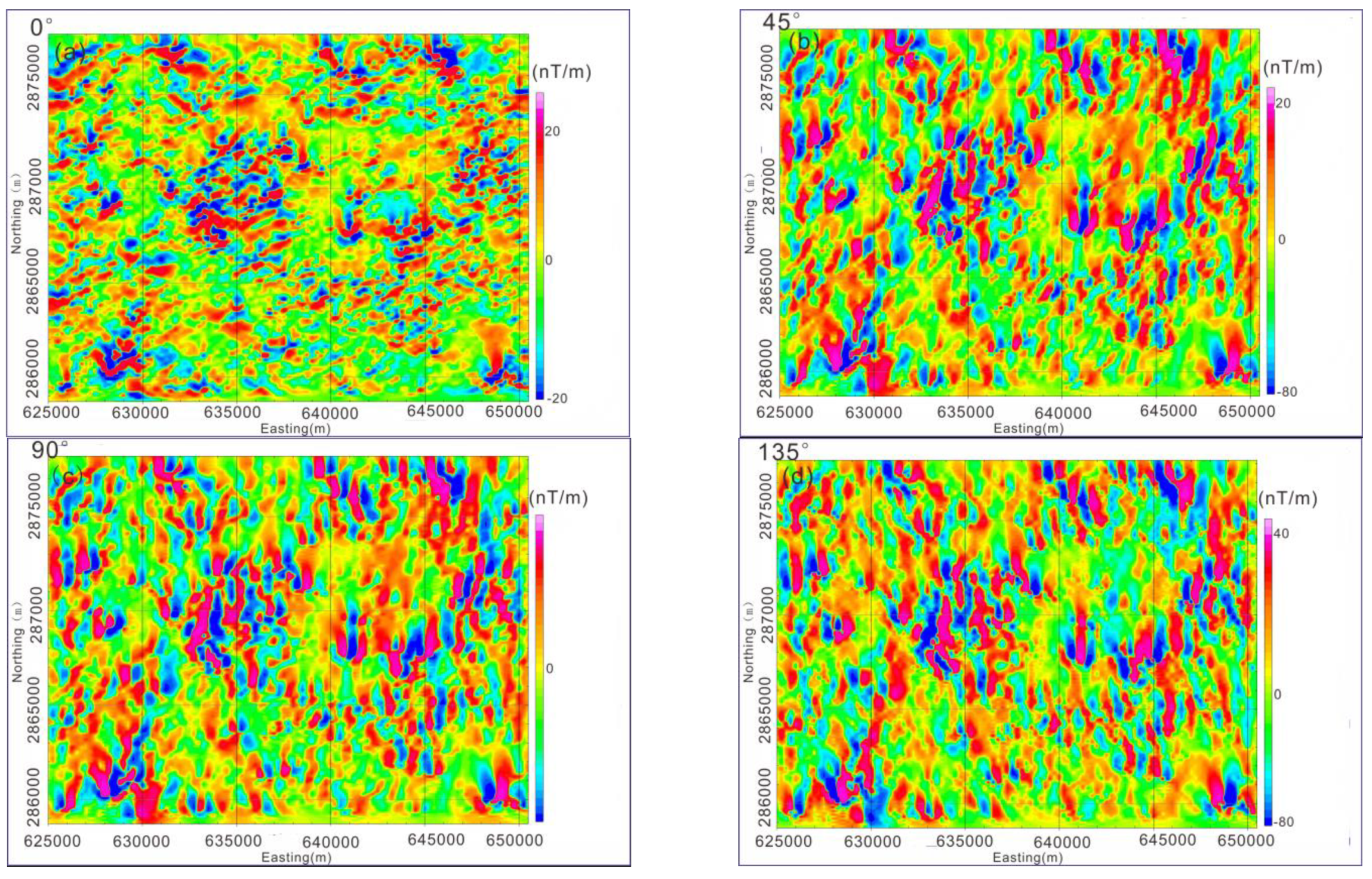
4.2. Regional Magnetic Field Analysis
- (1)
- Zone I: Longmen-Donghua-Yangmei
- (2)
- Zone II: Shangzhuang-Huashan-Chunhu-Gaiyang
- (3)
- Zone III: Jihua-Chiling
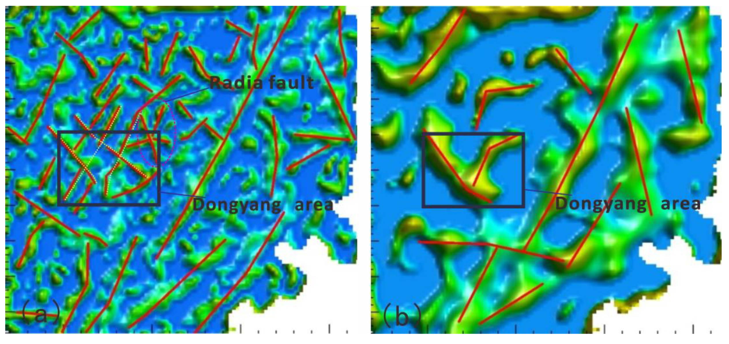
4.3. Interpretation of Fault Structures
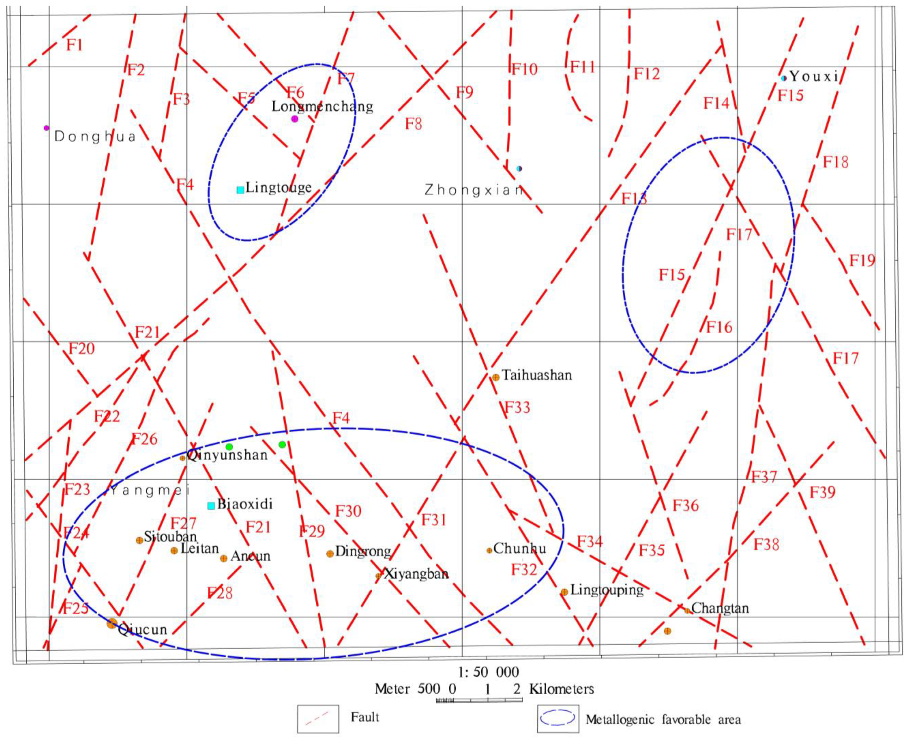
4.4. Prospective Mineral Exploration Area
- (1)
- Longmenchang Prospective Exploration Area
- (2)
- Qingyunshan-Qiucun-Chunhu Prospective Area
- (3)
- Youxijihua-Yongtai Zhufeng Prospective Area
5. Conclusions
Author Contributions
Funding
Data Availability Statement
Acknowledgments
Conflicts of Interest
References
- Zhdanov, M.S.; Wan, L.; Jorgensen, M. Joint Three-Dimensional Inversion of Gravity and Magnetic Data Collected in the Area of Victoria Mine, Nevada, Using the Gramian Constraints. Minerals 2024, 14, 292. [Google Scholar] [CrossRef]
- Meng, Q.F.; Ma, G.Q.; Li, L.L.; Wang, T.T.; Li, Z.R.; Wang, N.; Li, J.G. Joint Inversion of Gravity and Magnetic Data with Tetrahedral Unstructured Grid and its Application to Mineral Exploration. IEEE Trans. Geosci. Remote Sens. 2023, 61, 5915514. [Google Scholar] [CrossRef]
- Essa, K.S.; Abo-Ezz, E.R.; Anderson, N.L.; Gomma, O.A.; Elhussein, M. Magnetic inversion approach for modeling data acquired across faults: Various environmental cases studies. Acta Geophys. 2024, 72, 1819–1845. [Google Scholar] [CrossRef]
- Essa, K.S.; Mehanee, S.A.; Elhussein, M. Gravity data interpretation by a two-sided fault-like geologic structure using the global particle swarm technique. Phys. Earth Planet. Inter. 2021, 311, 106631. [Google Scholar] [CrossRef]
- Mehanee, S.; Essa, K.S.; Diab, Z.E. Magnetic data interpretation using a new R-parameter imaging method with application to mineral exploration. Nat. Resour. Res. 2021, 30, 77–95. [Google Scholar] [CrossRef]
- Essa, K.S.; Mehanee, S.; Elhussein, M. Magnetic Data Profiles Interpretation for Mineralized Buried Structures Identification Applying the Variance Analysis Method. Pure Appl. Geophys. 2021, 178, 973–993. [Google Scholar] [CrossRef]
- Prutkin, I.; Vajda, P.; Jahr, T.; Bleibinhaus, F.; Novák, P.; Tenzer, R. Interpretation of gravity and magnetic data with geological constraints for 3D structure of the Thuringian Basin, Germany. J. Appl. Geophys. 2017, 136, 35–41. [Google Scholar] [CrossRef]
- Wei, D.G.; Jie, Y.J. Characteristics of Regional Geological Structures in Fujian Province. Reg. Geol. China 1997, 16, 162–171. [Google Scholar]
- Yuan, H.X.; Chen, H.H. Progress in mineral exploration and characteristics of gold mineralization in Dehua area, Fujian. J. Mineral. 2015, 35, 1055. [Google Scholar]
- Li, G.K. The relationship between the basic framework of Fujian’s tectonic structure and the distribution of metallic minerals. Reg. Geol. China 1982, 1, 55–65. [Google Scholar]
- Xiang, H.L. The controlling factors and genesis of the Qiuchun gold deposit in Fujian. Gold Geol. 2002, 1, 40–43. [Google Scholar]
- Zhou, W.Y. Geological characteristics, ore-forming conditions, and ore-forming laws of gold deposits in the Youxi Dehua Yongtai area of central Fujian. Geol. Fujian 1996, 15, 199–208. [Google Scholar]
- Bao, S.Z. Discussion on the ore control conditions and prospecting direction of Fujian Yan Gold Mine. Fujian Geol. 2015, 34, 289–297. [Google Scholar]
- Mao, J.W.; Xie, G.Q.; Li, X.F.; Zhang, C.Q.; Mei, Y.W. Mesozoic large scale mineralization and multiple lithospheric extension in south China. Earth Sci. Front. 2004, 11, 46–56. [Google Scholar]
- Hua, R.M.; Chen, P.R.; Zhang, W.L.; Lu, J.J. Three major metallogenic events in Mesozoic in South China. Miner. Depos. 2005, 24, 99–107. [Google Scholar]
- Yue, L.Q.; Huang, C.P.; Zhang, K.Y. Discussion on the metallogenic epoch of gold deposits in Fujian province, southeast China. Geol. Prospect. 2002, 38, 17–21. [Google Scholar]
- Xu, N. A Study on the Metallogenic System and Genesis of Dongyang Gold Mine in Fujian Province. Ph.D. Thesis, China University of Geosciences, Beijing, China, 2017. [Google Scholar]
- Xu, Q.H.; Xie, W.Q.; Chen, Y.R. A Comprehensive Geochemical Anomaly Zoning Model and Exploration Prediction Indicators for Qiuchun Gold Mine in Fujian Province. Geol. Explor. 2005, 1, 56–61. [Google Scholar]
- Lei, F.Z. A Study on the Genesis of Shallow Hydrothermal Gold Deposits in Dongyang, Fujian Province. Ph.D. Thesis, Jilin University, Changchun, China, 2019. [Google Scholar]
- Huang, C.P. Research on the Metallogenic Characteristics and Prediction of Gold Deposits in Fujian Province. Ph.D. Thesis, China University of Geosciences, Beijing, China, 2017. [Google Scholar]
- Zhang, Z.; Hu, X.; Fang, H.; Wang, D. Study on Deep Geological Structure in Dongyang Area of Fujian Province, and Provide Theoretical Basis for Deep Prospecting Breakthrough. In AGU Fall Meeting; The SAO Astrophysics Data System: San Francisco, CA, USA, 2019. [Google Scholar]
- Li, G.K.; Liang, S.J. Regional geological characteristics of Fujian province. Geol. Bull. China 1987, 3, 201–210. [Google Scholar]
- Wang, J.F. Preliminary opinions on the geological structural characteristics of Fujian and the ore-forming relationship of magmatic activity. Jiangxi Build. Mater. 2016, 12, 236. [Google Scholar]
- Zhang, X.X. A Study on the Formation and Structural Deformation Evolution of the Neoproterozoic Mamianshan Group in the Central Fujian Region. Ph.D. Thesis, China University of Geosciences, Beijing, China, 2017. [Google Scholar]
- Chen, D.W. Geological characteristics of the Shuangqishan gold deposit in Fujian and analysis of its potential for prospecting in the surrounding areas of the mining area. Geol. Fujian 2012, 31, 1–11. [Google Scholar]
- Zhu, Y.L.; Liu, Y.F.; Zhang, J.T. Geological characteristics and genesis of Xiaban porphyry gold deposit in Dehua, Fujian. Geol. Fujian 2009, 28, 21–35. [Google Scholar]
- Lei, F.Z.; Sun, J.G.; Xu, Z.T.; Han, J.L.; Liu, Y. A Study on the Metallogenic Process and Genesis of the Dongyang Shallow Hydrothermal Gold Deposit in Dehua, Fujian Province. World Geol. 2019, 38, 339–353. [Google Scholar]
- Lin, Z.L. Geological characteristics and genesis of gold deposits in the Fufenglin mining area of Dehua, Fujian. Geol. Fujian 2019, 38, 208–215. [Google Scholar]
- Duan, G.; Chen, H.; Xu, C.; Qi, J. Metallogenic Model of Porphyry Shallow Temperature Superimposition in the Shandong South Oreblock of Zijin, Fujian Province. J. Mineral. 2015, 35, 12. [Google Scholar]
- Mao, G.W.; Tan, Y.S.; He, D.H.; Nie, D.P.; Liu, X.D. Exploration of mineralization types and prospecting directions in the Jinban ore section of the Taihua Mountain gold deposit in central Fujian. Depos. Geol. 2017, 36, 736–748. [Google Scholar]
- Wang, X.Z. Geological characteristics and ore-forming prediction of the Xiaoban East Belt gold deposit in Youxi, Fujian. Energy Environ. 2016, 2, 112–113. [Google Scholar]
- Ren, Z.Y.; Liu, J.X.; Yue, G.X.; Zhang, Y.L. Research progress of gravity and magnetic methods in the exploration of non-ferrous metal minerals. Chin. J. Nonferrous Met. 2023, 33, 240–260. [Google Scholar]
- Liu, H.L.; Chen, C.D.; Fan, J.J.; Zhang, X.; Peng, W.X.; Zhang, W. Fault structure identification based on gravity data and its application in the Wuwei area. World Geol. 2023, 42, 334–342. [Google Scholar]
- Wijns, C.; Perez, C.; Kowalczyk, P. Theta map: Edge detection in magnetic data. Geophysics 2005, 70, L39–L43. [Google Scholar] [CrossRef]
- Shen, H.Y. Research on Computer Automatic Identification and Zoning Technology for Regional Magnetic Anomaly. Master’s Thesis, China University of Geosciences, Beijing, China, 2019. [Google Scholar]
- Yang, J.; Wang, Q.; Guo, J.; Zeng, Q.Q. Wavelet modulus maximum decomposition of gravity and magnetic anomalies and its application in Beiya mining area. Geophys. Geochem. Explor. Calc. Technol. 2019, 41, 485–494. [Google Scholar]
- Wei, M.J. Determination of Normal Field Values in Magnetic Exploration. China Sci. Technol. Inf. 2012, 23, 35–40. [Google Scholar]
- Guo, L.H.; Meng, X.H.; Shi, L.; Chen, Z.X. Optimized Filtering Method and Its Application to Bouguer Gravity Anomaly Data Processing in Chinese Mainland. J. Geophys. 2012, 55, 4078–4088. [Google Scholar]
- Yao, C.L.; Li, H.W.; Zheng, Y.M.; Meng, X.H.; Zhang, Y.W. Comprehensive Analysis and Research on Iterative Method in Calculation of Gravity and Magnetic Potential Field Conversion. J. Geophys. 2012, 55, 2062–2078. [Google Scholar]
- Zhang, F.X. Research on High-Precision Gravity Anomaly Data Processing Methods and Technologies. Ph.D. Thesis, Jilin University, Changchun, China, 2006. [Google Scholar]
- Li, L.; Wu, Y.G.; Yang, C.B.; Huan, H.F.; Guo, C.C. Several boundary identification methods of gravity data and application in Vientiane of Laos area. Glob. Geol. 2014, 17, 55–61. [Google Scholar]
- Gordon, G.R.J.; Duncan, D.R. Edge enhancement of potential-field data using normalized statistics. Geophysics 2008, 71, H1–H4. [Google Scholar]
- Xu, S.Z. Integral Iterative Method for Potential Field Extension. J. Geophys. 2006, 4, 1176–1182. [Google Scholar]
- Zhang, Z.H.; Wu, L.Y. The correlation coefficient method for downward extension of potential field. J. Jilin Univ. (Earth Sci. Ed.) 2012, 42, 1912–1919. [Google Scholar]
- Gao, Y.W.; Luo, Y.; Wen, W. Research and application of compensation downward extension method. J. Geophys. 2012, 55, 2747–2756. [Google Scholar]
- Jia, Z.; Li, Y.S.; Wang, Y.H.; Li, Y.; Jin, S.B.; Li, Y.X.; Lu, W.K. Deep Learning for 3-D Magnetic Inversion. IEEE Trans. Geosci. Remote Sens. 2023, 61, 5905410. [Google Scholar] [CrossRef]
- Utsugi, M. 3-D inversion of magnetic data based on the L1–L2 norm regularization. Earth Planets Space 2019, 71, 73. [Google Scholar] [CrossRef]
- Li, Y.; Oldenburg, D.W. 3-D inversion of magnetic data. Geophysics 1996, 61, 394–408. [Google Scholar] [CrossRef]
- Wang, W.Y.; Qiu, Z.Y.; Yang, Y.; Shi, W.J. Research progress in edge recognition methods for potential fields. Prog. Geophys. 2010, 25, 196–210. [Google Scholar]
- Ma, L.; Meng, J.H.; Shan, Z.X.; Li, X.L.; Li, F.Y.; Jin, Y.M.; Wang, J.H.; Li, B.L. Comparison and application research on new methods for identifying the boundaries of gravity and magnetic anomaly sources. Prog. Geophys. 2017, 32, 2514–2519. [Google Scholar]


Disclaimer/Publisher’s Note: The statements, opinions and data contained in all publications are solely those of the individual author(s) and contributor(s) and not of MDPI and/or the editor(s). MDPI and/or the editor(s) disclaim responsibility for any injury to people or property resulting from any ideas, methods, instructions or products referred to in the content. |
© 2024 by the authors. Licensee MDPI, Basel, Switzerland. This article is an open access article distributed under the terms and conditions of the Creative Commons Attribution (CC BY) license (https://creativecommons.org/licenses/by/4.0/).
Share and Cite
Zhang, Z.; Li, Y.; Chen, L.; Zhang, Q.; Sun, Y. Deep Geological Structure Analysis of the Dongyang Area, Fujian, China: Insights from Integrated Gravity and Magnetic Data. Minerals 2024, 14, 837. https://doi.org/10.3390/min14080837
Zhang Z, Li Y, Chen L, Zhang Q, Sun Y. Deep Geological Structure Analysis of the Dongyang Area, Fujian, China: Insights from Integrated Gravity and Magnetic Data. Minerals. 2024; 14(8):837. https://doi.org/10.3390/min14080837
Chicago/Turabian StyleZhang, Zhenyu, Yongbo Li, Liang Chen, Qiang Zhang, and Yue Sun. 2024. "Deep Geological Structure Analysis of the Dongyang Area, Fujian, China: Insights from Integrated Gravity and Magnetic Data" Minerals 14, no. 8: 837. https://doi.org/10.3390/min14080837
APA StyleZhang, Z., Li, Y., Chen, L., Zhang, Q., & Sun, Y. (2024). Deep Geological Structure Analysis of the Dongyang Area, Fujian, China: Insights from Integrated Gravity and Magnetic Data. Minerals, 14(8), 837. https://doi.org/10.3390/min14080837