Article

Spatial and Temporal Distribution of Igneous Sills in the Central Tarim Basin and Their Geological Implications

1
College of Civil Engineering, Zhejiang University of Technology, Hangzhou 310026, China
2
Department of Marine Sciences, Zhejiang University, Zhoushan 316021, China
Minerals 2024, 14(9), 862; https://doi.org/10.3390/min14090862
Submission received: 24 July 2024 / Revised: 21 August 2024 / Accepted: 23 August 2024 / Published: 24 August 2024

Abstract

:
Interpretation of the seismic reflection profiles associated with borehole data from the petroleum industry offers a novel way to study sill emplacement in sedimentary basins. This study uses this approach to reveal the intrusive part of the Tarim Large Igneous Province (LIP) within the basin, which has not been systematically reported. A large number of igneous intrusions (sills) are identified in the sedimentary layers of the Central Tarim Basin. The burial depth of the sills is 6–8 km, and they are mainly located within the upper Ordovician strata. According to their seismic facies and drilling data, it is inferred that they are dolerite sills. Based on the uplift of the overlying strata above the intrusions, it is concluded that the sills were mainly formed during the depositional period of the middle Permian Kupukuziman Formation and Kaipailezike Formation (early stage), with a few formed during the depositional period of the upper Permian strata (late stage). It is likely that these two stages of sill intrusion correspond to the main basaltic eruptions within the basin and the mafic dike emplacement in the Bachu area of the Tarim LIP, respectively. The study suggests that that the dolerite sills reported in this study are also an important component of the Permian Tarim LIP.

1. Introduction

Magma storage, transport and eruption are important geological processes within the Earth’s crust which originate igneous structures such as sheet and tabular intrusions (e.g., dykes, sills and laccoliths) and extrusive lava flows on the surface [1,2,3]. The igneous extrusions and intrusions have traditionally been studied through geological field investigations, which limits our understandings about the geometry and dynamics of the magma transport [4,5]. Over the last few decades, based on the seismic reflection and borehole data from the petroleum industry, numerous igneous intrusions have been revealed in sedimentary basins worldwide [6,7,8,9,10]. Significant progress has been made on the geometry, distribution and transport dynamics of sill intrusions, as well as the associated host rock deformation [11,12,13,14]. Moreover, igneous intrusions can affect the thermal state of the surrounding sedimentary host rocks. When sills are emplaced in organic-rich sedimentary formations, they can considerably affect the maturation history of the hydrocarbon source rocks and greenhouse gases such as (methane) CH4 and (carbon dioxide) CO2 can form [15,16]. If the intrusive complexes are voluminous, such as in the Neuquén Basin in Argentina [12,16], the Vøring and Møre basins in offshore mid-Norway [6,17] and the Karoo Basin in South Africa [18,19,20], the thermal effects can be basin scale, the petroleum system can be strongly influenced and thousands of gigatons of greenhouse gases can be generated.
The Tarim Basin is a large oil-bearing basin lying in the northwestern part of China (Figure 1). The largest igneous activity in the Tarim Basin is known as the Tarim Permian LIP. The first study related to the Permian LIP dates back to 1991 [21], but its existence has been further recognized and confirmed by more recent geochemical and geochronological studies [22,23,24,25,26,27].
However, the current research mostly focuses on the extrusive part of the Tarim Permian LIP, whereas the intrusive components such as diabase or gabbro bodies within the basin are largely unknown [28]. In particular, there is a scarcity of knowledge regarding their geometry and spatial distribution, mainly because of the deep emplacement of the intrusive bodies within the basin. The target reservoir in the basin is used to be the sandstone of the Donghetang Formation of the upper Devonian strata, whereas the sills were emplaced within the Silurian and Ordovician units. Therefore, most wells have not encountered these bodies, making traditional methods such as field observation, well logging identification and drilling sampling ineffective.
Note that igneous intrusions can be well imaged in seismic reflection data when they are emplaced within sedimentary layers, as they have a relatively high acoustic impedance [6,29]. Some scholars have also used seismic profiles to study the Permian igneous intrusions in the Central Tarim Basin [30,31,32]. However, better knowledge regarding the geometry and distribution of the Permian intrusions is still needed. To this purpose, this paper utilizes extensive 2D seismic profiles, some 3D seismic data and well data from the Katake Uplift (also named as the Tazhong low uplift) and adjacent areas (Figure 1). This study revealed the presence of numerous igneous intrusions in the central part of the Tarim Basin. Because magmatic intrusions have a significant thermal effect, they also influence the paleotemperature field of the Tarim Basin, implying that studying the magmatic intrusion processes is also of great importance for oil and gas exploration within the basin.

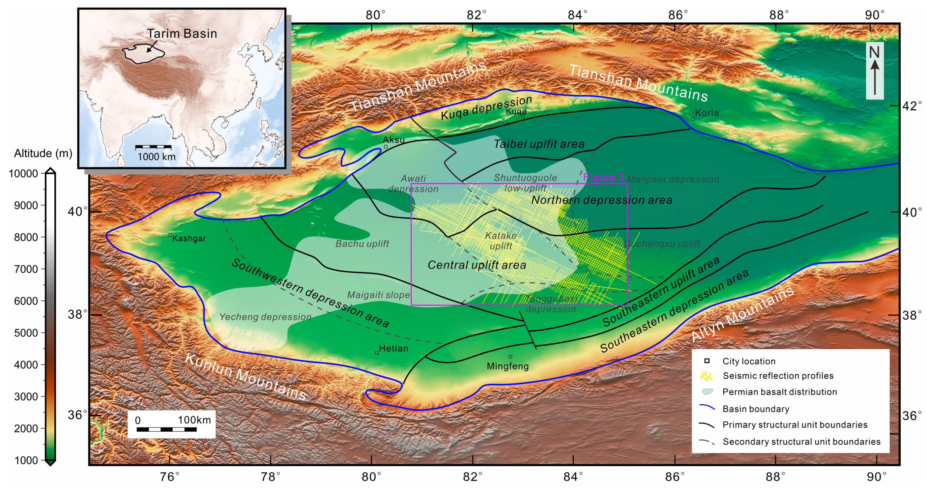
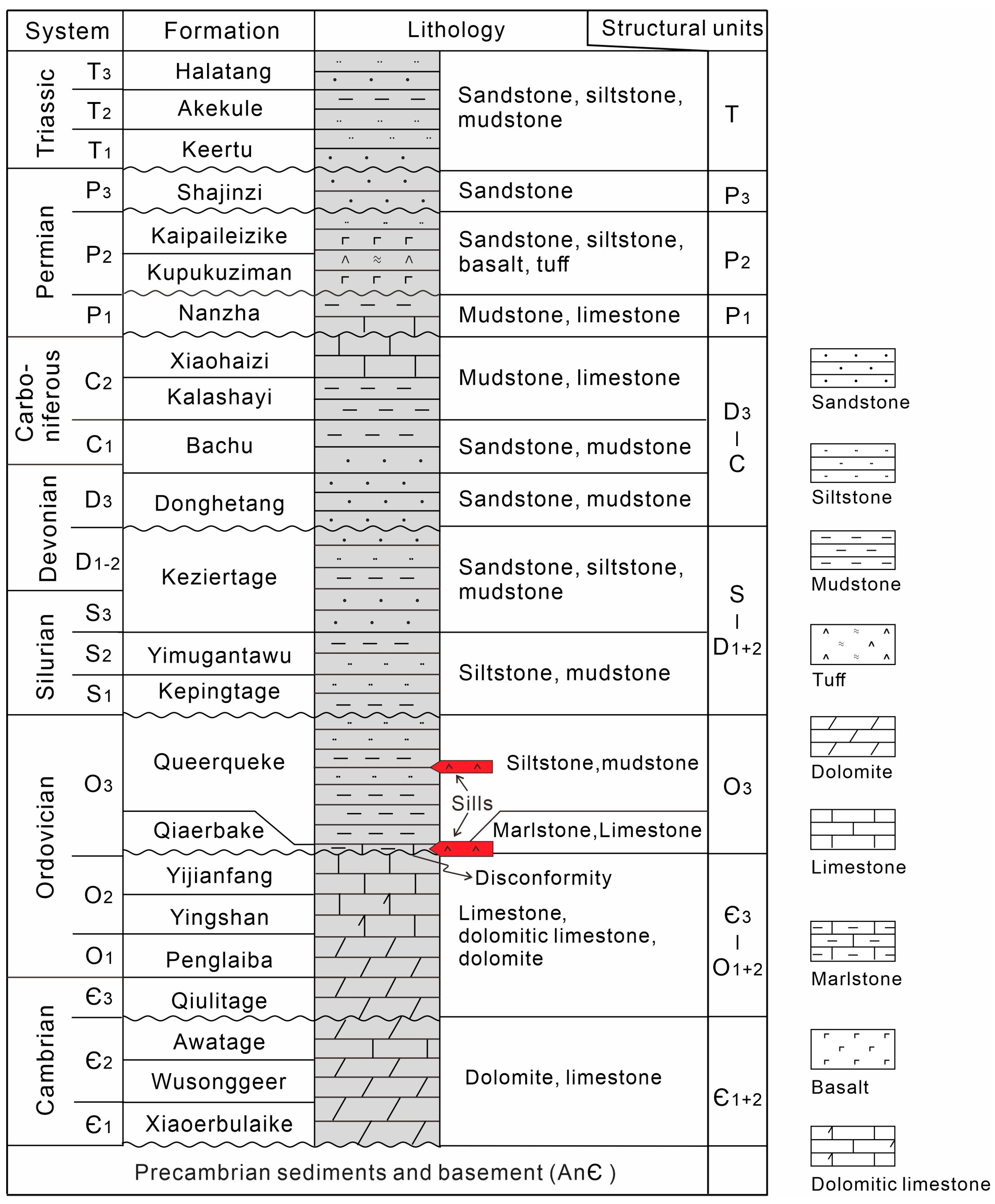
2. Geological Setting

The Tarim Basin, located in southern Xinjiang, China, stretches 1500 km from east to west and approximately 600 km from north to south, covering an area of 560,000 km2 [33]. It is the largest inland basin in China and has hydrocarbon reserves of more than 1010 t [34]. Most of the basin is now covered by shifting sands known as the Taklamakan Desert, thus the sedimentary layers and igneous intrusions can only be observed at the margin of the basin. The Tarim Basin is a large, complex superimposed basin that developed on the Precambrian continental crust and has undergone multiple phases of geological evolution [35]. The formation of the Tarim Basin was characterized by regional extension associated with the breakup of the Rodinia supercontinent and the development of surrounding oceans [36,37]. After the initial growth, the basin generally experienced a cratonic evolution stage from the Cambrian to Permian and converted to a foreland basin from the Triassic to Cretaceous [33]. Note that during the Jurassic, most of the Tarim Basin was uplifted and the Jurassic strata were deposited only in the northwestern part of the basin. Since the Cenozoic, the evolution of the Tarim Basin has been mainly affected by far-field compression controlled by collision between the Indian plate and Eurasian plate [38]. At this stage, the Tarim Basin was characterized by a rejuvenated foreland basin [39].
Igneous activities within the Tarim Basin are known for the Permian LIP, as mentioned in the previous section. The flood basalts are emplaced within the Kupukuziman and Kaipaileizike formations of the middle Permian (Figure 2). It is constrained by drilling data that the Permian basalts in the Tarim Basin cover an area of nearly 200,000 km2, with multiple residual thickness centers and a cumulative maximum thickness exceeding 500 m [22,30]. The basalts are exposed at the periphery of the basin, including the Keping area at the northwest edge of the basin and the southwestern edge of the Tarim Basin [40,41]. The most complete exposures of the Permian basalts are in the Keping area. The Kupukuziman formation contains two layers of basalt with a cumulative thickness of 10–75 m, while the Kaipaileizike formation consists of six layers with a cumulative thickness up to 420 m [22].
The study area is located in the central part of the Tarim Basin, involving structural units such as the Katake uplift, Awati depression, Shuntuoguole low-uplift, Guchengxu uplift and Tangubasi depression (Figure 1 and Figure 3). The study area contains strata from the Cambrian to Quaternary. However, the Jurassic strata are missing in the study area due to the uplift of the central and southwestern part of the Tarim Basin during the Jurassic. Since the Cambrian, the study area has been influenced by Caledonian and Hercynian tectonic movements, forming major unconformities at the base of the upper Ordovician, Silurian, upper Devonian, Lower Permian sand-mudstone layers, middle Permian igneous rock layers, upper Permian sand-mudstone layers and the base of the Triassic (Figure 2).

3. Data and Methods

The intrusions developed within sedimentary layers, especially dolerites, have a higher density and acoustic impedance than the surrounding rocks. Therefore, they tend to form continuous, high-amplitude reflections in seismic profiles. These strong reflections often develop along bedding planes or cut across the surrounding sedimentary layer reflections, forming specific spatial shapes such as “saucer-shaped” [6,42,43,44]. Therefore, in this work I use the seismic profiles to study the geometry and distribution of the igneous sills based on the seismic reflection facies.
The data used in this study are predominantly two-dimensional seismic reflection profiles that cover the Katake uplift and adjacent areas (Figure 1). The spacing between the seismic profiles varies from 2 km to 10 km, permitting a quasi-three-dimensional imaging of igneous sills. Moreover, some three-dimensional (3D) seismic profiles are also used as they have relatively higher vertical resolutions. The frequency of the 3D seismic profiles in the study area is approximately 27–30 Hz, while the 2D seismic profiles have a frequency of around 20–24 Hz. The velocity of the diabase encountered in the Silurian of Tazhong 22 is 6032 m/s [45], and the widely adopted approximate velocity for shallow intrusions (1–2 km) of igneous rocks in a series of North Atlantic basins is 5550 m/s [6]. Therefore, this study assumes an approximate velocity of 6000 m/s for the deeply emplaced (3–3.5 km) magmatic intrusions in the study area. According to calculations, the minimum thickness of an intrusive rock that can produce anomalous reflections in the 3D seismic profile (λ/10) is 20–22 m, and in the 2D seismic profile it is 25–30 m. As shown in Figure 4, when an intrusive body in the seismic profile presents a weak–strong–weak high-amplitude reflection pattern similar to a Ricker wavelet, it indicates a thickness between λ/10 and λ/4, which translates to 20–55 m in the 3D seismic profile and 25–75 m in the 2D seismic profile. This value also aligns with the results from drilling (Adong1 well).

4. Results

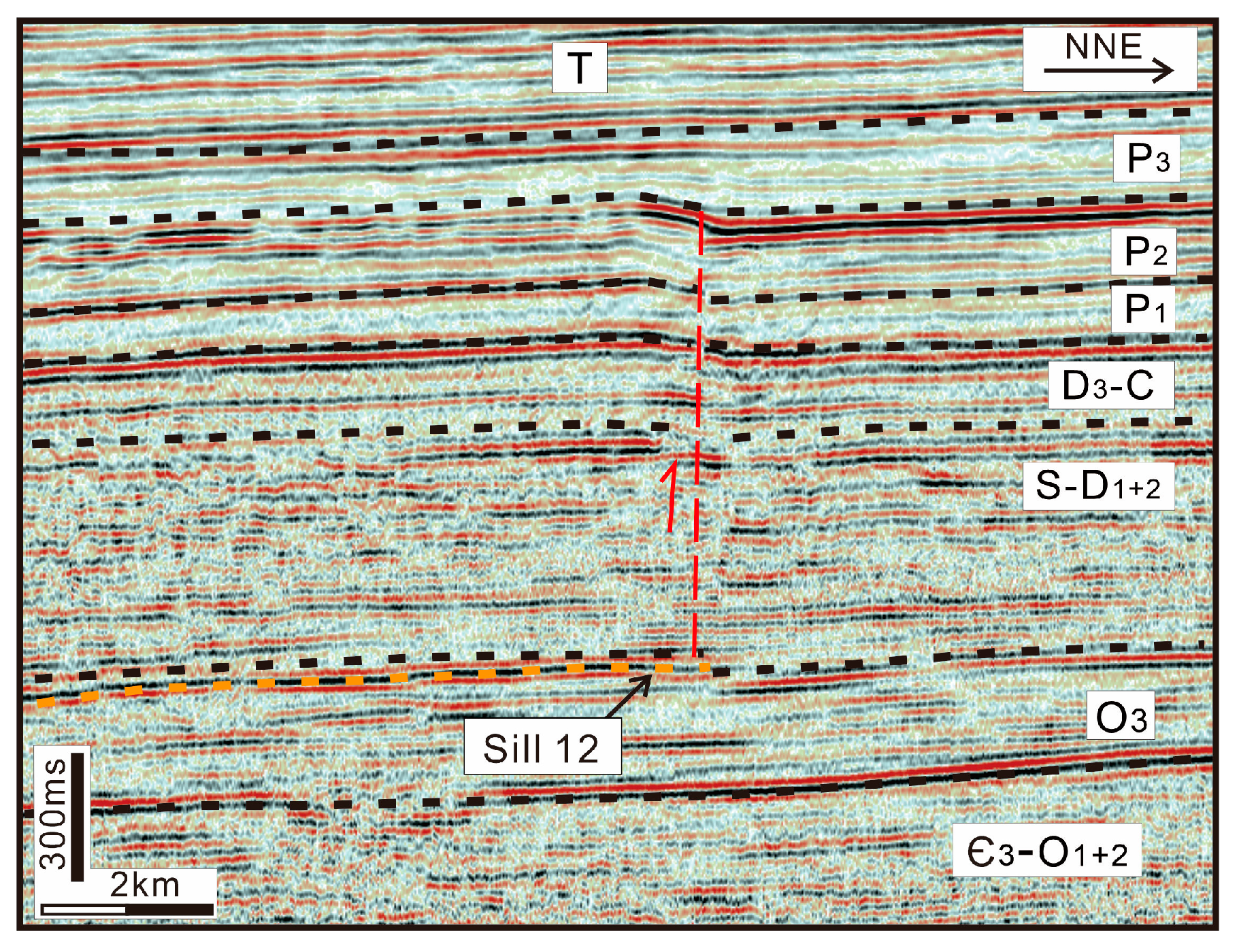
4.1. Seismic and Borehole Recognition of Igneous Sills

Igneous sills can be confidently recognized from the seismic profiles. As shown in Figure 4 and Figure 5, continuous, high-amplitude reflections can be observed in the seismic profiles. They also cut across sedimentary layers and exhibit specific geometric shapes. High-resolution 3D seismic profiles also show some offset in the sedimentary layer reflections across the continuous strong reflection axes, indicating that these anomalous reflectors formed after sedimentation. Moreover, 3D seismic imaging can better delineate intrusive bodies than 2D seismic data (Figure 4). Based on these characteristics, I infer that similar seismic anomalous reflectors are magmatic intrusions and classify them as sills based on their morphology.
Figure 4. Typical seismic reflections of one igneous sill (Sill 2) in the study area. (a,b) are a 3D seismic profile and a 2D seismic profile, respectively (for location see Figure 3). The black box in (a) and yellow box in (b) represent the nearby location of Sill 2. S-D1+2, O3 and Є-O1+2 are strata symbols. See Figure 2 for detail.
Minerals 14 00862 g004
Figure 5. A seismic profile of sill 13 (after [13]) (for location see Figure 3). TWT: two-way travel time. T, P3, P2, etc., are strata symbols. See Figure 2 for detail.
Minerals 14 00862 g005
In the study area, the wells Adong1 and Shun2 (locations shown in Figure 3) also encountered deep intrusive bodies. In the Adong1 well, two sets of dolerite sills with a total thickness of approximately 100 m were encountered within the upper Ordovician strata. According to well-to-seismic calibration, these sills correspond to the strong amplitude reflections cutting through sedimentary layers in the seismic profiles (Figure 5). Microscopic photos from the intrusive rocks in the Adong1 well show that both samples, taken approximately 2 m apart vertically from the same rock body, exhibit a clear dolerite texture. Figure 6a shows that the rock is composed of 76% tabular plagioclase, 20% short-columnar pyroxene, 2% alkali feldspar and 2% iron minerals, with visible biotite. Figure 6b also displays a diabasic texture, comprising 77% tabular plagioclase, 20% short-columnar pyroxene, 3% iron minerals and minor biotite, suggesting that both are typical diabases. Thus, it can be further inferred that the intrusive sills are dolerites, consistent with similar studies worldwide [6,7].

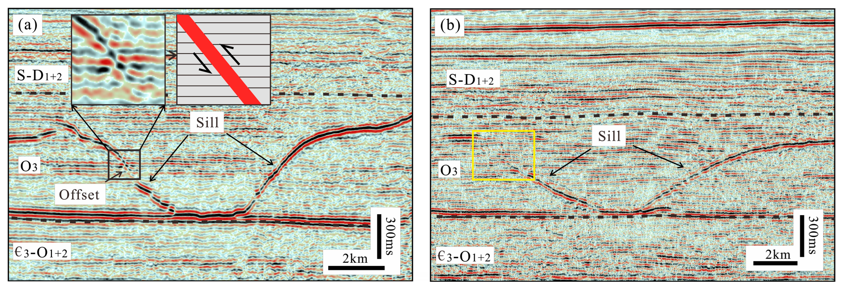
4.2. Distribution of Igneous Sill

Based on the identification from seismic profiles, nineteen intrusive bodies were identified in the study area (Figure 3). In vertical view, these sills are typically emplaced within the upper Ordovician strata, with a current burial depth of about 6–8 km. Horizontally, the intrusions are mainly developed in the northern part of the study area, i.e., the Awati depression and the western section of the Shuntuoguole low uplift, with a few distributed in the southern part of the study area, i.e., the central-northern part of the Tangubasi depression (Figure 3). These bodies cover an area of approximately 9115 km2 and, due to the overlap of bodies above and below, their actual area is about 10,628 km2 (Table 1). It is worth noting that there are limitations in the resolution of seismic profiles for intrusive bodies and some bodies did not image in the seismic profiles. Therefore, the actual range of magmatic intrusion in the study area should be much larger than revealed in this study.

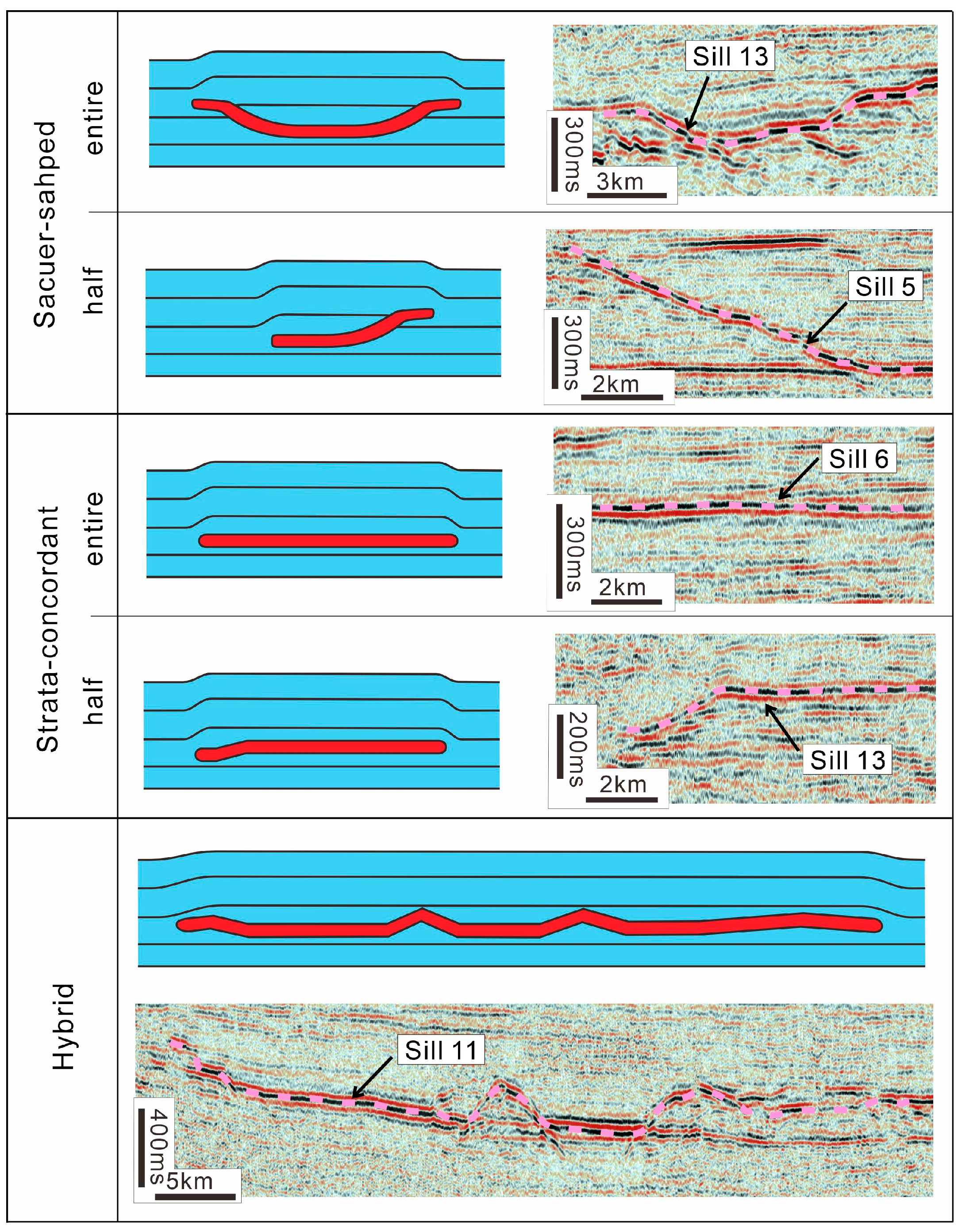
4.3. Geometry of Igneous Sills

Based on the classification and naming of the magmatic intrusions within the basins of previous studies [4,6,8], we categorize the morphology of intrusive sills in the study area into three main types: saucer-shaped sills, strata-concordant sills, and hybrid sills (half and entire Figure 7).
Saucer-shaped sills refer to intrusions characterized by a flat inner sill and inclined sheets on either side and possibly a flat outer sill [5]. Eight saucer-shaped sills have been identified in the study area, making it the most commonly developed type of sill in this region. Among these, five sills are not fully developed. Therefore, this type of sill can be divided into complete saucer-shaped sills and half saucer-shaped sills. As shown in Figure 7, sill 13 is a typical saucer-shaped sill.
Strata-concordant sills are intrusions that are overall concordant or slightly unconcordant to the sedimentary layers and are also widely distributed in the study area. Six strata-concordant sills have been identified in the study area, with one sill showing partial transition to a saucer-shaped sill and thus being defined as a half strata-concordant sill. Strata-concordant sills have relatively smaller planar areas, averaging 267.3 km2.
Hybrid sills refer to sills with complex spatial shapes. These sills may be composed of multiple saucer-shaped sills or strata-concordant ones. A total of five hybrid sills have been discovered in the study area. The hybrid sills have a large plane area. The average area reaches 1242.4 km2, which greatly exceeds the area of the other two types.

5. Discussion

5.1. Uplifting of the Overburden and Dating the Sill Emplacement

Sill emplacement within sedimentary layers can uplift the overlying strata. In some cases, syn-uplifting faults can be formed near the surface. Peripheral faults can also develop at the edges of the uplift. The formation time of this uplift and the associated faults corresponds to the time of magma intrusion [42,46,47] (Figure 8). Therefore, in seismic profiles, the relative timing of magma intrusion can be identified based on the formation of these uplifts. This method has been successfully applied in various basins worldwide [6,7,8,9,10].
As shown in Figure 5 and Figure 9, the uplift of strata bounded by steep faults is present in the layers above the sill. The uplifted area spatially corresponds to the extent of the sill, indicating that the uplift was caused by magma intrusion. The seismic profile shows that faults developed at the tip of the sill, crosscutting the upper Ordovician and Silurian-middle Devonian strata. The displacement transitions in the lower part turn to folding in the upper strata. Therefore, the deformation within the upper Devonian-Carboniferous to the Lower Permian strata is characterized by folding. The fold deformation gradually disappears in the middle Permian strata, indicating that the uplift of strata above the sill and the development of reverse faults mainly occurred during the deposition of the middle Permian. Similarly, some uplifts formed during the upper Permian deposition have been observed (Figure 9). Therefore, it can be inferred that the magma intrusions in the study area mainly developed during the middle Permian deposition period, with a few during the upper Permian deposition period. This result is roughly consistent with the age obtained from the 40Ar-39Ar dating method for the diabase in the Lianglitage Formation of the upper Ordovician from the well Shun2, which is between 274.6 and 276.3 Ma [48].

5.2. Controls on the Sill Geometry

In addition to the predominant saucer-shaped intrusions, the intrusions within the sedimentary layers in the central uplift also exhibit strata-concordant and hybrid morphologies. Further analysis reveals that strata-concordant sills typically develop above the inclined sheets of saucer-shaped sills. The formation process of saucer-shaped sills involves the extension of a flat inner sill, forming inclined outer sills and eventually creating flat outer sills (Figure 8). Therefore, based on the spatial position and morphology of strata-concordant sills, it is inferred that their shape is likely the result of the fully developed outer beds of saucer-shaped sills. Additionally, the hybrid sills are composed of the different morphological features of saucer-shaped and strata-concordant sills.
It can be further inferred that the morphological characteristics of sills in the study area can be explained by the evolutionary model of saucer-shaped sills. It suggests that saucer-shaped sills represent the basic morphology of magmatic intrusions in the study area. This observation is consistent with phenomena observed in other basins worldwide [6,8,44].
Additionally, it is noteworthy that the base of the saucer-shaped sills in the study area generally coincides with the base of the upper Ordovician. This indicates that this unconformity surface, serving as the interface for magma intrusion, significantly controls the depth and morphology of the intrusive bodies. Recent physical simulation experiments have shown that the magma intruding through layers tends to follow a near-horizontal unconformity when encountered [47,49,50,51].
Moreover, numerical simulations have shown that magma also exhibits selectivity whether to use an unconformity as a propagation pathway, indicating that it is related to the lithology above and below the unconformity [52]. In the study area, the middle Ordovician strata is primarily composed of limestone, while the upper Ordovician is mainly composed of mudstone. This combination of lithologies above and below the boundary controlled the propagation of ascending magma.

5.3. Lithology of the Sills

The lithology of sills can be inferred based on the seismic facies and morphological characteristics combined with drilling data. In the central part of the Tarim Basin, the sills show continuous, high-amplitude reflections on seismic profiles, predominantly in a saucer shape. Studies in the northern East China Sea Shelf Basin and the Vøring and Møre basins have found that similar saucer-shaped sills are mainly composed of dolerite [6,7]. In this study area, wells such as Tazhong33, Shun2, Tazhong 9 and Adong1 have encountered intrusive rocks in the upper Ordovician strata, which indicate that the lithology of these intrusions is mainly dolerite [13,45]. Therefore, it is inferred that the intrusive bodies in the study area are primarily composed of dolerite.

5.4. Timing of Sill Emplacement

Previous studies indicate that the basaltic eruptions and intrusions of the Tarim (LIP) can be divided into two main phases. The first phase includes the basalts of the Kupukuziman and Kaipaileizike formations, which are exposed in the Keping area and widely distributed within the basin [22,24]. These basalts, interlayered with sandstone and mudstone, suggest that the basaltic eruptions and sediment deposition occurred synchronously. Recent zircon U-Pb dating further indicates that the Kupukuziman basalts date to approximately 289.77 Ma, while the basalts within the Kaipaileizike formation date to about 284.27 Ma [41]. Both of them are in the early Permian time, with a time difference of 5.5 Ma. This period is the concentrated phase of basaltic eruptions in the Tarim Basin during the Permian [25,41].
The second phase is characterized by the mafic dykes in the Bachu area, dated to around 280 Ma, which is also in the early Permian [53]. However, the geochemical characteristics of these diabase bodies differ significantly from the basalts in the Keping area. It indicates a smaller-scale mafic magma intrusion event following the main eruption period [25].
The study reveals that the dolerite sills in the Central Tarim Basin primarily occurred during the deposition periods of the Kupukuziman and Kaipaileizike formations in the Permian, with some forming during the deposition of the upper Permian strata. It is quite likely that these two stages coincide well with the major basalt eruption stage and the later stage of mafic dyke emplacement of the Tarim LIP, respectively. Given that the study area is covered by the Permian basalts, it is highly probable that the mafic sills in the area formed synchronously with the basalt eruptions. This implies that the mafic sills identified in this study are likely products of the concentrated eruption phase of the Permian Tarim LIP.
However, it should be noted that the radioactive dating of basalts within the Kupukuzman and Kapaileizike formations suggests an early Permian age (~280 to ~300 Ma). Paleontological dating of sediments interbed with basalts within these formations, which is commonly used for sedimentary sequences and in the petroleum industry, suggests a middle Permian age [24,54]. Therefore, there is a discrepancy in the time of the Permian LIP based on the radioactive dating and on the paleontological dating of interbedded sediments. This study is based on seismic stratigraphy. Therefore, it is suggested that the formation of the mafic sills in the study area occurred during the middle Permian sedimentation period.

5.5. Geological Implications

Previous studies show that the Tarim LIP primarily consists of widespread flood basalts within the basin and ultramafic–mafic–felsic intrusions, felsic volcanic rocks, and mafic dikes distributed around the basin’s edges [53]. This study reveals that dolerite sills are widely distributed in the upper Ordovician strata within the basin. Their formation coincides with that of the flood basalts, predominantly occurring during the early magmatic activities of the Tarim LIP, with a few forming during later activities. This indicates that these predominantly diabase intrusions, like the basalt effusive bodies, constitute an important part of the Tarim LIP.
It is common that large-scale magmatic intrusions are very common in LIPs and can be even more significant than effusive bodies. For example, the Exmouth Plateau along the western coast of Australia is characterized primarily by numerous sills and dikes, with a scarcity of effusive basalts [55]. This is attributed to the thick sedimentary layers and relatively thin crust, causing the overpressure in magma chambers to impede the upward migration of magma [56]. Similar examples can be found in some basins of the North Atlantic, where intrusions can develop in multiple levels [3]. Lower intrusions can generate secondary intrusions or form complex networks, with only a small amount of magma eventually erupting to the surface.
Additionally, the widespread Permian mafic sills discovered in the deep sedimentary layers of the Tarim Basin in this study contribute to a better assessment of the scale of the Tarim LIP. However, due to the limitations of the data used in this study, further research is needed for precise dating, geochemical characterization and spatial scale calculation of these intrusions.

6. Conclusions

(1) A large number of intrusions have developed within the sedimentary layers in the Tazhong area and its adjacent regions, currently buried at depths of 6 to 8 km, primarily located in the upper Ordovician strata. Based on their morphology, these intrusions can be classified into three major types: saucer-shaped sills, strata-concordant sills and hybrid sills. Their lithology is inferred to be mainly dolerites based on the seismic facies and drilling results.
(2) The uplift and deformation of the overlying strata during magma intrusion indicate that the sills were primarily formed during the deposition of the middle Permian Kupukuziman and Kaipaileike formations (early stage) and to a lesser extent during the deposition of upper Permian strata (late stage).
(3) As the early Permian basalts in the Tarim Basin mainly developed during the deposition of the middle Permian Kupukuziman and Kaipaileike formations, it is believed that the two stages of sill intrusion correspond to the main basaltic eruptions and the mafic dikes in the Bachu area of the Tarim LIP, respectively. This study indicates that these dolerite sills are also an important component of the LIP.
(4) The regional unconformity surfaces between the middle and upper Ordovician control the depth and morphology of the intrusions, possibly due to significant lithological differences across these interfaces.
In summary, this study is among the first to identify widespread Permian dolerite intrusions in the Tarim Basin, which may significantly improve our understanding about the scale of the Permian Tarim LIP.

Funding

This research was supported by the National Natural Science Foundation of China (Grant 41906053).

Data Availability Statement

The data that support the findings of this study are available on request from the corresponding author upon reasonable request. The data are not publicly available due to that in this study the data are from the oil company.

Acknowledgments

The author would like to thank the SINOPEC Northwest Oilfield Company for permission to publish the seismic and borehole data used in this paper. Guangyu He is acknowledged for his help in writing this paper.

Conflicts of Interest

The author declares no conflicts of interest.

References

  1. Galland, O.; Bertelsen, H.; Eide, C.; Guldstrand, F.; Haug, Ø.T.; Leanza, H.A.; Mair, K.; Palma, O.; Planke, S.; Rabbel, O.; et al. Storage and Transport of Magma in the Layered Crust—Formation of Sills and Related Flat-Lying Intrusions. In Volcanic and Igneous Plumbing Systems; Steffi, B., Steffi, B., Eds.; Elsevier: Amsterdam, The Netherlands, 2018; pp. 113–138. [Google Scholar]
  2. Sigmundsson, F.; Parks, M.; Pedersen, R.; Jónsdóttir, K.; Ófeigsson, B.G.; Grapenthin, R.; Dumont, S.; Einarsson, P.; Drouin, V.; Heimisson, E.R.; et al. Chapter 11—Magma Movements in Volcanic Plumbing Systems and their Associated Ground Deformation and Seismic Patterns. In Volcanic and Igneous Plumbing Systems; Burchardt, S., Burchardt, S., Eds.; Elsevier: Amsterdam, The Netherlands, 2018; pp. 285–322. [Google Scholar]
  3. Cartwright, J.; Hansen, D.M. Magma transport through the crust via interconnected sill complexes. Geology 2006, 34, 929–932. [Google Scholar] [CrossRef]
  4. Hansen, D.M.; Cartwright, J.A.; Thomas, D. 3D seismic analysis of the geometry of igneous sills and sill junction relationships. In 3D Seismic Technology: Application to the Exploration of Sedimentary Basins; Davies, R.J., Cartwright, J.A., Stewart, S.A., Lappin, M., Underhill, J.R., Eds.; Geological Society: London, UK, 2004; pp. 199–208. [Google Scholar]
  5. Polteau, S.; Mazzini, A.; Galland, O.; Planke, S.; Malthe-Sørenssen, A. Saucer-shaped intrusions: Occurrences, emplacement and implications. Earth Planet. Sci. Lett. 2008, 266, 195–204. [Google Scholar] [CrossRef]
  6. Planke, S.; Rasmussen, T.; Rey, S.S.; Myklebust, R. Seismic characteristics and distribution of volcanic intrusions and hydrothermal vent complexes in the Vøring and Møre basins. In Petroleum Geology: North-West Europe and Global Perspectives—Proceedings of the 6th Petroleum Geology Conference; Geological Society of London: London, UK, 2005. [Google Scholar]
  7. Cukur, D.; Horozal, S.; Kim, D.C.; Lee, G.H.; Han, H.C.; Kang, M.H. The distribution and characteristics of the igneous complexes in the northern East China Sea Shelf Basin and their implications for hydrocarbon potential. Mar. Geophys. Res. 2010, 31, 299–313. [Google Scholar] [CrossRef]
  8. Jackson, C.A.L.; Schofield, N.; Golenkov, B. Geometry and controls on the development of igneous sill-related forced folds: A 2-D seismic reflection case study from offshore southern Australia. Geol. Soc. Am. Bull. 2013, 125, 1874–1890. [Google Scholar] [CrossRef]
  9. Magee, C.; Jackson, C.A.L.; Schofield, N. Diachronous sub-volcanic intrusion along deep-water margins: Insights from the Irish Rockall Basin. Basin Res. 2014, 26, 85–105. [Google Scholar] [CrossRef]
  10. Pang, Y.; Zhang, X.; Xiao, G.; Shang, L.; Guo, X.; Wen, Z. The Mesozoic-Cenozoic igneous intrusions and related sediment-dominated hydrothermal activities in the South Yellow Sea Basin, the Western Pacific continental margin. J. Mar. Syst. 2018, 180, 152–161. [Google Scholar]
  11. Magee, C.; Muirhead, J.D.; Karvelas, A.; Holford, S.P.; Jackson, C.A.; Bastow, I.D.; Schofield, N.; Stevenson, C.; McLean, C.; McCarthy, W.; et al. Lateral magma flow in mafic sill complexes. Geosphere 2016, 12, 809–841. [Google Scholar] [CrossRef]
  12. Spacapan, J.B.; Galland, O.; Leanza, H.A.; Planke, S. Igneous sill and finger emplacement mechanism in shale-dominated formations: A field study at Cuesta del Chihuido, Neuquén Basin, Argentina. J. Geol. Soc. 2017, 174, 422–433. [Google Scholar] [CrossRef]
  13. Yao, Z.; He, G.; Li, C.; Dong, C. Sill geometry and emplacement controlled by a major disconformity in the Tarim Basin, China. Earth Planet. Sci. Lett. 2018, 501, 37–45. [Google Scholar]
  14. Bischoff, A.; Nicol, A.; Barrier, A.; Wang, H. Paleogeography and volcanic morphology reconstruction of a buried monogenetic volcanic field (part 2). Bull. Volcanol. 2019, 81, 57. [Google Scholar] [CrossRef]
  15. Aarnes, I.; Svensen, H.; Connolly, J.A.D.; Podladchikov, Y.Y. How contact metamorphism can trigger global climate changes: Modeling gas generation around igneous sills in sedimentary basins. Geochim. Cosmochim. Acta 2010, 74, 7179–7195. [Google Scholar] [CrossRef]
  16. Spacapan, J.B.; Palma, J.O.; Galland, O.; Manceda, R.; Rocha, E.; D’Odorico, A.; Leanza, H.A. Thermal impact of igneous sill-complexes on organic-rich formations and implications for petroleum systems: A case study in the northern Neuquén Basin, Argentina. Mar. Pet. Geol. 2018, 91, 519–531. [Google Scholar] [CrossRef]
  17. Svensen, H.; Planke, S.; Malthe-Sørenssen, A.; Jamtveit, B.; Myklebust, R.; Eidem, T.R.; Rey, S.S. Release of methane from a volcanic basin as a mechanism for initial Eocene global warming. Nature 2004, 429, 542–545. [Google Scholar] [CrossRef]
  18. Aarnes, I.; Svensen, H.; Polteau, S.; Planke, S. Contact metamorphic devolatilization of shales in the Karoo Basin, South Africa, and the effects of multiple sill intrusions. Chem. Geol. 2011, 281, 181–194. [Google Scholar] [CrossRef]
  19. Svensen, H.; Corfu, F.; Polteau, S.; Hammer, Ø.; Planke, S. Rapid magma emplacement in the Karoo Large Igneous Province. Earth Planet. Sci. Lett. 2012, 325–326, 1–9. [Google Scholar] [CrossRef]
  20. Coetzee, A.; Kisters, A.F.M.; Chevallier, L. Sill complexes in the Karoo LIP: Emplacement controls and regional implications. J. Afr. Earth Sci. 2019, 158, 103517. [Google Scholar] [CrossRef]
  21. Wang, T.; Liu, J. Preliminary study on the basin-forming period and rifting of Tarim. In Research on Oil and Gas Geology of the Northern Tarim Basin, China; Jia, R., Ed.; China University of Geosciences Press: Beijing, China, 1991; pp. 115–124. [Google Scholar]
  22. Yu, X.; Yang, S.; Chen, H.; Chen, Z.; Li, Z.; Batt, G.E.; Li, Y. Permian flood basalts from the Tarim Basin, Northwest China: SHRIMP zircon U–Pb dating and geochemical characteristics. Gondwana Res. 2011, 20, 485–497. [Google Scholar] [CrossRef]
  23. Li, Z.; Chen, H.; Song, B.; Li, Y.; Yang, S.; Yu, X. Temporal evolution of the Permian large igneous province in Tarim Basin in northwestern China. J. Asian Earth Sci. 2011, 42, 917–927. [Google Scholar] [CrossRef]
  24. Pu, R.; Dang, X.; Xu, J.; Guo, Q.; Yi, H. Permian division and correlation and distribution of volcanic rocks of Tarim basin. Acta Petrol. Sin. 2011, 27, 166–180. [Google Scholar]
  25. Xu, Y.; Wei, X.; Luo, Z.; Liu, H.; Cao, J. The Early Permian Tarim Large Igneous Province: Main characteristics and a plume incubation model. Lithos 2014, 204, 20–35. [Google Scholar] [CrossRef]
  26. Yang, S.; Chen, H.; Li, Z.; Li, Y.; Yu, X.; Li, D. Early Permian Tarim Large Igneous Province in northwest China. Sci. China Earth Sci. 2014, 44, 187–199. (In Chinese) [Google Scholar] [CrossRef]
  27. Shangguan, S.; Peate, I.U.; Tian, W.; Xu, Y. Re-evaluating the geochronology of the Permian Tarim magmatic province: Implications for temporal evolution of magmatism. J. Geol. Soc. 2016, 173, 228–239. [Google Scholar] [CrossRef]
  28. Blacker, K.J.; Wang, Z.; Zhang, Z.; Reichow, M.K. New Estimates on the Basalt Volume of the Tarim (Not So Large) Igneous Province, NW China. J. Geophys. Res. Solid Earth 2021, 126, e2021JB022061. [Google Scholar] [CrossRef]
  29. Magee, C.; Maharaj, S.M.; Wrona, T.; Jackson, C.A.L. Controls on the expression of igneous intrusions in seismic reflection data. Geosphere 2015, 11, 1024–1041. [Google Scholar] [CrossRef]
  30. Cheng, H.; Li, J.; Zhao, X.; Pan, Y. Seismic interpretation of occurrence Permian Magnatite and its emplacement in Tabei uplift, Tarim Basin. Acta Petrol. Sin. 2010, 26, 283–290. [Google Scholar]
  31. Ji, T.; Yang, W.; Pu, R.; Wu, X.; Wu, X. Analysis of vertical position relationships between igneous sills and an unconformity surface—Interpretation of seismic profiles from the Northern Tarim Basin, NW China. Interpretation 2020, 8, T739–T752. [Google Scholar] [CrossRef]
  32. Tian, W.; Li, X.; Wang, L. Forced Fold Amplitude and Sill Thickness Constrained by Wireline and 3-D Seismic Data Suggest an Elastic Magma-Induced Deformation in Tarim Basin, NW China. Minerals 2021, 11, 293. [Google Scholar] [CrossRef]
  33. Lin, C.; Yang, H.; Liu, J.; Rui, Z.; Cai, Z.; Zhu, Y. Distribution and erosion of the Paleozoic tectonic unconformities in the Tarim Basin, Northwest China: Significance for the evolution of paleo-uplifts and tectonic geography during deformation. J. Asian Earth Sci. 2012, 46, 1–19. [Google Scholar] [CrossRef]
  34. Yang, H.; Deng, X.; Zhang, Y.; Xie, Z.; Li, Y.; Li, S.; Zhang, H.; Zhu, Y.; Chen, Y. A great discovery and its significance for exploration of Ordovician ultra-deep fault-controlled carbonate reservoirs in Well Manshen 1 in the Tarim Basin. China Pet. Explor. 2020, 25, 13–23. [Google Scholar]
  35. Kang, Y.Z.; Kang, Z.H. Tectonic evolution and oil and gas of Tarim basin. J. Southeast Asian Earth Sci. 1996, 13, 317–325. [Google Scholar]
  36. Sun, Q.; Fan, T.; Gao, Z.; Wu, J.; Zhang, H.; Jiang, Q.; Liu, N.; Yuan, Y. New insights on the geometry and kinematics of the Shunbei 5 strike-slip fault in the central Tarim Basin, China. J. Struct. Geol. 2021, 150, 104400. [Google Scholar] [CrossRef]
  37. Chang, H.; Hou, G.; Huang, S.; Luo, C.; Xia, J.; Zhong, Z.; Li, X.; Wei, L. Analysis of proto-type Tarim Basin in the late Precambrian and the dynamic mechanism of its evolution. PLoS ONE 2023, 18, e0286849. [Google Scholar] [CrossRef]
  38. Sobel, E.R.; Dumitru, T.A. Thrusting and exhumation around the margins of the western Tarim basin during the India-Asia collision. J. Geophys. Res. Solid Earth 1997, 102, 5043–5063. [Google Scholar] [CrossRef]
  39. Huafu, L.; Howell, D.G.; Dong, J.; Dongsheng, C.; Shimin, W.; Chuming, C.; Valin, Z.C.; Yangshen, S. Rejuvenation of the Kuqa Foreland Basin, Northern Flank of the Tarim Basin, Northwest China. Int. Geol. Rev. 1994, 36, 1151–1158. [Google Scholar] [CrossRef]
  40. Chen, N.; Dong, J.; Yang, S.; Chen, J.; Li, Z.; Ni, N. Restoration of geometry and emplacement mode of the Permian mafic dyke swarms in Keping and its adjacent areas of the Tarim Block, NW China. Lithos 2014, 204, 73–82. [Google Scholar] [CrossRef]
  41. Zhong, Y.; Lou, Z.; Mundil, R.; Wei, X.; Liu, H.; He, B.; Huang, X.; Tian, W.; Xu, Y. Constraining the duration of the Tarim flood basalts (northwestern China): CA-TIMS zircon U-Pb dating of tuffs. GSA Bull. 2022, 123, 325–334. [Google Scholar] [CrossRef]
  42. Hansen, D.M.; Cartwright, J. The three-dimensional geometry and growth of forced folds above saucer-shaped igneous sills. J. Struct. Geol. 2006, 28, 1520–1535. [Google Scholar] [CrossRef]
  43. Sun, Q.; Wu, S.; Cartwright, J.; Wang, S.; Lu, Y.; Chen, D.; Dong, D. Neogene igneous intrusions in the northern South China Sea: Evidence from high-resolution three dimensional seismic data. Mar. Pet. Geol. 2014, 54, 83–95. [Google Scholar] [CrossRef]
  44. Yao, Z.; Li, C.; He, G.; Tao, T.; Zheng, X.; Zhang, T.; Tang, X.; Zhao, T. Cenozoic sill intrusion in the central and southern East China Sea Shelf Basin. Mar. Pet. Geol. 2020, 119, 104465. [Google Scholar] [CrossRef]
  45. Luo, F. Study on Characteristics and Predicting Technology of Igneous Rocks in Tazhong Area of Tarim Basin. Ph.D. Thesis, China University of Geosciences (Beijing), Beijing, China, 2006. [Google Scholar]
  46. Magee, C.; Briggs, F.; Jackson, C.A.L. Lithological controls on igneous intrusion-induced ground deformation. J. Geol. Soc. 2013, 170, 853–856. [Google Scholar] [CrossRef]
  47. Galland, O.; Planke, S.; Neumann, E.; Malthe-Sørenssen, A. Experimental modelling of shallow magma emplacement: Application to saucer-shaped intrusions. Earth Planet. Sci. Lett. 2009, 277, 373–383. [Google Scholar] [CrossRef]
  48. Ma, Z.; Ren, L.; Huang, W.; Yue, X. Basic characteristics of igneous rock in the middle area of Tarim Basin. Spec. Oil Gas Reserv. 2013, 20, 64–67. [Google Scholar]
  49. Pollard, D.D.; Johnson, A.M. Mechanics of growth of some laccolithic intrusions in the Henry mountains, Utah, II: Bending and failure of overburden layers and sill formation. Tectonophysics 1973, 18, 311–354. [Google Scholar] [CrossRef]
  50. Kavanagh, J.L.; Menand, T.; Sparks, R.S.J. An experimental investigation of sill formation and propagation in layered elastic media. Earth Planet. Sci. Lett. 2006, 245, 799–813. [Google Scholar] [CrossRef]
  51. Menand, T. The mechanics and dynamics of sills in layered elastic rocks and their implications for the growth of laccoliths and other igneous complexes. Earth Planet. Sci. Lett. 2008, 267, 93–99. [Google Scholar] [CrossRef]
  52. Chen, T.; Cheng, S.; Fang, Q.; Zhou, C. Numerical modeling of shallow magma intrusions with finite element method. J. Volcanol. Geotherm. Res. 2017, 333–334, 53–65. [Google Scholar] [CrossRef]
  53. Wei, X.; Xu, Y. Petrogenesis of the mafic dykes from Bachu and implications for the magma evolution of the Tarim large igneous province, NW China. Acta Petrol. Sin. 2013, 29, 3323–3335. [Google Scholar]
  54. Chen, H.; Yang, S.; Li, Z.; Yu, X.; Lou, J.; He, G.; Lin, X.; Wang, Q. Spatial and temporal characteristics of Permian large igneous province in Tarim basin. Xinjiang Pet. Geol. 2009, 30, 179–182. [Google Scholar]
  55. Magee, C.; Jackson, C.A.L.; Hardman, J.P.; Reeve, M.T. Decoding sill emplacement and forced fold growth in the Exmouth Sub-basin, offshore northwest Australia: Implications for hydrocarbon exploration. Interpretation 2017, 5, SK11–SK22. [Google Scholar] [CrossRef]
  56. Rohrman, M. Intrusive large igneous provinces below sedimentary basins: An example from the Exmouth Plateau (NW Australia). J. Geophys. Res. Solid Earth 2013, 118, 4477–4487. [Google Scholar] [CrossRef]
Figure 1. Location and structural units of the Tarim Basin (bathymetric data derived from GEBCO). The residual distribution of the Permian basalts is from [22].
Minerals 14 00862 g001
Figure 2. Stratigraphic column showing the Cambrian to Triassic strata in the northern part of the study area in the Tarim Basin (after [13,33]).
Minerals 14 00862 g002
Figure 3. Structure units and plane distribution of igneous sills in the central part of the Tarim Basin (see Figure 1 for location). The number inside the circle represents the sequence number of the sills.
Minerals 14 00862 g003
Figure 6. Petrographic photos of dolerite sills from the Adong1 well. (a,b) are photographed under perpendicular polarized light with magnifications of 50 times and 25 times, respectively. Well location is shown in Figure 3 and Figure 5.
Minerals 14 00862 g006
Figure 7. Geometric types of sills in the central part of the Tarim Basin and corresponding seismic profiles (after [13]).
Minerals 14 00862 g007
Figure 8. Formation of saucer-shaped sills and overburden uplifting (after [42,47]). (a) A sill grows laterally with a relatively thin thickness. (b) The sill expands vertically when it reaches a critical length, and tensile fractures are then eventually formed at the peripheries of the sill. (c) It propagates along the inclined fracture at the sill tips and finally a saucer-shaped sill is formed.
Minerals 14 00862 g008
Figure 9. Seismic profile imaging of sill 12 and associated uplift (for location see Figure 3). T, P3, P2, etc., are strata symbols. See Figure 2 for detail.
Minerals 14 00862 g009
Table 1. Statistics of the sill geometry in the Central Tarim Basin.
No.Plane Area (km2)Geometric TypesOverlapping LocationsOverlapping Area (km2)
11879.56Hybrid sills
216.89Half saucer-shaped
3171.56Half saucer-shaped
4739.11Hybrid4, 5
5580.44Half saucer-shaped5, 6243.55
6264.00Strata-concordant
7121.33Saucer-shaped7, 8111.11
8433.33Half Strata-concordant
9472.00Saucer-shaped
10507.11Half saucer-shaped
112150.67Hybrid11, 12471.55
12471.56Strata-concordant11, 13118.22
13802.67Saucer-shaped13, 14149.78
141246.22Hybrid14, 15324.89
15324.89Saucer-shaped
1663.56Saucer-shaped14, 1663.56
1746.22Saucer-shaped11, 1730.22
18140.44Half saucer-shaped
Total10,628.00 1512.89
Area with overlapping9115.11
Disclaimer/Publisher’s Note: The statements, opinions and data contained in all publications are solely those of the individual author(s) and contributor(s) and not of MDPI and/or the editor(s). MDPI and/or the editor(s) disclaim responsibility for any injury to people or property resulting from any ideas, methods, instructions or products referred to in the content.

