Article

A Study on the Spatial Association Network of CO2 Emissions from the Perspective of City Size: Evidence from the Yangtze River Delta Urban Agglomeration

1
School of Management Science and Real Estate, Chongqing University, Chongqing 400045, China
2
School of Architecture and Urban Planning, Chongqing University, Chongqing 400045, China
3
College of Harbour and Coastal Engineering, Jimei University, Xiamen 361021, China
*
Authors to whom correspondence should be addressed.
Buildings 2022, 12(5), 617; https://doi.org/10.3390/buildings12050617
Submission received: 27 February 2022 / Revised: 30 April 2022 / Accepted: 3 May 2022 / Published: 7 May 2022

Abstract

:
City size expansion in China creates substantial economic circulation, which impacts CO2 emissions. Since CO2 production primarily comes from human activities, CO2 emissions are mainly in cities. To achieve China’s carbon neutrality and provide specific implementation guidance for future carbon-reduction policies, it is worth assessing China’s pressure on carbon reduction in the urban aspect. Highly developed social productivity and a market economy lead to a dramatic increase in the interconnection between cities, and the spatial distribution of CO2 emissions emerges in a spatial association. Therefore, it is of great significance to investigate the interaction of CO2 emissions with spatial effects. Taking the Yangtze River Delta urban agglomeration (YRDUA) as the research target area, this paper utilizes city-size indices to construct spatial-association networks of CO2 emissions for the first time. It employs social network analysis to explore the structures of whole networks, clusters, and city nodes. The main results show that: (1) the spatial associations of CO2 emissions in the YRDUA’s cities have become tighter over time. (2) The networks of CO2 emissions in the YRDUA’s cities have noticeable spatial-spillover effects, and the interaction of CO2 emissions between cities is dominant. (3) Nanjing is the paramount “bridge” node in the networks. (4) Nanjing, Hangzhou, Wuxi, Shanghai, Changzhou, Suzhou, Nantong, and Hefei will be the decisive cities for efficient CO2 emission control in the future. Overall, this paper reveals the role of carbon reduction in the YRDUA’s cities and proposes suggestions for establishing a transboundary energy-saving mechanism to improve the efficiency of energy conservation and emission reduction.

1. Introduction

The growth of China’s city size far exceeds the average of developing countries, and China is one of the fastest-urbanizing countries in the world. Up to 2019, the urbanization rate of China’s permanent residents increased to 60.06% [1]. China’s city size expansion creates substantial economic circulation as a developing country with a gigantic population. Urban population size, spatial organization, and structure affect energy consumption. Energy is needed to maintain existing infrastructure and promote economic activities, affecting energy demands [2,3]. A city’s economic circulation related to CO2 emissions leads to vast volumes of CO2-based greenhouse gas emissions. As the largest developing country, China faces a more prominent contradiction between economic development and environmental protection than others. Generally, 85% of China’s CO2 emissions are related to urban energy consumption, much higher than the rate in Europe (69%) or the United States (80%) [4]. The disorderly enlargement of city size strains the environment’s carrying capacity and brings about a series of problems, such as the depletion of urban resources, environmental pollution, and declining public service functions. Therefore, CO2 emissions are generally concentrated in cities because CO2 production mainly comes from human activities [5]. China has promised to peak its CO2 emissions by 2030 and achieve carbon neutrality by the mid-century [6]. China’s carbon neutrality highlights the need to compare carbon reduction from every aspect [7]. Appraising China’s carbon reduction pressure at the city level and identifying the crucial areas for carbon reduction will help implement the government’s carbon-reduction policies [8].
The developmental process of various urban forms shows that urban spatial enlargement often contains individual cities to metropolitan areas, urban clusters, and urban agglomerations. The urban agglomerations usually have a dynamic development process, hierarchical network spatial structure, and tremendous attractiveness, aggregation, expansibility, and spillover effects between cities in the area. Meanwhile, the urban agglomeration is an urban regional organization with complete functions, complex spatial structure, and interconnection [9]. Consequently, the rapid development of urbanization reflects the size of urban agglomerations at the macro level, the size of urban clusters at the middle level, and the size of individual cities at the micro level. When the cities’ size expands to a certain extent, a specific urban agglomeration is formed. Economic urbanization is the core component of urbanization, population urbanization is the basis of urbanization, spatial urbanization is a significant part of urbanization, and land-use change directly reflects the aspect of urbanization [10]. Due to the highly advanced social productivity and market economy, the interconnection between cities increases sharply, blurring the boundaries between the city and its surrounding areas [11]. The spatial dependence leads to the fact that a single city’s urbanization will directly affect the CO2 emissions of the city itself and indirectly affect the CO2 emissions of its adjacent cities. In other words, the CO2 emissions of periphery cities are also the feedback to the CO2 emissions of priority cities [12]. Economic development, population growth, and urban land expansion are central factors to accelerate CO2 emissions in every urban aspect [13]. Some studies have found a spatial autocorrelation in the spatial distribution of CO2 emissions [14,15]. CO2 emissions from specific cities may be affected by their surrounding areas. Therefore, exploring the autocorrelation of CO2 emissions at the spatial level is essential [5].
The urbanization rate of the permanent population in the Yangtze River Delta urban agglomeration (YRDUA) exceeded 60% by 2019, and the economic aggregate accounted for about a quarter of the country [16]. The YRDUA has the best foundation, the earliest start-up urban planning, the highest degree of urbanization, and the most densely distributed cities in China. As a result, it is typical of China’s urban agglomerations. The YRDUA’s growing economic might and rapid urbanization have led to serious environmental issues and energy consumption. However, research has demonstrated the YRDUA’s massive synergistic development capability with a strong driving force, which can generate tremendous potential for reducing CO2 emissions in the short and medium term [17]. Thus, the YRDUA is a crucial research target area for China to optimize its energy structure in the future [18]. Meanwhile, the spatiotemporal characteristics and spatial autocorrelation of CO2 emissions in the YRDUA’s major cities is a significant study issue [19].
In order to guide the future sustainable development of cities of different sizes and provide differentiated governance measures for energy conservation and emission reduction, this paper takes the YRDUA as the research target area and proposes the following three questions:
  • How do CO2 emissions trend in different city sizes?
  • What are the spatial associations of CO2 emissions in different city sizes?
  • What are the spatial structures of CO2 emissions in different city sizes?
The aim is to answer the above questions and determine the intrinsic association between city size and CO2 emissions. This study used the improved gravity model to calculate the CO2 emission gravity of different cities in the YRDUA. It utilized value assignment to obtain binary matrices of CO2 emissions between cities of different sizes, then built the spatial association networks of CO2 emissions in different city sizes using social network analysis (SNA). Finally, this study analyzed the spatial association network structures in 2005, 2010, 2015, and 2018.
This paper is set out as follows (Figure 1). Section 2 describes the literature review. Section 3 introduces the research target area, methods, and data sources. The methods include the improved gravity model, the binary matrices of the time series, and network characteristic indices. Section 4 presents the results and discussion: Section 4.1 analyzes the temporal change trends of CO2 emission intensity in different city sizes, Section 4.2 calculates the CO2 emission gravity in different city sizes and constructs the four spatial association networks, and Section 4.3 reveals the three spatial structures. Finally, Section 5 presents the main conclusions of this paper and makes suggestions for future works.

2. Literature Review

Many studies focus on estimating CO2 emissions at the national or provincial aspect and include all types of buildings. However, the CO2 emissions at the urban level need further research [20,21,22,23,24,25]. Wang et al. [26] pointed out that China’s CO2 emissions have prominent spatial characteristics and stable spatial agglomeration effects. Shi et al. [27] found that CO2 emissions are mainly in urban areas rather than suburban areas in the urban agglomeration. Liu et al. [28] regarded mature urban agglomerations as having a higher CO2 emission efficiency. The four major effects of urbanization (population, industry, space, and economy) have different impacts on diverse types of urban agglomerations. Su et al. [29] showed that the evolution of China’s urban CO2 emission types has apparent spatial spillover effects and policy-dependence characteristics. Neighboring cities have a significant effect, especially those with a higher degree of CO2 emissions. Yu et al. [30] discovered a spatial interaction in the CO2 emissions of the YRDUA. Therefore, energy-conservation and emission-reduction policies should consider this interaction as a contributory factor. CO2 emissions are not a simple local environmental problem but can transmit to neighboring areas through natural factors such as atmospheric circulation and the economic mechanism of industrial transfer. Currently, few studies have examined the impact of urban agglomerations on CO2 emissions from the perspective of spatial interaction [31]. There is various evidence pointing to an association in CO2 emissions between cities. Nevertheless, most existing studies used spatial econometric models to explore the characteristics or intrinsic driving forces of regional CO2 emissions [5,32,33]. Few in-depth analyses have revealed their spatial association structures and interactions.
Urban network development is already an objective trend [34]. The cities’ essence is networks, and the evolution of networks depends on the urban space. Over time, a city’s network size based on every social aspect is closely related [35]. Social network analysis is one of the typical representatives of network research. A social network comprises one or more groups of actors and relationships. Furthermore, the social network gradually becomes a method that explicitly examines social associations or structures [36]. From a relationship-oriented view, social network analysis regards the relational ties between people and organizations as an objectively existing social structure. Accordingly, social network analysis provides an effective measurement tool for studying various social associations. Nowadays, social network analysis has been widely used in the studies of urban energy issues, offering new ideas for exploring the spatial association structures and interactions of urban energy [37,38,39,40].
Therefore, this study adopted social network analysis, a method to study social phenomena and internal structures from the perspective of association, to examine the spatial association of CO2 emissions between different city sizes in the urban agglomeration and build networks over a time series. According to the spatial association networks of CO2 emissions in different city sizes, a multi-index analysis of CO2 emission distribution in the YRDUA measures the spatial structures and distribution characteristics. This paper aims to provide a reference for the role of carbon reduction in the YRDUA’s cities and make suggestions for areas that should be paid attention to in future energy-conservation and emission-reduction policies.
Furthermore, there are two innovations in this paper: one is using the city-size indicators to construct a gravity model; the other is investigating the spatial-association networks of CO2 emissions in different city sizes. According to a review of the existing literature, studies on the spatial associations of urban CO2 emissions have only focused on conventional demographic and economic factors, ignoring the effects of space size [17,41]. Urban space is the material carrier of urban economic activities, and urban CO2 emissions come from urban economic activities. Meanwhile, urban economic activities lead to the transport of energy and material, which makes the CO2 emissions interact between cities. In the YRDUA, urban land contributes almost all CO2 emissions, and the total CO2 emissions and per unit CO2 emissions of urban land have increased rapidly in the past 20 years. Thus, carbon reduction should control CO2 emissions from urban land [19]. Therefore, urban built-up area (UBA) is a primary city-size indicator and an essential factor affecting urban CO2 emissions. This paper takes UBA into account in the city-size indicators, and the subsequent chapters of this paper further discuss the issues raised above.

3. Research Target Area, Methods, and Data Sources

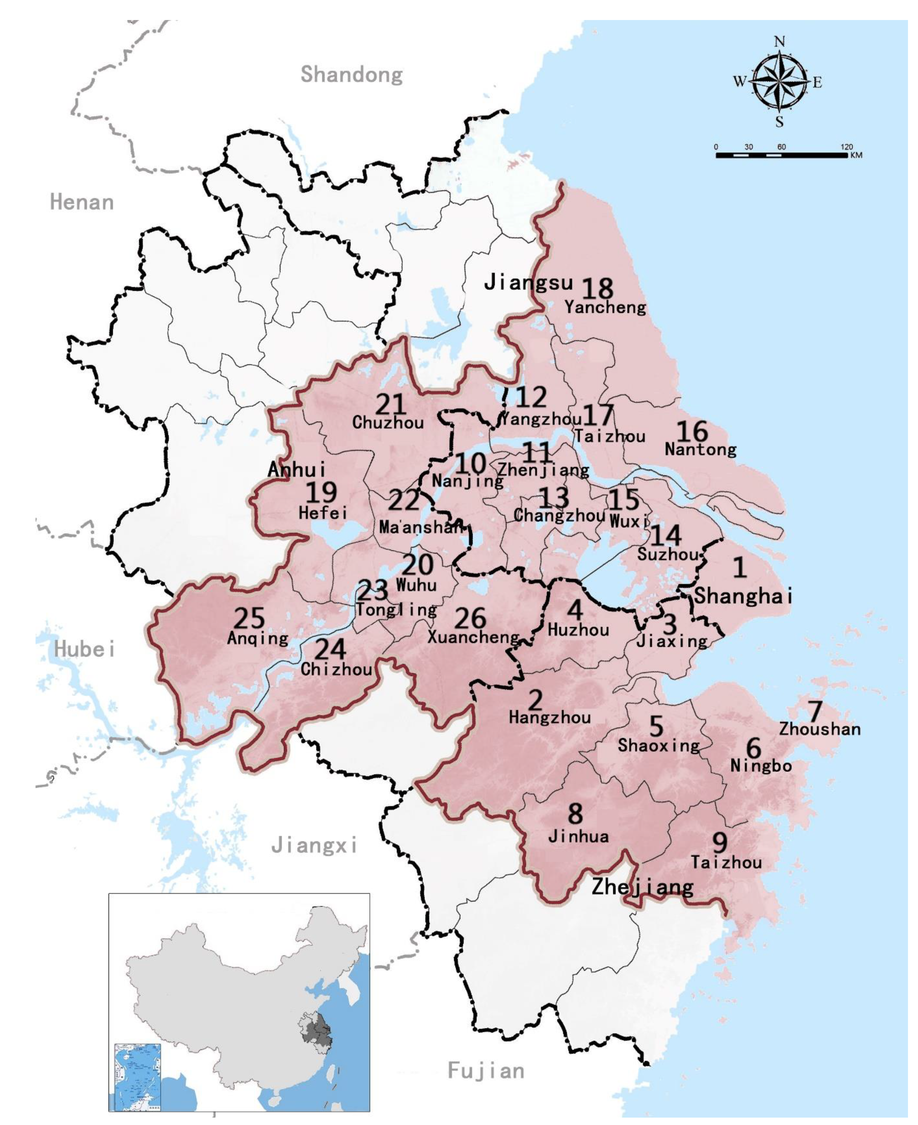
3.1. Research Target Area

The research target area in this paper is the YRDUA, including twenty-six cities of different sizes delineated by urban planning (Figure 2). In order to facilitate the viewing of subsequent figures, we numbered these twenty-six cities. The specific numbers and corresponding cities are shown in Table 1. Furthermore, we selected 2005, 2010, 2015, and 2018 as this paper’s time category for SNA. From 2005 to 2015, spanning a decade, the time period reflects the structural changes in CO2 emissions associated with different city sizes in the YRDUA. The data in 2018 are the closest to the current data that can be found. The YRDUA encompasses Shanghai and Jiangsu, Zhejiang, and Anhui Provinces, with Nanjing, Wuxi, Changzhou, Suzhou, Nantong, Yancheng, Yangzhou, Zhenjiang, and Taizhou in Jiangsu Province; Hangzhou, Ningbo, Jiaxing, Huzhou, Shaoxing, Jinhua, Zhoushan, and Taizhou in Zhejiang Province; and Hefei, Wuhu, Ma’anshan, Tongling, Anqing, Chuzhou, Chizhou, and Xuancheng in Anhui Province. The twenty-six cities cover a land area of 211,700 square kilometers [42].
According to the latest Chinese city-size classification standard (counting the number of permanent residents in urban areas) [43], the city-size hierarchy in the YRDUA includes five categories and seven subcategories. The research target area covers large, medium, and small cities. The YRDUA has one megacity behemoth, one megacity, thirteen large cities, seven medium cities, and four small cities.

3.2. Methods

3.2.1. A City-Size CO2 Emission Gravity Model

In order to find the CO2 emission associations in different city sizes in the YRDUA, this paper applies the gravity model commonly used in the theory of urban spatial interaction. Reilly was the first to use the gravity model for population geography based on the Newtonian mechanics theory of universal gravitation. He argued that a city’s attractiveness to its surrounding areas is proportional to its size and inversely proportional to the distance between them [44]. For the first time, Zipf utilized the theory of gravity in the spatial analysis of urban agglomerations [9]. Ullman’s (1954) point of view is “Geography as spatial interaction”, emphasizing the importance of spatial relationships to geographic research [45]. The gravity model gradually becomes the primary tool for quantitative research on spatial association. The basic equation of the gravity model is
G i j = k M i M j D i j b ,
where G i j represents the gravity between cities, and it can also be the strength of the association between cities; M i and M j represent the quality of city i and city j, i.e., the city size; D i j refers to the distance between city i and city j; and k is the gravitational coefficient. The contribution of the two cities, i and j, to the gravity between them cannot be precisely the same. The existing research confirmed the k value by the ratio of one city to the sum of two cities. Lastly, b is an index that measures the effect of friction over distance.
The gravity model is now widely used in various research fields, and there have been some studies on energy consumption in China [37,38]. In the context of this paper, the CO2 emissions in different city sizes represent the city’s quality, and the distance between cities was regarded as a straight-line distance from geographic locations rather than the distance in each traffic route. Through the introduction and literature review, this study used three indicators of permanent residents in an urban area (PRUA), gross domestic product (GDP), and urban built-up area (UBA) to represent the characteristic of city size. From Figure 3, the increase in the three city-size indicators expanded CO2 emissions. Therefore, it is reasonable to assume that city size impacts a city’s CO2 emissions. The improved gravity model is as follows:
r i j = k i j P i G i B i C i 4 P j G j B j C j 4 D i j k i j = C i C i + C j ,
where r i j   represents the CO2 emission gravity between city i and city j; P is PRUA; G is GDP; B is UBA; C is the CO2 emission intensity; D i j is the geographic straight-line distance between the government of city i and the government of city j. In order to avoid the excessive influence of distance on the association of CO2 emissions in different city sizes, we assigned b = 1 here. Lastly, k i j represents the contribution rate of city i to the CO2 emission gravity of city i, j.
We calculated Equation (2) to obtain the matrices of CO2 emission gravity and referred to the general practice, taking the row mean of the matrix as the critical value. It is assigned 1 when the gravity is greater than the critical value, which means they are related. Otherwise, it is assigned to 0. Then, the assignment matrix is transformed into a binary matrix:
L = ( l i j ) 26 × 26 ,   a n d   l i j = { 1 ,     r i j >   x ¯ 0 ,     r i j x ¯ ,
where L represents a binary matrix of CO2 emission gravity, and x ¯ is the row mean of the matrix.

3.2.2. Spatial Association Network Characteristic Indicators

This study systematically analyzed the networks from the macro level, the middle level, and the micro level. Then, we selected three characteristic indicators, including whole network analysis, spatial clustering analysis, and individual analysis.
Whole network analysis is network density, network connectedness, network hierarchy, and network efficiency [46].
Network density reflects how closely the actors in the network are related. The greater the density of the whole network, the more closely linked the network’s CO2 emissions of different city sizes. It shows that the network structure has a significant impact on CO2 emissions between cities. As a directed network, Equation (4) concerns network density, where D n is the network density, S is the number of relational ties, and N is the number of actors in the network:
D n = S N ( N 1 ) .
Network connectedness reflects the robustness and vulnerability of the network structures. If there is a direct or indirect relationship between any two actors in the network, the network has a strong association and robustness. Conversely, if any actor connects the relational ties, the network has solid single node dependence and vulnerability. Equation (5) concerns network connectedness, where R is the network connectedness, and V is the logarithmic number of unreachable actors in the network. The larger the R-value, the more robust the CO2 emission network structure of different city sizes:
R = 1 [ V N ( N 1 ) 2 ] .
Network hierarchy reflects the extent to which actors are asymmetrically reachable to each other. The higher the network hierarchy, the more pronounced the hierarchical structure among actors. It reflects the dominance or marginality of different city sizes in CO2 emissions. Equation (6) concerns network hierarchy, where H is the network hierarchy, A is the number of symmetrically reachable node logarithms in the network, and max(A) is the maximum possible value of the symmetrically reachable number of node logarithms in the network:
H = 1 A max ( A ) .
Network efficiency refers to the degree to which there are redundant relational ties. The lower the network efficiency, the more associations there are between actors, which means that the CO2 emissions in different city sizes are more closely linked, and the network is more complex and stable. Equation (7) concerns network efficiency, where E is the network efficiency, U is the number of redundant relational ties, and max(U) is the maximum possible value of the number of redundant lines:
E = 1 U max ( U ) .
Spatial clustering analysis concerns cohesive subgroups and focuses on the network’s internal structure. Wasserman et al. [46] concluded that “Cohesive subgroups are subsets of actors among whom there are relatively strong, direct, intense, frequent or positive ties.” Mutuality of ties and closeness or reachability of subgroup members are the properties [47]. Generally, cohesive subgroups divide the network into subgroups, and the roles and functions of each subgroup in the network are studied [48]. The first step in constructing the cohesive subgroups is to partition the network actors and obtain the density matrix. The standard methods are the convergence of iterated correlation (CONCOR) and hierarchical clustering. The second step is to convert the density calculated in the previous step into a value of 1 or 0 according to specific criteria. In the image matrix, a value greater than or equal to the standard value is represented by 1. Otherwise, it is represented by 0. The criteria used for relationships are different. The most commonly used criterion is the α-density index. α is the critical density value, which usually refers to the average density value of the whole network [49]. This study used CONCOR to build the subgroups and took the density of CO2 emission networks in different city sizes as the critical density value. According to the results, the YRDUA’s cities were divided into four subgroups to analyze their roles and functions.
Individual analysis is centrality, which indicates the status and role of network actors, including degree centrality, betweenness centrality, and closeness centrality [50].
Degree centrality reflects the position of actors in the network. Relative degree centrality refers to the ratio of the number of actors connected with any other actors in the total associations. Relative degree centrality is standardized degree centrality, as in Equation (8), where   P c   is the relative degree centrality and n is the number of others directly connected to the actor:
P c = n N 1 .
Betweenness centrality measures how an actor has relational ties and reflects how the actor acts as an intermediary for others. Relative betweenness centrality is standardized betweenness centrality. Suppose g j a is the number of shortest paths between actor j and actor a and the number of shortest paths through the third actor, i, that exists between j, and a is denoted by g j a ( i ) . The ability of i to control j and a is represented by b j a ( i ) , which is the probability that i is on the shortest path between j and a, i.e., b j a ( i ) = g j a ( i ) g j a , where Ija and j < a. The equation is as follows:
B c = 2 a N a N b j a ( i ) N 2 3 N + 2 , 0 < B c < 1 ,
where B c is the relative betweenness centrality and b j a ( i ) is the probability of i on the shortest path between j and a.
Closeness centrality is the sum of the shortcut distances between the actor and others in the network. Moreover, it reflects the degree to which others do not control the actor. An actor’s closeness centrality is higher if its distance to all others in the network is short. Relative closeness centrality is standardized closeness centrality, and the equation is as follows, where C c is the closeness centrality and d i j is the shortcut distance between actor i and actor j, i.e., the number of relational ties included in the shortcut:
C c = N 1 j = 1 N d i j

3.3. Data Sources

The urban CO2 emissions data (10,000 tons) came from the China Urban Energy and Emissions Comprehensive Evaluation Platform managed by the Center for Climate Change and Environmental Policy, the Chinese Academy for Environmental Planning. This platform mainly releases the following information: the China High Resolution Emission Gridded Data (CHRED), the latest progress of city greenhouse gas inventory data, and the original theory and practices in climate change. The China City Greenhouse Gas Working Group has established a relatively reliable and full-coverage dataset of Chinese urban greenhouse gas and CO2 emissions. The straight-line distance between city governments was measured with the BIGEMAP downloader. The data of PRUA (10,000 people), GDP (CNY 100 million), and UBA (km2) all came from China’s economic and social big data platform. GDP was deflated with 2005 as the base period to eliminate the impact of prices. This study used UCINET 6 for the network analysis.

4. Results and Discussion

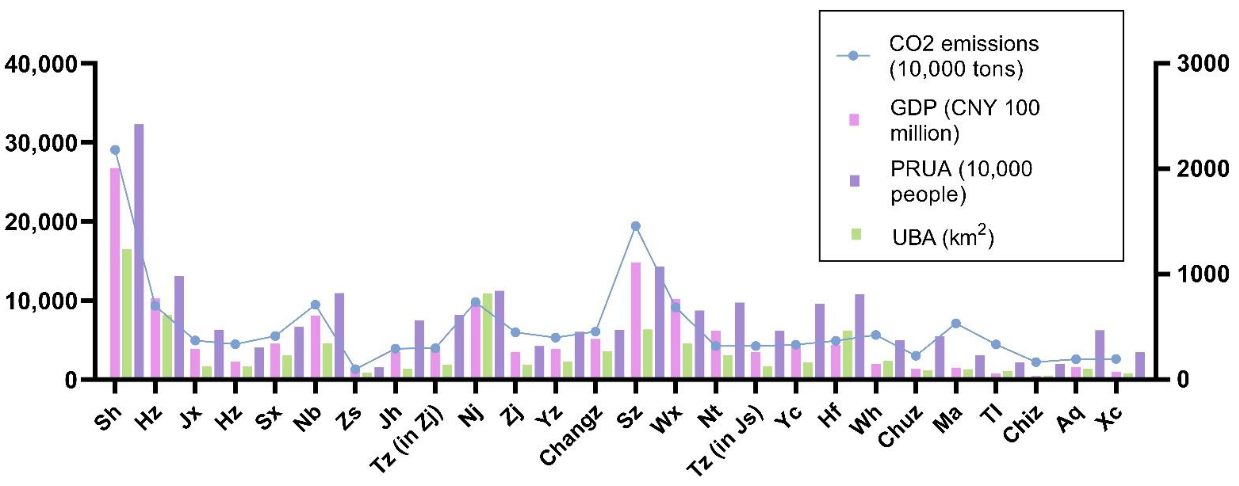
4.1. Temporal Change Tendency of CO2 Emission Intensity in Different City Sizes (2005, 2010, 2015, and 2018)

The CO2 emission intensity of different city sizes in the YRDUA shows a growing trend in chronological order. Spatial distribution emerges high in the east and low in the west. From Figure 4 and Table 1, CO2 emissions positively correlated with the city-size hierarchy in the YRDUA. According to each year’s data in the research target area, the CO2 emission intensity presents seven levels.
Shanghai is the only megacity behemoth in the city-size hierarchy and the highest contributor to CO2 emissions in the YRDUA. In the time category, Shanghai has the seventh-level CO2 emission intensity. This is related to its city’s status and economic strength. Shanghai is one of the municipalities directly under the Central Government in China and the national central city.
The other cities are concentrated in the second to fourth levels of CO2 emission intensity, and there are fewer cities in the highest and lowest levels, showing a normal distribution. Nanjing’s contribution to CO2 emissions in the urban agglomeration is not particularly prominent as a megacity. In the Type I large city aspect, Suzhou’s CO2 emission intensity leveled up after 2010 due to its continuously growing GDP and solid secondary industry. Hangzhou’s CO2 emission intensity leveled up after 2015. Hangzhou is an important international e-commerce center, and the tertiary industry is more developed than the secondary industry. Due to Hefei’s geographical location in Anhui Province, it has the lowest GDP among the three provinces in the YRDUA. Hefei’s CO2 emission intensity only entered the fourth level in 2015. As the provincial capital, Hefei has a relatively high CO2 emission intensity in Anhui Province. In the Type II large city aspect, Wuxi and Ningbo perform more prominently than other cities. In Anhui Province, Wuhu’s CO2 emission intensity is second only to Hefei. In 2010 and 2015, Ningbo’s CO2 emission intensity entered the sixth level with Suzhou. However, the CO2 emission intensity dropped in 2018 due to the transformation of the industrial structure of Ningbo. Meanwhile, Wuxi is a traditional industrial city and one of the economic centers in the YRDUA. Wuhu has become a subcenter city of Anhui Province, and its CO2 emission intensity is gradually rising. It is worth mentioning that the performance of Ma’anshan and Zhoushan as medium cities is quite different in their respective provinces. Ma’anshan’s traditional industries are mainly steel, automobiles, electricity, etc. The CO2 emission intensity of Ma’anshan is relatively high in Anhui Province. On the other hand, the CO2 emission intensity of Zhoushan is at a lower level. Zhoushan belongs to Zhejiang Province, an island city with low PRUA and a rich natural environment. Zhoushan’s mainstay is marine fisheries. In the Type I small city aspect, Tongling has a relatively superior performance in CO2 emission intensity due to its developed copper industry. Other unmentioned cities have corresponding CO2 emission intensity performances in their respective city-size hierarchy.

4.2. Spatial Association Networks of CO2 Emissions in Different City Sizes (2005, 2010, 2015, and 2018)

According to Equations (2) and (3), we calculated the gravity and spatial-association matrices of CO2 emissions in the YRDUA’s cities (2005, 2010, 2015, and 2018). Then, we used UCINET 6 to construct spatial-association networks of CO2 emissions in the time category (Figure 5). There are spatial associations of CO2 emissions among twenty-six cities of different sizes in 2005, 2010, 2015, and 2018. The spatial associations have become tighter over time. Meanwhile, Shanghai, Nanjing, Hangzhou, Changzhou, Wuxi, Suzhou, and Jiaxing make up the area where the spatial association of CO2 emissions is relatively concentrated. Some cities have few associations in the networks due to their remote geographical location and relatively small city size.

4.3. Structural Investigations of the Spatial-Association Networks

4.3.1. Whole Network Analysis

Whole network analysis is at the macro level. By substituting the association matrices of the time category into Equations (4)–(7), we calculated network density, network connectedness, network hierarchy, and network efficiency (Figure 6).
The relational ties and network density show an increasing trend from 2005 to 2015 and a slight decrease from 2015 to 2018. The Paris Agreement entered into force in 2016. China proposed establishing a national carbon-emissions trading system in the same year, introducing various policies [17]. This proves that these policies have had a positive impact on carbon reduction. The network connectedness (all years are 1) indicates that the CO2 emissions in the YRDUA’s cities are generally associated. The networks have no isolated nodes and have noticeable spatial-spillover effects. The networks have good connectivity, and the network structures are balanced. The network hierarchy (all years are 0) shows that the twenty-six cities have no significant relationship level in CO2 emissions, and the network level is not strict. This shows that the spatial influence of node center cities on peripheral cities is not sufficient. The network efficiency is generally high. This shows that the network conduction efficiency is higher and the CO2 emission interaction is faster, but there is also a certain CO2 emission interaction superposition phenomenon. Overall, the CO2 emissions in the YRDUA’s cities are gradually associated and have strong robustness. The network structures have become more robust and complex over time. However, due to a series of measures for energy conservation and emission reduction after 2016, the network structure in 2018 is slightly loose. It has been proved that energy conservation, emission reduction, and industrial structure transformation have a significant impact on the YRDUA’s CO2 emissions.
However, only focusing on carbon-reduction measures in node center cities cannot produce a long-term mechanism for the realization of the YRDUA’s carbon-reduction goals. How to strengthen the spatial-spillover effects of node center cities in the future will become an important direction in the transformation and development of the YRDUA’s low-carbon economy. While limiting the CO2 emissions of node center cities, the fairness of the CO2 emissions of other cities should also be considered.

4.3.2. Spatial Clustering Analysis

We used the cohesive subgroups to study the clusters at the middle level quantitatively. The research subject selected the association network in 2018 (Figure 7). Through CONCOR, the parameters set the maximum segmentation depth to 2, the convergence criterion to 0.2, and the maximum iteration to 25.
The whole network density in 2018 was 0.3508. If the density of a subgroup is more than 0.3508, it means that the density of the subgroup is more than the density of the whole network. Then, the subgroup has a solid central tendency and is assigned 1. Otherwise, it is assigned 0. According to this principle, the subgroup’s network density matrix and image matrix were obtained (Table 2). The image matrix intuitively expresses the spillover effects between subgroups and reflects the conduction mechanism of the CO2 emissions between subgroups. The twenty-six cities are divided into four subgroups.
Subgroup 1 and Subgroup 3 have associations of CO2 emissions within their subgroup and, respectively, receive the spillovers of the other two subgroups. Subgroup 1 mainly receives the spillovers of Subgroup 2 and Subgroup 3, and Subgroup 3 mainly receives the spillovers of Subgroup 1 and Subgroup 4. This shows that Subgroup 1 and Subgroup 3 are incredibly tight in the networks and provide associations. Subgroup 1 and Subgroup 3 are economically developed areas. Their CO2 emissions and energy consumption for production are significant. Similarly, the industrial agglomeration is evident, which leads to a larger city size. The division of inner cities in Subgroup 1 to Subgroup 3 is mainly represented by the grouping within each province. Individual cities have the form of inter-provincial groupings due to their prominent CO2 emissions and city size (larger or smaller).
Subgroup 2 is similar to Subgroup 4, and there are CO2 emission benefits and spillovers within each subgroup. They each have a spillover effect on the other subgroups. Neither Subgroup 2 nor Subgroup 4 accepts external spillovers. The two subgroups are relatively single in terms of industrial structure. They have abundant energy reserves, relatively slow economic development, and low demand for CO2 emissions. Meanwhile, their city sizes are smaller than Subgroup 1 and Subgroup 3, so they have spillovers of CO2 emissions to other subgroups. Moreover, the spillover directions of Subgroup 2 and Subgroup 4 are because of the geographical distance.
In particular, Subgroup 4 contains all eight cities in Anhui Province. The eight cities in Anhui Province were included in the planning of the YRDUA after 2014. Anhui Province has a relatively small economic aggregate and city size in the YRDUA, and it is geographically farther than the coast. After entering the planning of the YRDUA, Anhui Province’s economic aggregate and city size dramatically increased. In addition, Anhui Province has traditional mining cities such as Tongling and Ma’anshan, which provide many CO2 emissions. Therefore, Anhui Province as Subgroup 4 is typical in the cohesive subgroups.

4.3.3. Individual Analysis

We analyzed the status of each city’s nodes in the association networks by calculating the degree centrality, betweenness centrality, and closeness centrality. Furthermore, we explored the evolution of the central role in the association networks in the time category by calculating Equations (8)–(10).
The calculation results of network centrality are shown in Figure 8. The centralization is 42.33%, and the heterogeneity is 4.39%. Nanjing, Hangzhou, and Wuxi are at the center of the network, with more CO2 emission associations than other cities. Nanjing and Hangzhou are the provincial capitals of Jiangsu and Zhejiang Provinces, respectively. Their city size and CO2 emissions are large enough. They are located in the middle of the YRDUA, conducive to the mutual transport of CO2 emissions between cities. Wuxi’s outstanding performance in the network deserves attention. Wuxi’s GDP exceeded one trillion yuan in 2017, making it the third city in Jiangsu Province to enter the “Trillion Club” after Suzhou and Nanjing [51]. It has a significant CO2 emission performance. However, as the YRDUA’s most significant contributor to CO2 emissions, Shanghai does not perform as well as the above cities in terms of network centrality. Shanghai is ranked after Nantong and at the same level as Changzhou in terms of its network centrality. Shanghai’s geographical location is to the east of the coast and is relatively independent, which geo-blocks the CO2 emission associations with some cities. Furthermore, its powerful CO2 emissions and city size still belong to the network center’s forefront. Nantong surpasses Shanghai’s network centrality and proves its essential position in the YRDUA’s CO2 emissions. Nantong requires special attention in subsequent planning. In Anhui Province, only Hefei and Wuhu have strong network centrality, and the other six cities are all at the fringes of the network.
Changes in network degree centrality in the time category show that Shanghai, Hangzhou, Zhoushan, Jinhua, Nantong, and Hefei tend to become more central over time. On the contrary, cities such as Huzhou, Nanjing, and Yancheng have a downward trend in their degree centrality. Yangzhou, Suzhou, Wuxi, Tongling, and Xuancheng experienced a significant decrease in degree centrality compared with 2015. A series of energy-conservation and emission-reduction policies have had a specific inhibitory effect on the network degree centrality of cities.
According to the calculation results of the network’s betweenness centrality, Nanjing is the paramount “bridge” role in the network. Hangzhou, Wuxi, Nantong, Shanghai, and Changzhou have good synergy functions. Shen et al. [17] proposed that inter-provincial CO2 emissions may be exchanged first between provincial capitals and then between provincial capitals, consistent with actual political status. However, Hefei has no apparent performance from our calculation results. It is up for debate. Future emission-reduction policies can focus on these cities to block the exchange of CO2 emissions in other cities. Meanwhile, the betweenness centrality trend of the overall actors does not change much, and there are significant individual changes. For example, the betweenness centrality of Yangzhou, Changzhou, Suzhou, Wuxi, Yancheng, and Xuancheng has declined over time. The most significant changes are in Nanjing and Wuxi, but they still had a high betweenness centrality in 2018. Shanghai first experienced a sharp decline in 2015 and then rebounded in 2018. As a result, the central cities drive the continuous development of the YRDUA to drive the surrounding areas. The intermediary role of the central city is gradually weakening, but it still has an apparent central position.
The closeness centrality shows that Nanjing and Hangzhou are the primary regional nodes, and Wuxi is the auxiliary central node. Shanghai, Changzhou, Suzhou, Nantong, and Hefei are the central node cities of each coverage area. Nanjing has the highest closeness centrality, proving that Nanjing’s position as a central city in the network is very stable. Meanwhile, it has a shorter association distance with other cities and is not affected by other node cities at the highest level. Hangzhou, Wuxi, Shanghai, Changzhou, Suzhou, Nantong, and Hefei are high regional node centers. Therefore, these cities will be decisive for efficient energy conservation and emission reduction. They have a powerful radiation-driven effect. The changing trend of closeness centrality shows that Suzhou and Wuxi have experienced the fastest decline in closeness centrality. However, the closeness centrality of Shanghai, Hangzhou, Zhoushan, Nantong, and Hefei all continued to rise. Zhoushan has undergone significant changes due to its original city size and a small base of CO2 emissions. In addition to promoting carbon reduction, the other central cities on the rise must also play a synergistic role and optimize the industrial structure.

5. Conclusions

In this study, the classic gravity model was applied and improved. For the first time, we introduced the city-size theory into the gravity model of urban CO2 emissions and extended it from traditional demographic and economic indicators to spatial indicators. The spatial-association matrices and association networks were constructed by calculating the CO2 emission gravity of different city sizes in the YRDUA. We analyzed the spatial-association networks of CO2 emissions in different city sizes from the macro, middle, and micro levels. This paper is based on data up to 2018. We did not find more recent time node data. The cities in the research target area do not cover all city sizes and lack the Type II small city. The above potential influencing factors should be comprehensively considered in future research. Overall, the core findings and upcoming research can be summarized as follows:
  • The CO2 emission intensity shows that there is an increasing trend of different city sizes in the time sequence. In terms of spatial distribution, the trend is high in the east and low in the west. There is a positive correlation between CO2 emissions and city-size hierarchy. The CO2 emission intensity of cities presents a normal distribution, with less at the two ends and more in the middle. Shanghai is the highest contributor to CO2 emissions in the YRDUA. In the spatial-association networks (2005, 2010, 2015, and 2018), there are ubiquitous spatial associations of CO2 emissions of the twenty-six cities in the YRDUA, and the spatial network associations have become tighter with the evolution of time.
  • The whole network analysis reveals that the relational ties and the network density increased from 2005 to 2015 and experienced a slight decrease from 2015 to 2018. This provides that the various urban energy structure optimization policies implemented after 2016 effectively control CO2 emission intensity. The CO2 emissions of cities of different sizes in the YRDUA are generally associated. The networks have no isolated points and have apparent spatial-spillover effects. Meanwhile, the spillover relationship is not limited to geographically adjacent cities. The cities of different sizes in the YRDUA have no significant relationship level in CO2 emissions, and the network hierarchy is not strict. The degree of mutual influence of CO2 emissions in cities is very high. Over time, the whole network structures become more robust and complex with tighter associations.
  • The spatial clustering analysis indicates that the CO2 emissions and production energy consumption of the two subgroups headed by Shanghai and Nanjing are larger than the surrounding areas. Their industrial agglomeration is apparent, and the city size is large. Other subgroups have significant spillovers on these two subgroups’ CO2 emissions. The other two subgroups in Anhui Province and some cities in Zhejiang Province have relatively simple industrial structures, rich energy reserves, and relatively slow economic development. Therefore, they have spillovers of CO2 emissions to other subgroups and have spillovers of geographical characteristics. Subgroup 4 includes all the cities in Anhui Province, proving that the eight cities in Anhui Province have the characteristics of spatial clustering.
  • The individual analysis shows that Nanjing, Hangzhou, and Wuxi have more direct CO2 emission associations than other cities and are located in the center of networks. Nantong surpasses Shanghai in terms of network centrality. Only Hefei as the provincial capital and Wuhu as a subcenter city have strong network centrality in Anhui Province, and the remaining six cities are all at the fringes of networks. Shanghai, Hangzhou, Zhoushan, Jinhua, Nantong, and Hefei have become more central over time. On the contrary, Huzhou, Nanjing, Yancheng, etc., have a downward trend in degree centrality. Yangzhou, Suzhou, Wuxi, Tongling, and Xuancheng experienced a significant decrease in degree centrality compared with 2015. Therefore, energy-conservation and emission-reduction policies have a specific inhibitory effect on the network node centers. Nanjing plays the paramount “bridge” role in the networks. Hangzhou, Wuxi, Nantong, Shanghai, and Changzhou have good synergy functions. By focusing on these cities and controlling CO2 emissions, blocking the exchange of CO2 emissions in other cities can be achieved. It has formed a network form, with Nanjing and Hangzhou as the primary regional nodes and Wuxi as the auxiliary center node. Moreover, Shanghai, Changzhou, Suzhou, Nantong, and Hefei are node cities in each coverage area. Nanjing has the highest closeness centrality, indicating that Nanjing’s status as a central city in the networks is unshakable. Hangzhou, Wuxi, Shanghai, Changzhou, Suzhou, Nantong, and Hefei are high regional node centers. These cities will be the critical areas for carbon reduction in the future.
The above results show that it is difficult to achieve a long-term mechanism for carbon reduction by only increasing the carbon-reduction targets of each city. Establishing a carbon-reduction coordination mechanism under the transboundary effect is an inevitable choice to achieve future carbon-reduction goals. This paper aimed to realize the effective control of transboundary pollutants by comprehensively understanding the spatial associations of urban carbon emissions and the network structure characteristics. In order to achieve China’s carbon neutrality, it is necessary to not only consider the intuitive CO2 emission data but also pay more attention to the spatial-association effects of CO2 emissions in energy policy. In addition, the spatial association network structures of CO2 emissions can be adjusted and optimized in order to improve the spatial allocation efficiency of urban CO2 emissions. Although there is an obvious neighbor effect on CO2 emissions geographically, it creates conditions for transboundary energy saving in geographically adjacent areas. However, the spatial association of urban CO2 emissions presents a complex network structure, which provides a new impetus for building a transboundary energy-saving mechanism from the spatial dimension. Therefore, transboundary energy saving cannot be limited to geographically adjacent areas, but a transboundary energy-saving mechanism should be re-examined and constructed from the perspective of network structure.
This paper proposes the possibility of establishing a transboundary energy-saving mechanism to improve the efficiency of energy conservation and emission reduction. In order to better promote the carbon reduction of different city sizes in China and thus achieve carbon neutrality, the following issues should be further discussed in future research:
  • The CO2 emissions of different city sizes should be studied from more perspectives of urban agglomerations. This paper focused on the impact indicators of different city sizes and introduced the spatial indicator. The impact of more city-size indicators on CO2 emissions will be explored in the future. It is necessary to comprehensively assess the CO2 emission spatial structure at the urban aspect and explore the impact of more city-size indicators on CO2 emissions. The QAP regression analysis in social network analysis can also be considered.
  • A city is a complex system. The spatial-clustering analysis in this paper only covers a part of that system. The spatial-clustering analysis of urban networks includes methods such as cliques, k-cores, and lambda sets [46], which can reveal the hierarchical characteristics of the spatial association strength of urban networks at different levels. The quantitative analysis of the influencing indicators of cohesive subgroups can be carried out from various perspectives.

Author Contributions

Conceptualization, W.L.; Data curation, W.L.; Formal analysis, W.L. and Y.S.; Funding acquisition, Y.K.; Investigation, W.L. and Y.S.; Methodology, W.L.; Project administration, Y.S.; Resources, W.L. and W.C.; Software, Y.K. and H.R.; Supervision, W.C.; Validation, W.L., Y.S. and W.C.; Visualization, W.L. and Y.S.; Writing—original draft, W.L.; Writing—review & editing, W.L. All authors have read and agreed to the published version of the manuscript.

Funding

The study was funded by the Innovation Strategy Research Program of the Fujian Science and Technology Department in 2021 (no. 2021R0067).

Institutional Review Board Statement

Not applicable.

Informed Consent Statement

Not applicable.

Data Availability Statement

Raw data available at https://wxccg.cityghg.com/ (accessed on 3 September 2021) and https://data.cnki.net/HomeNew/index (accessed on 15 September 2021). The data that support the plots within this paper and other findings of this study are available from the corresponding author upon reasonable request.

Conflicts of Interest

The authors declare no conflict of interest.

Abbreviations

YRDUAYangtze River Delta Urban Agglomeration
SNASocial Network Analysis
CHRED China High Resolution Emission Gridded Data
PRUAPermanent Residents in An Urban Area
GDPGross Domestic Product
UBAUrban Built-up Area
CONCORConvergence of Iterated
Correlation
UCINETUniversity of California at Irvine NETwork

References

  1. Wu, X.X.; Huang, Y.; Gao, J. Impact of industrial agglomeration on new-type urbanization: Evidence from Pearl River Delta urban agglomeration of China. Int. Rev. Econ. Financ. 2022, 77, 312–325. [Google Scholar] [CrossRef]
  2. Fragkias, M.; Lobo, J.; Strumsky, D.; Seto, K.C. Does Size Matter? Scaling of CO2 Emissions and U.S. Urban Areas. PLoS ONE 2013, 8, e64727. [Google Scholar] [CrossRef] [PubMed]
  3. Ma, M.D.; Ma, X.; Cai, W.; Cai, W.G. Low carbon roadmap of residential building sector in China: Historical mitigation and prospective peak. Appl. Energy 2020, 273, 115247. [Google Scholar] [CrossRef]
  4. Mi, Z.; Zhang, Y.; Guan, D.; Shan, Y.; Liu, Z.; Cong, R.; Yuan, X.-C.; Wei, Y.-M. Consumption-based emission accounting for Chinese cities. Appl. Energy 2016, 184, 1073–1081. [Google Scholar] [CrossRef] [Green Version]
  5. Ma, M.; Rozema, J.; Gianoli, A.; Zhang, W. The Impacts of City Size and Density on CO2 Emissions: Evidence from the Yangtze River Delta Urban Agglomeration. Appl. Spat. Anal. Policy 2021, 1–27. [Google Scholar] [CrossRef]
  6. Sun, Z.; Ma, Z.; Ma, M.; Cai, W.; Xiang, X.; Zhang, S.; Chen, M.; Chen, L. Carbon Peak and Carbon Neutrality in the Building Sector: A Bibliometric Review. Buildings 2022, 12, 128. [Google Scholar] [CrossRef]
  7. Li, K.; Ma, M.D.; Xiang, X.W.; Feng, W.; Ma, Z.L.; Cai, W.G.; Ma, X. Carbon reduction in commercial building operations: A provincial retrospection in China. Appl. Energy 2022, 306, 118098. [Google Scholar] [CrossRef]
  8. Cheng, S.L.; Fan, W.; Meng, F.X.; Chen, J.D.; Cai, B.F.; Liu, G.Y.; Liang, S.; Song, M.L.; Zhou, Y.; Yang, Z.F. Toward low-carbon development: Assessing emissions-reduction pressure among Chinese cities. J. Environ. Manag. 2020, 271, 111036. [Google Scholar] [CrossRef]
  9. Fang, C.L.; Yu, D.L. Urban agglomeration: An evolving concept of an emerging phenomenon. Landsc. Urban Plann. 2017, 162, 126–136. [Google Scholar] [CrossRef]
  10. Liang, L.W.; Wang, Z.B.; Li, J.X. The effect of urbanization on environmental pollution in rapidly developing urban agglomerations. J. Clean. Prod. 2019, 237, 117649. [Google Scholar] [CrossRef]
  11. Teaford, J.C.; ProQuest. The Metropolitan Revolution: The Rise of Post-Urban America; Columbia University Press: New York, NY, USA, 2006; 306p. [Google Scholar]
  12. Yao, F.; Zhu, H.S.; Wang, M.J. The Impact of Multiple Dimensions of Urbanization on CO2 Emissions: A Spatial and Threshold Analysis of Panel Data on China’s Prefecture-Level Cities. Sustain. Cities Soc. 2021, 73, 103113. [Google Scholar] [CrossRef]
  13. Ou, J.P.; Liu, X.P.; Wang, S.J.; Xie, R.; Li, X. Investigating the differentiated impacts of socioeconomic factors and urban forms on CO2 emissions: Empirical evidence from Chinese cities of different developmental levels. J. Clean. Prod. 2019, 226, 601–614. [Google Scholar] [CrossRef]
  14. Wang, S.; Fang, C.; Wang, Y. Spatiotemporal variations of energy-related CO2 emissions in China and its influencing factors: An empirical analysis based on provincial panel data. Renew Sust. Energ. Rev. 2016, 55, 505–515. [Google Scholar] [CrossRef]
  15. Wang, Y.N.; Chen, W.; Kang, Y.Q.; Li, W.; Guo, F. Spatial correlation of factors affecting CO2 emission at provincial level in China: A geographically weighted regression approach. J. Clean. Prod. 2018, 184, 929–937. [Google Scholar] [CrossRef]
  16. Outline of the Yangtze River Delta Regional Integrated Development Planning; People’s Publishing House: Beijing, China, 2019; pp. 7–9.
  17. Shen, W.R.; Liang, H.W.; Dong, L.; Ren, J.Z.; Wang, G.J. Synergistic CO2 reduction effects in Chinese urban agglomerations: Perspectives from social network analysis. Sci. Total Environ. 2021, 798, 149352. [Google Scholar] [CrossRef]
  18. Energy Development Strategic Action Program: 2014–2020; People’s Publishing House: Beijing, China, 2014.
  19. Cui, Y.F.; Li, L.; Chen, L.Q.; Zhang, Y.; Cheng, L.; Zhou, X.S.; Yang, X.Y. Land-Use Carbon Emissions Estimation for the Yangtze River Delta Urban Agglomeration Using 1994–2016 Landsat Image Data. Remote Sens. 2018, 10, 1334. [Google Scholar] [CrossRef] [Green Version]
  20. Zhang, S.F.; Ma, M.D.; Li, K.; Ma, Z.L.; Feng, W.; Cai, W.G. Historical carbon abatement in the commercial building operation: China versus the US. Energ. Econ. 2022, 105, 105712. [Google Scholar] [CrossRef]
  21. Huo, T.F.; Li, X.H.; Cai, W.G.; Zuo, J.; Jia, F.Y.; Wei, H.F. Exploring the impact of urbanization on urban building carbon emissions in China: Evidence from a provincial panel data model. Sustain. Cities Soc. 2020, 56, 105712. [Google Scholar] [CrossRef]
  22. Xiang, X.W.; Ma, X.; Ma, Z.L.; Ma, M.D.; Cai, W.G. Python-LMDI: A Tool for Index Decomposition Analysis of Building Carbon Emissions. Buildings 2022, 12, 83. [Google Scholar] [CrossRef]
  23. Gao, J.X.; Zhong, X.Y.; Cai, W.G.; Ren, H.; Huo, T.F.; Wang, X.; Mi, Z.F. Dilution effect of the building area on energy intensity in urban residential buildings. Nat. Commun. 2019, 10, 4944. [Google Scholar] [CrossRef]
  24. Zhang, S.F.; Xiang, X.W.; Ma, Z.L.; Ma, M.D.; Zou, C.C. Carbon Neutral Roadmap of Commercial Building Operations by Mid-Century: Lessons from China. Buildings 2021, 11, 510. [Google Scholar] [CrossRef]
  25. Xiang, X.W.; Ma, X.; Ma, Z.L.; Ma, M.D. Operational Carbon Change in Commercial Buildings under the Carbon Neutral Goal: A LASSO-WOA Approach. Buildings 2022, 12, 54. [Google Scholar] [CrossRef]
  26. Wang, B.; Sun, Y.F.; Wang, Z.H. Agglomeration effect of CO2 emissions and emissions reduction effect of technology: A spatial econometric perspective based on China’s province-level data. J. Clean. Prod. 2018, 204, 96–106. [Google Scholar] [CrossRef]
  27. Shi, K.F.; Chen, Y.; Li, L.Y.; Huang, C. Spatiotemporal variations of urban CO2 emissions in China: A multiscale perspective. Appl. Energy 2018, 211, 218–229. [Google Scholar] [CrossRef]
  28. Liu, B.Q.; Tian, C.; Li, Y.Q.; Song, H.H.; Ma, Z.X. Research on the effects of urbanization on carbon emissions efficiency of urban agglomerations in China. J. Clean. Prod. 2018, 197, 1374–1381. [Google Scholar] [CrossRef]
  29. Su, W.S.; Liu, Y.Y.; Wang, S.J.; Zhao, Y.B.; Su, Y.X.; Li, S.J. Regional inequality, spatial spillover effects, and the factors influencing city-level energy-related carbon emissions in China. J. Geogr. Sci. 2018, 28, 495–513. [Google Scholar] [CrossRef] [Green Version]
  30. Yu, X.; Wu, Z.Y.; Zheng, H.R.; Li, M.Q.; Tan, T.L. How urban agglomeration improve the emission efficiency ? A spatial econometric analysis of the Yangtze River Delta urban agglomeration in China. J. Environ. Manag. 2020, 260, 110061. [Google Scholar] [CrossRef]
  31. Han, F.; Xie, R.; Lu, Y.; Fang, J.Y.; Liu, Y. The effects of urban agglomeration economies on carbon emissions: Evidence from Chinese cities. J. Clean. Prod. 2018, 172, 1096–1110. [Google Scholar] [CrossRef]
  32. Zhang, W.; Feng, P.F. Differentiation research of CO2 emissions from energy consumption and their influencing mechanism on the industrial enterprises above designated size in Chinese industrial cities: Based on geographical detector method. Nat. Hazards 2020, 102, 645–658. [Google Scholar] [CrossRef] [Green Version]
  33. Miao, Z.; Balezentis, T.; Tian, Z.H.; Shao, S.; Geng, Y.; Wu, R. Environmental Performance and Regulation Effect of China’s Atmospheric Pollutant Emissions: Evidence from “Three Regions and Ten Urban Agglomerations”. Environ. Resour. Econ. 2019, 74, 211–242. [Google Scholar] [CrossRef]
  34. Barthélemy, M. Spatial networks. Phys. Rep. 2011, 499, 1–101. [Google Scholar] [CrossRef] [Green Version]
  35. Pflieger, G.; Rozenblat, C. Introduction. Urban Networks and Network Theory: The City as the Connector of Multiple Networks. Urban Stud. 2010, 47, 2723–2735. [Google Scholar] [CrossRef] [Green Version]
  36. Wolfe, A.W. Social Network Analysis: Methods and Applications. Contemp. Sociol. 1995, 91, 219–220. [Google Scholar] [CrossRef]
  37. Bai, C.Q.; Zhou, L.; Xia, M.L.; Feng, C. Analysis of the spatial association network structure of China’s transportation carbon emissions and its driving factors. J. Environ. Manag. 2020, 253, 109765. [Google Scholar] [CrossRef] [PubMed]
  38. He, Y.Y.; Wei, Z.X.; Liu, G.Q.; Zhou, P. Spatial network analysis of carbon emissions from the electricity sector in China. J. Clean. Prod. 2020, 262, 121193. [Google Scholar] [CrossRef]
  39. Su, Y.; Yu, Y.Q. Spatial association effect of regional pollution control. J. Clean. Prod. 2019, 213, 540–552. [Google Scholar] [CrossRef]
  40. Barthelemy, M. Morphogenesis of Spatial Networks; Lecture Notes in Morphogenesis; Springer: Berlin/Heidelberg, Germany, 2018; pp. i–xix, 319–331. [Google Scholar] [CrossRef]
  41. Song, J.; Feng, Q.; Wang, X.; Fu, H.; Jiang, W.; Chen, B. Spatial Association and Effect Evaluation of CO2 Emission in the Chengdu-Chongqing Urban Agglomeration: Quantitative Evidence from Social Network Analysis. Sustainability 2018, 11, 1. [Google Scholar] [CrossRef] [Green Version]
  42. Notice on Printing and Distributing the Development Planning of the Yangtze River Delta Urban Agglomeration. Available online: https://www.ndrc.gov.cn/xxgk/zcfb/ghwb/201606/t20160603_962187.html?code=&state=123 (accessed on 1 June 2016).
  43. The State Council issued the “Notice on Adjusting the Criteria for City Size Division”. Jiangsu Urban Plan. 2014, 11, 47–47.
  44. Reilly, W.J. Methods for the Study of Retail Relationships; The University of Texas Bulletin: Austin, TX, USA, 1929; 50p. [Google Scholar]
  45. Ullman, E.L.; Boyce, R.R. Geography as Spatial Interaction; University of Washington Press: Seattle, WA, USA, 1980; p. xix. 231p. [Google Scholar]
  46. Wasserman, S.; Faust, K. Social Network Analysis: Methods and Applications; Cambridge University Press: Cambridge, UK, 1994; p. xxxi. 825p. [Google Scholar]
  47. Chen, R.C.S.; Yang, S.J.H. Applying DNA computation to intractable problems in social network analysis. Biosystems 2010, 101, 222–232. [Google Scholar] [CrossRef]
  48. Tsvetovat, M.; Kouznetsov, A. Social Network Analysis for Startups; O’Reilly: Beijing, China; Farnham, UK, 2011; p. xi. 174p. [Google Scholar]
  49. Scott, J. Social network analysis: A Handbook; SAGE Publications: London, UK; Newbury Park, CA, USA, 1991; p. x. 210p. [Google Scholar]
  50. Freeman, L.C. Centrality in social networks conceptual clarification. Soc. Netw. 1978, 1, 215–239. [Google Scholar] [CrossRef] [Green Version]
  51. Wuxi: Seventy Years of Trials and Hardships, Wuxi’s Old Appearance Has Changed. Available online: http://jszd.stats.gov.cn/ztzl/tjkfr_1/70zncj/201909/t20190919_3903.html (accessed on 19 September 2019).
Figure 1. Flowchart of this study.
Buildings 12 00617 g001
Figure 2. Geographical locations and numbers of the YRDUA’s twenty-six cities.
Buildings 12 00617 g002
Figure 3. Statistics on the CO2 emissions, GDP, PRUA, and UBA of the YRDUA’s twenty-six cities in 2018.
Buildings 12 00617 g003
Figure 4. CO2 emission intensity of the YRDUA’s cities: (a) in 2005; (b) in 2010; (c) in 2015; (d) in 2018.
Buildings 12 00617 g004
Figure 5. Spatial-association networks of CO2 emissions in the YRDUA’s cities: (a) in 2005; (b) in 2010; (c) in 2015; (d) in 2018.
Buildings 12 00617 g005
Figure 6. Whole network analysis of CO2 emissions in the YRDUA’s cities: (a) relational ties; (b) network density; (c) network connectedness and network hierarchy; (d) network efficiency.
Buildings 12 00617 g006
Figure 7. Spatial clustering analysis of CO2 emissions in the YRDUA’s cities in 2018.
Buildings 12 00617 g007
Figure 8. Individual analysis of CO2 emissions in the YRDUA’s cities: (a) degree centrality; (b) betweenness centrality; (c) closeness centrality.
Buildings 12 00617 g008
Table 1. Classification of city size in the YRDUA.
City SizeClassification Standard (10,000 People)City (Number in the Research)
Megacity Behemoth>1000Shanghai (1)
Megacity500–1000Nanjing (10)
Large CityⅠ Large City300–500Hangzhou (2), Hefei (19), and Suzhou (14)
Ⅱ Large City100–300Wuxi (15), Ningbo (6), Nantong (16), Changzhou (13), Shaoxing (5), Wuhu (20), Yancheng (18), Yangzhou (12), Taizhou (in Jiangsu) (17), and Taizhou (in Zhejiang) (9)
Medium City50–100Zhenjiang (11), Huzhou (4), Jiaxing (3), Ma’anshan (22), Anqing (25), Jinhua (8), and Zhoushan (7)
Small CityⅠ Small City20–50Tongling (23), Chuzhou (21), Xuancheng (26), and Chizhou (24)
Ⅱ Small City<20None
Table 2. Density matrix and image matrix of four subgroups in 2018.
SubgroupDensity MatrixImage Matrix
12341234
11.0000.2780.3610.0001010
20.9720.5000.1390.0211100
30.6940.0000.9000.1041010
40.2920.0000.3960.5180011
Publisher’s Note: MDPI stays neutral with regard to jurisdictional claims in published maps and institutional affiliations.

