A Framework of Community Pedestrian Network Design Based on Urban Network Analysis
Abstract
:1. Introduction
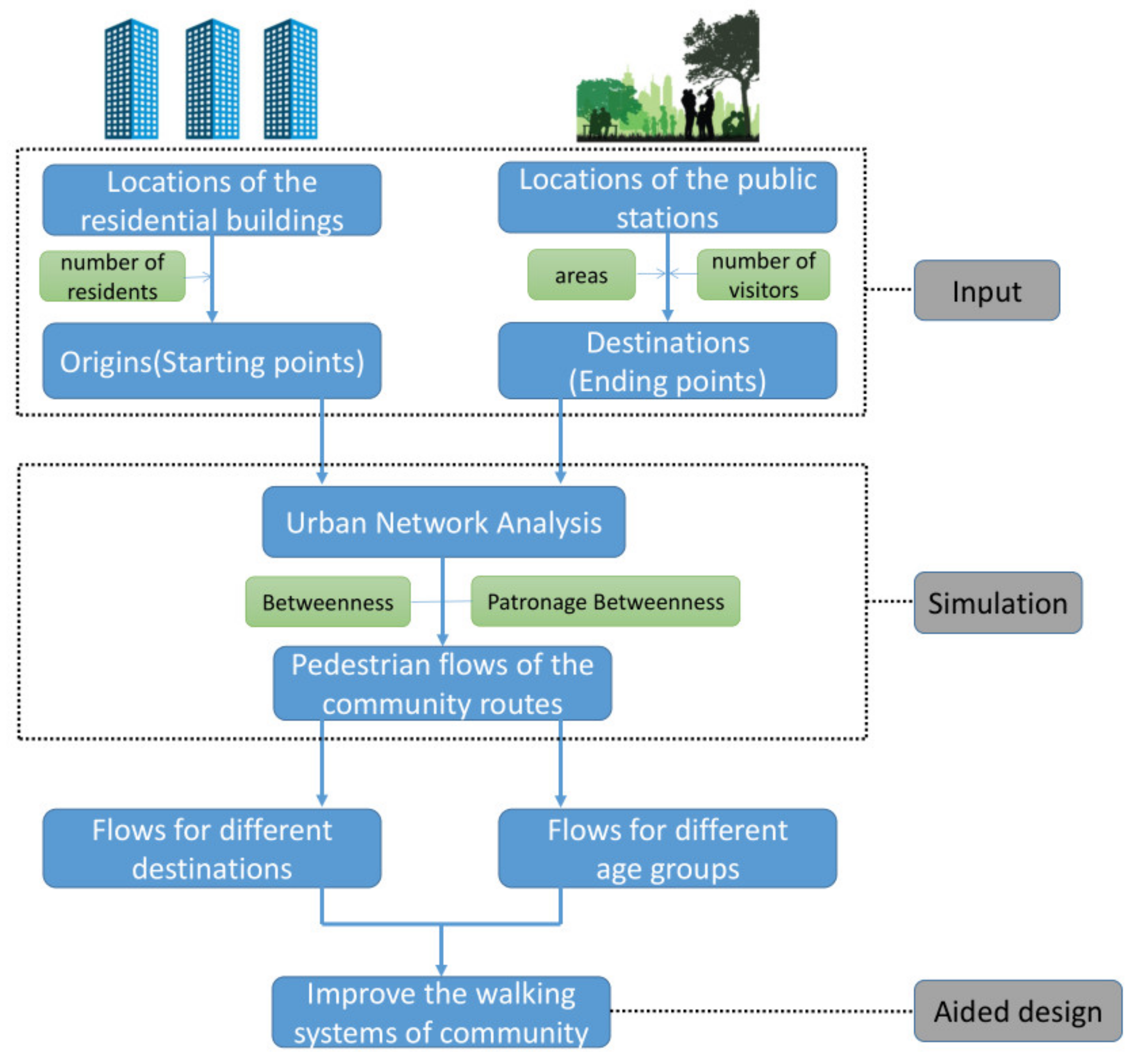
2. Methodology
3. Case Study
3.1. Case Introduction and Simulation Settings
3.1.1. Case Introduction
3.1.2. Simulation Settings
3.2. Results and Discussion
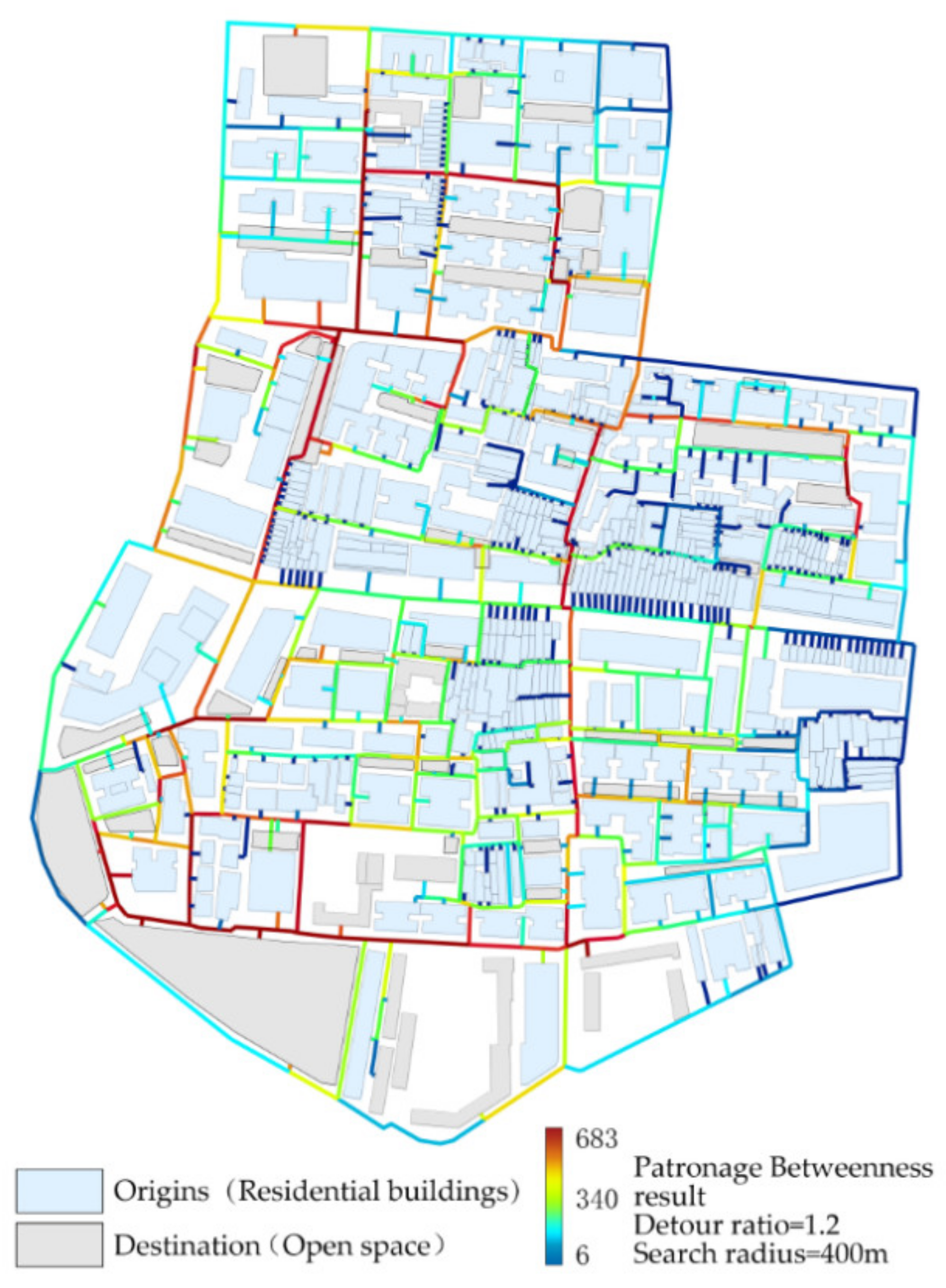
3.2.1. The Pedestrian Flow from Residential Building to Public Activity Area
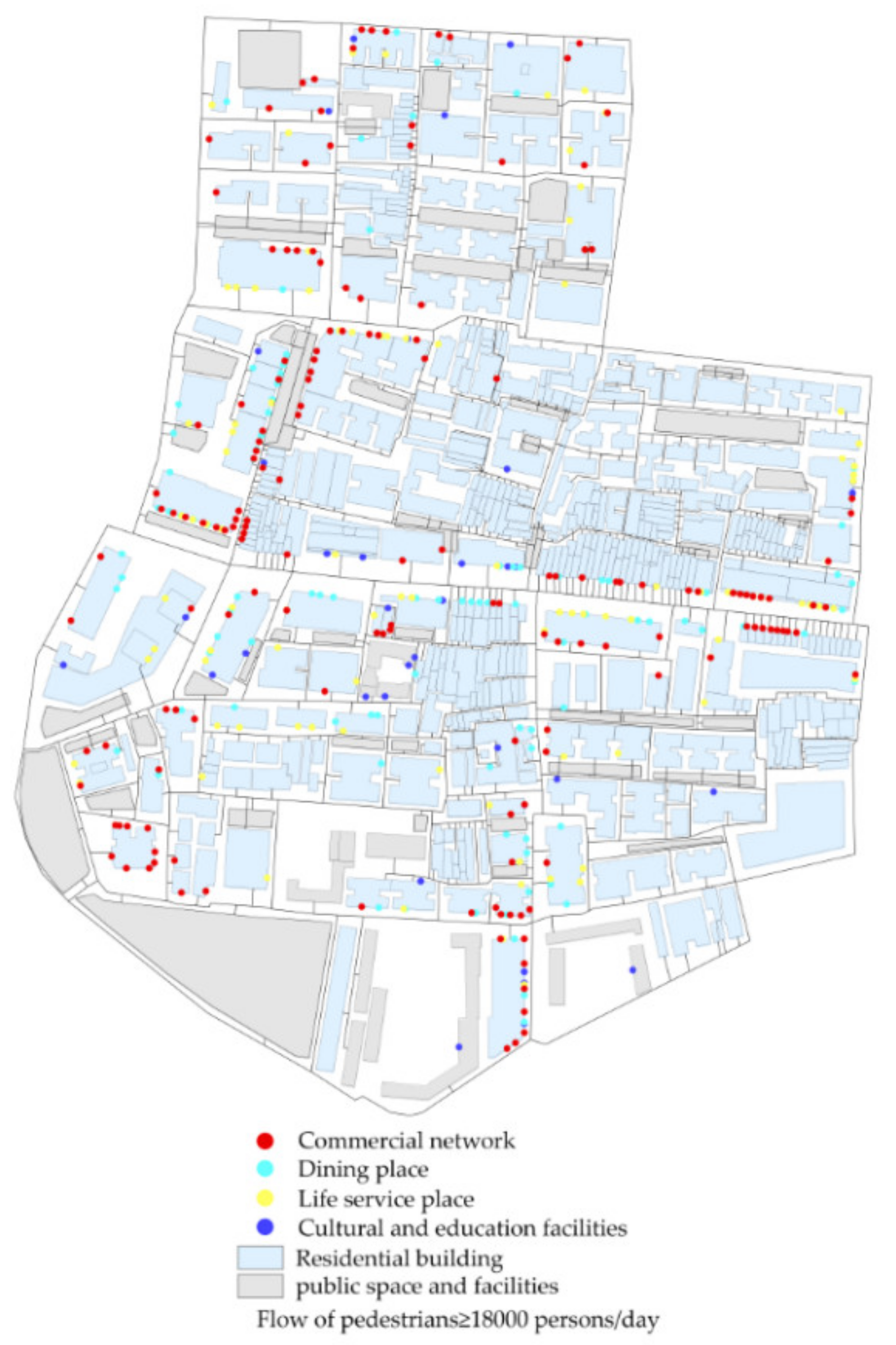
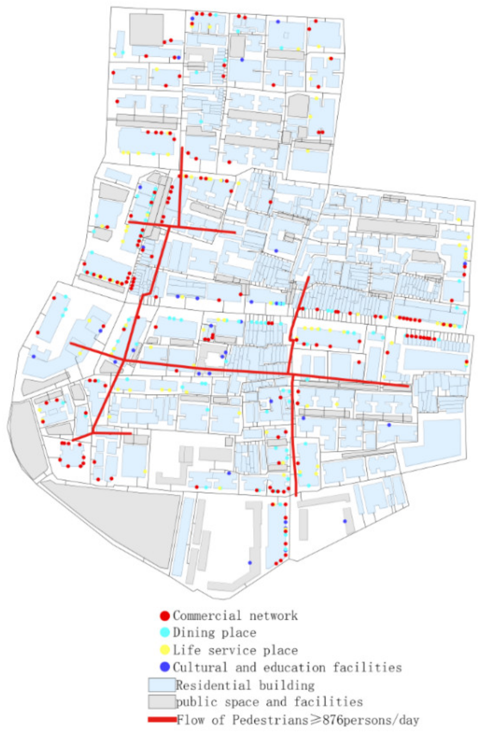
3.2.2. The Pedestrian Flow from Residential Buildings to Commercial Facilities
3.2.3. Pedestrian Flow Simulation against Different Age Groups
- Simulation of pedestrian route choice of children (0–14 years old).
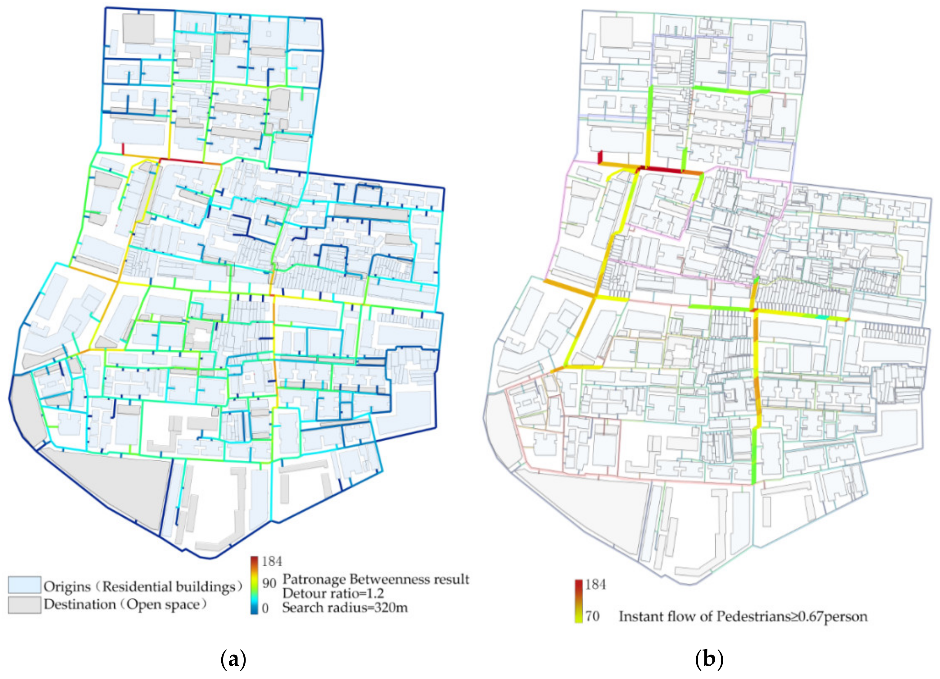
- Simulation of pedestrian route choice of the young and middle-aged people (15–59 years old).
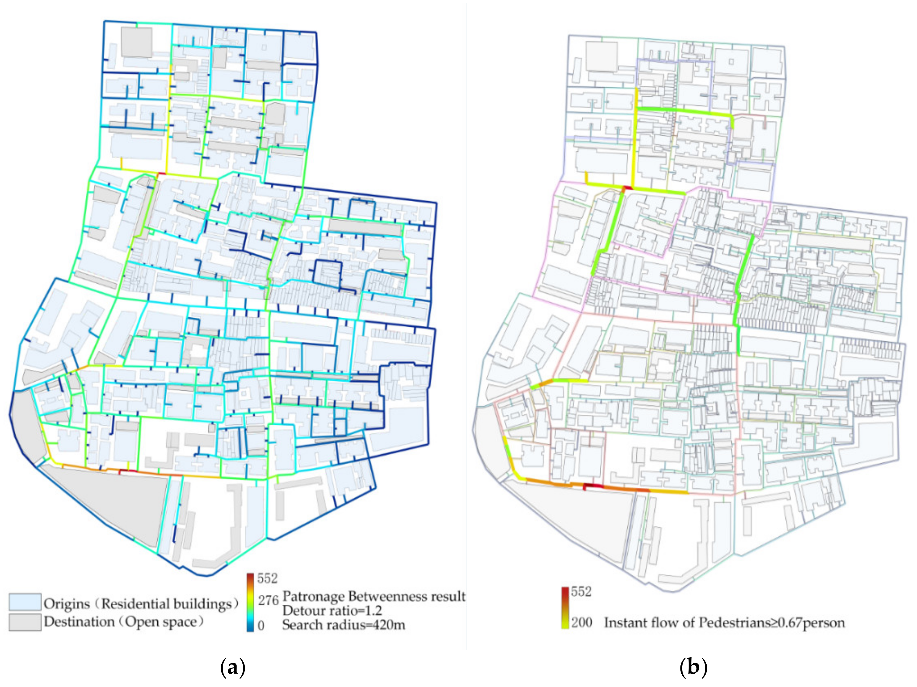
- Simulation of pedestrian route choice of the elderly people (≥60 years old).
- Simulation parameters: Detroit ratio = 1.2; Search radius = 320 m; β = 0.004.
4. Conclusions and Future Work
Author Contributions
Funding
Institutional Review Board Statement
Informed Consent Statement
Data Availability Statement
Conflicts of Interest
References
- Wolch, J.R.; Byrne, J.; Newell, J.P. Urban green space, public health, and environmental justice: The challenge of making cities ‘just green enough’. Landsc. Urban Plan. 2014, 125, 234–244. [Google Scholar] [CrossRef] [Green Version]
- Tian, Z.; Yang, W.; Zhang, T.; Ai, T.; Wang, Y. Characterizing the activity patterns of outdoor jogging using massive multi-aspect trajectory data. Comput. Environ. Urban Syst. 2022, 95, 101804. [Google Scholar] [CrossRef]
- Liu, Y.; Hu, J.; Yang, W.; Luo, C. Effects of urban park environment on recreational jogging activity based on trajectory data: A case of Chongqing, China. Urban For. Urban Green. 2022, 67, 127443. [Google Scholar] [CrossRef]
- Frank, L.D.; Engelke, P. Multiple Impacts of the Built Environment on Public Health: Walkable Places and the Exposure to Air Pollution. Int. Reg. Sci. Rev. 2005, 28, 193–216. [Google Scholar] [CrossRef]
- Mölenberg, F.J.M.; Noordzij, J.M.; Burdorf, A.; van Lenthe, F.J. New physical activity spaces in deprived neighborhoods: Does it change outdoor play and sedentary behavior? A natural experiment. Health Place 2019, 58, 102151. [Google Scholar] [CrossRef]
- Chang, P.-J. Effects of the built and social features of urban greenways on the outdoor activity of older adults. Landsc. Urban Plan. 2020, 204, 103929. [Google Scholar] [CrossRef]
- Hankey, S.; Lindsey, G.; Marshall, J.D. Population-Level Exposure to Particulate Air Pollution during Active Travel: Planning for Low-Exposure, Health-Promoting Cities. Environ. Health Perspect 2017, 125, 527–534. [Google Scholar] [CrossRef]
- Sharmeen, F.; Timmermans, H. Walking down the habitual lane: Analyzing path dependence effects of mode choice for social trips. J. Transp. Geogr. 2014, 39, 222–227. [Google Scholar] [CrossRef]
- Yokohari, M.; Bolthouse, J. Planning for the slow lane: The need to restore working greenspaces in maturing contexts. Landsc. Urban Plan. 2011, 100, 421–424. [Google Scholar] [CrossRef]
- Hosford, K.; Beairsto, J.; Winters, M. Is the 15-minute city within reach? Evaluating walking and cycling accessibility to grocery stores in Vancouver. Transp. Res. Interdiscip. Perspect. 2022, 14, 100602. [Google Scholar] [CrossRef]
- Lu, Y. The Association of Urban Greenness and Walking Behavior: Using Google Street View and Deep Learning Techniques to Estimate Residents’ Exposure to Urban Greenness. Int. J. Environ. Res. Public Health 2018, 15, 1576. [Google Scholar] [CrossRef] [Green Version]
- Suminski, R.R.; Dominick, G.M. A comprehensive evaluation of physical activity on sidewalks and streets in three U.S. Cities. Prev. Med. Rep. 2022, 26, 101696. [Google Scholar] [CrossRef]
- Liu, Z.; Kemperman, A.; Timmermans, H. Correlates of frequency of outdoor activities of older adults: Empirical evidence from Dalian, China. Travel Behav. Soc. 2021, 22, 108–116. [Google Scholar] [CrossRef]
- Dill, J.; Mohr, C.; Ma, L. How Can Psychological Theory Help Cities Increase Walking and Bicycling? J. Am. Plan. Assoc. 2014, 80, 36–51. [Google Scholar] [CrossRef]
- Sundquist, K.; Eriksson, U.; Kawakami, N.; Skog, L.; Ohlsson, H.; Arvidsson, D. Neighborhood walkability, physical activity, and walking behavior: The Swedish Neighborhood and Physical Activity (SNAP) study. Soc. Sci. Med. 2011, 72, 1266–1273. [Google Scholar] [CrossRef]
- Weng, M.; Ding, N.; Li, J.; Jin, X.; Xiao, H.; He, Z.; Su, S. The 15-minute walkable neighborhoods: Measurement, social inequalities and implications for building healthy communities in urban China. J. Transp. Health 2019, 13, 259–273. [Google Scholar] [CrossRef]
- Caselli, B.; Carra, M.; Rossetti, S.; Zazzi, M. Exploring the 15-minute neighbourhoods. An evaluation based on the walkability performance to public facilities. Transp. Res. Procedia 2022, 60, 346–353. [Google Scholar] [CrossRef]
- Abdelfattah, L.; Deponte, D.; Fossa, G. The 15-minute city: Interpreting the model to bring out urban resiliencies. Transp. Res. Procedia 2022, 60, 330–337. [Google Scholar] [CrossRef]
- National Spatial Planning and Regional Policy Bureau, Ministry of Land, Infrastructure, Transport and Tourism of Japan. Japan’s National Land Formation Plan: National Planning: The Sixth National Land Planning of Japan; Geological Publishing House: Bath, UK, 2011. [Google Scholar]
- Shanghai Municipal Administration of Planning, Land and Resources. Shanghai 15-minute Community Living Circle Planning Research and Practice; Shanghai People’s Publishing House: Shanghai, China, 2017. [Google Scholar]
- Sevtsuk, A.; Basu, R.; Li, X.; Kalvo, R. A big data approach to understanding pedestrian route choice preferences: Evidence from San Francisco. Travel Behav. Soc. 2021, 25, 41–51. [Google Scholar] [CrossRef]
- Speck, J. Walkable City: How Downtown Can Save America, One Step at a Time; Farrar, Straus and Giroux: New York, NY, USA, 2012. [Google Scholar]
- Sevtsuk, A. Urban Network Analysis. Tools for Modeling Pedestrian and Bicycle Trips in Cities; Harvard Graduate School of Design: Cambridge, MA, USA, 2018; p. 136. [Google Scholar]
- Li, M.; Liu, J.; Lin, Y.; Xiao, L.; Zhou, J. Revitalizing historic districts: Identifying built environment predictors for street vibrancy based on urban sensor data. Cities 2021, 117, 103305. [Google Scholar] [CrossRef]
- Yue, Y.; Zhuang, Y.; Yeh, A.G.O.; Xie, J.-Y.; Ma, C.-L.; Li, Q.-Q. Measurements of POI-based mixed use and their relationships with neighbourhood vibrancy. Int. J. Geogr. Inf. Sci. 2017, 31, 658–675. [Google Scholar] [CrossRef] [Green Version]
- Sulis, P.; Manley, E.; Zhong, C.; Batty, M. Using mobility data as proxy for measuring urban vitality. J. Spat. Inf. Sci. 2018, 16, 137–162. [Google Scholar] [CrossRef]
- Buchanan, C.; Koch, A.; Wedderburn, M.; Sieh, L.; Ho, S. Paved with Gold-The Real Value of Good Street Design; Commission for Architecture and the Built Environment: London, UK, 2007. [Google Scholar]
- Lwin, K.K.; Murayama, Y. Modelling of urban green space walkability: Eco-friendly walk score calculator. Comput. Environ. Urban Syst. 2011, 35, 408–420. [Google Scholar] [CrossRef]
- Mayne, D.J.; Morgan, G.G.; Willmore, A.; Rose, N.; Jalaludin, B.; Bambrick, H.; Bauman, A. An objective index of walkability for research and planning in the Sydney metropolitan region of New South Wales, Australia: An ecological study. Int. J. Health Geogr. 2013, 12, 61. [Google Scholar] [CrossRef] [PubMed] [Green Version]
- Taleai, M.; Yameqani, A.S. Integration of GIS, remote sensing and Multi-Criteria Evaluation tools in the search for healthy walking paths. KSCE J. Civ. Eng. 2018, 22, 279–291. [Google Scholar] [CrossRef]
- Dalmat, R.R.; Mooney, S.J.; Hurvitz, P.M.; Zhou, C.; Moudon, A.V.; Saelens, B.E. Walkability measures to predict the likelihood of walking in a place: A classification and regression tree analysis. Health Place 2021, 72, 102700. [Google Scholar] [CrossRef] [PubMed]
- Manaugh, K.; El-Geneidy, A. Validating walkability indices: How do different households respond to the walkability of their neighborhood? Transp. Res. Part D 2011, 16, 309–315. [Google Scholar] [CrossRef]
- Ferreira, I.A.; Johansson, M.; Sternudd, C.; Fornara, F. Transport walking in urban neighbourhoods—Impact of perceived neighbourhood qualities and emotional relationship. Landsc. Urban Plan. 2016, 150, 60–69. [Google Scholar] [CrossRef]
- Labdaoui, K.; Mazouz, S.; Moeinaddini, M.; Cools, M.; Teller, J. The Street Walkability and Thermal Comfort Index (SWTCI): A new assessment tool combining street design measurements and thermal comfort. Sci. Total Environ. 2021, 795, 148663. [Google Scholar] [CrossRef]
- Sabzali Yameqani, A.; Alesheikh, A.A. Predicting subjective measures of walkability index from objective measures using artificial neural networks. Sustain. Cities Soc. 2019, 48, 101560. [Google Scholar] [CrossRef]
- Nagata, S.; Nakaya, T.; Hanibuchi, T.; Amagasa, S.; Kikuchi, H.; Inoue, S. Objective scoring of streetscape walkability related to leisure walking: Statistical modeling approach with semantic segmentation of Google Street View images. Health Place 2020, 66, 102428. [Google Scholar] [CrossRef]
- Wang, R.; Liu, Y.; Lu, Y.; Yuan, Y.; Zhang, J.; Liu, P.; Yao, Y. The linkage between the perception of neighbourhood and physical activity in Guangzhou, China: Using street view imagery with deep learning techniques. Int. J. Health Geogr. 2019, 18, 18. [Google Scholar] [CrossRef]
- Rzotkiewicz, A.; Pearson, A.L.; Dougherty, B.V.; Shortridge, A.; Wilson, N. Systematic review of the use of Google Street View in health research: Major themes, strengths, weaknesses and possibilities for future research. Health Place 2018, 52, 240–246. [Google Scholar] [CrossRef]
- Villeneuve, P.J.; Ysseldyk, R.L.; Root, A.; Ambrose, S.; DiMuzio, J.; Kumar, N.; Shehata, M.; Xi, M.; Seed, E.; Li, X.; et al. Comparing the Normalized Difference Vegetation Index with the Google Street View Measure of Vegetation to Assess Associations between Greenness, Walkability, Recreational Physical Activity, and Health in Ottawa, Canada. Int. J. Environ. Res. Public Health 2018, 15, 1719. [Google Scholar] [CrossRef] [Green Version]
- McCormack, G.R.; Koohsari, M.J.; Turley, L.; Nakaya, T.; Shibata, A.; Ishii, K.; Yasunaga, A.; Oka, K. Evidence for urban design and public health policy and practice: Space syntax metrics and neighborhood walking. Health Place 2021, 67, 102277. [Google Scholar] [CrossRef]
- Yin, L.; Wang, Z. Measuring visual enclosure for street walkability: Using machine learning algorithms and Google Street View imagery. Appl. Geogr. 2016, 76, 147–153. [Google Scholar] [CrossRef]
- Yencha, C. Valuing walkability: New evidence from computer vision methods. Transp. Res. Part A Policy Pract. 2019, 130, 689–709. [Google Scholar] [CrossRef]
- Sevtsuk, A.; Kalvo, R. Patronage of urban commercial clusters: A network-based extension of the Huff model for balancing location and size. Environ. Plan. B. Urban Anal. City Sci. 2018, 45, 508–528. [Google Scholar] [CrossRef] [Green Version]
- Sevtsuk, A.; Chancey, B.; Basu, R.; Mazzarello, M. Spatial structure of workplace and communication between colleagues: A study of E-mail exchange and spatial relatedness on the MIT campus. Soc. Netw. 2022, 70, 295–305. [Google Scholar] [CrossRef]
- Sevtsuk, A. Analysis and Planning of Urban Networks; Springer: New York, NY, USA, 2014. [Google Scholar]
- Freeman, L.C. A set of measures of centrality based on betweenness. Sociometry 1977, 40, 35–41. [Google Scholar] [CrossRef]
- Sevtsuk, A. Path and Place: A Study of Urban Geometry and Retail Activity in Cambridge and Somerville, MA. Ph.D. Thesis, Massachusetts Institute of Technology, Cambridge, MA, USA, 2011. [Google Scholar]
- Huff, D.L. A probabilistic analysis of shopping center trade areas. Land Econ. 1963, 39, 81–90. [Google Scholar] [CrossRef]
- Sevtsuk, A. Networks of the built environment. In Decoding the City How Big Data Can Change Urbanism; Birkhäuser: Basel, Switzerland, 2014. [Google Scholar] [CrossRef]
- Sevtsuk, A. Estimating Pedestrian Flows on Street Networks. J. Am. Plan. Assoc. 2021, 87, 512–526. [Google Scholar] [CrossRef]
- Sevtsuk, A. Location and Agglomeration: The Distribution of Retail and Food Businesses in Dense Urban Environments. J. Plan. Educ. Res. 2014, 34, 374–393. [Google Scholar] [CrossRef]
- Mohsenin, M.; Sevtsuk, A. The impact of street properties on cognitive maps. J. Archit. Urban. 2013, 37, 301–309. [Google Scholar] [CrossRef]
- Yap, M.; Cats, O. Taking the path less travelled: Valuation of denied boarding in crowded public transport systems. Transp. Res. Part A Policy Pract. 2021, 147, 1–13. [Google Scholar] [CrossRef]
- Forde, A.; Daniel, J. Pedestrian walking speed at un-signalized midblock crosswalk and its impact on urban street segment performance. J. Traffic Transp. Eng. (Engl. Ed.) 2021, 8, 57–69. [Google Scholar] [CrossRef]
- Bucko, A.G.; Porter, D.E.; Saunders, R.; Shirley, L.; Dowda, M.; Pate, R.R. Walkability indices and children’s walking behavior in rural vs. urban areas. Health Place 2021, 72, 102707. [Google Scholar] [CrossRef]
- Hou, Y.; Moogoor, A.; Dieterich, A.; Song, S.; Yuen, B. Exploring built environment correlates of older adults’ walking travel from lifelogging images. Transp. Res. Part D Transp. Environ. 2021, 96, 102850. [Google Scholar] [CrossRef]
- Li, H.; Thrash, T.; Hölscher, C.; Schinazi, V.R. The effect of crowdedness on human wayfinding and locomotion in a multi-level virtual shopping mall. J. Environ. Psychol. 2019, 65, 101320. [Google Scholar] [CrossRef]
- Nasr Esfahani, H.; Song, Z.; Christensen, K. A deep neural network approach for pedestrian trajectory prediction considering flow heterogeneity. Transp. A Transp. Sci. 2022, 1–24. [Google Scholar] [CrossRef]








| Measurement Method | Research Objectives | Cited |
|---|---|---|
| Origin-destination surveys | Measure the walkability based on proximal access to nearby amenities and public transportation offerings | Manaugh and El-Geneidy, 2011 [32] |
| Pedestrian Environment Review System (PERS) | Focus on walkways, public transportation, and public spaces | Buchanan et al., 2007 [27] |
| Walk Score (population density, dwelling density, land-use diversity, access to stores and urban services, connectivity, intersection density) | Focus on public transportation and local amenities to evaluate the walkability | Lwin and Murayama, 2011 [28], Mayne et al., 2012 [29], Taleai and Sabzali Yameqani, 2018 [30] |
| The HEI model and previous research outcomes | Explore the relation between perceived neighborhood qualities and walking | Inês A. Ferreira et al., 2016 [33] |
| The Street Walkability and Thermal Comfort Index (SWTCI) | Focus on comfort facilities and Physiological Equivalent Temperature (PET) at street scale | Kahina Labdaoui et al., 2021 [34] |
| Several artificial neural network (ANN)configurations | Predict subjective walkability index from objective measures | Ali Sabzali Yameqani, Ali Asghar Alesheikh, 2019 [35] |
| Semantic segmentation and statistical modeling on Google Street View images | Assess streetscape walkability (SW) | Shohei Nagata et al., 2020 [36]; Wang et al., 2019 [37]; Rzotkiewicz et al., 2018 [38]; Villeneuve et al., 2018 [39] |
| Space syntax models | Estimated associations SSW and neighborhood-specific leisure (LW) and transportation (TW) walking | Gavin R. McCormack, 2019 [40] |
| Residential Building Area (m2) | Number of Buildings | Population Groups | Proportion | Persons |
|---|---|---|---|---|
| ≥10,000 | 11 | 0–14 years old | 13.64% | 2932 |
| 5000~10,000 | 34 | 15–59 years old | 64.11% | 13,796 |
| 1000~5000 | 154 | ≥60 years old | 22.25% | 4807 |
| 0~1000 | 321 | Total | 100% | 22,556 |
| Age Groups | Detour Ratio | Search Radius | Destination Type |
|---|---|---|---|
| 0–14 years old | 1.5 | 189 meters | Culture, science, and education facilities |
| 15–59 years old | 1.2 | 320 meters | Catering, shopping, and life service facilities |
| ≥60 years ole | 1.2 | 420 meters | Health care, life service facilities |
Publisher’s Note: MDPI stays neutral with regard to jurisdictional claims in published maps and institutional affiliations. |
© 2022 by the authors. Licensee MDPI, Basel, Switzerland. This article is an open access article distributed under the terms and conditions of the Creative Commons Attribution (CC BY) license (https://creativecommons.org/licenses/by/4.0/).
Share and Cite
Yang, X.; Sun, H.; Huang, Y.; Fang, K. A Framework of Community Pedestrian Network Design Based on Urban Network Analysis. Buildings 2022, 12, 819. https://doi.org/10.3390/buildings12060819
Yang X, Sun H, Huang Y, Fang K. A Framework of Community Pedestrian Network Design Based on Urban Network Analysis. Buildings. 2022; 12(6):819. https://doi.org/10.3390/buildings12060819
Chicago/Turabian StyleYang, Xiaolin, Haigang Sun, Yu Huang, and Kailun Fang. 2022. "A Framework of Community Pedestrian Network Design Based on Urban Network Analysis" Buildings 12, no. 6: 819. https://doi.org/10.3390/buildings12060819
APA StyleYang, X., Sun, H., Huang, Y., & Fang, K. (2022). A Framework of Community Pedestrian Network Design Based on Urban Network Analysis. Buildings, 12(6), 819. https://doi.org/10.3390/buildings12060819


