1. Introduction
Hakka:
Hakka dwellings are important components of Chinese traditional dwellings’ long-standing and brilliant culture. Hakka (客家) literally consists of two words in Chinese, “guest” (客) and “family” (家), meaning “people from the guest families” [
1], which reflects their history as migrants who have relocated several times throughout China over the centuries. It is the concept more about cultural identity rather than ethnicity since Hakka is one of the subgroups of the Han Chinese (汉族), which is the majority in China [
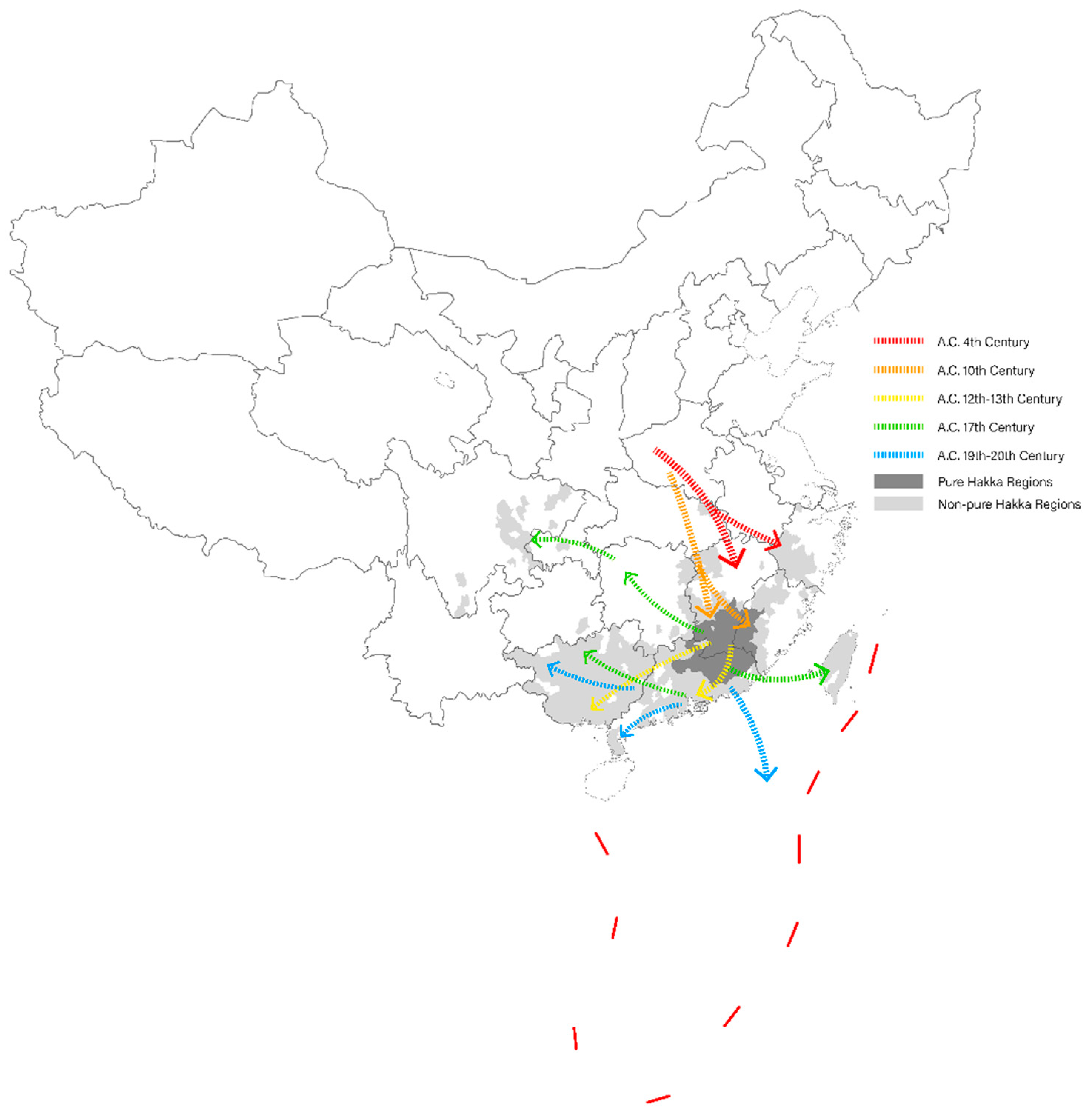
2]. Because of wars and famines, the Hakkas migrated from the Central Plains in northern China to the south over several centuries (
Figure 1). During the migration, the identity of the outsiders caused the Hakka ancestors to face unfamiliar natural and cultural environments, as well as the hostility of the indigenous wherever they went, making conflicts unavoidable. It strengthened the cohesion and introversion of the Hakkas and made them consistently maintain the lifestyle and cultural values that they retained from the Central Plains. They established their tight-knit communities and maintained a strong sense of unity and solidarity within their group, and this allowed them to largely preserve their cultural traditions and values while adapting to the new environment. Nowadays, the Hakkas are widely distributed in southern China with the mountainous border area of Guangdong, Fujian, and Jiangxi provinces as the centre [
3]. It is broadly accepted that different cultural traits are decisive in shaping various building forms [
4,
5]. The Hakkas also created unique dwellings based on their unusual origins and distinctive culture, with Tulous and Weilong Houses being the most important representative types.
Tulou:
The term Tulou (土楼) literally consists of “earth” (土 Tu) and “building” (楼 Lou) in Chinese, meaning the building made of rammed earth (
Figure 2). Although this construction technique is widely implemented in Chinese traditional dwellings, Tulou specifically refers to the multistory residential buildings using rammed earth as the predominant material, located in the mountainous areas of southwestern Fujian, which are designed to accommodate large families with outstanding defensibility [
6]. Nowadays, approximately 3000 Tulous are still existing, among which 45 were listed on the UNESCO World Heritage List in 2008 [
7]. These Tulous come in both circular and square shapes, with a larger number of square-shaped Tulous still in existence. However, circular Tulous are more well known and representative, with more famous examples such as Zhencheng Building (振成楼) and Er-Yi Building (二宜楼) being circular. Both the Hakka and Hoklo (福佬人) (Hoklo is another subgroup of Han Chinese just like Hakka, they mainly distribute in the coastal region in southeast China, especially Fujian Province.) have the tradition of building Tulous, and while the Tulous built by the two groups may share similar exteriors, however, there are substantial differences in spatial typology, constructional logic, and sociocultural connotation between them. First, for the Hoklo Tulous, the central courtyards are mostly void of daily functions such as sun curing, livestock feeding, and festival celebrating, while the Hakkas built their ancestral halls right in the very centre of their Tulous [
6]. It is the result of Hakkas, the guest-group migrated from the Central Plains, still maintaining traditional etiquettes of Confucianism with a strong emphasis on the respect and commemoration of their ancestors. Moreover, since the Tulou is a large collective accommodation built by the whole clan, it is to be divided into separate rooms for individual families. Most of the Hoklo Tulous are separated into quite independent multistory sectors by rammed earth load-bearing walls, which is called a sector-type or unit-type layout. For the Tulous of Hakkas, the peripheral residential sections are usually divided by a wooden framework with adobe partitions and with an annular corridor on each floor stringing up the individual rooms, which is called a corridor-type layout or gallery-type layout [
8].
Weilong House:
The term Weilong House (围龙屋), alias Encircling House or Wai Lung House, literally meaning encircling (围 Wei) dragon (龙 Long) house (屋 Wu), is one of the Hakka traditional dwellings that is mainly distributed in northeast Guangdong (
Figure 3). It is a congregate dwelling typology housing a whole clan and designed with the guidance of the Chinese traditional geomantic omen, alias Feng’shui (风水). Weilong Houses are usually located at the foot of a hill with superior geomantic conditions. The main structure of a Weilong House exhibits a concentric “∩”-shape, with halls called Tang’wu (堂屋) at the geometric centre. Tang’wu is derived from the multi-courtyard structure of the Central Plains’ architectural convention, with larger ones consisting of upper, middle, and lower halls, while smaller ones possess only upper and lower halls. The upper hall is the core ritual space for worshipping ancestors and other gods, and family-related ceremonies such as weddings and funerals are held here. The middle and lower halls serve as gathering and meeting areas. There is also the concept of the human body as a microcosm. On the left and right sides of the halls are multiple traverse wings called Heng’wu (横屋), which take the human body as the model, circularly enclosing the halls, and stretching forward as if to greet people [
9]. At the rear of the halls and Heng’wu are multiple concentric semicircular rings called Wei’wu (围屋). Both the wings and rings are evenly divided into sized rooms for residential use. Between the Wei’wu and the central halls, there is a semicircular outdoor space called Hua’tai (化胎). It is slightly bumped as a metaphor for a mother’s womb nurturing a foetus, representing an important manifestation of Hakkas’ fertility worship [
10]. Moreover, Feng’shui theory emphasises the harmony of Yin’yang (阴阳) for a balanced world, reflecting naive binary dialectic thoughts. Therefore, a half-moon-shaped pond is placed in the front of Weilong House, forming a circle with the semicircular Hua’tai, symbolising the unity of Yin’yang, which is regarded as auspicious in traditional Chinese society [
11]. In addition to the ritual function, the pond also serves practical purposes, such as water supply for living and agriculture, local microclimate regulation, and fire extinction. Between the house and the pond, there is an open forecourt called He’ping (禾坪), mainly used for sun curing and serving as a venue for ceremonial activities such as dragon and lion dances, as well as banquets.
According to the introduction above, there are substantial differences in architectural formation and cultural connotation of Tulous and Weilong Houses. In the field of architectural research, Hakka traditional dwellings have always been an important topic in the study of traditional Chinese dwellings. In the past, a large amount of research mainly focused on the history and origins of traditional Hakka dwellings, with a particular interest in the historical and sociocultural determinants that shaped the unique architectural morphology of Tulous and Weilong Houses, or from the perspective of architectural conservation and restoration, to study the continuation and renewal of traditional Hakka dwellings in contemporary times, using research methods mainly involving documentary survey, recording, and mapping. These studies include in-depth exploration and documentation of individual types of traditional Hakka dwellings, such as Huang Hanmin’s “Fujian Tulou” [
6] and Chen Zhihua’s “Three Villages in Meixian” [
12], as well as other research that classifies and introduces Hakka dwellings based on ethnic and regional differences, such as Wu Qingzhou’s “Architectural Culture of Hakka, China” [
10] and Lu Yuanding’s “Guangdong Dwellings” [
13]. It is common that the conventional studies of traditional dwellings have been heavily weighted in description, summarisation, and explanation. However, such descriptive approaches have difficulty in quantitively evaluating the spatial attributes and grasping the spatial patterns. Space syntax, on the other hand, starts with the spatial configuration, which is the spatial relationship taking account of all other relations and takes a systematological perspective to analyse the complex relationships among spaces at different scales and the fundamental mechanism that shapes these relationships. It provides a rigid analytical method of investigating how the spatial layout of the built environment has an impact on social behaving and patterning. In recent years, it has been widely applied in the studies on traditional dwellings. Therefore, this paper chooses space syntax as a tool to compare the latent spatial patterns and the configurations among different types of Hakka dwellings and correlate them with the heterogeneity of Hakka communities and cultures in their respective regions.
In the next section, this paper takes Zhencheng Building (振成楼), Huaiyuan Building (怀远楼), and Zhenfu Building (振福楼) as the case studies of Tulous, and Wengongci (温公祠), Lingxia Hall (岭下堂), and Dexin Hall (德馨堂) as the case studies of Weilong Houses, and launches a quantitative analysis on the spatial configuration of these samples basing on the methodology of Space Syntax and discuss the result in relation with socio-cultural factors of Hakkas.
3. Results
The analysis of visual integration indicates that for all the Tulou samples, the central courtyards possess the highest degree of integration (
Figure 12). The measures gradually decrease from the central courtyard through the radial hallways to the surrounding living spaces, presenting a clear spatial structure of centralisation and radiation. This structure is conducive to gathering clan members in the central courtyard, which is located in front of the ancestral hall and enhances the dominant effect of the main hall in the whole spatial structure. The difference is the distribution of the space with secondary high integration in the peripheral courtyards of each Tulou due to different spatial connections between the central courtyard and the peripheral courtyard. However, these spaces are highly integrated with the central area, and their degree of integration depends on how close they are integrated with the central courtyard and ancestral hall. The facilities such as kitchens, bathrooms, and pigsties located in the inner ring, as well as the living spaces in the outer ring, exhibit the lowest degree of integration. Overall, the public spaces present a prominent position in the overall spatial structure, while the private spaces of individual households are located at the marginal position.
In terms of agent analysis, the graph illustrates that the central courtyard and main hall are the areas with the highest human traffic, followed by the hallways connected to them and radiating outwards (
Figure 13). The living courtyards between the inner and outer rings, which serve as the traffic space connecting independent rooms, occupy the tertiary high degree, while the individual rooms and ancillary facilities are the spaces with the lowest human traffic. A tertiary structure of core (central courtyard and ancestral hall)–axis (radial hallways)–ring (circular courtyard) can be observed in all the cases. However, the circular courtyard of the Zhencheng Building is divided into four sectors by the front halls and hallways leading to the core area, so these radial axial-spaces draw in a higher flow of people than the circular courtyard. The circular courtyard of Huaiyuan Building is more integrated because it is only divided into two relatively complete semicircular spaces by the axial-spaces linking to the core area, resulting in two high-integration spots that are connected to the core area in the middle of the semicircular courtyards, making these living courtyards more crowded. Zhenfu Building has an unobstructed central axial-space from the entrance straight to the rear hall, as the north side of the middle hall is open to the rear hall with no partition. Therefore, the integration and human movement of the central axial-space are prominent in the overall spatial structure of the building. This is because Zhenfu Building weakens the function of the middle hall and emphasises the sacredness of the rear ancestral hall, cancelling the background wall of the middle hall and making the central axial-space lead directly to the ancestral hall at the end of the axis.
With regard to Weilong Houses, the highest degree of integration is mainly concentrated on the He’ping (the forecourt) outside the main building, especially at the nodes where the lanes among the traverse wings intersect the forecourt (
Figure 14). It is similar to the distribution of high integration at road intersections in a spatial configuration of an urban network and tends towards a gridification spatial structure. The second highest degree of integration is found in the area where the Hua’tai is located, because this area is relatively open in the overall structure and being in this location allows for a view of more space. The vertical lanes that connect each individual room possess the third highest value of integration. When encountering situations where there are horizontal passages traverse the wings, the intersection of the lanes and the passages can also achieve locally high integration, which is highly similar to the urban gridification structure. The configurational values of the halls are only higher than those of individual rooms, indicating that although the main halls are located at the geometric centre of the entire building, it is not prominent in the overall spatial configuration. The ancestral hall being of a relatively deep step-depth demonstrates that the ritual space of the Weilong House is not as easy to access as that of the Tulou and the living space and the ritual space of the Weilong community are separated. According to the degree of integration, the spatial structure of Weilong Houses is in the following order: The forecourt–Hua’tai–lanes–halls–rooms. The positioning of the main halls in the spatial structure and the distribution pattern of integration of Weilong Houses are substantially different from those of Tulous.
According to the graph of agent analysis, the forecourt and Hua’tai are the areas that draw in the highest foot traffic; it is consistent with the fact that the forecourt is an important public activity space for the community (
Figure 15). The lanes that connect individual rooms are the next, indicating that these are important spatial circulations, and the gridification spatial structure is more intuitively reflected here. The people gathering effect of the halls is not significant, which is inconsistent with their prominent cultural significance. It is worth noting that the Hua’tai, as a ritual spatial element of fertility worship in Hakka culture, is generally not allowed to be entered or used for daily purposes. However, the Hakkas devote a lot of space to creating Hua’tai, giving it highly attractive spatial attributes to human traffic. Such a dual characteristic (non-accessible but crowd-appealing) largely strengthens the cultural value of Hua’tai and highlights the important positioning of the fertility worship in Hakka culture. However, this cannot be used as evidence for comparing the cultural and ritual values of Hua’tai and the ancestral halls, but only illustrates that in addition to the ancestral halls, the spatial system of Weilong Houses also includes spatial elements that are significant in cultural value and spatial attributes, relative to the prominent positioning of the ancestral hall in the unicentric spatial structure of Tulous.
In order to measure how easy/difficult for people to infer the global structure from the local layout and hints, the correlation coefficient of connectivity and integration, termed as the intelligibility, is chosen to make an analysis of the attributes of spatial recognition. Because for any a given space, if it has more connectivities to its neighourhood spaces and meanwhile is closer to all the others, it means that the whole structure relating to this space is clearer and easier for people to recognise and understand from a point of view of this space. Intelligibility is one of the tools that investigates the correlation between the local (connectivity) and the global (integration). Overall, the measure of intelligibility of Tulous is significantly higher than that of Weilong Houses (
Table 1). The lowest intelligibility in Tulou cases is found in Zhenfu Building, which is 0.875, higher than the highest intelligibility in the cases of Weilong Houses, which is 0.847 in Dexin Hall. This means that the spatial structure of Tulous is clearer, and it is easier for people to recognise their spatial position when they are in it. From the scatter plot (
Figure 16), the connectivity and visual integration of the spatial elements in Tulous present a positive linear regression, indicating a fine integration interface, which is a benign relation between different scales of movement and also a manifestation of the overall integration and close combination of different parts in the spatial system. In the spatial configuration of Tulous, spaces with high integration are mostly the spaces with high connectivity, and most of these highly recognisable spaces are located in the central courtyard and main halls, which means that people can better recognise their position in the overall spatial system when they are in the main space of Tulous. In contrast, the scatter plot of Weilong Houses presents a relatively discrete linear regression between connectivity and integration, and two different linear regressions of different slopes corresponding to the distribution of residential and public spaces. This means that the spatial connection between residential and public spaces is relatively weak, and they establish respective own spatial systems. Spaces in Weilong Houses with a high correlation coefficient of integration and connectivity are mainly distributed in the peripheral residential areas, where the connectivity and integration of the space are both relatively low, consistent with their positioning as private living spaces in the overall spatial structure. The points representing other spaces in Weilong Houses are more scattered, indicating that the intelligibility of these more important spaces is relatively low, which means it is not easy for people to realise they are in the core area when they are in these spaces. This result demonstrates that in Weilong Houses, people in the peripheral and private residential spaces can recognise their position in the relatively marginal and private areas of the entire space, but in more important spaces, such as the halls, it is not easy to recognise their position in the more important areas of the entire space.
4. Discussion
As an embodiment of socioculture and collective perception, dwellings are concrete materials for studying the sociocultural characteristics of certain groups and their relations with the external world. As both the representative dwellings of Hakkas, Tulous and Weilong Houses are large collective dwellings built by the joint effort of the whole clan, their spatial structures reflect the social structure of the clan and the relationship between the community and the natural and sociocultural environment to some extent. Tulous are considered a product of disorder in governance and ethnic conflicts in the peripheral areas of the Hakka region. This mountainous area around the Hoklo and Hakka border is the area where Tulous emerged, mostly because of the conflicts between Hakka and Hoklo people [
23]. Due to differences in cultural identities and competing for habitat and resources, they were in constant conflict and defensibility was the highest priority of their dwellings. Thus, the fortress-like Tulou was not exclusive to the Hakkas; the Hoklo people also built and inhabited Tulous. Conversely, Weilong House mainly appeared in the heartland of the Hakka region. In history, Meizhou has long been the political and economic centre of eastern Guangdong, with the major ethnicity being Hakka. The strong administrative control and the stable social order also made Meizhou the cultural centre of Confucianism since the Ming Dynasty; thus, Hakka residents laid more emphasis on comfort and cultural taste instead of defensive function in the construction of dwellings. Overall, the emergence of Tulous with high defensibility is the result of harsh natural and sociocultural contexts in the peripheral areas of the Hakka region, while Weilong House is a concrete manifestation of this subgroup of Han in the process of settling in the Guangdong–Fujian–Jiangxi border area as the heartland of Hakka [
24].
The spatial structure of Tulou presents significant centrality and radiality. The highly integrated space is mainly concentrated in the central courtyard and hall, and then the axial-space connected to the core area. Such spatial structures are conducive to gathering clan members in the core area, reflecting individuals’ high attachment to the clan. However, it consequently means that the highly integrated space is more distant from the external world. Based on the calculation logic of integration, Bill Hillier proposed the “paradox of centrality” in “Space is a Machine” which states that in basic geometric forms, the circle is theoretically of highest integration, with the highest integrated area in the centre, gradually declining to the lowest at the edge. In actual space, the higher integration of a layout, the closer it is to a circle, and the internal spatial area with the highest integration will be more isolated from the external world. In other words, maximising internal integration also maximises external segregation, which is the “paradox of centrality” [
14]. The layout of the Tulou clearly is a typical manifestation of the paradox of centrality. The high integration of its circular layout can tightly consolidate all internal spaces, but it also means that it is highly isolated from the external world. This is an ideal spatial pattern that meets the functional requirements of the Hakkas’ solidarity and defence against external threats. However, this is not a favourable strategy for other human habitats. For example, in urban spaces, the paradox of centrality needs to be resolved through certain spatial strategies. Hillier’s answer to this is a structured grid that is one in which integration and intelligibility are arranged in a pattern of some kind, which supports functionality and intelligibility. Essentially, lines and areas are prioritised for integration and intelligibility to varying degrees to create a system of differentiation which is the so-called structure [
14]. For a general human habitat that does not raise the special requirements for enclosure and defensibility like Hakka dwellings, internal integration and integration with the external world are both necessary. A structured grid is the intermediate space pattern, as it has the potential to eliminate boundaries and hierarchy, making the space more permeable, homogeneous, and egalitarian.
Although the Weilong House still presents a crescent-shaped encircling form, its spatial configuration tends to be a structured grid. The ceremonial spaces and the living spaces exhibit a trend of “zoning”, and the living spaces possess higher configurational values than the ceremonial spaces. The spaces with high integration are mainly located on the forecourt outside the house, and the halls do not occupy a highly important positioning in the spatial configuration, which is inconsistent with its cultural core positioning in the Weilong House. Previous studies on the Weilong House focused on the relationship between the concept of clan-based etiquette system and the axisymmetric layout of hierarchical spatial pattern, to discuss the continuous influence of the Central Plains traditional culture on the Hakkas, and emphasised the core positioning and ritual significance of the halls in the spatial structure of Weilong Houses, while the forecourt was often treated as an ancillary functional space. However, the graphical presentations of configurational indexes show that the area with the highest integration is separated from the ancestral hall and located in the forecourts, which means that the forecourts are the most intuitive position for observing and identifying the overall spatial structure of the Weilong House from a human perspective. This reflects that the spatial value of functionality outweighs that of rituality in the life of Hakka residents in Weilong House. For the Weilong House, a large number of spatial elements exhibit medium connectivity but low integration, which means that there are adequate spaces directly connected to a particular space, making it easily accessible to adjacent spaces, although it is located on the periphery of the overall spatial structure. This peripherality implies privacy, which is an important value in residential spaces to some extent. This spatial phenomenon presented by the Weilong House is worth noting because connectivity and integration in the spatial configuration are generally in positive correlation, but the Weilong House shows a relatively discrete state or even a local negative correlation. This phenomenon was also observed in previous urban studies, and it is considered a form of “zoning”, meaning that different groups of people can “quietly” access the target space. This is consistent with the phenomena we observed during field research. The ancestral hall and central courtyard of the Tulou not only serve important ceremonial functions but also become gathering places for elderly residents and children to chat and play on regular days. The spatial configuration determines that the ancestral hall and central courtyard maintain their functions as both ceremonial centre and daily living centre. On the other hand, in the Weilong House, the halls only turn lively gatherings of clan members during important festivals such as Chinese New Year, weddings, and childbirth celebrations. On regular days, it appears rather quiet, with some samples even being dilapidated and rarely visited by residents. Daily conversations and games often take place along the lanes and shaded areas of He’ping. This reflects the decentralisation and zoning effects presented by the spatial configuration of the Weilong House. Moreover, in conversations with local people, their recognition of the position of the main halls is directional and topological. They perceive and evaluate it regarding the location of their own rooms, often using terms like “left” and “right” to describe the location of the main halls. Distance is described not in terms of actual physical distance but through “turns”, such as “turn left and then turn right to get there”. This transformation of geometric physical distance into a topological distance that humans can better perceive is actually a core concept of space syntax. Therefore, to some extent, the results of syntactical analysis on these two types can intuitively support and deliver observations in anthropological local chronicles.
The different spatial structures presented by Tulous and Weilong Houses suggest the different internal social structures and the relations to the external world of Hakka clans they respectively shelter. Tulou residents remain confined within their communities, tightly united at the core of clan, and rely on internal cooperation as the base of their daily life and continuity, staying in relative isolation or “suspension” from the external world. The residents of Weilong Houses, on the other hand, while retaining respect for the clan, present a higher degree of self-reliant status and more participation in the external world. The cultural identity of Hakkas is actually prominent in both “sojourning” (为客, being a guest) and “settling” (有家, having a home). On one hand, the origin and history of migration have made the cultural identity of Hakkas as “guests” profoundly ingrained in others’ gaze. On the other hand, they are also profoundly anchoring to the Guangdong–Fujian–Jiangxi border area, where they have created a unique regional culture and architecture. When talking about Hakkas, people will usually think of places such as Fujian and Guangdong. The modern sense of Hakka culture has deeply taken root in this land. Therefore, “Landed” is a state similar to “self-being”, which does not involve mutual definition with specific external objects and presents a sense of abstraction, apriority, and conceptual. “Rooted”, on the other hand, is a more “self-becoming” state that must be related to a specific place and defined in mutual relation with specific external objects and presents a sense of concreteness, posteriority, and realism. Therefore, from the characteristics of architectural morphology and spatial configuration, Tulous are more the reflection of the inhabitation pattern of Hakkas’ “being guests” landed on the Guangdong–Fujian–Jiangxi border area, while Weilong Houses are more suited to their hosts’ being rooted and “having a home” status in this land. Before reviewing the findings, it is important to reiterate the contributions and limitations of this research:
Contribution:
Proposing a comparative study on the spatial configuration of Tulous and Weilong Houses in relation to sociocultural factors
Reinterpreting the commonalities and differences between Tulous and Weilong Houses through quantitative analysis of space syntax
Detecting decentralisation and gridification in the spatial structure of Weilong Houses in comparison to Tulous
Addressing the relations between spatial configuration and sociocultural characteristics of Tulous and Weilong Houses
Proposing the different community existence paradigms of “landed” and “rooted” as Tulou Hakkas and Weilong House Hakkas respectively inhabiting the periphery and heartland of the Hakka region.
Limitation:
The methods in this paper can only be used to evaluate the topological properties of the architectural layout; thus, more in-depth ethnographic research on local customs and practices can be combined to obtain a better understanding of the differences in social structure and neighbourly relationships between the communities in Tulous and Weilong Houses.
Further case studies or more syntactical measures can contribute to better demonstrating the cultural ecology strategies of ‘Landed’ for Hakkas in Tulous and ‘Rooted’ for Hakkas in Weilong Houses.
5. Conclusions
Hakkas, as an ethnic group with a unique origin and culture, their cultural characteristics, and the cultural manifestation in Hakka traditional dwellings have been focal points of research in disciplines such as anthropology and architecture. The most common finding is that the core positioning of the ancestral hall is the fundamental characteristic and key evidence of Hakkas’ history and cultural relation to central China; the architectural morphology of the ancestral hall and other ritual spaces are derived from the courtyard house, whose spatial sequence and system reflect the influence of Confucianism etiquette and ritual concepts and Hakkas’ value of ancestor worship. Believing that the ancestral hall and other ritual spaces are the core components of the overall spatial structure. However, previous research on Hakka traditional dwellings mostly focused on in-depth research of a single typology, with limited comparative study between different typologies. The limited comparative research was also confined to documentary description of architectural morphology, lacking research on the spatial–cultural relations between different typologies. And there is overreliance on documentary recording and qualitative analysis regarding methods, which can lead to a gap between grand narration and personal perception. As a humanistic quantitative analysis methodology, space syntax can help us analyse the inherent rules of spatial configuration and construct a research perspective that relates spatial structure and social organisation and human behaviour. It considers that spatial structuring is the nature of social organisation and a way to achieve social objects, thus linking anthropology and architecture. The social relationships are solidified and materialised in the spatial patterns of Tulous and Weilong Houses. This wealth of social and symbolic information could be decoded by reading and comparing their spatial configurations [
25].
Through the quantitative tools of space syntax, the analysis of the spatial configuration of Tulous and Weilong Houses reveals substantial differences in social–spatial adaptability. Located in the peripheral area of the Hakka region and constantly interacting with other ethnic groups, Tulous retain the spatial form from the early settlement of Hakkas in the mountainous Guangdong–Fujian–Jiangxi border area. Sociality and collectivity are more prominent in the spatial structure, and the ancestral hall of Tulous is both located in the geometric centre and possesses a higher spatial structural value, unceasingly representing the spiritual and living centres of Tulou residents. Functional and ceremonial spaces are still combined, and the highly centripetal structure is more conducive to maintaining individual attachment to the clan, which in terms of architectural morphology and social structure exhibit a sense of “hovering” in the natural and cultural contextual environment. In contrast, the Weilong House, located in the heartland of the Hakka region, is more suitable as residence for social individuals. Although the ancestral hall of Weilong Houses is still in the geometric centre, it does not exhibit the highest spatial structural value; the overall spatial structure presents a structured grid configuration. While still retaining recognition and respect for Confucianism and clan concepts, the spatial structure of Weilong Houses highlights the secular function and presents a “growing” state in the local natural and cultural environment.
Space has a disciplinary effect on human behaviour [
26]; the monocentric structure of Tulous tends to keep its residents in a state of “being guests” landed on western Fujian, which is reflected in the closed and inward nature of the architectural morphology of Tulous and the lifestyle regulated by the corresponding spatial structure. The gridded structure of Weilong Houses is more conducive to residents stepping outward, settling down, and taking root in eastern Guangdong. Not only is the architectural layout more open, but the individual family life is more independent and the secular spatial value exceeds the ceremonial spatial value. This corresponds to the Hakka communities’ distribution characteristics of “Centre–Periphery” presented by Tulous and Weilong Houses [
27], reflecting two different relations of “landed” and “rooted” to the external world as Hakkas migrate and settle in the Guangdong–Fujian–Jiangxi border area. “Landed” and “rooted” are not just metaphors for the architectural morphology of Tulous and Weilong Houses, but also the paradigm of the existence how the two groups of people with the same identity of Hakkas inhabiting their different sociocultural soils. “Landed” and “rooted” also embody the shaping and expression of the dualism of “being a guest” and “having a home” in the cultural identity of Hakkas. This study can expand the research perspective on Hakka dwellings in the cultural concept of “Great Hakka” by linking the differences in spatial structure to the differences in sociocultural structures of Hakka communities in various regions, and further investigate the potential cultural–spatial genes underlying the generation and development of various typologies of Hakka dwellings in different regions.


