Systematic Review

Advanced Digital Technologies in the Post-Disaster Reconstruction Process—A Review Leveraging Small Language Models

1
Department of Civil Engineering and Architecture, Tallinn University of Technology, 19086 Tallinn, Estonia
2
Independent Researcher, Dubai, United Arab Emirates
*
Author to whom correspondence should be addressed.
Buildings 2024, 14(11), 3367; https://doi.org/10.3390/buildings14113367
Submission received: 26 September 2024 / Revised: 13 October 2024 / Accepted: 16 October 2024 / Published: 24 October 2024

Abstract

:
Post-disaster reconstruction of the built environment represents a key global challenge that looks set to remain for the foreseeable future, but it also offers significant implications for the future sustainability and resilience of the built environment. The purpose of this research is to explore the current applications of advanced digital/Industry 4.0 technologies in the post-disaster reconstruction (PDR) process with a view to improving its effectiveness and efficiency and the sustainability and resilience of the built environment. The extant research literature from the Scopus database on built environment reconstruction is identified and described. In a novel literature review approach, small language models are used for the classification and filtering of technology-related articles. A qualitative content analysis is then carried out to understand the extent to which Industry 4.0 technologies are applied in current reconstruction practice, mapping their applications to specific phases of the PDR process and identifying dominant technologies and key trends in technology deployment. The study reveals a rapidly evolving landscape of technological innovation with transformative potential in enhancing the efficiency, effectiveness, and sustainability of rebuilding efforts, with dominant technologies including GIS, remote sensing, AI, and BIM. Key trends include increasing automation and data-driven decision-making, integration of multiple Industry 4.0/digital technologies, and a growing emphasis on incorporating community needs and local knowledge into reconstruction plans. The study highlights the need for future research to address key challenges, such as developing interoperable platforms, addressing the ethical implications of using AI and big data, and exploring the contribution of Industry 4.0/digital technologies to sustainable reconstruction practices.

1. Introduction

1.1. Context

In the wake of disasters, the need for reconstruction of the built environment often exceeds the available resources to carry it out [1]. An example of the scale of this problem is the ongoing conflict in Gaza, which had, by the end of January 2024, resulted in an estimated US$18.5bn in damage to buildings and infrastructure (equivalent to 97% of the GDP of both Gaza and the West Bank for 2022), the majority of which (US$13.3bn) is damage to housing [2]. Similarly, the estimate to December 2023 of the direct damage to Ukraine’s built environment is US$152bn (or approximately 65% of Ukraine’s 2021 pre-invasion GDP), again with housing (estimated damage US$56bn) making up the largest proportion (37%) of this total [3]. In addition to conflicts, the total damage from disasters triggered by natural and technological hazards (excluding conflicts) for the year 2023 alone is estimated to be US$202.7bn according to the EM-DAT database [4], and it is reasonable to assume that much of this will have been assessed from damage to built assets. With worldwide trends, including rapid urbanization, increasing geopolitical friction and competition, as well as environmental degradation and climate change [5], the demand for post-disaster reconstruction will remain a key global challenge for the foreseeable future. These trends are interrelated and often mutually compounding in their effects. For example, the European Strategy and Policy Analysis System’s Global Trends to 2040 notes that: “the ‘mega transitions’ such as the changing climate and new technologies will push geopolitics into new territory” [5].
Reconstruction may, however, present opportunities for positively influencing the future built environment’s (and society’s) sustainability and its resilience to future catastrophes. Since approximately 40% of Green House Gas (GHG) emissions are associated with the heating, cooling, lighting, etc., of buildings [6], a radical reconception of the future built environment is central to addressing climate change and the adoption of a regenerative sustainability paradigm in reconstruction can help redress the dysfunctional human-nature relationship to restore and regenerate the global socio-ecological system [7]. Similarly, reconstruction offers opportunities to develop a more resilient built environment. For example, the “build back better” paradigm advocates the incorporation of long-term disaster mitigation measures and the inclusion of disaster-hit communities in reconstruction processes to facilitate their livelihood support and long-term resilience [8].
In addition to its influence on geopolitics, technological change offers many opportunities to improve the speed, efficiency, resilience, and sustainability of the reconstruction process. The adoption and integration of advanced digital technologies, particularly those associated with the Fourth Industrial Revolution, enable both improved industrial productivity and reduced negative impacts [9].
This article leverages a literature review approach enhanced by small language models (SLMs). Traditional review methodologies rely on keyword searches and manual inclusion/exclusion of publications based on metadata [10,11]. This approach is labor-intensive, often requiring multiple reviewers. Recent advances in Large Language Model (LLM) reasoning capabilities [12] offer a more expedited and efficient alternative for selecting papers based on predefined eligibility criteria. Moreover, the emergence of open-source models such as Meta Llama 3, Google Gemma2, Mistral AI, and Microsoft Phi3 has made these tools accessible to a wider research community. While LLMs excel in various reasoning tasks, their smaller counterparts, aptly termed “small language models” (SLMs), provide comparable performance for specific tasks with reduced system requirements, making their capabilities accessible to a broader audience [13,14].
To establish an initial list of technologies, we drew on recent publications involving Industry 4.0 and digital technologies [15,16]. The initial list is presented in Table 1. It is worth noting that this list serves as a starting point and is intentionally kept flexible to accommodate updates based on the findings of our detailed study of the papers.

1.2. State of the Art

This review article distinguishes itself from previous research by focusing specifically on the applications of Industry 4.0 technologies in post-disaster reconstruction (PDR), a critical yet often overlooked aspect of disaster management. While many existing reviews have explored the broader landscape of technology applications in disaster management, they have lacked a dedicated and in-depth analysis of how Industry 4.0 is transforming PDR practices. Most recent review papers tend to focus on one or a set of technologies within different domains of disaster management.
Artificial intelligence (AI) has been a common focus in distinct phases of disaster management. Ref. [17] explored the use of AI in urban ecosystem-based disaster risk reduction (Eco-DRR), highlighting its potential for building resilience and sustainable cities. However, its emphasis on Eco-DRR, which primarily leverages natural ecosystems for disaster mitigation, distinguishes it from PDR. Ref. [18] provided a comprehensive overview of artificial neural networks (ANNs) in disaster management, analyzing various architectures and their applications across different disaster types and phases. However, its primary focus was on the mitigation and preparedness phases, with limited exploration of the response and recovery phases where PDR is most relevant. Similarly, ref. [19], while investigating AI in natural disaster management through topic modeling, primarily focused on identifying broad research trends without delving into the specific applications of AI within PDR. In a similar approach, ref. [20] focused on the application of deep learning (DL) in disaster management and shared some relevance to the research on Industry 4.0 technologies in PDR. It provided a comprehensive overview of deep learning models, including convolutional neural networks (CNNs) and long short-term memory (LSTM), and their potential applications across all four phases of disaster management, including recovery. The paper highlighted use cases relevant to PDR, such as using DL for damage assessment and using social media analysis for understanding community needs and developing educational systems for preparedness. However, it lacked a dedicated analysis of how these models could be integrated into a comprehensive Industry 4.0 framework for PDR.
In addition, there have been reviews focusing on a broader set of technologies but within a specific scope of application. Ref. [21], explored the potential of disruptive technologies (IoT, AI, Big Data) in disaster risk management, primarily focusing on their integration within smart city infrastructure for enhancing overall disaster preparedness, response, and recovery. The paper acknowledged the relevance of these technologies for PDR, showcasing examples like using drones for damage assessment and AI for resource allocation. However, it lacks a dedicated and in-depth analysis of their specific applications within the reconstruction phase.
Habibi et al. [16] offered a valuable overview of Industry 4.0 technologies in disaster risk management and infrastructure resilience. The authors identified six dominant technology clusters, including AI, big data, IoT, prefabrication, robotics, and cyber-physical systems, and discussed their potential applications across different disaster management phases. However, the review primarily provided a high-level overview of these technologies and their potential benefits without delving into specific applications and challenges within PDR.
Yu, M et al. [22] explored the transformative role of big data in natural disaster management, encompassing various data sources and technologies across different disaster management phases. While the paper highlighted the potential benefits of big data and associated technologies for improving various aspects of disaster management, including damage assessment, resource allocation, and recovery monitoring, it did not provide a focused analysis of how big data analytics can be specifically applied to enhance PDR processes.
The review presented in this paper examines the evolving application of Industry 4.0 technologies in the PDR process and explores trends in their individual utilization. In the following section, the methodology for the literature review incorporating the assistance of SLMs is set out. A detailed analysis of the technology-related subset mapping the Industry 4.0 technologies and their applications to specific phases of the PDR process follows. Conclusions are drawn regarding dominant technologies, key trends in technology deployment, and recommendations for future research.

2. Methodology

This review examines the evolving application of Industry 4.0 technologies in post-disaster reconstruction and explores trends in their individual utilization. The initial search, employing the string (TITLE-ABS-KEY ((reconstruct* OR rebuild*) AND (“built environment” OR hous* OR infrastructure) AND (conflict OR war OR disaster OR crisis))), yielded 4203 papers from the Scopus database. Scopus was selected for its status as a leading curated database of scientific literature, known for its rigorous content selection process, ensuring data quality [23]. The database’s accessibility of metadata, including citations, bibliographies, abstracts, keywords, funding sources, and more, in CSV format enabled convenient analysis. SLMs were then used to select relevant (Industry 4.0 technology-related) papers. Figure 1 shows the search and filtering process.
Prompt engineering is crucial for optimizing the performance of language models in paper selection based on specific criteria. However, several factors can influence model accuracy, including ambiguity in prompts, bias reinforcement, overfitting, and lack of context [26]. In this study, we aimed to minimize false negatives, ensuring that relevant papers were not inadvertently excluded. While fine-tuning can enhance performance, our experimental data with much larger models led us to focus on prompt engineering. We began by randomly selecting 100 papers from Scopus using the Python random module on the database of 4203 paper metadata, ensuring a mix of relevant and non-relevant papers. The reason for selecting this number was to keep a balance between accuracy as well as time for prompt tuning, as different abstracts were checked multiple times to find which prompts considered which elements of the abstract to derive their conclusion.
These abstracts were manually reviewed for relevance and marked “Yes” or “No”. This subset was used to compare the accuracy of smaller language models (Microsoft Phi 3:14b, Meta Llama 3:8b, and Google Gemma 2:9b) with leading large LMs like ChatGPT 4.0, Llama 3:70b, and Mistral Large through their APIs. Interestingly, while larger models contained more knowledge and were expected to yield better results, the accuracy for true positives was similar across both smaller and larger models. However, larger models produced significantly more false positives, often inferring the use of digital technologies from abstracts where they were not explicitly stated. This observation, combined with the near 100% accuracy for true positives across even the smaller models, led us to conclude that “disaster management” as a topic was understood well enough by both small and large LMs to achieve high accuracy without fine-tuning.
Among these, the Google Gemma 2:9b model demonstrated the highest accuracy for the task. Therefore, the final prompts used for paper selection were derived from this tuning process with Google Gemma 2:9b and are detailed as follows:
Industry 4.0 Technologies—{3D modeling, 3D printing, 5G, artificial intelligence, big data and analytics, blockchain, building information modeling (BIM), augmented/virtual reality, autonomous robots, Internet of Things (IoT), mobile technology, RFID, sensors and actuators, simulation, chatbot, computer-aided design (CAD), digital twin, unmanned aerial vehicles (UAVs), geolocation/GNSS, geographical information systems (GIS), modular construction, predictive analysis, prefabrication, robots, and sensors}.
Relevance Assessment Prompt: “Analyze the following abstract and determine if it explicitly discusses the application of Industry 4.0 technologies {Industry 4.0} or other modern technologies in disaster management or post-disaster reconstruction. Answer only YES if there is a clear connection or NO if the connection is absent or ambiguous. Abstract: {abstract}”.
Relevance Evidence Prompt: “Examine this abstract and extract any sentences or phrases that directly mention or strongly imply the use of Industry 4.0 technologies {Industry 4.0} or other modern technologies in disaster management or post-disaster reconstruction. If no explicit mention exists, identify any parts suggesting potential applications of these technologies in disaster contexts. If no relevant content is found, state ‘No relevant content identified’. Abstract: {abstract}”.
Technology Identification Prompt: “List all Industry 4.0 technologies and other modern technologies mentioned in this abstract. Include but do not limit to: {Industry 4.0}. For each identified technology, provide a brief explanation of how it is applied or proposed to be used in the context of disaster management or post-disaster reconstruction. If no technologies are mentioned, state ‘No relevant technologies identified’. Abstract: {abstract}”.
The prompts were crafted based on the performance evaluation of the test dataset comprising 100 papers. The primary objective was to minimize false negatives, ensuring that no potentially relevant papers were excluded. This approach, while leading to increased false positives, was deemed acceptable as papers classified as “No” would be excluded from further review. The underlying rationale for this prompt design prioritized inclusivity over absolute precision, acknowledging that a higher tolerance for false positives was justifiable in this context. The logic underpinning the chosen prompts is as follows:
Relevance Assessment Prompt: The Python code forwarded the list mentioned above as {Industry 4.0 Technologies} to the language model. Apart from the PDR term, another term of disaster management was included because some of the papers that could be relevant to PDR were mentioned as a part of disaster management in some papers. Only “Yes” and “No” were asked in answer to separate the CSV file into one classified “Yes” and another classified “No” later using Python 3.10.
Relevance Evidence Prompt: It was observed that instructing the SLMs to identify the specific sentences underpinning their relevance classifications significantly improved accuracy. In certain instances, the initial prompt elicited a “Yes” classification, but upon being prompted to provide supporting evidence, the model revised its response to “No.” Furthermore, the SLMs were tasked with identifying relevant technologies based on their own interpretation of the abstracts, potentially expanding the list beyond the initial set of Industry 4.0 technologies.
Technology Identification Prompt: This prompt also had the sole purpose of ensuring the SLMs had a basis for classifying “Yes” and “No”.
The prompts were designed to maximize inclusivity, aiming to capture even marginally relevant abstracts for review while excluding everything else. The final prompts were refined through multiple iterations, carefully evaluating the impact of diverse instructions on both precision and recall.
The CSV files were processed using a Python code leveraging the Ollama [24] and Langchain [25] frameworks, enabling the local utilization of open-source language models. The testing configuration comprised an Intel i7 13,700 k CPU with 64 GB of RAM and an Nvidia 4090 GPU for running the models. The selected SLMs included Meta Llama 3:8b, Google Gemma 2:9b, and Microsoft Phi 3:14b, with “b” denoting the number of model parameters in billions. Downloads were conducted using the default Q4 quantization, as this precision level has been shown to deliver comparable performance to higher quantization levels in zero-shot learning scenarios [27].
To decide which SLM to choose for the detailed work, the 100 papers selected were manually marked relevant or “Yes” and not relevant or “No”. Then, using the finalized prompts, the three models were run on the metadata to classify the paper for each SLM. All the SLMs had a context window of 8 k, which means they could retain the context of the text up to 8000 tokens (words), which is more than sufficient for metadata analysis, though it is not suitable for processing entire papers.
Having found the Google Gemma2:9b model to be most appropriate for our purposes, we went forward with processing the whole dataset of 4203 papers’ abstracts. The total processing time on our test setup was 26,085.16 s (about 7 h). For further work, papers marked relevant or “Yes” were considered and classified based on the reconstruction phase as well as the digital technologies used. A sample of 1000 randomly selected papers, including those marked “No” or not relevant, were considered for the accuracy assessment of the model on the main literature review work. This step provided a more detailed analysis of the applicability of SLMs for such works.
After this step, a total of 545 papers were marked “Yes” by the Google gemma2:9b model. These were then manually checked for relevance, and 170 papers were removed from the initial list. Following that, all remaining papers were downloaded and further excluded based on language criteria (English), online availability, and actual use of the mentioned technologies in post-disaster reconstruction processes. A total of 235 papers were selected for full review after applying these filtering criteria.

3. Results and Discussion

3.1. Comparing Different SLMs

The 100 randomly selected papers were manually reviewed for relevance and marked “Yes” and “No”. After this, the three selected models were used to classify the models based on the above-mentioned prompts. Afterwards, the number of false positives and false negatives were counted to create the accuracy assessment matrix below (Table 2).
The following observations can be made from the results of the performance of each model.
Based on the performance metrics, each model presents distinct trade-offs. The Meta Llama3:8b emerges as the most balanced and reliable option, achieving the highest overall accuracy at 0.97 and offering a good compromise between precision and recall for both “Yes” and “No” classes. It demonstrates high precision (0.98) and recall (0.99) for the “No” class while maintaining respectable precision (0.75) and recall (0.60) for the “Yes” class. The Google Gemma2:9b model excels at ensuring no relevant “Yes” papers are missed, with perfect recall for the “Yes” class and high overall accuracy (0.96), though it struggles with precision for “Yes” classifications (0.56), indicating more false positives. The Microsoft Phi3:14b model, while achieving perfect precision for “No” class and perfect recall for “Yes” class, is hampered by very low precision (0.23) for “Yes” classifications and lower overall accuracy (0.83). It is also the slowest, taking 852.21 s to process 100 papers compared to 550–586 s for the other models. Time efficiency aside, Meta Llama3:8b stands out as the most practical choice when both precision and recall are important, while Gemma2:9b could be preferable when ensuring no relevant papers are missed is the priority, despite requiring more manual review of false positives. Another point in favor of Google Gemm2:9b was that it was the most recent model with the most recent knowledge cutoff date, hence for analysis of the entire corpus the Google Gemma 2:9b was used.

3.2. Technology in PDR—Research Articles per Year

The analysis of publication trends reveals a clear upward trajectory in the total number of PDR articles published over time, particularly since 2002 (Figure 2). This surge suggests a growing interest in the field of study, likely fueled by increasing awareness and the need for advancements in disaster management and reconstruction practices. While the total number of publications has increased significantly, the proportion of articles dedicated to digital technologies remains comparatively small. This observation suggests that digital technologies are still an emerging area within PDR research, potentially implying a gap in our understanding of their full potential and application in this field.
The analysis of technology adoption in PDR (Figure 3) reveals a clear hierarchy, with GIS holding a dominant position. This underscores GIS’s fundamental role in disaster management, facilitating mapping, spatial analysis, and monitoring impacted areas. Its extensive use highlights the established role of spatial data in understanding and responding to disasters. Remote sensing is ranked second, which is expected due to its integrated applications with both GIS and AI (Computer Vision).
Following these, Simulation is also a prominent technology used in simulating alternative disaster/recovery scenarios to support decision-making. Another prominent technology is artificial intelligence, which has major applications in computer vision, predictive analysis, 3D modeling when used as a visualization tool for situation awareness. UAVs are also used frequently for rapid data collection as well as creating 3D models using photogrammetry. Data analytics has also found use cases in analyzing and finding patterns in the vast amount of data generated during disaster events. Further technologies like BIM, GPS, sensors, and others are also emerging and finding use cases in the different phases of the reconstruction process.

3.3. Thematic Analysis

Applications of the Industry 4.0 technologies identified in the selected papers were categorized in relation to the PDR process. The PDR process was considered to comprise the following phases listed in chronological order of their typical occurrence:
1. Vulnerability and Risk Assessment: This foundational phase involves systematically analyzing potential hazards such as earthquakes, floods, etc., and assessing the susceptibility of communities, infrastructure, and the environment to these threats. It emphasizes the importance of proactive planning and understanding potential hazards and weaknesses before a disaster strikes.
2. Rapid Damage Assessment: Immediately following a disaster, rapid assessment is crucial. This involves quickly gauging the extent and severity of damage using readily available data and technologies like remote sensing, UAVs, social media, and AI. This rapid understanding helps guide immediate response actions and prioritize resource allocation.
3. Immediate Response: Swift action is essential in the immediate aftermath of a disaster. This phase focuses on saving lives, protecting property, and stabilizing the situation. It includes search and rescue operations, providing emergency medical aid, restoring critical infrastructure (power, water, communication), and establishing temporary shelter.
4. Detailed Damage Assessment: As the situation stabilizes, comprehensive and in-depth evaluations of damage to buildings, infrastructure, and the environment are critical. Utilizing advanced technologies like LiDAR and 3D modeling, this stage generates precise information for reconstruction planning, resource allocation, and developing long-term recovery strategies.
5. Reconstruction Planning and Design: With a clear understanding of the damage, plans and designs for rebuilding communities and infrastructure are developed. This phase incorporates principles of resilience, sustainability, and community engagement. BIM, GIS, AI, and simulation technologies are employed to optimize designs, allocate resources efficiently and chart a path toward a “build back better” approach.
6. Execution and Monitoring: This phase puts reconstruction plans into action, managing construction projects, monitoring the quality and timeliness of work, ensuring the rebuilding process aligns with planned outcomes.
7. Lessons Learned: The final stage involves a thorough analysis of the entire disaster management and reconstruction process to identify successes, challenges, and valuable insights. Documenting experiences, evaluating strategy effectiveness, and sharing knowledge are crucial for continual improvement and enhancing future preparedness, response, and reconstruction efforts.
The heatmap (Figure 4) visualizing technology use across phases reveals several key trends. GIS stands out as the most pervasive technology, particularly in vulnerability assessment and reconstruction planning and design, highlighting the importance of spatial data analysis in the recovery process. Simulation plays a crucial role in vulnerability and risk assessment and reconstruction planning, reflecting its value in modeling disaster scenarios and evaluating reconstruction strategies. AI and 3D modeling both have considerable applications in reconstruction planning and design. Remote sensing is heavily utilized in both rapid and detailed damage assessment as well as vulnerability and risk assessment and reconstruction planning and design, demonstrating its effectiveness in quickly gathering information about disaster impacts. Some technologies, like AR/VR and modular construction, show limited use, indicating potential areas for future research and development. The lessons learned phase heavily utilizes GIS, simulation and remote sensing, underscoring the importance of analyzing past events to improve future practices. The heatmap also reveals a trend toward technology integration, with multiple technologies often used in combination within a single phase. The execution and monitoring phase is relatively underrepresented in the literature on technology applications in PDR—this may reflect overlap between the reconstruction and the construction research domains as technology applications reported in both literatures would be applicable to this phase. Overall, the heatmap provides valuable insights into technology trends in PDR, highlighting key technologies and pointing toward opportunities for future research.

3.4. Analysis by Phases

This section delves into detailed analysis of the research work and technology use trends in each phase.

3.4.1. Vulnerability and Risk Assessment

A significant portion of the research focuses on assessing the resilience of various infrastructure systems to different hazards. Shahinzadeh et al. [28] (electricity distribution networks in Iran) delved into analyzing the interdependencies between infrastructure components and their ability to withstand and recover from disruptions. Sousa et al. [29] explored proactive approaches to bridge management using structural health monitoring, while [30] utilizes a virtual city model to simulate earthquake impacts on water distribution networks. Kou et al. [31] proposed optimization strategies for enhancing the seismic resilience of urban bridge networks. These studies highlight the growing emphasis on understanding infrastructure vulnerabilities and developing strategies to enhance their resilience in the face of diverse hazards.
Several papers emphasize the importance of utilizing advanced technologies for hazard monitoring and integrating diverse data sources for comprehensive risk assessment. Sousa et al. [32] explored the use of machine learning and satellite data to analyze mining subsidence, water management, and cultural heritage preservation. Li et al. [33] discussed the challenges and opportunities of open data interconnectivity for disaster risk research. Horvat et al. [34] introduced an ontology-based data observatory for managing information related to unexploded ordnance. Dou et al. [35] proposed a refinement method for residential area data using remote sensing and GIS. These studies demonstrate leveraging data-driven approaches and integrating diverse data sources to improve hazard monitoring, risk assessment, and decision-making in PDR.
Many papers focus on assessing risks associated with specific hazards, developing models and methodologies tailored to understand their potential impacts. Su [36] analyzed urban flood vulnerability in Taipei using GIS-based simulations, while refs. [37,38] employed numerical simulations to assess debris flow hazards. Martin del Campo et al. [38] quantified the risks posed by sea-level rise in the Bahamas. Capra et al. [39] re-evaluated volcanic hazard zonation for Volcán de Colima. Vegad et al. [40] provided a flood risk assessment for Indian sub-continental river basins. These studies highlight the importance of developing hazard-specific models and assessments to inform targeted mitigation strategies and enhance preparedness for specific disaster types.
The papers in this phase have been classified based on the focus of the main theme in Table 3.
A clear trend in disaster management research is the increasing use of geographic information systems (GIS) and remote sensing technologies. These tools are valuable for various applications, as seen in [36], which used GIS simulations to analyze flood vulnerability in Taipei. Similarly, ref. [56] employed GIS for seismic hazard assessment in Vietnam. Remote sensing data, often from satellites, is crucial for understanding various hazards. In [32] GIS was used to analyze mining subsidence, water management, and cultural heritage preservation, while ref. [35] refined residential area data for earthquake risk assessments using remote sensing and GIS. Further ref. [62] demonstrated this trend by combining high-resolution imagery with local knowledge to estimate seismic losses.
Numerical simulations are also becoming increasingly important for understanding hazard behavior and predicting potential impacts. Researchers in [37] utilized FLO-2D software to simulate debris flow behaviour under different rainfall scenarios, while [61] employed seismic wavefield imaging to reconstruct ground motions in Tokyo. In a similar context, ref. [30] showcased the use of EPANET 2.0 software to simulate earthquake impacts on a virtual city’s water network. These examples highlight the power of numerical simulations in predicting the consequences of various hazards and informing mitigation strategies.
Another notable trend is the rise of (Agent based modelling) ABM for simulating human behavior and social vulnerability during disasters. Among the notable works, ref. [69] used a meshfree particle method to simulate pedestrian flow for crowd management, while ref. [70] explored agent-driven simulations for enhancing disaster preparedness and response. Taking this further, ref. [67] demonstrated the potential of ABM by simulating urban population activities under extreme events using data-driven approaches. These studies emphasize the growing recognition that human factors play a crucial role in disaster impacts and recovery and that incorporating human behavior into models can lead to more effective and targeted interventions.
In addition to these specific technologies, there is a broader trend toward data integration and the development of comprehensive data platforms for disaster management. Li et al. [33] discussed the importance of open data interconnectivity for disaster risk research, highlighting the need for standardized data formats and accessible platforms. Similarly, ref. [34] demonstrated the potential of semantic web technologies for integrating diverse data sources. These trends suggest that the future of disaster management will rely heavily on data-driven approaches, integrating information from various sources to improve risk assessment, prediction, and decision-making.

3.4.2. Rapid Damage Assessment

The data consistently emphasizes the use of image-based assessment, with a focus on identifying and classifying building components and damage severity. Satellite imagery has been widely used in pixel-based change detection and 3D modeling techniques, as seen in [71,72,73,74,75,76], demonstrating its crucial role in providing spatial data for damage analysis. Additionally, UAV-based assessment, as highlighted in [77,78], offers innovative solutions for autonomous navigation and data acquisition in disaster-affected areas, particularly in areas with limited ground accessibility.
Another significant theme is data-driven assessment, exemplified in [71,79], which leverages social media and mobile phone data to analyze disaster impacts rapidly. Seismic data analysis, presented in [80,81,82], is essential for rapid damage assessment in seismically active regions. Moreover, the use of mobile applications for damage reporting, as mentioned in [83], shows the potential of technology in crowd-sourced data gathering, enabling a swift understanding of disaster impacts.
Data acquisition and processing emerge as vital tasks, with refs. [84,85] highlighting the development of portable laser scanning systems and drone swarms for efficient 3D mapping in disaster zones. Furthermore, data compression techniques, such as those described in [86], facilitate rapid data analysis and transmission, particularly in the context of structural seismic responses.
The papers in this phase have been classified based on the focus of the main theme in Table 4.
AI models, particularly CNNs, have emerged as powerful tools for automated damage detection and classification from imagery. Studies demonstrate the effectiveness of models like ResNet and PSPNet in accurately identifying damaged areas and assessing the severity of damage from satellite and aerial imagery, enabling rapid prioritization of response efforts [90,92]. This automated approach significantly reduces the time and effort required for damage assessment, enabling faster response and resource allocation. For instance, a study utilizing ResNet and PSPNet achieved high accuracy in assessing building damage following the 2023 earthquake in Turkey, providing detailed information on the number of collapsed floors for over 48,000 buildings [89].
Another prominent use case is the application of UAVs for rapid data acquisition and 3D modeling. UAVs offer the advantage of accessing inaccessible or hazardous areas, capturing high-resolution imagery, and generating detailed 3D models for precise damage assessment [77,99]. Studies showcase the development of autonomous UAV platforms equipped with advanced sensors like 3D LiDAR and path-planning algorithms for efficient and safe data collection in post-disaster environments [78]. UAVs have been successfully employed for assessing damage to various structures, including historic pagodas [99] and transportation infrastructure [85], providing valuable insights for immediate response and recovery planning.
Data-driven approaches, leveraging diverse data sources, are also gaining prominence in rapid damage assessment. Sensor networks and IoT devices are being explored for continuous monitoring and rapid damage assessment of critical infrastructure, providing real-time alerts for potential failures and enabling proactive interventions [100,101]. Social media data analysis, particularly from platforms like X (formerly Twitter), is proving valuable for understanding the impact of disasters, identifying areas needing immediate attention, and gaining real-time situational awareness during unfolding events [71,79,102]. Machine learning algorithms are being employed to predict damage based on readily available data like nighttime light information and earthquake parameters, enabling rapid and cost-effective damage estimations for large areas [81], informing resource allocation, and guiding evacuation strategies [103].

3.4.3. Immediate Response

The immediate response phase focuses on swift action to save lives, protect property, and stabilize the situation. This phase is characterized by the urgent need to restore essential services, coordinate rescue efforts, and provide medical assistance and relief to affected populations. Effective communication, real-time monitoring, and efficient resource allocation are paramount during this phase to ensure that first responders can operate effectively and that critical information is disseminated promptly.
The publications reviewed highlight several key themes that are instrumental in achieving the goals of this phase. One of the primary themes is situation awareness and assessment, which involves real-time monitoring and data analysis. This theme is crucial for providing first responders with up-to-date information about the disaster area, enabling them to make informed decisions. For example, ref. [104] discusses the use of a spatial data infrastructure (SDI) to provide reliable access to geospatial data, while ref. [105] focuses on near real-time big data analysis.
Another crucial theme is communication and information sharing, which includes network deployment and optimization, as well as reliable communication and data transfer. This theme is essential for ensuring that rescue teams can communicate effectively even in areas where traditional infrastructure is damaged. Ref. [106], for instance, proposes a method for reconstructing wireless mesh networks using spare access points. Additionally, reliable communication and data transfer are emphasized to enhance communication reliability, as discussed in [107,108].
Resource allocation and deployment is another significant theme, encompassing the optimization of resource allocation and the deployment of emergency infrastructure. This theme ensures that critical resources like medical supplies and rescue teams are deployed efficiently, ref. [109] introduces a framework for optimizing resource allocation in disaster response. Furthermore, the deployment of emergency infrastructure quickly is highlighted, as discussed in [110,111].
There has been some focus on supporting evacuation and search efforts. This theme includes providing real-time information about the disaster area and optimizing rescue plans. Ref. [112] discusses an intelligent disaster prevention platform for tunnel fires, while ref. [113] proposes algorithms for post-disaster road restoration. Additionally, providing medical assistance and relief is emphasized, as discussed in [109].
The papers in this phase have been classified based on the focus of the main theme in Table 5.
UAVs stand out as a versatile tool, finding applications in diverse areas. They are deployed as aerial base stations to swiftly restore communication in disaster-stricken zones where existing infrastructure is compromised [111,117,118,121]. Furthermore, UAVs prove invaluable for real-time monitoring and reconnaissance, providing aerial imagery for damage assessment, guiding search and rescue operations, and identifying the immediate needs of affected populations [121]. Their agility and ability to navigate disrupted landscapes also make them suitable for delivering essential supplies like medicine and food.
Another significant trend is the growing reliance on mobile ad hoc networks (MANETs) for establishing communication in disaster scenarios. Recognizing the vulnerability of traditional communication infrastructure, researchers propose robust routing protocols like ASPU (named for Alshum Private University) and optimized AODV (ad hoc on-demand distance vector) to ensure reliable data transfer in MANETs, enabling efficient coordination among rescue teams and information dissemination [114,115,116]. Additionally, fog/edge computing emerges as a crucial paradigm for processing the vast amounts of data generated during disasters. By deploying movable base stations as fog/edge computing nodes, data can be processed locally, minimizing latency and enabling near real-time insights for rapid decision-making in the immediate aftermath of a disaster [105].
Reinforcement learning (RL) also demonstrates its potential as a decision-making tool for resource allocation in disaster response. Distributed RL frameworks, capable of handling large-scale problems, are employed to optimize resource allocation strategies, ensuring efficient utilization of critical resources like electricity and water to maximize the output of essential services such as hospitals [109]. Finally, cloud-based platforms are increasingly utilized for creating integrated disaster management systems. These platforms leverage real-time data from wireless sensor networks to construct dynamic 3D virtual environments, providing first responders with a live depiction of the disaster site and aiding in planning interventions [119]. These technological trends underscore a shift toward more resilient, adaptable, and data-driven approaches to disaster management, ultimately aiming to minimize the impact of disasters and enhance the effectiveness of response efforts.

3.4.4. Detailed Damage Assessment

A significant portion of recent research has focused on assessing damage to buildings caused by natural disasters. This emphasis stems from the direct impact of building damage on human safety and the substantial economic losses associated with housing and infrastructure destruction. Several studies have investigated damage to residential buildings caused by hurricanes and typhoons [122,123,124,125], utilizing remote sensing technologies like UAVs and LiDAR to capture high-resolution imagery and 3D point clouds for detailed damage mapping and analysis.
The devastating impact of tsunamis on coastal communities has also prompted research focused on analyzing building vulnerability and damage patterns in tsunami-prone areas [92,122], employing numerical modeling and field surveys to assess damage. Evaluating building damage caused by earthquakes is another prominent research area [126,127], with studies utilizing field surveys, structural analysis, and remote sensing data to assess vulnerability and damage levels. The detection and characterization of cracks in buildings are crucial for assessing structural integrity, and recent research has explored the use of DL and image processing techniques for automated crack detection and 3D reconstruction [124]. Finally, UAVs have become an increasingly popular tool for building inspection and damage assessment due to their maneuverability, cost-effectiveness, and ability to access hard-to-reach areas [128].
In addition to buildings, infrastructure damage assessment plays a vital role in post-disaster recovery. Assessing the condition of bridges, roads, and other critical infrastructure is essential for restoring transportation networks, ensuring public safety, and facilitating economic recovery. Bridges are particularly vulnerable to damage from natural hazards, and several studies have focused on developing methods for detecting and evaluating bridge damage [128,129], often involving remote sensing technologies combined with image processing and machine learning. Monitoring the condition of check dams in alpine regions, which play a crucial role in preventing erosion and landslides, has also received attention [130]. Researchers have employed UAV-based LiDAR and morphological filtering techniques to assess the condition of these structures and identify potential maintenance needs. Estimating material stock loss for buildings and roads after disasters is another important aspect of infrastructure damage assessment, providing valuable information for reconstruction planning and resource management [131].
Recognizing that disasters impact not only built structures but also the natural environment, researchers have investigated methods for assessing ecological damage. Studies have focused on analyzing the impacts of floods, landslides, and earthquakes on vegetation, land cover, and geological formations [80,132,133,134,135]. These studies often employ remote sensing techniques, such as satellite imagery and LiDAR, to map changes in vegetation cover, identify landslide scars, and analyze alterations in terrain morphology. For example, ref. [132] utilizes satellite data to assess changes in glacier size and lake expansion following a glacial lake outburst flood, while ref. [80] analyses coseismic landslides triggered by an earthquake using remote sensing and field investigations.
Accurately estimating the economic losses caused by disasters is crucial for informing recovery planning and resource allocation. Studies have explored methods for quantifying the economic impacts of infrastructure damage, including the costs associated with repairs, business interruption, and loss of productivity [125,136]. These studies often utilize a combination of damage assessments, economic modeling techniques, and statistical analysis to estimate the direct and indirect costs of disasters. For example, ref. [136] investigates the accuracy of point clouds for assessing roadway damage, which can be used to estimate repair costs, while ref. [125] examines the use of UAVs for cadastral restitution in a town affected by a natural disaster, providing information for property valuation and economic recovery planning.
The papers in this phase have been classified based on the focus of the main theme in Table 6.
Remote sensing technologies, particularly UAVs and LiDAR, have become ubiquitous in structural damage assessment. UAVs equipped with high-resolution cameras enable rapid and cost-effective acquisition of detailed imagery, facilitating damage mapping, 3D reconstruction, and change detection [122,123,124,128,130,138,147,148,149]. LiDAR, with its ability to penetrate vegetation and generate precise 3D point clouds, is increasingly used for detecting structural damage, analyzing changes in building geometry, and creating high-accuracy digital elevation models [123,124,130,138,147,148]. Satellite imagery also plays a crucial role, providing wider coverage for analyzing regional damage patterns and monitoring long-term recovery [132,142].
Image processing and machine learning techniques are revolutionizing damage detection and classification. DL models, such as CNNs are trained to automatically identify and classify damage features from images, significantly reducing the reliance on manual interpretation and accelerating the assessment process [124,129]. These models can detect various types of damage, including cracks, spalling, and collapsed roofs, with high accuracy.
Data analytics and GIS play a crucial role in integrating and analyzing diverse data sources for a more comprehensive understanding of damage. GIS platforms enable the spatial visualization and analysis of damage patterns, facilitating the identification of high-risk areas and informing recovery planning [126,131,142]. Data analytics techniques are employed to process and interpret large datasets from remote sensing, field surveys, and other sources, enabling the quantification of damage, estimation of economic losses, and development of predictive models for future events [125,131,136,143].

3.4.5. Reconstruction Planning and Design

The trend based on the publications suggests an uneven representation of technology application areas when it comes to the planning and design phase. While risk assessment for reconstruction planning, strategy development, resource mobilization, and sustainability integration has seen the most contribution, other application areas focusing on socioeconomic considerations, capacity building, and ecosystem restoration are almost nonexistent in the distribution. The most prominent application area of Industry 4.0 technologies is under the broad theme of policy and strategy development.
Several papers focus on developing models and frameworks for prioritizing reconstruction projects and allocating resources accordingly. Ongpeng et al. [149] introduced a mixed integer linear programming (MILP) model to minimize the carbon footprint of urban reconstruction by optimizing the assignment of construction companies to projects. Massei et al. [70] explored the use of agent-driven simulation to evaluate and optimize infrastructure development plans, considering resource limitations and population dynamics. Khan et al. [150] propose a system-of-systems approach to model post-earthquake infrastructure renewal, enabling effective resource management and progress monitoring. Ghannad et al. [151] present a multi-objective optimization model that prioritizes reconstruction projects based on their socioeconomic benefits, while ref. [152] utilizes a multiagent reinforcement learning model to prioritize transportation infrastructure reconstruction, considering socioeconomic factors and community vulnerability. Meanwhile, ref. [153] combines the analytic hierarchy process (AHP) and the non-dominated sorting genetic algorithm (NSGA-II) to prioritize transportation network reconstruction, balancing socioeconomic benefits with time and cost efficiency. Zamanifar et al. [154] propose a fuzzy logic-based model for prioritizing roadway network recovery, considering destruction level, route importance, and reconstruction costs. Ref. [155] develops a methodology for optimizing bridge reconstruction planning by considering time-evolving travel demand during the recovery period.
Other papers highlight the role of technology in improving resource management and allocation. Rotilio et al. [156] propose a digital twin framework for resilient management of the built environment, enabling real-time data processing and optimized resource allocation during reconstruction. Sundara et al. [157] describe the development of a web-based information system for post-disaster rehabilitation and reconstruction, facilitating data-driven decision-making and resource allocation. Nawari et al. [158] explore the integration of blockchain technology and BIM to streamline the building permitting process and expedite resource mobilization. Deria et al. [159] introduce a deep reinforcement learning framework for dynamically allocating modular units to prefabrication facilities, optimizing resource utilization, and prioritizing vulnerable communities.
Further papers focus on predicting resource needs and potential challenges. Arab et al. [160] propose a proactive framework for electric power grid recovery, optimizing pre-hurricane resource allocation and post-hurricane recovery efforts while ref. [161] develops predictive models to anticipate cost and schedule overruns in post-hurricane transportation infrastructure reconstruction, informing resource allocation decisions.
The next major distribution of papers focused on planning and strategy development works. Mitoulis et al. [162] and Kourtit et al. [163] both focus on developing frameworks for strategic planning in challenging contexts. Mitoulis et al. [162] propose a “resilience by assessment” framework for rebuilding critical infrastructure in post-conflict settings, emphasizing data-driven decision-making during ongoing conflicts. Kourtit et al. [163] introduce the concept of “cascadic prosilience”, advocating for a system-of-systems approach to optimize recovery strategies in Iraq, maximizing socioeconomic benefits by strategically investing in infrastructure, social capital, and institutional structures.
The role of technology in streamlining planning processes has been highlighted in [157,164,165]. Messaoudi et al. [164] proposed a BIM-based virtual permitting framework to expedite the building permitting process in post-disaster Florida, aiming to reduce bureaucratic delays. Ebekozien et al. [165] explored the potential of Industry 4.0 technologies, such as BIM, big data, and social media, to overcome barriers to effective reconstruction in informal settlements, emphasizing improved communication, resource optimization, and community engagement. Sundara et al. [157] detailed the development of a web-based information system for post-disaster rehabilitation and reconstruction, providing a centralized platform for data management, project monitoring, and informed decision-making.
The importance of understanding spatial dynamics and community needs for effective planning has been emphasized in [166,167]. Pezzica n.d. [166] utilized space syntax analysis to evaluate the impact of temporary housing sites on urban socio-spatial performance, advocating for a functionally graded approach to minimize disruption to existing urban systems. Árpád, B. et al. [167] presented a method for automatically detecting and analyzing pedestrian trajectories from video footage, providing insights for optimizing pedestrian infrastructure design and promoting safe and efficient movement in rebuilt areas.
Several papers emphasize the use of sustainable materials and construction techniques. Moreno-Sierra et al. [168] explored the potential of recycled plastics for creating thermally resilient emergency shelters, demonstrating their advantages in terms of thermal performance, water resistance, and affordability. Pusceddu et al. [169] investigated the feasibility of using a thermal reflective multi-layer system for building shelters, highlighting its energy efficiency and adaptability for various applications. Karimi et al. [170] focused on designing smart disaster relief shelters using recycled materials and incorporating smart technologies for energy management and safety, promoting a circular economy approach, while ref. [171] proposed a requirement-based design strategy for sustainable temporary housing units, prioritizing low-embodied energy materials, ease of assembly/disassembly, and potential for reuse.
Other papers focus on optimizing the design process itself for sustainability. Atmaca et al. [172] conducted a life-cycle analysis of prefabricated and container housing, revealing the long-term energy and cost implications of each option and guiding stakeholders toward more sustainable choices. Askar et al. [173] advocated for “incremental housing” as a more sustainable post-disaster reconstruction strategy, allowing residents to gradually expand their homes based on their needs and resources, promoting resource efficiency and adaptability. Meanwhile, ref. [174] investigated the potential of modular offsite construction for post-disaster housing, highlighting its time efficiency, reduced onsite labor needs, and ability to overcome local resource constraints.
The papers in this phase have been classified based on the focus of the main theme in Table 7.
The analysis of the research papers reveals a clear trend toward integrating Industry 4.0 technologies into disaster reconstruction efforts. Several technologies emerge as particularly prominent, with BIM, GIS, AI, and machine learning (ML) appearing most frequently. These technologies are often used in conjunction with remote sensing and 3D modeling techniques to create comprehensive and efficient solutions for rebuilding after disasters.
BIM is widely employed to streamline the reconstruction process, particularly in optimizing construction management and evaluating building performance. Authors in papers [164,199] highlight its use in automating building permitting processes, enabling faster code compliance checks and permit issuance. The effectiveness of BIM in improving collaboration, resource allocation, and efficiency during the construction phase is demonstrated in [212,213,217]. Furthermore, BIM has been utilized to analyze energy consumption, select appropriate retrofitting methods, and promote sustainable building practices, as shown in [212,213].
GIS plays a crucial role in damage assessment, spatial planning, and community engagement. Authors in [98,175,182] showcased its use in identifying damaged areas, assessing infrastructure needs, and visualizing the extent of destruction. GIS also facilitates informed decision-making regarding resource allocation, site selection, and the incorporation of hazard risk assessments into reconstruction plans, as demonstrated in [98,182,193,194]. Additionally, GIS enables participatory planning processes and the integration of local knowledge, as emphasized in [193,194].
AI and ML are increasingly applied to optimize reconstruction planning and automate various aspects of the process. Authors in [151,152,159,178,188] illustrated their use in developing decision support systems for prioritizing projects, allocating resources, and scheduling tasks. In ref. [176], the potential of AI and deep learning in automating damage assessment by analyzing imagery to identify and classify infrastructure damage is demonstrated. Furthermore, refs. [161,187] show how AI and ML can be used for predictive modeling, forecasting potential risks, cost overruns, and schedule delays.
ABM has enabled detailed simulations of complex socioeconomic and infrastructural systems. While ref. [189] uses ABM to simulate post-disaster recovery in Tacloban City, Philippines, focusing on household decisions regarding relocation and employment, ref. [171] employs ABM to prioritize post-disaster reconstruction of transportation networks, considering socioeconomic impact, resource allocation, and network performance restoration. Additionally, ref. [159] uses ABM to optimize the allocation of modular units to prefabrication facilities, focusing on minimizing project duration, reducing delays, and lowering overall costs. ABM’s ability to simulate complex interactions and decision-making processes makes it invaluable for understanding the dynamics of post-disaster recovery and optimizing reconstruction strategies.
Digital twin models (DTMs) are crucial for managing, protecting, and restoring historical buildings, particularly after damage from extreme events. In [204], the authors explored DTMs’ potential in preserving cultural heritage by simulating disaster effects, aiding in damage assessment, and facilitating efficient restoration planning. The use of DTMs in restoring the Basilica of Saint Francis in Assisi and Notre Dame Cathedral illustrates their value in structural analysis, risk identification, and resource management. In [156], the use of DTMs for real-time data processing and simulation to support decision-making in post-disaster reconstruction were discussed, contributing to more resilient and sustainable rebuilding strategies.

3.4.6. Execution and Monitoring

In terms of research publications found, this is the least focused phase in the reconstruction process when it comes to applying Industry 4.0 technologies. However, as mentioned above, it is unclear whether research in relation to this phase would be more likely to be published as “construction research” or would be captured within our search as “reconstruction research” as these domains overlap for this phase. In the few (reconstruction) papers identified, physical reconstruction progress tracking emerges as a key area, with GIS and UAVs employed to monitor the rebuilding of houses and infrastructure, providing spatial data and imagery to track changes over time [146,220]. The other cases involve using BIM and digital twins to help maintain infrastructure [156,215].
The papers in this phase have been classified based on the focus of the main theme in Table 8.

3.4.7. Lessons Learned

A significant portion of the research focuses on evaluating the effectiveness of various reconstruction strategies and their impacts on affected communities. Many studies employ simulations and modeling techniques to analyze the performance of buildings and infrastructure under disaster conditions. For example, ref. [206] investigates the seismic performance of partially reinforced stone masonry for “build back better” in Nepal using numerical simulations, while ref. [203] compares the effectiveness of reinforced concrete (RC) jacketing and steel bracing for strengthening existing public facilities. Other studies, such as ref. [172], delve into the life-cycle energy and cost analysis of different temporary housing options, highlighting the importance of considering long-term sustainability in post-disaster shelter solutions. Martino et al. [126] and Koarai et al. [142] utilized GIS and remote sensing to analyze damage patterns and inform decision-making for reconstruction efforts.
Recognizing the vital role of community involvement in successful recovery, several studies explore ways to integrate community perspectives and needs into reconstruction processes. Social media data is utilized in [222] to gauge public sentiment and understand community concerns regarding tourism recovery after the 2018 Lombok and Bali earthquakes. Similarly, ref. [223] investigates the use of social media data to understand housing recovery decisions following natural disasters, offering insights into factors that influence individuals’ choices to rebuild or relocate. The social perception of hard infrastructure for tsunami mitigation is examined in [224], highlighting the importance of considering community acceptance and potential impacts on social resilience.
A recurring theme across the papers is the importance of learning from past failures and mistakes to improve future disaster preparedness and response. Refs. [66,126,202,225] analyze specific earthquake events to identify lessons learned regarding building performance, infrastructure vulnerability, and disaster management practices. The causes and mechanisms of a landslide and mudflow disaster in Japan are investigated in [226]. In a similar context, ref. [227] focuses on the 2021 British Columbia storm, outlining observations and lessons learned from assessing pipeline infrastructure subjected to natural disasters. By analyzing past events, these studies contribute valuable knowledge for enhancing resilience and mitigating future risks.
The research also highlights the growing emphasis on long-term sustainability and resilience building in post-disaster recovery. In this context, ref. [36] explores urban flood vulnerability in Taipei and advocates for land-use planning and environmental strategies to enhance flood resilience, while ref. [54] focuses on developing an environmental information system to evaluate the functions of ecosystem-based solutions for disaster risk reduction. These studies underscore the importance of moving beyond immediate recovery efforts and adopting a holistic approach that considers environmental sustainability and long-term community well-being.
The papers in this phase have been classified based on the focus of the main theme in Table 9.
A significant trend in these papers is the use of social media data for disaster management. Authors in [222,223,229,232,235] highlighted the importance of social media in understanding public sentiment, decision-making processes, and the psychological impact of disasters. For instance, ref. [222] uses geotagged social media data to assess post-earthquake recovery in Lombok and Bali, revealing trends in public perception and areas needing attention. Similarly, ref. [223] analyses tweets to understand factors influencing post-Hurricane Sandy relocation decisions, emphasizing the role of social connectivity and infrastructure restoration. Refs. [229,235] focus on the construction industry and urban disaster recovery, respectively, demonstrating how social media can inform stakeholders and reflect the pace of recovery. In a similar context, ref. [232] uses social media and other sources to document the environmental and health impacts of the war in Ukraine, showing the broad applicability of social media data in disaster contexts.
Among other technologies, the integration of Unmanned aerial systems (UAS) in disaster management within the Dominican Republic is discussed in [236]. UAS are highlighted for their ability to enhance data collection speed and efficiency, particularly in tasks such as damage assessment and situational awareness. The paper identifies challenges such as regulatory hurdles and the need for specialized training but proposes a strategic framework to guide UAS adoption, suggesting a growing trend toward incorporating advanced aerial technologies in disaster management.
In [225], the potential of Information and Communication technologies (ICT) to enhance disaster recovery in Bangladesh is examined. The study emphasizes the integration of GIS, real-time databases, and multi-directional communication platforms to improve the speed, transparency, and accessibility of disaster response and recovery efforts. This trend indicates a shift toward leveraging digital technologies to streamline and enhance traditional disaster management practices.
Ref. [237] introduces mobile applications (WATCHiT, CroMAR, and TimeLine) designed to collect data during crises and facilitate reflection and debriefing afterward. This technology aims to enhance the “lessons learned” phase by capturing diverse experiences and promoting a holistic understanding of crisis events, demonstrating the potential for mobile technology to play a critical role in disaster management.
In [238,239], the use of geospatial technologies, including VGI (Volunteered geographic information) and open data, was highlighted in post-disaster reconstruction. In [238], authors discussed the role of land professionals and SDIs in disaster risk reduction following the 2015 Nepal earthquake, while ref. [239] examines the contributions of citizen-generated data and open government data in the 2017 Mexico City earthquake response. These papers underscore the importance of integrating geospatial data with official government data to improve disaster response efficiency.
Among other works, ref. [230] utilizes CFD (Computational Fluid Dynamics) simulations to reconstruct the Grenfell Tower fire, providing insights into fire propagation and contributing factors. This technology aids in understanding the rapid spread of fire and informs future building regulations and fire safety protocols. In [240], a multi-step machine learning algorithm was employed to analyze social media discussions and their correlation with post-disaster relocation decisions. This indicates a trend toward using advanced computational methods to derive insights from large datasets in disaster management.

3.5. Analysis of 1000 “No” (Not Relevant) Marked Papers

A manual review was conducted on 1000 papers initially marked as “No” or irrelevant to check for false negatives. The analysis revealed that the majority of these abstracts fell under the broad umbrella of traditional disaster management research. Common themes included the role of NGOs in reconstruction, social impact assessments, infrastructure resilience, post-disaster housing, and community participation strategies. A significant portion of case studies focused on specific disasters like earthquakes, hurricanes, and tsunamis, while others delved into historical analyses of past disaster recovery efforts.
The primary reason for these papers being flagged as irrelevant was the absence of explicit mentions of Industry 4.0 technologies within their abstracts, either directly or indirectly. A manual review confirmed that no papers met the relevance criteria based on this factor.
This highlights how the systematic literature mapping (SLM) approach, when used with databases like SCOPUS, offers a powerful way to pinpoint papers addressing specific research topics or gaps. Further refinement through techniques like prompt engineering and leveraging advancements in language models allows this approach to be effectively applied even within highly specialized research domains.

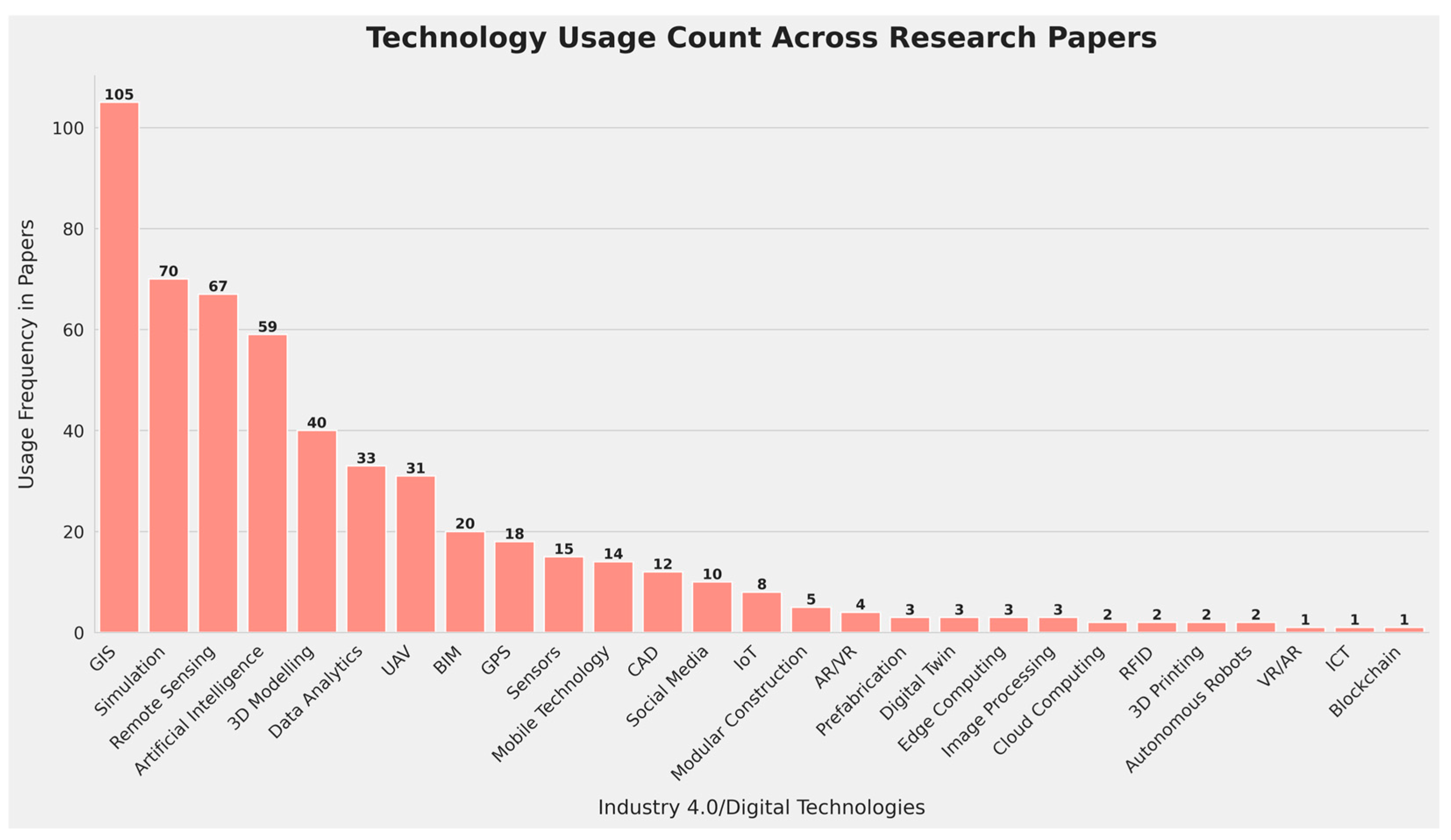
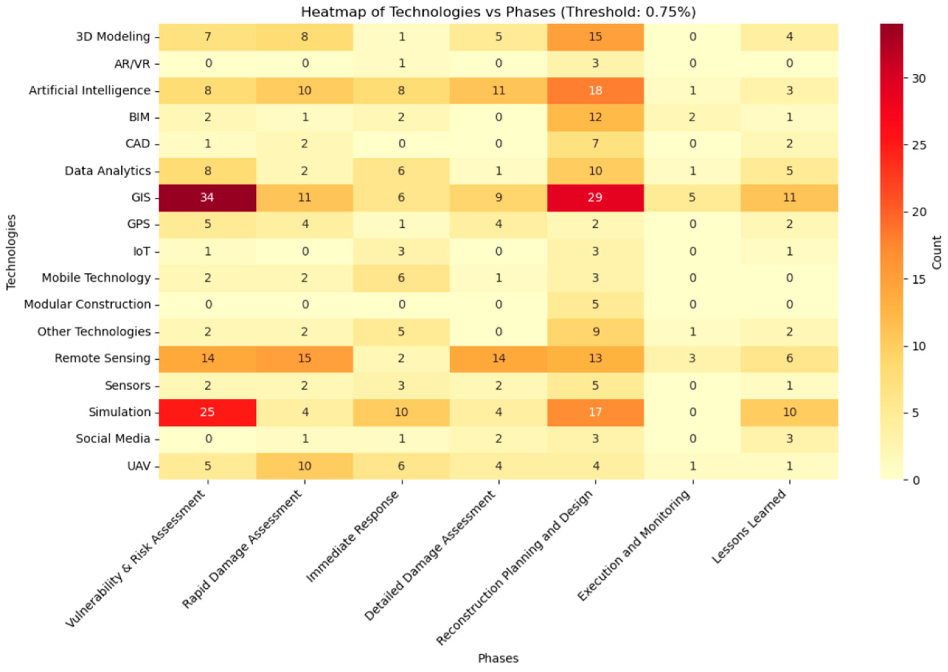
3.6. Visual Summary of Industry 4.0 Technologies Across PDR Process Phases

In recent years, the field of PDR has undergone a significant transformation driven by rapid technological advancements. Based on the results of technology usage statistics across the various phases of the PDR process, a Sankey diagram (Figure 5) has been constructed. This diagram summarizes the applications of Industry 4.0/digital technologies in different phases of the PDR process and illustrates the complex interplay between diverse technologies and their applications.

4. Future Research Directions

Several promising Industry 4.0 technologies remain underutilized in PDR, offering fertile ground for future research. AR and VR, for example, hold immense potential for enhancing community engagement and participatory planning. AR applications could overlay proposed reconstruction designs onto the real-world environment, allowing residents to visualize and interact with plans, providing feedback, and fostering a sense of ownership. VR could simulate disaster scenarios, training first responders and community members on evacuation procedures and safety measures. Research should explore the development of user-friendly AR/VR interfaces tailored to the needs of diverse communities, including those with limited technological literacy.
Another underrepresented area is the integration of blockchain technology for transparent and secure management of resources and financial aid. Blockchain could track donations, material procurement, and construction progress, ensuring accountability and minimizing the risk of corruption. Smart contracts could automate payments to contractors upon completion of verified milestones, streamlining the reconstruction process and reducing administrative overhead. Research is needed to develop blockchain-based platforms specifically designed for PDR, addressing issues of scalability, interoperability, and integration with existing systems. Further investigation into the ethical implications and potential unintended consequences of blockchain implementation is also crucial.
The “Execution and Monitoring” phase of PDR presents a significant opportunity for leveraging Industry 4.0 technologies. While some research utilizes GIS and UAVs for progress tracking, more sophisticated applications are needed. Real-time sensor data from construction sites, combined with AI-powered analytics, could monitor structural integrity, material usage, and worker safety, providing early warnings of potential problems and enabling proactive interventions. Digital twins of reconstructed infrastructure could be used for ongoing performance monitoring and predictive maintenance, enhancing long-term resilience. AI agents could automate tasks such as scheduling deliveries, optimizing resource allocation, and managing construction workflows, freeing up human personnel to focus on more complex tasks. Research should focus on developing integrated platforms that combine data from various sources, providing a holistic view of the reconstruction process and enabling data-driven decision-making. This research should also investigate the optimal division of labor between AI agents and human workers, considering factors such as safety, oversight, and the need for human expertise.
Finally, greater attention should be given to the social and psychological impacts of disasters and the role of technology in supporting community recovery. AI agents could be deployed to provide personalized information and support to affected individuals, connecting them with relevant resources, assisting with insurance claims, and facilitating access to mental health services. Social media analytics could identify vulnerable populations and direct aid where it is most needed. Research should explore the ethical considerations of using these technologies, ensuring privacy, data security, and culturally sensitive approaches to mental health care. By focusing on these underrepresented technologies and areas, future research can unlock the full potential of Industry 4.0 to build back better after disasters, creating more resilient, sustainable, and equitable communities.

5. Conclusions

This paper presents an overview of research trends in the application of Industry 4.0 technologies in post-disaster reconstruction. The study’s novelty lies in its use of small language models (SLMs) to identify relevant literature, resulting in a promising method for selecting relevant papers and identifying research gaps. The analysis draws on a dataset of 235 publications spanning from 2007 to 2024, revealing a rapidly evolving landscape of technological innovation with transformative potential in enhancing the efficiency, effectiveness, and sustainability of rebuilding efforts.
The study categorizes the publications into seven distinct phases that form a cycle: vulnerability and risk assessment, rapid damage assessment, immediate response, detailed damage assessment, reconstruction design and planning, execution and monitoring, and lessons learned. The distribution of papers across different phases suggests that reconstruction design and planning, as well as vulnerability and risk assessment, have seen significant applications of Industry 4.0/digital technologies. However, other phases, such as execution and monitoring, have been addressed by relatively few papers, indicating avenues for further exploration.
The analysis identifies several dominant technologies employed across these themes, including GIS, remote sensing, and AI. GIS and remote sensing consistently play crucial roles in damage assessment, hazard mapping, and spatial analysis, while AI is rapidly gaining prominence in tasks ranging from automated damage detection to decision support systems. Simulation enables researchers to model complex recovery scenarios and evaluate the effectiveness of different strategies, and BIM is increasingly adopted for enhancing reconstruction planning, design, and collaboration.
Several key trends emerged from the analysis, including a clear shift toward increasing automation and data-driven decision-making. AI, machine learning, and data analytics are increasingly employed to automate tasks, extract insights from large datasets, and support more informed decision-making throughout the reconstruction process. The research highlights the synergistic benefits of integrating multiple Industry 4.0/digital technologies, such as combining AI with remote sensing for damage assessment or using BIM and GIS for collaborative reconstruction planning. There is a growing emphasis on incorporating community needs, cultural values, and local knowledge into reconstruction plans, recognizing that successful reconstruction extends beyond physical rebuilding to encompass social and economic well-being.
Future research directions should focus on addressing key challenges, such as developing interoperable platforms that enable seamless data sharing and collaboration among stakeholders. Addressing the ethical implications of using AI and big data in reconstruction decision-making is also crucial, ensuring fairness, transparency, and accountability. Finally, further exploration is needed on how Industry 4.0/digital technologies can contribute to more sustainable reconstruction practices, considering environmental impacts, resource efficiency, and the use of innovative materials.

Author Contributions

Conceptualization, A.R., M.R. and E.W; methodology, A.R. and E.W.; software and programming, A.R.; validation, A.R.; formal analysis, A.R.; data curation, A.R.; visualization, A.R. and E.W.; writing—original draft preparation, A.R., M.R. and E.W.; writing—review and editing, A.R., E.W. and I.L.; supervision, E.W. and I.L.; project administration, A.R., E.W. and I.L.; funding acquisition, E.W. and I.L. All authors have read and agreed to the published version of the manuscript.

Funding

This research has been co-funded by the Housing Decarbonisation Skills for Climate, Health, and Jobs (Skills4Deca) project—grant number: DIGITAL-2022-SKILLS-03-SPECIALISED-EDU-101123311 of the European Union’s Digital Europe Programme and the Fostering Sustainable University-Industry Techno-entrepreneurial Collaborations and Innovations in Asian Universities (FOUNTAIN) project—grant number: ERASMUS-EDU-2022-CBHE-STRAND-2-101082309 of the Erasmus Plus Programme of the European Union. The European Commission’s support in producing this publication does not constitute an endorsement of the contents that reflect the views only of the authors, and the Commission cannot be held responsible for any use that may be made of the information contained therein.

Conflicts of Interest

The authors declare no conflict of interest.

References

  1. Saleh, N.; Enshassi, A.; Sundermeier, M. A Review of Resourcing Approaches in Post Disaster Housing Reconstruction. Int. J. Sustain. Constr. Eng. Technol. 2020, 11, 36–50. [Google Scholar] [CrossRef]
  2. World Bank; European Union; United Nations. The Gaza Strip Interim Damage Assessment—Summary Note 29 March 2024. 2024. Available online: https://thedocs.worldbank.org/en/doc/14e309cd34e04e40b90eb19afa7b5d15-0280012024/original/Gaza-Interim-Damage-Assessment-032924-Final.pdf (accessed on 15 June 2024).
  3. World Bank; Government of Ukraine; European Union; United Nations. UKRAINE Third Rapid Damage and Needs Assessment (RDNA3). February 2022–December 2023. 2024. Available online: https://ukraine.un.org/sites/default/files/2024-02/UA%20RDNA3%20report%20EN.pdf (accessed on 15 June 2024).
  4. Delforge, D.; Wathelet, V.; Lanfredi Sooa, C.; Tonnelier, M.; Speybroeck, N.; Below, R.; Lanfredi Sofia, C.; van Loenhout, J. EM-DAT: The Emergency Events Database. Res. Sq. 2023; preprint. [Google Scholar] [CrossRef]
  5. Choosing Europe’s Future. 2024. Available online: https://op.europa.eu/en/publication-detail/-/publication/848599a1-0901-11ef-a251-01aa75ed71a1/language-en (accessed on 15 June 2024).
  6. Council of the European Union. Circular Economy in the Construction Sector. Council Conclusions. 2019. Available online: https://data.consilium.europa.eu/doc/document/ST-14653-2019-INIT/en/pdf (accessed on 28 November 2019).
  7. Du Plessis, C. Towards a Regenerative Paradigm for the Built Environment. Build. Res. Inf. 2012, 40, 7–22. [Google Scholar] [CrossRef]
  8. Bilau, A.A.; Witt, E. An Analysis of Issues for the Management of Post-Disaster Housing Reconstruction. Int. J. Strateg. Prop. Manag. 2016, 20, 265–276. [Google Scholar] [CrossRef]
  9. UK Government. Made Smarter Review 2017, UK Department for Business, Energy and Industrial Strategy, 2017. Available online: https://assets.publishing.service.gov.uk/media/5a74fceced915d502d6cc9dd/20171027_MadeSmarter_FINAL_DIGITAL.pdf (accessed on 15 June 2024).
  10. Levac, D.; Colquhoun, H.; O’brien, K.K. Scoping Studies: Advancing the Methodology. Implement. Sci. 2010, 5, 69. [Google Scholar] [CrossRef]
  11. Tricco, A.C.; Lillie, E.; Zarin, W.; O’Brien, K.; Colquhoun, H.; Kastner, M.; Levac, D.; Ng, C.; Sharpe, J.P.; Wilson, K.; et al. A Scoping Review on the Conduct and Reporting of Scoping Reviews. BMC Med. Res. Methodol. 2016, 16, 15. [Google Scholar] [CrossRef]
  12. Dasgupta, I.; Lampinen, A.K.; Chan, S.C.Y.; Sheahan, H.R.; Creswell, A.; Kumaran, D.; McClelland, J.L.; Hill, F. Language Models Show Human-like Content Effects on Reasoning Tasks. arXiv 2022, arXiv:2207.07051. [Google Scholar]
  13. Magister, L.C.; Mallinson, J.; Adamek, J.; Malmi, E.; Severyn, A. Teaching Small Language Models to Reason. arXiv 2022, arXiv:2212.08410. [Google Scholar]
  14. Schick, T.; Schütze, H. It’s Not Just Size That Matters: Small Language Models Are Also Few-Shot Learners. arXiv 2020, arXiv:2009.07118. [Google Scholar]
  15. Brozovsky, J.; Labonnote, N.; Vigren, O. Digital Technologies in Architecture, Engineering, and Construction. Autom. Constr. 2024, 158, 105212. [Google Scholar] [CrossRef]
  16. Habibi Rad, M.; Mojtahedi, M.; Ostwald, M.J. Industry 4.0, Disaster Risk Management and Infrastructure Resilience: A Systematic Review and Bibliometric Analysis. Buildings 2021, 11, 411. [Google Scholar] [CrossRef]
  17. Dai, D.; Bo, M.; Ren, X.; Dai, K. Application and Exploration of Artificial Intelligence Technology in Urban Ecosystem-Based Disaster Risk Reduction: A Scoping Review. Ecol. Indic. 2024, 158, 111565. [Google Scholar] [CrossRef]
  18. Guha, S.; Jana, R.K.; Sanyal, M.K. Artificial Neural Network Approaches for Disaster Management: A Literature Review. Int. J. Disaster Risk Reduct. 2022, 81, 103276. [Google Scholar] [CrossRef]
  19. Ramadhan, Z.; Yunita, A. Artificial Intelligence in Natural Disaster: Data Crawling- and Text Mining-Based Literature Review. In Proceedings of the 2023 8th International Conference on Informatics and Computing, ICIC 2023, Manado, Indonesia, 8–9 December 2023; Institute of Electrical and Electronics Engineers Inc.: New York, NY, USA, 2023. [Google Scholar]
  20. Sünbül, G.; Soyluk, A. A Review of Using Deep Learning Technology in the Built Environment of Disaster Management Phases. J. Archit. Sci. Appl. 2024, 9, 201–218. [Google Scholar] [CrossRef]
  21. Munawar, H.S.; Mojtahedi, M.; Hammad, A.W.A.; Kouzani, A.; Mahmud, M.A.P. Disruptive Technologies as a Solution for Disaster Risk Management: A Review. Sci. Total. Environ. 2022, 806, 151351. [Google Scholar] [CrossRef]
  22. Yu, M.; Yang, C.; Li, Y. Big Data in Natural Disaster Management: A Review. Geosciences 2018, 8, 165. [Google Scholar] [CrossRef]
  23. Baas, J.; Schotten, M.; Plume, A.; Côté, G.; Karimi, R. Scopus as a Curated, High-Quality Bibliometric Data Source for Academic Research in Quantitative Science Studies. Quant. Sci. Stud. 2020, 1, 377–386. [Google Scholar] [CrossRef]
  24. GitHub—Ollama/Ollama: Get up and Running with Llama 3.2, Mistral, Gemma 2, and Other Large Language Models. Available online: https://github.com/ollama/ollama (accessed on 25 September 2024).
  25. Chase, H. LangChain. GitHub. 2022. Available online: https://github.com/langchain-ai/langchain (accessed on 15 June 2024).
  26. Giray, L. Prompt Engineering with ChatGPT: A Guide for Academic Writers. Ann. Biomed. Eng. 2023, 51, 2629–2633. [Google Scholar] [CrossRef]
  27. Yazan, M.; Verberne, S.; Situmeang, F. The Impact of Quantization on Retrieval-Augmented Generation: An Analysis of Small LLMs. arXiv 2024, arXiv:2406.10251. [Google Scholar]
  28. Shahinzadeh, H.; Zanjani, S.M.H.; Moradi, J.; Iranpour, M.; Yasci, W.; Benbouzid, M. Resilience Assessment of Distribution Systems Against Extreme Weather Events: Flooding Threats in Iran’s Electricity Network. In Proceedings of the IEEE Global Energy Conference, GEC 2022, Batman, Turkey, 26–29 October 2022; Institute of Electrical and Electronics Engineers Inc.: New York, NY, USA, 2022; pp. 247–252. [Google Scholar]
  29. Sousa, H.; Rozsas, A.; Slobbe, A.; Courage, W. A Novel Pro-Active Approach towards SHM-Based Bridge Management Supported by FE Analysis and Bayesian Methods. Struct. Infrastruct. Eng. 2020, 16, 233–246. [Google Scholar] [CrossRef]
  30. Bianco, M.; Cimellaro, G.P.; Wilkinson, S. Virtual City for Water Distribution Research in Crisis Management. In Proceedings of the COMPDYN 2017—6th International Conference on Computational Methods in Structural Dynamics and Earthquake Engineering, Rhodes Island, Greece, 15–17 June 2017; National Technical University of Athens: Athens, Greece, 2017; Volume 1, pp. 2075–2088. [Google Scholar]
  31. Kou, Z.; Li, N. Study on Earthquake Resilience Analysis and Optimization for Urban Bridge Network System Based on NSGA-II Algorithm. Gongcheng Lixue/Eng. Mech. 2021, 38, 148–158. [Google Scholar] [CrossRef]
  32. Sousa, J.J.; Lin, J.; Wang, Q.; Liu, G.; Fan, J.; Bai, S.; Zhao, H.; Pan, H.; Wei, W.; Rittlinger, V.; et al. Using Machine Learning and Satellite Data from Multiple Sources to Analyze Mining, Water Management, and Preservation of Cultural Heritage. Geo-Spat. Inf. Sci. 2024, 27, 552–571. [Google Scholar] [CrossRef]
  33. Li, G.; Zhao, J.; Murray, V.; Song, C.; Zhang, L. Gap Analysis on Open Data Interconnectivity for Disaster Risk Research. Geo-Spat. Inf. Sci. 2019, 22, 45–58. [Google Scholar] [CrossRef]
  34. Horvat, M.; Krtalić, A.; Akagić, A.; Mekterović, I. Ontology-Based Data Observatory for Formal Knowledge Representation of UXO Using Advanced Semantic Web Technologies. Electronics 2024, 13, 814. [Google Scholar] [CrossRef]
  35. Dou, A.X.; Yuan, X.X.; Wang, X.Q.; Li, Z.M. Refinement Method for Residential Area Revision Using Remote Sensing Image and GIS Data in Earthquake Risk Assessment. In Proceedings of the International Archives of the Photogrammetry, Remote Sensing and Spatial Information Sciences—ISPRS Archives, Prague, Czech Republic, 12–19 July 2016; International Society for Photogrammetry and Remote Sensing: Tempe, AZ, USA, 2016; Volume 41, pp. 51–54. [Google Scholar]
  36. Su, Y.S. Rebuild, Retreat or Resilience: Urban Flood Vulnerability Analysis and Simulation in Taipei. Int. J. Disaster Resil. Built. Environ. 2017, 8, 110–122. [Google Scholar] [CrossRef]
  37. Hou, S.; Cao, P.; Li, A.; Chen, L.; Feng, Z.; Liu, J.; Wang, L. Debris Flow Hazard Assessment of the Eryang River Watershed Based on Numerical Simulation. In Proceedings of the IOP Conference Series: Earth and Environmental Science; IOP Publishing Ltd.: Bristol, UK, 2021; Volume 861. [Google Scholar]
  38. Martin del Campo, F.; Singh, S.J.; Fishman, T.; Thomas, A.; Drescher, M. The Bahamas at Risk: Material Stocks, Sea-Level Rise, and the Implications for Development. J. Ind. Ecol. 2023, 27, 1165–1183. [Google Scholar] [CrossRef]
  39. Capra, L.; Gavilanes-Ruiz, J.C.; Bonasia, R.; Saucedo-Giron, R.; Sulpizio, R. Re-Assessing Volcanic Hazard Zonation of Volcán de Colima, México. Nat. Hazards 2015, 76, 41–61. [Google Scholar] [CrossRef]
  40. Vegad, U.; Pokhrel, Y.; Mishra, V. Flood Risk Assessment for Indian Sub-Continental River Basins. Hydrol. Earth Syst. Sci. 2024, 28, 1107–1126. [Google Scholar] [CrossRef]
  41. Cavallaro, M.; Asprone, D.; Latora, V.; Manfredi, G.; Nicosia, V. Assessment of Urban Ecosystem Resilience through Hybrid Social-Physical Complex Networks. Comput.-Aided Civ. Infrastruct. Eng. 2014, 29, 608–625. [Google Scholar] [CrossRef]
  42. Wicaksono, B.; Siswanto, A.; Fransiska, W.; Kusdiwanggo, S. Disaster and Resilient Infrastructures at Musi Riverside Settlement in Palembang. In Proceedings of the IOP Conference Series: Earth and Environmental Science; Institute of Physics: Philadelphia, PA, USA, 2022; Volume 1065. [Google Scholar]
  43. Lamaury, Y.; Jessin, J.; Heinzlef, C.; Serre, D. Operationalizing Urban Resilience to Floods in Island Territories—Application in Punaauia, French Polynesia. Water 2021, 13, 337. [Google Scholar] [CrossRef]
  44. Nicolosi, V.; Augeri, M.; D’Apuzzo, M.; Evangelisti, A.; Santilli, D. A Probabilistic Approach to the Evaluation of Seismic Resilience in Road Asset Management. Int. J. Disaster Risk Sci. 2022, 13, 114–124. [Google Scholar] [CrossRef]
  45. Alabbad, Y.; Mount, J.; Campbell, A.M.; Demir, I. Assessment of Transportation System Disruption and Accessibility to Critical Amenities during Flooding: Iowa Case Study. Sci. Total Environ. 2021, 793, 148476. [Google Scholar] [CrossRef] [PubMed]
  46. Kim, J.; Park, S.; Kim, M. Safety Map: Disaster Management Road Network for Urban Resilience. Sustain. Cities Soc. 2023, 96, 104650. [Google Scholar] [CrossRef]
  47. Bhattacharyya, A.; Morshedi, M.; Hastak, M. A Clustering-Classification Approach in Categorizing Vulnerability of Roads and Bridges Using Public Assistance Big Data. Int. J. Disaster Risk Reduct. 2023, 84, 103448. [Google Scholar] [CrossRef]
  48. Xuan, G.; Lin, J.; Liu, J. Construction of Seismic Disaster Scenario for Road Traffic Network in Mountainous City. In Proceedings of the International Conference on Smart Transportation and City Engineering, Chongqing, China, 6–8 August 2021; SPIE: Philadelphia, PA, USA, 2021; p. 5. [Google Scholar]
  49. Miao, S.; Haifen, J. Seismic Capacity Evaluation of Existing Residential Buildings Based on Big Data. J. Phys. Conf. Ser. 2022, 2202, 012025. [Google Scholar]
  50. Sakaba, N.; Harumi, Y. Construction of Damage Function for an Analysis of the Economic Damage by Earthquakes with a Focus on the Reconstruction of Shared Housing. Int. J. Geomate 2021, 20, 135–141. [Google Scholar] [CrossRef]
  51. Rautela, P.; Chandra Joshi, G.; Bhaisora, B. Seismic Vulnerability of the Health Infrastructure in the Himalayan Township of Mussoorie, Uttarakhand, India. Int. J. Disaster Resil. Built Environ. 2011, 2, 200–209. [Google Scholar] [CrossRef]
  52. Yamin, L.E.; Rincon, R.; Fernández, R.; Reyes, J.C. Repair Cost and Downtime Seismic Vulnerability Assessment for RC School Buildings. In Proceedings of the Eleventh US National Conference on Earthquake Engineering, Los Angeles, CA, USA, 25–29 June 2018. [Google Scholar]
  53. Diaz, R.; Behr, J.G.; Acero, B.; Giles, B.D.; Yusuf, J.E.W. A Simulation-Based Disaster Management Framework to Analyze Housing Recovery: The Case of Hampton Roads, USA. IEEE Trans. Eng. Manag. 2024, 71, 4587–4601. [Google Scholar] [CrossRef]
  54. Doko, T.; Chen, W.; Sasaki, K.; Furutani, T. An Attempt to Develop an Environmental Information System of Ecological Infrastructure for Evaluating Functions of Ecosystem-Based Solutions for Disaster Risk Reduction (Eco-DRR). In Proceedings of the International Archives of the Photogrammetry, Remote Sensing and Spatial Information Sciences—ISPRS Archives, Prague, Czech Republic, 12–19 July 2016; International Society for Photogrammetry and Remote Sensing: Tempe, AZ, USA, 2016; Volume 41, pp. 43–49. [Google Scholar]
  55. García-Torres, S.; Kahhat, R.; Santa-Cruz, S. Methodology to Characterize and Quantify Debris Generation in Residential Buildings after Seismic Events. Resour. Conserv. Recycl. 2017, 117, 151–159. [Google Scholar] [CrossRef]
  56. Nguyen, H.P. Earthquake-tsunami hazard assessment and risk mitigation in Vietnam using GIS. Int. Symp. Grids Clouds Open Grid Forum 2011, 77. [Google Scholar]
  57. Wu, Z.; Ni, Y. A Disaster-Recovery IT Framework Based on Disaster Indexing Measurement Mechanism in E-Government. In Proceedings of the 2009 International Conference on Management of e-Commerce and e-Government, Nanchang, China, 16–19 September 2009; ICMeCG 2009. pp. 87–90. [Google Scholar]
  58. Zou, Z.C.; Lin, X.G. Zero Cost Solutions of Geo-Informatics Acquisition, Collection and Production for Natural Disaster Risk Assessment. In Proceedings of the 20th International Congress on Modelling and Simulation, Adelaide, Australia, 27–30 November 2013. [Google Scholar]
  59. Hirayama, N.; Shimaoka, T.; Fujiwara, T.; Okayama, T.; Kawata, Y. Implementation of intelligence of flood disaster debris discharge for emergency response. WIT Trans. Inf. Commun. Technol. 2010, 43, 681–692. [Google Scholar]
  60. Schmitt, R.J.P.; Virgüez, E.; Ashfaq, S.; Caldeira, K. Move up or Move over: Mapping Opportunities for Climate Adaptation in Pakistan’s Indus Plains. Environ. Res. Lett. 2023, 18, 114024. [Google Scholar] [CrossRef]
  61. Kano, M.; Nagao, H.; Nagata, K.; Ito, S.; Sakai, S.; Nakagawa, S.; Hori, M.; Hirata, N. Seismic Wavefield Imaging of Long-Period Ground Motion in the Tokyo Metropolitan Area, Japan. J. Geophys. Res. Solid. Earth 2017, 122, 5435–5451. [Google Scholar] [CrossRef]
  62. Su, G.; Qi, W.; Zhang, S.; Sim, T.; Liu, X.; Sun, R.; Sun, L.; Jin, Y. An Integrated Method Combining Remote Sensing Data and Local Knowledge for the Large-Scale Estimation of Seismic Loss Risks to Buildings in the Context of Rapid Socioeconomic Growth: A Case Study in Tangshan, China. Remote. Sens. 2015, 7, 2543–2601. [Google Scholar] [CrossRef]
  63. Munirwansyah, M.; Munirwan, R.P.; Sungkar, M.; Melinda, Z. The Effect of Soil-Structure Interaction on Multi-Storey Building Resonance and Dynamic Shear Modulus for Pidie Jaya Aceh Earthquake. IOP Conf. Ser. Mater. Sci. Eng. 2019, 523, 012038. [Google Scholar] [CrossRef]
  64. Ahmad, N.; Ali, Q.; Crowley, H.; Pinho, R. Earthquake Loss Estimation of Residential Buildings in Pakistan. Nat. Hazards 2014, 73, 1889–1955. [Google Scholar] [CrossRef]
  65. Zhu, J.; Zhang, Y.; Zhang, J.; Chen, Y.; Liu, Y.; Liu, H. Multi-Criteria Seismic Risk Assessment Based on Combined Weight-TOPSIS Model and CF-Logistic Regression Model—A Case Study of Songyuan City, China. Sustainability 2023, 15, 11216. [Google Scholar] [CrossRef]
  66. Chen, X.; Lan, J. Impact of Slope Stability Changes on Landslide Activity near the Epicenter of the 2008 Wenchuan Ms8.0 Earthquake, China. Bull. Eng. Geol. Environ. 2021, 80, 5259–5270. [Google Scholar] [CrossRef]
  67. Hao, H.; Wang, Y.; Wang, Q.; Professor, A. Simulating Urban Population Activities under Extreme Events with Data-Driven Agent-Based Modeling. In Construction Research Congress 2022; American Society of Civil Engineers: Reston, VA, USA, 2022; pp. 1125–1134. [Google Scholar]
  68. Loos, S.; Lallemant, D.; Khan, F.; McCaughey, J.W.; Banick, R.; Budhathoki, N.; Baker, J.W. A Data-Driven Approach to Rapidly Estimate Recovery Potential to Go beyond Building Damage after Disasters. Commun. Earth Environ. 2023, 4, 40. [Google Scholar] [CrossRef]
  69. Maity, S.; Sundar, S.; Kuhnert, J. A High-Resolution Meshfree Particle Method for Numerical Investigation of Second-Order Macroscopic Pedestrian Flow Models. Appl. Math. Model. 2024, 131, 205–232. [Google Scholar] [CrossRef]
  70. Massei, M.; Poggi, S.; Agresta, M.; Ferrando, A. Development Planning Based on Interoperable Agent Driven Simulation. J. Comput. Sci. 2014, 5, 395–407. [Google Scholar] [CrossRef]
  71. Hao, H.; Wang, Y. Leveraging Multimodal Social Media Data for Rapid Disaster Damage Assessment. Int. J. Disaster Risk Reduct. 2020, 51, 101760. [Google Scholar] [CrossRef]
  72. Zhang, B.; Lei, L.; Zhang, L.; Liu, L.; Zhu, B.; Zuo, Z. Application of Optical Remote Sensing in the Wenchuan Earthquake Assessment. In Proceedings of the Second International Conference on Earth Observation for Global Changes, Chengdu, China, 25–29 May 2009; SPIE: Philadelphia, PA, USA, 2009. [Google Scholar]
  73. Wang, Z.; Yang, X. An Edge-Suppressed Points Voting Method for Extracting Rural Residential Areas from High Spatial Resolution Images. Remote Sens. Lett. 2017, 8, 380–388. [Google Scholar] [CrossRef]
  74. Kashtan, V.Y.; Hnatushenko, V.V. Automated Building Damage Detection on Digital Imagery Using Machine Learning. Natsional’nyi Hirnychyi Universytet. Nauk. Visnyk 2023, 6, 134–140. [Google Scholar] [CrossRef]
  75. Vatsavai, R.R. Rapid Damage Explorer (RDX): A Probabilistic Framework for Learning Changes from Bitemporal Images. In Proceedings of the 12th IEEE International Conference on Data Mining Workshops, Brussels, Belgium, 10 December 2012; ICDMW 2012. pp. 906–909. [Google Scholar]
  76. Xu, Z.; Chen, Y.; Yang, F.; Chu, T.; Zhou, H. A Postearthquake Multiple Scene Recognition Model Based on Classical SSD Method and Transfer Learning. ISPRS Int. J. Geoinf. 2020, 9, 238. [Google Scholar] [CrossRef]
  77. Wen, Q.; He, H.; Wang, X.; Wu, W.; Wang, L.; Xu, F.; Wang, P.; Tang, T.; Lei, Y. UAV Remote Sensing Hazard Assessment in Zhouqu Debris Flow Disaster. In Proceedings of the Remote Sensing of the Ocean, Sea Ice, Coastal Waters, and Large Water Regions 2011, Berlin, Germany, 10–12 October 2011; SPIE: Philadelphia, PA, USA, 2011; Volume 8175, p. 817510. [Google Scholar]
  78. Peng, X.; Su, G.; Folk, B.; Chen, Z.; Sengupta, R. Autonomous UAV-Based Structural Damage Exploration Platform for Post-Disaster Reconnaissance. Comput. Civ. Eng. 2023, 2024, 10–18. [Google Scholar]
  79. Wladdimiro, D.; Gonzalez-Cantergiani, P.; Hidalgo, N.; Rosas, E. Disaster Management Platform to Support Real-Time Analytics. In Proceedings of the 2016 3rd International Conference on Information and Communication Technologies for Disaster Management (ICT-DM), Vienna, Austria, 13–15 December 2016. [Google Scholar]
  80. Guo, C.; Li, C.; Yang, Z.; Ni, J.; Zhong, N.; Wang, M.; Yan, Y.; Song, D.; Zhang, Y.; Zhang, X.; et al. Characterization and Spatial Analysis of Coseismic Landslides Triggered by the Luding Ms 6.8 Earthquake in the Xianshuihe Fault Zone, Southwest China. J. Mt. Sci. 2024, 21, 160–181. [Google Scholar] [CrossRef]
  81. Wang, L.; Li, Z.; Han, J.; Fan, K.; Chen, Y.; Wang, J.; Fu, J. A Cost-Effective Earthquake Disaster Assessment Model for Power Systems Based on Nighttime Light Information. Appl. Sci. 2024, 14, 2325. [Google Scholar] [CrossRef]
  82. Nagata, T.; Nakai, K.; Yamada, K.; Saito, Y.; Nonomura, T.; Kano, M.; Ito, S.; Nagao, H. Seismic Wavefield Reconstruction Based on Compressed Sensing Using Data-Driven Reduced-Order Model. Geophys. J. Int. 2023, 233, 33–50. [Google Scholar] [CrossRef]
  83. Fauzan; Carol, N.D.; Ismail, F.A.; Narny, Y. Implementation of a Quick Assessment Application Called InaRISK for Damaged Houses after the West Pasaman Earthquake (2022). In Proceedings of the IOP Conference Series: Earth and Environmental Science; Institute of Physics, IOP Publishing: Bristol, UK, 2023; Volume 1244, p. 012041. [Google Scholar]
  84. Dabove, P.; Di Pietra, V.; Lingua, A.M. Close Range Photogrammetry with Tablet Technology in Post-Earthquake Scenario: Sant’Agostino Church in Amatrice. Geoinformatica 2018, 22, 463–477. [Google Scholar] [CrossRef]
  85. Wang, H.; Feng, D. Rapid Geometric Evaluation of Transportation Infrastructure Based on a Proposed Low-Cost Portable Mobile Laser Scanning System. Sensors 2024, 24, 425. [Google Scholar] [CrossRef] [PubMed]
  86. Yang, Y.; Nagarajaiah, S. Data Compression of Structural Seismic Responses via Principled Independent Component Analysis. J. Struct. Eng. 2014, 140, 425. [Google Scholar] [CrossRef]
  87. Pham, T.T.H.; Apparicio, P.; Gomez, C.; Weber, C.; Mathon, D. Towards a Rapid Automatic Detection of Building Damage Using Remote Sensing for Disaster Management: The 2010 Haiti Earthquake. Disaster Prev. Manag. Int. J. 2014, 23, 53–66. [Google Scholar] [CrossRef]
  88. Thunig, H.; Michel, U.; Ehlers, M.; Reinartz, P. Object-Based Rapid Change Detection for Disaster Management. In Proceedings of the Earth Resources and Environmental Remote Sensing/GIS Applications II, Toulouse, France, 20–22 September 2011; SPIE: Philadelphia, PA, USA, 2011; Volume 8181, p. 81810. [Google Scholar]
  89. Hong, Z.; Zhang, H.; Tong, X.; Liu, S.; Zhou, R.; Pan, H.; Zhang, Y.; Han, Y.; Wang, J.; Yang, S. Rapid Fine-Grained Damage Assessment of Buildings on a Large Scale: A Case Study of the February 2023 Earthquake in Turkey. IEEE J. Sel. Top Appl. Earth Obs. Remote Sens. 2024, 17, 5204–5220. [Google Scholar] [CrossRef]
  90. Jamshad, R.; Qureshi, M.U.; Grijalva, S. Geographic Information Systems (GIS) Image Analysis for Prioritizing Power System Restoration. In Proceedings of the 2018 Clemson University Power Systems Conference, PSC 2018, Charleston, SC, USA, 4–7 September 2018; Institute of Electrical and Electronics Engineers Inc.: Palo Alto, CA, USA, 2019. [Google Scholar]
  91. Zhang, L.; Li, A.; Zhang, Z.; Yang, K. Global and Local Saliency Analysis for the Extraction of Residential Areas in High-Spatial-Resolution Remote Sensing Image. IEEE Trans. Geosci. Remote Sens. 2016, 54, 3750–3763. [Google Scholar] [CrossRef]
  92. Pamuncak, A.; Guo, W.; Khaled, A.S.; Laory, I. Deep Learning for Bridge Load Capacity Estimation in Post-Disaster and -Conflict Zones. R. Soc. Open Sci. 2019, 6, 190227. [Google Scholar] [CrossRef]
  93. An, L.; Zhang, J.; Gong, L.; Li, Q. Integration of SAR image and vulnerability data for building damage degree estimation. In Proceedings of the 2016 IEEE International Geoscience and Remote Sensing Symposium (IGARSS), Beijing, China, 10–15 July 2016; pp. 4263–4266. [Google Scholar]
  94. Chen, J.; Han, G.; Chen, L.; Zhao, Y.; Jin, S.; Wang, F. Integrated Geospatial Information Service for Disaster Management in China’s Wenchuan Earthquake. Available online: https://www.isprs.org/proceedings/2011/Gi4DM/PDF/OP29.pdf (accessed on 15 June 2024).
  95. Golparvar-Fard, M.; Thomas, J.; Peña-Mora, F.; Savarese, S. Remote assessment of pre-and post-disaster critical physical infrastructures using mobile workstation chariot and D4AR models. In Proceedings of the International Conference on Computing in Civil and Building Engineering; Springer: Nottingham, UK, 2010; pp. 63–69. [Google Scholar]
  96. Yajima, Y.; Kim, S.; Chen, J.; Cho, Y.K. Fast Online Incremental Segmentation of 3D Point Clouds from Disaster Sites. In Proceedings of the International Symposium on Automation and Robotics in Construction, Online, 2–4 November 2021. [Google Scholar]
  97. Doherty, P.; Kvarnström, J.; Rudol, P.; Wzorek, M.; Conte, G.; Berger, C.; Hinzmann, T.; Stastny, T. A Collaborative Framework for 3D Mapping Using Unmanned Aerial Vehicles. In PRIMA 2016: Principles and Practice of Multi-Agent Systems: 19th International Conference, Phuket, Thailand, 22–26 August 2016; Springer International Publishing: Cham, Switzerland, 2016. [Google Scholar]
  98. Opdyke, A.; Javernick-Will, A. Building coordination capacity: Post-disaster organizational twitter networks. In Proceedings of the IEEE Global Humanitarian Technology Conference (GHTC 2014), San Jose, CA, USA, 10–13 October 2014; pp. 86–92. [Google Scholar]
  99. Lu, L.; Guo, W. Automatic Quantification of Settlement Damage Using Deep Learning of Satellite Images. In Proceedings of the 2021 IEEE International Smart Cities Conference (ISC2), Manchester, UK, 7–10 September 2021. [Google Scholar]
  100. Bisio, I.; Garibotto, C.; Lavagetto, F.; Sciarrone, A.; Zerbino, M. Investigating Compressive Sensing Applications through Real Infrastructures Inertial Signals Analysis. In Proceedings of the IEEE Global Communications Conference, GLOBECOM, Kuala Lumpur, Malaysia, 4–8 December 2023; Institute of Electrical and Electronics Engineers Inc.: New York, NY, USA, 2023; pp. 279–284. [Google Scholar]
  101. John Samuel Raj, K.; Naresh Kumar Thapa, K.; Balakrishnan, R. Post Disaster Damage Estimation Using Integrated GPS Sensor Network & GIS. In Proceedings of the 2016 IEEE International Conference on Wireless Communications, Signal Processing and Networking, Chennai, India, 23–25 March 2016; WiSPNET 2016. Presses Polytechniques Et Universitaires Romandes: Lyon, France, 2016; pp. 1234–1238. [Google Scholar]
  102. Babvey, P.; Gongora-Svartzman, G.; Lipizzi, C.; Ramirez-Marquez, J.E. Content-Based User Classifier to Uncover Information Exchange in Disaster-Motivated Networks. PLoS ONE 2021, 16, e0259342. [Google Scholar] [CrossRef]
  103. Takahashi, N.; Chikasada, N.; Imai, K. Real-Time Tsunami Damage Prediction Using DONET and the Implementation. In Proceedings of the 2023 IEEE International Symposium on Underwater Technology, UT 2023, Tokyo, Japan, 6–9 March 2023; Institute of Electrical and Electronics Engineers Inc.: New York, NY, USA, 2023. [Google Scholar]
  104. Andrea, A.; Terzo, O. High Availability Systems for Geographic Information. Titolo Volume Non Avvalorato 2010. Available online: https://core.ac.uk/outputs/11419886/?utm_source=pdf&utm_medium=banner&utm_campaign=pdf-decoration-v1 (accessed on 10 June 2024).
  105. Wang, J.; Sato, K.; Guo, S.; Chen, W.; Wu, J. Big Data Processing with Minimal Delay and Guaranteed Data Resolution in Disaster Areas. IEEE Trans. Veh. Technol. 2019, 68, 3833–3842. [Google Scholar] [CrossRef]
  106. Dorj, E.; Kinoshita, K. A Route Reconstruction Method with Spare AP for Wireless Mesh Networks in Disaster Situation. In Proceedings of the ACM International Conference Proceeding Series; Association for Computing Machinery, Online, 25–28 November 2018. [Google Scholar]
  107. Menon, V.G.; Joe Prathap, P.M. Analysing the Behaviour and Performance of Opportunistic Routing Protocols in Highly Mobile Wireless Ad Hoc Networks. Int. J. Eng. Technol. 2016, 8, 1916–1924. [Google Scholar] [CrossRef]
  108. Anitha, K.; Khadri, T.; Prurvimuth, T.; Venkatesh, T.D.; Nesarikar, Y. Wide Area Disaster Management System Using Mobile Intranet. Int. J. Eng. Adv. Technol. 2019, 8, 80–83. [Google Scholar] [CrossRef]
  109. Castellanos, C.L.; Marti, J.R.; Sarkaria, S. Distributed reinforcement learning framework for resource allocation in disaster response. In Proceedings of the 2018 IEEE Global Humanitarian Technology Conference (GHTC), San Jose, CA, USA, 18-21 October 2018; pp. 1–8. [Google Scholar]
  110. Luan, Q.; Cui, H.; Zhang, L.; Lv, Z. A Hierarchical Hybrid Subtask Scheduling Algorithm in UAV-Assisted MEC Emergency Network. IEEE Internet Things J. 2022, 9, 12737–12753. [Google Scholar] [CrossRef]
  111. Peng, G.; Xia, Y.; Zhang, X.; Bai, L. UAV-Aided Networks for Emergency Communications in Areas with Unevenly Distributed Users. J. Commun. Inf. Netw. 2018, 3, 23–32. [Google Scholar] [CrossRef]
  112. Guo, C.; Yan, Z.; Liu, T. Application of the Tunnel Fire Scenario Dynamic Reconstruction Based on Intelligent Disaster Prevention Platform in Shanghai. In Proceedings of the IOP Conference Series: Earth and Environmental Science; IOP Publishing Ltd.: Bristol, UK, 2021; Volume 861. [Google Scholar]
  113. Akbari, V.; Shiri, D.; Sibel Salman, F. An Online Optimization Approach to Post-Disaster Road Restoration. Transp. Res. Part. B Methodol. 2021, 150, 1–25. [Google Scholar] [CrossRef]
  114. Alshaikh, M.; Morie, A. Development of Multipath Dynamic Address Routing Protocol in MANET to Improve Data Transfer in Poor Infrastructure Environment. In Proceedings of the 2nd 2022 International Conference on Computer Science and Software Engineering, CSASE 2022, Duhok, Iraq, 15–17 March 2022; Institute of Electrical and Electronics Engineers Inc.: New York, NY, USA, 2022; pp. 368–373. [Google Scholar]
  115. Menon, V.G.; Pathrose, J.P.; Priya, J. Ensuring Reliable Communication in Disaster Recovery Operations with Reliable Routing Technique. Mob. Inf. Syst. 2016, 2016, 9141329. [Google Scholar] [CrossRef]
  116. Dong, S. Optimization of AODV Routing Protocol in Emergency Communication Network. In Proceedings of the ITNEC 2023—IEEE 6th Information Technology, Networking, Electronic and Automation Control Conference, Chongqing, China, 24–26 February 2023; Institute of Electrical and Electronics Engineers Inc.: New York, NY, USA, 2023; pp. 1441–1444. [Google Scholar]
  117. Nguyen, L.M.D.; Vo, V.N.; So-In, C.; Dang, V.H. Throughput Analysis and Optimization for NOMA Multi-UAV Assisted Disaster Communication Using CMA-ES. Wirel. Netw. 2021, 27, 4889–4902. [Google Scholar] [CrossRef]
  118. Yang, B.; Xiong, X.; Liu, H.; Jia, Y.; Gao, Y.; Tolba, A.; Zhang, X. Unmanned Aerial Vehicle Assisted Post-Disaster Communication Coverage Optimization Based on Internet of Things Big Data Analysis. Sensors 2023, 23, 6795. [Google Scholar] [CrossRef]
  119. Cheikhrouhou, O.; Koubaa, A.; Zarrad, A. A Cloud Based Disaster Management System. J. Sens. Actuator Netw. 2020, 9, 6. [Google Scholar] [CrossRef]
  120. Vizvári, B.; Golabi, M.; Nedjati, A.; Gümüşbuğa, F.; Izbirak, G. Top-down Approach to Design the Relief System in a Metropolitan City Using UAV Technology, Part I: The First 48 h. Nat. Hazards 2019, 99, 571–597. [Google Scholar] [CrossRef]
  121. Kim, J.; Hayashi, Y. Distributed Self-Healing for Resilient Network Design in Local Resource Allocation Control. Front. Phys. 2022, 10, 870560. [Google Scholar] [CrossRef]
  122. Majidi, S.; Omidalizarandi, M.; Sharifi, M.A. Intelligent 3D Crack Reconstruction Using Close Range Photogrammetry Imagery. In Proceedings of the ISPRS Annals of the Photogrammetry, Remote Sensing and Spatial Information Sciences, Copernicus Publications, Tehran, Iran, 13 January 2023; Volume 10, pp. 443–450. [Google Scholar]
  123. Wu, K.S.; He, Y.R.; Chen, Q.-J.; Zheng, Y. mao Analysis on the Damage and Recovery of Typhoon Disaster Based on UAV Orthograph. Microelectron. Reliab. 2020, 107, 113337. [Google Scholar] [CrossRef]
  124. Gong, J. A Remote Sensing-Based Approach for Assessing and Visualizing Post-Sandy Damage and Resiliency Rebuilding Needs. Available online: https://ascelibrary.org/doi/abs/10.1061/9780784413517.129 (accessed on 17 June 2024).
  125. Gutiérrez Viñuales, M.; Puch Sleive, E.; Chalabe, S. Experiences in Cadastral Restitution at a Town Affected by a Natural Disaster. the Case of Volcan, Jujuy Province, Argentina. In Proceedings of the International Archives of the Photogrammetry, Remote Sensing and Spatial Information Sciences—ISPRS Archives, Warsaw, Poland, 16–17 September 2019; International Society for Photogrammetry and Remote Sensing: Tempe, AZ, USA, 2019; Volume 42, pp. 343–347. [Google Scholar]
  126. De Martino, G.; Marotta, P.; Di Ludovico, M.; Iannella, S.; Albanese, V.; Prota, A. The Reconstruction Process of the Buildings Damaged by the 2017 Ischia Earthquake. In Proceedings of the Procedia Structural Integrity, Dubrovnik, Croatia, 20–23 September 2022; Elsevier B.V.: Amsterdam, The Netherlands, 2022; Volume 44, pp. 1816–1823. [Google Scholar]
  127. Yang, Y.; Nagarajaiah, S. Robust Data Transmission and Recovery of Images by Compressed Sensing for Structural Health Diagnosis. Struct. Control Health Monit. 2017, 24, e1856. [Google Scholar] [CrossRef]
  128. Mandirola, M.; Casarotti, C.; Peloso, S.; Lanese, I.; Brunesi, E.; Senaldi, I. Use of UAS for Damage Inspection and Assessment of Bridge Infrastructures. Int. J. Disaster Risk Reduct. 2022, 72, 102824. [Google Scholar] [CrossRef]
  129. Huang, L.; Fan, G.; Li, J.; Hao, H. Deep Learning for Automated Multiclass Surface Damage Detection in Bridge Inspections. Autom. Constr. 2024, 166, 105601. [Google Scholar] [CrossRef]
  130. Taupe, P.; Preinerstorfer, A.; Amon, P. UAV-Borne LiDAR and Morphological Filtering for Automatic Monitoring of Alpine Protective Infrastructure; SPIE-International Society for Optical Engineering: Philadelphia, PA, USA, 2021; p. 15. [Google Scholar]
  131. Tanikawa, H.; Managi, S.; Lwin, C.M. Estimates of Lost Material Stock of Buildings and Roads Due to the Great East Japan Earthquake and Tsunami. J. Ind. Ecol. 2014, 18, 421–431. [Google Scholar] [CrossRef]
  132. Majeed, U.; Rashid, I.; Sattar, A.; Allen, S.; Stoffel, M.; Nüsser, M.; Schmidt, S. Recession of Gya Glacier and the 2014 Glacial Lake Outburst Flood in the Trans-Himalayan Region of Ladakh, India. Sci. Total Environ. 2021, 756, 144008. [Google Scholar] [CrossRef] [PubMed]
  133. Diakakis, M.; Andreadakis, E.; Nikolopoulos, E.I.; Spyrou, N.I.; Gogou, M.E.; Deligiannakis, G.; Katsetsiadou, N.K.; Antoniadis, Z.; Melaki, M.; Georgakopoulos, A.; et al. An Integrated Approach of Ground and Aerial Observations in Flash Flood Disaster Investigations. The Case of the 2017 Mandra Flash Flood in Greece. Int. J. Disaster Risk Reduct. 2019, 33, 290–309. [Google Scholar] [CrossRef]
  134. McDougall, K.; Temple-Watts, P. The Use of Lidar and Volunteered Geographic Information to Map Flood Extents and Inundation. Remote. Sens. Spat. Inf. Sci. 2012, I-4, 251–256. [Google Scholar]
  135. Litvinova, I.N.; Karagodina, O.A. Historical and Architectural Heritage of Volgograd: Iconic Objects of the Square of Fallen Fighters of Pre-War and War Stalingrad. Vestn. Volgogr. Gos. Univ. Seriia 4: Istor. Reg. Mezhdunarodnye Otnos. 2021, 26, 238–252. [Google Scholar] [CrossRef]
  136. Liao, Y.; Wood, R.L. Discrete and Distributed Error Assessment of UAS-SFM Point Clouds of Roadways. Infrastructures 2020, 5, 87. [Google Scholar] [CrossRef]
  137. Zheng, K.; Zhao, X. Solitary Wave Interaction with an Impervious House in the Coastal Community Using a Parallel Three-Dimensional Incompressible CIP-Based Model. Ocean. Eng. 2023, 270, 113591. [Google Scholar] [CrossRef]
  138. Zhou, Z.; Gong, J.; Guo, M. Image-Based 3D Reconstruction for Posthurricane Residential Building Damage Assessment. J. Comput. Civ. Eng. 2016, 30, 04015015. [Google Scholar] [CrossRef]
  139. Gong, J.; Maher, A. Use of Mobile Lidar Data to Assess Hurricane Damage and Visualize Community Vulnerability. Transp. Res. Rec. 2014, 2459, 119–126. [Google Scholar] [CrossRef]
  140. Zhong, D.; He, L.; Lin, Y. An Improved Mask R-CNN: Extraction of Door and Window Instances on Village Building Façade Images. In Proceedings of the ISPRS Annals of the Photogrammetry, Remote Sensing and Spatial Information Sciences, Copernicus Publications, Cairo, Egypt, 13 December 2023; Volume 10, pp. 295–301. [Google Scholar]
  141. Calantropio, A.; Chiabrando, F.; Codastefano, M.; Bourke, E. Deep Learning for Automatic Building Damage Assessment: Application in Post-Disaster Scenarios Using UAV Data. ISPRS Ann. Photogramm. Remote Sens. Spat. Inf. Sci. 2021, 1, 113–120. [Google Scholar] [CrossRef]
  142. Koarai, M.; Okatani, T.; Nakano, T.; Nakamura, T.; Hasegawa, M. Geographical Information Analysis of Tsunami Flooded Area by the Great East Japan Earthquake Using Mobile Mapping System. Int. Arch. Photogramm. Remote Sens. Spat. Inf. Sci. 2012, 39, 27–32. [Google Scholar] [CrossRef]
  143. Nagasawa, R.; Mas, E.; Moya, L.; Koshimura, S. Model-Based Analysis of Multi-UAV Path Planning for Surveying Postdisaster Building Damage. Sci. Rep. 2021, 11, 18588. [Google Scholar] [CrossRef] [PubMed]
  144. Yang, B.; Jahan, I. Comprehensive Assessment for Post-Disaster Recovery Process in a Tourist Town. Sustainability 2018, 10, 1842. [Google Scholar] [CrossRef]
  145. Tsai, F.; Hwang, J.H.; Chen, L.C.; Lin, T.H. Post-Disaster Assessment of Landslides in Southern Taiwan after 2009 Typhoon Morakot Using Remote Sensing and Spatial Analysis. Nat. Hazards Earth Syst. Sci. 2010, 10, 2179–2190. [Google Scholar] [CrossRef]
  146. Dong, X.; Xu, Q.; She, J.; Li, W.; Liu, F.; Zhou, X. Preliminary Study on Interpretation of Geological Hazards in Jiuzhaigou Based on Multi-Source Remote Sensing Data. Wuhan. Daxue Xuebao (Xinxi Kexue Ban)/Geomat. Inf. Sci. Wuhan. Univ. 2020, 45, 432–441. [Google Scholar] [CrossRef]
  147. McConnell, K.; Braneon, C.V. Post-Wildfire Neighborhood Change: Evidence from the 2018 Camp Fire. Landsc Urban Plan 2024, 247, 104997. [Google Scholar] [CrossRef]
  148. Bybee, T.C.; Budge, S.E. Method for 3-D Scene Reconstruction Using Fused LiDAR and Imagery from a Texel Camera. IEEE Trans. Geosci. Remote Sens. 2019, 57, 8879–8889. [Google Scholar] [CrossRef]
  149. Ongpeng, J.M.C.; Dungca, J.R.; Aviso, K.B.; Tan, R.R. Minimizing the Carbon Footprint of Urban Reconstruction Projects. J. Clean. Prod. 2019, 240, 118222. [Google Scholar] [CrossRef]
  150. Khan, S.M.; Shafi, I.; Butt, W.H.; Diez, I.d.l.T.; Flores, M.A.L.; Galán, J.C.; Ashraf, I. A Systematic Review of Disaster Management Systems: Approaches, Challenges, and Future Directions. Land 2023, 12, 1514. [Google Scholar] [CrossRef]
  151. Ghannad, P.; Lee, Y.-C.; Friedland, C.J.; Choi, J.O.; Yang, E. Multiobjective Optimization of Postdisaster Reconstruction Processes for Ensuring Long-Term Socioeconomic Benefits. J. Manag. Eng. 2020, 36, 04020038. [Google Scholar] [CrossRef]
  152. Ghannad, P.; Lee, Y.-C.; Choi, J.O. Prioritizing Postdisaster Recovery of Transportation Infrastructure Systems Using Multiagent Reinforcement Learning. J. Manag. Eng. 2021, 37, 04020100. [Google Scholar] [CrossRef]
  153. Ghannad, P.; Lee, Y.-C.; Student, P.D.; Turner, B.S. Prioritization of Post-Disaster Reconstruction of Transportation Network Using an Integrated AHP and Genetic Algorithm. In Construction Research Congress 2020; American Society of Civil Engineers: Reston, VA, USA, 2020. [Google Scholar]
  154. Zamanifar, M.; Seyedhoseyni, S.M. Recovery Planning Model for Roadways Network after Natural Hazards. Nat. Hazards 2017, 87, 699–716. [Google Scholar] [CrossRef]
  155. Wu, Y.; Chen, S. Transportation Resilience Modeling and Bridge Reconstruction Planning Based on Time-Evolving Travel Demand during Post-Earthquake Recovery Period. Sustainability 2023, 15, 12751. [Google Scholar] [CrossRef]
  156. Rotilio, M.; Villa, V.; Corneli, A. Digital Twin for a Resilient Management of the Built Environment. In Proceedings of the 2023 IEEE International Workshop on Metrology for Living Environment, MetroLivEnv 2023—Proceedings, Milano, Italy, 29–31 May 2023; Institute of Electrical and Electronics Engineers Inc.: New York, NY, USA, 2023; pp. 113–117. [Google Scholar]
  157. Sundara, T.A.; Usada, E.; Saputra, H.; Arief, L.; Hamidi, M. Development of Post-Disaster Rehabilitation and Reconstruction Information System. In Proceedings of the IOP Conference Series: Earth and Environmental Science; Institute of Physics: Philadelphia, PA, USA, 2023; Volume 1173. [Google Scholar]
  158. Nawari, N.O.; Ravindran, S. Blockchain and Building Information Modeling (BIM): Review and Applications in Post-Disaster Recovery. Buildings 2019, 9, 149. [Google Scholar] [CrossRef]
  159. Deria, A.; Asce, S.M.; Ghannad, P.; Lee, Y.-C.; Asce, A.M. Dynamic Real-Time Optimization of Modular Unit Allocation to Off-Site Facilities in Postdisaster Reconstruction Using Deep Reinforcement Learning. J. Manag. Eng. 2024, 4, 04024021. [Google Scholar] [CrossRef]
  160. Arab, A.; Khodaei, A.; Han, Z.; Khator, S.K. Proactive Recovery of Electric Power Assets for Resiliency Enhancement. IEEE Access 2015, 3, 99–109. [Google Scholar] [CrossRef]
  161. Safapour, E.; Kermanshachi, S.; Rouhanizadeh, B. Prediction of Cost and Schedule Performance in Post-Hurricane Reconstruction of Transportation Infrastructure. PLoS ONE 2023, 18, e0282231. [Google Scholar] [CrossRef]
  162. Mitoulis, S.A.; Argyroudis, S.; Panteli, M.; Fuggini, C.; Valkaniotis, S.; Hynes, W.; Linkov, I. Conflict-Resilience Framework for Critical Infrastructure Peacebuilding. Sustain. Cities Soc. 2023, 91, 104405. [Google Scholar] [CrossRef]
  163. Kourtit, K.; Nijkamp, P.; Suzuki, S. The Principle of Cascadic Prosilience—Assessment of Territorial Recovery Strategies after Disrupted Regional Infrastructure Systems in Iraq. J. Infrastruct. Policy Dev. 2024, 8, 2924. [Google Scholar] [CrossRef]
  164. Messaoudi, M.; Nawari, N.O. BIM-Based Virtual Permitting Framework (VPF) for Post-Disaster Recovery and Rebuilding in the State of Florida. Int. J. Disaster Risk Reduct. 2020, 42, 101349. [Google Scholar] [CrossRef]
  165. Ebekozien, A.; Aigbavboa, C.; Samsurijan, M.S.; Radin Firdaus, R.B.; Ayo-Odifiri, S.O.; Amadi, G.C. Disasters Recovery and Rehabilitation in Informal Settlements: The Role of Fourth Industrial Revolution Technologies. Int. J. Constr. Manag. 2024, 24, 1155–1165. [Google Scholar] [CrossRef]
  166. Pezzica, C. Assessing the Impact of Temporary Housing Sites on Urban Socio-Spatial Performance: The Case of the Central Italy Earthquake. In Proceedings of the International Conference on Computational Science and Its Applications, Cagliari, Italy, 1–4 July 2020; Springer International Publishing: Cham, Switzerland, 2020. [Google Scholar]
  167. Árpád, B.; Tóth, C. Automatic Pedestrian Trajectory Detection to Support Planning. In Proceedings of the 6th International Conference on Civil Engineering and Transportation (ICCET 2017); 2017. Available online: https://www.asprs.org/a/publications/proceedings/IGTF2016/IGTF2016-000154.pdf (accessed on 5 June 2024).
  168. Moreno-Sierra, A.; Pieschacón, M.; Khan, A. The Use of Recycled Plastics for the Design of a Thermal Resilient Emergency Shelter Prototype. Int. J. Disaster Risk Reduct. 2020, 50, 101885. [Google Scholar] [CrossRef]
  169. Pusceddu, C.; Blumberg, G.; Salvalai, G.; Imperadori, M. The Use of Building Technology to Support Disaster Resilience: The Case Study of Air Shelter House. Int. J. Disaster Resil. Built Environ. 2017, 8, 139–157. [Google Scholar] [CrossRef]
  170. Karimi, R.; Shirowzhan, S.; Sepasgozar, S.M.E. Architectural Design Criteria Considering the Circular Economy and Buildability for Smart Disaster Relief Shelter Prototyping. Buildings 2023, 13, 1777. [Google Scholar] [CrossRef]
  171. Montalbano, G.; Santi, G. Sustainability of Temporary Housing in Post-Disaster Scenarios: A Requirement-Based Design Strategy. Buildings 2023, 13, 2952. [Google Scholar] [CrossRef]
  172. Atmaca, A.; Atmaca, N. Comparative Life Cycle Energy and Cost Analysis of Post-Disaster Temporary Housings. Appl. Energy 2016, 171, 429–443. [Google Scholar] [CrossRef]
  173. Askar, R.; Rodrigues, A.L.; Bragança, L.; Pinheiro, D. From Temporary to Permanent; A Circular Approach for Post-Disaster Housing Reconstruction. In Proceedings of the IOP Conference Series: Earth and Environmental Science; Institute of Physics Publishing: Bristol, UK, 2019; Volume 225. [Google Scholar]
  174. Shahzad, W.M.; Rajakannu, G.; Kordestani Ghalenoei, N. Potential of Modular Offsite Construction for Emergency Situations: A New Zealand Study. Buildings 2022, 12, 1970. [Google Scholar] [CrossRef]
  175. Alsous, M.M.; Scherbina, E.; Ghada, R. Advanced Analysis Technology in Reshaping Post War Cities (Palmyra-Syria). IFAC-Pap. 2019, 52, 240–245. [Google Scholar] [CrossRef]
  176. Grebennik, I.; Semenets, V.; Hubarenko, Y.; Hubarenko, M.; Spasybin, M. Creating a List of Works on Reconstruction of Infrastructure Elements in Natural Disasters Based on Information Technologies. In Information Technology in Disaster Risk Reduction, Processings of the 5th IFIP WG 5.15 International Conference, ITDRR 2020, Sofia, Bulgaria, 3–4 December 2020, Revised Selected Papers 5; Springer International Publishing: Cham, Switzerland, 2020; pp. 144–159. [Google Scholar] [CrossRef]
  177. Wang, C.; Costa, R.; Baker, J.; Eeri, M.; Baker, J.W. Simulating Post-Disaster Temporary Housing Needs for Displaced Households and Out-of-Town Contractors. Earthq. Spectra 2022, 38, 2922–2940. [Google Scholar] [CrossRef]
  178. Akbarian, H.; Gheibi, M.; Hajiaghaei-Keshteli, M.; Rahmani, M. A Hybrid Novel Framework for Flood Disaster Risk Control in Developing Countries Based on Smart Prediction Systems and Prioritized Scenarios. J. Environ. Manag. 2022, 312, 114939. [Google Scholar] [CrossRef] [PubMed]
  179. Das, R. Approach for Measuring Transportation Network Resiliency: A Case Study on Dhaka, Bangladesh. Case Stud. Transp. Policy 2020, 8, 586–592. [Google Scholar] [CrossRef]
  180. Wang, Y.; Wang, N.; Yang, C. Life-Cycle Analysis to Support Building Back Better in Community Building Portfolio Post-Hazard Rebuilding. In Proceedings of the 7th International Symposium on Life-Cycle Civil Engineering, IALCCE 2020; Chen, A., Ruan, X., Frangopol, D.M., Eds.; CRC Press/Balkema: Boca Raton, FL, USA, 2020; pp. 389–393. [Google Scholar]
  181. Farokhnia, K.; van de Lindt, J.W.; Koliou, M. Selection of Residential Building Design Requirements to Achieve Community Functionality Goals under Tornado Loading. Pract. Period. Struct. Des. Constr. 2020, 25, 04019035. [Google Scholar] [CrossRef]
  182. Khalil, M.; Satish Kumar, J. The Use of AHP within GIS for Destructed Areas in Damascus, Syria. In Proceedings of the International Archives of the Photogrammetry, Remote Sensing and Spatial Information Sciences—ISPRS Archives, International Society for Photogrammetry and Remote Sensing, Online, 30 June 2021; Volume 43, pp. 103–109. [Google Scholar]
  183. Wang, N.; Sun, B.; Chen, H.; Chen, X.; Wang, H. The Seismic Resilience-Based Methodology of Regional Building Function Recovery Assessment. Soil. Dyn. Earthq. Eng. 2024, 180, 108601. [Google Scholar] [CrossRef]
  184. McEligot, K.; Peggy, B.; Andrew, C. Sea Bright, New Jersey reconstructed: Agent-based protection theory model responses to Hurricane Sandy. In 2019 Winter Simulation Conference (WSC); IEEE: Piscataway, NJ, USA, 2019; pp. 251–262. [Google Scholar]
  185. Dimelli, D.; Kotsoni, A. The Reconstruction of Post-War Cities—Proposing Integrated Conservation Plans for Aleppo’s Reconstruction. Sustainability 2023, 15, 5472. [Google Scholar] [CrossRef]
  186. Dandoulaki, M.; Lazoglou, M.; Pangas, N.; Serraos, K. Disaster Risk Management and Spatial Planning: Evidence from the Fire-Stricken Area of Mati, Greece. Sustainability 2023, 15, 9776. [Google Scholar] [CrossRef]
  187. Greenal, S.; Anilkumar, S. Development of Decision Support Tools for Post-Disaster Infrastructure Reconstruction and Recovery: A Scoping Study. Sustain. Resilient Infrastruct. 2024, 1–17. [Google Scholar] [CrossRef]
  188. Mudassir, G.; Di Marco, A. Social-Based City Reconstruction Planning in Case of Natural Disasters: A Reinforcement Learning Approach. In Proceedings of the 2021 IEEE 45th Annual Computers, Software, and Applications Conference, COMPSAC 2021, Madrid, Spain, 12–16 July 2021; Institute of Electrical and Electronics Engineers Inc.: New York, NY, USA, 2021; pp. 493–503. [Google Scholar]
  189. Ghaffarian, S.; Roy, D.; Filatova, T.; Kerle, N. Agent-Based Modelling of Post-Disaster Recovery with Remote Sensing Data. Int. J. Disaster Risk Reduct. 2021, 60, 102285. [Google Scholar] [CrossRef]
  190. Costa, R.; Haukaas, T.; Chang, S.E. Agent-Based Model for Post-Earthquake Housing Recovery. Earthq. Spectra 2021, 37, 46–72. [Google Scholar] [CrossRef]
  191. Eid, M.S.; El-Adaway, I.H. Sustainable Disaster Recovery Framework: Reducing the Community Vulnerabilities throughout the Redevelopment Process. In Proceedings of the ASCE International Conference on Computing in Civil Engineering 2019: Smart Cities, Sustainability, and Resilience, i3CE 2019, Atlanta, Georgia, 17–19 June 2019; Cho, Y.K., Leite, F., Behzadan, A., Wang, C., Eds.; American Society of Civil Engineers (ASCE): Reston, VA, USA, 2019; pp. 498–506. [Google Scholar]
  192. Cordova, A.; Stanley, K.D. Public-Private Partnership for Building a Resilient Broadband Infrastructure in Puerto Rico. Telecomm Policy 2021, 45, 102106. [Google Scholar] [CrossRef]
  193. Maria Rita, D.; Kingham, S.; Banwell, K.; Neville, J. The Potential of Geospatial Tools for Enhancing Community Engagement in the Post-Disaster Reconstruction of Christchurch, New Zealand. In Proceedings of the International Conference on Sustainable Design, Engineering and Construction, ICSDEC 2015, Chicago, IL, USA, 10–13 May 2015; Chong, W.O., Berardi, U., Parrish, K., Chang, J., Eds.; Elsevier Ltd.: Amsterdam, The Netherlands, 2015; Volume 118, pp. 356–370. [Google Scholar]
  194. Dionisio, M.R.; Kingham, S.; Banwell, K.; Neville, J. Geospatial Tools for Community Engagement in the Christchurch Rebuild, New Zealand. Sustain. Cities Soc. 2016, 27, 233–243. [Google Scholar] [CrossRef]
  195. Assem, A.; Abdelmohsen, S.; Ezzeldin, M. Smart Management of the Reconstruction Process of Post-Conflict Cities. Archnet-IJAR Int. J. Archit. Res. 2020, 14, 325–343. [Google Scholar] [CrossRef]
  196. Murakami, A.; Kumakura, E.; Ishikawa, M. Reconstruction of Coastal Villages Swept Away by Tsunami by 3D Digital Model. J. Disaster Res. 2015, 10, 818–829. [Google Scholar] [CrossRef]
  197. Kumar, D.; Zhang, C.; Kamran, M.; Demirkesen Cakir, S. GIS-Enabled Resilience Strategies for Post-Disaster Reconstruction: A Case Study of Pakistan. In Computing in Civil Engineering 2023; American Society of Civil Engineers: Reston, VA, USA, 2023; pp. 44–51. [Google Scholar]
  198. Yu, M.; Huang, Y.; Zhou, J.; Mao, L. Modeling of Landslide Topography Based on Micro-Unmanned Aerial Vehicle Photography and Structure-from-Motion. Env. Earth Sci. 2017, 76, 520. [Google Scholar] [CrossRef]
  199. Falco, E.; Malavolta, I.; Radzimski, A.; Ruberto, S.; Iovino, L.; Gallo, F. Smart City L’Aquila: An Application of the “Infostructure” Approach to Public Urban Mobility in a Post-Disaster Context. J. Urban. Technol. 2018, 25, 99–121. [Google Scholar] [CrossRef]
  200. Mudassir, G.; Howard, E.E.; Pasquini, L.; Arbib, C.; Clementini, E.; Di Marco, A.; Stilo, G. Toward Effective Response to Natural Disasters: A Data Science Approach. IEEE Access 2021, 9, 167827–167844. [Google Scholar] [CrossRef]
  201. Dutu, A.; Barbu-Mocanescu, D.; Niste, M.; Spatarelu, I.; Yamazaki, Y.; Kober, D. In-Plane Static Tests on a Structural Timber Frame System Proposal (TRAROM) Inspired from Traditional Architecture and Using Local Materials. Eng. Struct. 2020, 212, 110491. [Google Scholar] [CrossRef]
  202. Liu, C.; Fang, D.; Zhao, L. Reflection on Earthquake Damage of Buildings in 2015 Nepal Earthquake and Seismic Measures for Post-Earthquake Reconstruction. Structures 2021, 30, 647–658. [Google Scholar] [CrossRef]
  203. Irfan, Z.; Abdullah, A.; Azmeri, A.; Afiffuddin, M.; Irvansyah, R.; Santos, R.L. Seismic Performance Comparison of Existing Public Facilities Strengthened with RC Jacketing and Steel Bracing. Earthq. Struct. 2023, 25, 43–56. [Google Scholar] [CrossRef]
  204. Cinquepalmi, F.; Cumo, F. Using Digital Twin Models (DTM) for Managing, Protecting and Restoring Historical Buildings. Available online: https://core.ac.uk/download/pdf/585747473.pdf (accessed on 17 June 2024).
  205. Ghannad, P.; Lee, Y.-C. Optimizing Modularization of Residential Housing Designs for Rapid Postdisaster Mass Production of Housing. J. Constr. Eng. Manag. 2023, 149, 04023046. [Google Scholar] [CrossRef]
  206. Bothara, J.K.; Giongo, I.; Ingham, J.; Dizhur, D. Numerical Study on Partially-Reinforced Semi-Dressed Stone Masonry for Build-back-Better in Nepal. In Proceedings of the 10th International Masonry Conference, Milan, Italy, 9–11 July 2018. [Google Scholar]
  207. Alani, M.; Kahera, A.I. The Reestablishment of Mosul’s City Fabric: An Approach to Computational Hybridization. Archnet-IJAR Int. J. Archit. Res. 2022, 16, 154–171. [Google Scholar] [CrossRef]
  208. Banc-Lévêque, R.; Peluso, R.; Cozza, M.; Bruno, F. 3D Modelling of Jerusalem’s Maghrebi Quarter. J. Open Humanit. Data 2023, 9, 1–16. [Google Scholar] [CrossRef]
  209. Nathansohn, N.; Mason, M.; White, D.A.; Ebdy, H.T.; Yacoby, Y.; Sharabi, H.; Sass, L. Design for Disassembly: Using Temporary Fabrication for Land Politics in the Negev. Int. J. Archit. Comput. 2020, 18, 155–173. [Google Scholar] [CrossRef]
  210. Hussein, K.A.; Ismaeel, E.H. Regenerating Traditional Houses Facades of Old Mosul City by Shape Grammar. A/Z. ITU J. Fac. Archit. 2021, 18, 461–476. [Google Scholar] [CrossRef]
  211. Afkhamiaghda, M.; Elwakil, E. The Application of Using Supervised Classification Techniques in Selecting the Most Optimized Temporary House Type in Post-Disaster Situations. In Proceedings of the 2021 IEEE Conference on Technologies for Sustainability (SusTech), Irvine, CA, USA, 22–24 April 2021. [Google Scholar]
  212. Saeed, Z.O.; Almukhtar, A.; Abanda, H.; Tah, J. Bim Applications in Post-Conflict Contexts: The Reconstruction of Mosul City. Buildings 2021, 11, 351. [Google Scholar] [CrossRef]
  213. Chashyn, D.; Khurudzhi, Y.; Daukšys, M. Integration of Building Information Modeling and Artificial Intelligence of Things in the Post-War Reconstruction and Renovation of Buildings. J. Sustain. Archit. Civ. Eng. 2024, 35, 117–132. [Google Scholar] [CrossRef]
  214. Zhang, W.; Dong, H.; Wen, J.; Han, Q. A Resilience-Based Decision Framework for Post-Earthquake Restoration of Bridge Networks under Uncertainty. Struct. Infrastruct. Eng. 2023, 1–16. [Google Scholar] [CrossRef]
  215. Mushtaha, A.W.; Alaloul, W.S.; Musarat, M.A.; Baarimah, A.O.; Rabah, F.K.; Alawag, A.M. BIM-GIS Integration for Infrastructure Management in Post-Disaster Stage. In Proceedings of the 2024 ASU International Conference in Emerging Technologies for Sustainability and Intelligent Systems, ICETSIS 2024, Manama, Bahrain, 28–29 January 2024; Institute of Electrical and Electronics Engineers Inc.: Palo Alto, CA, USA, 2024; pp. 856–861. [Google Scholar]
  216. Yau, N.J.; Tsai, M.K.; Yulita, E.N. Improving Efficiency for Post-Disaster Transitional Housing in Indonesia: An Exploratory Case Study. Disaster Prev. Manag. Int. J. 2014, 23, 157–174. [Google Scholar] [CrossRef]
  217. Syaputra, T.A.; Rarasati, A.D. A Conceptual Framework for Implementing Lean Construction and Building Information Modeling (BIM) in Post-Disaster Housing Reconstruction Projects. In Proceedings of the IOP Conference Series: Earth and Environmental Science; Institute of Physics: Philadelphia, PA, USA, 2023; Volume 1173. [Google Scholar]
  218. Eid, M.S.; El-adaway, I.H. Sustainable Disaster Recovery: Multiagent-Based Model for Integrating Environmental Vulnerability into Decision-Making Processes of the Associated Stakeholders. J. Urban. Plan. Dev. 2017, 143, 04016022. [Google Scholar] [CrossRef]
  219. Fu, F. Restoration of Ecological Infrastructure in Rural Areas after Earthquake—A Case Study from Dujiangyan, Sichuan Province. In Proceedings of the IOP Conference Series: Earth and Environmental Science; Institute of Physics Publishing: Philadelphia, PA, USA, 2018; Volume 153. [Google Scholar]
  220. León, J.; Rojas, M.I.; Gutiérrez, S.; Román, R. Assessing the Reconstruction Process Following a Wildland Urban Interface (WUI) Fire in Viña Del Mar, Chile. Disaster Prev. Manag. 2024; ahead-of-print. [Google Scholar] [CrossRef]
  221. Yan, C.; Liu, M.; Li, S. Emergency monitoring and post-disaster reconstruction monitoring in the tornado disaster in Yancheng, Jiangsu. In MIPPR 2019: Remote Sensing Image Processing, Geographic Information Systems, and Other Applications; SPIE: Philadelphia, PA, USA, 2020; Volume 11432, pp. 242–247. [Google Scholar]
  222. Yan, Y.; Chen, J.; Wang, Z. Mining Public Sentiments and Perspectives from Geotagged Social Media Data for Appraising the Post-Earthquake Recovery of Tourism Destinations. Appl. Geogr. 2020, 123, 102306. [Google Scholar] [CrossRef]
  223. Jamali, M.; Nejat, A.; Moradi, S.; Ghosh, S.; Cao, G.; Jin, F. Social Media Data and Housing Recovery Following Extreme Natural Hazards. Int. J. Disaster Risk Reduct. 2020, 51, 101788. [Google Scholar] [CrossRef]
  224. Khew, Y.T.J.; Jarzebski, M.P.; Dyah, F.; San Carlos, R.; Gu, J.; Esteban, M.; Aránguiz, R.; Akiyama, T. Assessment of Social Perception on the Contribution of Hard-Infrastructure for Tsunami Mitigation to Coastal Community Resilience after the 2010 Tsunami: Greater Concepcion Area, Chile. Int. J. Disaster Risk Reduct. 2015, 13, 324–333. [Google Scholar] [CrossRef]
  225. Shuvo, S.R.S.; Islam, M.N.; Islam, S.T. Role of Information and Communication Technologies in Build Back Better to Post Disaster Recovery Practices: Insights from Bangladesh. Int. J. Disaster Resil. Built Environ. 2022, 13, 233–247. [Google Scholar] [CrossRef]
  226. Tsuchida, T.; Kano, S.; Nakagawa, S.; Kaibori, M.; Nakai, S.; Kitayama, N. Landslide and Mudflow Disaster in Disposal Site of Surplus Soil at Higashi-Hiroshima Due to Heavy Rainfall in 2009. Soils Found. 2014, 54, 621–638. [Google Scholar] [CrossRef]
  227. Baumgard, A.; Thompson, M.; Van Hove, H.; Sullivan, S. The November 2021 British Columbia, Canada Storm: Observations and Lessons Learned from Assessing Pipeline Infrastructure Subject to Natural Disasters. In Proceedings of the International Pipeline Conference, Calgary, AB, Canada, 20–26 September 2022. [Google Scholar]
  228. Fayazi, M.; Lizarralde, G. The Role of Low-Cost Housing in the Path from Vulnerability to Resilience. Artic. Int. J. Archit. Res. Archnet-IJAR 2013, 7, 146. [Google Scholar] [CrossRef]
  229. Shan, S.; Zhao, F. Social Media-Based Urban Disaster Recovery and Resilience Analysis of the Henan Deluge. Nat. Hazards 2023, 118, 377–405. [Google Scholar] [CrossRef]
  230. Guillaume, E.; Dréan, V.; Girardin, B.; Koohkan, M.; Fateh, T. Reconstruction of Grenfell Tower Fire. Part 2: A Numerical Investigation of the Fire Propagation and Behaviour from the Initial Apartment to the Façade. Fire Mater. 2020, 44, 15–34. [Google Scholar] [CrossRef]
  231. Napolitano, R.; Monce, M. Failure at Fidenae: Understanding the Site of the Largest Structural Disaster of the Roman World. Digit. Appl. Archaeol. Cult. Herit. 2018, 10, e00077. [Google Scholar] [CrossRef]
  232. Hryhorczuk, D.; Levy, B.S.; Prodanchuk, M.; Kravchuk, O.; Bubalo, N.; Hryhorczuk, A.; Erickson, T.B. The Environmental Health Impacts of Russia’s War on Ukraine. J. Occup. Med. Toxicol. 2024, 19, 1. [Google Scholar] [CrossRef] [PubMed]
  233. Earle, P.S.; Benz, H.M.; Yeck, W.L.; Hayes, G.P.; Guy, M.R.; Patton, J.M.; Kragness, D.S.; Mason, D.B.; Shiro, B.R.; Wolin, E.L.G.; et al. Seismic Monitoring during Crises at the Neic in Support of the Anss. Seismol. Res. Lett. 2021, 92, 2905–2914. [Google Scholar] [CrossRef]
  234. Zhang, X.; Tang, W.; Huang, Y.; Zhang, Q.; Duffield, C.F.; Li, J.; Wang, E. Understanding the Causes of Vulnerabilities for Enhancing Social-Physical Resilience: Lessons from the Wenchuan Earthquake. Environ. Hazards 2018, 17, 292–309. [Google Scholar] [CrossRef]
  235. Ahmed, M.A.; Sadri, A.M.; Pradhananga, P.; Elzomor, M.; Pradhananga, N. Social Media Communication Patterns of Construction Industry in Major Disasters. In Proceedings of the Construction Research Congress 2020: Computer Applications—Selected Papers from the Construction Research Congress 2020, Tempe, AZ, USA, 8–10 March 2020; American Society of Civil Engineers (ASCE): Reston, VA, USA, 2020; pp. 678–687. [Google Scholar]
  236. Vanderhorst, H.R.; Suresh, S.; Renukappa, S.; Heesom, D. Strategic Framework of Unmanned Aerial Systems Integration in the Disaster Management Public Organisations of the Dominican Republic. Int. J. Disaster Risk Reduct. 2021, 56, 102088. [Google Scholar] [CrossRef]
  237. Jamali, M.; Nejat, A.; Ghosh, S.; Jin, F.; Cao, G. Social Media Data and Post-Disaster Recovery. Int. J. Inf. Manag. 2019, 44, 25–37. [Google Scholar] [CrossRef]
  238. Mora, S.; Schwantzer, S.; Divitini, M. The MIRROR AppSphere: The Case of Crisis Management. Available online: https://ceur-ws.org/Vol-953/paper6.pdf (accessed on 17 June 2024).
  239. Liza, G.; Man Tuladhar, A.; Zevenbergen, J. Dealing with Disasters: A Spatial Approach to Registering Land Rights for Disaster Risk Management. In Responsible Land Governance: Towards an Evidence Based Approach; pp. 1–17. Available online: https://www.researchgate.net/profile/Liza-Groenendijk/publication/311433444_Dealing_with_disasters/links/5ede2d4392851cf13869019c/Dealing-with-disasters.pdf (accessed on 17 June 2024).
  240. Tapia-Mcclung, R. Volunteered Geographic Information, Open Data, and Citizen Participation: A Review For Post-Seismic Events Reconstruction in Mexico. In Proceedings of the International Conference on Computational Science and Its Applications, Melbourne, Australia, 2–5 July 2018. [Google Scholar]
Figure 1. Literature search and filtering flow chart. Ollama [24] and Langchain [25].
Buildings 14 03367 g001
Figure 2. Overall trend analysis with papers focused on technology applications.
Buildings 14 03367 g002
Figure 3. Application of individual Industry 4.0 technologies in the PDR research.
Buildings 14 03367 g003
Figure 4. Heatmap of technologies vs. different phases.
Buildings 14 03367 g004
Figure 5. Summary mapping diagram of Industry 4.0 Technologies to PDR phases.
Buildings 14 03367 g005
Table 1. Industry 4.0 technologies.
No.TechnologyDescription
13D modelingDigital creation of object or environment models for visualization, simulation, and analysis.
23D printingLayered material printing to create three-dimensional objects from digital designs.
35GAdvanced network technology promising faster data speeds, lower latency, and enhanced connectivity.
4Artificial intelligence (AI)Computer systems performing tasks that require human-like intelligence such as learning and decision-making.
5Augmented reality/virtual reality (AR/VR)Digital overlay of information in the real-world (AR) or creation of immersive environments (VR).
6Autonomous robotsMachines operating independently without human intervention.
7Unmanned aerial vehicles (UAVs)Aircraft operated remotely or autonomously without an onboard human pilot.
8Big data and analyticsAnalysis of large, complex data sets to uncover patterns, trends, and insights.
9BlockchainSecure, decentralized ledger for recording transactions and tracking assets.
10Building information modeling (BIM)Collaborative digital representation of physical and functional characteristics of buildings.
11Computer-aided design (CAD)Digital tools to create, modify, analyze, and optimize designs.
12ChatbotAI-driven programs simulating human conversation via textual or auditory methods.
13Digital twinVirtual models of physical systems to simulate and predict performance.
14Geolocation/global navigation satellite systems (GNSS)Satellite technologies for determining precise geographical locations.
15Geographical information systems (GIS)Software for spatial analysis and mapping of geographic data.
16Internet of Things (IoT)Network of interconnected devices exchanging data and performing actions without human involvement.
17Mobile technologyDevices such as smartphones and tablets facilitating on-the-go connectivity and computing.
18Modular constructionUse of prefabricated modules to assemble buildings quickly and efficiently.
19PrefabricationOffsite manufacturing of components to streamline assembly and reduce waste at construction sites.
20Radio-frequency identification (RFID)Technology using electromagnetic fields to automatically identify and track tags attached to objects.
21Sensors and actuatorsDevices detecting changes in the environment and responding mechanically or electronically.
22SimulationUse of software to replicate real-world processes, environments, or scenarios for analysis and testing.
Table 2. Accuracy matrix for different models.
ModelNO
Precision
NO
Recall
NO
F1-Score
YES
Precision
YES RecallYES F1-ScoreAccuracyTime Taken to Process 100 Papers
Gemma2:9b10.960.980.5610.710.96586.27 s
Llama3:8b0.980.990.980.750.60.670.97550.74 s
Phi3:14b10.820.90.2310.370.83852.21 s
Table 3. Minor themes in vulnerability and risk assessment.
Minor ThemeApplications Referred to in ResearchProminent
Technologies
References
Infrastructure resilience
assessment
Urban systems/ecosystems(Finite element analysis) FEA (Structural Health Monitoring) SHM, simulation[41,42,43]
Transportation networks[29,31,44,45,46,47,48]
Buildings[35,49,50,51,52,53]
Water distribution networks[30]
Power distribution networks:[28]
Ecosystem-based disaster risk reduction[54]
Coastal infrastructure[38]
Understanding the interconnections between different infrastructure systems[55]
Tsunami hazard assessment[56]
Data loss prevention[57]
Hazard monitoring and data integrationDeveloping systems for monitoring hazards and creating comprehensive risk profilesRemote sensing, GIS, AI[32,34,58]
Hazard-specific risk
assessment
Flood risk assessmentSimulation[36,40,59,60]
Seismic hazard assessment[55,61,62,63,64,65]
Landslide hazard assessment[66]
Volcanic hazard assessment[39]
Human behavior and
vulnerability modeling
Simulating human behavior and vulnerability during disastersAgent-based modeling (simulation)[67,68,69]
Table 4. Minor themes in rapid damage assessment.
Minor ThemeApplications Referred to in ResearchProminent
Technologies
References
Image-based damage assessmentPixel-based change detectionAI, image processing, GIS[72,73,75,76,87,88,89]
Identifying and classifying infrastructure components[74,84,90,91,92]
Classifying the severity of building damage[77,93,94,95]
3D modeling techniques to assess building damage[83,96,97]
Identifying damaged areas[73]
Autonomous UAV-based damage assessmentAutonomous UAV navigation for damage inspectionUAV, 3D modeling[78]
Data-driven damage
assessment
Social media analysisSensors, IoT, social media, AI[71,79]
Mobile phone data analysis[98]
Seismic data analysis[80]
Sensor data analysis and modeling[82]
Mobile apps for damage reporting[83]
Table 5. Minor themes in immediate response.
Minor ThemeApplications Referred to in ResearchProminent
Technologies
References
Situation awareness and assessmentReal-time monitoring and data analysisIoT, sensors, AI, GIS, UAV[98,104,105,112]
Network deployment and optimization[106,107,110,111,114,115,116,117,118]
Communication and information sharingNetwork reconstruction and restorationUAV, simulation, AI, social media, data analytics[106]
Optimizing resource allocation[98,109,113,119]
Resource allocation and deploymentImage-based spare parts reconstructionAI, simulation, GIS[120]
Supporting evacuation and search efforts[112,113,120,121]
Table 6. Minor themes in detailed damage assessment.
Minor ThemeApplications Referred to in ResearchProminent
Technologies
References
Built environment damage
assessment
Building damage assessmentUAVs, LiDAR, AI, 3D modeling[74,80,92,122,123,124,126,127,137,138,139,140,141,142,143,144]
Infrastructure damage assessment[91,128,129,130,136]
Economic damage assessmentEconomic loss estimationGIS, remote sensing, data analytics[109,120,121]
Environmental damage
assessment
Ecological damageRemote sensing, GIS[122,123,124,125,126]
Social impact assessmentCommunity displacementGIS, data analytics[145,146]
Table 7. Minor themes in reconstruction planning and design.
Minor ThemeApplications Referred to in ResearchProminent
Technologies
References
Assessment and analysisScheduling based on damage priorityRemote sensing, AI, computer vision, GIS, data analytics, simulation[162,175,176]
Needs assessment[177]
Risk assessment for future vulnerabilities[178,179,180,181,182]
Recovery time estimation[183]
Planning and strategy developmentPlanning and strategy developmentBIM, AI, GIS, simulation[162,163,164,165,166,167,184,185,186]
Decision support tools[187,188]
Simulating different scenarios[177,184,189,190,191]
Stakeholder engagement[98,191,192,193,194,195,196,197]
Resource mobilization[70,150,151,152,153,154,155,156,157,159,160,161,176,198,199,200]
Design and technical considerationsStructural designFEA, BIM, AI, 3D modeling[201,202,203,204,205,206]
Culturally appropriate and context-specific architectural design[207,208,209,210,211]
Engineering and technical planning[166,212]
Sustainable and resilient design integration[168,169,170,171,172,173,174,213,214,215,216,217]
Socioeconomic considerationsSocial and cultural preservationsGIS, UAV[151]
Environmental planningEnvironmental impact assessmentGIS, UAV, AI[218]
Ecosystem restoration[219]
Table 8. Minor themes in execution and monitoring.
Minor ThemeApplications Referred to in ResearchProminent
Technologies
References
Physical reconstruction progress trackingMonitoring the physical progress of reconstruction activitiesGIS, UAV[68,220,221]
Infrastructure managementManaging infrastructure during reconstructionRemote sensing, BIM[156,215]
Table 9. Minor themes in lessons learned.
Minor ThemeApplications Referred to in ResearchProminent
Technologies
References
Evaluating reconstruction strategies and outcomesEffectiveness of housing strategiesSimulation, GIS, remote sensing, prefabrication[228]
Infrastructure resilience and recovery[224,227,229]
Successes and challenges of reconstruction programs[225]
Integrating community perspectives in reconstructionCommunity participation in planning and decision-makingSocial media, GIS, AI, data analytics[224]
Social Impacts of reconstruction projects[224,228]
Learning from past failures and mistakesBuilding Codes and regulatory reformsRemote sensing, GIS, 3D modeling, simulation, social media[230,231]
Environmental protection in post-disaster contexts[232]
Institutional learning and capacity building[233]
Long-term sustainability and resilience buildingBuild back better principles in practiceGIS, simulation, data analytics[225,234]
Economic recovery and development[234]
Disclaimer/Publisher’s Note: The statements, opinions and data contained in all publications are solely those of the individual author(s) and contributor(s) and not of MDPI and/or the editor(s). MDPI and/or the editor(s) disclaim responsibility for any injury to people or property resulting from any ideas, methods, instructions or products referred to in the content.

