Abstract
Historic Cairo, recognized as a UNESCO World Heritage Site in 1979, is renowned for its rich Islamic architecture, including sabils, which have played a crucial role in the urban fabric of this arid region. This study focuses on the oldest surviving Ottoman sabil in Cairo—the Sabil and Kutab of Khusru Pasha—as a case study for digital heritage preservation using advanced documentation technologies. We propose a flexible, dynamic documentation workflow based on the heritage digital twin (HDT) framework, which integrates both physical and digital-native processes. Through a hybrid methodology that combines 3D laser scanning, photogrammetry, and building information modeling (BIM), this study aims to transition from static heritage record-keeping to an interactive, semantically structured digital representation. This approach enhances the efficiency and accuracy of documentation, supports long-term conservation, and facilitates immersive public engagement. Quantitative data, including scan resolution and processing time, are used to assess the effectiveness of the adopted workflow. The digital twin created from this case study offers a replicable model for safeguarding similar mid-scale heritage assets across Islamic Cairo. Furthermore, integrating HDTs into virtual tourism frameworks creates new possibilities for cultural accessibility, education, and sustainable tourism development. By illustrating how historical buildings like the Khusru Pasha Sabil can be virtually preserved, monitored, and promoted, this study highlights the transformative potential of digital twin technology in heritage conservation. It contributes to the evolving discourse on smart documentation and management strategies, aligning with global sustainability goals and digital heritage preservation initiatives.
1. Introduction
Historic Cairo was added to the World Heritage List in 1979 and is arguably the most historically significant urban site after Quito, Ecuador. This region was the second historic district to be designated. Its distinctive urban fabric and architectural ensemble represent its social, commercial, and religious buildings, as well as its tangible and intangible cultural heritage [1]. In this study, a quantified literature assessment was carried out using academic databases such as Scopus and Web of Science. Several studies were directly related to our focus, particularly in the use of digital technology for heritage conservation. To ensure relevance to current practices, the evaluation concentrated on publications from the last two years, which saw tremendous improvements in digital twin approaches and their use in cultural heritage contexts. The United Nations Educational, Scientific, and Cultural Organization (UNESCO) Convention for the Protection of Intangible Cultural Heritage (ICH) defines ICH as social customs, ideas, expressions, knowledge, and abilities, as well as associated equipment, artifacts, handicrafts, and cultural spaces handed down through the generations. It also encompasses items and locations associated with traditional cultural expressions [2,3]. The Millennium Development Goals (MDGs) and the subsequent Sustainable Development Goals (SDGs), established by the UN in 2015, were adopted by Egypt as part of its Vision 2030 project. Specifically, SDG 11 focuses on sustainable cities and communities, aiming to ensure that cities and human settlements are inclusive, safe, resilient, and sustainable [4]; the preservation of cultural heritage is most affected by SDGs 3, 4, 8, and 11. Preserving genuine local architectural identity also advances SDGs 3, 8, 11, and 13 [5] through the various advantages of improving tourism, fostering wellness and health, resolving environmental issues, and elevating intangible cultural values [5].
Architects, urban designers, and archeologists have been dedicated to documenting and safeguarding heritage through the built environment for centuries. They have developed or adhered to continually evolving strategies to address the diverse scales of their work, from conventional methods to more sophisticated approaches. However, preserving archeological sites with incomplete architectural evidence presents considerable challenges [6]. A digital twin (DT) is a virtual representation of an object that forecasts future changes and illustrates future heritage management and conservation trends, and it is considered an effective preservation methodology [7].
Over the past 20 years, the use of digital twin technologies to conserve cultural heritage has grown in popularity. With the development of 3D artificial intelligence (AI) generative content and the most recent generation of photogrammetric scanning, non-specialists can now more easily create digital twins, replacing the need for multiple workflow phases, software applications, and hardware to produce a usable experience in virtual environments (VEs) and digital reconstructions [8]. The Cambridge National Digital Twin Project established the Gemini Principles—general guidelines for their use in this field—where integrating digital twins into land planning and built environment activities first emerged [9,10].
Regarding cultural heritage, the word “digital twin” first appeared in digital 3D artifact models and was used as a synonym for “digital replica”. This suggests that the term was initially used in a literary rather than technical sense. The need to depict the pristine appearance of remains drove the first 3D visualization applications in cultural heritage, particularly in archeology, over the last ten years of the 20th century. Visual reconstructions of the past were used in place of previously used drawings and maquettes. The shape of artifacts, monuments, and locations was quickly documented using a similar method, which has yielded many historic 3D models with varying detail and quality levels [11]. While originally developed for aerospace and manufacturing, digital twin techniques have now been adapted for applications across the entire lifecycle of buildings [12]. The integration of digital twins and building modeling has rapidly grown in prominence and popularity [13], and the mechanism of DT processing is illustrated in Figure 1.
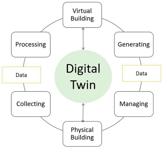
Figure 1.
Mechanisms of the digital twin framework: integration of virtual and physical building processes. Source: the author.
In addition to examining the benefits and drawbacks of heritage digital twins, this study investigates the use of 3D laser scanning, photogrammetry, and BIM technologies in the digital documentation of heritage architecture. It focuses on how well these technologies work to improve preservation and public accessibility.
Heritage conservation is essential for preserving cultural identities and historical narratives. Traditional methods often involve manual documentation, which can be time-consuming and prone to errors. The advent of Scan-to-CAD technology provides a digital solution that can greatly enhance the conservation process [14]. The precision of laser scanning is invaluable for documenting complex geometries that are difficult to measure manually, and this accuracy is a reliable foundation for restoration. Efforts related to heritage preservation take a lot of labor and time. Unfortunately, deteriorating materials, natural disasters like earthquakes, predatory tourism, acts of terrorism, and conflict threaten elements, monuments, and buildings deemed architectural heritage [7]. This calls for cooperation between stakeholders, subject matter specialists, and the larger community, as well as a thorough grasp of the legacy resource’s historical, cultural, and social value [15]. Digital cultural heritage preservation has recently focused on documenting cultural heritage using technology, particularly virtual heritage [16]; this can be seen in several examples. Fahmy addressed this concept by developing a digital twin for the city of Aga as a key aspect of a funded applied research initiative [17]. They used high-resolution photogrammetric triangulation 3D modeling generated by processing DJI-Zenmuse RGB camera aerial captures, measuring real geo-referenced areas and the distances of urban forms with less than 1 cm of error via photogrammetry, employing drones at low altitudes. Another example is a study conducted in the ancient town of Petra, where the rock-cut Al-Deir monument is famous for its impressive design and historical significance [18]. The study assessed and quantified damage to the Al-Deir monument, finding that 3D laser scanners were the most effective tool, as they accurately identified the damage areas and produced detailed 3D point clouds with RGB values. This facilitated the creation of a precise 3D model and provided valuable reference data, serving as a detailed guide for necessary restoration efforts [19].
M. Salim Ferwati and Sherine El Menshawy addressed a successful example of adopting 3D data acquisition technology to generate 3D models of the Colosseum in Rome [20]. This technology is divided into contact and non-contact methods: contact techniques require physical interaction with the object’s surface to gather precise data, and non-contact techniques involve photogrammetry, where the 3D coordinates of objects are determined by matching dense images captured from multiple angles using calibrated cameras. On 15 April 2019, a fire engulfed Notre Dame Cathedral in Paris, causing the spire to collapse onto the last two spans of the nave and destroying much of the timber roof above the vaulted ceilings [21]. Before the fire, historian Andrew Tallon conducted a detailed 3D laser scan of the cathedral. These data became the foundation for creating an accurate digital twin of the structure [22]. Although a modern structure, the Sydney Opera House is a UNESCO World Heritage Site and requires advanced maintenance solutions; by 2050, it is projected to experience a 0.090% element strain caused by creep and shrinkage, leading to prestress losses of 32.59 kN per strand. Thus, engineers created a digital twin using laser scans and building information modeling (BIM) data to capture the structure’s intricate geometry [23]. Pompeii, an ancient Roman city preserved under volcanic ash, is a UNESCO World Heritage Site requiring constant monitoring and preservation. Archeologists in Pompeii have utilized 2D and 3D models to reconstruct the ancient site, enabling extensive collaboration and real-time data sharing. Advanced GIS technology has replaced traditional handwritten notes and sketches, providing more accurate and reliable documentation. Using a digital twin allows researchers to revisit an excavation site virtually and conduct ongoing analyses of their discoveries [24]. This study applies a hybrid approach to the Khusru Pasha Sabil, focusing on mid-scale, community-integrated heritage and highlighting the adaptability of digital twin strategies across different conservation contexts.
This study will address similar contemporary methods for digitizing cultural heritage documentation for sustainable cultural and tourism enhancement. Our case study demonstrates the application of digital twin technologies in preserving Ottoman-era architectural and conservation challenges, providing new insights into compact heritage structures. Considering this, a DT platform’s structured and integrated data store could aid a heritage asset’s long-term conservation [18].
2. Materials and Methods
The Ottoman Empire dominated the Islamic world for roughly five centuries and was the most enduring Islamic empire in history [25]. Thus, it had a lasting and beneficial impact on Islamic societies in many aspects of life. Architecture symbolized the empire’s strength and the inventive spirit of its architects, playing a significant role in shaping the styles of Islamic communities. Egypt was similarly influenced under Ottoman control for approximately three centuries (from the 16th to the 18th century, 1517 AD to 1805 AD) [26]. The Ottoman-style buildings in Egypt highlight the architects’ direct and indirect architectural contributions and influences [27]. The Ottomans redefined cities by enriching them with monuments and institutions, meticulously recording, organizing, and glorifying the essence of urban life [28].
As shown in Figure 2, the Sabil of Khusru Pasha is a remarkable example of Ottoman architectural ingenuity and urban philanthropy in Historic Cairo. Built in 1535 AD (941 AH), during the early Ottoman rule of Egypt, this sabil was commissioned by Khusru Pasha, a governor who ruled the area under the Empire. It is situated on Al-Mu’izz Street, directly across from Sultan Qalawun’s complex as shown in Figure 3. It embodies the rich architectural style of the period and is recognized as the city’s oldest surviving Ottoman sabil (a kind of public fountain), reflecting the spiritual and practical values of Islamic culture. It was designed to provide free drinking water to the public, a highly virtuous charitable act in Islam. A dual purpose was characteristic of many sabils in Cairo, providing water to the public while functioning as educational spaces [29]. Khusru (Hüsrev) Pasha was among the most dedicated Ottoman governors when it came to architectural projects. He oversaw the construction of notable mosques in Diyarbakir (1519–1529), Sarajevo (1532), and Van (1567). His contributions extended to Aleppo, where he built a mosque and two madrasas (1546–1547) designed by the renowned architect Mimar Sinan [28]. Additionally, he commissioned a türbe (tomb) in Istanbul, a unique canopy-style mausoleum in Van (1581), and a caravanserai along the Van-Bitlis road, showcasing his commitment to enhancing religious and practical infrastructure [30].
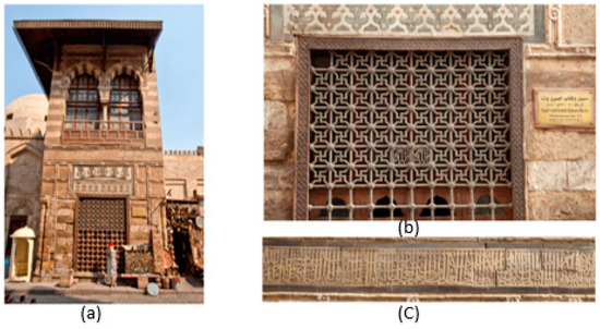
Figure 2.
(a) Northern south elevation of the Khusru Pasha Sabil and Kutab. (b) Window at the northern south elevation. (c) Inscriptions on the façade above the window. Source: Google Images.
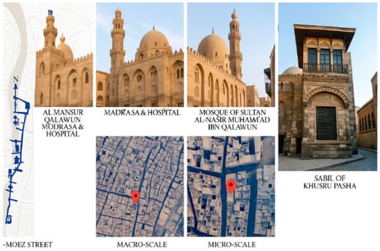
Figure 3.
Location of the Khusru Pasha Sabil. Source: the author.
Our profound and intangible connection to these historical layers and architectural cores stems from deep-seated belief and unwavering commitment. This connection is not merely the result of academic study; professional specialization; official duties; or even a fleeting interest in a collection of stones, floral and geometric patterns, or intricate wooden and copper star-shaped designs. Instead, it is a spiritual bond rooted in their humanity, natural essence, and spontaneity. This bond is even more significant because these structures stand as living testimonies, documenting and preserving the extraordinary and miraculous journey of urban development—whether residential, administrative, or religious. They are a timeless archive, narrating stories of creativity and innovation that transcend their physical components to reflect the spirit and ingenuity of the civilizations that built them. The architectural elements brought by the Ottomans and the dominant features and styles of Mamluk architecture combined to form a unique and original architectural style; these features can be defined as follows [31]:
- Ottoman-style stonework: the façade is adorned with geometric patterns and arabesque designs carved in stone, showcasing the meticulous craftsmanship of the period.
- Wrought-iron window grilles: the windows through which water was distributed are decorated with intricate ironwork, often incorporating floral and geometric motifs.
- Wooden mashrabiyas: parts of the sabil include wooden latticework (mashrabiya) that provides shade and ventilation, a hallmark of traditional Egyptian–Ottoman architecture.
- Arabic calligraphy: the sabil bears inscriptions in Ottoman Arabic script, which often includes verses from the Quran, praising the charitable act of providing water and invoking blessings upon the donor.
3. Methodology
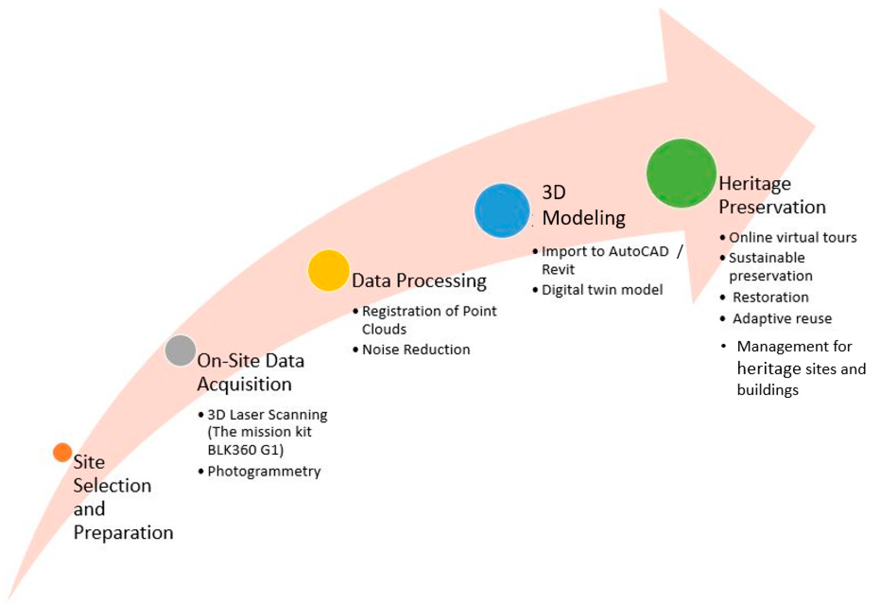
This study uses a multi-phase methodology to preserve architectural heritage. This involves preliminary research; on-site data collection using 3D laser scanning and photogrammetry; data processing and model generation using specialized tools; and analysis and application through the development of a digital twin for heritage conservation and virtual tourism. This workflow ensures high-resolution output and geometric accuracy but has limitations like dependency on optimal lighting conditions and computational demands.
The Sabil of Khusru Pasha, like many historic monuments in Cairo, has undergone periods of neglect and decay. However, with the growing interest in preserving Egypt’s heritage, some efforts have been made to restore it. Integrating Scan-to-BIM technology into heritage conservation practices presents significant advantages. By enhancing accuracy, facilitating comprehensive data capture, improving restoration processes, and increasing public engagement, this technology plays a crucial role in preserving our cultural heritage for future generations. However, it is not enough to comply with all the international charters and conventions for safeguarding and protecting heritage sites. Restoration projects often involve cleaning the stonework, reinforcing structural stability, and conserving decorative elements like inscriptions and ironwork. This subject necessitates dynamic documentation, assuring all SDG targets for heritage preservation, documentation, and renovation. Producing digital twin models in formats like AutoCAD 2023 or BIM for heritage sites, iconic buildings, or structures with distinctive characters is essential and a dimension that must be maintained. This method not only documents individual buildings or even entire urban fabrics but also markets sustainable architectural and urban design projects, particularly in areas with cultural tourism, historical urban layers, and important architectural artifacts.
This study adopts the DT methodology to preserve architectural heritage. To prove our hypothesis regarding digital documentation, the investigation and analysis rely on the digital documentation, direct observation, and photographic surveillance of the selected case study of the Khusru Pasha Sabil and Kutab. Thus, all photogrammetric and laser scanning can be integrated into the global Internet as a system for virtual tourism in urban heritage and historical areas (Urban Heritage Virtual Tourism). Users can visit their cities or explore other regions in a realistic and immersive manner. This approach brings these locations to life in a tangible way, resembling the experience of Siemens City on the outskirts of Berlin, Europe. Unlike traditional smart home applications that enable mobile phone control of air conditioning, lighting, refrigerators, or washing machines, this innovation represents a new frontier in smart cities, operated through digital twins. This study uses laser scanning for the heritage documentation of the Khusru Pasha Sabil, focusing on this technique’s ability to capture high-resolution geometric data and consistent point cloud density across complex surfaces. Laser scanning is crucial for narrow and shaded architectural environments and provides consistent point cloud density, while photogrammetry is sensitive to lighting and requires more post-processing. The hybrid approach shown in Figure 4 combines the strengths of both techniques for façade texture data.

Figure 4.
Scan-to-heritage preservation workflow. Source: the author.
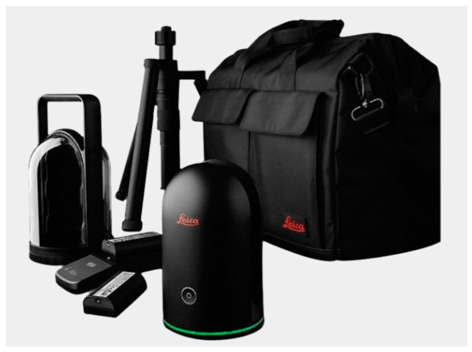
Moreover, this initiative breathes new life into a valuable cultural and historical artifact by combining virtual tourism with augmented reality online. This integration allows audiences from all over the world, whether near or far, to witness and engage with these experiences, offering them an endless and transformative journey. It redefines how we connect with heritage and history, making it accessible to everyone, regardless of location. A digital survey process was used over approximately 6 h on-site using a Mission Kit BLK360 G1 laser scanner Sourced from Leica Geosystems AG (Heerbrugg, Switzerland), which has a 360° field of view and can acquire high-resolution point clouds up to 60 m away. Each scan session took 3–5 min depending on complexity and environmental factors, as shown in Figure 5. The scanner has a scan resolution of up to 1 mm and an accuracy of within 4 mm at 10 m. To guarantee the best possible scan quality, environmental factors such as lighting and potential obstructions were considered. The Leica Cyclone mobile app streams image and point cloud data and was used for data processing. Point clouds offer high geometric fidelity suitable for heritage documentation. A total of 35 individual scan positions were registered and processed, yielding a dense point cloud of over 120 million points. Post-processing in Autodesk ReCap 2023 and AutoCAD required an additional 12 h, including noise reduction, registration, and model generation. These metrics demonstrate the efficiency and precision of the hybrid laser scanning and photogrammetry workflow adopted in this study. Following collection, the data were sent for registration and additional processing. After refinement, the point clouds were imported into Autodesk for AutoCAD modeling.

Figure 5.
Laser scan tool kit [32].
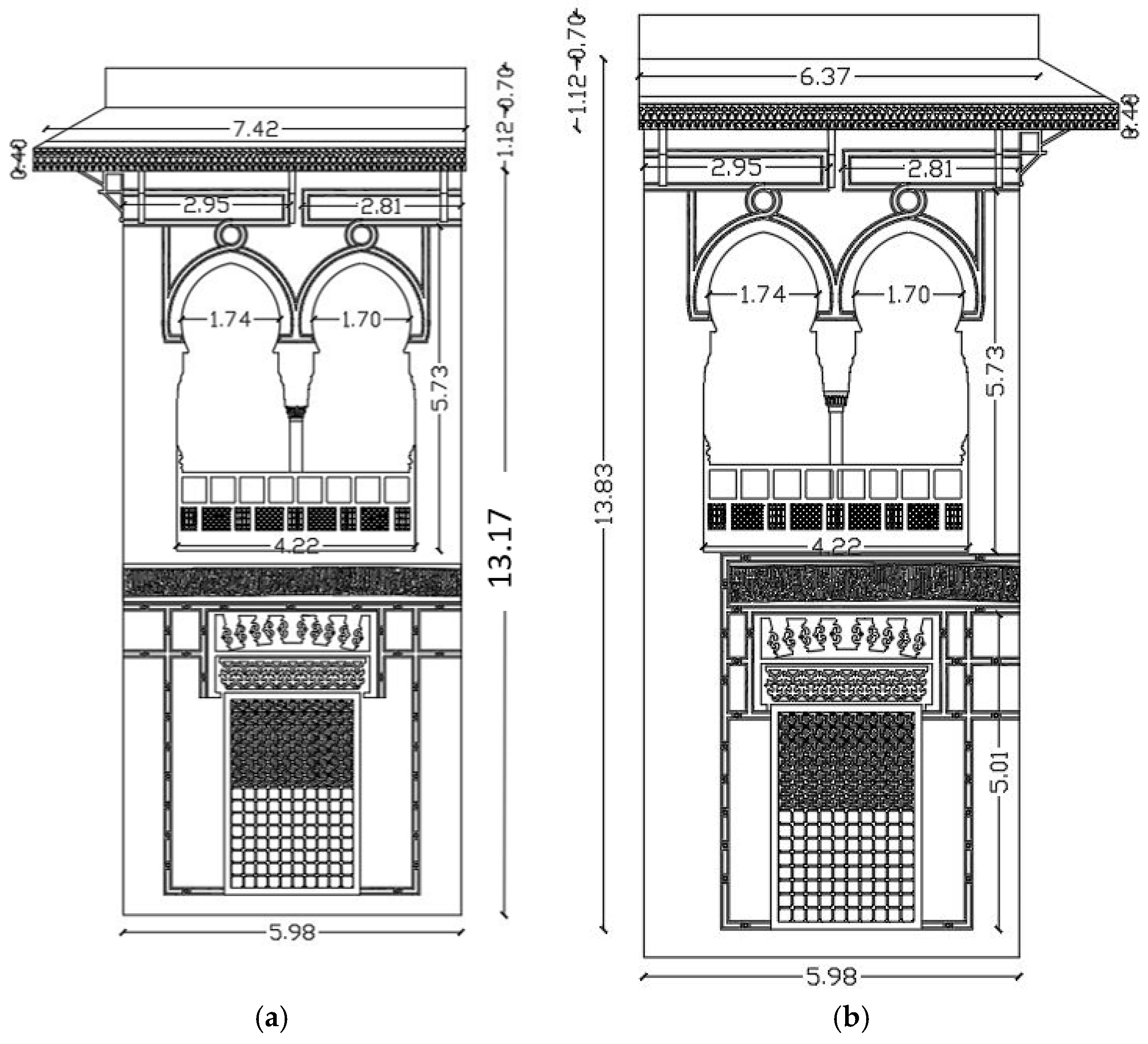
The previous examples indicate that qualitative strategies and inductive approaches can play a significant role in heritage preservation by utilizing virtual documentation, thus supporting sustainable conservation efforts. Additionally, this method enhances the marketing and management of heritage sites, promoting their long-term preservation and accessibility. The application of digital twin heritage conservation is reshaping how we document, preserve, and interact with historical sites. By improving accuracy, allowing for detailed data capture, streamlining restoration processes, and enhancing public access to cultural heritage, this technology not only aids in immediate preservation efforts but also contributes to the long-term sustainability of culturally significant sites. As heritage conservation continues to evolve in the digital age, Scan to BIM will likely enable deeper insights and more effective practices that honor our shared history. Figure 6 illustrates the initial processing, which includes laser scanning, photography, and AutoCAD for the Khusru Pasha Sabil and Kutab on Al-Mu’izz Street.

Figure 6.
(a) Main elevation with initial processing, including laser scanning, photography, and AutoCAD for the Khusru Pasha Sabil (water fountain) and Kutab on Al-Mu’izz Street. (b) Side elevation [33].
4. Discussion and Conclusions
Per previous studies, the application of digital twin technology in conserving and maintaining cultural heritage has opened new possibilities by repurposing historic buildings for modern uses and turning heritage sites into tourist hubs that boost the local economy [33]. Digital twins are 3D models generated by laser scanning existing buildings and urban structures, and this technology is especially significant for historical cities, as it enables the creation of detailed architectural drawings of original structures and designs. Furthermore, it facilitates the reconstruction of elements that may have been lost or damaged, as demonstrated by the restoration of France’s Notre Dame Cathedral. This is precisely what is currently taking place in Cairo, the core of Egypt’s historical architectural heritage. This study showcases a customized digital twin workflow, offering a practical model for digital preservation by examining an independent Ottoman sabil in Egypt. However, the digital twin methodology in cultural heritage conservation faces limitations, including complex historical geometries, material degradation, and spatial constraints. The process requires substantial computational resources and expertise, which may not be consistently available in all heritage contexts. Public access to digital heritage models also introduces challenges, such as data ownership and long-term platform maintenance. Recognizing these challenges is crucial for developing a more holistic and responsible approach. A digital twin’s long-term relevance relies on a structured update and maintenance strategy, including version control, regular resurveys, and stakeholder collaboration. This ensures the model remains a living, evolving representation of the physical structure. The crucial benefits of using digital twins for heritage sites are as follows:
- Precise preservation: preserving intricate details for future generations with high-resolution models.
- Proactive maintenance: monitoring conditions and predicting damage.
- Disaster recovery: providing blueprints for accurate reconstruction after damage.
- Virtual accessibility: enabling immersive virtual tours, making heritage accessible.
- Cultural preservation: helping communities maintain their cultural identity and pride.
Errors caused by inaccurate, incomplete, or uncoordinated information can significantly diminish the value and importance of historic assets. Traditional documentation methods struggle to address the complexity of historic buildings, which encompass diverse and intricate data [18]. In this regard, adopting a structured and integrated system, like digital twins, offers a promising solution to enhance and sustain the long-term conservation of these heritage sites. Smart governance for inherited physical assets using BIM digital twin models can not only enhance the documentation of a building or even entire urban fabrics but can also help in marketing urban heritage virtual tourism by linking it to the use of applied online virtual tours, mobile apps, web maps, and the smart management of heritage sites. To conclude, digitizing heritage via laser scanning and photogrammetry for IBIM (integrated building information modeling) is important for preserving heritage touristic monuments, marketing tourism, sharing and conserving materials for accessibility, and preserving physical assets. Future research will expand this digital twin framework to Islamic Cairo’s heritage assets; develop AI-integrated platforms for material degradation prediction; enhance public engagement through VR and AR; and collaborate with local authorities for policymaking and sustainable tourism development. Real-time monitoring sensors could also enhance conservation and maintenance planning.
Funding
This research received no external funding.
Data Availability Statement
Data are contained within the article.
Acknowledgments
The author gratefully acknowledges Prince Sultan University, Research Initiative Center RIC for covering the Article Processing Charges (APC) and providing financial incentives.
Conflicts of Interest
The author declares no conflict of interest.
References
- Yeomans, R. The Art and Architecture of Islamic Cairo; Garnet Publishing Limited: Reading, UK, 2006. [Google Scholar]
- UNESCO. Text of the Convention for the Safeguarding of Intangible Cultural Heritage; UNESCO: Paris, France, 2009. [Google Scholar]
- UNESCO. Basic Texts of the 2003 Convention for the Safeguarding of the Intangible Cultural Heritage; UNESCO: Paris, France, 2024. [Google Scholar]
- United Nations Department of Economic and Social Affairs. Goals_2015, United Nations_Goals_Sustainble Development; United Nations: New York, NY, USA, 2015. [Google Scholar]
- Omer, M.A.; Noguchi, T. A conceptual framework for understanding the contribution of building materials in the achievement of Sustainable Development Goals (SDGs). Sustain. Cities Soc. 2020, 52, 101869. [Google Scholar] [CrossRef]
- Lynch, J.; Parcero-Oubiña, C.; Fábrega-Álvarez, P. A field experience of documentation and analysis through 3D mapping and surface survey in the Hualfín Valley (Catamarca, Argentina). Digit. Appl. Archaeol. Cult. Heritage 2020, 17, e00145. [Google Scholar] [CrossRef]
- Roberto Bartholo, A.B. Toward a Digital Twin for Cultural Heritage, in Smart Innovationm, Systems and Technology; Springer: Berlin/Heidelberg, Germany, 2023. [Google Scholar]
- James Hutson, J.W.; Angela, R. Digital Twins and Cultural Heritage Preservation: A Case Study of Best Practices and Reproducibility in Chiesa dei SS Apostoli e Biagio. Res. Sq. 2023, 11, 15–41. [Google Scholar]
- Bolton, A.L.B.; Dabson, I.; Enzer, M.; Evans, M.; Fenemore, T.; Harradence, F.; Keaney, E.; Kemp, A.; Luck, A.; Pawsey, S.S.; et al. The Gemini Principles: Guiding Values for the National Digital Twin and Information Management Framework; Centre for Digital Built Britain: Cambridge, UK, 2018. [Google Scholar]
- Niccolucci, F.; Felicetti, A. Digital Twin sensors in cultural heritage applications. Sensors 2024, 24, 3978. [Google Scholar] [CrossRef] [PubMed]
- European Commission. Commission Recommendation (EU) 2021/1970 of 10 November 2021 on a Common European Data Space for Cultural Heritage; Official Journal of the European Union: Luxembourg, 2021. [Google Scholar]
- Andres Sebastian, C.C.; Muhyiddine, J. A review of building digital twins to improve energy efficiency in the building operational stage. Energy Inform. 2024, 7, 11. [Google Scholar]
- Bortolini, R.; Rodrigues, R.; Alavi, H.; Vecchia, L.F.D.; Forcada, N. Digital twins’ applications for building energy efficiency: A review. Energies 2022, 15, 7002. [Google Scholar] [CrossRef]
- Barsanti, S.G.; Caruso, G.; Micoli, L.L.; Rodriguez, M.C.; Guidi, G. 3D Visualization of Cultural Heritage Artefacts with Virtual Reality devices. In Proceedings of the 25th International CIPA Symposium, Taipei, Taiwan, 31 August–4 September 2015. [Google Scholar]
- Jokilehto, J. A History of Architectural Conservation; Routledge: London, UK, 2017. [Google Scholar]
- Yehuda Kalay, T.K.; Janice, A. New Heritage: New Media and Cultural Heritage; Routledge: London, UK, 2007. [Google Scholar]
- Mohamad Fahmy, S.M.; Mahmoud, S.; Saad, M.M.; Abdelalim, M.; Safwat, I.; Abdelkhalik, H. Assessing the Microclimate and Mitigation Effects of Courtyards in the 5th Generation Egyptian Cities Design Manifesto: A Case Study in Aga, Egypt. In Environmental Science and Engineering; Springer: Berlin/Heidelberg, Germany, 2024; pp. 235–250. [Google Scholar]
- Walaa Hamed, A.E.A. Knowledge-based HBIM for conservation: The case of Yahya al-Shabih mausoleum. Digit. Appl. Archaeol. Cult. Herit. 2023, 30, e00278. [Google Scholar]
- Alshawabkeh, Y.; El-Khalili, M.; Almasri, E.; Bala’awi, F.; Al-Massarweh, A. Heritage documentation using laser scanner and photogrammetry. The case study of Qasr Al-Abidit, Jordan. Digit. Appl. Archaeol. Cult. Heritage 2020, 16, e00133. [Google Scholar]
- Gaiani, M.; Balzani, M.; Uccelli, F. Reshaping the Coliseum in Rome: An integrated data capture and modeling method at heritage sites. Comput. Graph. Forum 2000, 19, 369–378. [Google Scholar] [CrossRef]
- Antoine Gros, A.G.; De Luca, L.; Baillieul, É.; Duvocelle, B.; Malavergne, O.; Leroux, L.; Zimmer, T. Faceting the post-disaster built heritage reconstruction process within the digital twin framework for Notre-Dame de Paris. Sci. Rep. 2023, 13, 5981. [Google Scholar]
- Keskeys, P. How One Man’s Legacy Could Help Rebuild Notre-Dame Cathedral Andrew Tallon’s Pioneering Analysis of the Past Could Hold the Key to the Future of Notre-Dame; Architizer: New York, NY, USA, 2020. [Google Scholar]
- Faham Tahmasebinia, D.F.; Wu, L.O.; Li, Z.; Sepasgozar, S.M.E.; Zhang, K.; Sepasgozar, S. Numerical Analysis of the Creep and Shrinkage Experienced in the Sydney Opera House and the Rise of Digital Twin as Future Monitoring Technology. Buildings 2019, 9, 137. [Google Scholar] [CrossRef]
- Staff, E. GIS, 3D models and Digital Twins for the Archaeology of Pompeii, in Geosmart; GIM International: Milan, Italy, 2023. [Google Scholar]
- Fawzani, N.; Sulaeman, I.; Mizan, K.; Muhlis, W.; Mubaraq, Z. History of Islamic Calligraphy in the Ottoman Empire Era. Fajar Hist. J. Ilmu Sej. dan Pendidik. 2023, 7, 35–47. [Google Scholar] [CrossRef]
- Khesro Pasha Sabil and Kutab. Available online: https://islamic.cultnat.org/Object?ID=50&Src=Mon (accessed on 23 April 2025).
- Abdelsalam, T. Sinan’s Architecture as A Source of Inspiration in Mosque Design in Egypt from 16th to 19th Century: Three Different Approaches. Encycl. Islam. Archit. Egypt 2010, 2, 13. [Google Scholar]
- Watenpaugh, H. The Image of an Ottoman City, Imperial Architecture and Urban Experience in Aleppo in the 16th and 17th Centuries; The Ottoman Empire and its Heritage; Brill: Leiden, The Netherland, 2004; Volume 33. [Google Scholar]
- Sabri Jarrar, A.R.; Spurr, J.B. Resources for the Study of Islamic Architecture-Historical Section; Aga Khan Program for Islamic Architecture: Cairo, Egypt, 1994; p. 382. [Google Scholar]
- Raymond, A. The Great Arab Cities in the 16th–18th Centuries: An introduction. Int. J. Middle East Stud. 1984, 21, 411–412. [Google Scholar]
- Rabbat, N. “Perception of Architecture in Mamluk Sources”, Mamluk Studies “Architects and Artists in Mamluk Society: The Perspective of the Sources”. J. Archit. Educ. 2002, 52, 30–37. [Google Scholar]
- BLK, g. 2025. Available online: https://shop.leica-geosystems.com/it/it-IT/leica-blk/blk360/overview?srsltid=AfmBOooHRIN3-4MJY-DW5jBi7ojA1ZWNOrYdVwnXAVjxxePt4CwNeoMo (accessed on 23 April 2025).
- Dias Pereira, L.; Tavares, V.; Soares, N. Up-to-date challenges for the conservation, rehabilitation and energy retrofitting of higher education cultural heritage buildings. Sustainability 2021, 13, 2061. [Google Scholar] [CrossRef]


Disclaimer/Publisher’s Note: The statements, opinions and data contained in all publications are solely those of the individual author(s) and contributor(s) and not of MDPI and/or the editor(s). MDPI and/or the editor(s) disclaim responsibility for any injury to people or property resulting from any ideas, methods, instructions or products referred to in the content. |
© 2025 by the author. Licensee MDPI, Basel, Switzerland. This article is an open access article distributed under the terms and conditions of the Creative Commons Attribution (CC BY) license (https://creativecommons.org/licenses/by/4.0/).