Article

Framing the Residential Patterns of Asian Communities in Three Italian Cities: Evidence from Milan, Rome, and Naples

1
Department of Economics and Business, University of Catania, 95129 Catania, Italy
2
Department of Political Sciences, University of Naples Federico II, 80133 Naples, Italy
*
Author to whom correspondence should be addressed.
Soc. Sci. 2023, 12(9), 480; https://doi.org/10.3390/socsci12090480
Submission received: 29 June 2023 / Revised: 13 August 2023 / Accepted: 18 August 2023 / Published: 29 August 2023

Abstract

:
Today, the interplay between economic inequality, international migration, and urban transformation has raised awareness about segregation and its social implications on a global and European scale. As cities become home to diverse populations with various backgrounds including social, racial, ethnic, and cultural, the proximity of these groups becomes more pronounced. This article explores the residential segregation of four Asian immigrant groups in three major Italian cities: Milan, Rome, and Naples. Using data from the 2011 Italian General Population Census and employing an areal weighted interpolation procedure, the study measures segregation using both traditional two-group indices and multi-group indices that account for the complexities of contemporary societies. The results indicate a north–south disparity, with Naples exhibiting the highest levels of residential segregation. Among the analysed immigrant groups, Bangladeshis and Chinese tended to be more self-segregated, while Filipinos and Sri Lankans were relatively more dispersed. This research underscores the necessity for a nuanced understanding of segregation dynamics and the adoption of appropriate approaches to address the challenges and opportunities presented by the coexistence of diverse groups in urban areas. By contributing to the existing literature on residential segregation in Southern Europe, this study sheds light on the spatial patterns and social dynamics of different ethnic groups in Italian cities.

1. Introduction

The interplay between economic inequality, international migration, and urban transformation has sparked renewed attention to the issue of segregation and imbued questions of socio-spatial separation and interaction with heightened social significance (van Ham et al. 2021; Piekut et al. 2019), raising the concern of national and international actors (OECD 2018). The process is significantly influenced by migration, which plays a fundamental role in shaping the socio-spatial structures of contemporary urban and metropolitan areas as well as influencing demographic dynamics in host societies (Benassi et al. 2020b; Portes 2000; Strozza et al. 2016). As international migration volumes and patterns have evolved, there has been a notable rise in the concentration of migrants in specific geographic areas, coinciding with the global trend of increasing urbanisation (Piekut et al. 2019). According to the most updated World Bank figures1, cities are home to approximately 56% of the global population, equivalent to 4.4 billion individuals. This pattern of urbanisation is projected to persist and grow in the next decades. In numerous countries, this has led to a situation where populations from increasingly diverse social, racial, ethnic, linguistic, and cultural backgrounds are being brought into closer proximity than ever before.
Residential segregation of ethnic groups has emerged as a significant concern in many European countries and cities. In some contexts, there is fear that segregation may hinder integration, while in others, there are concerns about xenophobic reactions towards ethnic minorities from parts of the population (Musterd and Fullaondo 2008). Since the late 1980s, international migration flows have shifted relatively from Western to Southern European countries and metropolises, fundamentally transforming the European migration map (Carella and Pace 2001; King 2002, 1993). Immigration flows have continued to grow over the most recent decades, especially in Southern European regions. In fact, since the 1990s, countries such as Italy, Spain, and Greece have emerged as the main destination for immigrants seeking to reach Europe (Livi Bacci 2007; Pugliese 2006; Strozza 2010). This, coupled with the rise in social and economic inequalities, fuelled by the 2008 economic crisis and the ongoing pandemic, has further solidified social, economic, and residential segregation in southern urban areas (Allen et al. 2004; Musterd et al. 2015; Tammaru et al. 2016; Benassi and Iglesias-Pascual 2022).
Cities in Southern Europe have experienced rapid diversification, although their segregation patterns may not necessarily follow the same trajectory as those in Northern Europe. Extensive literature highlights the different patterns of segregation in cities in Northern and Southern Europe (Malheiros 2002; King 2002, 1993). Just as some authors argue against applying American segregation models to Western European cities (Van Kempen and Özüekren 1998; Musterd 2005; Wacquant 2007), other scholars have proposed an original ethnic segregation model for Southern European cities as distinct from Western European models (Malheiros 2002; Arbaci 2007, 2004). While studies on residential segregation and spatial inequalities in Southern Europe already exist (Arbaci 2008; Benassi et al. 2020b; Tammaru et al. 2017), recent years have seen an increase in the levels of residential segregation and inequalities, which has reduced the gap between the south and north (Panori et al. 2019; Benassi et al. 2020a, 2023a). Simultaneously, there has been a rise in poverty levels and social vulnerability (Arapoglou 2012).
Although there are fewer contributions focused on the Italian context compared to the ones regarding Northern Europe, the relevance of this topic has been rapidly increasing, leading to a growing number of analyses (Benassi et al. 2023b, 2019; Bitonti et al. 2023; Busetta et al. 2015; Mazza et al. 2018; Mazza and Punzo 2016; Petsimeris and Rimoldi 2015; Rimoldi and Terzera 2017). Overall, these studies have revealed a spatial dichotomy at the macro level between the northern and southern parts of Italy, with Northern Italy exhibiting a higher proportion of immigrants and experiencing lower levels of residential segregation and inequalities.
Given the increasing complexity and diversity of contemporary Italian urban contexts, which are becoming more and more multicultural, the work aims to provide the segregation configuration in 2011 of three major Italian cities, Milan, Rome, and Naples, representing the situation in the north, centre, and south of the country, respectively. Apart from being the most important cities of each geographical Italian macro-areas, Milan, Rome, and Naples also represent three different socioeconomic contexts emerging as a consequence of the long-lasting north–south Italian divide. In short, the centre–north has traditionally been more prosperous and industrialised compared to the south. This advantage has indeed allowed the former to attract foreign immigrants for a relatively longer time compared to the south. For this reason, we believe that the assessment of possible between-city variations in segregation could encourage the critical thinking of the implications of macro-level dynamics on the immigrants’ residential allocation choices. Furthermore, the comparative approach implemented here allows the present work to cope with the scarcity of segregation studies (e.g., Benassi et al. 2023b), performing comparative analyses across Italian cities. The basic reasoning is to analyse several dimensions of segregation starting with the traditional separation between the dominant group (i.e., Italians) and the minority ones (the main immigrant groups residing in the areas), and then moving to the analysis of multi-group separation and interaction in the perspective of a growing “super-diversity” of the society. Super-diversity, as emphasised by Vertovec (2007) in its application to Britain and Wessendorf (2014) focussing on London, challenges traditional approaches to understanding and addressing segregation. It emphasises the need to move beyond binary notions of “us versus them” and recognises the intricacies and fluidity of interactions among diverse groups. This framework acknowledges that patterns of segregation can vary significantly, with different groups experiencing distinct forms of spatial separation or integration and, in our thoughts, represents a suitable approach to cope with the actual challenges and opportunities arising from the coexistence of numerous diverse groups within a given urban area (i.e., the high level of ethnic diversity that is typical of contemporary urban societies). Our reasoning draws upon the recent literature suggesting that two-group indices are inadequate for capturing the complexities of contemporary societies, which consist of multiple population groups differing in ethnicity, race, religion, and citizenship, residing within the same context (Kramer and Kramer 2019; Olteanu et al. 2019; Reardon and Firebaugh 2002; Sturgis et al. 2014).
The four Asian immigrant groups analysed were Bangladeshis, Chinese, Filipinos, and Sri Lankans. We believe that the analysis of their residential models is of particular interest firstly because their presence in the country highlights the global dimension (given the distance between Italy and their countries of origin) that immigration flows towards Italy have reached through time due to the globalisation of migration Secondly, to the best of our knowledge, no other works have comparatively studied these groups across different Italian urban contexts (apart from Benassi et al. (2023b) for Sri Lankans). Here, we intend to fill this gap in the literature by critically comparing segregation patterns both across immigrant groups and urban areas. Despite coming from the same continent, they present very different and peculiar characteristics both in relation to the type of settlement model and to their immigration tradition in Italy. For example, the Filipinos are a long-established community in Italy and present a model of urban settlement (i.e., they are mostly concentrated in Milan and Rome) and labour dominance (they usually work as domestic workers for wealthy Italian families). The original Pilipino incoming wave to Italy was predominantly composed of women and, in any case, it did not involve family movements. Nevertheless, the ones already settled in Italy have implemented family reunification practices. The Chinese, on the other hand, are a group of relatively more recent immigration. They follow a family-based migration form with a high rate of self-employment, especially in the service sector, trade, and catering. Their distribution has been defined as “clustered dispersed” because they tend to follow a point distribution. Bangladeshis and Sri Lankans are communities of more recent settlement. They are generally communities in which only males migrate for work reasons. They are usually employed in the catering and service sectors with no self-employment profiles. They are communities with highly concentrated territorial distributions in Italy, often with high levels of residential segregation. Sri Lankans also work as care givers and housekeepers in Italian households.
The remainder of the paper is set out as follows. We begin by presenting the data and urban contexts analysed. We then illustrate the methodology implemented to homogenise geographies and assess the different types of segregation for each city. Next, we set out the results and conclude with a consideration of the implications of our findings for our understanding of whether and how the ethnic composition of neighbourhoods varies and is affected by the various urban structures.

2. Materials and Methods

2.1. Population Data and Geographical Areas of Interest

The analysis included all the Sri Lankan, Bangladeshi, Chinese, and Filipino citizens holders of a regular residence permit and that were counted during the Italian General Population Censuses in 2001, 2011, and 20212. As reported in Table 1, over time, all of these groups have increased in absolute values in each city. As for 2021 in Milan, the presence of Chinese and Filipinos was high both in terms of their relative proportions to the total foreign population living in the city and compared to the total number of the same nationalities residing in the country, with Filipinos accounting for almost a quarter of the whole Filipinos registered in Italy. Filipinos and Bangladeshis amounted to a high share of the foreign population present in Rome, with the former accounting for about a fourth of the total number of Filipinos and the latter for over a quarter of the total Bangladeshis living in the country. Although Naples hosts fewer foreigners compared to Rome and Milan, the city is one of the preferred destinations for Sri Lankans. Indeed, the group has considerably increased over time, and in 2021, accounted for over a quarter of the total foreign population living in Naples and for the 13.2% of all Sri Lankans that have settled in Italy. Overall, despite the different migration history of each immigrant group, in 2021, the three cities together hosted 28.4%, 17.4%, 48.9%, and 35.6% of Bangladeshis, Chinese, Filipinos, and Sri Lankans, respectively, residing across the whole country. Their spatial arrangement in three Italian cities (namely Milan in the north, Rome in the centre, and Naples in the south of Italy) was plotted against the total resident population and total foreign resident population per census tract, alternatively, on the maps collected in Appendix A. The visualisation of the residential allocation patterns highlights a growing segregation from north to south for all the groups considered. Specifically in Milan, Filipinos and Sri Lankans appear more dispersed across the urban area with respect to Bangladeshis and Chinese, whereas they tend to progressively segregate in specific neighbourhoods in Rome and Naples, as the other immigrant communities.

2.2. Homogenising Geographies

The analysed population data coming from the Italian General Population Census in 2011 refer to the census enumeration areas (representing the smallest spatial units at which the Italian National Official Statistics Institute (Istat) in Milan, Rome, and Naples. The use of these arbitrary reporting zones poses a challenge known as the modifiable areal unit problem (Openshaw 1984; Openshaw and Taylor 1979). This problem arises because the results of spatial analysis are influenced by the scales and methods used to define the areal units. To address this issue and enable comparison among municipalities, we employed an areal weighted interpolation procedure. This procedure, known as one of the most common forms of spatial basis change for socioeconomic data, transfers data from one set of reporting zones (referred to as “source”) to another independent set (referred to as “target”) (Goodchild et al. 1993). In our case, we redistributed the census tract-based data onto a uniform spatial grid composed of cells measuring 100 by 100 m. This interpolation was carried out using the aw_interpolate() function from the areal R package (Prener and Revord 2019; R Core Team 2023).
The choice of a 100 m grid cell size, although arbitrary like any other cell size, has become a standard in the recent literature on residential segregation and settlement models of migrant populations. This choice is supported by the D4I Data Challenge on “Integration of Migrants in Cities”, organised by the European Commission-Joint Research Centre (JRC). The D4I dataset provides researchers worldwide with population distribution grids consisting of 100 m grid cells for cities in eight EU Member States3. Many studies have utilised the D4I dataset to gain comparable insights into migrant settlement patterns across various urban contexts (Benassi et al. 2023a, 2020a, 2020b; Marcińczak et al. 2021; Olteanu et al. 2020).
For each intersected feature i, which represents the overlap between the source feature (such as a census tract) and the target feature (a 100 by 100-m cell), we assigned an areal weight. This was used to quantify the contribution of the source feature to the target feature and is defined as:
W i = A i A j ,
where A i is the area of the intersected feature i and A j is the total area of the source feature j. We then estimated the share of the population data relating to the intersected feature as:
E i = V i W i ,
where E i is the estimated value for intersected feature I, V i is the population (or OMI) value for source feature j, and W i is the areal weight for intersected feature i. Finally, we summarised the data based on the target feature identification number through summation:
G k = E i k ,
where G k is the sum of all estimated values for target feature k and E i k is the estimated value from intersected features in i within target feature k. At the end of the areal weighted interpolation procedure, the census data referring to the enumeration areas are now rearranged and refer to a uniform spatial grid composed by cells of 100 by 100-m side.

2.3. Measuring Residential Segregation
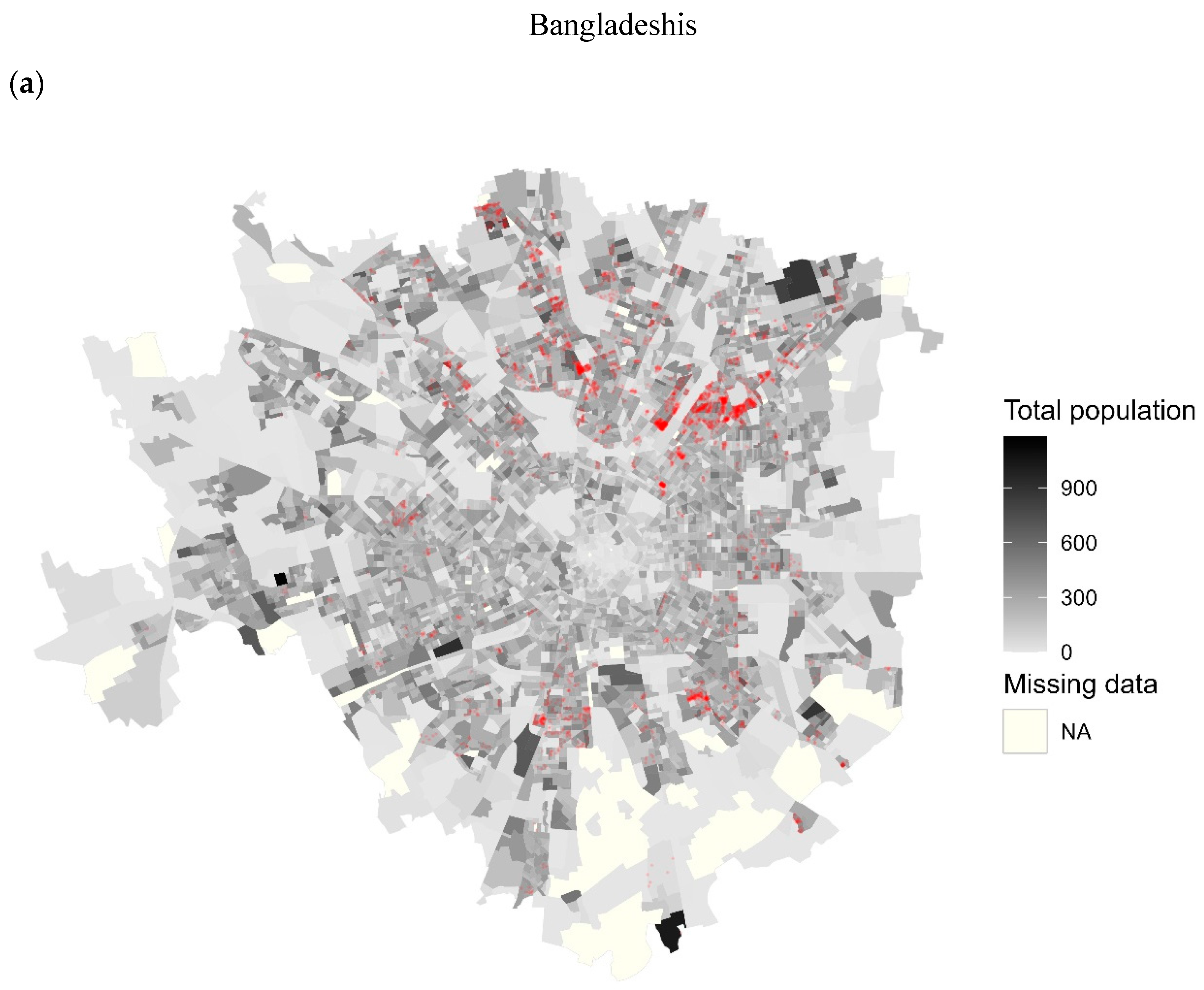
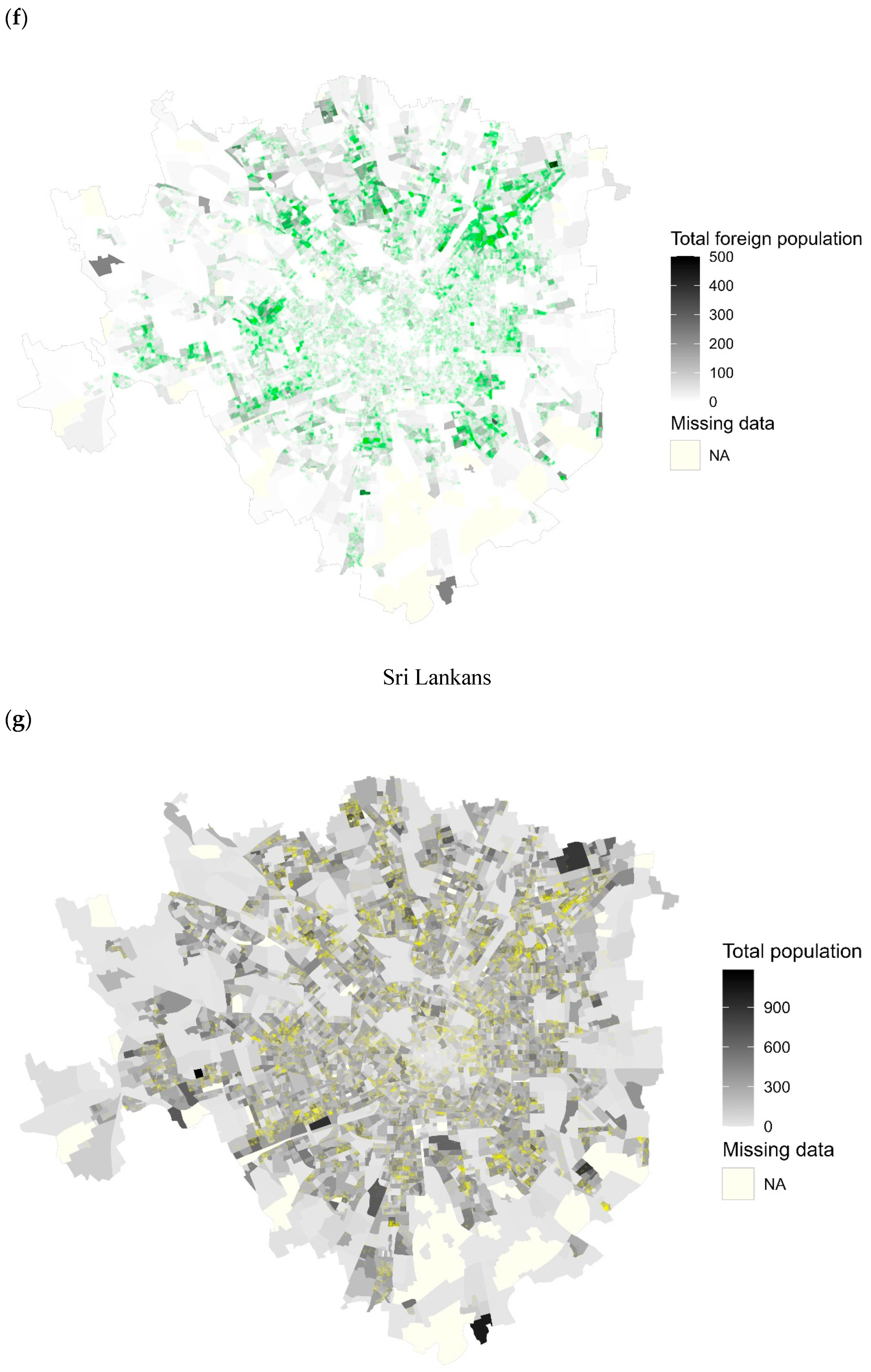
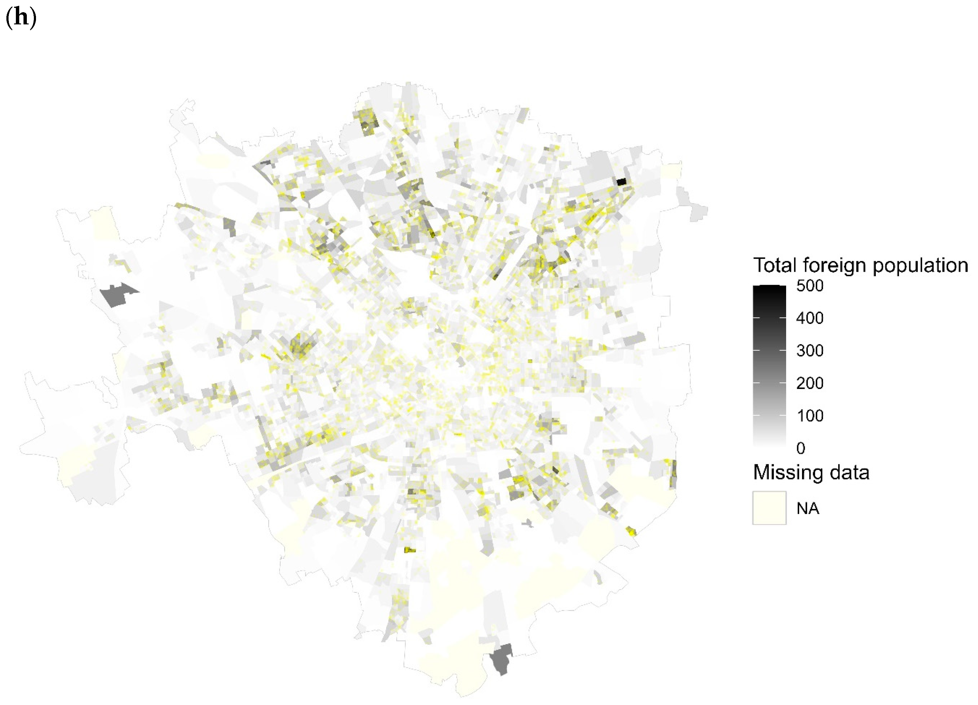
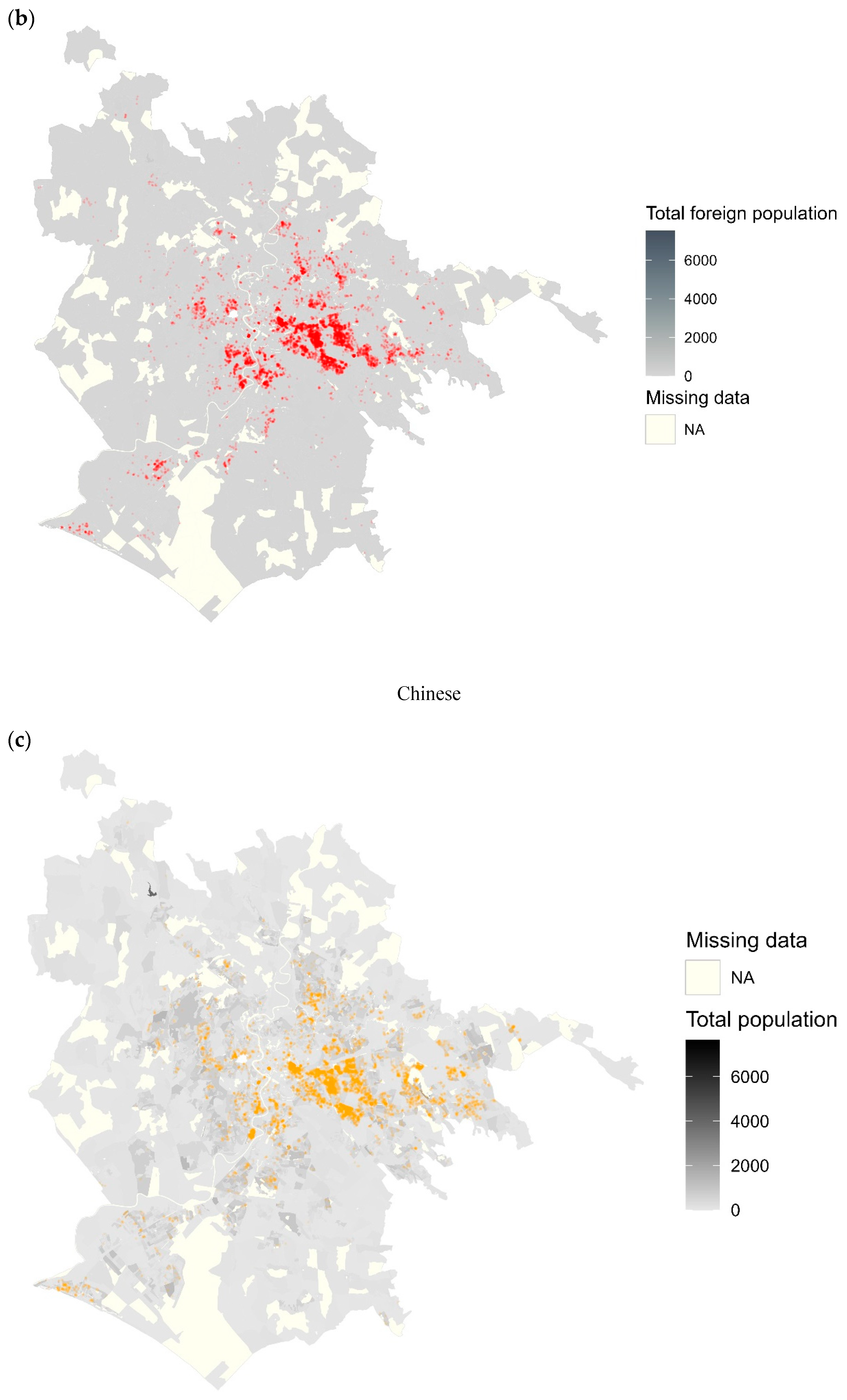
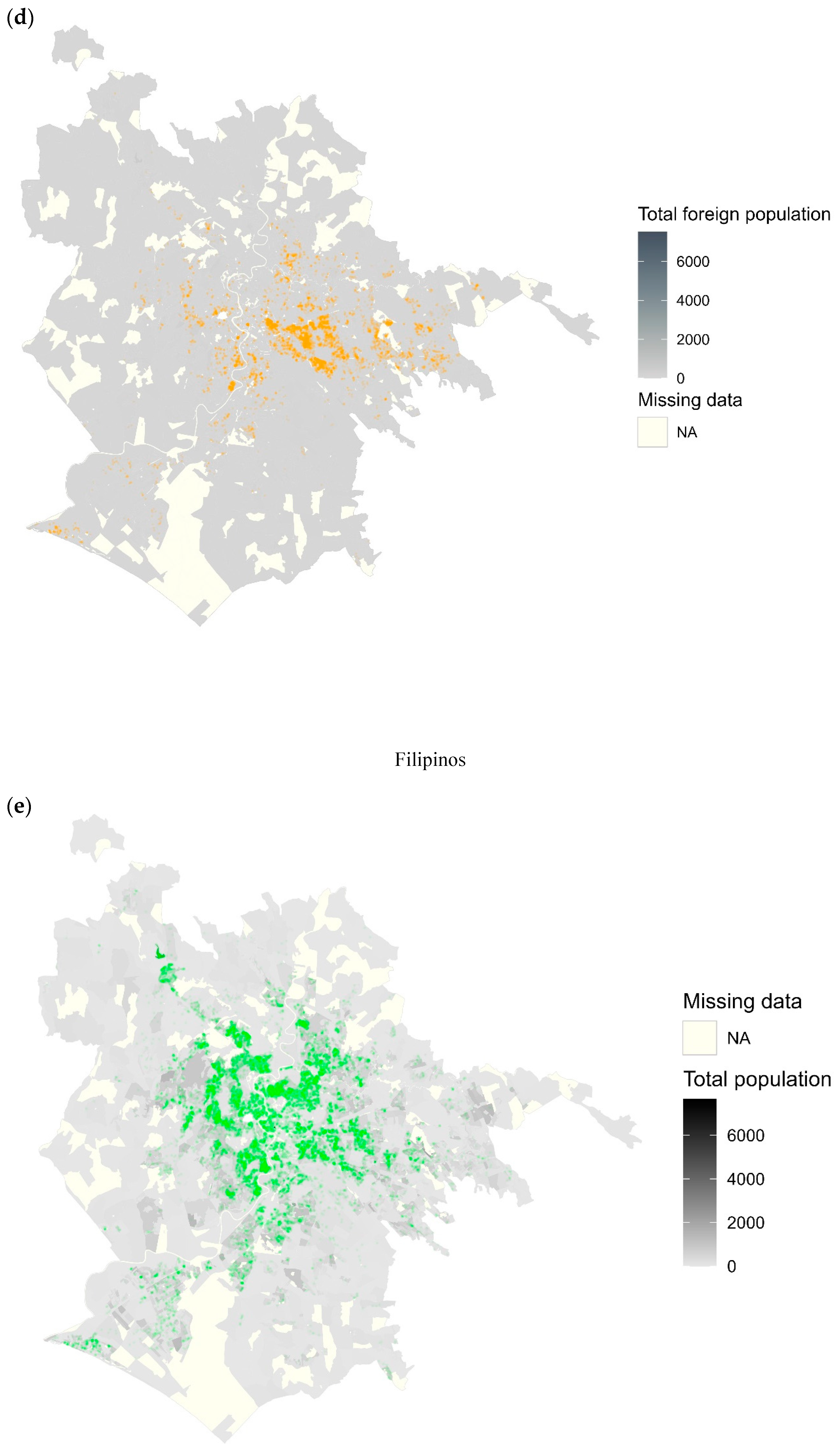
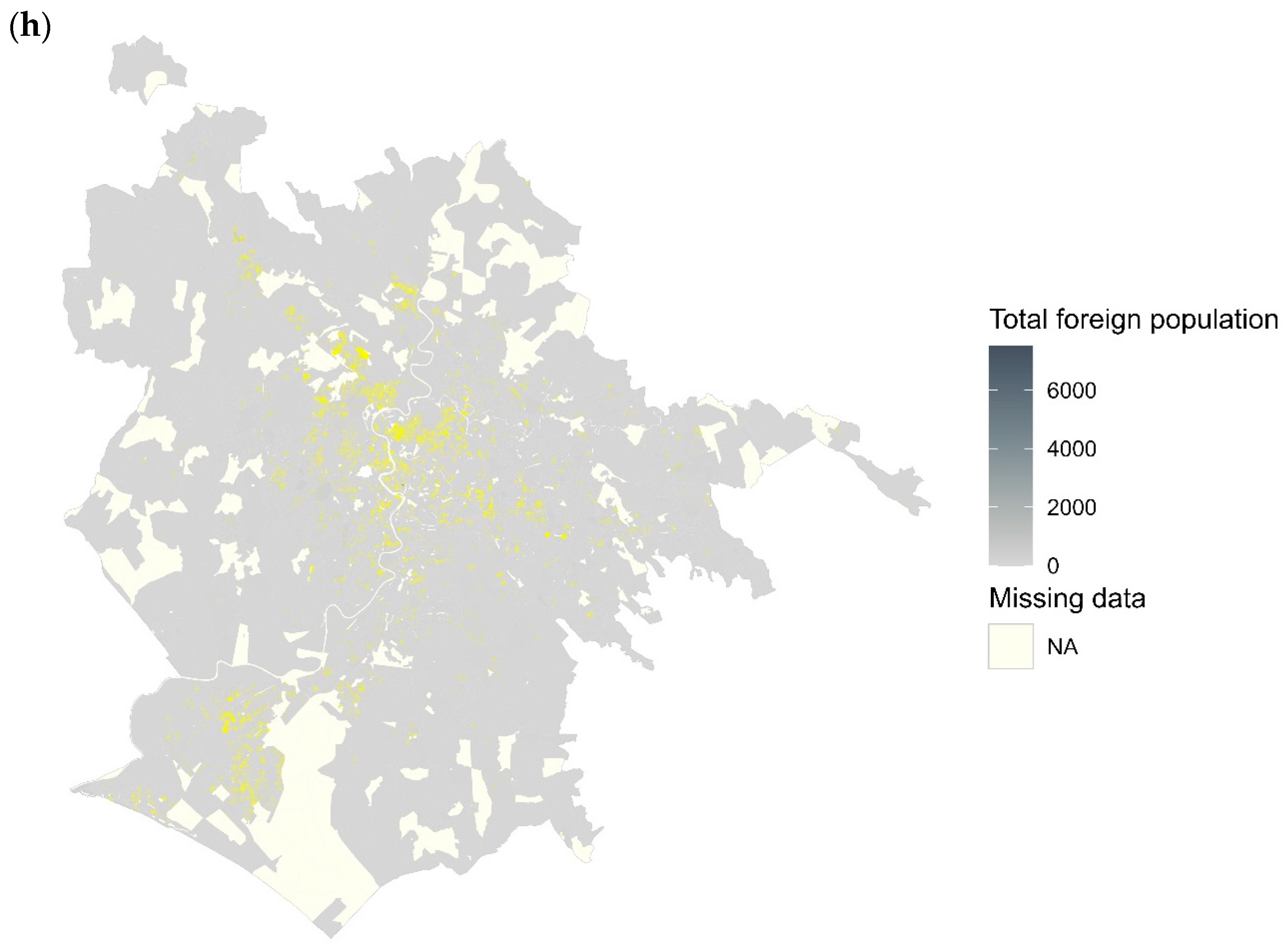
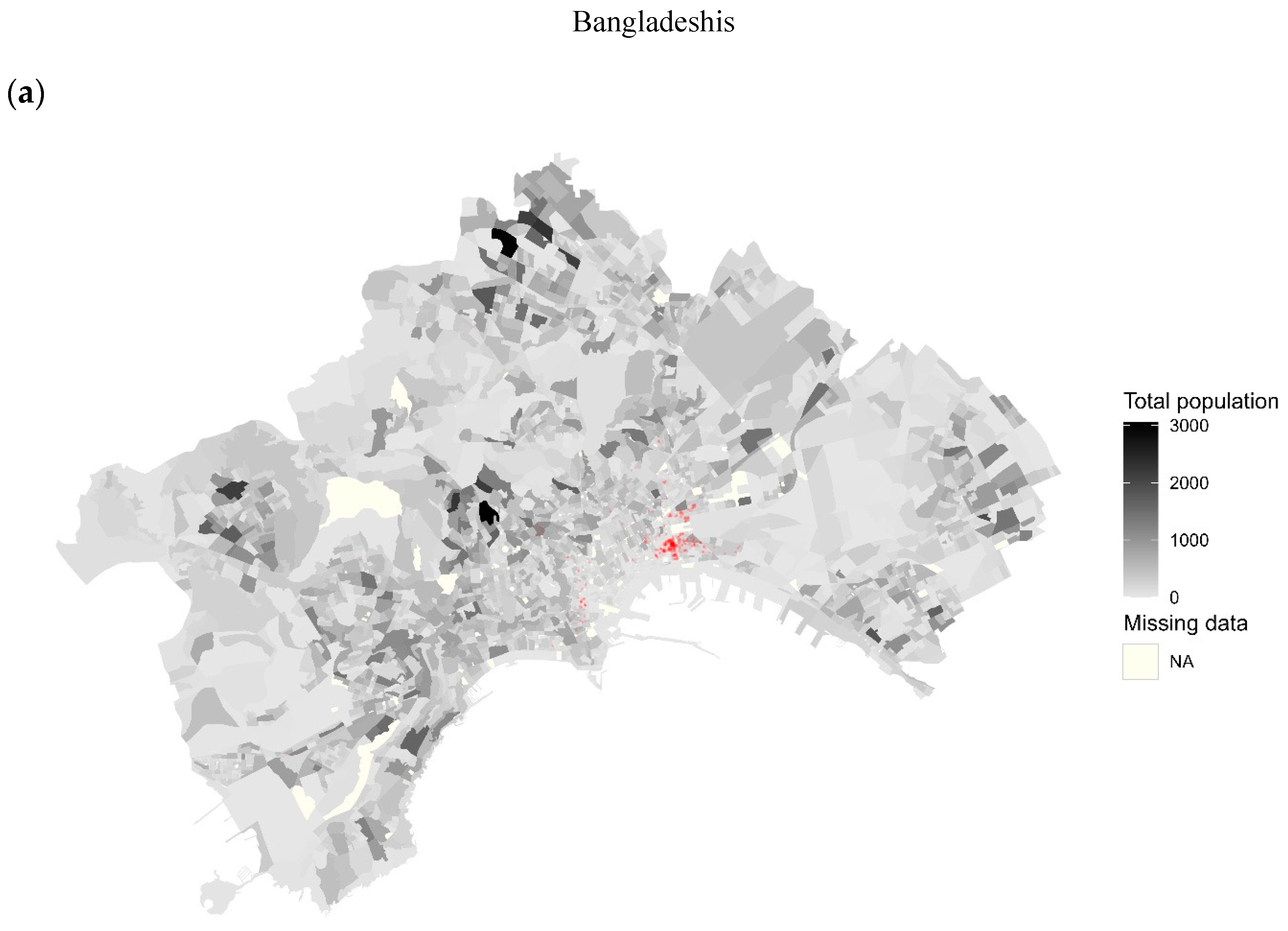
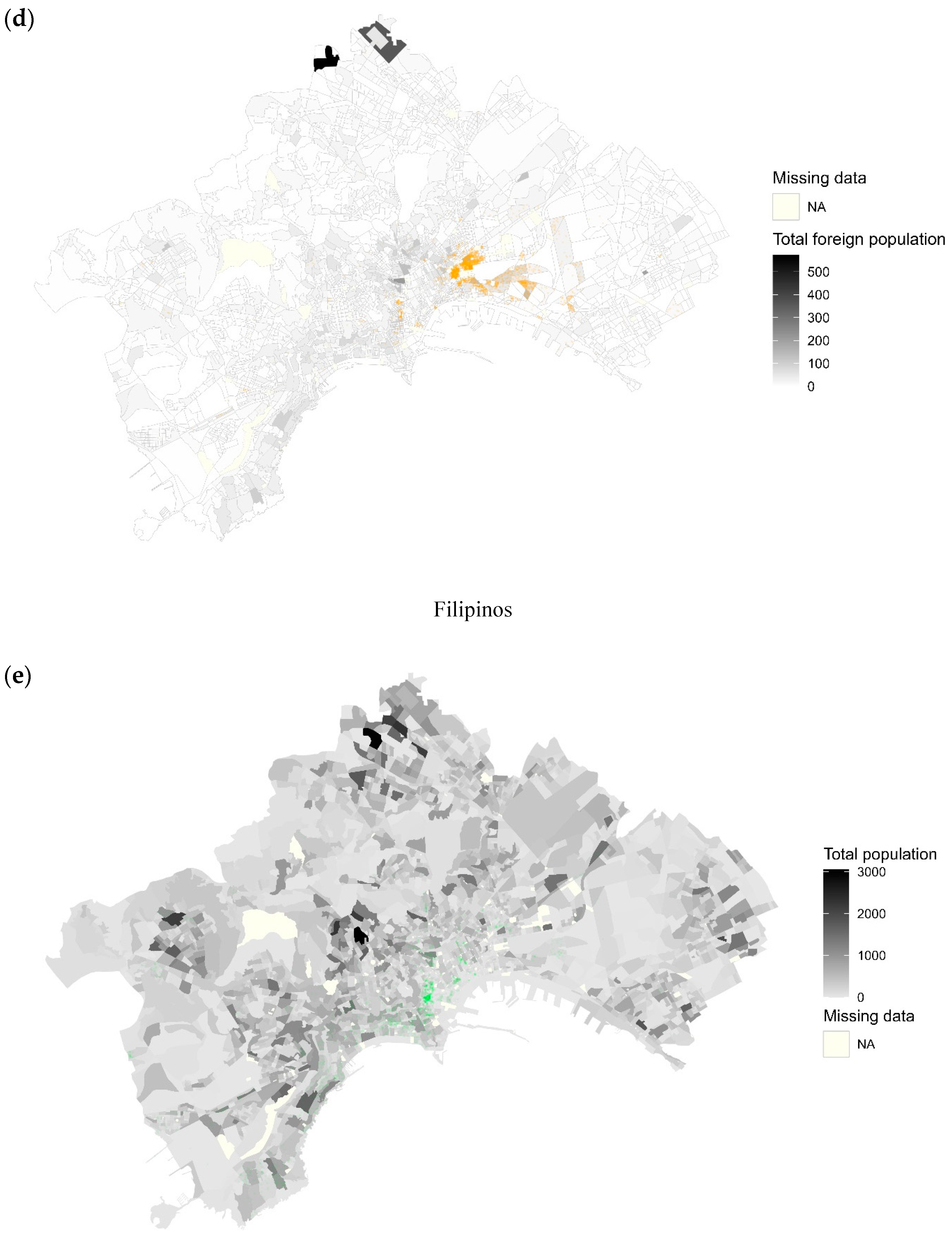
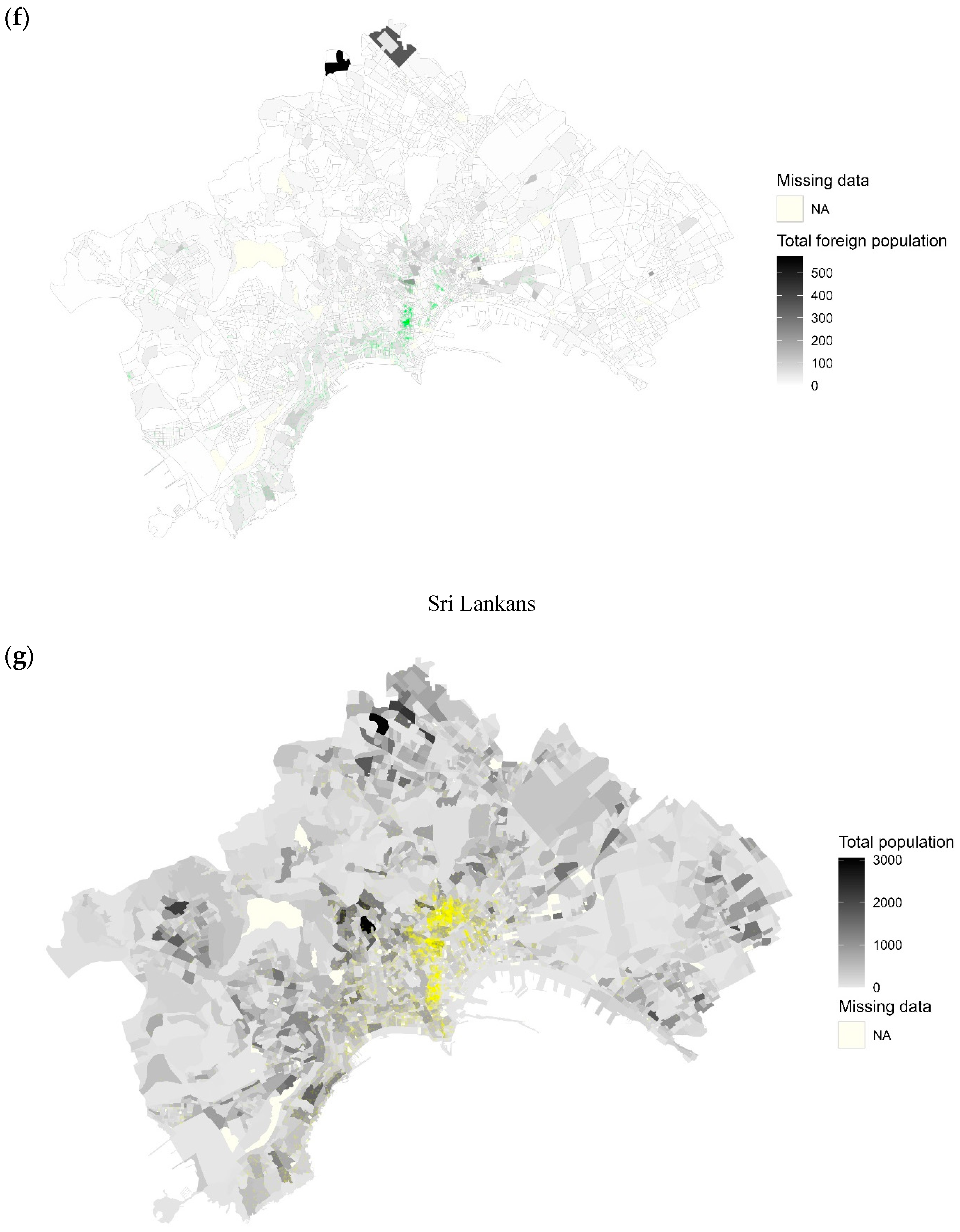
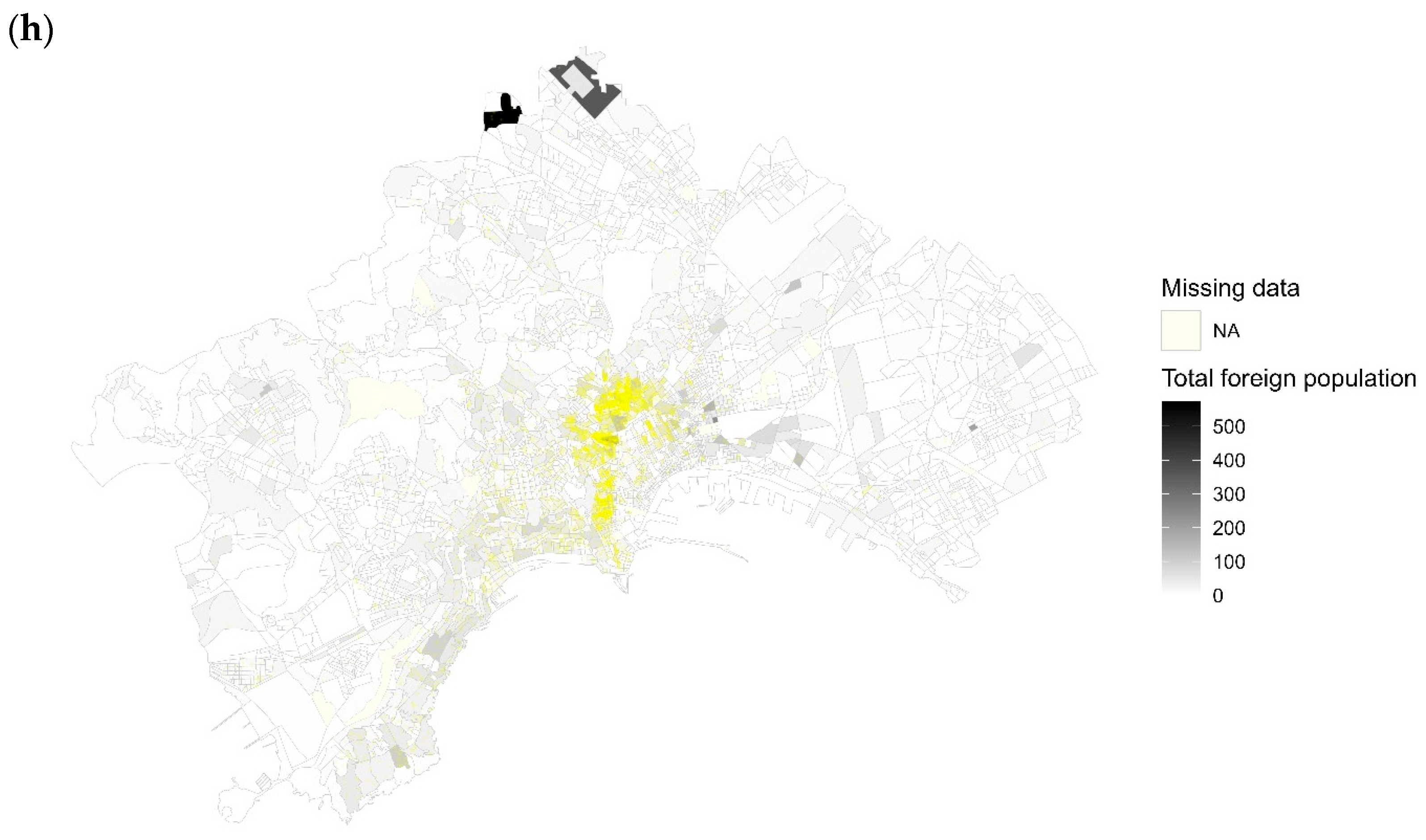
Residential segregation has been extensively studied in the literature, starting with the influential work of the Chicago School (Bailey 2012). The seminal studies by Duncan and Duncan (1955) and Massey and Denton (1988) focussed on measuring segregation as the level of spatial separation between two or more population groups within a specific context (Yao et al. 2019). Initially, the groups investigated were typically White and Black populations (Farley 1977) or the majority (indigenous population) versus a minority group (foreigners) (Kauppinen and van Ham 2019; Wessel et al. 2018). However, the increasing ethnic diversity in Western societies necessitates moving beyond this dichotomous analysis of segregation. As mentioned earlier, such an approach is unable to adequately explain the complex patterns of segregation in today’s multiracial, multi-ethnic societies (Kramer and Kramer 2019; Logan and Zhang 2010; Zwiers et al. 2017). In fact, the concept of segregation can be redefined as the extent to which individuals from different groups occupy and experience distinct social environments (Reardon and O’Sullivan 2004). For these reason, we exploited, together with standard between-group residential segregation indices, some multi-group indices. These indices were computed using the OasisR package (Tivadar 2019).
The traditional two-group indices that we considered were the Duncan’s dissimilarity index (D), the Delta index, the Bell’s isolation index (B), and the Shannon–Wiener (SW) diversity index. The dissimilarity index (DI) quantifies the level of segregation or dispersion of a minority group compared to the majority group, ranging from 0 (indicating no segregation or similar geographical distribution as the majority group) to 1 (representing complete separation).
The dissimilarity index (D) reveals how evenly people of different ethnic groups are distributed across areal units, in our case, across the 100 × 100 m squared cells obtained after the areal interpolation procedure (Duncan and Duncan 1955). One formula for the D is:
D = 0.5 i = 1 N | x i X y i Y |
where i is used to identify each of the N squared cells, while x and y are the foreign group and Italians, respectively. The D measures the disparity in the distribution of the specific foreign group compared to Italians, focusing on their evenness across spatial units. As a general guideline, a D below 0.30 suggests low segregation, while a range of 0.30 to 0.60 indicates moderate segregation, and values exceeding 0.60 indicate high segregation. It is important to note that these thresholds may vary depending on the national and local contexts (Massey and Denton 1993). The Delta index is a specialised version of the D (Duncan et al. 1961). It focusses on measuring the dissimilarity between the spatial distribution of a particular group and the distribution of available land. It can be seen as the proportion of the group that would need to relocate in order to achieve an even density across all spatial units.
B (Bell 1954) is an exposure index that measures the probability that two members of a group share the same spatial unit (Apparicio 2000). This indicator represents the average proportion of people from the same group living in a given neighbourhood. This refers to the exclusive presence of the same group in a neighbourhood—one of the main aspects of segregation. For an immigrant community x, B is defined as:
B = i = 1 N ( x i / X ) ( x i / P i )
where x i is the population of community x in neighbourhood i, X is the total population of community x at the urban level, and P i is the total population of neighbourhood i. Thus, an index of 1 would indicate that all members of community x live in a neighbourhood where 100% of the population belong to the same community (complete isolation). A B score close to 0 indicates that the proportion of community x is the same across all neighbourhoods in a urban area.
The SW diversity index (Shannon 1948) is based on the notion of entropy and measures population heterogeneity (Jost 2010). SW is calculated using the following formula:
S W = i = 1 N ( π i · l n ( π i ) )
where π i denotes the proportion or relative abundance of the i-th group considered. SW varies from 0—indicating the lowest level of evenness and the presence of a dominant population group (low level of mixing) to 1—the highest level of evenness with a uniform presence of different population groups (high level of mixing).
Here, we also considered two multi-group measures, namely, the multi-group version of Duncan’s (D) dissimilarity index (Morgan 1975; Sakoda 1981) and the multi-group version of Theil’s (H) index (Theil 1972; Theil and Finizza 1971), which has also been computed in its between-group version. In what follows, we provide their mathematical formulation following the notation adopted in Reardon and Firebaugh (2002). Specifying that x denotes the size of the specific group and π denotes proportion; subscript j indices territorial units (i.e., the squared cells); and subscript i indexes groups; hence, x j represents the group size in territorial unit j; X is the total size of the group; π i is the proportion of group i; π i j is the proportion of group i, of those in unit j, we provide the formula of the multi-group version of the Duncan’s dissimilarity index (MD) as:
M D = i = 1 N j = 1 M x j 2 I X | π i j π i |
where I represents the Simpson’s interaction index (Lieberson 1969; White 1986) defined as:
I = i = 1 N π i ( 1 π i ) .
The multi-group version (H) of the Theil’s entropy index measures the departure from evenness by assessing each spatial unit deviation from the entropy in the area considered. This entropy index (also called information index) measures the (weighted) average deviation of each areal unit from the urban area’s “entropy” or racial and ethnic diversity, which is greatest when each group is equally represented in the metropolitan area. H also varies between 0 (when all geographical units have the same composition as the entire urban area) and 1 (when all geographical units contain one group only). Maintaining the same definitions provided for the MD formulation, H can be written as:
H = i = 1 N j = 1 M x j X E π i j l n π i j π i
where E denotes the Theil’s entropy index defined as follows:
E = i = 1 N π i l n ( 1 π i ) .

3. Results

The areal weighted interpolation of the population counts allowed us to anchor the census tract level data to a uniform grid and to calculate the different indices on these newly arranged counts. The first general consideration, based on the values assumed by the indices (Table 2) across the three cities, was the presence of a north–south differential with Naples, and in a certain measure also to Rome, being more segregated than Milan with respect to all of the immigrant groups analysed. The standard and the multi-group versions of D, Delta, B, MD, and H took on values considerably higher in Naples, in accordance with the existing literature (Benassi et al. 2020a, 2020b). Despite the general difference in the level of segregation between cities, when drawing comparisons among the immigrant groups, a homogeneous situation emerged for all the urban areas considered. Specifically, the Bangladeshis and Chinese were the most segregated communities, while Filipinos and Sri Lankans appeared more dispersed over space, independently of the urban context. Moreover, both multi-group indices decreased when the Italians were included in the computation. This could suggest that that there is some degree of separation between the immigrant groups themselves, highlighting a difference in their allocation preference that goes beyond the status of immigrant.
Analysing the indices measuring the different dimensions of segregation between groups (Table 3), additional considerations conveyed a more articulated picture of the residential configuration across cities. In Milan, the most segregated group with respect to the other is that of Bangladeshis, while Sri Lankans, Chinese, and Filipinos appeared to share a more similar allocation pattern. This configuration disappeared in Rome and Naples, where each group exhibited high levels of segregation with respect to the other. The worst situation emerged in Naples. The different forms of segregation measured with respect to the Italians indicated that Filipinos showed low to moderate levels of segregation in Milan and Rome, while Sri Lankans exhibited medium segregation from Italians only in the city of Milan. Overall, the north–south gradient of segregation detected by previous research on Italian contexts was confirmed (see Section 1).
These results could be partially related to the fact that in general, excluding instances where ethnic discriminatory rules are enforced by law or traditions in certain places and times, we can identify two main factors shaping the spatial allocation of minority groups, as proposed by Schelling (1971). One factor is the presence of spatial inhomogeneity or “apparent contagion”. Typically, various areas within a city display significant disparities in residential property prices, accessibility to affordable public infrastructure, and the availability of specific job opportunities (Mazza and Punzo 2016). Therefore, even in the absence of ethnic discrimination, different ethnic groups would not be randomly distributed among residences. The second factor is spatial attraction or “true contagion”. Survey data from Clark and Fossett (2008) regarding the preferred neighbourhood composition for various ethnic groups in the USA indicate that all groups generally prefer to live in areas where their own group is a majority or close to it. These preferences stem from complex factors and may reflect a sense of attachment to group identity and culture such as language, religion, and customs. Newly arrived minority migrants may benefit from positive effects by settling in proximity to fellow compatriots such as experiencing mutual acceptance, sharing a common language, and receiving support. Additionally, transnational social networks play a significant role in guiding incoming migrants towards specific neighbourhoods and occupations, as highlighted by Gelderblom and Adams (2006).
The high segregation levels detected for Bangladeshis could be partly explained by the significant role played by chain migration. The existence of established Bangladeshi communities in certain areas acts as a pull factor for subsequent migrants, leading to the formation of ethnic enclaves and reinforcing segregation (Knights 1996).
Similarly, according to Chang (2012, p. 181), Chinese migration in Italy is described as a deliberate decision made in the family’s best interests. It is characterised by phenomena such as chain migration, ethnic enclaves, and a sense of familial duty. Additionally, the Chinese community in Italy tends to live in a relatively isolated manner, as noted, for example, by Mazza and Punzo (2016), and faces significant linguistic difficulties.
The Sri Lankans’ and Filipinos’ relatively lower levels of segregation align with the fact that they are mostly employed in the occupational niches of domestic assistance, housekeeping, waiting, factory-work in light industry, and cleaning services (Benassi et al. 2023b; Henayaka-Lochbihler and Lambusta 2004; Mazza et al. 2018). Since many of them work in Italian households, their allocation model is more adjusted to that of Italians, making proximity to workplace a strong factor influencing the residential choices.

4. Discussion and Conclusions

The study aimed to provide a snapshot of the ethnic residential segregation of four selected Asian foreign groups in 2011 in three Italian cities, namely, Milan, Rome, and Naples, representing the north, centre, and south of the country, respectively. The analysis focused on the segregation patterns of various ethnic groups and aimed to move beyond traditional binary notions of segregation to account for the complexities of a diverse and multicultural society. Moreover, the quantitative analysis was based on regular lattice data that allow for robust spatial comparison between different geographical settings.
The findings revealed a north–south differential in segregation levels, with Naples exhibiting the highest levels of segregation, followed by Rome, while Milan displayed relatively lower levels. The immigrant groups analysed including Bangladeshis, Chinese, Filipinos, and Sri Lankans showed varying degrees of spatial dispersion or concentration across the cities. The Bangladeshi and Chinese communities appeared more segregated, while the Filipinos and Sri Lankans were relatively more dispersed. The study also explored multi-group segregation measures, considering the interactions and allocation preferences among different ethnic groups. The inclusion of Italians in the analysis highlighted some degree of separation between the immigrant groups themselves, indicating differences in their residential preferences beyond their immigrant status. Comparisons among the cities and ethnic groups provided a nuanced understanding of the residential configuration. Milan showed higher segregation levels for Bangladeshis compared to the other groups, while Rome and Naples exhibited high levels of segregation for all of the analysed groups. Naples emerged as the city with the highest levels of segregation across various dimensions.
The study’s findings confirm the presence of a north–south segregation gradient in Italy, with the southern cities experiencing greater levels of segregation. Indeed, segregation seems to increase in those areas, the southern ones, which already face issues relating to economic deprivation, poverty, and marginalisation. As already pointed out in Benassi et al. (2023a), segregation is higher in the urban areas of Europe with a less stable economy and a high level of social vulnerability. As far as the current application is concerned, one can postulate that the north–south differential in the amount and diversification of productive and economic activities and their consequent urban spatial allocation could have influenced the residential choice of the foreign groups across the cities. Roughly speaking, the availability of many and more spatially dispersed economic and work opportunities, especially in Milan, could explain the lower levels of segregation. On the other hand, the less dynamic economy in Naples could foster the localisation of immigrants in proximity of the few productive activities available. Our findings and reasoning confirm what Ambrosini (2013) has called “the four territorial models of immigrant integration on the Italian labour market”. According to this classification, the “small and medium enterprises (SMEs) model” characterises the industrial provinces of the centre–north (especially the north-eastern ones), where immigrants are typically factory workers, and more and more women find jobs in the domestic or care sectors. The “metropolitan economies model”, typical of Milan and to a lesser extent Rome, show that the immigrants’ occupations are more varied but are included in a range that goes from building and restaurants to cleaning and transportation. The “seasonal activities model” of the south, which serves as a gateway for many immigrants, provides mostly temporary or irregular jobs in the agricultural sector. Here, women’s employment in housekeeping is also significant. The “seasonal activities model” of the centre–north characterises those regions attracting significant flows of seasonal workers, employed in the summer by the tourism industry and in autumn by fruit harvesting. A notable example is the region of Trentino-Alto Adige (Süd Tirol), where the regular employment rates are relatively higher. A similar classification of the immigrants’ integration process in Italy by economic sectors and regional economic variations has been proposed by Allasino et al. (2004). As well as the integration index proposed by Cesareo and Blangiardo (2009) to measure the migrants’ integration levels in Italy at the NUTS-3 level, which indicates a different level of integration, and is based, among other dimensions, on the characteristics of the local economies. Indeed, the economic sub-domain of the index registered a very high value for Milan, a medium value for Rome, and a low one for Naples. In summary, different regions in Italy exhibit distinct patterns of migrant worker employment, with variations in the sectors and types of jobs available as well as differences in employment stability and regularity.
In addition to the dynamics of socio-economic and professional polarisation, of which segregation is a spatial expression, depending on the territorial and institutional context of reference, there are mechanisms that can contribute to exacerbating or mitigating the segregation of immigrants, one of which is housing welfare (Costarelli and Mugnano 2017). In Italy, the housing problem faced by immigrants sheds light on numerous challenges that the Italian housing system must confront (Mugnano 2017). For a considerable period, the Italian housing system has been primarily oriented towards the property market. This circumstance leaves low-income immigrants, particularly newcomers, in a vulnerable position due to their inadequate resources to enter the housing market as homeowners or afford private rental accommodation. Notably, the availability of public residential buildings in Italy is currently at a level slightly below 5%. Many immigrants reside in rental houses, and often, this sector of the real estate market is the most discriminatory (Baldini and Federici 2011; Caritas 2011). Moreover, they usually live in precarious conditions due to overcrowding and poor housing quality (Costarelli and Mugnano 2017). Although the analysis of the implications of the real estate market and housing discrimination on ethnic segregation goes beyond the scope of the work, it is noteworthy to consider these dynamics and their urban-specific peculiarities when comparing segregation among different cities.
The increasing complexity and diversity of Italian urban contexts call for a deeper understanding of segregation dynamics and the adoption of suitable approaches to address the challenges and opportunities arising from the coexistence of diverse groups within urban areas. By employing multi-group segregation measures and considering the complexities of contemporary societies, this study contributes to the existing literature on residential segregation in Southern Europe (Benassi et al. 2020b). The future availability of data concerning other time periods will allow us to uncover the implications of the growing diversity of these Italian cities on the segregation and social inclusion of migrants. The current sociological debate on ethnic diversity and segregation is dominated by two contrasting schools of thought (Sturgis et al. 2014). According to the so-called “conflict theory”, the interethnic mixing can induce a feeling of threat and anxiety between minority and majority groups (Blalock 1967). In particular, Putnam stated that ethnic diversity leads people to “hunker down” (i.e., to withdraw from collective life and distrust their neighbours), regardless of their racial or ethnic background (Putnam 2007). Conversely, the “contact theory” proposes that racial diversity has the potential to diminish stereotyping and prejudice as it fosters direct interactions between individuals belonging to different ethnic groups (Allport 1954; Hewstone and Brown 1986).
Overall, the findings shed light on the spatial patterns of different ethnic groups in Italian cities and provide insights into the social and spatial dynamics of urban areas. Understanding and addressing segregation are crucial for fostering inclusive and cohesive societies. Future research could further investigate the underlying factors driving segregation in specific urban contexts and explore policy interventions to promote social integration and reduce disparities.

Author Contributions

Conceptualization, F.B. (Francesca Bitonti), F.B. (Federico Benassi), A.M. and S.S.; methodology, F.B. (Francesca Bitonti) and F.B. (Federico Benassi); software, F.B. (Francesca Bitonti) and A.M.; validation, A.M. and S.S.; formal analysis, F.B. (Francesca Bitonti); investigation, F.B. (Francesca Bitonti), F.B. (Federico Benassi), A.M. and S.S.; resources, S.S.; data curation, F.B. (Francesca Bitonti); writing—original draft preparation, F.B. (Francesca Bitonti); writing—review and editing, F.B. (Francesca Bitonti), F.B. (Federico Benassi), A.M. and S.S.; visualization, F.B. (Francesca Bitonti); supervision, F.B. (Federico Benassi), A.M. and S.S.; project administration, S.S. All authors have read and agreed to the published version of the manuscript.

Funding

This research received no external funding.

Informed Consent Statement

Not applicable.

Data Availability Statement

The population data (Italians, foreigners, and individual citizenships) for each municipality is available on the Istat website. The population data for the year 2011, without distinguishing individual citizenships, for census sections, is available on the Istat website and can be freely downloaded. Their distribution based on individual citizenships is not available but has been obtained through a specific scientific agreement. Consequently, the data is not accessible and cannot be released. Finally, the geographical bases, municipal shape files, and census section shape files can be freely downloaded from the Istat website.

Conflicts of Interest

The authors declare no conflict of interest.

Appendix A

The following figures show the spatial point pattern of the selected foreign groups displayed above the total resident population per census tract and the foreign total resident population per census tract. Given the initial number of foreigners was not georeferenced but just referred to the census tract, the number of points corresponding to the foreigners residing in the given census tract was randomly generated so that the number of points falling in each census tract, corresponds to the numerosity of the specific group in the same census tract.
Figure A1. Spatial distribution of the selected immigrant groups (in coloured dots) in the city of Milan. The number of points, randomly generated per each census tract, corresponds to the numerosity of the specific group in the same census tract. In the background (in grey scale) are the total resident population per census tract and the foreign total resident population per census tract, alternatively. Time period: 2011. Source: Authors’ elaboration on the Italian census data.
Socsci 12 00480 g0a1aSocsci 12 00480 g0a1bSocsci 12 00480 g0a1cSocsci 12 00480 g0a1dSocsci 12 00480 g0a1e
Figure A2. Spatial distribution of the selected immigrant groups (in coloured dots) in the city of Rome. The number of points, randomly generated per each census tract, corresponds to the numerosity of the specific group in the same census tract. In the background (in grey scale) are the total resident population per census tract and the foreign total resident population per census tract, alternatively. Time period: 2011. Source: Authors’ elaboration on the Italian census data.
Socsci 12 00480 g0a2aSocsci 12 00480 g0a2bSocsci 12 00480 g0a2cSocsci 12 00480 g0a2dSocsci 12 00480 g0a2e
Figure A3. Spatial distribution of the selected immigrant groups (in coloured dots) in the city of Naples. The number of points, randomly generated per each census tract, corresponds to the numerosity of the specific group in the same census tract. In the background (in grey scale) are the total resident population per census tract and the foreign total resident population per census tract, alternatively. Time period: 2011. Source: Authors’ elaboration on the Italian census data.
Socsci 12 00480 g0a3aSocsci 12 00480 g0a3bSocsci 12 00480 g0a3cSocsci 12 00480 g0a3dSocsci 12 00480 g0a3e

Notes

1
World Bank data were retrieved from: https://data.worldbank.org/topic/urban-development (accessed on 27 June 2023).
2
Data on the selected immigrant groups did not include individuals who acquired Italian citizenship.
3
The Data for Integration (D4I) dataset, recently released by the European Commission’s Knowledge Centre on Migration and Demography, provides valuable information on migration patterns. This dataset was created by spatially disaggregating statistics from the 2011 Census, which were collected by national statistical institutes. Through this spatial processing, the original data were transformed into a uniform grid, revealing the distribution of migrants in cells measuring 100 by 100 m. This comprehensive dataset covers cities in eight European countries, namely, France, Germany, Ireland, Italy, the Netherlands, Portugal, Spain, and the United Kingdom.

References

  1. Allasino, Enrico, Alessandra Venturini, and Giovanna Zincone. 2004. Labour Market Discrimination against Migrant Workers in Italy. Geneva: International Labour Organization. [Google Scholar]
  2. Allen, Judith, James Barlow, Jesus Leal, Thomas Maloutas, and Liliana Padovani. 2004. Housing and Welfare in Southern Europe. Oxford: Blackwell. [Google Scholar]
  3. Allport, Gordon. 1954. The Nature of Prejudice. Cambridge: Addison-Wesley. [Google Scholar]
  4. Ambrosini, Maurizio. 2013. Immigration in Italy: Between economic acceptance and political rejection. Journal of International Migration and Integration 14: 175–94. [Google Scholar] [CrossRef]
  5. Apparicio, Philippe. 2000. Les indices de ségrégation résidentielle: Un outil intégré dans un système d’information géographique. Cybergeo: European Journal of Geography 134. [Google Scholar] [CrossRef]
  6. Arapoglou, Vassilis P. 2012. Diversity, inequality and urban change. European Urban and Regional Studies 19: 223–37. [Google Scholar] [CrossRef]
  7. Arbaci, Sonia. 2004. Southern European multiethnic cities and the enduring housing crisis: Framing the urban and residential insertion of immigrants. Paper presented at ENHR Conference, Cambridge, UK, July 3. [Google Scholar]
  8. Arbaci, Sonia. 2007. The Residential Insertion of Immigrants in Europe: Patterns and Mechanisms in Southern European Cities. Ph.D. thesis, The Bartlett School of Planning—University College London, London, UK. [Google Scholar]
  9. Arbaci, Sonia. 2008. (Re)Viewing ethnic residential segregation in Southern European cities: Housing and urban regimes as mechanism 477 of marginalisation. Housing Studies 23: 589–613. [Google Scholar] [CrossRef]
  10. Bailey, Nick. 2012. How spatial segregation changes over time: Sorting out the sorting processes. Environment and Planning A: Economy and Space 44: 705–22. [Google Scholar] [CrossRef]
  11. Baldini, Massimo, and Marta Federici. 2011. Ethnic discrimination in the Italian rental housing market. Journal of Housing Economics 20: 1–14. [Google Scholar] [CrossRef]
  12. Bell, Wendell. 1954. A probability model for the measurement of ecological segregation. Social Forces 32: 357–64. [Google Scholar] [CrossRef]
  13. Benassi, Federico, Alessia Naccarato, Ricardo Iglesias-Pascual, Luca Salvati, and Salvatore Strozza. 2023a. Measuring residential segregation in multi-ethnic and unequal European cities. International Migration 61: 341–61. [Google Scholar] [CrossRef]
  14. Benassi, Federico, and Ricardo Iglesias-Pascual. 2022. Local-scale residential concentration and income inequalities of the main foreign-born population groups in the Spanish urban space. Reaffirming the model of a divided city. Journal of Ethnic and Migration Studies 49: 673–96. [Google Scholar] [CrossRef]
  15. Benassi, Federico, Corrado Bonifazi, Frank Heins, Fabio Lipizzi, and Salvatore Strozza. 2020a. Comparing Residential Segregation of Migrant Populations in Selected European Urban and Metropolitan Areas. Spatial Demography 8: 269–90. [Google Scholar] [CrossRef]
  16. Benassi, Federico, Fabio Lipizzi, and Salvatore Strozza. 2019. Detecting Foreigners’ Spatial Residential Patterns in Urban Contexts: Two Tales from Italy. Applied Spatial Analysis and Policy 12: 301–19. [Google Scholar] [CrossRef]
  17. Benassi, Federico, Francesca Bitonti, Angelo Mazza, and Salvatore Strozza. 2023b. Sri Lankans’ residential segregation and spatial inequalities in Southern Italy: An empirical analysis using fine-scale data on regular lattice geographies. Quality & Quantity 57: 1629–48. [Google Scholar] [CrossRef]
  18. Benassi, Federico, Ricardo Iglesias-Pascual, and Luca Salvati. 2020b. Residential segregation and social diversification: Exploring spatial settlement patterns of foreign population in Southern European cities. Habitat International 101: 102200. [Google Scholar] [CrossRef]
  19. Bitonti, Francesca, Aangelo Mazza, Massimo Mucciardi, and Luigi Scrofani. 2023. Urban transformations and the spatial distribution of foreign immigrants in Messina. In Models for Data Analysis: Paper presented at SIS Conference 2018, Palermo, Italy, June 20–22. Edited by Eugenio Brentari, Marcello Chiodi and Ernst-Jan Camiel Wit. Cham: Springer International Publishing, pp. 53–67. [Google Scholar]
  20. Blalock, Hubert M. 1967. Toward a Theory of Minority-Group Relations. New York: Wiley and Sons. [Google Scholar]
  21. Busetta, Annalisa, Angelo Mazza, and Manuela Stranges. 2015. Residential segregation of foreigners: An analysis of the Italian city of Palermo. Genus 491: 177–98. Available online: https://www.jstor.org/stable/genus.71.2-3.177 (accessed on 26 June 2023).
  22. Carella, Maria, and Roberta Pace. 2001. Some migration dynamics specifics to southern Europe: South-North and East-West Axis. International Migration 39: 63–99. [Google Scholar] [CrossRef]
  23. Caritas, Fondazione Zancan. 2011. Poveri di Diritti. Rapporto 2011 su Povertà ed Esclusione Sociale in Italia. Bologna: Il Mulino. [Google Scholar]
  24. Cesareo, Vincenzo, and Gian Carlo Blangiardo. 2009. Integration Indexes: Quaderni Ismu 2/2011. Milan: ISMU. [Google Scholar]
  25. Chang, Angela. 2012. 20th century Chinese migration to Italy: The Chinese diaspora presence within European international migration. History Compass 10: 179–90. [Google Scholar] [CrossRef]
  26. Clark, William A.V., and Mark Fossett. 2008. Understanding the social context of the Schelling segregation model. Proceedings of the National Academy of Sciences 105: 4109–14. [Google Scholar] [CrossRef] [PubMed]
  27. Costarelli, Igor, and Silvia Mugnano. 2017. Un’analisi della condizione abitativa degli stranieri a Roma e Milano: Micro-segregazione e periferizzazione. Fuori Luogo Rivista di Sociologia del Territorio Turismo Tecnologia 2: 39–47. [Google Scholar]
  28. Duncan, Otis Dudley, and Beverly Duncan. 1955. A methodological analysis of segregation indexes. American Sociological Review 20: 210–17. [Google Scholar] [CrossRef]
  29. Duncan, Otis Dudley, Ray P. Cuzzort, and Beverly Duncan. 1961. Statistical Geography: Problems in Analyzing Areal Data. Illinois: The Free Press of Glencoe. [Google Scholar]
  30. Farley, Reynolds. 1977. Residential segregation in urbanized areas of the United States in 1970: An analysis of social class and racial differences. Demography 14: 497–518. [Google Scholar] [CrossRef] [PubMed]
  31. Gelderblom, Derik, and Whynie Adams. 2006. The limits and possibilities of migrant networks. In Migration in South and Southern Africa: Dynamics and Determinants. Edited by John Oucho, Pieter Kok, Derik Gelderblom and Johan Van Zyl. Cape Town: HSRC Press, pp. 227–48. [Google Scholar]
  32. Goodchild, Michael F., Luc Anselin, and Uwe Deichmann. 1993. A Framework for the Areal Interpolation of Socioeconomic Data. Environment Planning A 25: 383–97. [Google Scholar] [CrossRef]
  33. Henayaka-Lochbihler, Ranjith, and Miriam Lambusta. 2004. The Sri Lankan Diaspora in Italy. Berlin and Heidelberg: Berghof Research Center for Conflict Management. [Google Scholar]
  34. Hewstone, Miles, and Rupert Brown. 1986. Contact Is Not Enough: An Intergroup Perspective on the ‘Contact Hypothesis’. In Contact and Conflict in Intergroup Encounters. Edited by Miles Hewstone and Rupert Brown. Oxford: Blackwell, pp. 1–44. [Google Scholar]
  35. Jost, Lou. 2010. The relation between evenness and diversity. Diversity 2: 207–32. [Google Scholar]
  36. Kauppinen, Timo M., and Maarten van Ham. 2019. Unravelling the demographic dynamics of ethnic residential segregation. Population Space and Place 25: e2193. [Google Scholar] [CrossRef] [PubMed]
  37. King, Russell. 2002. Toward a new map of European migration. International Journal of Population Geography 8: 89–106. [Google Scholar]
  38. King, Russell, ed. 1993. Mass Migration in Europe: The Legacy and the Future. London: Belhaven. [Google Scholar]
  39. Knights, Melanie. 1996. Bangladeshi Immigrants in Italy: From Geopolitics to Micropolitics. Transactions of the Institute of British Geographers 21: 105–23. [Google Scholar] [CrossRef]
  40. Kramer, Rory, and Peter Kramer. 2019. Diversifying but not integrating: Entropic measures of local segregation. Tijdschrift voor Economische en Sociale Geografie 110: 251–70. [Google Scholar] [CrossRef]
  41. Lieberson, Stanley. 1969. Measuring population diversity. American Sociological Review 34: 850–62. [Google Scholar] [CrossRef]
  42. Livi Bacci, Massimo. 2007. I grandi cicli migratori europei. Limes 4: 75–85. [Google Scholar]
  43. Logan, John R., and Charles Zhang. 2010. Global neighborhoods: New pathways to diversity and separation. American Journal of Sociology 115: 1069–109. [Google Scholar] [CrossRef]
  44. Malheiros, Jorge. 2002. Ethni-cities: Residential patterns in the Northern European and Mediterranean Metropolises- Implication for Policy Design. International Journal of Population Geography 8: 107–34. [Google Scholar] [CrossRef]
  45. Marcińczak, Szymon, Veronica Mooses, Magnus Strömgren, and Tiit Tammaru. 2021. A Comparative Study of Immigrant-Native Segregation at Multiple Spatial Scales in Urban Europe. Journal of Ethnic and Migration Studies 49: 43–65. [Google Scholar] [CrossRef]
  46. Massey, Douglas S., and Nancy A. Denton. 1988. The dimensions of residential segregation. Social Forces 67: 281–315. [Google Scholar] [CrossRef]
  47. Massey, Douglas S., and Nancy A. Denton. 1993. American Apartheid: Segregation and the Making of the Underclass. Cambridge: Harvard University Press. [Google Scholar]
  48. Mazza, Angelo, and Antonio Punzo. 2016. Spatial attraction in migrants’ settlement patterns in the city of Catania. Demographic Research 35: 117–38. [Google Scholar] [CrossRef]
  49. Mazza, Angelo, Giuseppe Gabrielli, and Salvatore Strozza. 2018. Residential segregation of foreign immigrants in Naples. Spatial Demography 6: 71–87. [Google Scholar] [CrossRef]
  50. Morgan, Barrie S. 1975. The segregation of socioeconomic groups in urban areas: A comparative analysis. Urban Studies 12: 47–60. [Google Scholar] [CrossRef]
  51. Mugnano, Silvia. 2017. Non Solo Housing. Qualità dell’Abitare in Italia nel Nuovo Millennio. Milan: FrancoAngeli. [Google Scholar]
  52. Musterd, Sako. 2005. Social and ethnic segregation in Europe: Levels, causes and effects. Journal of Urban Affairs 27: 331–48. [Google Scholar] [CrossRef]
  53. Musterd, Sako, and Arkaitz Fullaondo. 2008. Ethnic segregation and the housing market in two cities in northern and southern Europe: The cases of Amsterdam and Barcelona. ACE Arquitectura Ciudad y Entorno 3: 93–113. [Google Scholar] [CrossRef]
  54. Musterd, Sako, Szymon Marcińczak, Maarten van Ham, and Tiit Tammaru. 2015. Socio-Economic Segregation in European Capital Cities: Increasing Separation between Poor and Rich. Urban Geography 38: 1062–83. [Google Scholar] [CrossRef]
  55. OECD. 2018. Divided cities. In Understanding Intra-Urban Inequalities. Paris: OECD Publishing. [Google Scholar]
  56. Olteanu, Madalina, Cecile de Bezenac, William Clark, and Julien Randon-Furling. 2020. Revealing Multiscale Segregation Effects from Fine-Scale Data: A Case Study of Two Communities in Paris. Spatial Demography 8: 255–67. [Google Scholar] [CrossRef]
  57. Olteanu, Madalina, Julien Randon-Furling, and William A. Clark. 2019. Segregation through the multiscalar lens. Proceedings of the National Academy of Sciences 116: 12250–54. [Google Scholar] [CrossRef] [PubMed]
  58. Openshaw, Stan. 1984. Ecological Fallacies and the Analysis of Areal Census Data. Environment and Planning A 16: 17–31. [Google Scholar] [CrossRef] [PubMed]
  59. Openshaw, Stan, and Peter J. Taylor. 1979. A Million or so Correlation Coefficients: Three Experiments on the Modifiable Areal Unit Problem. In Statistical Applications in Spatial Sciences. Edited by Neil Wrigley. London: Pion, pp. 127–44. [Google Scholar]
  60. Panori, Anastasia, Yannis Psycharis, and Dimitris Ballas. 2019. Spatial segregation and migration in the city of Athens: Investigating the evolution of urban 481 socio-spatial immigrant structures. Population Space and Place 25: e2209. [Google Scholar] [CrossRef]
  61. Petsimeris, Petros, and Stefania Rimoldi. 2015. Socioeconomic divisions of space in Milan in the post-Fordist era. In Socioeconomic Segregation in European Capital Cities. East Meets West. Edited by Tiit Tammaru, Maarten van Ham, Szymon Marcińczak and Sako Musterd Abingdon. Oxon: Routledge, pp. 186–213. [Google Scholar]
  62. Piekut, Aneta, Gwilym Pryce, and Wouter van Gent. 2019. Segregation in the twenty first century: Processes, complexities and future directions. Tijdschrift Voor Economische En Sociale Geografie 110: 225–34. [Google Scholar] [CrossRef]
  63. Portes, Alejandro. 2000. Immigration and the metropolis: Reflections on urban history. Journal of International Migration and Integration 1: 153–75. [Google Scholar] [CrossRef]
  64. Prener, Christopher, and Charles Revord. 2019. Areal: An R Package for Areal Weighted Interpolation. Journal of Open Source Software 4: 1221. [Google Scholar] [CrossRef]
  65. Pugliese, Enrico. 2006. L’Italia Tra Migrazioni Internazionali e Migrazioni Interne. Bologna: Il Mulino. [Google Scholar]
  66. Putnam, Robert D. 2007. E Pluribus Unum: Diversity and Community in the Twenty-First Century: The 2006 Johan Skytte Prize Lecture. Scandinavian Political Studies 30: 137–74. [Google Scholar] [CrossRef]
  67. R Core Team. 2023. R: A Language and Environment for Statistical Computing. Vienna: R Foundation for Statistical Computing. Available online: https://www.R-project.org/ (accessed on 25 June 2023).
  68. Reardon, Sean F., and David O’Sullivan. 2004. Measures of spatial segregation. Sociological Methodology 34: 121–62. [Google Scholar] [CrossRef]
  69. Reardon, Sean F., and Glenn Firebaugh. 2002. Measures of multigroup segregation. Sociological Methodology 32: 33–67. [Google Scholar] [CrossRef]
  70. Rimoldi, Stefania M. L., and Laura Terzera. 2017. Neighbours and Friends? Can Residential Segregation Explain Ethnic Separation? The Case of Milan (Italy). Spatial Demography 5: 193–214. [Google Scholar] [CrossRef]
  71. Sakoda, James N. 1981. A generalized index of dissimilarity. Demography 18: 245–50. [Google Scholar] [CrossRef] [PubMed]
  72. Schelling, Thomas C. 1971. Dynamic models of segregation. Journal of Mathematical Sociology 1: 143–86. [Google Scholar] [CrossRef]
  73. Shannon, Claude Elwood. 1948. A mathematical theory of communication. The Bell System Technical Journal 27: 379–423. [Google Scholar] [CrossRef]
  74. Strozza, Salvatore. 2010. International migration in Europe in the first decade of the 21st century. Rivista Italiana di Economia Demografia e Statistica 64: 7–43. [Google Scholar]
  75. Strozza, Salvatore, Federico Benassi, Raffaele Ferrara, and Gerardo Gallo. 2016. Recent demographic trends in the major Italian urban agglomerations: The role of foreigners. Spatial Demography 4: 39–70. [Google Scholar] [CrossRef]
  76. Sturgis, Patrick, Ian Brunton-Smith, Jouni Kuha, and Jonathan Jackson. 2014. Ethnic diversity, segregation and the social cohesion of neighbourhoods in London. Ethnic and Racial Studies 37: 1286–309. [Google Scholar] [CrossRef]
  77. Tammaru, Tiit, Szymon Marcińczak, Maarten van Ham, and Sako Musterd. 2016. Socioeconomic Segregation in European Capital Cities: East Meets West (Regions and Cities). London: Routledge. [Google Scholar]
  78. Tammaru, Tiit, Szymon Marcińczak, Raivo Aunap, and Maarten van Ham. 2017. Inequalities and Segregation across the Long-Term Economic Cycle: An Analysis of South and North European Cities. Bonn: Institute of Labor Economics (IZA), p. 10980. [Google Scholar]
  79. Theil, Henri. 1972. Statistical Decomposition Analysis. Amsterdam: North-Holland. [Google Scholar]
  80. Theil, Henri, and Anthony J. Finizza. 1971. A Note on the measurement of racial integration of schools by means of informational concepts. Journal of Mathematical Sociology 1: 187–93. [Google Scholar] [CrossRef]
  81. Tivadar, Mihai. 2019. OasisR: An R package to bring some order to the world of segregation measurement. Journal of Statistical Software 89: 1–39. [Google Scholar] [CrossRef]
  82. van Ham, Maarten, Tiit Tammaru, Rūta Ubarevičienė, and Heleen Janssen. 2021. Urban Socio-Economic Segregation and Income Inequality: A Global Perspective. Berlin and Heidelberg: Springer. [Google Scholar]
  83. Van Kempen, Ronald, and A. Şule Özüekren. 1998. Ethnic segregation in cities: New forms and explanations in a dynamic world. Urban Studies 35: 1631–56. [Google Scholar] [CrossRef]
  84. Vertovec, Steven. 2007. Super-diversity and its implications. Ethnic and Racial Studies 30: 1024–54. [Google Scholar] [CrossRef]
  85. Wacquant, Loïc. 2007. Urban Outcasts: A Comparative Sociology of Advanced Marginality. Cambridge: Polity Press. [Google Scholar]
  86. Wessel, Terje, Lena Magnusson Turner, and Viggo Nordvik. 2018. Population dynamics and ethnic geographies in Oslo: The impact of migration and natural demographic change on ethnic composition and segregation. Journal of Housing and the Built Environment 33: 789–805. [Google Scholar] [CrossRef]
  87. Wessendorf, Susanne. 2014. ‘Being open, but sometimes closed’. Conviviality in a super-diverse London neighbourhood. European Journal of Cultural Studies 17: 392–405. [Google Scholar] [CrossRef]
  88. White, Michael J. 1986. Segregation and diversity measures in population distribution. Population Index 52: 198–221. [Google Scholar] [CrossRef] [PubMed]
  89. Yao, Jing, David W. Wong, Nick Bailey, and Jonathan Minton. 2019. Spatial segregation measures: A methodological review. Tijdschrift voor Economische en Sociale Geografie 110: 235–50. [Google Scholar] [CrossRef]
  90. Zwiers, Merle, Maarten van Ham, and David Manley. 2017. Trajectories of ethnic neighbourhood change: Spatial patterns of increasing ethnic diversity. Population, Space and Place 24: e2094. [Google Scholar] [CrossRef]
Table 1. Summary statistics of the selected immigrant groups (BGD = Bangladeshis, CHN = Chinese, PHL = Filipinos, LKA = Sri Lankans) in the cities of Milan, Rome, and Naples as recorded in the Italian General Population Censuses in 2001, 2011, and 2021.
Value/YearBGDCHNPHLLKATotal Immigrants
Milan
Absolute values
2001769555614,673488987,590
2011374019,79533,21411,440198,813
202110,32830,68837,54015,503253,531
% of immigrants in the city
20010.96.316.85.629.6
20111.910.016.75.734.3
20214.112.114.86.137.1
% of the nationality in Italy
20015.211.827.218.56.6
20114.59.924.615.54.9
20216.510.223.614.35.0
Rome
Absolute values
20013124290313,105229698,427
201117,84112,09628,4105228260,171
202132,96317,24438,4848719338,548
% of immigrants in the city
20013.22.913.32.321.8
20116.94.610.92.024.4
20219.75.111.42.628.8
% of the nationality in Italy
200121.36.224.38.77.4
201121.76.121.07.16.5
202120.75.724.28.16.7
Naples
Absolute values
20011428548014968757
201146126361587723835,580
202119604412170814,29153,440
% of immigrants in the city
20010.23.35.517.126.0
20111.37.44.520.333.5
20213.78.33.226.741.9
% of the nationality in Italy
20010.10.60.95.70.7
20110.61.31.29.80.9
20211.21.51.113.21.1
Table 2. Segregation indices for the selected immigrant groups (BGD = Bangladeshis, CHN = Chinese, PHL = Filipinos, LKA = Sri Lankans) in Milan, Rome, and Naples. Time period: 2011. Source: Authors’ elaboration.
Segregation IndicesMilan
BGDCHNPHLLKA
Duncan’s dissimilarity
(ref. group: Italians)
0.78970.60670.42140.4887
Multi-group Duncan’s
dissimilarity
0.4777
Multi-group Duncan’s
dissimilarity
(including Italians)
0.4566
Delta0.84230.67880.54350.5904
Bell’s isolation
(ref. group: Italians)
0.06120.09960.07570.0361
Theil’s entropy
(ref. group: Italians)
0.32840.24510.12910.1435
Multi-group Theil’s entropy0.2944
Multi-group Theil’s entropy
(including Italians)
0.176
Segregation IndicesRome
BGDCHNPHLLKA
Duncan’s dissimilarity
(ref. group: Italians)
0.71510.69890.51720.7308
Multi-group Duncan’s
dissimilarity
0.6521
Multi-group Duncan’s
dissimilarity
(including Italians)
0.5467
Delta0.86730.84930.71300.7912
Bell’s isolation
(ref. group: Italians)
0.22030.0740.04550.0302
Theil’s entropy
(ref. group: Italians)
0.38120.28950.16280.2598
Multi-group Theil’s entropy0.4955
Multi-group Theil’s entropy
(including Italians)
0.2559
Segregation IndicesNaples
BGDCHNPHLLKA
Duncan’s dissimilarity
(ref. group: Italians)
0.94440.90420.79720.6765
Multi-group Duncan’s
dissimilarity
0.7837
Multi-group Duncan’s
dissimilarity (including Italians)
0.7086
Delta0.96620.88140.76690.6958
Bell’s isolation
(ref. group: Italians)
0.04660.16050.02570.0525
Theil’s entropy
(ref. group: Italians)
0.45670.50870.28910.2523
Multi-group Theil’s entropy0.6636
Multi-group Theil’s entropy
(including Italians)
0.3287
Table 3. Segregation indices across the selected immigrant groups (BGD = Bangladeshis, CHN = Chinese, PHL = Filipinos, LKA = Sri Lankans) and Italians (ITA) in Milan, Rome, and Naples. Time period: 2011. Source: Authors’ elaboration.
Segregation IndicesLKA—BGDLKA—CHNLKA—PHLLKA—ITABGD—CHNBGD—PHLBGD—ITACHN—PHLCHN—ITAPHL—ITA
Milan
Duncan’s dissimilarity0.72440.6020.44390.4890.67460.69410.790.5390.6070.421
Theil’s entropy0.53530.4260.2310.1440.44920.41960.3280.33340.2450.129
Bell’s isolation0.88550.6630.43670.0360.51030.40330.0610.60660.10.076
Shannon–Wiener diversity0.55830.6570.5690.060.43790.32770.0240.66080.0930.138
Segregation IndicesRome
Duncan’s dissimilarity0.84310.8510.66030.7310.57960.74450.7150.7670.6990.517
Theil’s entropy0.90620.9310.70960.7630.56430.79870.770.8190.7320.459
Bell’s isolation0.74460.7740.46030.260.39010.60120.3810.61180.290.163
Shannon–Wiener diversity0.82170.8570.52410.030.77110.77560.220.74430.0740.046
Segregation IndicesNaples
Duncan’s dissimilarity0.92440.9310.65670.6770.76770.92440.9440.91360.9040.797
Theil’s entropy0.97050.9710.66730.6670.80480.97910.9670.96960.9420.828
Bell’s isolation0.81740.8640.43110.2520.58280.87720.4570.85640.5090.289
Shannon–Wiener diversity0.98720.9690.89420.0530.64110.91360.0470.9530.1610.026
Disclaimer/Publisher’s Note: The statements, opinions and data contained in all publications are solely those of the individual author(s) and contributor(s) and not of MDPI and/or the editor(s). MDPI and/or the editor(s) disclaim responsibility for any injury to people or property resulting from any ideas, methods, instructions or products referred to in the content.

