Article

Hot Spots of Gun Violence in the Era of Focused Deterrence: A Space-Time Analysis of Shootings in South Philadelphia

by
Jamie Anne Boschan
and
Caterina G. Roman
*
Department of Criminal Justice, Temple University, Philadelphia, PA 19122, USA
*
Author to whom correspondence should be addressed.
Soc. Sci. 2024, 13(2), 119; https://doi.org/10.3390/socsci13020119
Submission received: 29 December 2023 / Revised: 7 February 2024 / Accepted: 9 February 2024 / Published: 16 February 2024
(This article belongs to the Section Community and Urban Sociology)

Abstract

:
Gun and street group violence remains a serious problem in cities across the United States and the focused deterrence strategy has been a widely applied law enforcement intervention to reduce it. Although two meta-analytical studies concluded that the intervention had a significant effect on violence, questions remain about how violence changes across space and time during and after the intervention. This study applies novel geospatial analyses to assess spatiotemporal changes in gun violence before, during, and after the implementation of Philadelphia Focused Deterrence. Emerging hot spot analysis employing Space-Time cubes of ten annual time bins (2009–2018) at the Thiessen polygon level was used to detect and categorize patterns. The analyses revealed a non-significant decreasing trend across the ten-year period. Furthermore, there were ninety-three statistically significant hot spots categorized into four hot spot patterns: fourteen new hot spots; twenty-three consecutive; one persistent; and fifty-three sporadic. There was no evidence showing statistically significant hot spots for the “diminishing” pattern. Knowledge of these patterns that emerge across micro-locations can be used by law enforcement practitioners to complement data-driven problem solving and fine tune these strategies and other place-based programming. Policymakers can use findings to prioritize resources when developing complementary prevention and intervention efforts by tailoring those efforts to the different emergent patterns.

1. Introduction

Similar to many large urban areas, the city of Philadelphia, Pennsylvania, has experienced persistent gun violence over the last few decades, and group-based or gang violence is believed to be a significant contributor (Howell 2018; Lane 1989). In April 2013, the city implemented a focused deterrence strategy (Braga and Kennedy 2021; Kennedy 2011), as an intervention to reduce street group1-related gun violence. The Philadelphia Focused Deterrence strategy was modeled on Boston’s Operation Ceasefire program and consisted of bringing police-identified street group members into meetings where they were told to stop the shooting and simultaneously offered services and assistance. If shootings did not stop, however, the police would aggressively enforce a range of law enforcement levers across members of the group deemed responsible for the shooting. These levers could include, but were not limited to, outstanding warrant searches, arrests for illegal utilities or cable setups, and unpaid child support. The message, along with consistent and sustained enforcement of levers, should lead to noticeable and substantial increases in the perceived risk of apprehension among both past offenders and potential offenders. Hence, this potentially swifter and more certain-than-normal punishment should generate deterrent effects.
Today, the strategy is often referred to as the Group Violence Intervention (GVI) when it is targeted to street groups (as opposed to individuals or drug markets). The National Network for Safe Communities (NNSC), the organization guiding the strategy, reports that focused deterrence has been implemented in over 60 cities since 2009 (National Network for Safe Communities (NNSC) 2022). After two meta-analytical studies produced positive findings on focused deterrence models, including GVI, policymakers and scholars alike tend to label GVI as “evidence-based” with regard to its success in reducing aggregate levels of violence in the areas comprising the focal gangs (Braga and Weisburd 2012; Braga et al. 2018). For the most part, evaluations that came after the meta-analytic results were published also found GVI to be a success (Fox et al. 2022 [Tampa, Florida]; Braga et al. 2019 [Oakland, California]), although at least one recent study found no reductions in gun violence after the implementation of it (Leasure et al. 2023). An evaluation of Kansas City’s GVI intervention (Fox and Novak 2018) found that although the strategy, implemented with fidelity, was able to significantly reduce homicides and gun-involved aggravated assaults in the first year, the effect wore off after 12 months. Moreover, homicides returned to their pre-implementation levels in the second year and by the third year, gun-involved aggravated assaults increased to levels higher than the pre-implementation period.
In Philadelphia, the evaluation, published in 2019 (Roman et al. 2019), showed a statistically significant reduction in aggregate shootings across South Philadelphia in the 24-month period after the implementation of the intervention (2013–2015) compared to statistically matched neighborhoods, but there was inconsistent evidence of reductions in shootings committed by the specific street groups targeted. The evaluators assessed changes in group-level shootings in two ways: first, by comparing shootings in small geographically focused areas associated with the 14 targeted groups against matched comparison areas, and second, by assessing changes in shootings by the 14 groups (an identified member of a given group was identified as the perpetrator) anchored by the date each group first had members attend call-in notification meetings informing them about the strategy. Although most of the statistical estimates were in the hypothesized direction, they did not reach statistical significance. Moreover, descriptive analysis of the average change in gang-identified perpetrator shootings revealed that four of the fourteen targeted groups either increased their level of shootings after the implementation of the intervention or there was no change (see Figure 1 in Hyatt et al. 2021). The Philadelphia Focused Deterrence evaluators suggested that it should not be expected that all groups respond the expected way to the intervention (i.e., stopped shooting) because the extent of and duration of enforcement activities employed varied across street groups and members. Furthermore, street groups, even those situated within the same neighborhoods, can have very different characteristics and behaviors (Klein and Maxson 2006). The Philadelphia evaluators stressed the importance of evaluation studies to embed researchers within law enforcement agencies to extend the types of problem analyses that can inform ongoing strategizing throughout the implementation of an intervention and to help understand any unexpected findings. Without specifically studying the behavior of individuals touched by the intervention, one should not infer from studies showing aggregate reductions in violence after GVI that individual gang members and groups as a whole directly changed their behaviors in response to the intervention (Braga et al. 2019; Roman 2021).
For any policing strategy that targets micro-places, careful analysis of geo-referenced crime data with advanced techniques could help uncover patterns of violence over time that uniquely inform strategy and the delivery of social services or other resources to enduring hot spots of gun violence. Geographic analyses allow law enforcement to be more precise in targeting places and/or “people within places” where there have been long histories of violence. Violence is not only concentrated in places but also among offenders (Piquero et al. 2007). Furthermore, crime is a networked behavior, meaning that the conduct of criminal incidents is closely tied to the relationships between offenders and potential offenders (Thornberry et al. 2003). Cities that implement GVI usually undergo a problem-solving process and analyze homicide and gun crime data. This allows strategy leaders to focus on highly active groups where gun violence has been most recently concentrated. GVI “audits” of street groups and locations provide a means to assess group composition and membership so that group-wide consequences following a shooting can be utilized. In other words, law enforcement levers are used on all or most group members, regardless of involvement in the shooting that prompted an enforcement action. (Ideally, however, the model suggests that if threats become credible enough, they do not need to be carried out because over time, group members and potential offenders, and the community at large, would see laws being upheld in a legitimate and procedurally just manner.)
Researchers who have access to intelligence data on groups and group members have an advantage in the types of behavior change patterns they can examine when evaluating targeted violence reduction strategies. For instance, Braga and his colleagues, who have been studying outcomes related to GVI for over two decades, have had access to city-wide group level and individual group member data that allow for a nuanced assessment of changes in gun violence and recidivism by group and group member. Over the years, cities such as Boston, Massachusetts and Oakland, California have been able to assess spillover deterrent effects of GVI because they had knowledge of the street groups that were allied or fighting against each other. Examining potential spillover effects with Boston’s GVI strategy, Braga and colleagues (Braga et al. 2013) found that even if groups were not directly targeted by GVI, there were vicarious benefits in that deterrence was operating through the treatment of rivals and allies. Similarly, the authors of the Oakland, California evaluation of GVI (Braga et al. 2019) found spillover deterrent effects of varying magnitudes for vicariously treated groups. But it is also important to note that most evaluations of GVI have not examined potential spillover effects nor assessed possible displacement of violence. Hatten and Piza (2022, p. 129) remind us that this is typical of most evaluations of targeted crime reduction programs, and in general, there is a “dark figure of displacement”, where the true nature of the movement of crime after an intervention remains hidden or unknown. They also encourage more comprehensive and systematic reporting of results of evaluations because of the publication bias in policing interventions, where only studies with positive results tend to be published, creating an inflated perception of program effectiveness (Bowers et al. 2011).
Furthermore, theory suggests, and some studies have confirmed, that removing key players involved in violence from a neighborhood can create opportunities for new rivalries or spur street groups to expand their territories into new areas not heavily policed (Decker and Pyrooz 2015; Lawton et al. 2005). These types of spatial and network changes will not show up in statistical models that are only focused on the magnitude or frequency of violent incidents. Furthermore, recent research indicates that change within high crime clusters is remarkably rare within micro-places. Walter and colleagues (Walter et al. 2023b) assessed yearly changes in crime across street segments in six cities, including Philadelphia. Across the cities, change ranged from 1.1% of street segments in San Antonio to 6.8% of street segments in Philadelphia.
Given the lack of studies assessing potential spatial changes in gun violence after focused deterrence strategies have been implemented, coupled with the Philadelphia Focused Deterrence evaluation findings, indicating that a few of the groups did not appear to change their shooting-related behavior (Roman et al. 2019) and there were stark differences in social media usage and other characteristics across the targeted groups (Hyatt et al. 2021), the current study asks the following research questions: how do the hot spots of intentional shootings that existed in the years before the Philadelphia Focused Deterrence intervention in 2013 change after its implementation? More specifically, what were the patterns of change over time? For instance, did any hot spots significantly diminish? Were there any unexpected findings, such as new hot spots?
The target area for the intervention—South Philadelphia (see Figure 1)—was selected by city leaders because of the enduring nature of street groups in the area, the strong link between street groups and hot spots of gun violence, and long-standing and trusting relationships between investigators from the police department and the District Attorney’s Office who worked on South Philadelphia gun violence cases (more information on the strategy and its history can be found in (Roman et al. 2020). With the implementation of the targeted gun violence reduction strategy, we hypothesize that the hot spots of gun violence present before the intervention would become less hot over time or totally disappear. In addition, because the intervention was focused on all actively violent street groups in the area, we also expect that there would be little displacement of gun violence to other areas nearby (still within the large target area). A nuanced assessment of spatiotemporal changes may provide results that offer some insight into whether street groups (and/or individuals) changed their shooting behaviors and help stakeholders pinpoint areas for continued, strengthened, or novel interventions. Outside of Philadelphia stakeholders, practitioners, policymakers, and researchers may be interested in how techniques used in this study can be applied in their jurisdictions and future evaluations of targeted policing interventions.

2. Methods

Spatiotemporal analytical techniques, described further below, were used to answer the research questions as to how the hot spots of gun violence (i.e., intentional shootings) changed over time during and after the intervention was fully implemented. The area of study is the South Division of the Philadelphia Police Department (PPD), where the intervention was implemented (see Figure 1). The South Division, bounded by South Street to the North, the Delaware River to the east, and the Schuylkill River to the west, includes three Police Districts (PDs) generally known as South Philadelphia. The intervention was designed to reach all street groups in these PDs that were actively engaged in violence within the two years before the strategy began (~2011–2012).
Publicly available shooting victim data from Philadelphia for 2008 to 2021 was downloaded from OpenDataPhilly.org. The relevant fields within the dataset include the date, time, location, and x and y coordinates. Shootings are reported by the PPD at the victim level; hence, each record represents one shooting victim. The areal unit used for this study is Thiessen polygons (TPs), a geometric unit that contains all geographic space closest to its centroid (street corners) than any other polygon’s centroid (Chainey and Ratcliffe 2005; Taniguchi et al. 2011). This unit of measure suits our theoretical and practical purposes in that street corners and their contiguous blocks are central hubs of activity for street groups (Taniguchi et al. 2011; Topalli et al. 2002), and shootings by street groups tend to cluster around their territories (Gravel et al. 2023). The average size of a TP in South Philadelphia is roughly 0.02 square kilometers. Research also shows that violence clusters at very small units—or micro-places—and scholars recommend that corresponding violence reduction programming, including policing efforts, be targeted in small areas with the most violence to deliver limited resources directly to the areas most in need (Herrmann 2013; Taylor et al. 2011). The South Philadelphia target area comprises 2783 TPs. The x and y coordinates for the shootings were used to aggregate the shootings in TPs. Almost 97% of shooting victim data were successfully assigned a TP, an acceptable hit rate (Ratcliffe 2004).

Spatiotemporal Analyses

Some important considerations in choosing a technique for spatiotemporal analyses of hot spots include the purpose of hot spot analysis, sample size, scale of analysis, and available software. There is no universal definition of a hot spot. He et al. (2022) describe two meanings of the term “hot spot”: first, as places where crimes are concentrated, and second, as places where there may be a statistically significant concentration of crimes. In their view, the former lends itself to hot spot detection methods, such as hot spot mapping and clustering techniques, while the latter lends itself to statistical measures, such as the Spatial Scan Statistic, Local Moran’s I, and Getis-Ord Gi* statistics. In this study, we aim to measure how shooting concentrations changed over time, necessitating a method that goes beyond simple visual comparison. A second consideration here is the rare nature of gun violence (and crime in general) and its uneven spatial distribution. It is not uncommon to have many areas with zero counts next to areas with large crime numbers. The rare nature of gun violence is even more pronounced and potentially problematic for statistical analyses when using small geographic units.
We chose ArcGIS Pro and ran Getis-Ord Gi*-based (Getis and Ord 1992) optimized hot spot analysis first to establish the significant hot spots and then utilized Space-Time cubes to run emerging hot spot analysis. These techniques within ArcGIS Pro work with rare event data that include many zeros across spatial units and can visually display a range of potential changes in crime concentration over time. They were developed to increase visualization and interpretability when examining changes across time and space. A Space-Time cube is a 3D representation of a geographical area over time where the time slices or “bins” represent the vertical, or z, axis and have values (in our case, shooting victims). Statistical analyses can be performed on the Space-Time cubes. Optimized hot spot analysis and emerging hot spot analysis techniques are relatively new and are available through ArcGIS (An et al. 2015). The first step establishes spatial relationships, specified by the user. We used queen contiguity, where two TPs have contiguity if they share an edge or a boundary. Then, Getis-Ord Gi* statistics are calculated on each Space-Time cube, identifying statistically significant hot spots (and/or cold spots) as assessed by z-scores and p-values. To assess and evaluate temporal changes, emerging hot spot analysis relies on a Mann–Kendall statistic that compares temporal trends in each bin to the null hypothesis of no temporal change and then also combines the Getis-Ord Gi* and Mann–Kendall results together to designate patterns into ordinal categories. These novel techniques have been used in recent crime studies (Kortas et al. 2022; Nepomuceno and Costa 2019; Sweet et al. 2020; Vadlamani and Hashemi 2020) and in other fields (see, for example, Ashok et al. 2022; Fatima et al. 2021; Mamiit et al. 2021; Morckel and Durst 2021; Van Der Zee et al. 2020; Zerbe et al. 2022).
To answer the research questions, we first compare shooting victim hot spots in a three-year pre-implementation period to a later three-year period corresponding to the years in which Philadelphia Focused Deterrence was fully implemented (i.e., all street groups were touched by the intervention), including the period when it was starting to unravel. Although Philadelphia stakeholders were designing the intervention in 2012, the first call-in notification meeting did not take place until April 2013. Hence, this study uses 2009 to 2011 as the pre-implementation period compared to 2015 to 2017 as the post-implementation period. The hot spots were calculated based on the count of shooting victims for each TP. We utilize statistics capturing both similarity and association, as these measures are different; similarity captures how closely the spatial picture aligns across the periods. The similarity statistic is regarded as a fuzzy probability, indicating that any pair of corresponding features have the same significance level category. The associational measure is a spatial fuzzy Kappa statistic that captures the strength of the statistical relationship that underlies the comparison, somewhat like the use of a correlation coefficient. Fuzzy methods were developed to compare maps with many small features (Dou et al. 2007). The fuzzy Kappa measures the degree of agreement between two maps beyond what might be expected by chance. Spatial fuzzy Kappa values will generally range from 1 to 0, where a value of 1 signifies perfect agreement, and 0 indicates agreement equal to random chance. Typically, researchers use measures of association when comparing maps of substantively different features (e.g., crime rate and poverty); although this study is comparing the same features (shooting victims) across different time periods, we use measures of similarity and association to obtain a richer understanding of spatial changes in the clustering of shooting victims at the TP level.
Second, to examine and categorize the patterns of hot spots over time across a ten-year time span (2009 through 2018) that includes the two comparison periods, we utilized emerging hot spot analyses where the changes are categorized into one of eight possible hot or cold spot “patterns”. We chose this particular ten-year period because it comprises a solid number of years before the implementation of the intervention when law enforcement stressed the enduring nature of the South Philadelphia street groups and corresponding hot spots as reasons for selecting the focused deterrence strategy for operation there. The time span also includes full implementation years and a few years when the strategy was slowing down and unraveling. This period consisted of the dismantling of the South Philadelphia gang task force, no call-in notification meetings occurring, and the new Philadelphia District Attorney, who took office in January 2018, firing the head of the Gun Violence Task Force (the point person for the strategy) and everyone in the office closely associated with focused deterrence.
The patterns that can be detected through the emerging hot spots analysis are shown in Table 1. These analyses are descriptive and explorative; they are not intended to suggest causal mechanisms as a result of focused deterrence. All hot spot statistics were calculated in ArcGIS Pro (version 3.1.2).

3. Results

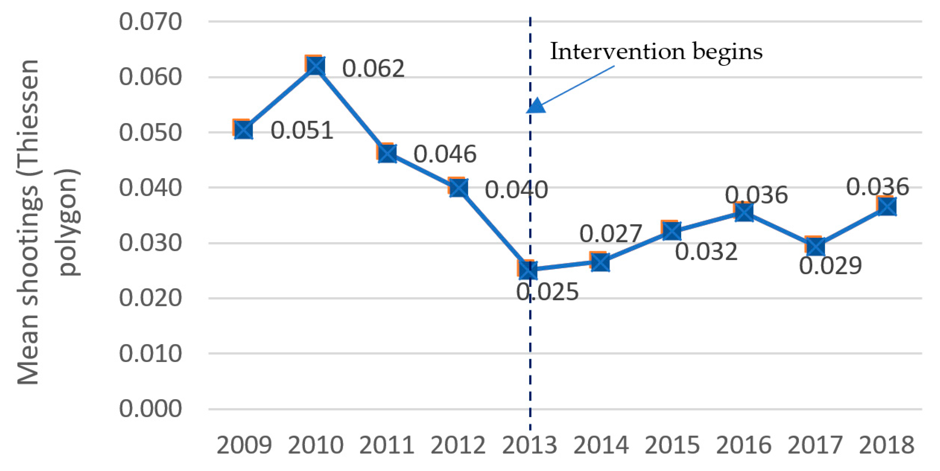
3.1. Distribution of Shooting Victims across the Target Area and Time–Descriptive Results

Table 2 displays the distribution of shootings by TP in the study area. Shootings are a relatively rare occurrence for most TPs. A little over 80% of TPs experienced zero shooting victims between 2009 and 2018. Less than 1% of TPs had six or more shooting victims. Figure 2 shows the annual mean number of shootings in TPs across the ten-year time frame. Interestingly, a visual inspection of the graph shows a downward trend in the mean of shootings within TPs before the intervention began, with a slow upward trend after the implementation of Philadelphia Focused Deterrence, but it does not reach its 2010 high of 0.062 victims per TP.

3.2. Comparison of the Pre-Implementation Period to the Post-Implementation Period

The maps in Figure 3a,b show the locations of hot and cold spots produced for each three-year period comparing pre-intervention shooting victim hot spots with those present in the latter part of the strategy’s tenure (post-implementation). The darkest colored areas are statistical hot spots defined using the strictest confidence level (99th percentile). Table 3 displays the comparison statistics generated from the production of the two maps in Figure 3. The top row of the table shows the similarity and association statistics when including the map areas that are not statistically significant hot or cold spots versus the bottom row that compares only the hot and cold spot areas that met the significance level thresholds (at least 90th percentile confidence level).
The similarity statistic for the significant features indicates that roughly half the significant features changed in their density between the pre-implementation and the post-implementation periods. A visual inspection of Figure 3 suggests there were many areas that experienced changes. For instance, the hot spot that was east of Broad Street in the pre-intervention map greatly diminished in the post-implementation period, with only 14 TPs deemed a hot spot in the area east of Broad Street. The pre-implementation hot spot in the far northeast section of the map, spanning three TPs east of Delaware Avenue, is not present at all in the post-implementation period. The large hot spot west of Broad Street appears to have shrunk on its southeasterly edge by the post-intervention period but grew on the northwestern side (west after the intervention). In addition, there is a statistically significant cold spot in the pre-intervention period, but this cold spot is not present in the post-intervention period. The second analysis—categorizing the hot spot patterns that emerge over a ten-year period—was designed to help make sense of the changes, increasing interpretability; the results are discussed below.

3.3. Spatiotemporal Patterns

The Space-Time cube aggregated the locations of shooting victims into 2783 TPs over ten time step intervals representing calendar years (i.e., 2009 through 2018). Of the 2783 locations, 92 (3.31%) contain at least one shooting victim for at least one time step interval. The emerging hot spot analysis calculates the nonparametric Mann–Kendall statistic to test for increasing or decreasing trends by evaluating count values for the locations in each one-year time step interval. The overall trend statistic showed a decreasing trend in South Philadelphia during the ten-year time frame, but it did not reach statistical significance (Mann–Kendall statistic = −1.43, p < 0.152). A look back at Figure 2 might provide insight into why this statistic did not reach statistical significance—the annual mean (i.e., average) of shootings, which had been decreasing early on in the time series across all of South Philadelphia, began to increase midway through the time series (but never reached the high mean seen at the beginning in 2009 and 2010). Table 4 summarizes the patterns detected. Of the eight possible hot/cold patterns in the categorization schema (see Table 1), the analysis revealed ninety-three hot spots categorized into four patterns: fourteen new hot spots; twenty-three consecutive; one persistent; and fifty-three sporadic. There were no cold spots.
The output map of these categorical representations is shown in Figure 4 (panels a and b). To assess which categories are present vs. absent, the map’s legend includes all possible categories, but only the four patterns mentioned above emerged. As a reminder, the ten-year period begins roughly three years before the first call-in notification meeting was held (with representatives of at least four street groups attending) and concludes in December 2018, the year when Philadelphia Focused Deterrence had fully ceased to operate (although it was slowly tapering off from late 2016 through 2017).
In addition to no cold spot patterns, the following hot spot patterns did not occur: intensifying, historical, diminishing, or oscillating hot spots. A visual inspection of the map reveals that the 14 new hot spot TPs were generally spread near locations that had hot spots west of Broad Street in the pre-implementation period (Figure 3). There are no new hot spots east of Broad Street. The one persistent hot spot identified is located west of Broad Street and is surrounded by consecutive and sporadic hot spots, with at least three new hot spots on the outer edges of the associated large cluster. There is a large cluster comprising seven TPs in the northern region of the target area, with each TP characterized as consecutive. Overall, considering the changes in light of expected findings for a place-based and targeted gun violence reduction strategy, these findings include positive changes but also reveal new locations and some generally stable micro-locations of shootings. The findings are discussed in more detail in the discussion.

4. Discussion

This study sought to examine the extent to which the spatiotemporal patterns of shootings changed during and after the implementation of Philadelphia Focused Deterrence in South Philadelphia. We asked: What patterns emerged? Did any hot spots significantly diminish? Were there any unexpected findings, such as new hot spots? We hypothesized that the intervention would be associated with diminishing hot spots over time and little movement of hot spots (i.e., new hot spots appearing in other locations). An emerging hot spot analysis technique was employed to identify Space-Time clusters and categorize changes in clusters to facilitate interpretation. The analysis considered a wide range of patterns that can potentially occur. Apart from a “no-pattern detected category”, the method used tests 16 possible categories—providing a nuanced assessment of both hot and cold changes—that could show positive movement representing fewer, less dense, and less stable areas of gun violence, or negative outcomes with regard to gun violence, signifying stable, more, more dense areas, or potential displacement of gun violence.
Of the sixteen possible patterns that can be detected by the analytical technique, only four were evident, and all were related to hot spots (versus cold)—“new”, “consecutive”, “persistent”, and “sporadic”. We hypothesized that we would see diminishing hot spots (i.e., where an area is a significant hot spot for 90% of the intervals but the intensity of the clustering in each time step is decreasing significantly) or other patterns related to areas becoming less hot/ intense. Although the current results did not show any statistically significant diminishing hot spots, with the exception of the four new hot spots and one persistent hot spot, the patterns that emerged across the ten-year period were generally positive. There were no intensifying or historical hot spots, indicating that micro-locations did not significantly gain more density (i.e., more shootings) over time or stay consistently hot, except for the most recent time bin/year (2018), respectively.
With regard to finding no (zero) diminishing hot spots, it is possible that a diminishing pattern would be detected if six-month time bins had been used instead of one-year time bins or if the time span for the emerging hot spot analysis ended before 2018, during a time when the intervention was operating with strong fidelity. By late 2018, the City of Philadelphia had a new mayor (whose tenure began in 2016) and a new district attorney (i.e., local prosecutor). At that time, city leaders had begun to discuss how to revitalize the strategy and start anew.2
The generally positive findings should be coupled with potentially negative results showing the emergence of 14 new hot spots. As mentioned in the results section, some of these new locations were edges of areas that were statistically significant hot spots in the pre-intervention period (Figure 3). These spatial changes could be indicative of the displacement of shootings. It is important to note that a new hot spot does not necessarily signify shootings in the focal polygon depicting the pattern type; it could be indicating a high “local mean” for that bin because the designation of a hot spot takes into consideration its Space-Time neighbors. Although not shown, the underlying data reveal that six (6) of the fourteen focal TPs designated “new” hot spots had zero shootings across the ten-year period; instead, it is the adjacent TPs that experienced the increase over time. Nevertheless, the designation of “new” represents a significant increase in the mean number of shootings in the latter year of the time series, likely worthy of stakeholders scrutinizing the increase for intervention purposes (assuming multiple shootings are not linked to one mass shooting event). In one of the TPs designated a new hot spot, there had been one shooting in each of the three early years in the time series (2011 through 2013), but then the TP experienced zero shootings until 2018 when it had four shootings in 12 months and then one in 2019. Because the measure of shootings represents the number of victims, it may be that these four shootings were tied to one criminal event. Regardless, the three shooting incidents in such a small area (roughly 0.02 square kilometers) across three years should have warranted attention by public safety leaders in the early years of the time frame. Perhaps sustained investment at that time could have prevented the resurgence of gun violence in later years, regardless of whether violence was displaced via mechanisms involving the same actors or new actors and behaviors not tied to groups or group members. Recognizing diminishing patterns early allows for proactive measures to sustain the positive trend, and there are various ways to do so, including addressing root causes, engaging with the community, or adjusting policing strategies. Importantly, the simple-to-understand data fields generated by the emerging hot spot analysis (e.g., basic descriptive statistics on the polygon units) can be used by public safety strategists interested in fine-tuning interventions or new strategizing and resource provision at micro-locations.
Because we cannot be certain that any crime trends, the movement of hot spots or the emergence of new hot spots detected in the current study resulted from (i.e., was caused by) the intervention, future evaluative studies of policing interventions should couple descriptive analyses, such as those with a rigorous quantitative and qualitative assessment of displacement. Mixed method study designs help contextualize results from findings showing that displacement likely occurred. Nevertheless, descriptive analyses can play a critical role in understanding the dynamics of gun violence, guiding interventions, and informing and prioritizing policy choices. Descriptive analyses also provide a valuable starting point for further research. For instance, deep historical analyses of time series that span longer than a decade, including predictive risk analyses, may help uncover distinctive factors that can be addressed by prevention efforts. In addition, extending analyses to the entire city or comparing with other cities can further an understanding of the factors associated with gun violence risk and resiliency.
In addition to the current study’s inability to infer causality, other limitations should be mentioned. First, the measure of shooting victims used in the analyses comprises all shootings in the target area, not a subset of shootings tied to gang motivations and/or members. Hence, the changes and patterns that emerged over time capture all motives and individuals engaged in shooting behavior, not just individuals affiliated with street groups. Relatedly, we did not have access to street group set spaces (i.e., territories of activity/core spaces where the groups hang out), which would have enabled us to put forth new theories for hypothesis testing about street group processes of the particular street groups targeted by focused deterrence. We do know, however, according to the prior evaluations, that four of the street groups (out of fourteen) that were targeted and received the intervention continued shooting at the same rate or even at higher levels after the implementation of the intervention. The picture that emerges from the analyses herein generally comports with those findings, showing changes in the positive direction but also some negative. In Philadelphia, most group/gang-related information is considered “intelligence” information by Pennsylvania law, and hence, law enforcement agencies tightly restrict (and sometimes deny) research access to group/gang data. Furthermore, Philadelphia’s law enforcement agencies do not include “gang-related” as an official motive in public data on homicides and shootings, and hence, any attempt to collect this information likely means new or prospective data collection and/or time-consuming city-level processes to set up data sharing agreements. Most urban police agencies across the United States similarly protect and restrict access to these types of data elements (Katz 2003).
Even without access to Philadelphia street group motives, membership, and set space data, the current findings reveal informative patterns. The different patterns highlight how policing strategies could benefit from micro-level analyses, such as the ones included here. This type of nuanced categorization can help law enforcement agencies tailor interventions to better address the different pattern types. Different strategies may be needed to address violence that is on the rise, persistently high, or showing signs of decline. Even though group-based crime is very difficult to observe and measure, the current study’s small-area analyses, using Thiessen polygons, generated a range of pattern types, reminding us, as past studies have done (see, for instance, Brantingham et al. 2019; Walter et al. 2023a; Weisburd et al. 2013), that examining changes in violence at very small spatial scales is critical to understanding and addressing criminal behavior and street groups.

Author Contributions

Conceptualization, J.A.B. and C.G.R.; methodology, J.A.B. and C.G.R.; formal analysis, J.A.B.; writing—original draft preparation, J.A.B. and C.G.R.; writing—review and editing, J.A.B. and C.G.R.; supervision, C.G.R.; project administration, C.G.R.; funding acquisition, C.G.R. All authors have read and agreed to the published version of the manuscript.

Funding

This research was funded by the Fund for a Safer Future (#013166-2020-12-21).

Institutional Review Board Statement

The Temple University Institutional Review Board ruled (13 December 2021) that this study does not constitute human subjects research according to federal definitions set forth.

Informed Consent Statement

Not applicable.

Data Availability Statement

All shooting victim data used in the analyses are available publicly at https://opendataphilly.org (accessed on 10 January 2023).

Acknowledgments

We would like to thank Karissa Pelletier for reviewing the manuscript, Alese Wooditch for providing assistance with ArcGIS, and our colleagues at the Philadelphia District Attorney’s Office who assisted with grant proposal preparation: Oren Gur, Mariel Delacruz, and (then Assistant District Attorney) Michael Hollander. We also acknowledge the anonymous peer reviewers who provided feedback. Last, but not least, we thank our colleagues at the Philadelphia Police Department for answering our questions.

Conflicts of Interest

The authors declare no conflict of interest. The funders had no role in the design of the study; in the collection, analyses, or interpretation of data; in the writing of the manuscript; or in the decision to publish the results.

Notes

1
We use the terms “street group” to denote groups of teenagers and young adults engaged in typically group-based violence, that tend to be loosely structured, often with informal roles of leadership. This definition sets these groups apart from more organized groups such as drug trafficking organizations, or motorcycle gangs. Not all members of street groups engage in violent behavior. They most often have transient leadership and membership. In some aspects, this term can be used interchangeably with “street gangs”. In Philadelphia, local leaders referred to these groups as “gangs”.
2

References

  1. An, Li, Ming-Hsiang Tsou, Stephen E. S. Crook, Yongwan Chun, Brian Spitzberg, J. Mark Gawron, and Dipak K. Gupta. 2015. Space-Time Analysis: Concepts, Quantitative Methods, and Future Directions. Annals of the Association of American Geographers 105: 891–914. [Google Scholar] [CrossRef]
  2. Ashok, S., Malik Zaka Ullah, Nandakumar Vadivelu, Mohammed Tariqul Islam, Safa Nasereddin, and Wajahat Zafar Khan. 2022. Surveillance of COVID-19 Using Geospatial Data: An Emergency Department Perspective. Dubai Medical Journal 5: 1. [Google Scholar] [CrossRef]
  3. Bowers, Kate J., Shane D. Johnson, Rob T. Guerette, Lucia Summers, and Suzanne Poynton. 2011. Spatial Displacement and Diffusion of Benefits among Geographically Focused Policing Initiatives: A Meta-analytical Review. Journal of Experimental Criminology 7: 347–74. [Google Scholar] [CrossRef]
  4. Braga, Anthony A., and David L. Weisburd. 2012. The Effects of Focused Deterrence Strategies on Crime: A Systematic Review and Meta-Analysis of The Empirical Evidence. Journal of Research in Crime and Delinquency 49: 323–58. [Google Scholar] [CrossRef]
  5. Braga, Anthony A., and David M. Kennedy. 2021. A Framework for Addressing Violence and Serious Crime: Focused Deterrence, Legitimacy, and Prevention. Cambridge: Cambridge University Press. [Google Scholar]
  6. Braga, Anthony A., David Weisburd, and Brandon Turchan. 2018. Focused Deterrence Strategies and Crime Control: An Updated Systematic Review and Meta-Analysis of The Empirical Evidence. Criminology and Public Policy 17: 205–50. [Google Scholar] [CrossRef]
  7. Braga, Anthony A., Greg Zimmerman, Lisa Barao, Chelsea Farrell, Rod K. Brunson, and Andrew V. Papachristos. 2019. Street Gangs, Gun Violence, and Focused Deterrence: Comparing Place-based and Group-based Evaluation Methods to Estimate Direct and Spillover Deterrent Effects. Journal of Research in Crime and Delinquency 56: 524–62. [Google Scholar] [CrossRef]
  8. Braga, Anthony A., Robert Apel, and Brandon C. Welsh. 2013. The Spillover Effects of Focused Deterrence on Gang Violence. Evaluation Review 37: 314–42. [Google Scholar] [CrossRef] [PubMed]
  9. Brantingham, P. Jeffrey, Matthew Valasik, and George E. Tita. 2019. Competitive Dominance, Gang Size and the Directionality of Gang Violence. Crime Science 8: 7. [Google Scholar] [CrossRef]
  10. Chainey, Spencer, and Jerry Ratcliffe. 2005. GIS and Crime Mapping. London: Wiley. [Google Scholar]
  11. Decker, Scott H., and David C. Pyrooz, eds. 2015. Street Gangs, Terrorists, Drug Smugglers, and Organized Crime. In The Handbook of Gangs. Hoboken: John Wiley & Sons, Inc. [Google Scholar] [CrossRef]
  12. Dou, Weibei, Yuan Ren, Qian Wu, Su Ruan, Yanping Chen, Daniel Bloyet, and Jean-Marc Constans. 2007. Fuzzy kappa for the agreement measure of fuzzy classifications. Neurocomputing 70: 726–34. [Google Scholar] [CrossRef]
  13. Fatima, Munazza, Sana Arshad, Ibtisam Butt, and Saba Arshad. 2021. Geospatial Clustering and Hot Spot Detection of COVID-19 Incidence in 2020: A Global Analysis. International Journal of Geospatial and Environmental Research 8: 4. [Google Scholar]
  14. Fox, Andrew M., and Kenneth J. Novak. 2018. Collaborating to Reduce Violence: The Impact of Focused Deterrence in Kansas City. Police Quarterly 21: 283–308. [Google Scholar] [CrossRef]
  15. Fox, Bryanna, Scott F. Allen, and Alexander Toth. 2022. Evaluating the Impact of Project Safe Neighborhoods (PSN) Initiative on Violence and Gun Crime in Tampa: Does it Work and Does it Last? Journal of Experimental Criminology 18: 543–67. [Google Scholar] [CrossRef]
  16. Getis, Arthur, and J. K. Ord. 1992. The Analysis of Spatial Association by Use of Distance Statistics. Geographic Analysis 24: 189–206. [Google Scholar] [CrossRef]
  17. Gravel, Jason, Matthew Valasik, Joris Mulder, Roger Leenders, Carter Butts, P. Jeffrey Brantingham, and George E. Tita. 2023. Rivalries, Reputation, Retaliation, and Repetition: Testing Plausible Mechanisms for the Contagion of Violence Between Street Gangs Using Relational Event Models. Network Science 11: 324–50. [Google Scholar] [CrossRef]
  18. Hatten, David, and Eric L. Piza. 2022. When Crime Moves Where Does It Go? Analyzing the Spatial Correlates of Robbery Incidents Displaced by a Place-based Policing Intervention. Journal of Research in Crime and Delinquency 59: 128–62. [Google Scholar] [CrossRef]
  19. He, Zhanjun, Rongqi Lai, Zhipeng Wang, Huimin Liu, and Min Deng. 2022. Comparative Study of Approaches for Detecting Crime Hotspots with Considering Concentration and Shape Characteristics. International Journal of Environmental Research and Public Health 19: 14350. [Google Scholar] [CrossRef] [PubMed]
  20. Herrmann, Christopher R. 2013. Street-Level Spatiotemporal Crime Analysis: Examples from Bronx County, NY (2006–2010). In Crime Modeling and Mapping Using Geospatial Technologies Series. Edited by Michael Leitner. Dordrecht: Springer. [Google Scholar] [CrossRef]
  21. Howell, James. C. 2018. What Works with Gangs: A Breakthrough. Criminology and Public Policy 17: 991. [Google Scholar] [CrossRef]
  22. Hyatt, Jordan M., James A. Densley, and Caterina G. Roman. 2021. Social Media and the Variable Impact of Violence Reduction Interventions: Re-Examining Focused Deterrence in Philadelphia. Social Sciences 10: 147. [Google Scholar] [CrossRef]
  23. Katz, Charles. 2003. Issues in the Production and Dissemination of Gang Statistics: An Ethnographic Study of a Large Midwestern Police Gang Unit. Crime and Delinquency 49: 485–516. [Google Scholar] [CrossRef]
  24. Kennedy, David M. 2011. Don’t Shoot: One Man, a Street Fellowship, and the End of Violence in Inner-City America. New York: Bloomsbury. [Google Scholar]
  25. Klein, Malcolm W., and Cheryl L. Maxson. 2006. Street Gang Patterns and Policies. New York: Oxford University Press. [Google Scholar]
  26. Kortas, Fabiënne, Alexander Grigoriev, and Giulia Piccillo. 2022. Exploring Multi-scale Variability in Hotspot Mapping: A Case Study on Housing Prices and Crime Occurrences in Heerlen. Cities 128: 103814. [Google Scholar] [CrossRef]
  27. Lane, Roger. 1989. Roots of Violence in Black Philadelphia, 1860–1900. Cambridge: Harvard University Press. [Google Scholar]
  28. Lawton, Brian A., Ralph B. Taylor, and Anthony J. Luongo. 2005. Police Officers on Drug Corners in Philadelphia, Drug Crime, and Violent Crime: Intended, Diffusion, and Displacement Impacts. Justice Quarterly 22: 427–51. [Google Scholar] [CrossRef]
  29. Leasure, Peter, Hunter M. Boehme, Robert J. Kaminski, Amie R. Scheidegger, P. J. Verrecchia, Kirsten L. Witherup, Michelle Baughman, Scott Nadzom, and Jada Easley. 2023. Evaluation of the York City Police Department’s Group Violence Initiative (13 September 2023). Ohio State Legal Studies Research Paper No. 804. Columbus: Drug Enforcement and Policy Center. Available online: https://ssrn.com/abstract=4571341 (accessed on 17 July 2023). [CrossRef]
  30. Mamiit, Rusyan Jill, John Yanagida, and Tomoaki Miura. 2021. Productivity Hot Spots and Cold Spots: Setting Geographic Priorities for Achieving Food Production Targets. Frontiers in Sustainable Food Systems 5: 727484. [Google Scholar] [CrossRef]
  31. Morckel, Victoria, and Noah Durst. 2021. Using Emerging Hot Spot Analysis to Explore Spatiotemporal Patterns of Housing Vacancy in Ohio Metropolitan Statistical Areas. Urban Affairs Review 59: 309–28. [Google Scholar] [CrossRef]
  32. National Network for Safe Communities (NNSC). 2022. Support and Outreach White Paper. Available online: https://www.nnscommunities.org/wp-content/uploads/2022/03/Support-and-Outreach-White-Paper.pdf (accessed on 1 November 2023).
  33. Nepomuceno, Thyago Celso C., and Ana Paula Cabral Seixas Costa. 2019. Spatial Visualization on Patterns of Disaggregate Robberies. Operational Research 19: 4. [Google Scholar] [CrossRef]
  34. Piquero, Alex R., David P. Farrington, and Alfred Blumstein. 2007. Key Issues in Criminal Career Research: New Analyses of the Cambridge Study in Delinquent Development. Cambridge: Cambridge University Press. [Google Scholar] [CrossRef]
  35. Ratcliffe, Jerry H. 2004. Geocoding Crime and a First Estimate of a Minimum Acceptable Hit Rate. International Journal of Geographical Information Science 18: 61–72. [Google Scholar] [CrossRef]
  36. Roman, Caterina G. 2021. An Evaluator’s Reflections and Lessons Learned about Gang Intervention Strategies: An Agenda for Research. Journal of Aggression, Conflict and Peace Research 13: 148–67. [Google Scholar] [CrossRef]
  37. Roman, Caterina G., Megan Forney, Jordan M. Hyatt, Hannah J. Klein, and Nathan W. Link. 2020. Law Enforcement Activities of Philadelphia’s Group Violence Intervention: An Examination of Arrest, Case Processing, and Probation Levers. Police Quarterly 23: 232–61. [Google Scholar] [CrossRef]
  38. Roman, Caterina G., Nathan W. Link, Jordan M. Hyatt, Avinash Bhati, and Megan Forney. 2019. Assessing the Gang-level and Community-level Effects of the Philadelphia Focused Deterrence Strategy. Journal of Experimental Criminology 15: 499–527. [Google Scholar] [CrossRef]
  39. Sweet, Sarah, Gabriel Alexander, and Russell Alexander. 2020. The Death of Freddie Gray and Its Impact on Homicides in Baltimore and Maryland. Journal of Forensic Sciences 65: 5. [Google Scholar] [CrossRef]
  40. Taniguchi, Travis A., Jerry H. Ratcliffe, and Ralph B. Taylor. 2011. Gang Set Space, Drug Markets, and Crime Around Drug Corners in Camden. Journal of Research in Crime and Delinquency 48s: 327–63. [Google Scholar] [CrossRef]
  41. Taylor, Bruce, Christopher S. Koper, and Daniel J. Woods. 2011. A Randomized Controlled Trial of Different Policing Strategies at Hot Spots of Violent Crime. Journal of Experimental Criminology 7: 149–81. [Google Scholar] [CrossRef]
  42. Thornberry, Terence P., Adrienne Freeman-Gallant, Alan J. Lizotte, Marvin D. Krohn, and Carolyn A. Smith. 2003. Linked Lives: The Intergenerational Transmission of Antisocial Behavior. Journal of Abnormal Child Psychology 31: 171–84. [Google Scholar] [CrossRef] [PubMed]
  43. Topalli, Volkan, Richard Wright, and Robert Fornango. 2002. Drug Dealers, Robbery and Retaliation: Vulnerability, Deterrence and the Contagion of Violence. British Journal of Criminology 42: 337–51. [Google Scholar] [CrossRef]
  44. Vadlamani, Srikanth, and Mahdi Hashemi. 2020. Studying the Impact of Streetlights on Street Crime Rate Using Geo-Statistics. Paper presented at the 2020 IEEE 21st International Conference on Information Reuse and Integration for Data Science (IRI), Las Vegas, NV, USA, August 11–13; pp. 231–36. [Google Scholar] [CrossRef]
  45. Van Der Zee, Egbert, Dario Bertocchi, and Dominique Vanneste. 2020. Distribution of Tourists within Urban Heritage Destinations: A Hot Spot/Cold Spot Analysis of Trip Advisor Data as Support for Destination Management. Current Issues in Tourism 23: 102973. [Google Scholar] [CrossRef]
  46. Walter, Rebecca J., Marie Skubak Tillyer, Alex Ramiller, and Arthur Acolin. 2023a. Scaling Down from the Neighborhood in Urban Planning Research and Practice: The Potential Benefits of a Micro-Scale Focus. Journal of Planning Education and Research. [Google Scholar] [CrossRef]
  47. Walter, Rebecca J., Marie Skubak Tillyer, and Arthur Acolin. 2023b. Spatiotemporal Crime Patterns Across Six U.S. Cities: Analyzing Stability and Change in Clusters and Outliers. Journal of Quantitative Criminology 39: 951–74. [Google Scholar] [CrossRef]
  48. Weisburd, David, Elizabeth R. Groff, and Sue-Ming Yang. 2013. The Criminology of Place: Street Segments and Our Understanding of the Crime Problem. Oxford: Oxford University Press. [Google Scholar] [CrossRef]
  49. Zerbe, Kevin, Chris Polit, Stacey McClain, and Tim Cook. 2022. Optimized Hot Spot and Directional Distribution Analyses Characterize the Spatiotemporal Variation of Large Wildfires in Washington, USA, 1970−2020. International Journal of Disaster Risk Science 13: 139–50. [Google Scholar] [CrossRef]
Figure 1. The focused deterrence intervention area, Philadelphia, PA.
Socsci 13 00119 g001
Figure 2. Mean of shooting victims in Thiessen polygons, South Philadelphia, PA, 2009 to 2018.
Socsci 13 00119 g002
Figure 3. Results of optimized hot spot analysis comparing focused deterrence pre-intervention and post-intervention periods, South Philadelphia, PA. (a) shows the pre-intervention period (2009–2011); (b) shows the post-intervention period (2015–2017).
Socsci 13 00119 g003
Figure 4. Emerging hot spot analysis using Thiessen polygons, South Philadelphia, PA. (Panel (a) shows the full view; panel (b) shows the zoomed-in view).
Socsci 13 00119 g004
Table 1. Definitions of eight possible hot and cold spot patterns; emerging hot spot analysis.
PatternDefinition
NewLocation identified as a statistically significant hot (cold) shooting spot but not previously identified as a significant hot (cold) spot.
ConsecutiveLocation with a single uninterrupted run of statistically significant hot (cold) spot bins in final time steps. Except for the final run, the location was never a significant hot (cold) spot.
IntensifyingThe location has been a statistically significant hot (cold) spot for 90% of the time in a 10-year span. In addition, the intensity of clustering of high shooting victim counts for each time period increased (decreased) overall, and the increase (decrease) was significant.
PersistentThe location has been a statistically significant hot (cold) spot for 90% of time step intervals, with no discernible trend indicating an increase or decrease in the intensity of clustering of shooting victims over time.
DiminishingThe location has been a statistically significant hot (cold) spot for 90% of the time step intervals, including the final time step. In addition, the intensity of clustering in each time step is decreasing (increasing) overall, and the decrease (increase) is significant.
SporadicLocation is an on-again then off-again hot (cold) spot. Less than 90% of time step intervals have been statistically significant hot (cold) spots and none of the time step intervals have been significant cold (hot) spots.
OscillatingA statistically significant hot (cold) spot for the final time step interval that has a history of also being a significant cold (hot) spot during a prior time step. Less than 90% of the time step intervals have been statistically significant hot (cold) spots.
HistoricalThe most recent time period is not hot (cold), but at least 90% of time step intervals have been significant hot (cold) spots.
Notes: This table is derived from information provided by ESRI, which can be found at https://desktop.arcgis.com/en/arcmap/latest/tools/space-time-pattern-mining-toolbox/learnmoreemerging.htm (accessed on 11 October 2023). All mentions of “significant” represent statistical significance.
Table 2. Number of shootings in Thiessen polygons, South Philadelphia, PA, 2009 to 2018.
N of ShootingsN of TPs%Cumulative %
0224680.7080.70
129810.7191.41
21063.8195.22
3612.1997.41
4301.0898.49
5180.6599.14
6130.4799.60
7–9100.3699.96
10+10.04100.00
Total2783100100.00
Table 3. Similarity and association statistics comparing shootings across two time periods, South Philadelphia, PA.
ComparisonComparison SettingsSimilarityExpected SimilaritySpatial Fuzzy Kappa
Pre-implementation vs. post-implementationAll features0.8860.7260.583
Significant features only0.4790.2190.333
Notes: Pre-implementation period = 2009–2011; post-implementation period = 2015–2017; the spatial fuzzy Kappa statistic is the association between the hot spot analysis variables, calculated by scaling the similarity value by its expected value.
Table 4. Hot spot categories across Thiessen polygons, 2009–2018, South Philadelphia, PA (N = 2783).
Pattern Typen (%)
New hot spot14 (0.5%)
Consecutive hot spot23 (0.8%)
Persistent hot spot1 (0.0)
Sporadic hot spot54 (1.9)
No pattern detected2691 (96.7)
Disclaimer/Publisher’s Note: The statements, opinions and data contained in all publications are solely those of the individual author(s) and contributor(s) and not of MDPI and/or the editor(s). MDPI and/or the editor(s) disclaim responsibility for any injury to people or property resulting from any ideas, methods, instructions or products referred to in the content.

