Article

The Australian Roadkill Reporting Project—Applying Integrated Professional Research and Citizen Science to Monitor and Mitigate Roadkill in Australia

Sydney School of Veterinary Science, University of Sydney, Sydney, NSW 2006, Australia
*
Author to whom correspondence should be addressed.
Animals 2020, 10(7), 1112; https://doi.org/10.3390/ani10071112
Submission received: 9 May 2020 / Revised: 19 June 2020 / Accepted: 24 June 2020 / Published: 29 June 2020
(This article belongs to the Section Wildlife)

Abstract

:

Simple Summary

Australia has no database of national roadkill. The current research project fills that knowledge gap by developing a roadkill reporting application that enables professional and citizen scientists to record photographs of roadkill with location, time and date. This embodies the concept of ‘One Welfare’ as it affects humans, animals and the environment. Uploaded to a website, these data can identify roadkill hotspots, tabulate species of animals killed and potentially be used for ecological studies of roadkill numbers, species distribution, population trends, animal behaviour and disease. Initial results indicate that mammal roadkill mostly occurs at night and that of birds and reptiles during daytime. Mammals make up three-quarters of the roadkill recorded and this includes endangered species. Two examples of roadkill hotspots are shown in Queensland and Tasmania. These will enable further research to suggest how roadkill mitigation measures may be optimally employed.

Abstract

Australia has no national roadkill monitoring scheme. To address this gap in knowledge, a roadkill reporting application (app) was developed to allow members of the public to join professional researchers in gathering Australian data. The app is used to photograph roadkill and simultaneously records the GPS location, time and date. These data are uploaded immediately to a website for data management. To illustrate the capacity to facilitate cost-effective mitigation measures the article focuses on two roadkill hotspots—in Queensland and Tasmania. In total, 1609 reports were gathered in the first three months of the project. They include data on mammals (n = 1203, 75%), birds (n = 125, 7.8%), reptiles (n = 79, 4.9%), amphibians (n = 4, 0.025%), unidentified (n = 189, 11.8%) and unserviceable ones (n = 9). A significant finding is variance in the distribution of mammals and birds at different times of day. These findings reflect diurnal variation in the activity levels of different species and underline the need for data on a targeted species to be collected at appropriate times of day. By continuing to facilitate roadkill monitoring, it is anticipated that the data generated by the app will directly increase knowledge of roadkill numbers and hotspots. Indirectly, it will provide value-added information on animal behaviour, disease and population dynamics as well as for species distribution mapping.

1. Introduction

Roadkill is a term that encompasses all mammals, birds, reptiles and amphibians that are killed by vehicles on roads. Although Australia lacks national data on roadkill, there have been state-based studies, notably in New South Wales [1,2,3,4,5], Tasmania [6], Victoria [7] and South Australia [8]. Dating from 1972 through to 2008, these were conducted by professional researchers. However, emergent technologies, such as mobile phones, mean that the collection of reliable roadkill data has become possible for volunteer citizens. Such volunteers have become known as citizen scientists, a term coined in 1995 by Rick Bonney in the USA [9] and Alan Irwin in the UK [10]. These technologies bring with them many advantages, particularly when the area of environment to be studied is as geographically broad as Australia. Citizen scientists can gather data on a scale beyond the reach of most research budgets.
It is acknowledged that there are problems and pitfalls with the recruitment, motivation and retention of volunteers, ensuring safe working practices and the quality of the data produced [11,12], but these challenges can be overcome [13]. An increase in citizen science projects from 100 in 2011 to 700 in 2018 is reported by SciStarter [14] and this is reflected in the increasing number of peer-reviewed papers published annually that use or include data from citizen scientists [15,16].
Examples of projects that use such data include the doglogbook, developed by the dogmanship team at the Sydney School of Veterinary Science, University of Sydney, Australia [17]. This aims to support evidence-based assessments of dog quality of life and enhance dog welfare in clinical practice. Outside the realm of domesticated animals, other examples are Birdata, run by Birdlife Australia [18], and eBird, run by Cornell University [19]—both of which collect information on birdlife supplied by citizen scientists.
Records made whenever and wherever an observer observes a target, such as roadkill, are called roving records [13]. National roadkill monitoring projects using roving reports are in place across the globe, but some, being fairly undersubscribed, are limited in their scope. Examples include ‘Project Splatter’ [20] and ‘Mammals on Road’ [21]—both of which are in the UK—‘Roadkills’ in India [22], ‘Roadkill Observation Network’ in Japan [23], ‘Animals under Wheels’ in Belgium [24], Srazenazver.cz in the Czech Republic [25] and ‘Projekt Roadkill’ in Austria [26].
The challenge of obtaining reliable data gathered by volunteers with only basic training can be overcome by emergent smartphones and tablets and the development of applications (apps) that can be downloaded to them. Many smartphones have in-built GPS receivers and can access environmental information through open-source databases such as Google Maps that offer satellite imagery, aerial photography, street maps, 360° interactive panoramic views of streets, real-time traffic conditions, and route planning for traveling by foot, car, bicycle, air or public transportation. The technological advantage of obtaining accurate data through apps is that no knowledge of computer technology is required to use them and they are mobile. It has been shown that these apps can be used to improve data collection by both professional researchers [27] and citizen scientists [28,29].
Potential shortfalls in the collection of accurate ecological data include the inaccurate recording of time and location, recording duplication of data, incorrect identification of subjects and even loss of data records. For roadkill studies specifically, numerous constraints on the collection of data reflect temporal, spatial and taxonomic challenges that can cause gaps in knowledge. If citizen scientists are to be used in a roadkill monitoring research programme, the method of data collection must be as fail proof as possible and produce data that are incontrovertible.
In essence, this means that a citizen scientist engaged in recording roadkill needs no skills other than to be able to spot roadkill and then use the app as directed. A photograph of the roadkill that is digitally stamped with GPS location, time and date and then uploaded to a website would meet these criteria. In contrast to relying on paper hard copy, the use of a tablet or smartphone has the advantage over paper hard copy that the observations are recorded swiftly and accurately, and are automatically uploaded to a website. If no mobile coverage is available, the app can record the GPS via satellite and then upload recorded roadkill data to a website once mobile coverage is obtained. The user does not need to separately record a GPS from a tracker, the time and date from a secondary source and then write the results into a field notebook—no easy task in wind, rain or snow. These notes have then to be copied to a website, a process that may allow errors to creep in.
The current project followed the exemplar of mobile application for recording roadkill reported in other countries including the UK [20], USA [30], Belgium and Austria [31] Columbia [32] and Tanzania [33]. The functional specifications were for the current Australian Roadkill Reporting Project (ARRP), using the Roadkill Reporter App (RRApp), to track Australian roadkill by means of a smartphone or tablet by a researcher or citizen scientist.
The long-term aim of the project was to provide an estimate of the scale of the national roadkill problem and produce a baseline of annual roadkill data with which future roadkill data could be compared.

2. Materials and Methods

2.1. A Review of Roadkill Reporting Applications

A review of the functionality of existing roadkill reporting apps, undertaken in early 2017, demonstrated that all were inadequate for the purpose of this study or suffered from prohibitive leasing costs. A new app, named the Roadkill Reporter App (RRApp), was, therefore, developed locally.

2.2. Features and Functionality of the RRApp

It was important that the RRApp fulfilled the following criteria:
  • Must be easy to use, requiring no technical knowledge to operate;
  • Freely available;
  • Portable and accessible;
  • Functional on Apple iOS and AndroidTM mobile operating system;
  • Data on the app must be able to be uploaded to a secure website via a web facility to collate, store and allow access through a website interface to data submitted through use of the mobile application;
  • Data collected must include a photograph and GPS, time and date;
  • Users must have the ability to review trends by accessing the website;
  • Users must be able to make notes to accompany a roadkill photograph;
  • Users must remain anonymous.
The website for monitoring the app was required to be hosted in Australia if possible.

2.3. Usage and Testing of the RRApp

The app allows the use of personal mobile devices to take a photograph of roadkill and submit it to a cloud-based database of sightings along with the time of day and GPS location.
Once developed, the app was subjected to testing by a mixed group of volunteers (n = 14) of different gender, age and familiarity with the use of information technology. Feedback from this testing resulted in refinements being introduced to ensure the RRApp was user-friendly for citizen scientists of different abilities. The participants were required to take a photograph of the roadkill, categorise it as mammal, bird, other or splat (unidentifiable roadkill) and then submit the report. The app ensures that the GPS coordinates and time of day are automatically submitted.
The RRApp was further tested in a pilot study during a research trial of a virtual fence system [34]. Duplicate data were recorded on 10 occasions over three consecutive days, using both the RRApp and independent GPS tracking and a digitally stamped time and dated photograph. A concordance correlation coefficient and standard deviation were calculated for the GPS data and the time and date separately compared to confirm the accuracy of the RRApp was within required spatial limits.

2.4. Ethics Exemption and Launch of the RRApp

The project was exempted from ethics review and a Roadkill Reporter Exemption certificate was issued by the Research Integrity and Ethics Administration, Human Research Ethics Committee of the University of Sydney (Appendix A).
The RRApp was launched in September 2019 through national and local television, radio, newspapers, social media and wildlife carer networks. The data are used to produce a map of recorded roadkill that can be accessed at www.roadkillreporter.com.au/reports. The map is updated in real time and is open access, so that any individual can view their uploaded sightings as well as those reported by others.

2.5. Analysis of Roadkill Data

The normal choice for count data is a Poisson model but, in this case, the data were overdispersed (i.e., the variance was greater than the mean), so a quasi-Poisson model was used. Modelling was performed in the R stats package. The results were wrapped in an ANOVA wrapper using the car package [35]. To determine what time of day roadkill was being recorded using the RRApp, the quadrant of day (QOD) coefficients were graphed in R with a 95% confidence interval using jtools [36]. The emmeans package [37] was used to calculate estimated marginal means and asymptotic confidence intervals, and attain pairwise p-tests. The level of significance was set at p ≤ 0.05
Locations were categorised into states and territories manually using the state borders from the Australian Bureau of Statistics [38]
The reporting time was recorded as Universal Time Coordinated (UTC). This is the time standard commonly used globally and recorded by the RRApp. This was converted to local time based on the state boundaries and daylight-saving protocols specific to each state.
The time of day was divided into 4 quadrants rather than either 24 h or as a continuous variable due to low numbers of data. The quadrants were ordered in six-hour blocks starting from midnight: 00:00–05:59 Quadrant 1 (Q1), 06:00–11:59 Quadrant 2 (Q2), 12:00–17:59 Quadrant 3 (Q3), and 18:00–23:59 Quadrant 4 (Q4).
Experts in herpetology (n = 4), ornithology (n = 4) and zoology (n = 5) examined reported photographs and used the location and respondents’ notes, together with their own expertise, to subjectively produce a percentage certainty between 1% and 100% confidence of the accuracy of their species identification of each image. Only where two or more experts had a confidence of greater than 90% was identification ratified; otherwise, the species was recorded as unknown. Sensitivity and specificity were analysed by comparing the user identification of a photograph as a mammal to the expert identifying a photograph as a mammal. The purpose of these identifications was to assess the accuracy of user identifications. Future users of data collected by this app may find such statistics useful for estimating sample sizes and efficiently allocating research resources such as availability of taxonomic experts.
Using the webmap of Australian roadkill produced from the citizen scientist observations of roadkill from the RRApp, it was possible to identify transects where there was a high density of roadkill. These transects were extracted and individually analysed.
Two clusters of roadkill on transects in Queensland and Tasmania, where roadkill was apparently high, were selected for detailed examination using the webmap produced by the RRApp website.

3. Results

3.1. Assessment of the Accuracy of the Roadkill GPS Using the RRApp

Ten GPS locations of roadkill were recorded on both the SMGPS app and the RRApp and compared for concordance (Appendix B). Both the standard deviation (1.739) and product moment correlation coefficients (Easting 0.999999231 and Northing 0.999997278) demonstrate that the RRApp performed well within the accuracy required in the specifications.

3.2. Overview of the RRApp from 1 September to 30 November 2019, Installation of the RRApp and Subsequent Reports

In total, 2318 people installed the RRApp (n = 1445 on iOS and n = 873 on Android). There were 1459 reports made, with 322 users making at least one report. Approximately 14% of people who installed the app made at least one report. There was an average of 4.5 reports per user and 39% of users made just one report. Ten per cent of the users were responsible for 50% of reports.
The purpose of this analysis was to uncover diurnal patterns in the reports. This was useful to explore the time of day users are using the app and also when roadkill deaths are reported. The importance of this was to understand whether roadkill, particularly avian and reptilian, that occurred during the daytime was being recorded before being removed by anthropogenic means or by animal scavengers.
Reports from 24/9/2019 to 5/12/2019 are more common in the later morning (Q2, 6:00 a.m. to midday) and in the afternoon (Q3, midday to 6:00 p.m.), with a moderate number of reports in the evening (Q4, 6:00 p.m. to midnight) and the fewest in the early morning (Q1, midnight to 6:00 a.m.) (Figure 1).
Both the quadrant of day (QOD) (LR χ2 = 482.38; p < 0.001) and date (LR χ2 = 66.8; p < 0.001) were significantly associated with the number of reports made. The number of reports declined towards the end of the study period.
Q1 (early morning before 6:00 a.m.) was associated with the lowest number of reports, significantly lower than Q2 (6:00 a.m. to midday) (r = −3.046, z = 12.013; p < 0.001), Q3 (midday to 6:00 p.m.) (r = −2.804, z = 10.992; p < 0.001), and Q4 (6:00 p.m. to midnight (r = −1.520, z = 5.557; p < 0.001). Q4 was also significantly lower than Q2 (r = −1.526, z = 11.937; p < 0.001) and Q3 (r = −1.284, z = 9.810; p < 0.001). Of the two daylight quadrants, Q2 had significantly more reports (r = 0.242. z = 2.967, p = 0.016) than Q3.
The location of reports by the local QOD suggests that the RRApp is widely used but that the Northern Territory is under represented (Figure 2). This is demonstrated on a state by state basis (Table 1).

3.3. Reported Class of Roadkill during Study Period

Roadkill were classified by RRApp users into mammal (class Mammalia), bird (class Aves), other (any other class) or splat (unidentifiable remains). Data for 1509 reports taken between 24 September 2019 and 5 December 2019 UTC are shown in Table 2.
The most commonly reported class of roadkill were mammals, comprising 81.3% (1227/1509) of reports. The next most common were birds, accounting for 9.0% (135/1509) of reports. Other identified remains accounted for 8.0% (120/1509) of reports and unidentified reports as the remaining 1.8% (27/1509). A Fisher’s exact test revealed that the taxonomic class of the roadkill report was associated with the time of day of the report (p < 0.001). Post-hoc tests showed that the proportion of roadkill by class differed across all pairwise comparisons, including between the two “daylight” quadrants (Q2 and Q3; z = 2.967, p = 0.016) and between the two “night’ quadrants (Q1 and Q4; z = 5.557, p < 0.001).

3.4. Accuracy of Observers Recording Mammal, Bird, Other, and Splat

Experts were able to characterise all reports recorded as splat (n = 25) as either mammalian, bird or other (Table 3).
The roadkill (n = 175) identified as not otherwise classifiable represent a combination of results from experts who were able to identify the class but not the species (therefore, unable to classify whether it was native or exotic, macropod or not macropod, nocturnal or diurnal, etc.)

3.5. Accuracy For Mammals, Birds and Other

The sensitivity with which a user ‘mammal’ report predicted a mammalian roadkill photo was 0.980 and the specificity with which a user report of ‘mammal’ predicted a mammalian roadkill photo was 0.915. The sensitivity with which a user ‘bird’ report predicted an avian roadkill photo was 0.986 and the specificity with which a user report of ‘bird’ predicted an avian roadkill photo was 0.995. Finally, the sensitivity with which a user’s ‘other’ report predicted an amphibian or reptilian roadkill photo was 0.944 and the specificity with which a user’s report of ‘other’ predicted an amphibian or reptilian roadkill photo was 0.981.

3.6. Animal Species Represented in Roadkill

Images from 1609 reports between 28 September 2019 and 31 December 2019 were examined to identify the species of roadkill reported. In total, 13 reports were immediately discarded as duplicates (n = 6) or miscellaneous (n = 7). The main species represented in the roadkill photographs were kangaroos (n = 415, 26.74%), wallabies (n = 360, 23.19%) and wombats (n = 181, 11.66%), which collectively represented 61.59% of the total roadkill (Table 4).
Only the main taxa in each category are shown in Table 4. A full analysis of the roadkill represented in the report photographs is available in the Appendix (Table C1).

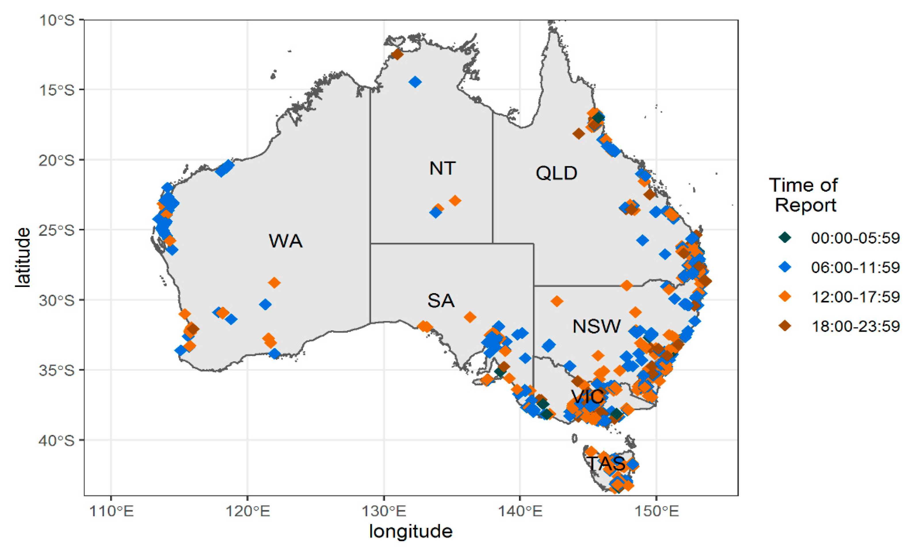
3.7. Roadkill Hotspots

Two transects of highways where roadkill was apparently high were selected for detailed examination: one in Queensland and the other in Tasmania. On the Queensland transect, the roadkill total (n = 38) on 600 km of road observed (20 km × approximately 30 days of monitoring by citizen scientists) was calculated to be a rate of 0.063 roadkill·km−1·day−1 (Figure 3).
The red circles represent one roadkill, the green dots represent between three and nine roadkill and the yellow dots represent upwards of ten roadkill.
On the Tasmanian transect, the roadkill total (n = 25) on approximately 360 km of road observed (6 km × approximately 60 days of monitoring by citizen scientists) was calculated to be at a rate of 0.069 roadkill·km−1·day−1 (Figure 4).
The red dots represent one roadkill and the green dots between two and nine roadkill.

4. Discussion

There are several ecological and human reasons for gathering data on Australian roadkill. ‘One Welfare’ is an emerging term. The concept refers to animal welfare, human welfare and environmental sustainability. It serves to highlight the interconnections between animal welfare, human wellbeing and the environment, and promotes direct and indirect links [39,40]. Roadkill can be placed in the concept of ‘One Welfare,’ as it affects humans, animals and the environment. The current project demonstrates the advantages and benefits of comprehensively, effectively and systematically monitoring Australian roadkill as a ‘One Welfare’ concept. The data obtained can be used to identify roadkill hotspots, raise the profile of roadkill in the mind of the public, identify the species killed and determine their distribution. This information can be entered into the database for future evaluation.
Engaging citizen scientists has highlighted the problems that roadkill presents in the mind of the general public through the publicity it has attracted. Evidence of this can be seen in the sudden increase in installations during September and reports at the beginning of November 2019 correlating with media exposure. As the project progresses, this public awareness is likely to increase. Community groups will be able to use the data from the RRApp to enhance research and general funding for mitigation measures and their implementation. The project has also shown how the time of monitoring by citizen scientists is dependent on the quadrant of day (QOD), i.e., mainly between 06:00 and 18:00. This would indicate that it might be advantageous to target members of those demographic groups, such as wildlife carers, so-called grey nomads (Australian retirees who travel within their own country for an extended time, usually in a caravan or motor home), local councils and environment networks who are travelling or working during this time (Q2 and Q3). The data gathered can also be used in ecological studies.
The data shown in Figure 2 are based on state boundaries, and this process draws in some minor idiosyncrasies. Specifically, it does not account for the small area in the southeast of Western Australia that borders South Australia that is on Australian Central Western Standard Time or the fact that Broken Hill (New South Wales) is on Adelaide time (Australian Central Standard Time).
Five areas of how monitoring roadkill can be used are explored in depth by Shilling and Perkins [41]. These areas are: monitoring wildlife roadkill numbers; species distributions; population trends and impacts; animal behaviour (specifically movement); and contaminants and disease. In the context of the current project, it has been shown how these five areas are pertinent to Australian ecology.
The current mapping outputs (Figure 3 and Figure 4) confirm that by citizen scientists monitoring wildlife roadkill numbers, transects where roadkill seems high can be identified as hotspots. Although the project is in its early stages, it has been possible to use some of the data to indicate important species distributions. One example is the reported distribution of cane toads (Rhinella marina, n = 4)—three reports of which were from Queensland and one of which was apparently from northern New South Wales—this latter report is at the limit of the known range of this introduced pest species. Future roadkill sightings could alert authorities to further spread of this species which has been predicted to stretch to the Australian west coast [42]. Should increasing global temperatures make habitat available to cane toads even further south than is currently predicted, it is important to use every method available, such as the simple and inexpensive RRApp, to detect this possible movement.
The current data indicate that over time, collated roadkill reports can highlight relative population trends. One example is that of the Tasmanian devil (Sarcophilus harrisii). Only a single roadkill was reported by RRApp users (Appendix C). This low number could reflect the ongoing impact of Devil Facial Tumour Disease (DFTD). This is an aggressive non-viral clonally transmissible cancer which affects Tasmanian devils which is associated with high mortality [43]. As DFTD has reduced the Tasmanian devil population, there has been a drop in Tasmanian devil roadkill numbers [6,44,45]. A higher reported number of roadkill devils in longitudinal data might indicate a species recovery, as other authors have used roadkill as an indicator of population size or density. For example, Baker et al. used road traffic casualties (roadkill) to monitor population changes in red foxes (Vulpes vulpes) [46], Canova and Balestrieri to monitor mammal species [47] and Gehrt to monitor raccoon abundance [48]. Similar data could be used to monitor feral cat numbers in Australia. The discovery of foxes (Vulpes vulpes) in Tasmania was triggered by a roadkill sighting, as happened in the early stages of the successful fox eradication programme in the island state [49,50,51]. In the re-introduction programme of the eastern quoll (Dasyurus viverrinus) to the mainland of Australia, many quolls became roadkill [52]. With over 2000 roadkill reports in three months from the RRApp, there exists an initial baseline against which longitudinal trends can be analysed in the future.
The current data hold some promise for revealing how species adapt their behaviour to the rapid environmental changes caused by bushfires, drought and flood [53,54]. Monitoring of roadkill can give an insight into behavioural changes, such as animal movement. In a country as large as Australia, RRApp data from citizens already on the move could provide a means to reveal behaviour changes that would otherwise be expensive and difficult to undertake.
Photographs of roadkill can also be used to monitor the incidence of disease in affected animals. Sarcoptic mange in wombats [55] and DFTD in Tasmanian devils [56,57], for example, can both be successfully detected using roadkill photographs. Such photographs, combined with their date- and time-stamped GPS can be used as sentinels to monitor wildlife disease. Sarcoptic mange is the biggest killer of wombats, and is reported to be present in 90% of common wombat populations. However, from examination of the photographs of reported roadkill wombats (n = 181), it was not possible to identify a single case of mange. This suggests that infected animals may not present on roadsides to feed and expose themselves to vehicles and become roadkill.
A further benefit of data from RRApp is the ability for Australia to join the other 12 countries undertaking roadkill reporting schemes and to submit data to the Global Biodiversity Information Facility (GBIF) (https://www.gbif.org/), a database that currently (March 2020) holds approximately 1.5 billion records and 49,050 individual datasets [41]. Australia is a voting participant on the GBIF. Publishing data from the RRApp, into the Atlas of Living Australia [58] the national node, should result in those data being published globally through the GBIF. The benefits of doing so are explored by Edwards [59], and include allowing users to search for georeferenced specimen and observational data, check for common and scientific names for organisms (including synonyms), plot maps showing the known localities of specimens in the system, and retrieve lists of taxa by country.
There are several limitations to using citizen scientists to gather roving reports and there is also concern regarding the rigor and usability of data collected by citizens who have not been formally trained in empirical science [60]. These merit detailed consideration. Recruitment and sustainability of volunteers can be a restraint on the quantity of data gathered. This is shown in this project by the reduction in reports logged per day over time, which infers a reduction in participants from the launch in September to November 2019. Media coverage was successful in driving initial uptake in Oct (n = 812), but usage dropped off considerably in November (n = 443). The number of reports seemed to be stabilizing, with approximately n = 380 in December 2019 and n = 368 in January 2020.
There was a drop off between the 2318 people who installed the RRApp between September 2019 and December 2019 and the 322 who produced a report. These data showed that approximately 10% of the users were responsible for approximately 50% of the reports. This indicates that there is a subset of users who are highly engaged with the app. In addition, potential reporters have to possess and operate a smartphone, iPad, tablet or similar device and to be able to download the RRApp. The population of Australia over the age of 14 years in 2020 is estimated at 20,500,000 [61]—of whom, 18,880,000 [62] have smartphones. However, despite 91% of the Australian population over the age of 14 owning smartphones, rates of engagement with the app remain an issue.
Another constraint on gathering data is that the time of day that the recording takes place is at the discretion of the user. Citizen scientists do not actively report the absence of roadkill and they may travel along a transect and take no photograph. This may skew results, as it is not possible to know the frequency with which any given transect is monitored. Thus, only an approximate calculation can be made of the roadkill rate per kilometre per week. The inability to calculate effort put in by each observer remains problematic for most citizen science projects, although the literature does suggest a number of ways that this can be addressed [63,64,65]. The data in Figure 1 indicate that most reports were made between 06:00 and 18:00 (Q2 and Q3). Mammal reports appear to account for a higher percentage of midnight to midday reports whereas bird reports appear disproportionately high between midday and midnight. “Other” reports (reptilian) appear most common in the afternoon and evening. The significance of these findings is that they align with the reality that most of Australian mammals killed on the roads are crepuscular or nocturnal feeders [2,6]. This means that the most advantageous time to record mammalian roadkill is after dawn and before carcasses are dispersed by scavengers or anthropogenic means. In contrast, avian and reptilian roadkill tend to be active day feeders and reptiles that use the warming tarmac of roads to thermo-regulate before hunting, so most are likely to be killed between dawn and dusk. Thus, the most advantageous time to monitor avian and reptilian roadkill is before dusk.
Another consideration is the in situ persistence of roadkill. The lower the mass of individual roadkill, the shorter the time it persists in the environment [66]. Therefore, avian and reptilian roadkill need to be recorded as soon as possible after death, i.e., evening time. In controlled studies of roadkill among targeted species, the observation and recording time would be chosen to suit the species being monitored; a provision unlikely to be available for citizen science projects in which volunteers are likely to monitor at a time suited to themselves. In the current project, most reports were taken in Q2 and Q3. Although the highest number of avian and reptilian roadkill reports occurred in Q4, the evening (Table 1), the overall percentage of avian and reptilian roadkill relative to mammalian roadkill was 14.75% to 85.25%, respectively.
A further limitation of citizen science could be the possible need to train the citizen scientists. However, the RRApp requires virtually no training to use it, so it is extremely efficient in use of respondents’ time. However, it does require experts to donate their time for identification of animals but many organisations such as iNaturalist, the Australian and State museums as well as the National Parks and Wildlife service offer complimentary species identification services. These services could be utilised to make the ARRP sustainable.
It is also worth acknowledging that the current data may include some observer bias. People are more likely to see larger roadkill than smaller, and may be more interested in mammals than reptiles/birds. The local speed limit of the road might also have an impact on ability to observe, pull over and record. The use of the RRApp whilst driving a vehicle would render the user liable to prosecution. So, a solo driver is unable to use the RRApp unless they are able to stop the vehicle in a safe place. This adds to one’s journey time, so may discourage the driver from recording data. Clearly, if the vehicle carries on moving, a passenger must operate the RRApp. This presents a further limitation because the resultant photographs would be taken from some distance and could be blurred, which in turn makes identification of roadkill at a species level unreliable. Similarly, depending upon the speed of a vehicle, smaller animals may go unseen and unrecorded.
There are important differences in potential reporters’ opportunity to pull over and record data. Some roads have no safe shoulder on which to pull over. It may be that roads with high speed limits [67], that are winding or uneven, are more likely to have high roadkill but are also more difficult for citizen scientists to pull over in a safe and timely fashion after spotting roadkill, so compromising the representativeness of data collection. However, data that are collected can be used to produce a general map that may help identify a possible roadkill hotspot transect. The data recorded are the minimum roadkill that occurred so produce a conservative estimate of roadkill. Nevertheless, some hotspots will inevitably be missed through lack of data. For the two hotspots analysed here, from Queensland and Tasmania (Figure 3 and Figure 4), even the conservative results show a significantly higher rate of roadkill·km−1·day−1, at 0.063 and 0.069, respectively, than the average roadkill recorded in other science-based projects such as 0.031 [68], 0.035 [1] and 0.042 [6]. However, these other studies revealed marked temporal and spatially differences in topography and road conditions and were not focussed on identifying hotspots. Thus, it is reasonable to conclude that the two transects discussed in Queensland and Tasmania can reliably be defined as roadkill hotspots.
Another limitation is the possibility of double counts of roadkill but, by using an algorithm to identify proximate GPS locations and viewing individual photographs contained in the RRApp recorded on the website, this problem was mitigated during analysis and duplicates (n = 6) were discarded. However, there is a positive aspect to duplicates in that they could be used to estimate persistence of roadkill and duplicates may present an image that improves the potential for animal identification.
As indicated above, there are several possible avenues for future research. Once analysis of the RRApp reports has identified a cluster on a transect as a roadkill hotspot, it needs to be followed up by detailed research. Ideally, this should be supervised by professional researchers so that observer effort is standardised. Other areas that could be investigated, but would also require professional supervision on the use of the RRApp, include estimated latency between the roadkill event and the report, the relationships among day of the week, vehicle density and speed and roadkill [6,35,67,69]; the effectiveness of existing mitigation strategies (such as roadside fencing, wildlife bridges/crossings and culverts) [70,71,72]; and the role of normal species behaviour [73,74] (such as daily foraging/hunting, mating/nesting season and migration).
Several possible refinements to the RRApp merit consideration. When recruiting users of the RRApp, the current project targeted the general population through television, newsprint and social media. The problem of volunteer recruitment and retention of citizen scientists has been addressed in several studies [75,76,77,78,79]. Bil et al. [80] suggest that volunteers need to be motivated by the organisers to participate on a long-term basis and be provided with regular feedback on how their data are being used to produce new scientific knowledge. They also suggest that the target group for recruitment are road users who have an interest in animal welfare, nature conservation or road safety and have access to the internet and a smartphone. This group could include environmentalists, hunters and shooters, local council road maintenance crews, police, drivers, commuters, grey nomads, wildlife carer groups, students and walkers. To reach the different groups that Bil et al. [80] suggested, it may prove necessary to recruit a broader cohort of citizen scientists. This could be achieved through editorial and talking point items in magazines as well as television and radio items and newspaper feature magazines. In addition, a comprehensive dedicated website that disseminates information gained may retain recruits and engage them, perhaps with feedback on reports received. There is also a need to engage a principal organisational entity such as a university, museum, or non-government organisation to take over the running of the ARRP. The danger of leaving it to one private individual to oversee could result in the rapid demise of the project that underpins the RRApp. One strategy to be explored would be to secure funding to build a team of professionals similar to that of the ebird project (n = 25) [19].

5. Conclusions

The ARRP collects substantial roadkill data that contribute to knowledge across a diversity of research needs. The current RRApp data report on roadkill in mammals (n = 1203, 75%), birds (n = 125, 7.8%) reptiles (n = 79, 4.9%) amphibians (n = 4, 0.025%) and unidentified (n = 189, 11.8%). A significant finding is variance in the distribution of mammals and birds at different times of day (p < 0.001). This paper also reveals how clusters of roadkill are identified in Queensland and Tasmania and how the presence of invasive species such as the cane toad, red fox and feral cat can be demonstrated through roadkill sightings. To reveal longitudinal trends, recruitment of citizen scientists and their retention over several years are required. Together, these can provide valuable data that could be used to instigate cost-effective roadkill mitigation measures, track animal behaviour and disease, monitor animal re-introduction programmes and the dispersal of feral species.

Author Contributions

Conceptualization, B.E. and P.M.; methodology, B.E.; software, B.E.; formal analysis, B.E., B.W., and C.R.; investigation, B.E.; resources, B.E.; data curation, B.E., B.W., and C.R.; writing—original draft preparation, B.E.; writing—review and editing, B.E., P.M., M.S., B.W., and C.R.; visualization, B.E., P.M., and M.S.; supervision, B.E.; project administration, B.E. All authors have read and agreed to the published version of the manuscript.

Funding

This research received no external funding.

Acknowledgments

We appreciate the contribution of the following people or group: for assistance in evaluating the RRApp prototype, Steve Candy, Maureen Englefield, Kevin Englefield, Sandra Johnson, Daniel Johnson, Steven Johnson, Nick Mooney, Simone Bingham, Barry Legg, Maureen Legg, Alan Clark, Tim Leaman and Josie Styles; The Bruny Island Environment Network for collection and supply of reports; Elleke Leurs, for feedback after using the RRApp; the Honourable Sussan Ley, Minister for the Environment, Senators Eric Abetz and Clare Chandler for launching the RRApp to the media; the legal department of the Sydney University Postgraduate Representative Association for producing the disclaimers for the RRApp; experts from the Queensland museum, Victoria museum, Australia museum and individual experts, Ian Norton and Nick Mooney for assistance in animal identification; Martin Anderson of Ionata Digital for continued assistance and supply of information following development of the RRApp.

Conflicts of Interest

The authors declare no conflict of interest.

Appendix A. Human Research Ethics Exemption Certificate

Roadkill Reporter Exemption certificate
Research Integrity & Ethics Administration
Human Research Ethics Committee
Wednesday, 9 October 2019
Mr Bruce Englefield
Veterinary Science
The University of Sydney
Dear Bruce,
Project Title: Roadkill Reporter App
The NHMRC National Statement on Ethical Conduct in Human Research (“The National Statement”) outlines circumstances where research that carries only negligible risk may be exempted from ethical review.
The National Statement defines negligible risk as follows:
“The expression ‘negligible risk research’ describes research in which there is no foreseeable risk of harm or discomfort; and any foreseeable risk is no more than inconvenience.” (National Statement 2.1.7)
Further, the National Statement states that institutions may choose to exempt research from ethical review which meets the following criteria:
(a)
“is negligible risk research (as defined in paragraph 2.1.7); and
(b)
involves the use of existing collections of data or records that contain only non-identifiable data about human beings.” (National Statement 5.1.22).
Based on what you have described in communication with the Ethics Office, your project is negligible risk and will utilise a dataset from the Roadkill Reporter App that does not contain any identifiable information about human beings. Therefore, your project can be exempt from ethics review.
Should any future work not comply with any of the above, the project must be submitted for ethical review prior to commencing research. Please note that retrospective ethical approval of research cannot be given by the HREC.
Please contact the Ethics Office should you require further information or clarification.
Sincerely,
Animals 10 01112 i001
Karyn Ridgway
Human Ethics Officer
Research Integrity & Ethics Administration
Research Portfolio
Level 3, F23 Administration Building
The University of Sydney
NSW 2006 Australia

Appendix B

Table B1. Standard deviation, Easting and Northing difference correlation co-efficient for comparisons (n = 10) of accuracy of RRApp taken by SMGPS app and the RRApp.
LocationShare My
GPS_SEasting
Share My
GPS_SNorthing
RRApp
_SEasting
RRApp
_SNorthing
Distance between Locations in Metres
1520808.0227−4757145.856520806.3719−4757146.9841.999
2520467.1664−4757095.557520465.2106−4757097.7952.972
3516754.7728−4758660.936516756.1234−4758658.7622.559
4516696.15−4758687.444516694.418−4758688.852.231
5517173.7803−4758644.561517175.3993−4758639.4565.355
6517075.1475−4758647.801517075.6634−4758646.8921.045
7518128.9989−4758205.725518130.5364−4758204.0192.297
8520345.0792−4757104.233520350.832−4757103.1185.860
9520483.7514−4757074.752520484.4861−4757074.4990.777
10520777.6065−4757136.758520777.2204−4757137.6891.008
Easting Correlation Coef.: 0.999999231; Northing Correlation Coef.: 0.999997278; STD DEV: 1.739
LocationEasting—Easting
Point 1
Northing—Northing
Point 1
RRapp_Easting—Easting
Point 1
RRappNorthing—Northing
Point 1
100−1.650797029−1.127687
2−340.85628850.29840563−342.812101648.06106037
3−4053.249922−1515.079764−4051.899284−1512.906514
4−4111.872771−1541.588346−4113.604726−1542.994444
5−3634.242451−1498.704672−3632.623418−1493.600491
6−3732.875241−1501.945109−3732.359305−1501.035796
7−2679.023828−1059.868798−2677.486356−1058.162716
8−462.943530441.62243735−457.190687242.73805936
9−324.271333971.10381988−323.536591371.35703658
10−30.416232549.09830529−30.802356568.16666604
Easting difference Correlation Coefficient: 0.9999992; Northing difference Correlation Coefficient: 0.9933340

Appendix C. Roadkill Photograph Report

Table C1. Animal roadkill recorded by the RRApp categorised by group and species.
SpeciesOct.Nov.Dec.Total
Amphibians4004
eastern sedge frog (Litoria fallax)1001
spotted marsh frog, (Limnodynastes tasmaniensis)1001
marbled marsh frog (Limnodynastes convexiusculus)1001
stony creek frog (Litoria wilcoxi)1001
Diurnal Birds652916111
black-faced wood swallow (Artamus cinereus normani)0202
black-shouldered kite (Elanus axillaris)0101
blue-billed duck (Oxyura australis)0101
brush cookoo (Cacomantis variolosus)1001
brush turkey (Alectura lathami)112215
butcherbird (Cracticus)0011
carrawong (Strepera)1001
crimson rosella (Platycercus elegans)1102
dusky moorhen (Gallinula tenebrosa)1012
eastern spinebill (Acanthorhynchus tenuirostris)1001
emu (Dromaius novaehollandiae)2002
figbird (Sphecotheres)1001
forest raven (Corvus tasmanicus)112316
galah (Eolophus roseicapilla)5005
green rosella (Platycercus caledonicus)0101
kookaburra (Dacelo)2248
little bronze-cuckoo (Chrysococcyx minutillus)1001
little wattlebird (Anthochaera chrysoptera)1001
magpie (Gymnorhina tibicen)77014
masked lapwing (Vanellus miles)0224
noisy friarbird (Philemon corniculatus)1001
noisy miner (Manorina melanocephala)4105
pied carrawong (Strepera graculina)6006
rainbow lorikeet (Trichoglossus haematodus)1001
silvereye (Zosterops lateralis)1001
spotted pardalote (Pardalotus punctatus)1001
sulphur crested cockatoo (Cacatua galerita)1012
Tasmanian native hen (Tribonyx mortierii)1102
wedge-tailed eagle (Aquila audax)1102
whistling kite (Haliastur sphenurus)0101
wood duck (Chenonetta jubata)1214
white ibis (Threskiornis molucca)1001
yellow-tailed black cockatoo (Calyptorhynchus funereus)0213
Exotic Species155524
boar pig (Sus scrofa domesticus)1001
cane toad (Rhinella marina)2114
cat (Felis catus)2013
cow (Bos Taurus)2002
deer (Cervidae)0011
goat (Capra hircus)0101
hare (Lepus)3216
rabbit (Leporidae)2013
red fox (Vulpes vulpes)1001
spotted turtle dove (Spilopelia chinensis)0101
call duck (Anas platyrhynchos)1001
Mammal—Macropod412260232904
agile wallaby (Macropus agilis)19151650
bandicoot (Perameles)162321
Bennet’s wallaby (Macropus rufogriseus)56920
bettong (Bettongia)3003
eastern grey kangaroo (Macropus giganteus)18110789377
long nose potoroo (Potorous tridactylus)0011
Lumholtz’s tree kangaroo (Dendrolagus lumholtzi)1001
pademelon (Thylogale)20171350
parma wallaby (Macropus parma)0011
potoroo (Potorous)3104
pretty-faced wallaby (Macropus parryi)1001
red kangaroo (Macropus rufus)139426
red necked wallaby (Macropus rufogriseus)593015104
red-legged pademelon (Thylogale stigmatica)0213
rufous bettong (Aepyprymnus rufescens)1326
spectacled hare-wallaby (Lagorchestes conspicillatus)0101
swamp wallaby (Wallabia bicolor)513346130
wallaroo (Macropus robustus)24223177
western grey kangaroo (Macropus fuliginosus)83112
whiptail wallaby (Macropus parryi)79016
Mammal—Other1666946281
brushtail possum (Trichosurus vulpecula)369449
eastern quoll (Dasyurus viverrinus)0022
echidna (Tachyglossidae)65213
flying fox bat (Pteropus)5128
koala (Phascolarctos cinereus)84517
ringtail possum (Pseudocheirus peregrinus)4239
Tasmanian devil (Sarcophilus harrisii)0011
white-tailed rat (Uromys caudimaculatus)0011
Wombat (Vombatidae)1084825181
Nocturnal Birds63312
bush stone-curlew (Burhinus grallarius)0112
cassowary (Casuarius)1001
eastern barn owl (Tyto alba)2103
Papuan frogmouth (Podargus papuensis)0011
southern boobook owl (Ninox novaeseelandiae)1001
tawny frogmouth (Podargus strigoides)2114
Reptiles52161179
bandy bandy snake (Vermicella annulate)2114
blotched blue-tongue lizard (Tiliqua nigrolutea)74314
bob tail lizard (Tiliqua rugosa)0202
broad headed snake (Hoplocephalus bungaroides)0101
brown tree snake (Boiga irregularis)1001
carpet python (Morelia spilota)4004
common tree snake (Dendrelaphis punctulate)1102
eastern bearded dragon (Pogona barbata)1001
eastern brown snake (Pseudonaja textilis)131216
eastern water dragon (Intellagama lesueurii)2013
goanna (Varanus)1001
keelback snake (Tropidonophis mairii)1001
lace monitor lizard (Varanus varius)64111
nobbi dragon lizard (Diporiphora nobbi) 1001
red-bellied black snake (Pseudechis porphyriacus)6219
shingleback lizard (Tiliqua rugosa)2002
stumped-tailed lizard (Tiliqua rugosa)2002
tiger snake (Notechis scutatus)1012
western brown snake (Pseudonaja nuchalis)0011
yellow spotted monitor (Varanus panoptes)1001

References

  1. Klöcker, U.; Croft, D.B.; Ramp, D. Frequency and causes of kangaroovehicle collisions on an Australian outback highway. Wildl. Res. 2006, 33, 5–15. [Google Scholar] [CrossRef]
  2. Ramp, D.; Caldwell, J.; Edwards, K.A.; Warton, D.; Croft, D.B. Modelling of Wildl. fatality hotspots along the Snowy Mountain Highway in New South Wales, Australia. Biol. Conserv. 2005, 126, 474–490. [Google Scholar] [CrossRef]
  3. Ramp, D. In Sharing the environment: Counting the cost of wildlife mortality on roads, National Wildlife Carers Conference, 2004. Available online: https://www.awrc.org.au/uploads/5/8/6/6/5866843/nwcc-ramp-s-040726.pdf (accessed on 26 June 2020).
  4. Taylor, B.D.; Goldingay, R.L. Wildlife road-kills on three major roads in north-eastern New South Wales. Wildl. Res. 2004, 31, 83–91. [Google Scholar] [CrossRef]
  5. Vestjens, W.J.M. Wildlife mortality on a road in New South Wales. Emu 1973, 73, 107–112. [Google Scholar] [CrossRef]
  6. Hobday, A.J.; Minstrell, M.L. Distribution and abundance of roadkill on Tasmanian highways: Human management options. Wildl. Res. 2008, 35, 712–726. [Google Scholar] [CrossRef]
  7. Coulson, G. Road-kills of macropds on a section of highway in central Victoria. Wildl. Res. 1982, 9, 21–26. [Google Scholar] [CrossRef]
  8. Leeuwenburg, P. Roadkill on Kangaroo Island: Identification of Patterns and Predictors of Roadkill. Bachelor’s Thesis, University of South Australia, Adelaide, Australia, 2004. [Google Scholar]
  9. Bonney, R. Citizen science: A lab tradition. Living Bird 1996, 15, 7–15. [Google Scholar]
  10. Irwin, A. Citizen Science a Study of People, Expertise, and Sustainable Development; Routledge: London, UK, 1995. [Google Scholar]
  11. Kallimanis, A.; Panitsa, M.; Dimopoulos, P. Quality of non-expert citizen science data collected for habitat type conservation status assessment in Natura 2000 protected areas. Sci. Rep. 2017, 7, 8873. [Google Scholar] [CrossRef] [Green Version]
  12. Tiago, P.; Ceia-Hasse, A.; Marques, T.; Capinha, C.; Pereira, H. Spatial distribution of citizen science casuistic observations for different taxonomic groups. Sci. Rep. 2017, 7, 12832. [Google Scholar] [CrossRef] [PubMed] [Green Version]
  13. Diemer, V.; Marc, H. Citizen science and smartphones take roadkill monitoring to the next level. Nat. Conserv. 2015, 11, 29–40. [Google Scholar]
  14. SciStarter. Science We Can Do Together. Available online: www.scistarter.org (accessed on 22 November 2019).
  15. Bautista-Puig, N.; De Filippo, D.; Mauleón, E.; Sanz-Casado, E. Scientific Landscape of Citizen Science Publications: Dynamics, Content and Presence in Social Media. Publications 2019, 7, 12. [Google Scholar] [CrossRef] [Green Version]
  16. Lukyanenko, R.; Wiggins, A.; Rosser, H. Citizen Science: An Information Quality Research Frontier. Inf. Syst. Front. 2019, 1–23. [Google Scholar] [CrossRef] [Green Version]
  17. McGreevy, P.; Starling, M.; Payne, E.; Bennett, P. Defining and measuring dogmanship: A new multidisciplinary science to improve understanding of human—Dog interactions. Vet. J. 2017, 229, 1–5. [Google Scholar] [CrossRef] [PubMed]
  18. BirdlifeAustralia Birdata. Available online: https://birdata.birdlife.org.au/ (accessed on 27 January 2020).
  19. Cornell University eBird. Available online: https://ebird.org/home (accessed on 3 June 2020).
  20. Perkins, S. Project Splatter Cardiff University. Available online: https://projectsplatter.co.uk/ (accessed on 24 June 2020).
  21. PTES New App Turns Roadkill Into British Wildlife Protection. Available online: https://ptes.org/new-app-turns-roadkill-british-wildlife-protection/ (accessed on 3 February 2020).
  22. Milind, P. Roadkills a Citizen Science Initiative. Available online: https://www.conservationindia.org/articles/roadkills-a-citizen-science-initiative (accessed on 4 February 2020).
  23. Masa, A.N.O.M.Y.T. Roadkill Observation Network. Available online: https://www.facebook.com/groups/stoptheroadkill/about/ (accessed on 5 March 2020).
  24. Naturpunt Animals under wheels. Available online: https://www.natuurpunt.be/pagina/dieren-onder-de-wielen (accessed on 5 March 2020).
  25. Bíl, M.; Kubeček, J.; Sedoník, J.; Andrášik, R. Srazenazver.cz: A system for evidence of animal-vehicle collisions along transportation networks. Biol. Conserv. 2017, 213, 167–174. [Google Scholar] [CrossRef]
  26. Heigl Project Roadkill. Available online: https://ecsa.citizen-science.net/working-groups/citizen-science-and-open-science/project-roadkill-citizen-science-based-open-data (accessed on 5 March 2020).
  27. Olson, D.D.; Bissonette, J.A.; Cramer, P.C.; Green, A.D.; Davis, S.T.; Jackson, P.J.; Coster, D.C. Monitoring Wildlife-Vehicle Collisions in the Information Age: How Smartphones Can Improve Data Collection. (Research Article). PLoS ONE 2014, 9, e98613. [Google Scholar] [CrossRef] [Green Version]
  28. Silvertown, J. A new dawn for citizen science. Trends Ecol. Evol. 2009, 24, 467–471. [Google Scholar] [CrossRef] [PubMed]
  29. Conrad, C.; Hilchey, K. A review of citizen science and community-based environmental monitoring: Issues and opportunities. Environ. Monit. Assess. 2011, 176, 273–291. [Google Scholar] [CrossRef]
  30. Shilling, F.M.; Waetjen, D.P. Wildlife-vehicle collision hotspots at US highway extents: Scale and data source effects. Nat. Conserv. 2015, 11, 41. [Google Scholar] [CrossRef] [Green Version]
  31. Adams, Y. Citizen Science and Road Ecology. Available online: https://discovermammals.org/citizen-science-and-road-ecology/ (accessed on 5 March 2020).
  32. Morantes Hernández, P.J. Characterisation of Initiatives to Reduce the Death of Fauna on Roads in Carretera Columbia. 2015. Available online: https://scholar.google.com/scholar?hl=en&as_sdt=0%2C5&q=Morantes+Hern%C3%A1ndez%2C+Pilar+Juliana&btnG= (accessed on 26 June 2020).
  33. Kioko, J.; Kiffner, C.; Jenkins, N.; Collinson, W.J. Wildlife roadkill patterns on a major highway in northern Tanzania. Afr. Zool. 2015, 50, 17–22. [Google Scholar] [CrossRef]
  34. Englefield, B.; Candy, S.G.; Starling, M.; McGreevy, P.D. A Trial of a Solar-Powered, Cooperative Sensor/Actuator, Opto-Acoustical, Virtual Road-Fence to Mitigate Roadkill in Tasmania, Australia. Animal 2019, 9, 752. [Google Scholar] [CrossRef] [Green Version]
  35. Fox, J.; Friendly, M.; Weisberg, S. Hypothesis Tests for Multivariate Linear Models Using the car Package. R J. 2013, 5, 39. [Google Scholar] [CrossRef] [Green Version]
  36. Long, J.A. jtools: Analysis and Presentation of Social Scientific Data. R Package Version 2.0.1. 2019. Available online: https://rdrr.io/cran/jtools/ (accessed on 5 March 2020).
  37. Lenth, R. Estimated Marginal Means. Available online: https://github.com/rvlenth/emmeans (accessed on 8 April 2020).
  38. Australian Bureau of Statistics. Australian Standard Geographical Classification (ASGC) Digital Boundaries; Australian Bureau of Statistics: Canberra, Australia, 2011. [Google Scholar]
  39. Pinillos, R.G.; Appleby, M.C.; Manteca, X.; Scott-Park, F.; Smith, C.; Velarde, A. One Welfare—A platform for improving human and animal welfare. Vet. Rec. 2016, 179, 412. [Google Scholar] [CrossRef] [PubMed] [Green Version]
  40. Colonius, T.J.; Earley, R.W. One welfare: A call to develop a broader framework of thought and action. J. Am. Vet. Med. Assoc. 2013, 242, 309–310. [Google Scholar] [CrossRef] [PubMed]
  41. Shilling, F.; Perkins, S. The value of monitoring wildlife roadkill. Eur. J. Wildl. Res. 2020, 66, 18. [Google Scholar]
  42. Poole, C. Cane Toad Distribution in Australia. Available online: https://poole77.files.wordpress.com/2012/10/cane-toad-distribution-in-australia.jpg?w=683 (accessed on 25 March 2020).
  43. Hawkins, C.E.; Baars, C.; Hesterman, H.; Hocking, G.J.; Jones, M.E.; Lazenby, B.; Mann, D.; Mooney, N.; Pemberton, D.; Pyecroft, S.; et al. Emerging disease and population decline of an island endemic, the Tasmanian devil Sarcophilus harrisii. Biol. Conserv. 2006, 131, 307–324. [Google Scholar] [CrossRef]
  44. Lazenby, B.T.; Tobler, M.W.; Brown, W.E.; Hawkins, C.E.; Hocking, G.J.; Hume, F.; Huxtable, S.; Iles, P.; Jones, M.E.; Lawrence, C.; et al. Density trends and demographic signals uncover the long-term impact of transmissible cancer in Tasmanian devils. J. Appl. Ecol. 2018, 55, 1368–1379. [Google Scholar] [CrossRef]
  45. Jones, M.E. Road upgrade, road mortality and remedial measures: Impacts on a population of eastern quolls and Tasmanian devils. Wildl. Res. 2000, 27, 289–296. [Google Scholar] [CrossRef]
  46. Baker, P.J.; Harris, S.; Robertson, C.P.J.; Saunders, G.; White, P.C.L. Is it possible to monitor mammal population changes from counts of road traffic casualties? An analysis using Bristol’s red foxes Vulpes vulpes as an example. Mammal. Rev. 2004, 34, 115–130. [Google Scholar] [CrossRef]
  47. Canova, L.; Balestrieri, A. Long-term monitoring by roadkill counts of mammal populations living in intensively cultivated landscapes. Biodivers. Conserv. 2019, 28, 97–113. [Google Scholar] [CrossRef]
  48. Gehrt, S. Evaluation of spotlight and road-kill surveys as indicators of local raccoon abundance. Wildl. Soc. Bull. 2002, 30, 449–456. [Google Scholar]
  49. Berry, O.; Sarre, S.; Farrington, L.; Aitken, N. Faecal DNA detection of invasive species: The case of feral foxes in Tasmania. Wildl. Res. 2007, 34, 1–7. [Google Scholar] [CrossRef]
  50. Caley, P.; Ramsey, D.S.L.; Barry, S.C. Inferring the distribution and demography of an invasive species from sighting data: The red fox incursion into Tasmania. PLoS ONE 2015, 10, e0116631. [Google Scholar] [CrossRef]
  51. Sydney Morning Herald. Fox alert in Tasmania. Available online: https://www.smh.com.au/national/fox-alert-in-tasmania-20040520-gdiyjf.html (accessed on 7 June 2020).
  52. Lagan, B. Cat Marsupials Born in Wild After 50 Years (News). Available online: https://www.smithsonianmag.com/smart-news/endangered-eastern-quolls-are-born-mainland-australia-first-time-50-years-180969578/ (accessed on 20 April 2020).
  53. Parmesan, C.; Root, T.; Willig, M. Impacts of extreme weather and climate on terrestrial biota. Bull. Am. Meteorol. Soc. BostonMa 2000, 81, 443–450. [Google Scholar] [CrossRef] [Green Version]
  54. Pecl, G.T.; Araújo, M.B.; Bell, J.D.; Blanchard, J.; Bonebrake, T.C.; Chen, I.C.; Clark, T.D.; Colwell, R.K.; Danielsen, F.; Evengård, B.; et al. Biodiversity redistribution under climate change: Impacts on ecosystems and human well-being. Science (N. Y.) 2017, 355, aai9214. [Google Scholar] [CrossRef] [PubMed]
  55. Harris, J. Photograps of Roadkill Wombats with Mange. Available online: https://www.bing.com/images/search?q=john+harris+roadkill+wombats&qpvt=john+harris+roadkill+wombats&form=IGRE&first=1&cw=1117&ch=476 (accessed on 2 June 2020).
  56. Kwon, Y.M.; Stammnitz, M.R.; Wang, J.; Swift, K.; Knowles, G.W.; Pye, R.J.; Kreiss, A.; Peck, S.; Fox, S.; Pemberton, D.; et al. Tasman-PCR: A genetic diagnostic assay for Tasmanian devil facial tumour diseases. R Soc. Open Sci 2018, 5, 180870. [Google Scholar] [CrossRef] [PubMed] [Green Version]
  57. TasmanianGovernment Report a Roadkill Sighting. Available online: https://dpipwe.tas.gov.au/wildlife-management/save-the-tasmanian-devil-program/about-the-program/roadkill-project/roadkill-tas-app (accessed on 2 June 2020).
  58. Day, D. Atlas of Living Australia. Available online: https://www.ala.org.au/ (accessed on 20 April 2020).
  59. Edwards, J.L. Research and Societal Benefits of the Global Biodiversity Information Facility. BioScience 2004, 54, 485–486. [Google Scholar] [CrossRef]
  60. Garbarino, J.; Mason, C.E. The Power of Engaging Citizen Scientists for Scientific Progress. J. Microbiol. Biol. Educ. 2016, 17, 7–12. [Google Scholar] [CrossRef] [Green Version]
  61. Worldometer Australian Population (live). Available online: https://www.worldometers.info/world-population/australia-population/ (accessed on 30 January 2020).
  62. Statistica. Number of Smartphone Users in Australia. Available online: https://www.statista.com/statistics/467753/forecast-of-smartphone-users-in-australia/ (accessed on 30 January 2020).
  63. Martin, V.Y.; Christidis, L.; Pecl, G.T. Public Interest in Marine Citizen Science. Is there Potential for Growth? BioScience 2016, 66, 683–692. [Google Scholar] [CrossRef]
  64. Martin, V.; Christidis, L.; Lloyd, D.; Pecl, G. Understanding drivers, barriers and information sources for public participation in marine citizen science. J. Sci. Commun. 2016, 15. [Google Scholar] [CrossRef] [Green Version]
  65. Martin, V.; Smith, L.; Bowling, A.; Christidis, L.; Lloyd, D.; Pecl, G. Citizens as Scientists: What Influences Public Contributions to Marine Research? Sci. Commun. 2016, 38, 495–522. [Google Scholar] [CrossRef]
  66. Santos, R.A.L.; Santos, S.M.; Santos-Reis, M.; Picanco de Figueiredo, A.; Bager, A.; Aguiar, L.M.S.; Ascensao, F. Carcass Persistence and Detectability: Reducing the Uncertainty Surrounding Wildlife-Vehicle Collision Surveys.(Research Article). PLoS ONE 2016, 11, e0165608. [Google Scholar] [CrossRef] [PubMed]
  67. Hobday, A.J. Nighttime driver detection distances for Tasmanian fauna: Informing speed limits to reduce roadkill. Wildl. Res. 2010, 37, 265. [Google Scholar] [CrossRef]
  68. Ramp, D.; Ben-Ami, D. The Effect of Road-Based Fatalities on the Viability of a Peri-Urban Swamp Wallaby Population. J. Wildl. Manag. 2006, 70, 1615–1624. [Google Scholar] [CrossRef]
  69. Ramp, D.; Wilson, K.V.; Croft, B.D. Contradiction and Complacency Shape Attitudes towards the Toll of Roads on Wildlife. Animals 2016, 6, 40. [Google Scholar] [CrossRef] [PubMed] [Green Version]
  70. Marcel, P.H.; John, W.D.; Anthony, P.C.; Robert, J.A.; Pat, T.M. Cost-Benefit Analyses of Mitigation Measures Aimed at Reducing Collisions with Large Ungulates in the United States and Canada: A Decision Support Tool. Ecol. Soc. 2009, 14, 15. [Google Scholar]
  71. Van Der Ree, R.; Smith, D.J.; Grilo, C. Handbook of Road Ecology; Wiley-Blackwell: Hoboken, NJ, USA, 2015. [Google Scholar]
  72. van Der Grift, E.; van Der Ree, R.; Fahrig, L.; Findlay, S.; Houlahan, J.; Jaeger, J.; Klar, N.; Madriñan, L.; Olson, L. Evaluating the effectiveness of road mitigation measures. Biodivers. Conserv. 2013, 22, 425–448. [Google Scholar] [CrossRef] [Green Version]
  73. Hughey, L.F.; Hein, A.M.; Strandburg-Peshkin, A.; Jensen, F.H. Challenges and solutions for studying collective animal behaviour in the wild. Philos. Trans. R. Soc. Lond. Ser. B Biol. Sci. 2018, 373, 20170005. [Google Scholar] [CrossRef] [Green Version]
  74. Jewell, Z. Effect of Monitoring Technique on Quality of Conservation Science. Conserv. Biol. 2013, 27, 501–508. [Google Scholar] [CrossRef]
  75. Beirne, C.; Lambin, X. Understanding the Determinants of Volunteer Retention Through Capture—Recapture Analysis: Answering Social Science Questions Using a Wildlife Ecology Toolkit. Conserv. Lett. 2013, 6, 391–401. [Google Scholar] [CrossRef]
  76. Frensley, T.; Crall, A.; Stern, M.; Jordan, R.; Gray, S.; Prysby, M.; Newman, G.; Hmelo-Silver, C.; Mellor, D.; Huang, J. Bridging the Benefits of Online and Community Supported Citizen Science: A Case Study on Motivation and Retention with Conservation-Oriented Volunteers.(Research paper)(Case study). Citiz. Sci. Theory Pract. 2017, 2, 4. [Google Scholar] [CrossRef] [Green Version]
  77. Bhattacharjee, Y. Citizen scientists supplement work of Cornell researchers: A half-century of interaction with bird watchers has evolved into a robust and growing collaboration between volunteers and a leading ornithology lab. (Ornithology). Science 2005, 308, 1402. [Google Scholar] [CrossRef] [PubMed]
  78. Wald, D.M.; Longo, J.; Dobell, A.R. Design principles for engaging and retaining virtual citizen scientists. Conserv. Biol. 2016, 30, 562–570. [Google Scholar] [CrossRef]
  79. Andow, D.; Borgida, E.; Hurley, T.; Williams, A. Recruitment and Retention of Volunteers in a Citizen Science Network to Detect Invasive Species on Private Lands. Environ. Manag. 2016, 58, 606–618. [Google Scholar] [CrossRef] [PubMed]
  80. Bíl, M.; Heigl, F.; Janoška, Z.; Vercayie, D.; Perkins, S.E. Benefits and challenges of collaborating with volunteers: Examples from National Wildlife Roadkill Reporting Systems in Europe. J. Nat. Conserv. 2020, 54, 125798. [Google Scholar] [CrossRef]
Figure 1. Distribution of roadkill reports by time of day, divided into four quadrants of day.
Animals 10 01112 g001
Figure 2. Location of roadkill reports by the quadrant of day (QOD), superimposed on a map of Australia. WA—Western Australia, NT—Northern Territory, SA—South Australia, QLD-Queensland, NSW—New South Wales, VIC—Victoria, and TAS—Tasmania.
Animals 10 01112 g002
Figure 3. Roadkill hotspot on 20 km of highway between Mount Larcom and east towards Mount Stowe State Forest, Queensland.
Animals 10 01112 g003
Figure 4. Roadkill hotspot on 6 km of highway between Alona on the west side and Adventure Bay on the east side of Bruny Island Tasmania.
Animals 10 01112 g004
Table 1. Total number of reports by state between 24/9/2019 and 5/12/2019 UTC.
STATEMammalBirdOtherSplatTOTAL
NSW29528396368
NT31206
QLD38941357472
SA63107181
TAS1478187180
VIC2453543287
WA8512153115
TOTAL1227135120271509
Table 2. Taxonomic class of 1509 roadkill reports from RRApp users according to the local quadrant of day of the report.
Time of DayMammal, n (%)Bird, n (%)Other, n (%)Splat (Unidentifiable), n (%)
00:00–05:59 (Q1)30 (85.71%)3 (8.57%)1 (2.86%)1 (2.86%)
06:00–11:59 (Q2)639 (86.82%)50 (6.79%)35 (4.76%)12 (1.63%)
12:00–17:59 (Q3)445 (76.99%)58 (10.03%)63 (10.90%)12 (2.08%)
18:00–23:59 (Q4)113 (70.63%)24 (15.00%)21 (13.13%)2 (1.25%)
TOTAL122713512027
Table 3. Experts’ identification of roadkill from photographs and how RRApp users identified those same roadkill.
Expert IdentificationUser Identification
ClassMammalBirdOtherSplat
mammal—macropod907894256
mammal—non-macropod284275153
nocturnal bird1301300
reptile7940741
not otherwise classifiable175126181813
bird110010811
exotic2514281
amphibian30030
Table 4. Principal roadkill taxa between 28 September 2019 and 31 December 2019 by group, identified by experts using photographic RRApp data.
Group/Species Number RecordedPercentage of Total Roadkill
MammalsKangaroo (Macropus)41526.74
Wallaby (Macropus)36023.19
Wombat (Vombatus ursinus)18111.66
Wallaroo (Macropus robustus)774.96
Brushtail possum (Trichosurus vulpecula)483.10
Koala (Phascolarctos cinereus)171.09
Ringtail possum (Pseudocheirus peregrinus)90.58
BirdsForest raven (Corvus tasmanicus)161.03
Brush turkey (Alectura lathami)150.97
Magpie (Gymnorhina tibicen)140.90
ReptilesEastern brown snake (Pseudonaja textilis)150.97
Blue-tongue lizard (Tiliqua)140.90
Lace monitor lizard (Varanus varius)110.71
Red-bellied black snake (Pseudechis porphyriacus)90.58
ExoticsHare (Lepus)60.39
Cane toad (Rhinella marina)40.26

