Modeling Habitat Suitability of Migratory Birds from Remote Sensing Images Using Convolutional Neural Networks

Abstract
:Simple Summary
Abstract
1. Introduction
2. Methodology
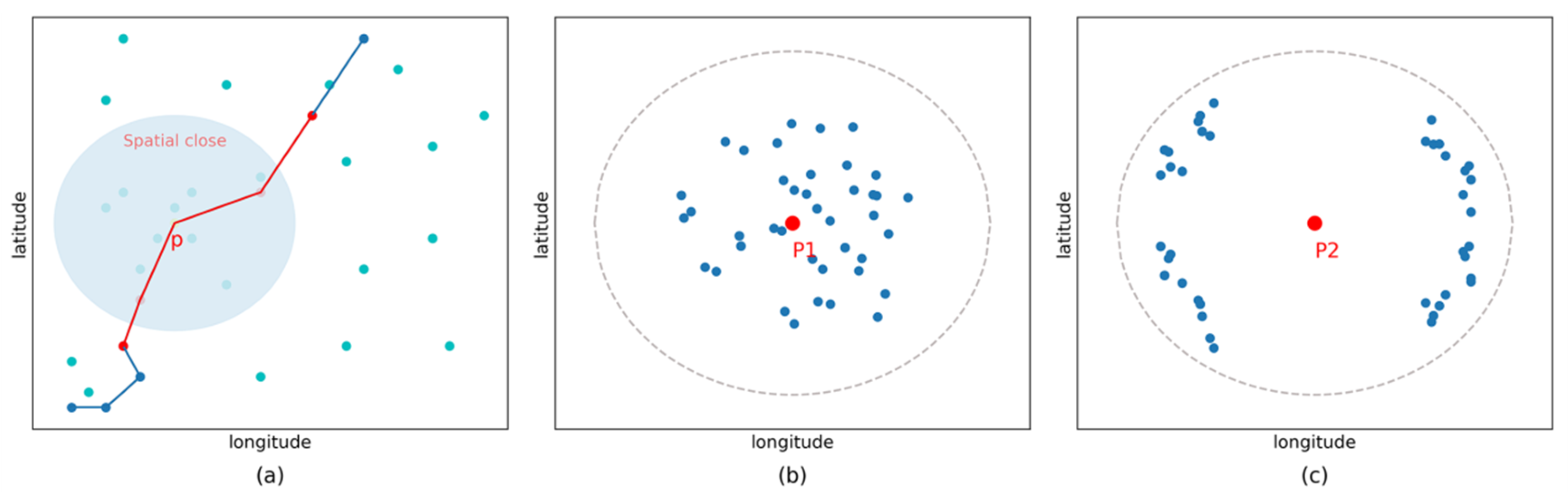
2.1. DBIC
2.2. Classification with M-CNN
2.2.1. 1-D Convolution
2.2.2. 2-D Convolution
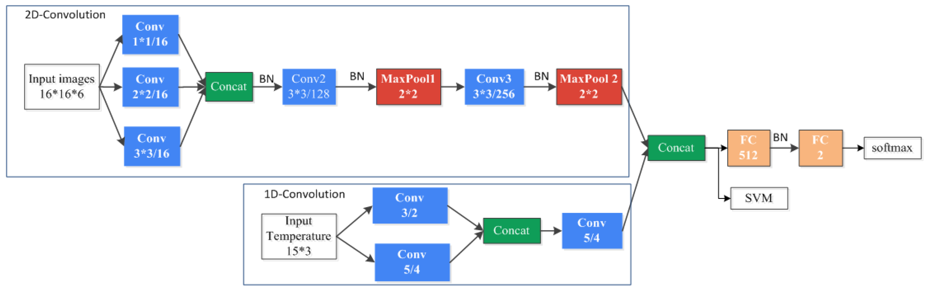
2.2.3. Network Architecture of Our Method
3. Experiment
3.1. Data
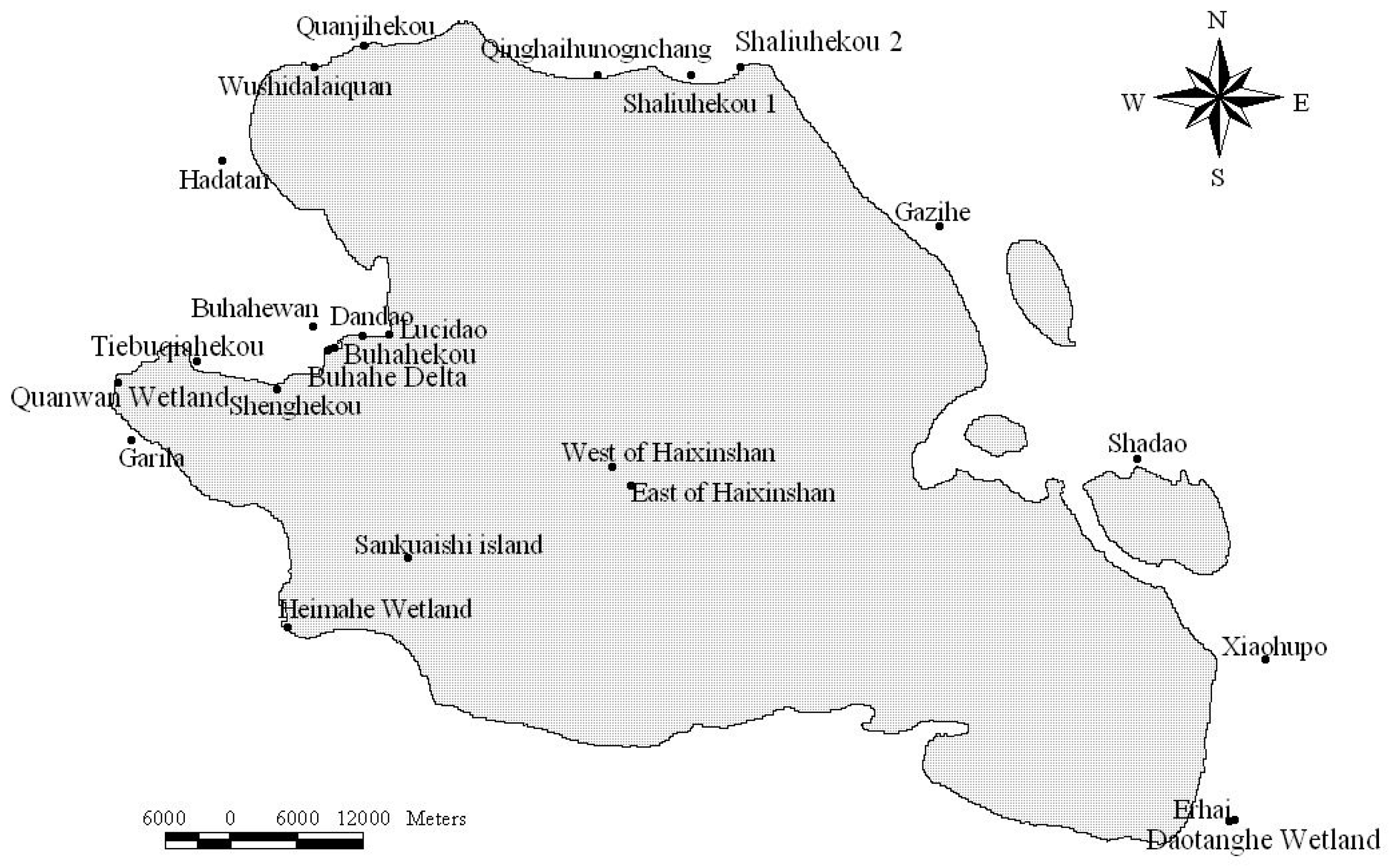
3.1.1. Movement Data
3.1.2. Landsat 5 TM
3.1.3. Temperature Data
3.1.4. Data Augmentation
3.2. Baseline Method
3.3. Experimental Setup
4. Results
4.1. Classification Results
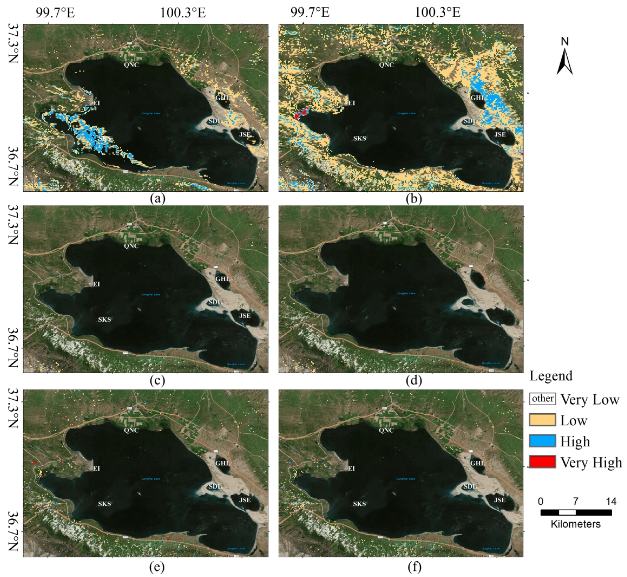
4.2. Prediction Results
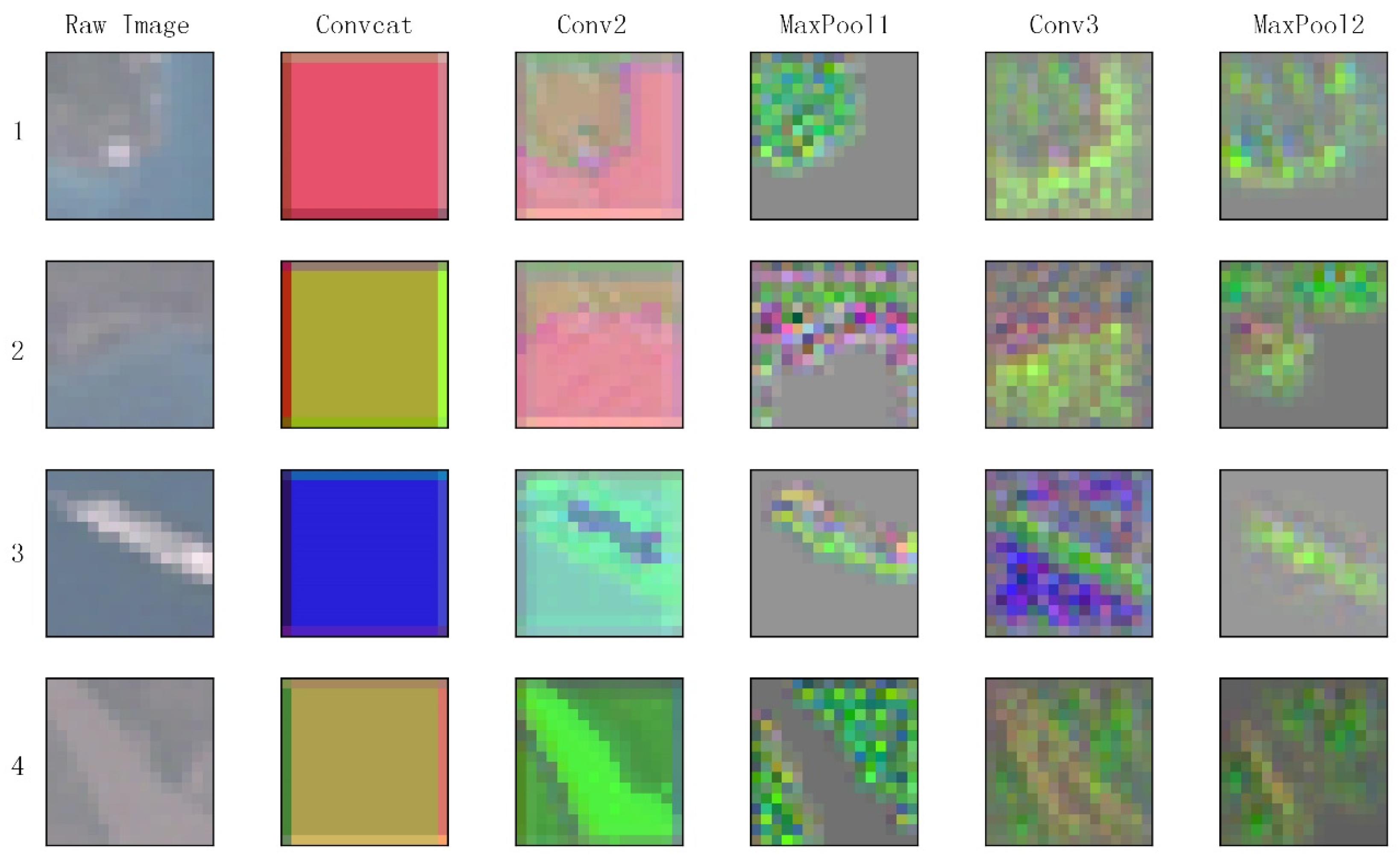
4.3. Visualization of Feature Maps
5. Discussion
6. Conclusions
Author Contributions
Acknowledgments
Conflicts of Interest
References
- Nielsen, S.E.; Johnson, C.J.; Heard, D.C.; Boyce, M.S. Can models of presence-absence be used to scale abundance? Two case studies considering extremes in life history. Ecography 2005, 28, 197–208. [Google Scholar] [CrossRef]
- Hu, J.H.; Hu, H.J.; Jiang, Z.G. The impacts of climate change on the wintering distribution of an endangered migratory bird. Oecologia 2010, 164, 555–565. [Google Scholar] [CrossRef] [PubMed]
- Bisrat, S.A.; White, M.A.; Beard, K.H.; Richard Cutler, D. Predicting the distribution potential of an invasive frog using remotely sensed data in Hawaii. Divers. Distrib. 2012, 18, 648–660. [Google Scholar] [CrossRef]
- Parviainen, M.; Zimmermann, N.E.; Heikkinen, R.K.; Luoto, M. Using unclassified continuous remote sensing data to improve distribution models of red-listed plant species. Biodivers. Conserv. 2013, 22, 1731–1754. [Google Scholar] [CrossRef]
- Busby, J.R. A biogeoclimatic analysis of Nothofagus cunninghamii (Hook.) Oerst. in southeastern Australia. Austral Ecol. 1986, 11, 1–7. [Google Scholar] [CrossRef]
- Lee, S.; Choi, J.K.; Park, I.; Koo, B.J.; Ryu, J.H.; Lee, Y.K. Application of geospatial models to map potential Ruditapes philippinarum habitat using remote sensing and GIS. Int. J. Remote Sens. 2014, 35, 3875–3891. [Google Scholar] [CrossRef]
- Lee, S.; Park, I.; Koo, B.J.; Ryu, J.H.; Choi, J.K.; Woo, H.J. Macrobenthos habitat potential mapping using GIS-based artificial neural network models. Mar. Pollut. Bull. 2013, 67, 177–186. [Google Scholar] [CrossRef] [PubMed]
- Bino, G.; Levin, N.; Darawshi, S.; Hal, N.V.D.; Reich-Solomon, A.; Kark, S. Accurate prediction of bird species richness patterns in an urban environment using Landsat-derived NDVI and spectral unmixing. Int. J. Remote Sens. 2008, 29, 3675–3700. [Google Scholar] [CrossRef]
- Hassan, Q.K.; Bourque, C.P. Potential species distribution of balsam fir based on the integration of biophysical variables derived with remote sensing and process-based methods. Remote Sens. 2009, 1, 393–407. [Google Scholar] [CrossRef]
- Wilson, J.W.; Sexton, J.O.; Todd, J.R.; Haddad, N.M. The relative contribution of terrain, land cover, and vegetation structure indices to species distribution models. Biol. Conserv. 2013, 164, 170–176. [Google Scholar] [CrossRef]
- Cord, A.F.; Klein, D.; Gernandt, D.S.; Jap, L.R.; Dech, S.; Mcgeoch, M. Remote sensing data can improve predictions of species richness by stacked species distribution models: A case study for Mexican pines. J. Biogeogr. 2014, 41, 736–748. [Google Scholar] [CrossRef]
- He, K.S.; Bradley, B.A.; Cord, A.F.; Rocchini, D.; Tuanmu, M.N.; Schmidtlein, S.; Turner, W.; Wegmann, M.; Pettorelli, N. Will remote sensing shape the next generation of species distribution models? Remote Sens. Ecol. Conserv. 2015, 1, 4–18. [Google Scholar] [CrossRef]
- Buermann, W.; Saatchi, S.; Smith, T.B.; Zutta, B.R.; Chaves, J.A.; Milá, B.; Graham, C.H. Predicting species distributions across the Amazonian and Andean regions using remote sensing data. J. Biogeogr. 2008, 35, 1160–1176. [Google Scholar] [CrossRef]
- Lecun, Y.; Bengio, Y.; Hinton, G. Deep learning. Nature 2015, 521, 436. [Google Scholar] [CrossRef] [PubMed]
- Krizhevsky, A.; Sutskever, I.; Hinton, G.E. ImageNet classification with deep convolutional neural networks. In Proceedings of the International Conference on Neural Information Processing Systems, Lake Tahoe, NV, USA, 3–6 December 2012; pp. 1097–1105. [Google Scholar]
- Simonyan, K.; Zisserman, A. Very Deep Convolutional Networks for Large-Scale Image Recognition. arXiv, 2014; arXiv:1409.1556. [Google Scholar]
- Szegedy, C.; Liu, W.; Jia, Y.; Sermanet, P.; Reed, S.; Anguelov, D.; Erhan, D.; Vanhoucke, V.; Rabinovich, A. Going deeper with convolutions. arXiv, 2014; arXiv:1409.4842. [Google Scholar]
- Russakovsky, O.; Deng, J.; Su, H.; Krause, J.; Satheesh, S.; Ma, S.; Huang, Z.; Karpathy, A.; Khosla, A.; Bernstein, M. ImageNet Large Scale Visual Recognition Challenge. Int. J. Comput. Vis. 2015, 115, 211–252. [Google Scholar] [CrossRef]
- Liu, N.; Wan, L.; Zhang, Y.; Zhou, T.; Huo, H.; Fang, T. Exploiting Convolutional Neural Networks with Deeply Local Description for Remote Sensing Image Classification. IEEE Access 2018, 6, 11215–11228. [Google Scholar] [CrossRef]
- Fu, G.; Liu, C.; Zhou, R.; Sun, T.; Zhang, Q. Classification for High Resolution Remote Sensing Imagery Using a Fully Convolutional Network. Remote Sens. 2017, 9, 498. [Google Scholar] [CrossRef]
- Maggiori, E.; Tarabalka, Y.; Charpiat, G.; Alliez, P. Convolutional Neural Networks for Large-Scale Remote-Sensing Image Classification. IEEE Trans. Geosci. Remote Sens. 2016, 55, 645–657. [Google Scholar] [CrossRef]
- Sharma, A.; Liu, X.; Yang, X.; Shi, D. A patch-based convolutional neural network for remote sensing image classification. Neural Netw. Off. J. Int. Neural Netw. Soc. 2017, 95, 19. [Google Scholar] [CrossRef] [PubMed]
- Zhang, H.; Li, Y.; Zhang, Y.; Shen, Q. Spectral-spatial classification of hyperspectral imagery using a dual-channel convolutional neural network. Remote Sens. Lett. 2017, 8, 438–447. [Google Scholar] [CrossRef]
- Mboga, N.; Persello, C.; Bergado, J.; Stein, A. Detection of Informal Settlements from VHR Images Using Convolutional Neural Networks. Remote Sens. 2017, 9, 1106. [Google Scholar] [CrossRef]
- Salberg, A.-B. Detection of seals in remote sensing images using features extracted from deep convolutional neural networks. In Proceedings of the Geoscience and Remote Sensing Symposium, Milan, Italy, 26–31 July 2015; pp. 1893–1896. [Google Scholar]
- Ester, M.; Kriegel, H.P.; Xu, X. A density-based algorithm for discovering clusters a density-based algorithm for discovering clusters in large spatial databases with noise. In Proceedings of the International Conference on Knowledge Discovery and Data Mining, Portland, OR, USA, 2–4 August 1996; pp. 226–231. [Google Scholar]
- Birant, D.; Kut, A. ST-DBSCAN: An Algorithm for Clustering Spatial-Temporal Data; Elsevier Science Publishers B. V.: New York, NY, USA, 2007; pp. 208–221. [Google Scholar]
- Deng, J.; Dong, W.; Socher, R.; Li, L.J.; Li, K.; Li, F.F. ImageNet: A large-scale hierarchical image database. In Proceedings of the 2009 IEEE Conference on Computer Vision and Pattern Recognition, Miami, FL, USA, 20–25 June 2009; pp. 248–255. [Google Scholar]
- Lecun, Y.; Bottou, L.; Bengio, Y.; Haffner, P. Gradient-based learning applied to document recognition. Proc. IEEE 1998, 86, 2278–2324. [Google Scholar] [CrossRef]
- Scherer, D.; Behnke, S. Evaluation of pooling operations in convolutional architectures for object recognition. In Proceedings of the International Conference on Artificial Neural Networks, Thessaloniki, Greece, 15–18 September 2010; pp. 92–101. [Google Scholar]
- Hu, W.; Huang, Y.; Wei, L.; Zhang, F.; Li, H. Deep Convolutional Neural Networks for Hyperspectral Image Classification. J. Sens. 2015, 2015, 1–12. [Google Scholar] [CrossRef]
- EarthExplorer. Available online: https://earthexplorer.usgs.gov/ (accessed on 15 April 2018).
- NOOA. Available online: http://gis.ncdc.noaa.gov (accessed on 15 April 2018).
- Haralick, R.M.; Shanmugam, K.; Dinstein, I.H. Textural Features for Image Classification. IEEE Trans. Syst. Man Cybern. 1973, SMC-3, 610–621. [Google Scholar] [CrossRef]
- Kuffer, M.; Pfeffer, K.; Sliuzas, R.; Baud, I. Extraction of Slum Areas From VHR Imagery Using GLCM Variance. IEEE J. Sel. Top. Appl. Earth Observ. Remote Sens. 2016, 9, 1830–1840. [Google Scholar] [CrossRef]
- Huang, G.; Liu, Z.; Weinberger, K.Q. Densely Connected Convolutional Networks. In Proceedings of the 2017 IEEE Conference on Pattern Recognition and Computer Vision (CVPR), Honolulu, HI, USA, 21–26 July 2017. [Google Scholar]
- Swets, J.A. Measuring the accuracy of diagnostic systems. Science 1988, 240, 1285–1293. [Google Scholar] [CrossRef] [PubMed]
- Bishop, M.A.; Yanling, S.; Zhouma, C.; Binyuan, G. Bar-headed Geese Anser indicus wintering in South-central Tibet. Wildfowl 1997, 48, 118–126. [Google Scholar]
- Cui, P.; Hou, Y.; Tang, M.; Zhang, H.; Zhou, Y.; Yin, Z.; Li, T.; Guo, S.; Xing, Z.; He, Y. Movement patterns of Bar-headed Geese Anser indicus during breeding and post-breeding periods at Qinghai Lake, China. J. Ornithol. 2011, 152, 83–92. [Google Scholar] [CrossRef]
- Takekawa, J.Y.; Heath, S.R.; Douglas, D.C.; Perry, W.M.; Javed, S.; Newman, S.H.; Suwal, R.N.; Rahmani, A.R.; Choudhury, B.C.; Prosser, D.J. Geographic variation in bar-headed geese Anser Indicus : Connectivity of wintering areas and breeding grounds across a broad front. Wildfowl 2009, 59, 100–123. [Google Scholar]
- Zeiler, M.D.; Fergus, R. Visualizing and Understanding Convolutional Networks. In Computer Vision—ECCV 2014; Springer: Cham, Switzerland, 2014; Volume 8689, pp. 818–833. [Google Scholar]
- Glorot, X.; Bengio, Y. Understanding the difficulty of training deep feedforward neural networks. J. Mach. Learn. Res. 2010, 9, 249–256. [Google Scholar]
- Zhang, G.G.; Liu, D.P.; Hou, Y.Q.; Jiang, H.X.; Dai, M.; Qian, F.W.; Lu, J.; Ma, T.; Chen, L.X.; Xing, Z. Migration routes and stopover sites of Pallas’s Gulls Larus ichthyaetus breeding at Qinghai Lake, China, determined by satellite tracking. Forktail 2014, 30, 104–108. [Google Scholar]
- Zhang, Y.N.; Hao, M.Y. Simulation of Population Dynamics of Bar-Headed Geese (Anser Indicus) around Qinghai Lake Region with STELLA. In Proceedings of the First IEEE International Conference on Information Science and Engineering, Nanjing, China, 26–28 December 2009; pp. 5104–5108. [Google Scholar]


| Lat | Lon | Animal | Time |
|---|---|---|---|
| 36.132 | 98.805 | 67,580 | 23 June 2007 15:16:04 |
| 36.609 | 99.19 | 67,580 | 23 July 2007 10:21:46 |
| 99.782 | 36.935 | 67,695 | 1 October 2007 5:00:00 |
| Layers | DenseNet | Output Size |
|---|---|---|
| Convolution | 7 × 7/48 | 16 × 16 |
| Max Pool | 2 × 2 | 8 × 8 |
| Dense Block 1 | 8 × 8 | |
| Transition Layer 1 | 1 × 1 conv | 8 × 8 |
| 2 × 2 average pool | 4 × 4 | |
| Dense Block2 | 4 × 4 | |
| Transition Layer 2 | 1 × 1 conv | 4 × 4 |
| 2 × 2 average pool | 2 × 2 | |
| Dense Block 3 | 2 × 2 | |
| Classification Layer | global average pool | 1 × 1 |
| SoftMax | 1 |
| Training% | Validation% | Testing% |
|---|---|---|
| 70 | 5 | 25 |
| 70 | 10 | 20 |
| 70 | 15 | 15 |
| 70 | 20 | 10 |
| Method | Accuracy | F1 | AUC | Precision | Recall |
|---|---|---|---|---|---|
| GLCM + SVM | 0.769 ± 0.004 | 0.731 ± 0.005 | 0.839 ± 0.004 | 0.742 ± 0.005 | 0.719 ± 0.006 |
| DenseNet | 0.781 ± 0.023 | 0.768 ± 0.008 | 0.870 ± 0.008 | 0.713 ± 0.045 | 0.840 ± 0.060 |
| CNN | 0.803 ± 0.004 | 0.758 ± 0.018 | 0.880 ± 0.013 | 0.814 ± 0.038 | 0.715 ± 0.066 |
| CNN + SVM | 0.817 ± 0.008 | 0.780 ± 0.010 | 0.879 ± 0.011 | 0.817 ± 0.018 | 0.746 ± 0.016 |
| M-CNN | 0.835 ± 0.019 | 0.830 ± 0.021 | 0.936 ± 0.020 | 0.746 ± 0.027 | 0.938 ± 0.041 |
| M-CNN + SVM | 0.864 ± 0.022 | 0.842 ± 0.029 | 0.928 ± 0.015 | 0.852 ± 0.017 | 0.832 ± 0.044 |
© 2018 by the authors. Licensee MDPI, Basel, Switzerland. This article is an open access article distributed under the terms and conditions of the Creative Commons Attribution (CC BY) license (http://creativecommons.org/licenses/by/4.0/).
Share and Cite
Su, J.-H.; Piao, Y.-C.; Luo, Z.; Yan, B.-P. Modeling Habitat Suitability of Migratory Birds from Remote Sensing Images Using Convolutional Neural Networks. Animals 2018, 8, 66. https://doi.org/10.3390/ani8050066
Su J-H, Piao Y-C, Luo Z, Yan B-P. Modeling Habitat Suitability of Migratory Birds from Remote Sensing Images Using Convolutional Neural Networks. Animals. 2018; 8(5):66. https://doi.org/10.3390/ani8050066
Chicago/Turabian StyleSu, Jin-He, Ying-Chao Piao, Ze Luo, and Bao-Ping Yan. 2018. "Modeling Habitat Suitability of Migratory Birds from Remote Sensing Images Using Convolutional Neural Networks" Animals 8, no. 5: 66. https://doi.org/10.3390/ani8050066
APA StyleSu, J.-H., Piao, Y.-C., Luo, Z., & Yan, B.-P. (2018). Modeling Habitat Suitability of Migratory Birds from Remote Sensing Images Using Convolutional Neural Networks. Animals, 8(5), 66. https://doi.org/10.3390/ani8050066