1. Introduction
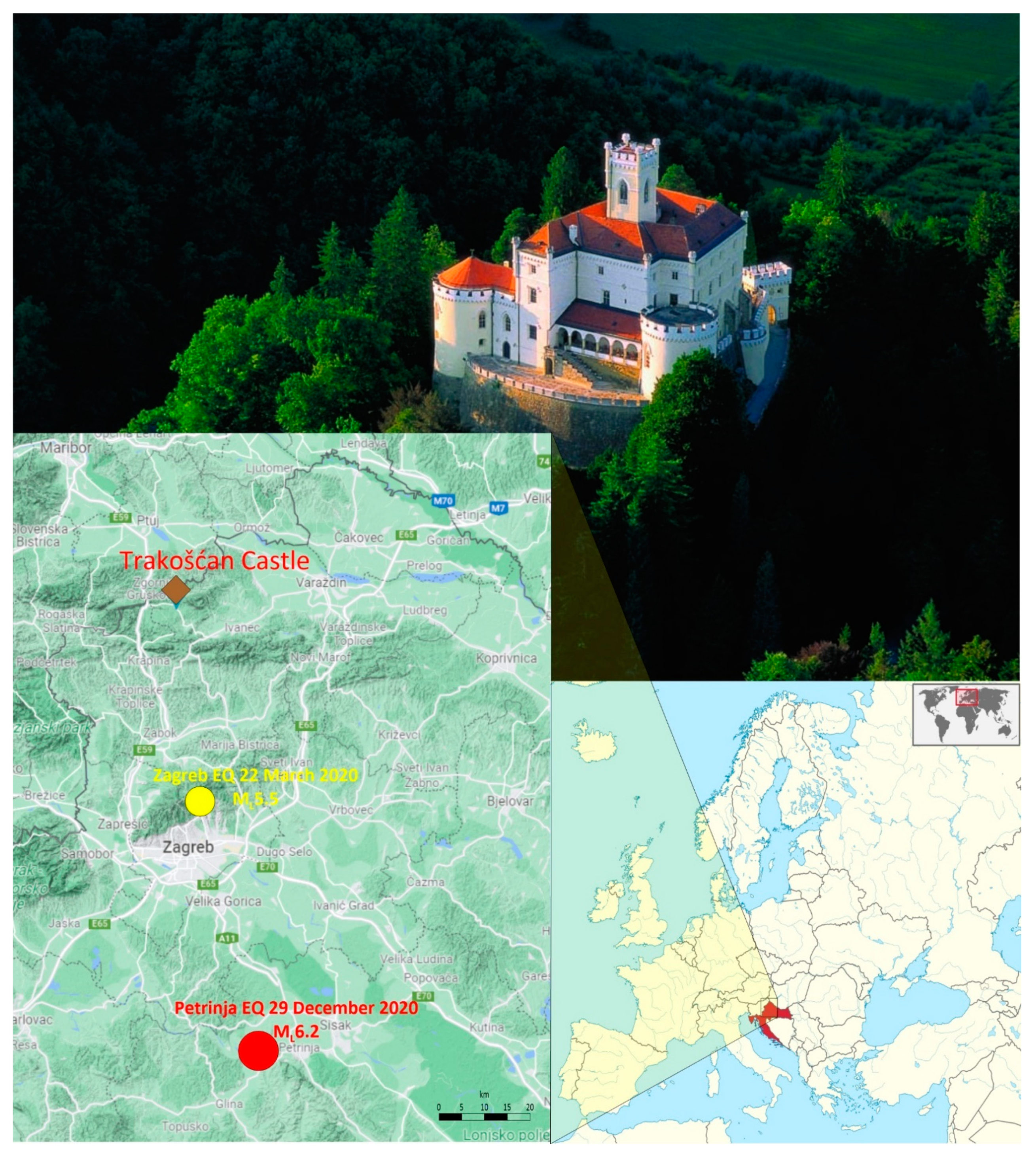
Trakošćan Castle is protected as a cultural heritage site and an important historical entity by the Republic of Croatia (
Figure 1). The Castle site is located in the Varaždin-Ivanščica-Kozjansko source area [
1] and lies in the Lepoglava syncline alluvial sediments of the Bednja River, between Mt. Ivanščica and Mt. Ravna Gora. Serious earthquake damage to Trakošćan Castle was caused by the 16 March 1982 M4.5 earthquake [
2]. After that, the Castle was under significant structural restoration and conservation until the 2000s. All that time it was open to visitors, apart from the Castle’s tower.
Two earthquakes, the Zagreb M5.5 on 22 March 2020 [
3,
4] and the Petrinja M6.2 on 29 December 2020 [
5,
6,
7], have strongly shaken the Castle’s structure. Immediately after the Petrinja earthquake, visual inspection of the damage at Trakošćan Castle was performed accompanied by ambient vibration measurements.
Celebi et al. [
8] showed that nonductile, unreinforced older historical buildings that were damaged in earthquakes responded with the shortening of structural frequencies (the structure is softening, structural stiffness is loosened) that correspond to dominant frequencies of input motions. Shaking durations, as observed during the Petrinja M6.2 earthquake, and higher accelerations (e.g., local site effects in the Trakošćan area), combined with the lack of ductility in historical buildings, may play a significant role in collapse or heavy damage, particularly if the frequency content of given input motions is similar to the fundamental frequency of the structure itself.
Therefore, the main aim of this study is two-fold: (a) the assessment of earthquake damage in the Castle after the earthquakes that occurred in 2020, and (b) the comparison of pre- (2016) and post-earthquake (2021) ambient vibration measurements of critical points. Pre- and post-earthquake ambient vibration measurements in historical buildings can help to identify potential hidden cracks in thick walls and to detect potential weak points in the complex structure [
9,
10]. Changes in the fundamental frequencies can provide a useful tool for vulnerability diagnosis [
11,
12].
This study, together with previous ones of the Trakošćan area [
13,
14], is the basis for future studies of the Castle’s seismic performance and protection for the purpose of ret-rofitting to withstand future earthquakes. This requires careful interpretation by the use of theoretical analysis and empirical data. The conservation and earthquake protection of historical buildings is one of the key issues of contemporary engineering. This requires multidisciplinary cooperation (e.g., seismologists, geotechnical engineers, geologists, civil construction engineers, structural engineers, archaeologists, restorers, government, monumental institutions, etc.).
This paper presents initial steps/analyses that were taken towards assessing Trakošćan Castle’s seismic hazard and vulnerability. Here, it should be mentioned that this will be further evaluated in detail in the frame of the ongoing Croatian Science Foundation Research Project (IP-2020-02-3531): Seismic risk assessment of cultural heritage buildings in Croatia (SeisRICHerCRO). Detailed seismic hazard analysis will be performed including probabilistic and scenario-based analysis as well as the determination of local site response. Further extensive 3D non-linear static analysis is foreseen in order to correctly evaluate the seismic vulnerability of the building, i.e., its structural performances.
2. Seismicity of the Wider Trakošćan Area
Besides earthquake shaking, seismic hazard is strongly dependent on local soil effects. Local site amplification effects are the result of several physical processes (e.g., multiple reflections and diffractions, focusing, resonance, wave trapping) in the overlying surface deposits and soil, resulting in variable damage distribution that was observed in different local geological units, which certainly contributed to an increased seismic hazard. For this reason, detailed analysis of the seismicity of the wider Trakošćan area is performed. In addition to instrumental seismic activity (the period after 1906 when instrumental data on earthquakes exist), historical seismicity has been described, which includes earthquakes that occurred in the period BC–1906, and whose parameters were determined on the basis of reliable macroseismic data.
The seismicity of the investigated area is characterized by the occurrence of a small number of strong earthquakes (predominantly historical) and a larger number of weaker ones (of the total number of earthquakes that occurred here, 92% were of a magnitude less than or equal to 2.5). The locations of the stronger earthquakes align over the SW–NE direction (
Figure 2).
In the Croatian Earthquake Catalog (CEC, updated version first described in [
15]), the first data (unfortunately very unreliable) about a strong earthquake in the wider Trakošćan Castle area can be found in 1459. It is an earthquake with an epicenter close to Varaždin and with an estimated epicentral intensity of IX MCS. Additionally, together with the great Dubrovnik 1667 earthquake, it is the strongest event in the CEC.
After that, in 1836, two very strong earthquakes (of magnitudes 5.9 and 4.7) occurred at the foot of Mt. Ivanščica. As [
16] states: “… the strongest chimneys in Zajezda collapsed, the walls of the building cracked, and people who were lying in a deep sleep were thrown out of bed”.
In 1838, a strong M5.3 earthquake occurred in Međimurje and Zalad County (Hungary), which is known to have caused damage in several locations (cracks appeared in the walls, and some houses were allegedly also demolished, according to [
17]). The earthquake stirred and blurred the Mura river, and small fishes were thrown ashore.
At an almost identical location as the events of 1836, a strong earthquake of magnitude 4.7 and epicentral intensity VI MCS occurred in 1905. Kišpatić [
18] states that there was a lot of damage from that earthquake, and even in Varaždin several houses were damaged, where the chimneys were mostly damaged.
After 1906, only three M4.5+ earthquakes occurred in the wider area of Trakošćan. The first two, of magnitude 4.6, were in 1925 and 1967, located 40 km WSW of Ivanec and 8 km SSW of Krapina, respectively. The last of these three earthquakes was in 1982 at the foot of Mt. Ivanščica, with a magnitude of 4.5. This last earthquake damaged buildings not only in the area of Mt. Ivanščica, but all the way to Pregrada, and especially severely damaged cultural monuments.
In addition to earthquakes that occur in the immediate vicinity of a particular object/building, damage can also be caused by stronger earthquakes that occur at greater distances. Such was the case with the earthquakes that occurred in 2020 in Zagreb and Petrinja.
2.1. The Zagreb M5.5 Earthquake in March 2020
On 22 March 2020, Zagreb was struck by a M5.5 earthquake, the strongest one in the last 140 years, which revealed all the failures in the construction of residential buildings in the Croatian capital, especially those built in the first half of the 20th century. Based on the preliminary spatial and temporal analysis of the Zagreb 2020 earthquake sequence [
4], it is evident that the mainshock and the first aftershocks occurred in the subsurface of Mt. Medvednica along the deep-seated southeast dipping thrust fault, recognized as a primary fault. The co-seismic rupture propagated during the first half an hour of the earthquake sequence along the thrust towards the northwest, which can be clearly seen from the time lapse visualization. The location of the main earthquake from Trakošćan Castle was approximately 40 km.
The main earthquake was felt with a maximal intensity of VII EMS (
Figure 3) and was felt all over Croatia, even at a distance of more than 1000 km from the epicenter (see Figure 3 in [
4]).
The earthquake hit the city center hardest, and the initial information indicated that the damage was meaningful. A number of damages to the cultural and historical architectural heritage of Zagreb have been reported, with severe damage to the south tower of Zagreb Cathedral. Damage was reported not only in the city of Zagreb but also in the surrounding areas. There was a large number of aftershocks following the main event (more than 300 with M1.3+ in the next six months [
19]). The mainshock was felt in the Trakošćan area with an intensity of V EMS.
2.2. The Petrinja M6.2 Earthquake in December 2020
On 28 December, 2020, in the early morning hours, a strong M5 earthquake occurred with an epicenter about 6 km SW of Petrinja. The next day, 29 December, just after noon, a destructive M6.2 earthquake occurred in the same area, which, in addition to major damage in the wider epicentral area, also caused human casualties. These two earthquakes were also the strongest in the seismic sequence that took place in the Petrinja-Pokupsko area. The M5 foreshock proved to have saved many human lives, since it forced many inhabitants to flee their homes. The mainshock occurred at approximately 90 km from the position of Trakošćan Castle.
Reported damage was widespread, with many destroyed or damaged buildings and structures in towns near the epicenter, especially Petrinja and Sisak. Until 31 December, more than 1300 M1.5+ aftershocks were located, including 12 events of magnitudes 4–4.8. The larger events added damage to already weakened structures and caused additional collapse. Hundreds of people, evacuated from their homes, were transferred to makeshift shelters, hotels and other temporary accommodation in the wider area. The mainshock was felt in the Trakošćan area with an intensity of V EMS (
Figure 4).
3. Ambient Vibration Measurements: Pre- and Post-Earthquakes
In 2016, [
13] used the non-destructive Horizontal-to-Vertical Spectral Ratio (HVSR) method to estimate the local seismic response and vulnerability of the historical Trakošćan Castle. Microtremor measurements were taken in the free field and in the Castle’s tower for the purpose of detecting the local seismic response and structural seismic vulnerability of the weak points of the Castle.
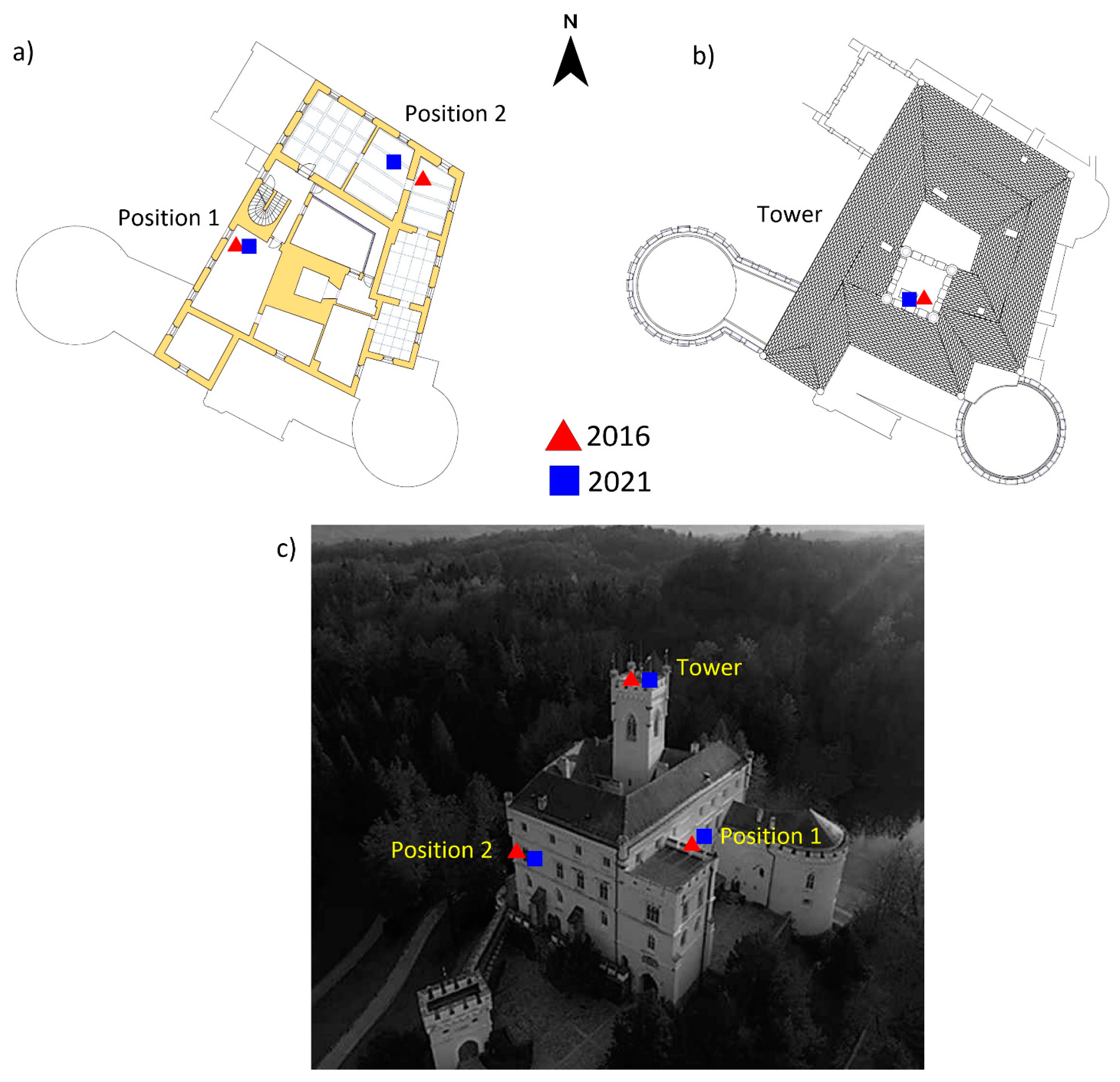
In the beginning of 2021, after the Zagreb March 2020 and the Petrinja December 2020 earthquakes, ambient noise measurements were performed on the same locations as in 2016, on the top of the Castle’s tower and at two positions on the 2nd floor (
Figure 5). The instrument (Tromino, Moho s.rl.) was oriented parallel to the longer axis of the Castle and positioned following a close vertical alignment with the same orientation on each floor. Each recording lasted for 10 min with a 128 Hz sampling rate. The dynamic behavior of the Castle’s tower and 2nd floor is demonstrated by the comparison of the HVSR frequency analysis, based on 2016 and 2021 measurements, for the horizontal components (NS/V and EW/V) and for all three mentioned locations of the Castle (
Figure 6,
Figure 7 and
Figure 8). The data reveal that a clear shift of the fundamental peak (and first higher mode) in NS/V and EW/V components for all three locations exists.
Table 1 summarizes fundamental frequencies and periods from the 2016 [
13] and 2021 (this study) ambient noise measurements, clearly showing the decrease in the fundamental frequency (increase in period) of the Castle’s central tower unit and the second floor.
The variation of the fundamental frequency (period) of a given structure can be attributed to various sources of excitation (e.g., man-made, traffic, earthquakes) and environmental conditions (e.g., temperature, wind). Low-amplitude shaking and environmental conditions on the undamaged structures usually cause small frequency changes [
20]. However, stronger shaking can significantly alter fundamental frequencies due to either visible or hidden cracks in the structure walls [
12]. Such change may further increase if the structure’s fundamental frequency (and higher modes) is synchronized with local site amplification and resonances [
21]. This is exactly what happened in the case of Trakošćan Castle’s 2nd floor (frequencies around 4.5 Hz) and the bottom site on the Bednja river basin (frequencies from 4–6 Hz) [
12]. Site amplifications for these frequencies vary between 2 and 3.5 [
14].
Ground motion amplification is important to be considered for Trakošćan Castle due to topographic effects of the rocky peak hill and soft sediment of the Bednja river basin [
13]. For the Petrinja 2020 event, estimated accelerations exceeded 0.30 g in the epicentral area [
7]. Considering that the approximate distance from the location of the Petrinja 2020 earthquake to the Trakošćan site is 90 km, peak ground acceleration for the rock is estimated between 0.015 and 0.032 g [
7]. If site amplification [
14] is considered, we can estimate that resulting peak ground acceleration was between 0.03 and 0.11 g. Again, if we consider a distance of about 40–50 km from the location of the Zagreb 2020 earthquake to the Trakošćan site, estimated peak ground acceleration using attenuation relation for the rock is about 0.03 g [
22]. With accounted site amplification [
14], ground shaking can be assumed between 0.06 and 0.10 g. We compared these assumed values with recorded ground motions—accelerations for the Zagreb 2020 event recorded on stations 10 km distant from the epicenter were about 0.20 g on alluvial sediment sites [
23], whereas six accelerometric stations in Zagreb recorded the Petrinja 2020 event on different local sites in a range of 0.04 g up to 0.25 g (see analysis of accelerogram for Petrinja earthquake, [
24]).
For Trakošćan Castle, estimated PGA values up to 0.10 g with included local site effects can be considered as strong shaking, which is particularly important for the seismic vulnerability and performance, as the cumulative damage from past earthquakes and the aging process have progressively reduced the strength of construction materials, faulty past repairs or restoration interventions, local soil settlement, damage to building foundations and human influence in comparison to newer RC buildings.
Bar charts in
Figure 9 show that the change in fundamental frequency for the tower and 2nd floor (position 1) is not so significant as the change at the other location on the 2nd floor (position 2) for the average N/V component, where visible cracks were observed. Concerning the latter, the Zagreb M5.5 earthquake induced slight cracks that were spread after the Petrinja M6.2 earthquake. Therefore, the decrease in frequency may potentially suggest the loss of structural stiffness as a consequence of the earthquake damage assessed by visual inspection, accompanied by ambient vibration measurements.
4. Earthquake Damage Inspection
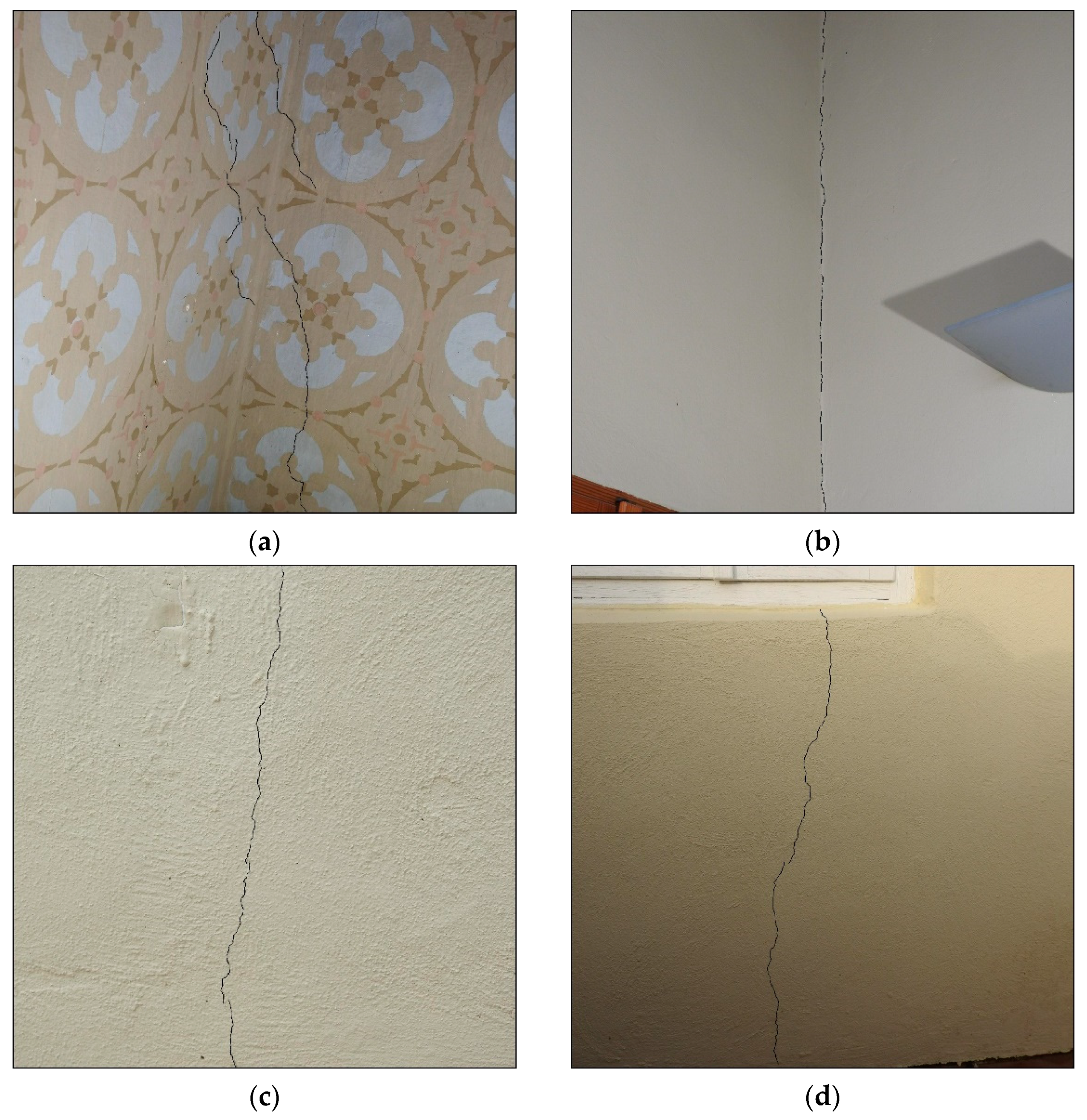
The nature of Trakošćan Castle as a historical cultural heritage entity, its structural form and materials used, stages of construction, site conditions, seismic activity in the region and statutory requirements (retrofitting options) were the factors influencing the degree of incurred earthquake damage. The structure of the 13th century Castle varies in shape. The form and detail of the structure, as well as the materials used, were governed by the fortification engineering of the period of the time and not by seismic considerations. The Castle is thus constructed as a highly irregular masonry (unreinforced) structure of military architecture, with timber beam or shallow masonry arches, vaults or dome flooring. It was substantially renewed and upgraded in the late 16th (artillery towers, upgrade of the central tower and of the upper story) and 18th centuries (defense walls, tower crowns). In 2020, the increased seismic activity in northwestern Croatia, both in rate and strength, was reflected by the two strong shaking events, accompanied by a swarm of intermediate to small earthquakes and minor events. By the in situ visual inspection of the damage to the building after the Petrinja earthquake of 29 December 2020, we observed cracks 1 to 4 mm in width, positioned on façades and in the interior, on masonry lintels, arches, vaults and walls, as shown in
Figure 10 and
Figure 11. IDs referring to damage caused by the Petrinja 2020 earthquake contain both digits and letters (a, b, c, etc.), since the second event was followed by the expansion of the cracks that appeared during the first event.
As shown in
Figure 10 and
Figure 11, cracking was generally initiated in the vicinity of opening corners or wall ends, and spread throughout the building. The cracks in walls were mostly bound by fine oblique shear cracks. Based on the cracking type, distribution and characteristics (width, length, indentation, direction and location), damage to the building shown in
Figure 10 and
Figure 11 belongs to the class of minor damage (Grade 1: Negligible to slight damage) in compliance with the EMS-98 scale [
25]. Therefore, the observed damage does not pose a threat to the load-bearing capacity and usability of the building (see
Figure 12,
Figure 13,
Figure 14 and
Figure 15 for examples).
The damage marked as 12 (see
Figure 10 and
Figure 11) is a hairline tensile crack < 1 mm wide, formed at the apex of a shallow arch spanning 4.35 m, extending to adjacent arches, from which the arch assumes the corresponding part of the load. Although the crack does not indicate substantial to heavy damage according to the EMS-98 scale, due to the location of its occurrence (arch vertex), proper crack control measures should be taken. The damage marked as 52 (see
Figure 10 and
Figure 11) is a crack < 3 mm wide, and represents slight damage to the part of the 2nd floor wall perpendicular to the outer wall on which the roof structure rests, and is also further weakened by the presence of chimneys. In the observed portion of the wall, the vertically continuous chimneys are placed within the wall. However, the gross wall thickness was kept the same as in the remaining portion of the wall. Therefore, due to the reduction in the net thickness of the wall, the chimneys represent the intrinsic lack of structural integrity of the particular wall or building itself.
Figure 13 and
Figure 14 show the typical damage observed on vaults and arches in the form of sparsely distributed hairline cracks, with length ranging from 2 to 6 m, and in some cases even over 10 m. The majority of cracks are positioned perpendicular across vaults and arches and from there propagate to openings close to them (see
Figure 12b,c). Longitudinal cracks on arches and vaults have been observed above openings in the east tower at floor level (cracks IDs 21, 22 and 23 in the damage distribution map in
Figure 12d). An interesting spatial crack pattern (
Figure 13) has been observed on the ceiling vault of the ground floor (ID 13), where cracks are spread from openings (windows) upwards to the center of the vault. The cracks observed on a vault shown in
Figure 10a (crack ID 13) imply the decomposition of the vault load-bearing structural system to an individual arch system, which represents the new equilibrium of the structure. Above the nearby outer wall, retrofitting measures were carried out with reinforced concrete horizontal confining elements (
Figure 15). However, these measures were inadequate, since there is an interruption of the confining element that makes it ineffective. For this reason, it is necessary to further monitor the development of this crack.
By the visual inspection, we observed the surface manifestations of earthquake damage (cracks in plaster). In general, the building did not suffer substantial cracking to the original and added structure, and cracking that would imply severe or near-collapse damage to the structure or its parts was not observed. However, a detailed inspection is required to determine repair and retrofitting measures in order to reduce vulnerability to the best standard possible in order to withstand future earthquakes. The problems also involve an adequate earthquake performance representation by means of theoretical simulation. To obtain the desirable outcome, the determination of the characteristics of the materials is essential, as well as plaster removal in order to observe the depth and propagation of the cracks. Although the conclusions of this study are still in the tentative stage, they provide valuable information on building seismic behavior and a basis for a further detailed investigation, i.e., for the purpose of structural modeling and decisions on structural intervention. Therefore, a brief summary of the key findings is included here.
5. Discussion and Conclusions
Assessing the seismic risk of a single building or building aggregate derives from the convolution of three main parameters that need to be evaluated: seismic hazard (possibility of future seismic shaking), seismic vulnerability (weakness of the structure/s in respect to seismic shaking) and exposure (the element/s of interest at risk). Since Trakošćan Castle was selected as a case study building in this paper, it should be mentioned that its seismic hazard and vulnerability will be further evaluated in detail in the frame of ongoing Croatian Science Foundation Research Project (IP-2020-02-3531): Seismic risk assessment of cultural heritage buildings in Croatia (SeisRICHerCRO). Detailed seismic hazard analysis will be performed including probabilistic and scenario-based analysis as well as the determination of local site response. Further extensive 3D non-linear static analysis is foreseen in order to correctly evaluate the global seismic vulnerability of the building, i.e., its structural performance.
This paper presents initial steps/analyses that were taken towards assessing the building’s seismic vulnerability. As a preliminary and first step, detailed knowledge on the building’s geometry was acquired through the available technical documentation and several on-site visits. Further steps foreseen in geometry identification through the mentioned Croatian Science Foundation Research Project will be a 3D-laser-scanner survey, which, along with the technical documentation, will provide maximum precise information about the complex building geometry.
Although fully restored and conserved lastly in 2000, Trakošćan Castle was struck afterwards by the Zagreb March 2020 and the Petrinja December 2020 earthquakes, which caused visual damage and cracks on the Castle complex. In that regard, apart from the visual inspection of the building aimed at marking and categorizing the damages/cracks, it was decided that performing ambient vibration measurements was necessary to detect potential changes in the dynamic properties of the building since the existence of pre-earthquake ambient vibration measurements [
13,
14]. The comparative analysis of pre (2016) and post (2021) earthquake ambient vibration measurements (
Figure 6,
Figure 7,
Figure 8 and
Table 1) demonstrates the clear shift of the predominant frequencies towards a lower range, which indicates the presence of plastic deformations (cracks) in the load-bearing walls of the Castle. The microtremor measurements performed in the vicinity of the Castle (bottom site of the Bednja river basin) with a predominant frequency range of 4–6 Hz imply the existence of possible resonant conditions with the main Castle building (4.5 Hz), which can be inferred as an additional reason for the present extent of damage.
During the visual inspection held after the two recent earthquakes (occurred in 2020), out of which the Petrinja M6.2 earthquake caused stronger shaking, a systematic identification and classification of cracks was made. Identified visible cracks were dominantly found on façades and interior walls and on masonry lintels, arches and vaults (
Figure 10 and
Figure 11). All identified cracks were characterized with their width, length, indentation, direction and location. It should be mentioned that, after the second earthquake, some of the initial cracks were widened and new ones appeared. However, the visual inspection indicates that most of the cracks were found in the plaster, with a predominant width of about 1–4 mm, which classifies them in grade 1 (negligible to slight damage) in compliance with the EMS-98 scale (
Figure 12,
Figure 13,
Figure 14 and
Figure 15).
The cracking on the surface of the Castle’s structural components indicates no severe or near-collapse structural damage. The measurements of the fundamental period of the structure (
Figure 6,
Figure 7,
Figure 8 and
Table 1), prior to and after the earthquake events, showed the period increase. This implies that the observed cracking is not related merely to the structural component’s plaster coating, but for the structure itself as well. This will require further on-site assessment, as well as numerical and experimental analyses to assess the real condition of the building, which will be the basis for proposing adequate prevention and rehabilitation measures. Rigorous and detailed vulnerability assessment of such historic buildings and the implementation of appropriate retrofitting solutions can help to reduce the levels of physical damage, loss of life and the economic impact of future seismic events. However, we need to note that it is planned to install accelerometers for continuous measurement of microseismic noise and potential earthquakes inside selected buildings (one of them is Trakošćan Castle), which will help us to monitor if estimated dynamic characteristics of buildings and structural building integrity have been affected in the case of an earthquake. This is one of the objectives of the project SeisRICHerCRO.
Strategies focused on the prevention of and a reduction in seismic risk are largely based on the seismic assessment of existing masonry buildings because, in most countries, they represent the majority of the existing building stock, as well as the prevailing structural typology of cultural and historical monuments. Croatia is one of the countries that abounds with cultural heritage buildings and sites, with tens of them currently under UNESCO protection [
26]. The obligation of taking proper care of cultural heritage today is usually prescribed by the law, not only in Croatia but in most countries, which requires planning and implementing continuous restoration and conservation measures. Maintaining the main features of historical buildings comes along with guaranteeing at the same time their structural strength, i.e., the prescribed level of safety with respect to both vertical load and seismic shaking.
Author Contributions
S.M. conceived of the presented idea, described the seismicity of the wider Trakošćan area and coordinated and defined the contributions of other co-authors. D.S. performed and discussed ambient vibration measurements pre- and post-earthquakes. D.P., together with D.T., described the characteristics of the building (Trakošćan Castle) and its earthquake performance, and performed visual in situ earthquake damage inspection. R.Š. gave a contribution to the
Section 5. All authors discussed the results. S.M. took the lead in writing the paper. The other authors also contributed to the paper, provided critical feedback and helped shape the final paper. All authors have read and agreed to the published version of the manuscript.
Funding
This work has been supported by the Croatian Science Foundation under the project HRZZ IP-2020-02-3531 and “Young Researchers’ Career Development Project—Training of Doctoral Students” program.
Institutional Review Board Statement
Not applicable.
Informed Consent Statement
Not applicable.
Data Availability Statement
Not applicable.
Acknowledgments
The authors are thankful to the University of Zagreb, Faculty of Science, Department of Geophysics, Seismological Survey for providing the raw WM recordings of Croatian stations. We are most thankful to the Trakošćan Castle administration for supporting this research. We thank the editor, as well as two anonymous reviewers, for the very constructive criticism on the submitted version of the manuscript.
Conflicts of Interest
The authors declare no conflict of interest. The funders had no role in the design of the study; in the collection, analyses, or interpretation of data; in the writing of the manuscript, or in the decision to publish the results.
References
- Herak, D.; Herak, M.; Tomljenović, B. Seismicity and earthquake focal mechanisms in North-Western Croatia. Tectonophysics 2009, 465, 212–220. [Google Scholar] [CrossRef]
- Trakošćan Castle Historical Evaluation, Trakošćan Castle Museum Archives, 1968–2012; Trakošćan Castle Museum: Bednja, Croatia.
- Latečki, H.; Molinari, I.; Stipčević, J. 3D physics-based seismic shaking scenarios for city of Zagreb, Capital of Croatia. Bull. Earthq. Eng. 2021, 1, 28. [Google Scholar] [CrossRef]
- Markušić, S.; Stanko, D.; Korbar, T.; Belić, N.; Penava, D.; Kordić, B. The Zagreb (Croatia) M5.5 earthquake on 22 March 2020. Geosciences 2020, 10, 252. [Google Scholar] [CrossRef]
- Bjelotomić Oršulić, O.; Markovinović, D.; Varga, M.; Bašić, T. Coseismic ground displacement after the MW6.2 earthquake in NW Croatia determined from sentinel-1 and GNSS CORS data. Geosciences 2021, 11, 170. [Google Scholar] [CrossRef]
- Pollak, D.; Gulam, V.; Novosel, T.; Avanić, R.; Tomljenović, B.; Hećej, N.; Terzić, J.; Stipčević, J.; Bačić, M.; Kurečić, T.; et al. The preliminary inventory of coseismic ground failures related to December 2020–January 2021 Petrinja earthquake series. Geol. Croat. 2021, 74, 189–208. [Google Scholar] [CrossRef]
- Markušić, S.; Stanko, D.; Penava, D.; Ivančić, I.; Bjelotomić Oršulić, O.; Korbar, T.; Sarhosis, V. Destructive M6.2 Petrinja earthquake (Croatia) in 2020—Preliminary multidisciplinary research. Remote Sens. 2021, 13, 1095. [Google Scholar] [CrossRef]
- Celebi, M.; Bazzurro, P.; Chiaraluce, L.; Clemente, P.; Decanini, L.; Desortis, A.; Ellsworth, W.; Gorini, A.; Kalkan, E.; Marcucci, S.; et al. Recorded motions of the 6 April 2009 Mw 6.3 L’Aquila, Italy, earthquake and implications for building structural damage: Overview. Earthq. Spectra 2010, 26, 651–684. [Google Scholar] [CrossRef] [Green Version]
- Gentile, C.; Saisi, A. Ambient vibration testing of historic masonry towers for structural identification and damage assessment. Constr. Build. Mater. 2007, 21, 1311–1321. [Google Scholar] [CrossRef]
- Fiaschi, A.; Matassoni, L.; Pratesi, G.; Garzonio, C.A.; Malesani, P. Microtremor analysis of the Basilica of the Holy Sepulchre, Jerusalem. Soil Dyn. Earthq. Eng. 2012, 41, 14–22. [Google Scholar] [CrossRef]
- Nakamura, Y.; Gurler, E.D.; Saita, J. Dynamic characteristics of leaning tower in Pisa using microtremor—Preliminary results. In Proceedings of the 25th Japan Conference on Earthquake Engineering, Tokyo, Japan, 29–31 July 1999. [Google Scholar]
- Nakamura, Y.; Gurler, E.D.; Saita, J.; Rovelli, A.; Donati, S. Vulnerability investigation of Roman Colosseum using microtremor. In Proceedings of the 12th World Conference on Earthquake Engineering, Auckland, New Zealand, 30 January–4 February 2000. [Google Scholar]
- Stanko, D.; Markušić, S.; Strelec, S.; Gazdek, M. Seismic response and vulnerability of historical Trakošćan Castle using HVSR method. Environ. Earth Sci. 2016, 75, 368. [Google Scholar] [CrossRef]
- Stanko, D.; Markušić, S.; Strelec, S.; Gazdek, M. Equivalent-linear site response analysis on the site of the historical Trakošćan Castle, Croatia using HVSR method. Environ. Earth Sci. 2017, 76, 642. [Google Scholar] [CrossRef]
- Herak, M.; Herak, D.; Markušić, S. Revision of the earthquake catalogue and seismicity of Croatia, 1908–1992. Terra Nova 1996, 8, 86–94. [Google Scholar] [CrossRef]
- Kišpatić, M. Šesto i Sedmo Izvješće Potresnoga Odbora za Godine 1888–1889; Knjiga 11; Jugoslavenske Akademije Znanosti i Umjetnosti: Zagreb, Croatia, 1891. (In Croatian) [Google Scholar]
- Perrey, A. Mémoire sur les tremblements de terre dans le bassin du Danube. Ann. Sci. Phys. Nat. Lyon Lyon Soc. Agric. Ann. 1846, 9, 333–414. [Google Scholar]
- Kišpatić, M. Dvadeset i Treće Potresno Izvješće za Godinu 1905; Knjiga 38; Jugoslavenske Akademije Znanosti i Umjetnosti: Zagreb, Croatia, 1906; pp. 131–180. (In Croatian) [Google Scholar]
- Half Year from the Zagreb Earthquake. Available online: https://www.pmf.unizg.hr/geof/seizmoloska_sluzba/o_zagrebackom_potresu_2020/pola_godine_od_potresa (accessed on 16 April 2021).
- Castellaro, S.; Perricone, L.; Bartolomei, M.; Isani, S. Dynamic characterization of the Eiffel tower. Eng. Struct. 2016, 126, 628–640. [Google Scholar] [CrossRef]
- Castellaro, S.; Padrón, L.A.; Mulargia, F. The different response of apparently identical structures: A far-field lesson from the Mirandola 20th May 2012 earthquake. Bull. Earthq. Eng. 2014, 12, 2481–2493. [Google Scholar] [CrossRef]
- Markušić, S.; Herak, M.; Herak, D.; Ivančić, I. Peak horizontal-to-vertical acceleration ratio and local amplification of strong ground motion. Stud. Geophys. Geod. 2002, 46, 83–92. [Google Scholar] [CrossRef]
- Prevolnik, S.; Markušić, S.; Ivančić, I. Strong ground motion records of the Zagreb earthquake of 22 March 2020. In Proceedings of the 1st Croatian Conference on Earthquake Engineering, 1CroCEE, Zagreb, Croatia, 22–24 March 2021; Lakušić, S., Atalić, J., Eds.; Zagreb Faculty of Civil Engineering: Zagreb, Croatia, 2021. [Google Scholar] [CrossRef]
- Analysis of Accelerograms for Petrinja Earthquakes. Available online: https://www.pmf.unizg.hr/geof/seizmoloska_sluzba/potresi_kod_petrinje_2020 (accessed on 15 February 2021).
- Grünthal, G.; Musson, R.M.W.; Schwarz, J.; Stucchi, M. European Macroseismic Scale EMS-98; Cahiers du Centre Européen de Géodynamique et de Séismologie: Luxembourg, 1998. [Google Scholar]
- Properties Inscribed on the World Heritage List. Available online: https://whc.unesco.org/en/statesparties/hr (accessed on 16 June 2021).
| Publisher’s Note: MDPI stays neutral with regard to jurisdictional claims in published maps and institutional affiliations. |
© 2021 by the authors. Licensee MDPI, Basel, Switzerland. This article is an open access article distributed under the terms and conditions of the Creative Commons Attribution (CC BY) license (https://creativecommons.org/licenses/by/4.0/).


