
Surface and Subsurface Damage Caused by Bullet Impacts into Sandstone


Abstract
:1. Introduction
2. Materials and Methods
2.1. Target Stone and Projectile Properties
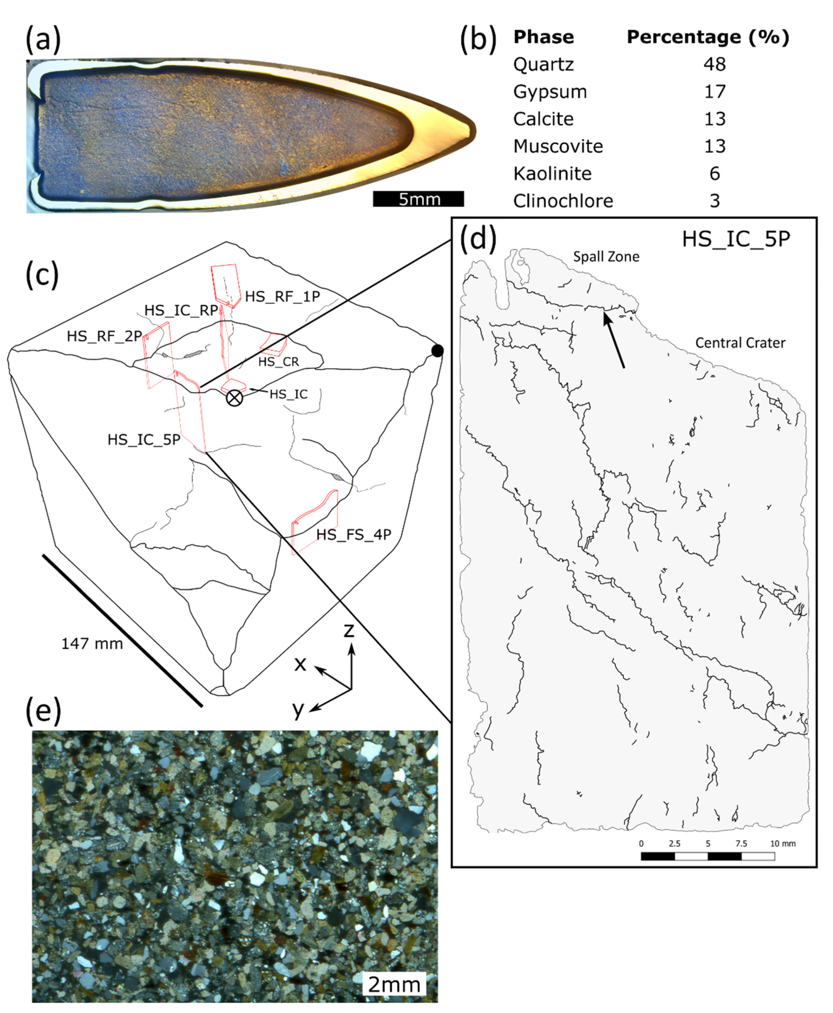
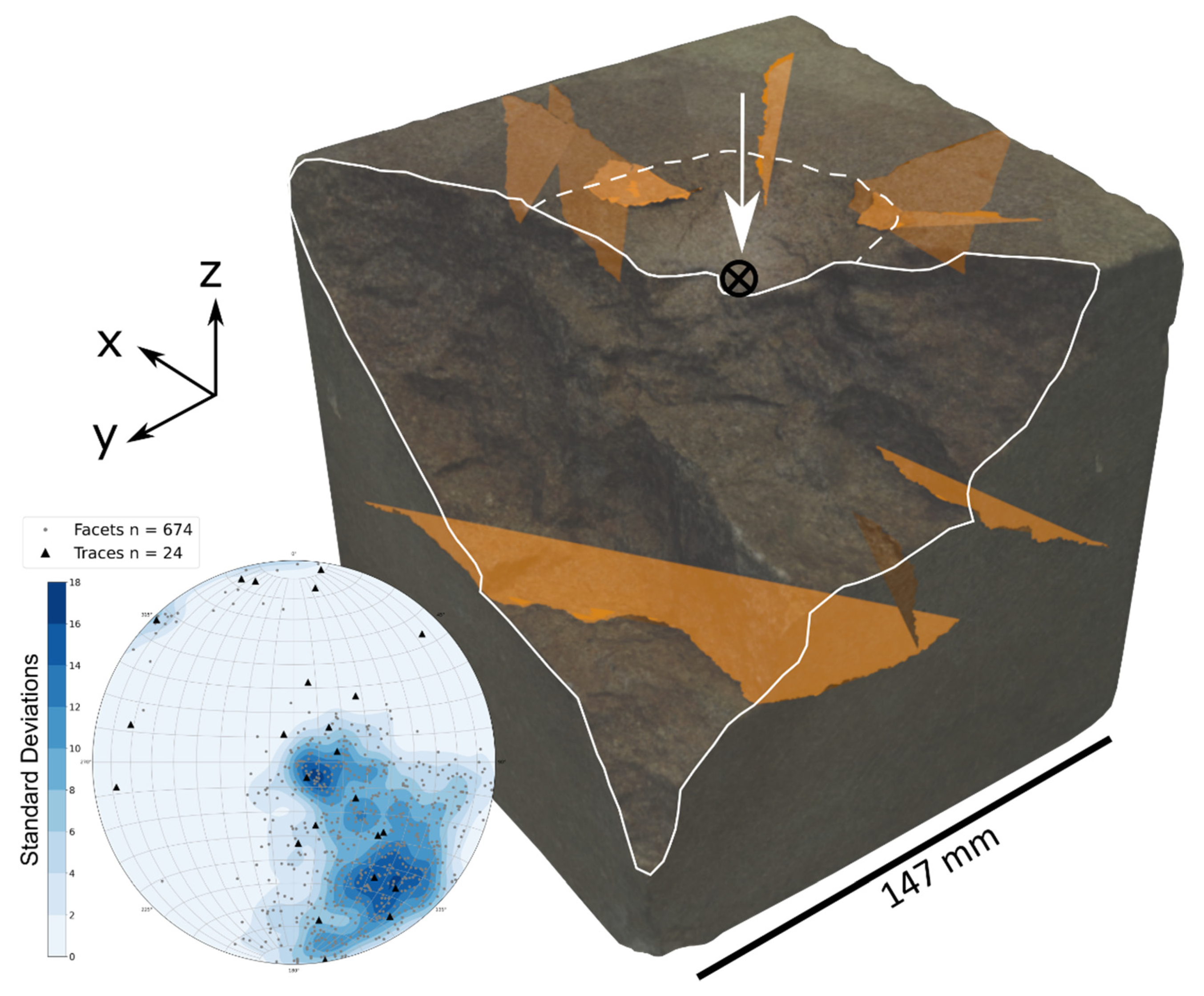
2.2. Characterising Damage Morphology
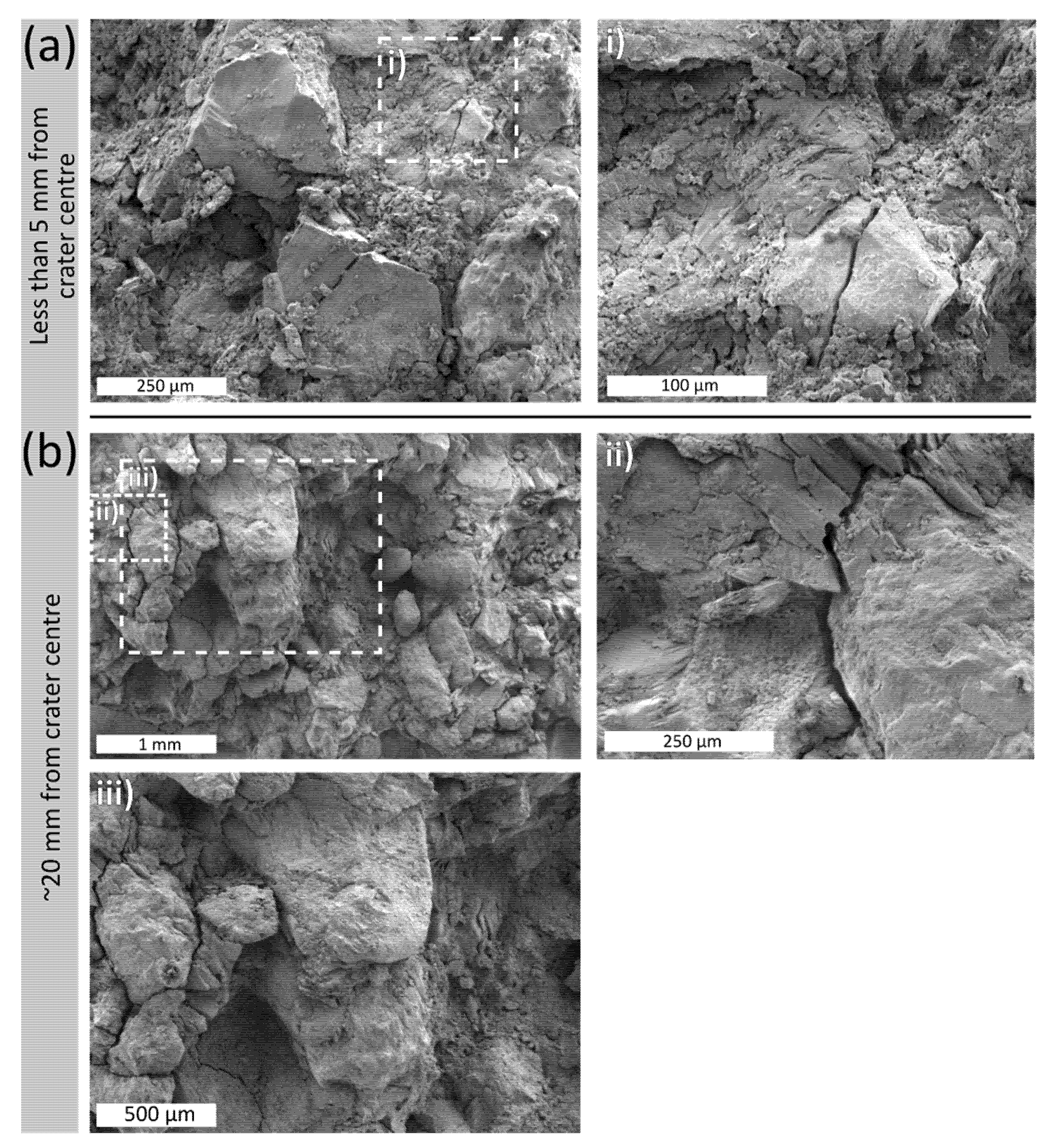
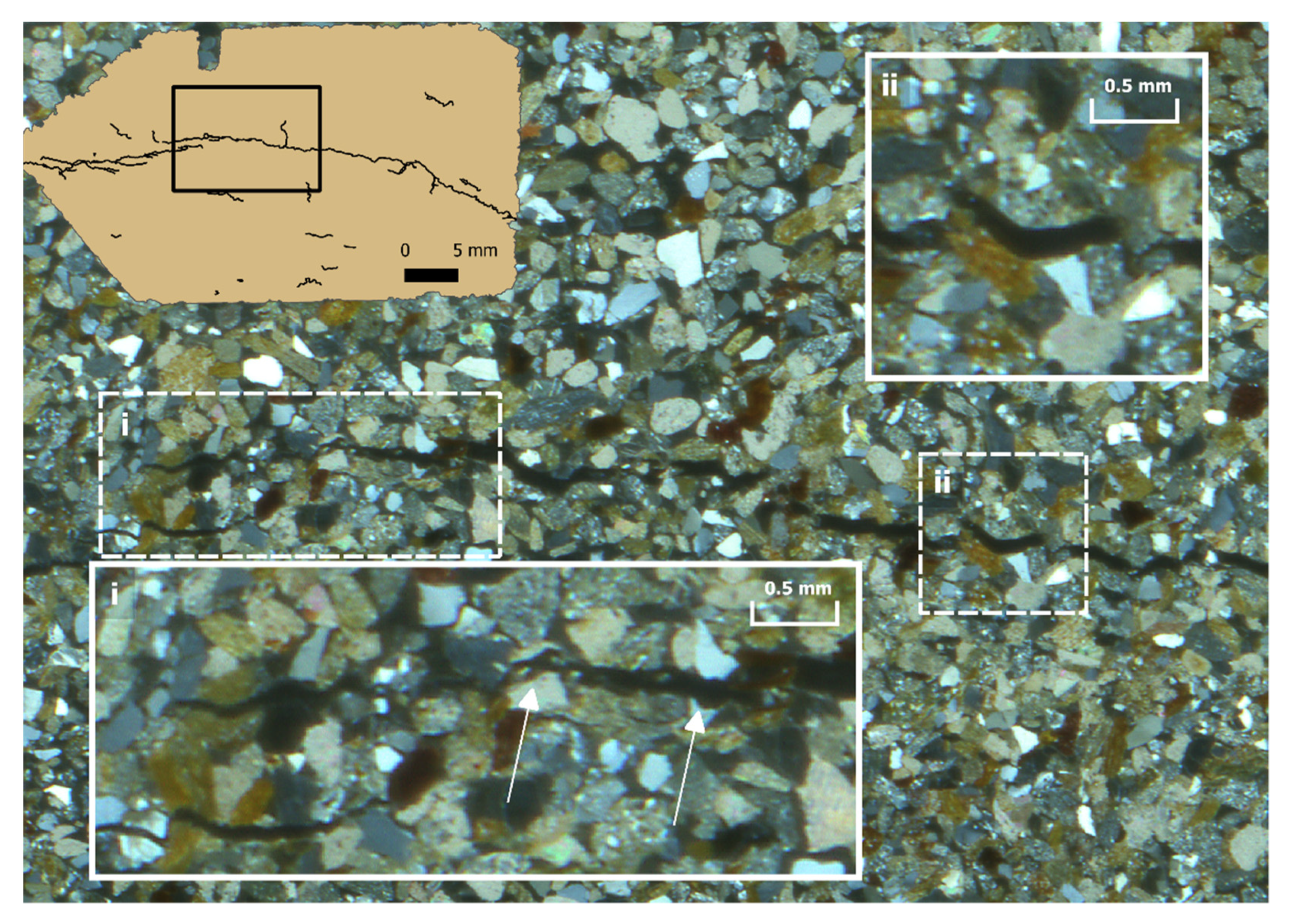
2.3. Microscale Analysis
3. Results
4. Discussion
5. Conclusions
Supplementary Materials
Author Contributions
Funding
Data Availability Statement
Acknowledgments
Conflicts of Interest
Appendix A

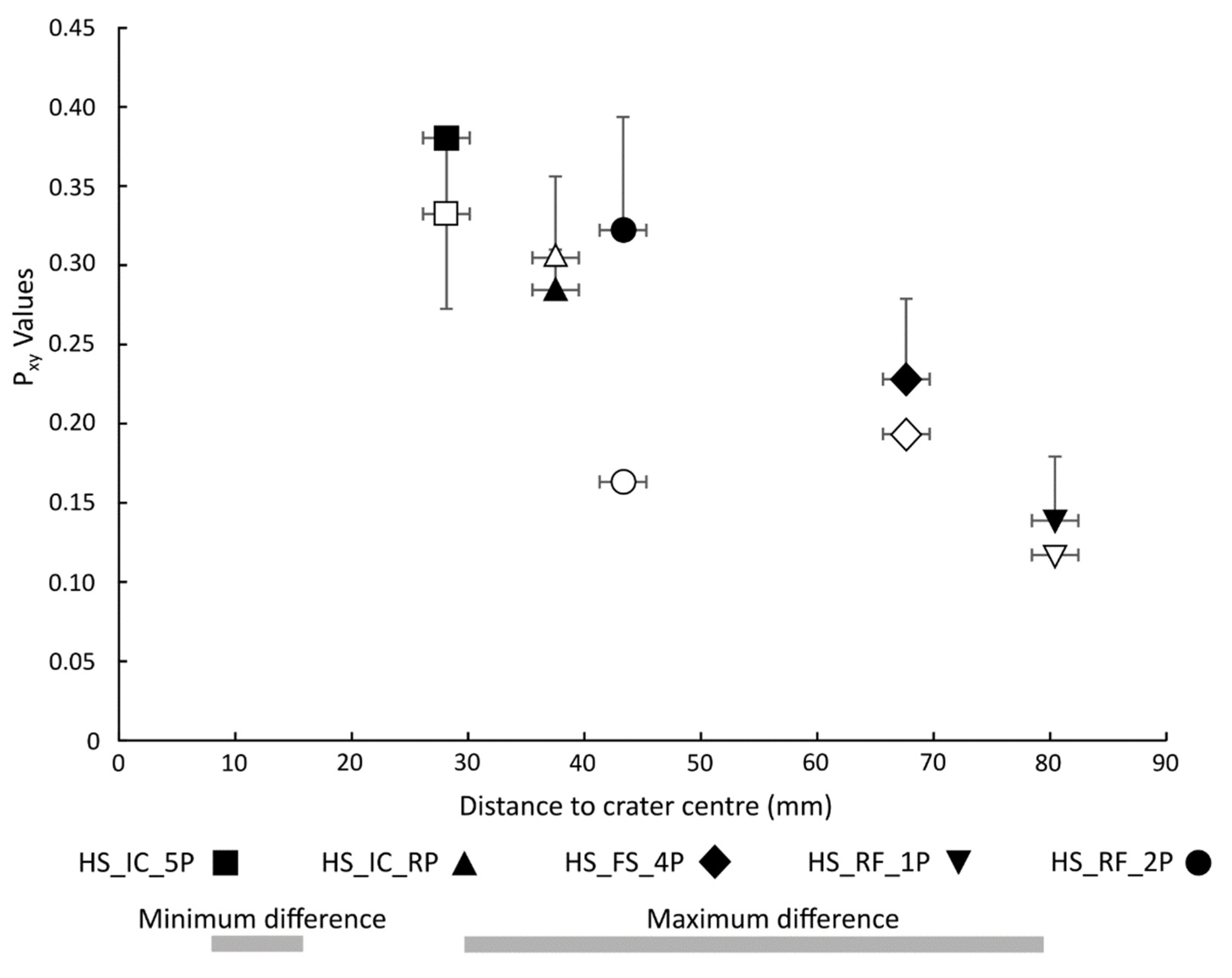
| Sample | dmin (mm) | d (mm) | dmax (mm) | Lc (mm) | P21 (mm−1) | P22 | P32 (mm−1) | |||
|---|---|---|---|---|---|---|---|---|---|---|
| HS_IC_5P | 16 | 28 | 49 | 1.146 | +0.016 | 0.332 | +0.001 | 0.380 | +0.001 | - |
| −0.314 | −0.005 | −0.108 | ||||||||
| HS_IC_RP | 29 | 38 | 49 | 0.933 | +0.006 | 0.305 | +0.005 | 0.284 | +0.003 | - |
| −0.246 | −0.005 | −0.072 | ||||||||
| HS_FS_4P | 57 | 68 | 79 | 1.178 | +0.023 | 0.193 | +0.003 | 0.232 | +0.004 | - |
| −0.274 | −0.002 | −0.051 | ||||||||
| HS_RF_1P | 50 | 80 | 100 | 1.185 | - | 0.117 | +0.001 | 0.134 | - | - |
| −0.353 | −0.001 | −0.040 | ||||||||
| HS_RF_2P | 46 | 43 | 54 | 1.975 | +0.010 | 0.163 | - | 0.322 | - | - |
| −0.408 | −0.003 | −0.071 | ||||||||
| Full block | - | - | - | - | - | - | - | - | - | 0.101 |
References
- Stone, P.G. The Challenge of Protecting Heritage in Times of Armed Conflict. Mus. Int. 2018, 67, 40–54. [Google Scholar] [CrossRef]
- Isakhan, B.; Zarandona, J.A.G. Layers of religious and political iconoclasm under the Islamic State: Symbolic sectarianism and pre-monotheistic iconoclasm. Int. J. Herit. Stud. 2018, 24, 1–16. [Google Scholar] [CrossRef]
- Pollock, S. Archaeology and Contemporary Warfare. Annu. Rev. Anthropol. 2016, 45, 215–231. [Google Scholar] [CrossRef] [Green Version]
- Mol, L.; Gomez-Heras, M.; Brassey, C.; Green, O.; Blenkinsop, T. The benefit of a tough skin: Bullet holes, weathering and the preservation of heritage. R. Soc. Open Sci. 2017, 4, 160335. [Google Scholar] [CrossRef] [Green Version]
- Mol, L.; Gomez-Heras, M. Bullet impacts and built heritage damage 1640–1939. Herit. Sci. 2018, 6, 35. [Google Scholar] [CrossRef]
- Gilbert, O.; Mol, L.; Campbell, O.; Blenkinsop, T. The influence of angle of ballistic impact on stone weathering. In Proceedings of the 14th International Congress on the Deterioration and Conservation of Stone, Göttingen, Germany, 7–12 September 2020; pp. 309–313. [Google Scholar]
- Gilbert, O.; Mol, L.; Campbell, O.; Blenkinsop, T. Permeability and Surface Hardness Surveying of Stone Damaged by Ballistic Impact. Heritage 2019, 2, 1369–1389. [Google Scholar] [CrossRef] [Green Version]
- Goudie, A.; Viles, H.A. Salt Weathering Hazard; Wiley: Hoboken, NJ, USA, 1997. [Google Scholar]
- Mol, L.; Viles, H.A. The role of rock surface hardness and internal moisture in tafoni development in sandstone. Earth Surf. Process. Landf. 2012, 37, 301–314. [Google Scholar] [CrossRef]
- Navarre-Sitchler, A.; Brantley, S.L.; Rother, G. How Porosity Increases During Incipient Weathering of Crystalline Silicate Rocks. Rev. Mineral. Geochem. 2015, 80, 331–354. [Google Scholar] [CrossRef] [Green Version]
- Scherer, G.W. Stress from crystallization of salt. Cem. Concr. Res. 2004, 34, 1613–1624. [Google Scholar] [CrossRef]
- Lebedeva, M.I.; Brantley, S.L. Weathering and erosion of fractured bedrock systems. Earth Surf. Process. Landf. 2017, 42, 2090–2108. [Google Scholar] [CrossRef] [Green Version]
- Pope, G.A.; Meierding, T.C.; Paradise, T.R. Geomorphology’s role in the study of weathering of cultural stone. Geomorphology 2002, 47, 211–225. [Google Scholar] [CrossRef]
- Allen, C.D.; Ester, S.; Groom, K.M.; Schubert, R.; Hagele, C.; Olof, D.; James, M. A geologic assessment of historic saint elizabeth of hungary church using the cultural stone stability index, Denver, Colorado. In Urban Geomorphology: Landforms and Processes in Cities; Elsevier: Amsterdam, The Netherlands, 2018; pp. 277–302. [Google Scholar] [CrossRef]
- Jo, Y.H.; Lee, C.H. Making Method of Deterioration Map and Evaluation Techniques of Surface and Three-dimensional Deterioration Rate for Stone Cultural Heritage. J. Conserv. Sci. 2011, 27, 251–260. [Google Scholar]
- Hatır, M.E.; İnce, İ.; Korkanç, M. Intelligent detection of deterioration in cultural stone heritage. J. Build. Eng. 2021, 44, 102690. [Google Scholar] [CrossRef]
- Moropoulou, A.; Labropoulos, K.C.; Delegou, E.T.; Karoglou, M.; Bakolas, A. Non-destructive techniques as a tool for the protection of built cultural heritage. Constr. Build. Mater. 2013, 48, 1222–1239. [Google Scholar] [CrossRef]
- Lange, M.A.; Ahrens, T.J.; Boslough, M.B. Impact cratering and spall failure of gabbro. Icarus 1984, 58, 383–395. [Google Scholar] [CrossRef] [Green Version]
- Polanskey, C.A.; Ahrens, T.J. Impact Spallation Experiments- Fracture Patterns and Spall Velocities. Icarus 1990, 87, 140–155. [Google Scholar] [CrossRef]
- Buhl, E.; Poelchau, M.H.; Dresen, G.; Kenkmann, T. Deformation of dry and wet sandstone targets during hypervelocity impact experiments, as revealed from the MEMIN Program. Meteorit. Planet. Sci. 2013, 48, 71–86. [Google Scholar] [CrossRef]
- Børvik, T.; Dey, S.; Clausen, A.H. Perforation resistance of five different high-strength steel plates subjected to small-arms projectiles. Int. J. Impact Eng. 2009, 36, 948–964. [Google Scholar] [CrossRef]
- Børvik, T.; Olovsson, L.; Dey, S.; Langseth, M. Normal and oblique impact of small arms bullets on AA6082-T4 aluminium protective plates. Int. J. Impact Eng. 2011, 38, 577–589. [Google Scholar] [CrossRef]
- Sancho, C.; Fort, R.; Belmonte, A. Weathering rates of historic sandstone structures in semiarid environments (Ebro basin, NE Spain). Catena 2003, 53, 53–64. [Google Scholar] [CrossRef]
- Franchi, R.; Savelli, D.; Colosi, F.; Drapp, P.; Gabrielli, R.; Moretti, E.; Peloso, D. Petra and Beida (Jordan): Two adjacent archaeological sites up to an exploitation of geomorphology-related topics for a cultural and touristic development Petra e Beida (Giordania): Due siti archeologici confinanti idonei per una valorizzazione di temi. Mem. Descr. Cart. Geol. D’It. 2009, 88, 77–90. [Google Scholar]
- Mol, L.; Green, O. Shot to pieces and shocked to the core. Infocus Mag. 2015, 30–40. [Google Scholar] [CrossRef]
- Jancosek, M.; Pajdla, T. Multi-view reconstruction preserving weakly-supported surfaces. In Proceedings of the Conference on Computer Vision and Pattern Recognition 2011, Colorado Springs, CO, USA, 20–25 June 2011; pp. 3121–3128. [Google Scholar] [CrossRef]
- Moulon, P.; Monasse, P.; Marlet, R. Adaptive Structure from Motion with a Contrario Model Estimation. In Computer Vision–ACCV 2012; Springer: Berlin/Heidelberg, Germany, 2012; pp. 257–270. [Google Scholar] [CrossRef] [Green Version]
- CloudCompare (Version 2.11.3). 2020. Available online: http://www.cloudcompare.org/ (accessed on 5 February 2021).
- Dewez, T.J.B.; Girardeau-Montaut, D.; Allanic, C.; Rohmer, J. Facets: A cloudcompare plugin to extract geological planes from unstructured 3d point clouds. Int. Arch. Photogramm. Remote Sens. Spat. Inf. Sci. 2016, 41, 799–804. [Google Scholar] [CrossRef] [Green Version]
- Thiele, S.T.; Grose, L.; Samsu, A.; Micklethwaite, S.; Vollgger, S.A.; Cruden, A.R. Rapid, semi-automatic fracture and contact mapping for point clouds, images and geophysical data. Solid Earth 2017, 8, 1241–1253. [Google Scholar] [CrossRef] [Green Version]
- Blender(Version 2.92.0). 2020. Available online: https://www.blender.org/ (accessed on 30 March 2021).
- Cignoni, P.; Callieri, M.; Corsini, M.; Dellepiane, M.; Ganovelli, F.; Ranzuglia, G. MeshLab: An Open-Source Mesh Processing Tool. In Eurographics Italian Chapter Conference; The Eurographics Association: Norrköping, Sweden, 2008; pp. 129–136. [Google Scholar] [CrossRef]
- Ranzuglia, G.; Callieri, M.; Dellepiane, M.; Cignoni, P.; Scopigno, R. MeshLab as a complete tool for the integration of photos and color with high resolution 3D geometry data. In CAA 2012 Conference Proceedings; Amsterdam University Press: Amsterdam, The Netherlands, 2013; pp. 406–416. [Google Scholar]
- Kamb, W.B. Ice petrofabric observations from Blue Glacier, Washington, in relation to theory and experiment. J. Geophys. Res. 1959, 64, 1891–1909. [Google Scholar] [CrossRef]
- Vollmer, F.W. C program for automatic contouring of spherical orientation data using a modified Kamb method. Comput. Geosci. 1995, 21, 31–49. [Google Scholar] [CrossRef]
- Tikoff, B.; Chatzaras, V.; Newman, J.; Roberts, N.M. Big data in microstructure analysis: Building a universal orientation system for thin sections. J. Struct. Geol. 2019, 125, 226–234. [Google Scholar] [CrossRef]
- Sanderson, D.J.; Nixon, C.W. The use of topology in fracture network characterization. J. Struct. Geol. 2015, 72, 55–66. [Google Scholar] [CrossRef]
- Andrews, B.; Roberts, J.J.; Shipton, Z.K.; Bigi, S.; Tartarello, M.C.; Johnson, G. How do we see fractures? Quantifying subjective bias in fracture data collection. Solid Earth 2019, 10, 487–516. [Google Scholar] [CrossRef] [Green Version]
- Nyberg, B.; Nixon, C.W.; Sanderson, D.J. NetworkGT: A GIS tool for geometric and topological analysis of two-dimensional fracture networks. Geosphere 2018, 14, 1618–1634. [Google Scholar] [CrossRef] [Green Version]
- Dershowitz, W.S.; Einstein, H.H. Characterizing rock joint geometry with joint system models. Rock Mech. Rock Eng. 1988, 21, 21–51. [Google Scholar] [CrossRef]
- Dershowitz, W.S.; Herda, H.H. Interpretation of fracture spacing and intensity. In Proceedings of the 33rd U.S. Symposium on Rock Mechanics (USRMS), Santa Fe, NM, USA, 3–5 June 1992. [Google Scholar]
- Mol, L. Armed conflict impacts on the microscale. J. Phys. Conf. Ser. 2017, 902, 012032. [Google Scholar] [CrossRef]
- Kumar, P.S. Structural effects of meteorite impact on basalt: Evidence from Lonar crater, India. J. Geophys. Res. Solid Earth 2005, 110, B12. [Google Scholar] [CrossRef] [Green Version]
- Buhl, E.; Kowitz, A.; Elbeshausen, D.; Sommer, F.; Dresen, G.; Poelchau, M.H.; Reimold, W.U.; Schmitt, R.T.; Kenkmann, T. Particle size distribution and strain rate attenuation in hypervelocity impact and shock recovery experiments. J. Struct. Geol. 2013, 56, 20–33. [Google Scholar] [CrossRef]
- Ravi-Chandar, K. Dynamic fracture of nominally brittle materials. Int. J. Fract. 1998, 90, 83–102. [Google Scholar] [CrossRef]
- Lawn, B.R. Fracture of Brittle Solids; Cambridge University Press: Cambridge, UK, 1993. [Google Scholar] [CrossRef]
- Buhl, E.; Sommer, F.; Poelchau, M.H.; Dresen, G.; Kenkmann, T. Ejecta from experimental impact craters: Particle size distribution and fragmentation energy. Icarus 2014, 237, 131–142. [Google Scholar] [CrossRef]
- Theoulakis, P.; Moropoulou, A. Microstructural and mechanical parameters determining the susceptibility of porous building stones to salt decay. Constr. Build. Mater. 1997, 11, 65–71. [Google Scholar] [CrossRef]
- McCabe, S.; Smith, B.J.; Warke, P.A. Exploitation of inherited weakness in fire-damaged building sandstone: The ‘fatiguing’ of ‘shocked’ stone. Eng. Geol. 2010, 115, 217–225. [Google Scholar] [CrossRef]
- Fernández-Hernandez, J.; González-Aguilera, D.; Rodríguez-Gonzálvez, P.; Mancera-Taboada, J. Image-Based Modelling from Unmanned Aerial Vehicle (UAV) Photogrammetry: An Effective, Low-Cost Tool for Archaeological Applications. Archaeometry 2015, 57, 128–145. [Google Scholar] [CrossRef]
- Tolch, N.A.; Bushkovitch, A.V. Penetration and Crater Volume in Various Kinds of Rocks as Dependent on Caliber, Mass, and Striking Velocity of Projectile; Defence Technical Information Center: Fort Belvoir, VA, USA, 1947.
- Poelchau, M.H.; Kenkmann, T.; Thoma, K.; Hoerth, T.; Dufresne, A.; Schafer, F. The MEMIN research unit: Scaling impact cratering experiments in porous sandstones. Meteorit. Planet. Sci. 2013, 48, 8–22. [Google Scholar] [CrossRef]
- Pierazzo, E.; Melosh, H.J. Understanding oblique impacts from experiments, observations, and modelling. Annu. Rev. Earth Planet. Sci. 2000, 28, 141–167. [Google Scholar] [CrossRef] [PubMed]


| Region | Area (mm2) |
|---|---|
External of damaged block includes:
| 122,510 |
| 2520 | |
| 17,850 | |
| Internal fractures (min. estimate) | 10,470 |
| Total surface area (min. estimate) | 132,980 |
Publisher’s Note: MDPI stays neutral with regard to jurisdictional claims in published maps and institutional affiliations. |
© 2021 by the authors. Licensee MDPI, Basel, Switzerland. This article is an open access article distributed under the terms and conditions of the Creative Commons Attribution (CC BY) license (https://creativecommons.org/licenses/by/4.0/).
Share and Cite
Campbell, O.; Blenkinsop, T.; Gilbert, O.; Mol, L. Surface and Subsurface Damage Caused by Bullet Impacts into Sandstone. Geosciences 2021, 11, 395. https://doi.org/10.3390/geosciences11090395
Campbell O, Blenkinsop T, Gilbert O, Mol L. Surface and Subsurface Damage Caused by Bullet Impacts into Sandstone. Geosciences. 2021; 11(9):395. https://doi.org/10.3390/geosciences11090395
Chicago/Turabian StyleCampbell, Oliver, Tom Blenkinsop, Oscar Gilbert, and Lisa Mol. 2021. "Surface and Subsurface Damage Caused by Bullet Impacts into Sandstone" Geosciences 11, no. 9: 395. https://doi.org/10.3390/geosciences11090395
APA StyleCampbell, O., Blenkinsop, T., Gilbert, O., & Mol, L. (2021). Surface and Subsurface Damage Caused by Bullet Impacts into Sandstone. Geosciences, 11(9), 395. https://doi.org/10.3390/geosciences11090395