Article

Dating of Holocene Sedimentary and Paleosol Sequence within the Guadalentín Depression (Murcia, SE Spain): Paleoclimatic Implications and Paleoseismic Signals

1
Departamento Geología, Escuela Politécnica Superior de Ávila, Universidad de Salamanca, 05003 Ávila, Spain
2
Departamento Edafología, Escuela Técnica Superior de Ingenieros Agrónomos, Universidad Politécnica de Madrid, 28040 Madrid, Spain
3
Centro Nacional de Investigación sobre la Evolución Humana (CENIEH), Paseo Sierra de Atapuerca 3, 09002 Burgos, Spain
4
Departamento Geología, Geografía y Medio Ambiente, Universidad de Alcalá, 28802 Alcalá de Henares, Spain
5
Departamento Geología, Facultad de Ciencias, Universidad de Salamanca, 37008 Salamanca, Spain
6
Instituto Geológico y Minero de España (IGME-CSIC), 28003 Madrid, Spain
*
Author to whom correspondence should be addressed.
Geosciences 2022, 12(12), 459; https://doi.org/10.3390/geosciences12120459
Submission received: 8 August 2022 / Revised: 21 November 2022 / Accepted: 13 December 2022 / Published: 19 December 2022
(This article belongs to the Special Issue Quaternary Sedimentary Successions II)

Abstract

:
This work presents the chronology of the Holocene filling of the Guadalentín Tectonic Depression (Murcia, SE Spain) combining 14C and OSL age data. This work studies the sediments and paleosols interbedded in the sedimentary sequence between Totana and Librilla, using as reference the Espuña Karting section (Alhama de Murcia), which has been fully sampled for its geochronological analysis. The entire dated sequences record the last c. 20–19 ka BP, although local basal travertine beds extend back to the Late Pleistocene (30–33 ka). Soil morphology and properties from dated paleosols record different environmental crises in SE Spain, but also a progressive aridification throughout the Holocene. The Chalcolithic Paleosol develops soon after c. 4.6–4.0 BP, nearly coinciding with the start of the Meghalayan stage, evidencing a drastic change from relatively humid to arid conditions, coincident with the crisis of the Copper Age civilizations in Spain. The Bronze Age paleosol also developed under arid but relatively more humid conditions, indicating a more important and longer gap in the sedimentary sequence soon after c. 2.5–2.7 ka BP. This stop in the sedimentation are correlative to the first stages of fluvial incision at basin center locations and the desiccation and fragmentation of the ancient wetlands coinciding with the collapse of the Bronze Age civilizations in SE Spain (Argaric Culture). During the Ibero-Roman Humid Period (IRHP), c. 2.6–1.6 ka BP, the last pedogenic cycle occurred under relatively humid conditions. This preluded the progressive establishment of exorheic fluvial environments as well as a period of paleoseismic activity in the area around 2.0–1.8 ka BP.

1. Introduction

This study focuses on the analysis of the Holocene sedimentary sequence filling the Guadalentín Tectonic Depression [1,2,3] in the semiarid SE Spain (Murcia Region; Figure 1). The study is comprised of a detailed analysis of the Holocene sedimentary and paleosol sequence for its complete geochronological analysis in a single selected outcrop at basin center locations. After the field examination, we chose the “Karting Espuña” section near Alhama de Murcia, in the left margin of the Guadalentín rambla-valley (with the star in Figure 1) for an intensive sampling for sedimentology, soil properties, OSL and 14C dating (Figure 2). Previous studies provide a good set of geochronological radiocarbon data [3,4,5,6,7,8], but they are disseminated in different isolated outcrops within the basin (black stars in Figure 1). This dataset allowed for the construction of both: (1) a synthetic sedimentary sequence for the Late Holocene sedimentary infilling of the basin and (2) the proposal of a standard chronology for the prehistoric and historic units featuring that sequence [6]. However, to date, no geochronological study has been carried out on a single outcrop, with a nearly continuous record of the historical and prehistoric sedimentary units featuring the area for the last c. 6000 years BP. The final target is to reconstruct the Late Holocene paleoenvironmental evolution of the basin based on a more robust geochronological framework exploring preliminary relationships among soil development, environmental crises, historic/prehistoric depopulation processes and paleoseismic records.

2. Geological and Geomorphological Frameworks

The study area is located in the central sector of the Guadalentín Depression (Murcia, SE) between the localities of Totana and Librilla (Spain; Figure 1). The Guadalentín Depression is the most outstanding landscape feature of tectonic origin within the “so called” central segment of the Eastern Betic Shear Zone (EBSZ) [1]. This tectonic depression is bounded by the NE-SW sinistral strike-slip faults of Lorca-Alhama de Murcia (LAF) to the West and by the Palomares (PLF), North-Carrascoy (NCF) and El Romeral (ERF) faults to the East (Figure 1). The Pleistocene sedimentary history of this depression was controlled by tectonically to climatically driven alluvial fan sedimentation evolving in a pure-endorheic environment [2,3]. The late Pleistocene lacustrine environments are dated from around the isotopic stage MIS 3 (c. 30–33 ka) with the formation of travertine-like deposits [4] at basin center locations (point 6 in Figure 1). The Holocene sedimentary sequence evolved in more semiarid conditions controlled by distal fan aggradation converging towards basin center palustrine and playa-lake systems [2,3,5].
Existing data indicate that endorheic conditions occurred within the depression until at least the Bronze Age (c. 3.2 ka), but semi-endorheic conditions prevailed during a prolonged period up to Roman and even Muslim times (c. 2–1 ka) [5,6]. In fact, the present exorheic pattern of the zone was only completed by artificial drainage works during the last millennium [6]. According to the published data [2,3,4,5,6], the Late Holocene sedimentary filling was controlled by the progressive distal progradation and incision of alluvial fan channels towards basin center. This also involved the distal incision throughout the large fan generated by the present Guadalentín River, which controlled the preliminary axial incision and dissection of the basin (Figure 1). This primary incision within the basin was mainly caused by a long-lasted period of climatic aridification, eventually resulting in the fragmentation of the extensive wetlands and salt marshes previously existing in the area, which promoted the eventual collapse of the Bronze Age populations in the area between c. 2700 and 2500 BP [5,7,8,9]. This process, driven by intra-basinal erosion, was mainly caused by the intrinsic behavior of alluvial fan channels under conditions of progressive distal limited aggradation (sense Adrian M. Harvey) [6,10]. However, from that time on, headward erosion from the ancient Sangonera and Las Moreras rambla systems contributed to the desiccation and dissection of the ancient wetlands in the Librilla–Totana zone (Figure 1). Therefore, from the Late Bronze Age fluvial evolution was basically forced by the competition of progressive distal fan aggradation and progradation on palustrine environments and the headward erosion of the Sangonera and Las Moreras rambla systems, which eventually captured the ancient Guadalentín fan channel (Figure 1) [6]. These competitive processes promoted the fluvial transfiguration of the area and the fragmentation of the previous Holocene wetlands, whose sedimentary record (object of this study) is fragmentarily preserved in disconnected isolated outcrops across the studied area [9].
Despite these environmental influences, several channeling works during the last millennia (post-Roman, Muslim and modern times) allowed for the present exorheic conditions with the artificial connection of the ancient Guadalentín and Sangonera streams with the Segura River [4,6,9]. In spite of these artificial channeling works, the area has partially preserved its ancient semi-endorheic behavior until present times, subject to frequent flash floods caused by the torrential overflow of the watercourses (ramblas). On the other hand, the ancient palustrine area is fragmented in several salt marshes and salt flats of playa-lake type, preserved until the mid-20th century, but currently working as crypto-wetlands subject to rapid flash-flooding events [11].
The studied sedimentary sequence covers from the basal Late Pleistocene materials to upper Neolithic, Chalcolithic and Bronze Age levels, which are buried by medieval to present flood and overbank deposits. Figure 2 illustrates the sequential sampling performed in the studied vertical section, indicating the theoretical correspondence among the outcropping units and the regionally recognized historic and prehistoric units. The sedimentary units are separated by prominent paleosols and/or erosive lags (Figure 2), as it occurs all over the basin. According to chronological evidence, the observed paleosols would correspond to those developed at the top of the Bronze and Roman levels in other zones of the basin [5,7,12,13].
Our study provides a coherent geochronological framework for the Holocene filling of the depression in a single sequence, presenting a set of new radiocarbon (14C) and Optically Stimulated Luminescence (OSL) dates. However, the complete understanding of the Late Holocene environmental evolution of the basin requires the incorporation of complementary sedimentary, soil or geochronological data previously compiled in other key outcrops within the basin (Figure 1). The obtained results are compared with the Quaternary paleoclimatic analogues existing in the area [14,15], allowing for the comparison of paleosol-sedimentary episodes within the basin (points 1 to 8 in Figure 1) with geochronological data from the adjacent dissected Lorca and Librilla Neogene basins (points 9 and 10 in Figure 1) [5,16]. Eventually, the obtained results will be compared with the geochronology of paleoseismic [12,17] and archaeoseismic [18] data existing in the zone (points 11 and 12 in Figure 1) to explore probable relationships among paleoenvironmental crises, paleoseismic records and their affection to the different archaeological sites in the zone.

3. Materials and Methods

The Karting Espuña section displays a nearly complete sedimentary sequence for the Holocene fill of the Guadalentín Depression. This section has been systematically analyzed for sedimentology, paleosol and geochronological analysis for this study. The vertically stacked sequence was sampled for OSL and radiocarbon dating (14C) (Figure 2). For descriptive and comparison purposes, we selected three other important sequences studied within the basin with relevant geochronological and paleosol-derived paleoenvironmental information, such as La Alcanara, Ventas del Rio, Librilla and El Romeral (points 3, 4, 7 and 8 in Figure 1, respectively). The analysis of the sedimentary sequence is completed with sedimentological, soil and geochronological data for the most ancient outcrops within the basin of Late Pleistocene age [4] at the Puente Nuevo section (Point 6 Figure 1; Table 1).

3.1. Radiocarbon Dating (14C)

Radiocarbon dating was done by the commercial services of Beta Analytics Ltd. (Dublin, Ireland) following the radiometric and calibration protocols of this company in the year 2018 (BetaCal 3.21) based on Bayesian analysis [19] and INTCAL 13 databases [20]. Measurements were made in charred materials (e.g., charcoal fragments) and terrestrial gastropods embedded in the analyzed paleosols and closely related to the five samples for OSL dating collected in this section (Figure 2). Only radiocarbon samples CR1 and CR4 were collected from adjacent outcrops located 50–100 m away from the studied section; their relative position is shown in Figure 2. Additionally, two more radiocarbon dates were obtained for the basal travertine deposits of the sedimentary filling of the basin outcropping at the Puente Nuevo section (PTN0 and PTN1; Point 6 Figure 1), South of Librilla, preliminary reported by Calmel-Ávila et al. [4]. Obtained dates were complemented and compared with existing radiocarbon measurements in the central sector of the Depression obtained at La Alcanara, Ventas del Rio and Librilla and El Romeral Sections [5,6] (Table 1), as well as with the set of about 20 radiocarbon ages obtained for paleoseismological analyses in the zone [13,17,21].
Figure 1 displays the location of all the mentioned sections with radiocarbon data and ages, and the more important ones are summarized in Table 1.

3.2. Optically Stimulated Luminescence Dating (OSL)

The five samples collected for OSL dating are all located in the vertically stacked sequence of the Karting Espuña profile (Figure 3) giving us the possibility to obtain a sequence of numerical ages for most of the sedimentary units filling the Guadalentín Depression for the first time in one single section. OSL analyses was carried out at the Radioisotopes Unit (RDI-CITIUS) of the University of Sevilla in Spain following standard procedures in luminescence dating described in Aitken [22]. The dose rates (Gy/ka) are based on the average radionuclide activity concentrations measured using high-resolution gamma spectrometry on bulk material from each sample. Conversion factors from Guerin et al. [23] were used to derive the dose rates. The age calculation is based on the relation:
A g e   ( k a ) = E q u i v a l e n t   d o s e   ( G y ) D o s e   r a t e   ( G y / k a )
A ± 4% was added to measured water content in the studied samples to account for variation during the burial time. The contribution of cosmic radiation to the total dose rate was calculated as a function of latitude, altitude, burial depth and average over-burden density based on data by Prescott and Hutton [24]. Final dose rate values were calculated using DRAC calculator [25].
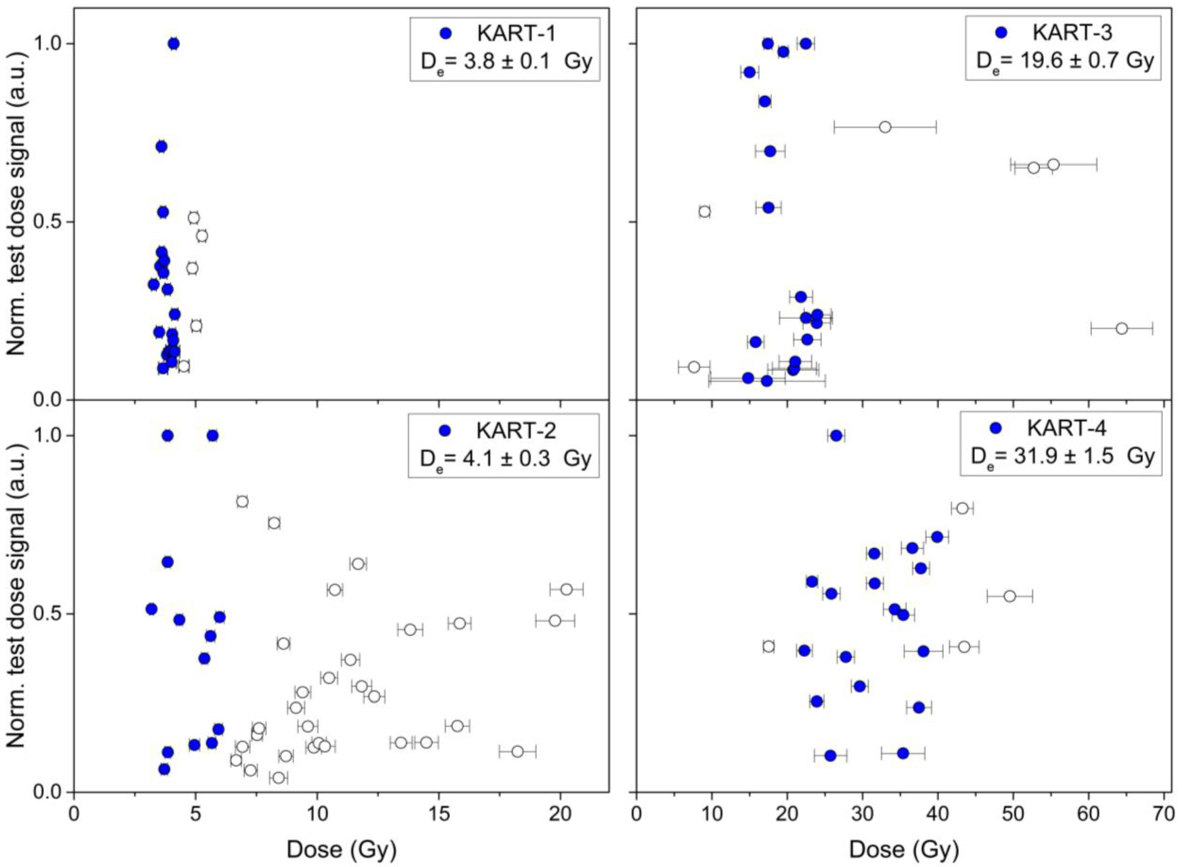
Equivalent doses (Gy) were estimated from the OSL response of quartz grains (180–250 μm size) extracted from each sample. In total, 30–50 multigrain aliquots (~30 grains per aliquot) of each sample were measured to obtain representative dose distributions (Figure 3). All samples were measured using a SAR blue OSL protocol [26]. OSL response of sample KART-5 was not reproducible, and therefore, estimating an equivalent dose was not possible. In this case, the resulting fraction after the chemical and physical processes used to extract quartz grains did not show the same properties as crystalline quartz. It was therefore not possible to estimate a De values and the corresponding age. Only radionuclide concentration and derived environmental dose rate is reported for the KART-5 sample (Table 2).
Dose distributions of samples KART-1, KART-3 and KART-4 are normally distributed, characterized by overdispersion values <20%. For these three samples, the Central Age Model (CAM) [27] was applied on the reduced distributions, excluding outliers identified as those values outside 1.5 times the interquartile range (Figure 3). In contrast, dose distribution of sample KART-2 has an overdispersion of 60%, suggesting that it might be affected by incomplete bleaching, i.e., the exposure to daylight prior to deposition was insufficient to reset the luminescence signal. This derives in grains with previously accumulated doses, and therefore, larger than the true burial dose contributing to the measured population. In this case, the Internal–External Unity (IEU) criteria [28] was applied to base the equivalent dose estimation on the part of the dose distribution that was the most likely to be well-bleached. The incomplete bleaching is probably due to the torrential nature of the deposits inducing an important intrasedimentary rapid reworking during flash-flood events typical of the zone from Holocene to historical times [7,8,29]. The expected quick erosion and transport of previously deposited detritic materials probably prevented the proper bleaching of quartz grains producing anomalous or inherited burial OSL ages, as observed in geochronological studies in the zone [30].

3.3. Analysis of Paleosols

The study of the sedimentary sequence, together with a morphologic description of paleosols and the corresponding soil horizons, was carried out in the field according to FAO [31] and Soil Survey Staff [32] nomenclature. The following standards were used for the description of soil horizons: (1) Bw horizons reflect some structure development and/or accumulation of soils elements (clay, carbonate, etc.) linked to bleaching processes; (2) Bk horizons indicate accumulation of pedogenic carbonate in previously B lime-free clayey horizons; (3) Ck represents both limited carbonate accumulations and/or inherited calcareous sediments; (4) Cy horizons represent the accumulation of significant secondary gypsums and also, in our case, scattered crystals of halite. Our study did not identify typical Bt horizons, where pedogenic clay enrichment typically results in well-developed to blocky or prismatic soil structures [32]. In our case, the important content of carbonate and secondary gypsum precludes the required clay illuviation.
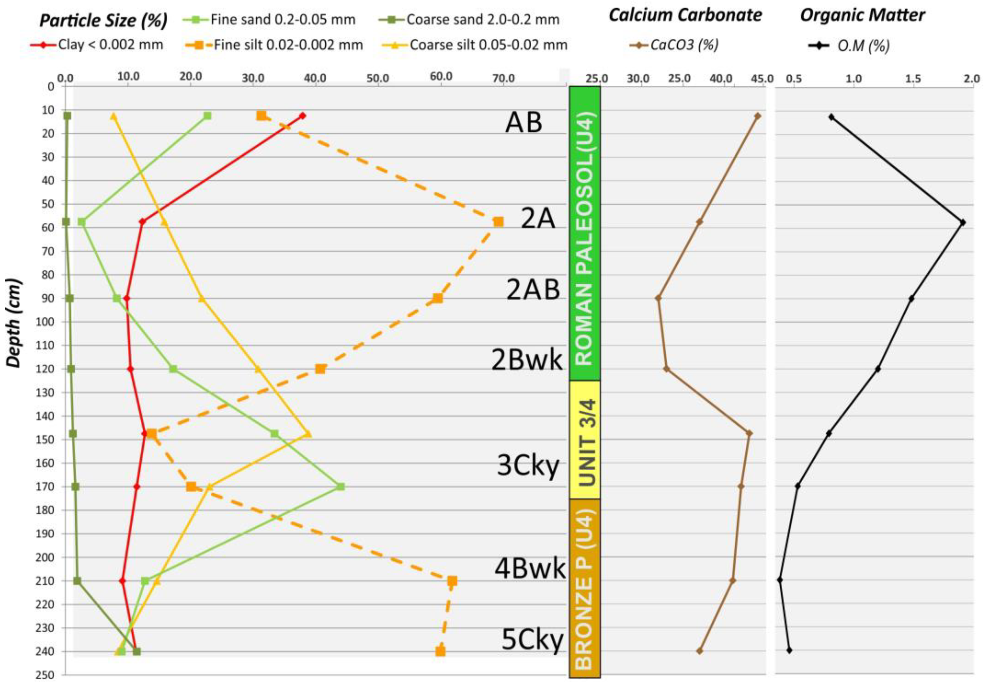
The colors of paleosols are referred to Munsell Soil Color Chart [33], measured in dry (d) or wet (w) conditions. Samples from paleosol horizons were collected for laboratory analysis following standard procedures of the USDA Soil Survey Laboratory methods [34,35]. Following these standards, textural analyses were determined through the standard test method for particle-size distribution of soils D 422-63 proposed by the American Society for Testing and Materials [35]. Calcium carbonate content was analyzed by the Woodward methodology [36], and the organic matter content was analyzed according to the Walkley and Black method [37]. According to the usual practice in soil field studies, we describe the most relevant paleosol features from top (surface) to bottom in the stratigraphic succession studied.
Undisturbed samples were collected for micromorphological study at the La Alcanara section. Vertical thin sections, 9 cm long and 5.5 cm wide, were made from air-dried undisturbed soil blocks and prepared in the University of Lleida (Soil Micromorphology Lab). Thin sections were studied and described by means of a polarizing microscope following the guidelines of Stoops [38] for the analysis of soil microfabrics related to microscopic soft-sediment deformations structures observed in some outcrops of the area [19].
Typical stratigraphic, sedimentary and lithological features of alluvial units were also considered for analysis, as well as the present assemblage of sediment and landforms (overlaying or inset) in order to establish the sequence of process during the Holocene to be compared to geomorphological schemes [2,3,10,39,40,41,42] and geochronological models [5,8,14,15,16] existing for the zone.

4. The Holocene Sequence of the Karting Espuña Section: Sedimentology and Chronology

4.1. Sedimentological and Stratigraphic Features

The outcropping sediments appear in the subvertical face of the left margin of the incised Guadalentín channel, which in this zone is about 22 m wide and 8–9 m deep. The studied sedimentary and paleosol sequence displays a thickness of 5.5 m and can be divided into five main units of 1.2 to 2.2 m thickness overlaid by sandy overbank deposits that are 23 m thick, labelled as Unit 5 (U5) in Figure 2. This unit contains a large number of terrestrial gastropods and charred materials, and regional geochronological data indicate that most of these overbank deposits corresponds to late-Roman to post-Roman historical flood events [6,29]. However, the sandy materials of Unit 5 were sampled for OSL and radiocarbon dating (Figure 2). Unfortunately, the quartz of sample KART-5 was not suitable to determine the OSL burial age (Table 2), but radiocarbon dating resulted in a medieval age of 1280 ± 30 cal BP (665 to 775 BC) concurrent with regional data (Table 3).
The underlying units (U4 to U1) are mainly composed by massive silts and clays, with occasional interbedded levels of fine sands containing gastropods, shells, charcoal or charred materials. Most of the sediments are constituted by massive silts or clayey silts interbedded with fine sands indicating low-energy environments typical for distal alluvial fan and playa-lake conditions (Figure 2 and Figure 4). Only the upper overbank deposits (U5) contain fine to medium sandy levels with occasional lenses of very small gravels with planar and crossbedding. In the studied section, only the erosive base of Unit 3 (U3) shows clear signals of intervening processes, while the rest of the units are topped by relatively well-preserved paleosols (Figure 2). However, in other downstream sections (i.e., La Alcanara, Librilla) important erosive processes are recorded [5,7,8], but in most of the cases, the intervening erosion is manly featured by vertical-linear dissection by torrential gullying and paleosols are well-preserved at both sides of the paleogullies [6,7,8].
The basal 2–3 m are partially covered in the studied section, but in nearby outcrops this lower unit is partially visible (U1 in Figure 2). In these outcrops, described by Calmel-Ávila [5,7,8], this basal unit is mainly composed of sticky massive clays of grey color with interbedded layers of sands and a relevant presence of scattered crystals of halite and gypsum. This unit presents basal gravel lags in which pottery fragments and sherds are common. The unit is topped by a paleosol with a Bwk horizon of pink-grey color (7.5 YR 7/2) with an important content of calcareous matrix (40%) and a low organic matter content (0.5%). These features are also common in other sites around the central sector of the basin (i.e., Librilla) indicating the most arid conditions within the basin during the early Holocene [5,7,8]. The two other basal units (U2 and U3) also contain a significant content of secondary gypsum (vermiform), which decreases upwards throughout the sequence. On the contrary, Unit U4 is nearly free of gypsum and the occurrence of small fresh-water gastropods and discontinuous fine sand levels are common, suggesting less dry conditions at basin center locations during younger Holocene times. However, as mentioned above, semi-endorheism prevailed within the basin until recent historical times [6,9].

4.2. Geochronological Analysis

Figure 2 summarizes the geochronological study carried out in the present work, showing the location and age of the analyzed OSL (KT) and radiocarbon (CR) samples in relation to the different sedimentary units described above. Specific geochronological lab-data are listed in Table 2 (OSL) and Table 3 (14C). Obtained radiocarbon dates match rather well with the regional geochronological models proposed for the Holocene filling of the Guadalentín Basin [5,6,7,8]. Samples CR3 and CR4, collected in Unit 2 (Figure 2) yielded consistent radiocarbon ages of 4510 ± 40 and 5910 ± 30 years cal BP (Table 1), which are rather consistent with those regionally assigned to the Chalcolithic unit in the area (c. 4.0–4.9 ka). Samples CR2 and CR1 were collected in Unit 4 from gastropods shells. CR1 resulted in an anomalous modern age (post-bomb), but CR2 at the base of the unit throws an age of 1980 ± 30 years cal BP (BC 100 to AD 20; Table 3), coinciding with the Roman period (Figure 2). This unit is largely recognized in the Guadalentín Depression, conspicuously dated in different geochronological analysis for paleoclimatological and paleoseismological studies in the area [6,12,17]. Finally, the sample CR5 was collected in gastropods levels of the top sandy overbank deposits (Figure 2) showing an age of 1280 ± 40 years cal BP, which locates these materials in the post-Roman times during the Medieval Age (AD 665775: Table 1). Sedimentary units 1 and 3 and the intermediate Unit 3/4 did not contain datable material for radiocarbon, but it was possible to date them by OSL analyses (Figure 2; Table 2).
Burial ages derived from OSL are listed in Table 2. The obtained ages can be separated in two different groups, those ones which match well with the radiocarbon dates (KART-1 and KART-2) and those which display much older ages than the ones obtained from radiocarbon dating (KART-3 and KART-4). Sample KT5 in the overbank deposits of the top of the sequence (Figure 2) presents a significant anomaly, since this sample has no crystalline quartz grains, and therefore, it has no luminescence response to light stimulation (see Section 2). KART-1 is in the top of Unit 2 corresponding to the Roman period and gives burial age of 1700 ± 10 years congruent with the existing radiocarbon dates (Table 1 and Table 3). KART-2 corresponds to Unit 3, without radiocarbon data in the studied section (CR1; Table 3), and yields an OSL burial age of 2600 ± 40 years (Table 2), consistent with both regional radiocarbon data for the Bronze Age unit and related paleosol features in this zone of the Guadalentín Depression [6,20].
On the other hand, burial ages corresponding to samples KART-3 and KART-4 present pre-Holocene date between 10.0 ± 1.1 ka and 19. 8 ± 1.7 ka (Figure 2; Table 2), incongruent with regional geochronological approaches based on radiocarbon data [5,6]. As suggested in Section 2, this set of samples underwent underexposure or incomplete bleaching of the transported quartz grains, due to the rapid torrential nature of the sedimentation process, displaying inherited dose rates from older sediments reworked from upstream locations. KART-3 (10.0 ± 1.1 ka) was collected in Unit 2, which has two radiocarbon dates indicating a typical Chalcolithic age between 4.5 and 5.9 ka (Figure 2; Table 3), although these dates match better with the end of the Neolithic period in the Iberian Peninsula. KART-4 (19.8 ± 1.7 ka) is in the basal unit, with no radiocarbon data for the studied sequence, but is regionally assigned to a general Meso-Neolithic unit with ages older than 6.7–7.0 ka [7]. Therefore, the obtained OSL age, close to the Last Glacial Maximum (LGM), can be considered an anomaly difficult to integrate in the regional geochronology. However, paleoseismological trenches in the zone (Figure 1) display fragmentary data for sedimentary units in the base of the sequences with some radiocarbon ages between c. 10 and 17 ka BP [17] (Table 1). However, these dates are normally mixed with other samples displaying much younger ages from c. 7.5 to 2.8 ka BP for the same sedimentary units [17], and their interpretation is difficult (i.e., reworking and contamination processes expected).
To the north, where the Guadalentín channel is incised between 11 and 15 m in the Holocene filling of the basin (i.e., Puente Nuevo and Librilla sections; Figure 4); Late Pleistocene deposits with ages between c. 20 to 33 ka BP have been reported and described for the base of the Holocene sequences [4,7,43,44,45]. The pioneer works of Cuenca Payá and Walker [43,44,45] on the geoarchaeology of the Guadalentín Depression reported ages of c. 20–23 ka BP for pre-Holocene palustrine deposits and associated fine detrital sequences around Librilla (laminated marls and silts; CPW samples in Table 1). In this paper, we include new data of travertine deposits located underneath the Holocene sequence in the Puente Nuevo Section with ages ranging between c. 33 and 31 ka BP (Table 3), with the oldest sediments recorded within the Guadalentín Depression at basin center locations. Age data were preliminary reported by Calmel-Ávila [4], but the dated deposits are for first time featured, described and properly assembled within the sedimentary sequence of the Guadalentín Basin in this paper. The dated materials are within a ~7 m thick silty marl unit outcropping at the base of the Holocene sequence (Figure 4a). The unit contains discrete travertine levels that are 0.4–0.5 m thick constituted by dense carbonated root-mat systems (Figure 4b), which yield a Late Pleistocene age corresponding to the final stages of the Marine Isotopic Stage MIS 3 (c. 33–31 ka BP). These data suggest the occurrence of low energy and relatively humid lacustrine environments in the zone before the onset of the Last Glacial (MIS 2). This travertine unit laterally and vertically shift to the palustrine deposits (c. 20–23 ka BP) originally described by Cuenca-Payá and Walker around Librilla [7,40,45]. Where visible, the contact of the Late Pleistocene and the Neogene substratum displays a large erosive unconformity with the development of giant (0.6–0.9 m depth) desiccation cracks (Figure 4c). Near Librilla and El Romeral (Figure 1) the travertine unit is cut by a 23 m thick unit displaying sandy and gravel facies with crossbedding structures and cobbles providing evidence of a high-energy torrential environment (see Section 5.). There is no available dating for this unit in the entire basin, but it can be tentatively ascribed to the base of the Meso-Neolithic unit or an earlier different unit. Regional stratigraphic data indicate that this torrential unit presumably deposited during the deglaciation period (c. 16–14 ka BP) in a phase of high river discharge after a long time of incision of the rambla systems in the zone [4,6,7,8]. Vertical stream incision caused lineal gullying at basin center locations but favored soil development in the non-eroded inter-gully flat locations on previous distal fan to palustrine sediments.
In fact, all the analyzed sedimentary units are topped by variably developed paleosols (Figure 2), which is a common feature throughout the basin [6,7,8,13]. These indicate important periods of no relevant sedimentation, fluvial incision and soil formation, which are also documented in the headwaters of the basin as staircased terraces [5,15] as well as in the regional paleoenvironmental records [14,15,29,39]. As shown in the following section, an important aridification is overprinted throughout the late Holocene sedimentary sequence as revealed by the important amount of CaCO3 (33–44%) present in all the studied paleosols (Figure 5). In fact, the Holocene is one of the main periods for calcrete development in the semiarid SE Spain [39]. In particular, the middle Holocene between c. 8.5 to 2.5 ka BP shows the most important peaks for calcic soil development [14,15].

5. The Paleosol Profile of the Karting Espuña Sequence

Once the sedimentological features and chronology of the analyzed sequence are established, we describe the most important morphological and pedological features of the different soils topping the sedimentary units. As mentioned in Section 2, according to the usual methodology in soil field studies [34], we describe the paleosols from top (surface) to bottom in the stratigraphic succession, differentiating five cycles of soil formation (1 to 5) from younger to older (Figure 2 and Figure 5).
Post-Roman overbank deposits on Unit 5 do not show signals of important soil development. Only some rhizoliths and a weak accumulation of calcium carbonate are observed. In contrast, the underlying soil sequence displays well-preserved morphological features with the following sequence of horizons from the top to the base of the sequence: AB-2A-2AB-2Bwk-3Ck1-3Ck2-4Bwk-5Cy. Geochronological data presented in the previous section indicate that pedogenic cycles 1 and 2 correspond to the Spanish Roman period, and cycle 4 corresponds to the regionally recognized Bronze Age paleosol (Figure 2 and Figure 5). Cycle 3 represents an important erosive gap between cycles 2 and 4. It is represented in the studied profile by reworked materials coming from the erosion of underlying units (Unit 3/4 in Figure 2 and Figure 5). Finally, the basal materials of these sections correspond to the Chalcolithic unit labelled here as cycle 5 (Figure 3).
The studied paleosol sequence begins just under the base of the post-Roman overbank deposits of Unit 5 (Figure 2 and Figure 5). These post-Roman deposits do not show any relevant soil signatures, only a few small rizholites, and therefore they were not considered for this study. Consequently, we consider the upper AB horizon as the indicator of the beginning of geomorphic stability that allowed for the initiation of pedogenic processes close to the end of (or just after) the Roman period. The AB horizon represents the remaining surface horizon of the whole described sequence, and therefore it is not necessary to design it as 1AB (Figure 5 and Figure 6a) according to the USDA and FAO standards [31,32]. This first horizon has a variable thickness (10–25 cm) along the studied section, and it has been truncated by the very thick alluvial deposits burying the paleosol sequence. AB horizon displays brown color (10YR 5/3 dry) of clay loam texture, medium organic matter content and a high content of calcium carbonate equivalent resulting from the leaching processes of the overlying fluvial facies.
The underlying horizon sequence (2A-2AB-2Bwk) is associated with the Roman period (Figure 2). This is composed of an upper organic-mineral horizon (2A) topping a transitional horizon 2AB in which the accumulation of organic matter (2%) is the highest recorded in the studied section (Figure 5). In this first paleosol, the most relevant pedogenic feature is the horizon 2Bwk, which is 35 cm thick, with a brown color (10YR 5/3, dry) and a silty loamy texture, with the fine silt fraction as the most important component (71%; Figure 5). This horizon displays a weak blocky structure, in small subangular blocks (Figure 6a), indicating early soil development allowing us to classify it as a “Cambic Horizon” of the Soil Survey Staff Classification [32]. The entire paleosol profile of cycle 2 is 95 cm thick and holds a high content of calcium carbonate equivalent (Figure 5), indicating an accumulation linked to the leaching processes from the overlying horizons and post-Roman overbank deposits. However, this appreciable CaCO3 content can also be influenced by carbonate inheritance from basin margins where important Miocene to Pliocene carbonate formations outcrop.
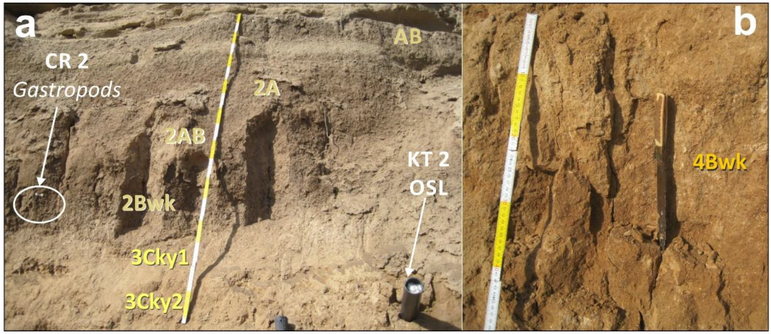
The next important paleosol in the studied profile is the one linked to the top of the Bronze Age unit, which is one of the most distinctive Holocene geomarker within the Guadalentin Depression [4,5,6,20]. In this zone, only a single B horizon is preserved (4Bwk) since the paleosol underwent significant erosion (Figure 3). This horizon stands out in the sequence, by its characteristic dull-orange color (7.5YR 6/4 moist) and a large moderate to strong prismatic structure (Figure 6b). Other soil features of this horizon are its silty loam texture, the low content of organic matter and high content of equivalent calcium carbonate (40%) linked to bleaching processes of the surface horizon of its original profile, which is nowadays truncated. These features allow us to classify this horizon as a Cambic horizon, but is more evolved than the one corresponding to cycle 2 (Roman), as evidenced by its strong prismatic structure (Figure 6b).
Between these two most prominent paleosols, there is the intermediate Unit 3/4, which partially erodes the underlying Bronze Age paleosol (Figure 2). This unit is affected by a different pedogenic cycle (3Cky1-3Cky2) on the coarse-grained detrital materials of the sequence (Figure 5; sands + coarse silts > 70%). These horizons display a light yellowish-brown color (10YR 6/4 dry) and present a massive structure with a loam to silty loam texture. The most significant feature is the notable enrichment in calcium carbonate and a widespread presence of vermiform gypsum of pedogenic origin. Both features can be considered as secondary features, a consequence of the leaching of carbonates, gypsum and other soluble salts from overlying horizons or basin margins, where Miocene limestones, marls and gypsums (Messinian) constitute the headwater of the tributary rambla systems in the basin margins of this sector of the Guadalentín Depression. In fact, this interbedded unit shows an important erosive basal contact with the Bronze Age soil (Figure 3) and can be interpreted as reworked materials coming from important processes of intrabasinal erosion, which is also relevant in other analyzed sites in the zone (Figure 7) [5,6].
The studied soil sequence finishes with a basal horizon 5Cky composed by massive clayey silts and fine silts (>60%; Figure 5) of pink-grey color with an important content of calcium carbonate 40%), significant organic matter (0.5%) and a relevant presence of secondary gypsum (Figure 5). Very small greenish, black and orange spots appear, indicating hydromorphic processes. This corresponds to the topsoil of the Chalcolithic Unit 2 in the studied profile. However, to the north, this paleosol displays a more developed B horizon (Bky) of pinky-brown color 5YR 7/4 on laminated silts and clays, containing not only numerous fragmentary elements of the Copper Age (pottery, bones, sherds) [41] and secondary gypsums, but also scattered crystals of halite [8]. These features suggest the occurrence of drier conditions or a more contrasted seasonality, allowing for the precipitation of evaporites during the end of the Copper Age. To follow the sequence of pedogenic cycles differentiated in this study, this paleosols’ horizons outcropping to the north will correspond to the cycle 5Bky.
The base of the studied sequence is partially covered, and it was assigned to the regionally recognized Meso-Neolithic unit, which constitutes the base of the Holocene sequence outcropping in this area [6,8]. Around the studied section, the Guadalentín channel is poorly incised (<10 m), only cutting Holocene deposits. In contrast, downstream in the Puente Nuevo–Librilla zone, the channel is incised up to 17 m, letting older Pleistocene materials to be exposed [6]. In the studied section, the Meso-Neolithic materials locally appear as a hardened sandy micritic material of dark grey color affected by hydromorphic processes. These are linked to the present fluctuating water table, which favors the precipitation of iron oxides and carbonates, triggering the “casehardening” of the riverbed (i.e., cementation) in many segments along the channel (sensu Lattman [46]). However, in the Librilla zone, studied by Calmel-Ávila [5,6,7,8], the Meso-Neolithic unit displays a maximum thickness of 7–8 m and is essentially constituted by laminated dark-brownish silty clays and fine sands with interbedded oxidized red-levels of hydromorphic origin. These materials have an important calcareous matrix (60%), a large amount of halite crystals and are topped by a B soil horizon of pinkish-grey color 7.5 YR 7/2 [8], indicating arid palustrine conditions for the early Holocene. Additionally, this basal Holocene sedimentary unit has embedded an important number of ceramic artefacts and habitation remnants from the Late Neolithic [45] associated to radiocarbon ages ≥ 6.5 ka BP [5,6]. As in the previous case, this paleosol will be labelled as 6Bky (Figure 8).
This basal unit of the Holocene presents two other relevant features for the interpretation of the geomorphological evolution of the zone: (a) An erosive base being indistinctively in unconformity over Late Pleistocene or Mio-Pliocene deposits, the last mainly being downstream of Librilla. (b) The topsoil records the last unequivocal primary tectonic deformations (surface faulting and folding) of the Holocene filling [43]. However, some secondary earthquake effects have been reported for the sedimentary and archaeological record of the zone, indicating strong paleoseismic events during the Late Bronze and Roman periods [12,17,18,21]. Figure 8 schematizes the ages and main soil, climatic and paleoseismic features of the Holocene sequence of the Guadalentín Basin.

6. Discussion

The geomorphological location of the studied sequence does not favor soil development, since it was located near the center of the basin under distal playa-lake to palustrine conditions, where pedogenic development are normally buffered by the work of water (i.e., permanent to occasional flooding). On the other hand, these environments negatively affect both the granulometry and the composition of the successive soil parent materials. The fine grain size dominated by the silt fraction, with a minimal coarse sand content (Figure 5), featuring the studied distal fan sediments, results in a low permeability, which reduces the action of the bleaching processes, hindering the formation of well-differentiated genetic horizons. However, despite the lack of optimal primary conditions for strong pedogenic development, the Holocene sedimentary filling of the Guadalentín Depression displays solid evidence of important stops in sedimentation (hiatus) leading to intervening soil development and subsequent erosion.
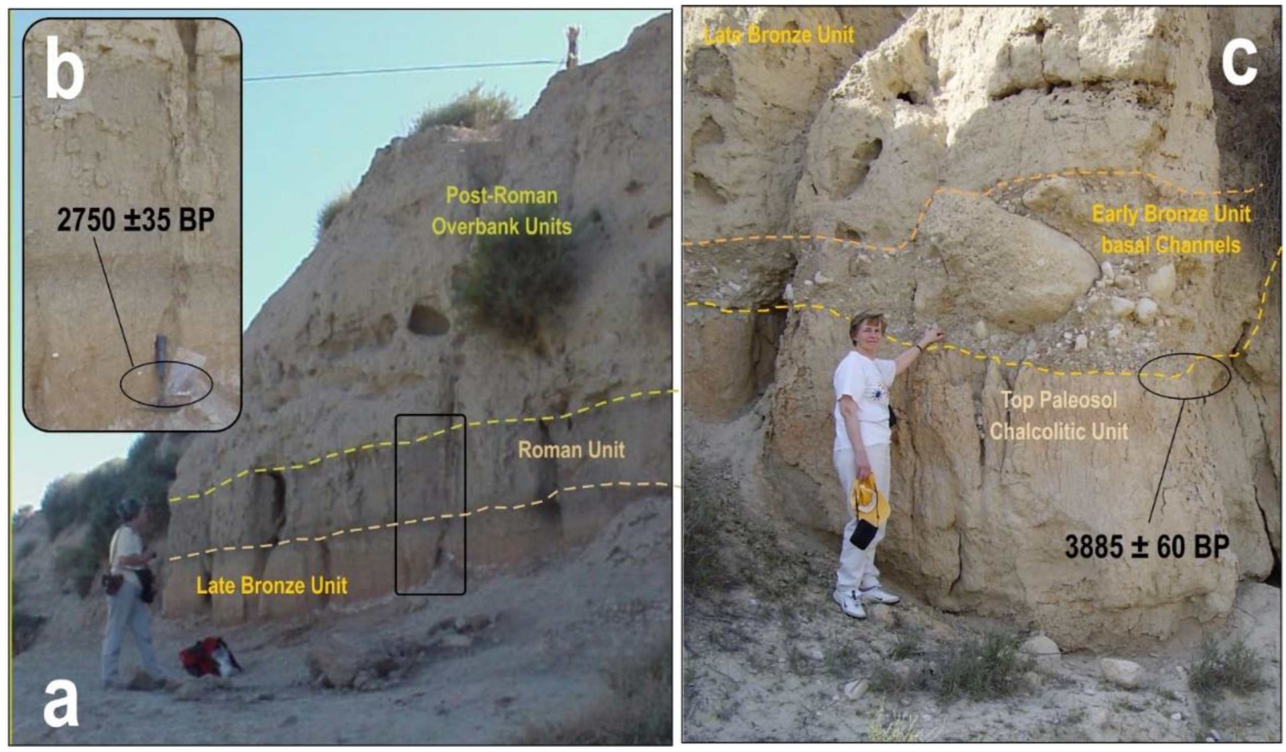
Except for the well-preserved soil horizons of the Roman Period paleosol, only mantled by overbank deposits (Figure 6a), all the studied paleosols are partially truncated by erosion processes with the upper A and AB horizons being removed. The intermediate Unit 3/4 represents a modest example of the erosive process that occurred between the development of the Bronze Age and Roman paleosols (Figure 2). However, in other zones located a few kilometers downstream (Figure 1; Venta del Rio), the contact between the Roman and Bronze units appears flat without visible indication of erosive signals (Figure 7a,b), suggesting lineal dissection processes. On the contrary, in those zones located near the junction of main tributary rambla systems (i.e., Algeciras or Librilla ramblas), the contact of the Chalcolithic and Bronze Age sedimentary units appears severely eroded with a conglomeratic basal lag including limestone blocks of the Neogene substratum of several cubic meters (Figure 7c). All these features indicate that intervening erosion episodes are closely linked to the first episodes of fluvial incision within the basin [6], which are notably larger towards downstream locations, where post-Bronze Age incisions reach 15–17 m [4]. Relationships between erosive processes and fluvial incision imply localized linear erosion, but large exposed areas subject to soil formation under contrasting climatic conditions.
Analyses of periods of sedimentation/erosion and soil formation in the semiarid SE Spain indicate that the interglaciar periods from marine isotopic stages MIS 7, 5 and 1 were the main periods for soil and calcrete formation in the area [14,39], with the present interglaciar (MIS1) as one of the most important episodes. Within the Holocene, the most relevant peak of soil formation occurred around c. 9.0–8.5 ka BP, just before the global scale climatic deterioration linked to the transition of the Greenlandian–Northgrippian stages [15]. This period is also identified as the starting point for fluvial incision–aggradation cycles and Holocene terrace development in the headwaters of the Guadalentín catchment upstream Lorca [16,30] (Point 10 in Figure 1). However, in the headwaters of the Librilla and Algeciras ramblas (to the north) terrace development did not start until c.2.7–2.5 ka BP [5] (Point 9 in Figure 1), indicating a significant decoupling in the fluvial connectivity of the different segments of the Guadalentín channel until Late Bronze times [16]. This lack of fluvial connectivity and sediment transfer throughout the Guadalentín can be linked to the occurrence of internal lithological barriers within the fluvial catchment, and to the proper evolution of the Guadalentín channel from an alluvial system to a proper fluvial system [6]. In this sense, the ancient Guadalentín fan, working under proximal aggradation until the Late Bronze Age, starts to be incised (fan-head trench) from Roman times, generating fluvial terraces in proximal locations but limited aggradation in basin center locations [6] (See Figure 1). Other relevant peaks of Holocene soil development in SE Spain occur at c.5.5 ka BP, 4.2 ka BP and 2.8 ka BP, nearly coinciding with Bond Cycles 4, 3 and 2 and important climatic crises in the Mediterranean [47] [ and Spain [48,49]. Those related with 4.2 and 2.8 ka BP events had special impact in SE Spain, causing relevant demographic crises and the final collapse of Chalcolithic populations (i.e., Los Millares; Almeria) and the Argaric populations of the Late Bronze Age [8,49]. These relationships suggest close feedback connections among fluvial dissection, fragmentation of the wetlands, soil development and depopulation processes during environmental crises.

6.1. Environmental Significance of the Late Bronze Paleosol

The 2.8 ka event had no remarkable impact out of the Iberian Peninsula, but in the studied area, it caused the final collapse of La Bastida de Totana, the largest settlement of the Bronze Age in the Iberian Peninsula [50]. The obtained data indicate that the Late Bronze crisis was related with aridification and drying of the wetlands at central basin locations as well as their partial dissection and fragmentation, allowing for extensive soil development out of the incised areas. Therefore, the deterioration and aridification of the existing wetlands, together with the carbonation and salinization of soils (i.e., secondary gypsums and halite crystals) led to an environmental collapse incapable of sustaining Bronze Age “argaric” populations in the zone from 2.8–2.5 ka BP. That is, the Late Bronze Age paleosol is the best developed soil in the region with a well-developed Bwk horizon displaying a significant prismatic structure (Figure 6b). On the other hand, this paleosol is a distinctive geo-feature within the Guadalentín basin dated in different outcrops in 2.725 ± 35 and 2.520 ± 50 Cal BP (Table 1), but also with a coincident OSL age of 2.6 ± 0.4 ka reported in this paper (Figure 2; Table 2).
The better development of the Late Bronze paleosol is probably linked to the occurrence of a wetter period after the Meghalayan droughts between c. 4000 and 2800 ka [5,13] which favored the soil-leaching processes. Subsequently, a period of increasing aridity contributed to the dehydration and induration of the Bwk horizon and the development of the characteristic “orange color” of this paleosol. From 2500 ka BP onwards, a semi-arid Mediterranean climate like the present one (<350 mm/year) started to be dominant, marked mainly by the incomplete bleaching of salts and carbonates and their accumulation in the subsurface horizons. In summary, this paleosol represents a drastic change in the evolution of the depression, with the beginning of the fragmentation of the wetlands by the incision of the drainage network. In other words, the Late Bronze paleosol would be contemporary with the first evidence of fluvial dissection at basin center locations. This allowed for the onset of the full connectivity of the fluvial system by the capture of the Guadalentín by the headwaters of the Sangonera rambla system (Figure 1) after the river overcame internal lithological thresholds, such as El Romeral Rock-Bar [4,16], which seems to be assisted by paleoseismic activity [6,18,47].

6.2. Environmental Significance of the Calcolithic Paleosol

A similar environmental scenario is proposed for the Copper Age populations of Los Millares in Almería, linked to the 4.2 ka BP event [49,50] coincident with the Northgrippian/Meghalayan transition [48]. This event is well documented in the Mediterranean and Middle East regions, linked to an important climatic aridification, with centenary devasting droughts, promoting the collapse of Bronze Age civilizations (Minoian, Hitites, Mesopotamia, etc.) in these areas. However, Copper Age settlements are scarce around the studied area and less important than the Bronze Age sites, so direct triggering factors among environmental and population crises are difficult to define. Whatever the case, the Chalcolithic paleosol displays even major signals of climatic deterioration, aridification and soil salinization than the Bronze Age paleosol [5,6,7,8,43], and a major environmental impact could be expected.

6.3. Environmental Significance of the Roman Period Paleosol

The Roman period paleosol displays a well-preserved sequence of horizons (2A-2AB-2Bwk), but shows a more limited development than the Bronze Age paleosol (Figure 6a). This paleosol points to more humid conditions (water availability), revealed by the increase of clay and organic matter content, the reduction of the carbonate content, the absence of secondary gypsum, the abundant occurrence of freshwater gastropods (Figure 6a and Figure 8) and, therefore, a partial recovery of the previously fragmented wetlands. The period of formation of this paleosol and the deposition of palustrine sediments at La Alcanara are coincident in age with the Roman Warm Period, recorded between 2600 and1600 cal yr BP in the southern part of the Iberian Peninsula [51]. In this zone of the Mediterranean, this period is characterized by a more humid and warmer climate, coinciding with the end of the Iberian civilization and the onset of the Roman occupation, locally labelled as the Iberian-Roman Humid Period (IRHP) [51]. Lacustrine and cave records of the IRHP in SE Spain feature this period as the wettest episode of the last 4000 years in the southern Iberian Peninsula [52,53]. However, the final stages of the IRPH in SE Spain (2000–1600 cal years BP) record a relatively drier phase, with the precipitation of gypsums levels in lakes [53] and cave speleothems [52]. These records indicate that the regional aridification started during the 1st century CE but peaked around 500–600 CE, roughly coinciding with the end of the Roman period in the Iberian Peninsula [52]. Radiocarbon and OSL ages reported in this paper match rather well with the different phases of the IRHP in Spain. In fact, after the serious depopulation of the zone at the end of the Late Bronze Age, the first signals of an important demographic recovery occur from c. 2.9–2.6 ka BP (900–600 BCE), coinciding with the onset of the Iberian culture in the zone [50]. Further evolution evidence drier conditions with the incision of the drainage network at basin center locations and their subsequent gullying [6].

6.4. The Post-Roman Environmental Evolution

After the end of the IRHP (c. 600 CE), the incision of the fluvial network re-started within the basin center. During this period, the headwaters of the ancient Sangonera rambla (Figure 1) definitively connected upstream with the Guadalentín channel. From this period, the development of the recent terrace system begun [5,15], as well as the occurrence of important overbank deposits caused by the characteristic torrential activity (flash floods) in the area [6,29,54]. This time coincides with the Medieval Arab period in the Murcia region (AD 713–1244) and with a large artificial re-organization of the drainage in the area by means of the construction of ditches, dams and the enlargement and construction of new irrigation canals, with a large impact in the landscape [55,56]. During this period, the irrigation works in the interfluve between distal zone of the ancient Guadalentín channel and the headwaters of the Sangonera rambla resulted in excavation of 8–9 m depth ditches [55] to fix the connection of both rambla channels and prevent the periodical inundation of the zone [9,56]. Irrigation works during the Middle Ages allowed for the eventual fluvial connectivity throughout the Guadalentín catchment upstream the zone of Librilla–El Romeral where the initial aggradation of the terrace system (T +5–6 m) is dated to 1088–1370 cal AD [8,57]. This period coincides with the main recent phases of floodplain aggradation in the Iberian Peninsula rivers [15,29,55]. After this episode, important fluvial aggradation within the Guadalentín channel is renewed during the early Little Ice Age (LIA) with the deposit of the terrace T +2–3 m from the 16th century to the middle 19th century [57] (Figure 8). In this scenario, the ancient wetlands at basin center locations underwent a progressive fragmentation, deterioration and transformation into small salt marshes that currently function as halophilic crypto-wetlands [11] as occurred in many zones of the western Mediterranean basin since Late Bronze Times [58]. In parallel, large hydraulic engineering works from the early 19th century have stabilized and artificially channelized [6,9] the current exorheic drainage of the Guadalentín Depression.

6.5. Paleoseismic Evidence of Earthquakes Holocene Sedimentary Sequence

The studied area is one of the most seismically active zones of Spain and significant earthquakes occurred during the historical and prehistorical times all along the nearby Lorca-Alhama de Murcia Fault (LAF, Figure 1) [3,4,18,47]. This important strike-slip fault was responsible for the 2011 Lorca Earthquake (5.1 Mw) [59], which triggered numerous earthquake environmental effects (important slope movements) around the area [60]. Despite the significant records of surface faulting along the fault trace by means of paleoseismic [59] and archaeoseismic research [18], the Holocene sequences in the area display signals of secondary earthquake geological effects during the initial phases of the Roman period is Spain (c. 100 BCE to 200 CE). Here, we briefly review those features related to liquefaction processes and slope movements recorded at La Alcanara section [12] and the Acopios-El Rio paleoseismic trenches [17], respectively (points 4 and 5 in Figure 1).
The slope movements are represented by a significant gully-wall collapse recorded at the paleoseismic trenches excavated in the zone (point 5 in Figure 1), which are synthetically represented as “event y” in the schematic cross-section of Figure 8. The collapse occurred along the presently buried subvertical plane of Los Tollos Fault (LTF, Figure 1) controlling an ancient linear gully-wall. Despite the fact that some authors argued about the occurrence of surface faulting in the area along this fault during Roman times, the excavated paleoseismic trench at El Rio Site only shows a single slope movement along the ancient fault plane of the TLF, with the younger affected beds being 2000–1880 cal years BP, which were buried by post-Roman sediments bracketed between 1010 and 1270 cal years BP [17] (Table 1; Figure 8). Results for nearby trenches (Acopios trench) excavated across the TLF in this zone only show clear signals of surface faulting for older periods between 2740 and 2140 cal years BP [17] (Table 1). These dates are consistent with the last signals of surface faulting by paleoseismic events ≥ 6.0 Mw recorded in the central segment of the LAF [59], especially that recorded by archaeoseismological evidence at the Bronze Age site of La Tira del Lienzo (≤3500 cal years BP; Table 1) [18] and near Totana (Figure 1).
Bronze Age paleoseismic signals are also recorded in the excavated paleoseismic trenches in the zone [17] as presumably secondary co-seismic displacements along the trace of the TLF, but also as anomalous flexures along the trace of other secondary faults, such as El Romeral [47] (Point 8 in Figure 1). In summary, these paleoseismic signals previously interpreted as independent faulting events can be explained as limited sympathetic displacements along secondary faults triggered by the strong Late Bronze earthquake (6.3–6.5 Mw) recorded in the nearby and more important LAF [18,59]. This early paleoseismic evidence within the Holocene sequence is graphically illustrated in Figure 8 as “event x” affecting the Meso-Neolithic, Calcolithic and Bronze Age units.
In a similar way, paleoseismic evidence linked to the Roman period at El Rio trench (gully-wall collapse) can be interpreted as a single slope movement (≤10 m3) triggered by a regional earthquake occurred along the LAF. Collapses on subvertical gully-walls are a typical secondary earthquake effect of the ESI07 Macroseismic Scale triggered by moderate seismic events (5.0–5.5 Mw) with intensities ≥ VII in radius of ~10 km around the epicenter [60,61]. Similar collapses in near-vertical gully slopes up to 6–7 m high were recorded around the epicentral area of the recent 5.1 Mw 2011 Lorca earthquake [59]. Since the excavated collapse is buried by sediments dated as 2000–1880 cal years BP (Table 1), the occurrence of an earthquake just after the 2nd century CE (Roman period) can be inferred. In any case, this event disturbed an incised gully, so fluvial incision linked to the second more dry episode of the IRHP [53] was already active. This second paleoseismic evidence is graphically illustrated in Figure 8 as “event y” affecting the top of the Bronze Age unit.
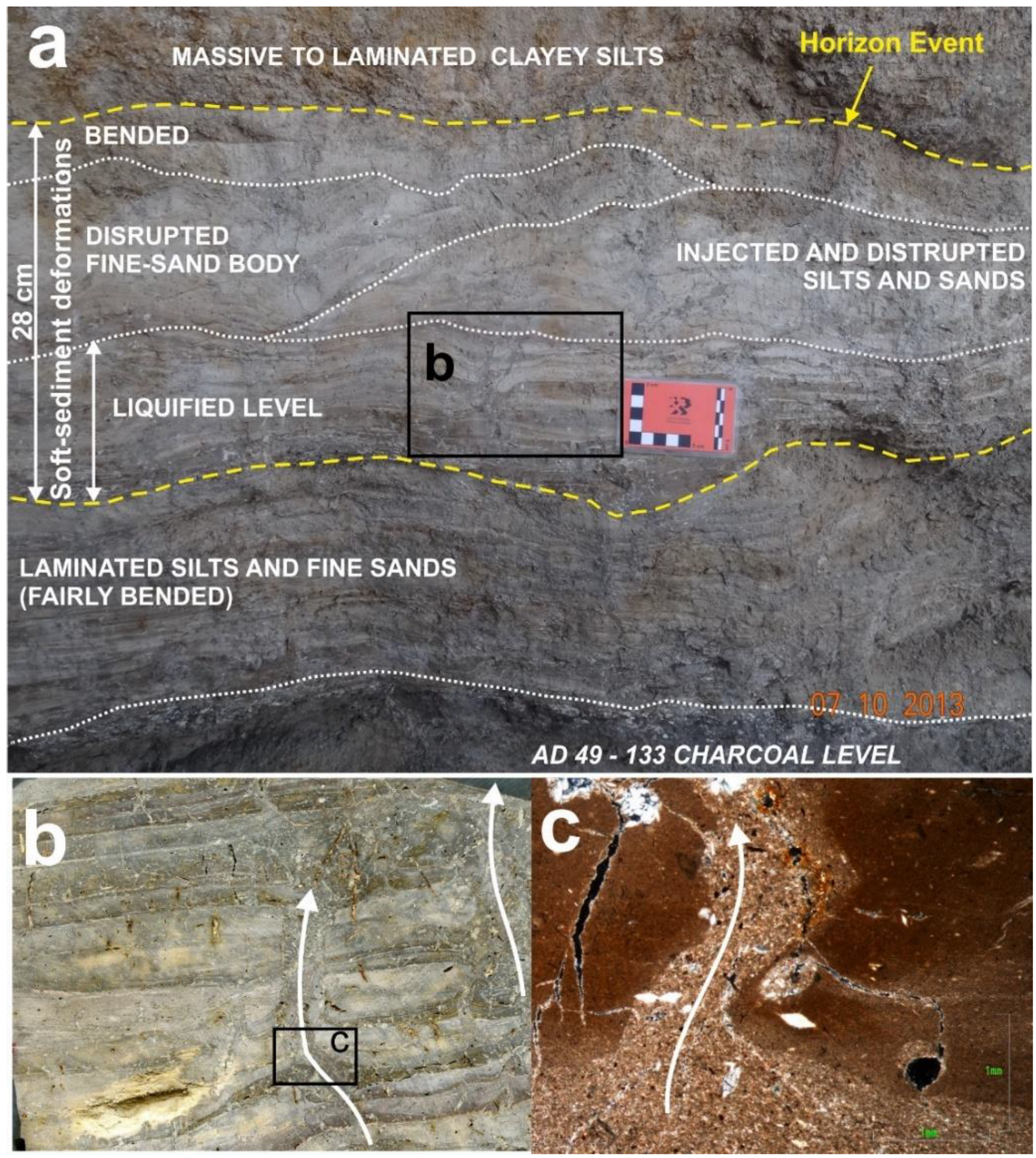
Liquefaction processes are evidenced as pervasive soft-sediment deformations in a liquefied level just above sediments dated 1850 ± 40 years cal BP (Table 1) in the La Alcanara section, which yield a calendar age that lies within the two first centuries CE (AD 49–133). Macro and micromorphological analyses of this liquefied level display fabrics of soft-sediment deformations generating a disturbed horizonca. 28 cm thick (Figure 9a) identified as “event z” in Figure 8. Studied samples and thin sections show multiple sand injection dikes, sand flames and pillow-and-ball structures from the centimetric (Figure 9b) to millimetric scale (Figure 9c). These multiscale liquefaction features pervasively affect the whole deformed horizon blurring or disrupting the original sedimentary lamination (Figure 9a). The liquefied level is entirely buried by undeformed massive clayey silts of post-Roman age [6]. Similar situations occur at the collapse structure of the event y in El Rio Trench (Figure 8) also mantled by post-Roman to medieval sediments bracketed between 1010 and 1270 cal years BP [17]. In fact, paleoseismic evidence of events y and z can be explained as originated by a same single event (yz) during the Roman period, since they display overlapped ages and they are located less than 1 km apart from each other. The reported features at both sites will be consistent with a no surface faulting regional event along the LAF of moderate magnitude (5.0–5.5 Mw) and local intensity VII–VIII [11,19], like the one that struck the City of Lorca in 2011 [58,59]. These values of magnitude and intensity are the cut-off empirical values for seismically induced liquefaction considered in the ESI-07 macroseismic scale [60] and co-seismic field records for moderate events and experimental tests [61].
Whatever the case, other energetic geological processes could help to magnify the deformations or anomalous records that occurred during the Roman period in the region, since some authors refer to the occurrence of a catastrophic flash-flood event around the old Roman city of Lorica (Lorca) between the years 110 BCE and AD 130 [29], historically known as the 47 BCE Julius Caesar Flood [54].

7. Conclusions

The geochronological analysis of the Holocene sedimentary sequence filling the Guadalentín Tectonic Depression (Murcia, SE Spain) allowed us to identify the four major regional sedimentary units (Figure 8) in a single section: The Karting Espuña section (Figure 2). The identified units are topped by variably developed paleosols showing Bw or Bk cambic or calic horizons, affected in all cases by significant intervening episodes of erosion. A complete single-section (log-style) analysis for the Guadalentín Depression is presented for the first time in this paper, combining 14C and OSL age data. The resulting ages are compared with regional data coming from 11 different sites in the zone (Figure 1), which are extremely consistent, except the OSL burial ages obtained for the two lower units. These two ages are older than expected regarding the radiocarbon ages obtained in the analyzed sequence (Figure 2), as well as in the regional records.
The entire dated sequence at the Karting Espuña section (c. 11 m thick) records the last c. 9 ka, although data from downstream location (i.e., Librilla), where the Guadalentín channel is incised at 17 m, expose Late Pleistocene deposits (20–29 ka) with basal travertine horizons dated in 30–33 ka (Table 1; Figure 8). The studied sequence shows different sedimentary units and paleosols, which can be related to different historical periods on the basis to the obtained ages and archaeological elements (Figure 2 and Figure 8): Meso-Neolithic (Unit 1), Chalcolithic (Unit 2), Bronze Age (Unit 3) and the Roman period (Unit 4). Unit 5 represents overbank post-Roman deposits.
Soil morphology and properties from dated paleosols record different environmental crisis in SE Spain. The Chalcolitic paleosol develops soon after c. 4.6–4.3 ka, nearly coinciding with the transit of Northgrippian–Meghalayan stages, evidencing a drastic change from relatively humid to arid conditions, coincident with the collapse of the Copper Age civilizations in SE Spain (i.e., Los Millares, Almería). The Bronze Age paleosol developed under relatively more humid conditions, which indicates a more important and longer rupture (erosion) in the sedimentary sequence soon after c. 2.5–2.7 ka. These dates nearly overlap the eventual collapse of the Bronze Age civilizations in SE Spain (Argaric Culture), coinciding with the first stages of fluvial incision at basin center locations and the desiccation fragmentation of the ancient wetlands subject to a progressive decline since them. The Roman period paleosol developed under Mediterranean climatic conditions coinciding with the second phase of the IRHP in SE Spain [51]. During this phase, more arid conditions (semiarid) dominated, and the basin center environments progressively evolved from fluvio-palustrine to the present exorheic drainage. Some of these Roman soils and sediments display evidence of paleoseismic activity around c. 2.0 ka, with important signals of liquefaction and soft-sediment deformation at the macro-, meso- and micro-scale.
In summary, the sedimentary record of the Guadalentín Depression shows a progressive aridification over the Holocene period, punctuated by important environmental crisis. These intervening drier episodes allowed for local fluvial incision and widespread soil development over the ancient wetlands at basin center locations, as well as important correlative depopulation processes. These periods are geologically evidenced by enhanced soil development, archaeologically documented as severe cultural collapses and geomorphologically recorded as the transits from semi-endorheic to exorheic conditions. This is the progressive installation of the present drainage network and the subsequent fragmentation of the ancient wetlands.

Author Contributions

Project design, management, conceptualization, coordination, funding acquisition, field work, design of graphic information and writing—original draft preparation, P.G.S.; Soil analysis, field sampling and writing—review and editing, E.R.; Geochronological analysis, management of OSL data, design of graphic information and writing—review and editing, A.M.; Field work, management of geochronological data, writing—review and editing, T.B.; Field work and design of graphic information, J.É.; Field work, management of archaeological and paleoseismic data, M.A.R.-P. All authors have read and agreed to the published version of the manuscript.

Funding

This research is part of the Spanish Research Project I+D+i PID2021-123510OB-I00 (QTECIBERIA-USAL) funded by the MICIN AEI/10.13039/501100011033/. This is contribution of the QTECT-AEQUA Working Group.

Institutional Review Board Statement

Not applicable.

Informed Consent Statement

Not applicable.

Data Availability Statement

Not applicable.

Acknowledgments

The authors are grateful to the Maryvonne Calmel-Ávila (France) for her support, field guidance and assistance during the performed research. This is a contribution of the QTECT-AEQUA Working Group: Asociación Española Para el Estudio del Cuaternario.

Conflicts of Interest

The authors declare no conflict of interest.

References

  1. Silva, P.G.; Goy, J.L.; Somoza, L.; Zazo, C.; Bardají, T. Landscape response to strike-slip faulting linked to collisional settings: Quaternary tectonics and basin formation in the Eastern Betics, southeast Spain. Tectonophysics 1993, 224, 289–303. [Google Scholar] [CrossRef]
  2. Silva, P.G.; Harvey, A.M.; Goy, J.L.; Zazo, C. Geomorphology, depositional style and Morphometric relationships of Quaternary alluvial fans in the Guadalentín Depression (Murcia, SE Spain). Z. Für Geomorphol. 1992, 36, 325–341. [Google Scholar] [CrossRef]
  3. Silva, P.G. The Guadalentín Tectonic Depression, Betic Cordillera, Murcia. In Landscapes and Landforms of Spain; Gutiérrez, F., Gutiérrez, M., Eds.; World Geomorphological Landscapes Series; Springer: Dordrecht, The Netherlands, 2014; pp. 25–35. [Google Scholar] [CrossRef]
  4. Calmel-Ávila, M.; Silva, P.G.; Bardají, T.; Goy, J.L.; Zazo, C. Drainage system inversion in the Guadalentín Depression during the late Pleistocene–Holocene (Murcia, Spain). In Advances in Studies of Desertification; Romero, C., López Bermúdez, F., Eds.; Serv. Pub. Univ.: Murcia, Spain, 2009; pp. 461–464. [Google Scholar]
  5. Calmel-Ávila, M. The Librilla “rambla” an example of morphogenetic crisis in the Holocene (Murcia, SE Spain). Quat. Int. 2002, 93–94, 101–108. [Google Scholar] [CrossRef]
  6. Silva, P.G.; Bardají, T.; Calmel-Ávila, M.; Goy, J.L.; Zazo, C. Transition from alluvial to fluvial systems in the Guadalentín Depression (SE Spain) during the Holocene: Lorca Fan versus Guadalentín River. Geomorphology 2008, 100, 140–153. [Google Scholar] [CrossRef]
  7. Calmel-Ávila, M. Procesos hídricos holocenos en el Bajo Guadalentín (Murcia, España). Cuatern. Y Geomorfol. 2000, 14, 65–78. [Google Scholar]
  8. Calmel-Ávila, M. Étude des paléoenvironnements holocènes dans le bassin du Bas-Guadalentín (Région de Murcie, Espagne). Géomorphologie 2000, 3, 147–160. [Google Scholar] [CrossRef]
  9. Silva, P.G.; Goy, J.L.; Zazo, C.; Bardají, T. Evolución reciente del drenaje en la Depresión del Guadalentín (Murcia). Geogaceta 1996, 20, 1385–1389. [Google Scholar]
  10. Harvey, A.M. Factors influencing Quaternary alluvial fan development in Southeast Spain. In Alluvial Fans: A Field Approach; Rachocki, A.H.J., Church, U., Eds.; John Wiley & Sons: New York, NY, USA, 1990; pp. 247–269. [Google Scholar]
  11. Páez Blázquez, M. La influencia de la gestión de las aguas en los criptohumedales de la región de Murcia: Saladares del Guadalentín y Ajauque-Rambla Salada. In Conflictos Entre el Desarrollo de las Aguas Subterráneas y la Conservación de los Humedales del Litoral Mediterráneo; Fundación M. Botín: Madrid, Spain, 2003; pp. 253–280. [Google Scholar]
  12. Silva, P.G.; Roquero, E.; Rodríguez-Pascua, M.A.; Bardají, T.; Giner, J.; Perucha, A.; Élez, J. Record of a Roman Earthquake (2nd Century AD) in the Guadalentín Depression (Murcia, SE Spain): Micro-morphological analysis of liquefaction. Geotemas 2016, 16, 391–394. [Google Scholar]
  13. Roquero, E.; Silva, P.G.; Élez, J.; Rodríguez-Pascua, M.A.; Medialdea, A. Registro edáfico de los cambios paleoambientales en la Depresión del Guadalentín durante el Holoceno (Murcia, SE España). In Actas XV Reunión Nacional de Cuaternario AEQUA; Universtiy of Vasque Country UPV-EHU: Bilbao, Spain, 2019; pp. 235–237. [Google Scholar]
  14. Silva, P.G.; Roquero, E.; Bardají, T.; Medialdea, A. Pleistocene to Holocene phases of sedimentation and soil formation in the semiarid SE Spain (Eastern Betic Cordillera). Cuatern. Y Geomorfol. 2020, 34, 41–61. [Google Scholar] [CrossRef]
  15. Silva, P.G.; Roquero, E.; Élez, J.; Bardají, T. Medialdea. Phases of sedimentation and soil formation in SE Spain during the Holocene (Eastern Betic Cordillera). Geotemas 2021, 18, 1027–1030. [Google Scholar]
  16. Rodríguez-Lloveras, X.; Machado, M.J.; Sánchez-Moya, Y.; Celleb, M.; Medialdea, A.; Sopeña, A.; Benito, G. Impacts of sediment connectivity on Holocene alluvial records across a Mediterranean basin (Guadalentín River, SE-Spain). Catena 2020, 187, 104321. [Google Scholar] [CrossRef]
  17. Insua, J.M.; García-Mayordomo, J.; Salazar, A.; Rodríguez-Escudero, E.; Martín-Banda, R.; Álvarez-Gómez, J.A.; Canora, C.; Martínez-Díaz, J.J. Paleoseismological evidence of Holocene activity of the Los Tollos Fault (Murcia, SE Spain): A lately formed Quaternary tectonic feature of the Eastern Betic Shear Zone. J. Iber. Geol. 2015, 41, 333–350. [Google Scholar] [CrossRef] [Green Version]
  18. Ferrater, M.; Silva, P.G.; Ortuño, M.; Rodríguez-Pascua, M.A.; Masana, E. Archaeoseismologic analysis of a Late Bronze Age site on the Alhama de Murcia Fault: La Tira del Lienzo (Murcia, SE Spain). Geoarchaeology 2015, 30, 151–165. [Google Scholar] [CrossRef]
  19. Bronk Ramsey, C. Bayesian analysis of radiocarbon dates. Radiocarbon 2009, 51, 337–360. [Google Scholar] [CrossRef] [Green Version]
  20. Reimer, P.; Bard, E.; Bayliss, A.; Beck, J.; Blackwell, P.; Ramsey, C.; Van der Plicht, J. IntCal13 and Marine13 Radiocarbon Age Calibration Curves 0–50,000 years cal BP. Radiocarbon 2013, 55, 1869–1887. [Google Scholar] [CrossRef] [Green Version]
  21. Roquero, E.; Silva, P.G.; Rodríguez-Pascua, M.A.; Giner-Robles, J.L.; Élez, J.; Perucha, M.A. Micromorphology of seismic liquefaction structures: A tool to record lost seismic events (Betic Cordillera, Spain). In Actas III Reunión Ibérica sobre Fallas Activas; IBERFAULT 3: Alicante, Spain, 2018; pp. 195–198. [Google Scholar]
  22. Aitken, M.J. Introduction to Optical Dating; Oxford University Press: Oxford, UK, 1998. [Google Scholar]
  23. Guérin, G.; Mercier, N.G.; Adamiec, G. Dose-rate conversion factors: Update. Anc. TL 2011, 29, 5–8. [Google Scholar]
  24. Prescott, J.R.; Hutton, J.T. Cosmic ray contributions to dose rates for luminescence and ESR dating: Large depths and long term time variations. Radiat. Meas. 1994, 23, 497–500. [Google Scholar] [CrossRef]
  25. Durcan, J.; King, G.; Duller, G.A.T. DRAC: Dose Rate and Age Calculator for trapped charge dating. Quat. Geochronol. 2015, 28, 54–61. [Google Scholar] [CrossRef] [Green Version]
  26. Murray, A.S.; Wintle, A.G. Luminescence dating of quartz using an improved single-aliquot regenerative-dose protocol. Radiat. Meas. 2000, 32, 57–73. [Google Scholar] [CrossRef]
  27. Galbraith, R.F.; Roberts, R.G.; Laslett, G.M.; Yoshida, H.; Olley, J.M. Optical dating of single and multiple grains of quartz from Jinmium rock shelter, Northern Australia: Part 1, experimental design and statistical models. Archaeometry 1999, 41, 339–364. [Google Scholar] [CrossRef]
  28. Thomsen, K.J.; Murray, A.S.; Bøtter-Jensen, L. Sources of variability in OSL dose measurements using single grains of quartz. Radiat. Meas. 2005, 39, 47–61. [Google Scholar] [CrossRef]
  29. Benito, G.; Rico, M.; Sánchez-Moya, Y.; Sopeña, A.; Thorndycraft, V.R.; Barriendos, M. The impact of late Holocene climatic variability and land use change on the flood hydrology of the Guadalentín River, southeast Spain. Glob. Planet. Change 2010, 70, 53–63. [Google Scholar] [CrossRef] [Green Version]
  30. Medialdea, A.; Thomsen, K.J.; Murray, A.S.; Benito, G. Reliability of equivalent-dose determination and age-models in the OSL dating of historical and modern palaeoflood sediments. Quat. Geochronol. 2014, 22, 11–24. [Google Scholar] [CrossRef] [Green Version]
  31. FAO Guideline for Soil Description, 4th ed.; Soil Resources, Management and Conservation Service, Land and Water Development Division FAO: Rome, Italy, 2006; 97p, Available online: http://refhub.elsevier.com/S0169-555X(19)30250-8/rf0050 (accessed on 1 May 2022).
  32. Soil Survey Staff. Keys to Soil Taxonomy, 12th ed.; USDA-Natural Resources Conservation Service: Washington, DC, USA, 2014; 360p.
  33. Munsell Soil Color Chart; Munsell Color Company, Macbeth Division of Kollmorgen: Baltimore, MD, USA, 1990; 50p.
  34. USDA Soil Survey Laboratory Methods; Soil Survey Laboratory Investigations Report No. 42; USDA-Natural Resources Conservation Service: Washington, DC, USA, 2014; 1001p, Available online: http://refhub.elsevier.com/S0169-555X(19)30250-8/rf0180 (accessed on 5 August 2022).
  35. Standard Test Method for Particle-Size Analysis of Soils D 422-63 (1972); Annual Book of ASTM Standards 04.08:117-127; American Society for Testing Materials: Philadelphia, PA, USA, 1985.
  36. Woodward, L. A manometric method for the rapid determination of lime in soils. Soil Sci. Soc. Am. Proc. 1961, 25, 248–250. [Google Scholar] [CrossRef]
  37. Walkley, A.; Black, I.A. An examination of the Degtjareff method for determining soil organic matter and a pro-posed modi-fication of the chromic acid titration method. Soil Sci. 1934, 37, 29–38. [Google Scholar] [CrossRef]
  38. Stoops, G. Guidelines for Analysis and Description of Soil and Regolith Thin Sections, 2nd ed.; Soil Science Society of America: Madison, MD, USA, 2003; 184p. [Google Scholar]
  39. Alonso Zarza, A.M.; Silva, P.G.; Goy, J.L.; Zazo, C. Fan-surface dynamics, plant-activity and calcrete development: Interactions during ultimate phases of fan evolution in the semiarid SE Spain (Murcia). Geomorphology 1998, 24, 147–167. [Google Scholar] [CrossRef] [Green Version]
  40. Candy, I.; Black, S. The timing of Quaternary calcrete development in semi-arid southeast Spain: Investigating the role of climate on calcrete genesis. Sediment. Geol. 2009, 218, 6–15. [Google Scholar] [CrossRef]
  41. Stokes, M.; Nash, D.J.; Harvey, A.M. Calcrete “fossilisation” of alluvial fans in SE Spain: The roles of groundwater, pedogenic processes and fan dynamics in calcrete development. Geomorphology 2007, 85, 63–84. [Google Scholar] [CrossRef]
  42. Roquero, E.; Silva, P.G.; Rodríguez-Pascua, M.A.; Bardají, T.; Élez, J.; Carrasco-García, P.; Giner-Robles, J.L. Geomorphology and pedology of faulted fan surfaces and paleosols in the Palomares Fault Zone (Betic Cordillera, SE Spain). Geomorphology 2019, 342, 196–209. [Google Scholar] [CrossRef]
  43. Cuenca Payá, A.; Walker, M.J. Nuevas fechas 14C para el sector de Alicante y Murcia. Trab. Neogeno Y Cuatern. 1977, 6, 309–318. [Google Scholar]
  44. Cuenca Payá, A.; Walker, M.J. Palaeoclimatic, palaeoenvironmental and anthropic interactions in SE Spanish Holocene prehistory. In Estudios Sobre Geomorfología del Sur de España; López Bermúdez, F., Thornes, J.B., Eds.; Serv. Pub. Univ.: Murcia, Spain, 1986; pp. 59–66. [Google Scholar]
  45. Lattman, L.H. Calcium carbonate cementation of alluvial fans in southern Nevada. Geol. Soc. Am. Bull. 1973, 84, 3013–3028. [Google Scholar] [CrossRef]
  46. Calmel-Avila, M. Tectónica activa y firmas morfológicas en el tramo medio de la fosa del río Guadalentín. In Actas XII Reunión Nacional de Cuaternario; Asociación española para el estudio del Cuaternario (AEQUA): Ávila, Spain, 2007; pp. 135–138. [Google Scholar]
  47. Walker, M.; Head, M.J.; Berkelhammer, M.; Björck, S.; Cheng, H.; Cwynar, L.; Fisher, D.; Gkinis, V.; Long, A.; Lowe, J.; et al. Formal ratification of the subdivision of the Holocene Series/ Epoch (Quaternary System/Period): Two new Global Boundary Stratotype Sections and Points (GSSPs) and three new stages/subseries. Episodes 2018, 41, 213–223. [Google Scholar] [CrossRef] [Green Version]
  48. Blanco-González, A.; Lillios, K.T.; López-Sáez, J.A.; Drake, B.L. Cultural, Demographic and Environmental Dynamics of the Copper and Early Bronze Age in Iberia (3300-1500 BC): Towards an Interregional Comparison at the Time of the 4.2 ky BP Event. J. World Prehistory 2018, 31, 1–79. [Google Scholar] [CrossRef]
  49. Aranda Jiménez, G. Resistance and social involution in the Bronze Age communities of southeastern Iberia. Trab. De Prehist. 2015, 72, 126–144. [Google Scholar] [CrossRef] [Green Version]
  50. Martín-Puertas, C.; Valero-Garcés, B.; Brauer, A.; Mata, M.P.; Delgado-Huertas, A.; Duski, P. The Iberian–Roman Humid Period (2600–1600 cal yr BP) in the Zoñar Lake varve record (Andalucía, southern Spain). Quat. Res. 2009, 71, 108–120. [Google Scholar] [CrossRef]
  51. Gázquez, F.; Bauska, T.K.; Comas-Bru, L.; Ghaleb, B.; Calaforra, J.M.; Hodel, D.A. The potential of gypsum speleothems for paleoclimatology: Application to the Iberian Roman Humid Period. Sci. Rep. 2020, 10, 14705. [Google Scholar] [CrossRef]
  52. Martegani, L.; Gázquez, F.; Moreno, A.; Valero-Garcés, B.; Morellón, M.; Bartolomé, M.; Martín-Puertas, C.; Rodríguez-Rodríguez, M. Abrupt lowstands of Laguna de Zoñar (southern Spain) during the Iberian Roman Humid Period recorded by stable isotopes of gypsum hydration water. In EGU General Assembly 2022; EGU22-1370; European Geophysical Union: Vienna, Austria, 2022. [Google Scholar] [CrossRef]
  53. Castejón Porcel, G.; Romero Díaz, A. Inundaciones en la Región de Murcia en los inicios del Siglo XXI. Rev. Bibliográfica Geogr. Y Cienc. Soc. 2014, 1102, 1–40. [Google Scholar]
  54. Vita-Finzi, F. The Mediterranean Valleys: Geological Changes in Historical Times; Cambridge University Press: Cambridge, UK, 1969; 207p. [Google Scholar]
  55. Pocklington, R. Acequias árabes y pre-árabes en Murcia y Lorca: Aportación toponímica a la historia del regadío. In Actes Xè Col·loqui General de la Societat d’Onomàstica: 1er D’onomàstica Valenciana; Universitat de València: Valencia, Spain, 1986; p. 462. [Google Scholar]
  56. Calmel-Ávila, M. Le petit âge de glace (PAG) dans la vallée du Guadalentín (Sud-Est de l’Espagne, région de Murcie). Mediterráneé 2014, 122, 113–119. [Google Scholar] [CrossRef]
  57. Balbo, A.L.; Martínez-Fernández, J.; Steve-Selma, M.A. Mediterranean wetlands: Archaeology, ecology, and sustainability. WIREs Water 2017, 4, e1238. [Google Scholar] [CrossRef]
  58. Martínez-Díaz, J.J.; Masana, E.; Ortuño, M. Active tectonics of the Alhama de Murcia fault, Betic Cordillera, Spain. J. Iber. Geol. 2014, 38, 170–181. [Google Scholar] [CrossRef] [Green Version]
  59. Silva, P.G.; Pérez-López, R.; Rodríguez-Pascua, M.A.; Roquero, E.; Giner Robles, J.L.; Huerta, P.; Martínez-Graña, A.; Bardají, T. Macroseismic analysis of slope movements triggered by the 2011 Lorca earthquake (Mw 5.1): Application of the ESI-07 scale. Geogaceta 2015, 57, 35–38. [Google Scholar]
  60. Michetti, A.M.; Esposito, E.; Guerrieri, L.; Porfido, S.; Serva, L.; Tatevossian, R.; Vittori, E.; Audemard, F.; Azuma, T.; Clague, J.; et al. Intensity Scale ESI 2007; ISPRA: Roma, Italy, 2007; p. 74. ISBN 9788824029032.
  61. Audemard, A.; De Santis, F. Survey of liquefaction structures induced by recent moderate earthquakes. Bull. Int. Ass. Eng. Geol. 1991, 44, 5–16. [Google Scholar] [CrossRef]
Figure 1. (a) Location of the studied area within the frame of the Betic Cordillera in the Iberian Peninsula; (b) Studied zone within the central zone of the Guadalentín Depression. Main Quaternary strike-slip faults (LAF; PLF, NCF; LMF¸LTF: see text) and different paleoenvironmental sectors defined for historical times by Silva et al. [6]. The numbered black stars indicate the location of other sections with geochronological data for the Holocene sequence: (1) Lorca, (2) La Hoya (3) Ventas del Río, (4) La Alcanara, (5) Acopios-El Rio trench sections, (6) Puente Nuevo, (7) Librilla, (8) El Romeral, (9) Fuente Librilla, and (10) El Estrecho-Embalse de Puentes. White stars identify the studied section (Karting Espuña), as well as important Bronze Age archaeological sites discussed in the text: (11) La Bastida de Totana and (12) La Tira del Lienzo. White circles show the location of the main localities in the studied zone.
Geosciences 12 00459 g001
Figure 2. Pedo-sedimentary sequence of the Holocene filling of the Guadalentin Depression at the section of Karting Espuña (south Totana; Figure 1). The location of samples for OSL (KT1–KT5) and radiocarbon dating (CR1–CR4) are displayed as well as the upper and lower limits (dashed lines) of the sedimentary units defined in the Guadalentín Depression with the bracketed radiocarbon calibrated ages (BP) proposed by Silva et al. (2008) [6]. The paleosol horizon sequence studied in this paper is also displayed in the profile: AB-2A-2AB-2Bwk-3Cky1-3Cky2-4Bwk-5Cy. Note differentiation by colors of sedimentary units and corresponding soil horizons.
Geosciences 12 00459 g002
Figure 3. Dose distributions for samples KART-1, KART-2, KART-3 and KART-4. Full icons indicate the individual doses from each measured aliquot. Open icons indicate the identified outliers, excluded from the equivalent dose estimation. Note that 60% of the measured doses were not included in the age estimation of sample KART-2.
Geosciences 12 00459 g003
Figure 4. Relationships among Late Pleistocene, Holocene deposits and the Neogene substratum at Puente Nuevo section (see location in Figure 1). (a) Assemblage of Late Pleistocene conglomerates and sands over the Neogene sediments. Scale Teresa Bardají 1.55 m. (b) Travertine levels in the Late Pleistocene deposits outcropping close to the base of Late Pleistocene deposits in the zone. Scale Estwing hammer 35 cm. (c) Details of the unconformity between the Neogene substratum and Late Pleistocene sediments near Librilla downstream the Puente Nuevo section. Note the impressive size of desiccation cracks 0.6–0.9 m deep.
Geosciences 12 00459 g004
Figure 5. Graphics displaying the percentages (%) of particle size distribution, organic matter and calcium carbonate contents, with depth of the studied paleosols. See location of the different soil horizons in Figure 2.
Geosciences 12 00459 g005
Figure 6. Pedogenic morphological features of (a) the Roman period paleosol Cycle 2 and (b) the Bronze Age paleosol of Cycle 4. Note (a) the incipient blocky structure in the horizon 2Bwk and (b) more developed prismatic structure in the horizon 4Bwk.
Geosciences 12 00459 g006
Figure 7. Soil/erosion relationships of different sedimentary units downstream the studied sequence. (a) Ventas del Rio Sequence and (b) detail of the dated gastropods level in the Bronze Age unit. (c) Erosional contact between the Bronze and Chalcolithic units in the Guadalentín–Librilla rambla junction displaying the approximate site of dating. Photo courtesy of Maryvonne Calmel-Ávila.
Geosciences 12 00459 g007
Figure 8. Synthetic cross-section for the Holocene sequence of the Guadalentín Basin (Murcia) studied in this paper. Left margins illustrate main features and overall radiocarbon chronology of the Karting Espuña profile studied in this work. Right margin expose the main sedimentary, pedogenic and paleoseismic features in close locations studied by other authors such as (a) 5Bky and 6Bky soil horizons reported by Calmel Ávila (2000a) and numbered (5, 6) following the sequence of pedogenic cycles differentiated in this work; (x) fault flexure affecting to the Meso-Neolithic soil at El Romeral Section reported by Calmel-Ávila 2007 [43]; (y) Paleo-Gully collapse of the Late Bronze Age buried by sediments of the Roman period recorded at the Rio Trench [17]; (z) liquefaction level of the Roman period reported at La Alcanara [11,19].
Geosciences 12 00459 g008
Figure 9. Liquefaction horizon of the Roman period evidencing an ancient earthquake during the Roman period in the studied zone. (a) Field outcrop at the base of La Alcanara section displaying convolute lamination (b) sediment sample extracted for micromorphological analyses displaying sand dykes, sand flames and ball-and-pillow structures with boudinage morphologies -see location in the quadrangle of Figure 9a; (c) thin section illustrating an injection of fine-sand dike filling hydrofractures in the lower disturbed levels -see location in the quadrangle of Figure 9b.
Geosciences 12 00459 g009
Table 1. Published radiocarbon data for the Holocene filling of the Guadalentín Depression related with the Roman and Bronze Age sediments and soils discussed in this work obtained from other sections of interest of the zone by Silva et al., 2008 [6]; Calmel-Ávila, 2000 [5]; and Calmel-Ávila, 2002 [8]. The dataset also includes selected radiocarbon data for the paleoseismic trenches excavated in the zone [17] and the pre-Holocene ages obtained by Cuenca and Walker in 1985 (CPW79 and CPW74) reported in the work of Calmel-Ávila, 2000 [5].
Section/ Sample Code Sed. UnitLab. Code14C Age (BP)Cal Age (BP)Cal. Age 2σ (BC/AD)Dated Material
VENTA del RIO T22-1 [6]
UNIT 3 (Bronze Age)
Ly-2147/OxA
Unv. Oxford Lab.
2725 ± 35 BPCal BP 2816 ± 35Cal BC 900–833Charcoal.
ALCANARA TT21-2 [6]
UNIT 4 (Roman)
Ly-2148/OxA
Univ. Oxford Lab.
1900 ± 40 BPCal BP 1854 ± 40Cal AD 59–133Charcoal
LIBRILLA MV-0 [8]
UNIT 3 (Late Bronze Age)
Ly-750/OxA
Univ. Oxford Lab.
2395 ± 50 BPCal BP 2597 ± 45Cal BC 749–405Charcoal
LIBRILLA MV-6 [5]
UNIT 3 (Late Bronze Age)
Ly-230/OxA
Univ. Oxford Lab.
2505 ± 45 BPCal BP 2597 ± 45Cal BP 793–503Charcoal
LIBRILLA MV-9- [8]
UNIT 5 (post-Roman)
Ly-130/OxA
Univ. Oxford Lab.
555 ± 50 BPCal BP 2597 ± 75Cal AD 1291–1471Shell-Gastropod
ROMERAL MV7 [5]
UNIT 3 (Late Bronze Age)
Ly-139/OxA-5372
Univ. Oxford Lab
3885 ± 60 BPCal BP 4244 ± 40Cal. BC 2463–2295Charcoal
ROMERAL MV8 [5]
UNIT 1 (Meso-Neolithic)
Ly-229/OxA.
Univ. Oxford Lab
6340 ± 60 BPCal BP 7298 ± 89Cal. BC 5395–5216Charred material
EL RIO TRENCH RI.23 UNIT 3 (Bronze Age)Beta Analytics
Rio-23
2530 ± 30 BPCal BP 1710± 30Cal. BC 740–2680Charred material
EL RIO TRENCH RI.9 UNIT 4 (Roman)Beta Analytics
Rio-9
2000 ± 30 BPCal BP 1940 ± 60Cal. BC 50–AD 70Org. sediment
EL RIO TRENCH RI.94 UNIT 5 (post-Roman)Beta Analytics
Rio-24
1250 ± 30 BPCal BP 1195 ± 75Cal. AD 680–830Charred material
ACOPIOS TRENCH A1-3
UNIT 4 (Roman)
Beta Analytics
A1-3
1790 ± 30 BPCal BP 1760 ± 60Cal. AD 130–260Charred material
ACOPIOS TRENCH A1N-4
UNIT 3 (Bronze Age)
Beta Analytics
A1N-4
2430 ± 30 BPCal BP 2690 ± 30Cal. BC 740–690Org. sediment
ACOPIOS TRENCH A1N-6
UNIT 3 (Bronze Age)
Beta Analytics
A1N-6
2650 ± 30 BPCal BP 2760 ± 20Cal. BC 840–790Org. sediment
ACOPIOS TRENCH A1-30
UNIT 3 (Bronze Age)
Beta Analytics
A1-30
10240 ± 40 BPCal BP 11820± 138Cal. BC 10140–9870Shell-Gastropod
ACOPIOS TRENCH A1N-3
UNIT 3 (Pre-Holocene)
Beta Analytics
A1N-3
13980 ± 60 BPCal BP 15090 ± 130Cal. BC 17170–16910Org. sediment
MOROTOLA CPW 79 [5]
UNIT 0 (Pre-Holocene)
SUA1179
Univ. Sidney Lab
23730 ± 430 BP----Shell-Gastropod
MOROTOLA CPW 74 [5]
UNIT 0 (Pre-Holocene)
UA1174
Univ. Sidney Lab
20690 ± 350 BP----Shell-Gastropod
Table 2. Environmental dose rates, estimated equivalent doses and derived burial OSL ages.
SampleDepth (m)Dose Rate (Gy/ka)Equivalent Dose (Gy)Burial Age (ka)
KART11.22.23±0.153.8±0.11.7±0.1
KART21.41.76±0.084.1±0.32.6±0.4
KART331.95±0.2119.6±0.710.0±1.1
KART44.61.61±0.1231.9±1.519.8±1.7
KART53.51.59±0.08X±XX±X
Table 3. Radiocarbon data for the Holocene filling of the Guadalentín Depression obtained for this study in the Karting Espuña Section. Data also include ages obtained for pre-Holocene travertines preliminary reported by Calmel-Ávila et al., 2009 [4].
Section/ Sample Code Sed. UnitLab. Code14C Age (BP)Cal Age (BP)Cal. Age 2σ (BC/AD)Dated Material
KARTING ESPUÑA CR5
UNIT 5 (Post-Roman)
Beta-442054: kART51170 ± 30Cal BP 1280 ± 30Cal AD 665 to 775Shell-Gastropod
KARTING ESPUÑA CR1
UNIT 4 (Roman)
Beta-442057, KART1No Results (post-bomb)----Charred material
KARTING ESPUÑA CR2
UNIT 4 (Roman)
Beta-44852 KART21980 ± 50Cal BP 2010 ± 40Cal BC 100–AD 20Shell-Gastropod
KARTING ESPUÑA CR3
UNIT 2 (Chalcolithic)
Beta-247852; SQR14480 ± 40Cal BP 4510 ± 40Cal BC 3050–3040Charred material
KARTING ESPUÑA CR4
UNIT1 (Neolithic)
Beta-247854: SOR25140 ± 30Cal BP 5910 ± 30Cal BC 3970–3955Charcoal
PUENTE NUEVO PN1 [4]
UNIT 0 (Pre-Holocene)
Beta-247850: PN130990 ± 160Cal BP 31350 ± 160--Travertine
PUENTE NUEVO PN2 [4]
UNIT 0 (Pre-Holocene)
Beta – 247851: PN232890 ± 140Cal BP 33290 ± 140--Travertine
Publisher’s Note: MDPI stays neutral with regard to jurisdictional claims in published maps and institutional affiliations.