Palaeo-Shoreline Configuration of the Adventure Plateau (Sicilian Channel) at the Last Glacial Maximum
Abstract
:1. Introduction
2. Morphology and General Geological Setting of the Adventure Plateau
3. Materials and Methods
4. LGM Morphological Signature of the Adventure Plateau Margins
5. Palaeo-Coastline Produced by the GIA Model
6. Discussion
7. Conclusions
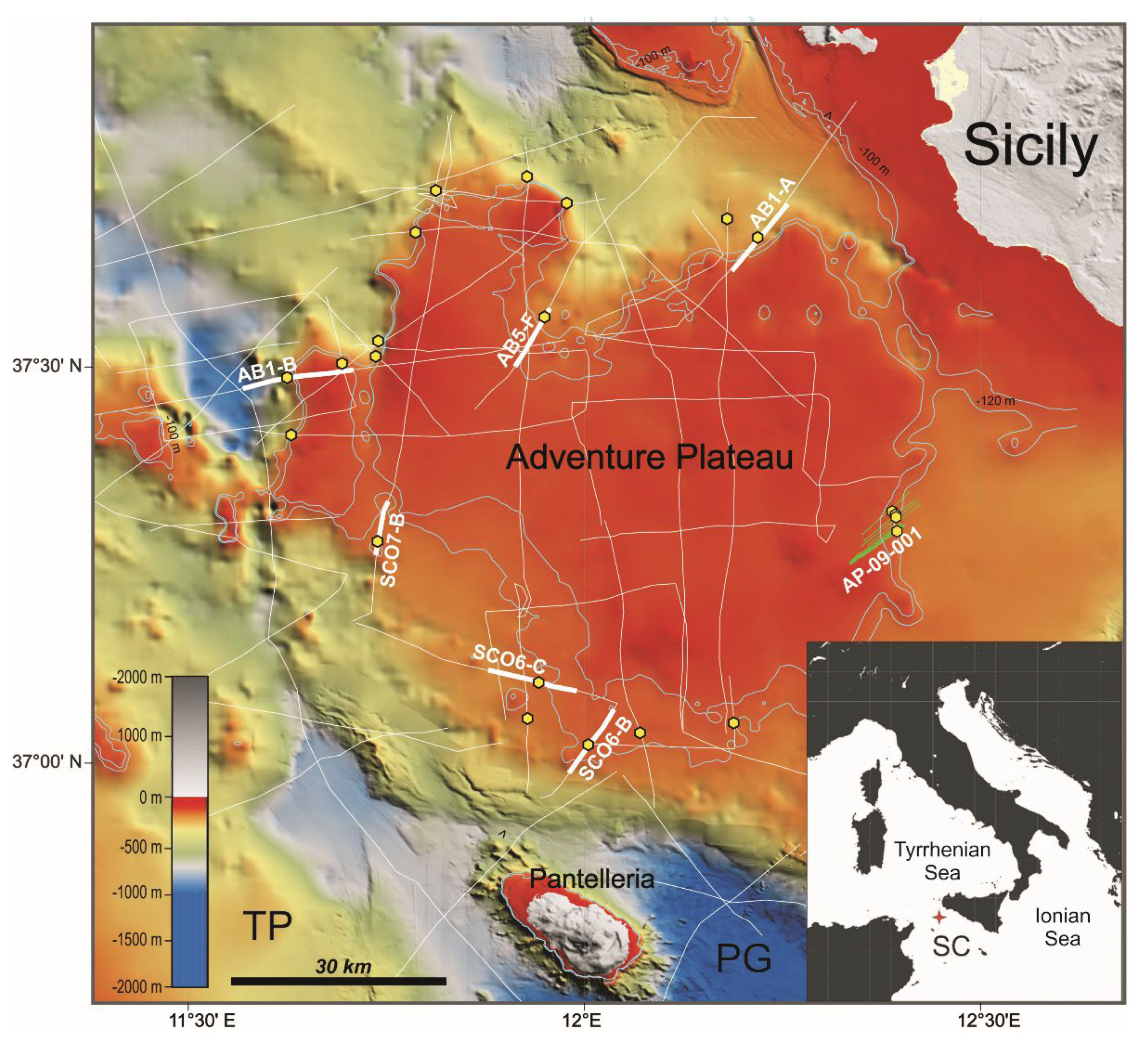
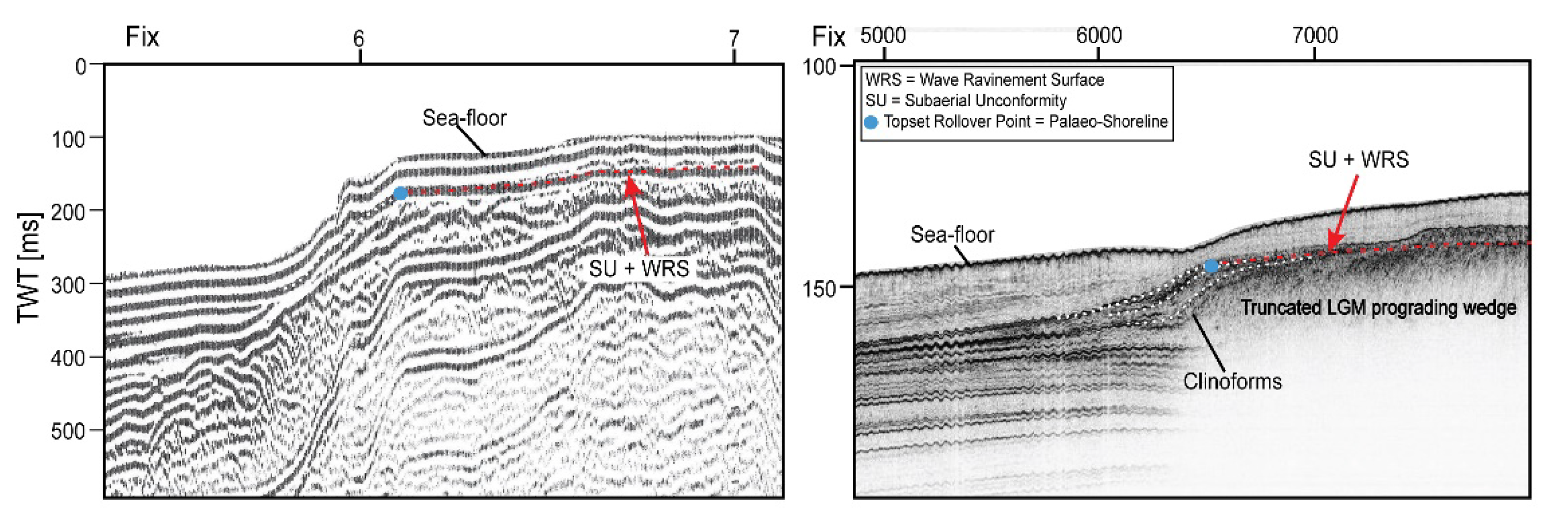
- By combining a series of recent and vintage high-resolution marine seismic profiles, the morphological elements linked to the LGM sea level fall in the Adventure Plateau (NW Sicilian Channel) were analyzed. This allowed us to map the palaeo-coastline at the LGM sea level minimum along the entire perimeter of the Adventure Plateau through the identification of the subaqueous clinoform rollover points composing the prograding wedges associated with the LGM sea level fall and the LGM erosional unconformities.
- In general, the analyzed geophysical data showed an extreme variability in the morphology of the margins of the Adventure Plateau: in some cases, the slope breaks of the plateau are very evident, and in other cases, the slope of the margin is extremely gentle instead, making the recognition of the markers related to the sea level minimum at the LGM more difficult.
- The mapped palaeo-coastline was then compared with the predictions derived from the GIA modeling, which considers the horizontal coastal migration in response to sea level rise. The two coastlines (i.e., the coastline derived from the interpretation of marine data and the one derived from the GIA modeling) are in good agreement at 21 kyears BP, with an average modeled palaeo-topography below the 1 m level. At 20 kyears BP, the model predicts an average palaeo-topography of −2.4 m, consistent with the post-LGM acceleration in the rate of sea level rise.
- The results of this study indicate the importance of comparing experimental data with model predictions to get a better picture of the evolution of sea level rise over various time scales.
Author Contributions
Funding
Institutional Review Board Statement
Informed Consent Statement
Data Availability Statement
Acknowledgments
Conflicts of Interest
References
- Clark, P.U.; Dyke, A.S.; Shakum, J.D.; Carlson, A.E.; Clark, J.; Wohlfarth, B.; Mitrovica, J.X.; Hostetler, S.W.; McCabe, A.M. The Last Glacial Maximum. Science 2009, 325, 710–714. [Google Scholar] [CrossRef] [PubMed] [Green Version]
- Peltier, W.R.; Fairbanks, R.G. Global Glacial Ice Volume and Last Glacial Maximum Duration from an Extended Barbados Sea Level Record. Quat. Sci. Rev. 2006, 25, 3322–3337. [Google Scholar] [CrossRef]
- Fairbanks, R. A 17,000-year glacio-eustatic sea level record: Influence of glacial melting rates on the Younger Dryas event and deep-ocean circulation. Nature 1989, 342, 637–642. [Google Scholar] [CrossRef]
- Liu, J.P.; Milliman, J.D. Reconsidering melt-water pulses 1A and 1B: Global impacts of rapid sea level rise. J. Oceanol. Univ. China 2004, 3, 183–190. [Google Scholar] [CrossRef]
- Deschamps, P.; Durand, N.; Bard, E.; Hamelin, B.; Camoin, G.; Thomas, A.L.; Henderson, G.M.; Okuno, J.; Yokoyama, Y. Ice-sheet collapse and sea level rise at the Bølling warming 14,600 years ago. Nature 2012, 483, 559–564. [Google Scholar] [CrossRef] [PubMed] [Green Version]
- Zecchin, M.; Ceramicola, S.; Lodolo, E.; Casalbore, D.; Chiocci, F.L. Episodic, rapid sea level rises on the central Mediterranean shelves after the Last Glacial Maximum: A review. Mar. Geol. 2015, 369, 212–223. [Google Scholar] [CrossRef]
- Brooke, B.P.; Nichol, S.L.; Huang, Z.; Beaman, R.J. Palaeoshorelines on the Australian continental shelf: Morphology, sea level relationship and applications to environmental management and archaeology. Cont. Shelf Res. 2017, 134, 26–38. [Google Scholar] [CrossRef]
- De Giosa, F.; Scardino, G.; Vacchi, M.; Piscitelli, A.; Milella, M.; Ciccolella, A.; Mastronuzzi, G. Geomorphological Signature of Late Pleistocene Sea Level Oscillations in Torre Guaceto Marine Protected Area (Adriatic Sea, SE Italy). Water 2019, 11, 2409. [Google Scholar] [CrossRef] [Green Version]
- Savini, A.; Bracchi, V.A.; Cammarosano, A.; Pennetta, M.; Russo, F. Terraced Landforms Onshore and Offshore the Cilento Promontory (South-Eastern Tyrrhenian Margin) and Their Significance as Quaternary Records of Sea Level Changes. Water 2021, 13, 566. [Google Scholar] [CrossRef]
- Civile, D.; Lodolo, E.; Alp, H.; Ben-Avraham, Z.; Cova, A.; Baradello, L.; Accettella, D.; Burca, M.; Centonze, J. Seismic stratigraphy and structural setting of the Adventure Plateau (Sicily Channel). Mar. Geophys. Res. 2014, 35, 37–53. [Google Scholar] [CrossRef]
- Colantoni, P.; Cremona, G.; Ligi, M.; Borsetti, A.M.; Cati, F. The Adventure Bank (off south-western Sicily): A present day example of carbonate shelf sedimentation. G. Geol. 1985, 47, 165–180. [Google Scholar]
- Calanchi, N.; Colantoni, P.; Rossi, P.L.; Saitta, M.; Serri, G. The Strait of Sicily continental rift systems: Physiography and petrochemistry of the submarine volcanic centers. Mar. Geol. 1989, 87, 55–83. [Google Scholar] [CrossRef]
- Lodolo, E.; Civile, D.; Zanolla, C.; Geletti, R. Magnetic signature of the Sicily Channel volcanism. Mar. Geophys. Res. 2012, 33, 33–44. [Google Scholar] [CrossRef]
- Lodolo, E.; Civile, D.; Zecchin, M.; Zampa, L.S.; Accaino, F. A series of volcanic edifices discovered a few kilometers off the coast of SW Sicily. Mar. Geol. 2019, 416, 105999. [Google Scholar] [CrossRef]
- Vai, G.B.; Cantelli, L. Litho-palaeoenvironmental maps of Italy during the last two climatic extremes: Map. 1—Last Glacial Maximum; Map. 2—Holocene climatic optimum, 1:1.000.000 scale. In Proceedings of the 32nd IGC Congress, Florence, Italy, 20–28 August 2004. [Google Scholar]
- Lodolo, E. When the Sicily Channel was an archipelago. Rend. Online Soc. Geol. Ital. 2012, 21, 1174–1175. [Google Scholar]
- Civile, D.; Lodolo, E.; Zecchin, M.; Ben-Avraham, Z.; Baradello, L.; Accettella, D.; Cova, A.; Caffau, M. The lost Adventure Archipelago (Sicilian Channel, Mediterranean Sea): Morpho-bathymetry and Late Quaternary palaeogeographic evolution. Glob. Planet. Change 2015, 125, 36–47. [Google Scholar] [CrossRef]
- Civile, D.; Lodolo, E.; Caffau, M.; Baradello, L.; Ben-Avraham, Z. Anatomy of a submerged archipelago in the Sicilian Channel (central Mediterranean Sea). Geol. Mag. 2016, 153, 160–178. [Google Scholar] [CrossRef]
- Maldonado, A.; Stanley, D.A. Lithofacies as a function of depth in the Strait of Sicily. Geology 1977, 5, 111–117. [Google Scholar] [CrossRef]
- Stanley, D.A.; Maldonado, A.; Stuckenrath, R. Strait of Sicily depositional rates and patterns, and possible reversals of currents in the Late Quaternary. Palaeogeogr. Palaeoclimatol. Palaeoecol. 1975, 18, 279–291. [Google Scholar] [CrossRef]
- Ferranti, L.; Antonioli, F.; Mauz, B.; Amorosi, A.; Dai Pra, G.; Mastronuzzi, G.; Monaco, C.; Orrù, P.; Pappalardo, M.; Radtke, U.; et al. Markers of the last interglacial sea level high stand along the coast of Italy: Tectonic implications. Quat. Int. 2006, 145, 30–54. [Google Scholar] [CrossRef]
- Antonioli, F.; Ferranti, L.; Fontana, A.; Amorosi, A.; Bondesan, A.; Braitenberg, C.; Dutton, A.; Fontolan, G.; Furlani, S.; Lambeck, K.; et al. Holocene relative sea level changes and vertical movements along the Italian and Istrian coastlines. Quat. Int. 2009, 206, 102–133. [Google Scholar] [CrossRef]
- Serpelloni, E.; Anzidei, M.; Baldi, P.; Casula, G.; Galvani, A. Crustal velocity and strain-rate fields in Italy and surrounding regions: New results from the analysis of permanent and non-permanent GPS networks. Geophys. J. Int. 2005, 161, 861–880. [Google Scholar] [CrossRef] [Green Version]
- Lodolo, E.; Galassi, G.; Spada, G.; Zecchin, M.; Civile, D.; Bressou, M. Post-LGM coastline evolution of the NW Sicilian Channel: Comparing high-resolution geophysical data with Glacial Isostatic Adjustment modeling. PLoS ONE 2020, 15, e0228087. [Google Scholar] [CrossRef] [PubMed]
- Ferranti, L.; Pepe, F.; Barreca, G.; Meccariello, M.; Monaco, C. Multi-temporal tectonic evolution of Capo Granitola and Sciacca foreland transcurrent faults (Sicily Channel). Tectonophysics 2019, 765, 187–204. [Google Scholar] [CrossRef]
- Civile, D.; Lodolo, E.; Accaino, F.; Geletti, R.; Schiattarella, M.; Giustiniani, M.; Fedorik, J.; Zecchin, M.; Zampa, L. Capo Granitola-Sciacca Fault Zone (Sicilian Channel, Central Mediterranean): Structure vs magmatism. Mar. Pet. Geol. 2018, 96, 627–644. [Google Scholar] [CrossRef]
- Civile, D.; Brancolini, G.; Lodolo, E.; Forlin, E.; Accaino, F.; Zecchin, M.; Brancatelli, G. Morphostructural Setting and Tectonic Evolution of the Central Part of the Sicilian Channel (Central Mediterranean). Lithosphere 2021, 2021, 7866771. [Google Scholar] [CrossRef]
- Fedorik, J.; Toscani, G.; Lodolo, E.; Civile, D.; Bonini, L.; Seno, S. Structural analysis and Miocene-to-Present tectonic evolution of a lithospheric-scale, transcurrent lineament: The Sciacca Fault (Sicilian Channel, Central Mediterranean Sea). Tectonophysics 2018, 722, 342–355. [Google Scholar] [CrossRef]
- Colantoni, P.; Del Monte, M.; Gallignani, P.; Zarudzky, E.F.K. Il Banco Graham: Un vulcano recente nel Canale di Sicilia. G. Geol. 1975, 40, 141–162. [Google Scholar]
- Farran, M. Una aplicación informática para la conversión de imágenes de perfiles sísmicos a ficheros en formato SEG Y. Geo-Temas 2008, 10, 1215–1218. [Google Scholar]
- Catuneanu, O. Principles of Sequence Stratigraphy; Elsevier: Amsterdam, The Netherlands, 2006; p. 386. [Google Scholar]
- Patruno, S.; Helland-Hansen, W. Clinoforms and clinoform systems: Review and dynamic classification scheme for shorelines, subaqueous deltas, shelf edges and continental margins. Earth-Sci. Rev. 2018, 185, 202–233. [Google Scholar] [CrossRef]
- Zecchin, M.; Catuneanu, O.; Caffau, M. Wave-ravinement surfaces: Classification and key characteristics. Earth-Sci. Rev. 2019, 188, 210–239. [Google Scholar] [CrossRef]
- Spada, G.; Melini, D. SELEN4 (SELEN version 4.0): A Fortran program for solving the gravitationally and topographically self-consistent Sea Level Equation in Glacial Isostatic Adjustment modeling. Geosci. Model Dev. Discuss. 2019, 12, 5055–5075. [Google Scholar] [CrossRef] [Green Version]
- Farrell, W.E.; Clark, J.A. On postglacial sea level. Geophys. J. R. Astron. Soc. 1976, 46, 647–667. [Google Scholar] [CrossRef]
- Mitrovica, J.X.; Milne, G.A. On postglacial sea level: I. Gen. Theory. Geophys. J. Int. 2003, 154, 253–267. [Google Scholar] [CrossRef] [Green Version]
- Roy, K.; Peltier, W.R. Glacial isostatic adjustment, relative sea level history and mantle viscosity: Reconciling relative sea level model predictions for the US East coast with geological constraints. Geophys. J. Int. 2015, 201, 1156–1181. [Google Scholar] [CrossRef]
- Roy, K.; Peltier, W.R. Space-geodetic and water level gauge constraints on continental uplift and tilting over North America: Regional convergence of the ICE-6G_C (VM5a/VM6) models. Geophys. J. Int. 2017, 210, 1115–1142. [Google Scholar] [CrossRef]
- Roy, K.; Peltier, W.R. Relative sea level in the Western Mediterranean basin: A regional test of the ICE-7G_NA (VM7) model and a constraint on Late Holocene Antarctic deglaciation. Quat. Sci. Rev. 2018, 183, 76–87. [Google Scholar] [CrossRef]
- Amante, C.; Eakins, B. ETOPO1 Arc-Minute Global Relief Model: Procedures, Data Source and Analysis; NOAA Technical Memorandum NESDIS NGDC-2; National Geophysical Data Center: Boulder, CO, USA, 2009; pp. 1–19. [Google Scholar]
- Cattaneo, A.; Steel, R.J. Transgressive deposits: A review of their variability. Earth-Sci. Rev. 2003, 62, 187–228. [Google Scholar] [CrossRef]
- Spada, G.; Melini, D. New estimates of ongoing sea level change and land movements caused by Glacial Isostatic Adjustment in the Mediterranean region. Geophys. J. Int. 2021, 229, 984–998. [Google Scholar] [CrossRef]
- Lambeck, K.; Purcell, A.W. Sea level change in the Mediterranean Sea since the LGM: Model predictions for tectonically stable areas. Quat. Sci. Rev. 2005, 34, 1969–1988. [Google Scholar] [CrossRef]


Publisher’s Note: MDPI stays neutral with regard to jurisdictional claims in published maps and institutional affiliations. |
© 2022 by the authors. Licensee MDPI, Basel, Switzerland. This article is an open access article distributed under the terms and conditions of the Creative Commons Attribution (CC BY) license (https://creativecommons.org/licenses/by/4.0/).
Share and Cite
Lodolo, E.; Loreto, M.F.; Melini, D.; Spada, G.; Civile, D. Palaeo-Shoreline Configuration of the Adventure Plateau (Sicilian Channel) at the Last Glacial Maximum. Geosciences 2022, 12, 125. https://doi.org/10.3390/geosciences12030125
Lodolo E, Loreto MF, Melini D, Spada G, Civile D. Palaeo-Shoreline Configuration of the Adventure Plateau (Sicilian Channel) at the Last Glacial Maximum. Geosciences. 2022; 12(3):125. https://doi.org/10.3390/geosciences12030125
Chicago/Turabian StyleLodolo, Emanuele, Maria Filomena Loreto, Daniele Melini, Giorgio Spada, and Dario Civile. 2022. "Palaeo-Shoreline Configuration of the Adventure Plateau (Sicilian Channel) at the Last Glacial Maximum" Geosciences 12, no. 3: 125. https://doi.org/10.3390/geosciences12030125


