

Nisyros Aspiring UNESCO Global Geopark: Crucial Steps for Promoting the Volcanic Landscape’s Unique Geodiversity

 ,
, 
 ,
, 
 ,
, 
Abstract
:1. Introduction
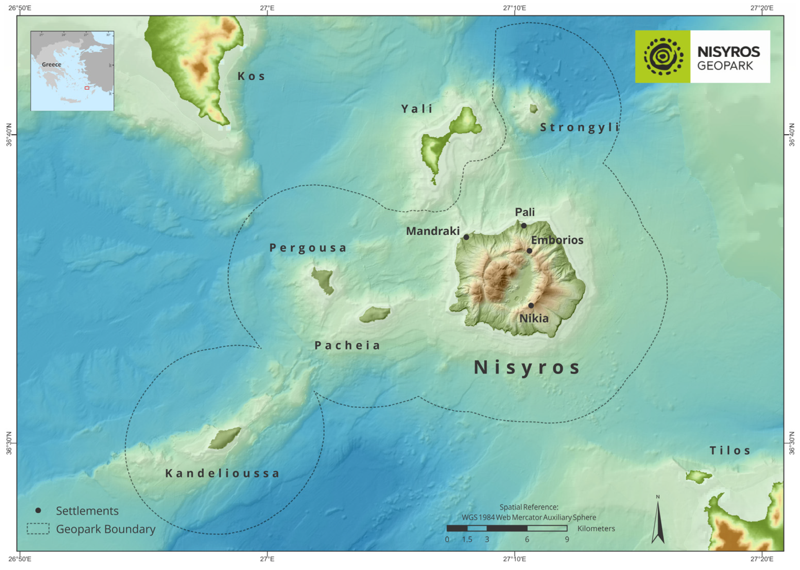
2. Nisyros Aspiring UNESCO Global Geopark

3. Materials and Methods
4. Results
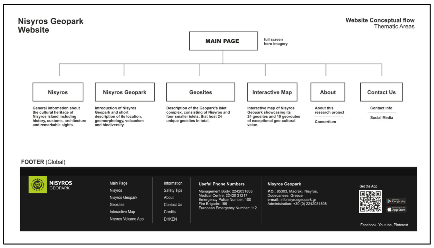
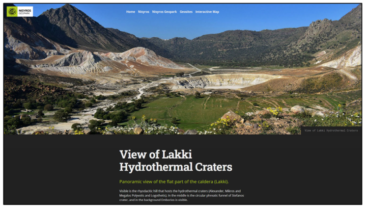
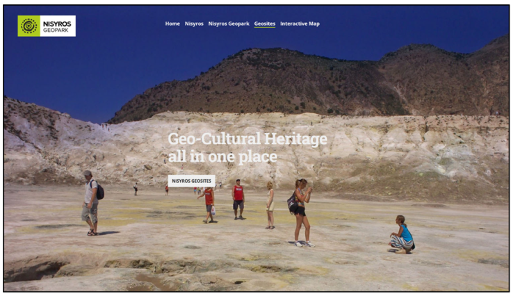
4.1. Website
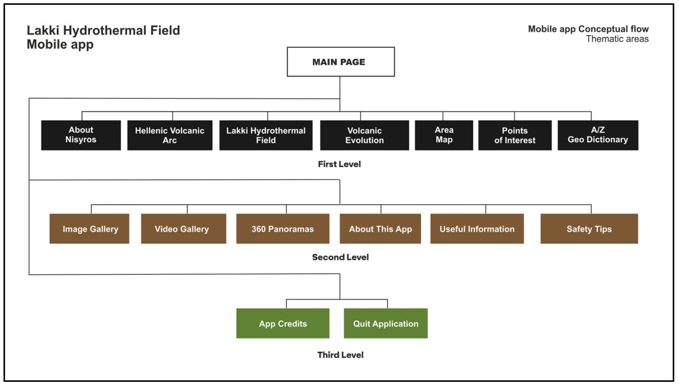
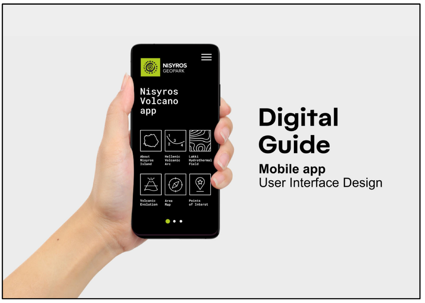
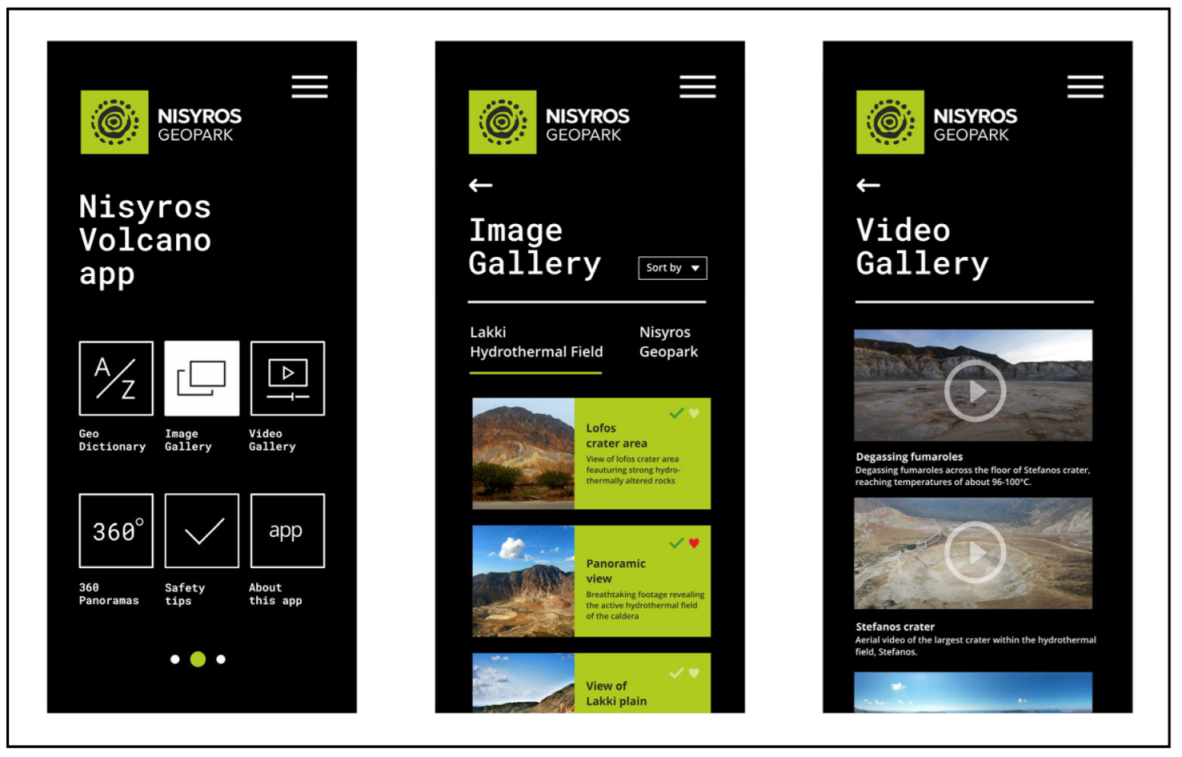
4.2. Nisyros Volcano App
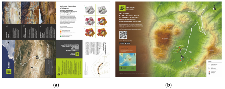
4.3. Leaflet
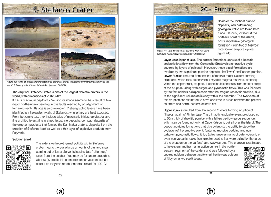
4.4. Guidebook
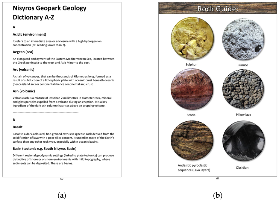
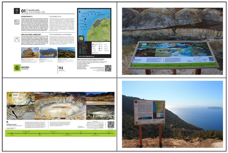
4.5. Panels—Signs
5. Discussion
6. Conclusions
Author Contributions
Funding
Data Availability Statement
Acknowledgments
Conflicts of Interest
References
- Dowling, R.K. Global Geotourism—An Emerging Form of Sustainable Tourism. Czech J. Tour. 2014, 2, 59–79. [Google Scholar] [CrossRef] [Green Version]
- Fassoulas, C.; Nikolakakis, E.; Staridas, S. Digital Tools to Serve Geotourism and Sustainable Development at Psiloritis UNESCO Global Geopark in COVID Times and Beyond. Geosciences 2022, 12, 78. [Google Scholar] [CrossRef]
- Stolz, J.; Megerle, H.E. Geotrails as a Medium for Education and Geotourism: Recommendations for Quality Improvement Based on the Results of a Research Project in the Swabian Alb UNESCO Global Geopark. Land 2022, 11, 1422. [Google Scholar] [CrossRef]
- Farsani, N.T.; Coelho, C.; Costa, C. Geotourism and geoparks as novel strategies for socio-economic development in rural areas. Int. J. Tour. Res. 2011, 13, 68–81. [Google Scholar] [CrossRef]
- Zouros, N. Global Geoparks Network and The New Unesco Global Geoparks Programme. Bull. Geol. Soc. Greece 2017, 50, 284–292. [Google Scholar] [CrossRef] [Green Version]
- Gordon, J.E. Geoheritage, Geotourism and the Cultural Landscape: Enhancing the Visitor Experience and Promoting Geoconservation. Geosciences 2018, 8, 136. [Google Scholar] [CrossRef] [Green Version]
- Antoniou, V.; Nomikou, P.; Panousis, D.; Zafeirakopoulou, E. Nisyros Volcanic Island: A Geosite through a Tailored GIS Story. Geosciences 2021, 11, 132. [Google Scholar] [CrossRef]
- Catana, M.M.; Brilha, J.B. The Role of UNESCO Global Geoparks in Promoting Geosciences Education for Sustainability. Geoheritage 2020, 12, 1. [Google Scholar] [CrossRef]
- Giardino, M.; Justice, S.; Olsbo, R.; Balzarini, P.; Magagna, A.; Viani, C.; Selvaggio, I.; Kiuttu, M.; Kauhanen, J.; Laukkanen, M.; et al. ERASMUS+ Strategic Partnerships between UNESCO Global Geoparks, Schools, and Research Institutions: A Window of Opportunity for Geoheritage Enhancement and Geoscience Education. Heritage 2022, 5, 677–701. [Google Scholar] [CrossRef]
- Xu, K.; Wu, W. Geoparks and Geotourism in China: A Sustainable Approach to Geoheritage Conservation and Local Development—A Review. Land 2022, 11, 1493. [Google Scholar] [CrossRef]
- UNESCO (United Nations Educational, Scientific and Cultural Organization). UNESCO Global Geoparks. Celebrating Earth Heritage, Sustaining Local Communities; UNESCO: Paris, France, 2016; pp. 3–13. [Google Scholar]
- UNESCO. Geoparks Fundamental Features. Available online: https://en.unesco.org/global-geoparks/focus#fundamental (accessed on 21 December 2022).
- Martini, B.G.; Zouros, N.; Zhang, J.; Jin, X.; Komoo, I.; Border, M.; Watanabe, M.; Frey, M.L.; Rangnes, K.; Van, T.T.; et al. UNESCO Global Geoparks in the "World after": A multiplegoals roadmap proposal for future discussion. Episodes 2021, 45, 29–35. [Google Scholar] [CrossRef] [PubMed]
- UNESCO. Statutes of the International Geoscience and Geoparks Programme (IGCP). Available online: https://unesdoc.unesco.org/ark:/48223/pf0000234539.locale=en (accessed on 10 December 2022).
- Zouros, N.; Rangnes, K. The European Geoparks Network: Operation and Procedures. Schriftenr. Dt. Ges. Geowiss. 2016, 88, 31–36. [Google Scholar] [CrossRef]
- UNESCO. List of UNESCO Global Geoparks. Available online: https://en.unesco.org/global-geoparks/list#list (accessed on 21 December 2022).
- Rosado-González, E.M.; Sá, A.A.; Palacio-Prieto, J.L. UNESCO Global Geoparks in Latin America and the Caribbean, and Their Contribution to Agenda 2030 Sustainable Development Goals. Geoheritage 2020, 12, 1–15. [Google Scholar] [CrossRef]
- United Nations. Transforming Our World: The 2030 Agenda for Sustainable Development; United Nations: New York, NY, USA; Available online: https://sdgs.un.org/2030agenda (accessed on 21 December 2022).
- Gill, J.C. Geology and the Sustainable Development Goals. Episodes 2017, 40, 70–76. [Google Scholar] [CrossRef]
- Cayla, N. An Overview of New Technologies Applied to the Management of Geoheritage. Geoheritage 2014, 6, 91–102. [Google Scholar] [CrossRef]
- Aldighieri, B.; Testa, B.; Bertini, A. 3D Exploration of the San Lucano Valley: Virtual Geo-routes for Everyone Who Would Like to Understand the Landscape of the Dolomites. Geoheritage 2016, 8, 77–90. [Google Scholar] [CrossRef]
- Kim, H.-S.; Lim, C. Developing a geologic 3D panoramic virtual geological field trip for Mudeung UNESCO global geopark, South Korea. Episodes 2019, 42, 235–244. [Google Scholar] [CrossRef] [Green Version]
- Perotti, L.; Bollati, I.M.; Viani, C.; Zanoletti, E.; Caironi, V.; Pelfini, M.; Giardino, M. Fieldtrips and Virtual Tours as Geotourism Resources: Examples from the Sesia Val Grande UNESCO Global Geopark (NW Italy). Resources 2020, 9, 63. [Google Scholar] [CrossRef]
- Williams, M.; McHenry, M. The Increasing Need for Geographical Information Technology (GIT) tools in Geoconservation and Geotourism. Geoconservation Res. 2020, 3, 17–32. [Google Scholar] [CrossRef]
- Gambino, F.; Borghi, A.; D’Atri, A.; Gallo, L.M.; Ghiraldi, L.; Giardino, M.; Martire, L.; Palomba, M.; Perotti, L.; Macadam, J. TOURinSTONES: A Free Mobile Application for Promoting Geological Heritage in the City of Torino (NW Italy). Geoheritage 2019, 11, 3–17. [Google Scholar] [CrossRef]
- Papanikolaou, D.; Nomikou, P. Tectonic structure and volcanic centers at the eastern edge of the aegean volcanic arc around Nisyros island. Bull. Geol. Soc. Greece 2001, 34, 289–296. [Google Scholar] [CrossRef]
- Nomikou, P.; Papanikolaou, D.; Alexandri, M.; Sakellariou, D.; Rousakis, G. Submarine volcanoes along the Aegean volcanic arc. Tectonophysics 2013, 597–598, 123–146. [Google Scholar] [CrossRef]
- Allen, S.R. Volcanology of the Kos Plateau Tuff, Greece: The Product of An Explosive Eruption in An Archipelago. Ph.D. Thesis, Monash University, Melbourne, Australia, 1998. [Google Scholar]
- Allen, S.R.; Stadlbauer, E.; Keller, J. Stratigraphy of the Kos Plateau Tuff: Product of a major Quaternary explosive rhyolitic eruption in the eastern Aegean, Greece. Int. J. Earth Sci. 1999, 88, 132–156. [Google Scholar] [CrossRef]
- Allen, S. Reconstruction of a major caldera-forming eruption from pyroclastic deposit characteristics: Kos Plateau Tuff, eastern Aegean Sea. J. Volcanol. Geotherm. Res. 2001, 105, 141–162. [Google Scholar] [CrossRef]
- Nomikou, P. Contribution to The Geodynamics of the Dodecanese: The Submarine Area of Kos-Nisyros Islands. Ph.D. Thesis, National and Kapodistrian University of Athens, Greece, 2004. (In Greek). [Google Scholar]
- Pe-Piper, G.; Piper, D.J.; Perissoratis, C. Neotectonics and the Kos Plateau Tuff eruption of 161 ka, South Aegean arc. J. Volcanol. Geotherm. Res. 2005, 139, 315–338. [Google Scholar] [CrossRef]
- Dietrich, V.J. Geology of Nisyros Volcano. In Nisyros Volcano, 1st ed; Dietrich, V.J., Lagios, E., Eds.; Springer International Publishing: Cham, Switzerland, 2018; pp. 57–102. [Google Scholar] [CrossRef]
- Pe-Piper, G.; Piper, D.J.W. The Igneous Rocks of Greece. The Anatomy of an Orogen. Geol. Mag. 2003, 140, 357. [Google Scholar] [CrossRef]
- Nomikou, P.; Papanikolaou, D. Extension of active fault zones on Nisyros volcano across the Yali-Nisyros Channel based on onshore and offshore data. Mar. Geophys. Res. 2011, 32, 181–192. [Google Scholar] [CrossRef]
- Tibaldi, A.; Pasquarè, F.; Papanikolaou, D.; Nomikou, P. Tectonics of Nisyros Island, Greece, by field and offshore data, and analogue modelling. J. Struct. Geol. 2008, 30, 1489–1506. [Google Scholar] [CrossRef]
- Nomikou, P.; Papanikolaou, D.; Dietrich, V.J. Geodynamics and Volcanism in the Kos-Yali-Nisyros Volcanic Field. In Nisyros Volcano, 1st ed; Dietrich, V.J., Lagios, E., Eds.; Springer International Publishing: Cham, Switzerland, 2018; pp. 13–55. [Google Scholar] [CrossRef]
- Di Paola, G.M. Volcanology and petrology of Nisyros Island (Dodecanese, Greece). Bull. Volcanol. 1974, 38, 944–987. [Google Scholar] [CrossRef]
- Innocenti, F.; Manetti, P.; Peccerillo, A.; Poli, G. South Aegean volcanic arc: Geochemical variations and geotectonic implications. Bull. Volcanol. 1981, 44, 377–391. [Google Scholar] [CrossRef]
- Makris, J.; Stobbe, C. Physical properties and state of the crust and upper mantle of the Eastern Mediterranean Sea deduced from geophysical data. Mar. Geol. 1984, 55, 345–361. [Google Scholar] [CrossRef]
- Papanikolaou, D.; Lekkas, E.; Sakellariou, D. Geological structure and evolution of the Nisyros volcano. Bull. Geol. Soc. Greece 1991, 25, 405–419. [Google Scholar]
- Volentik, A.; Vanderkluysen, L.; Principe, C.; Hunziker, J.C. Stratigraphy of Nisyros volcano (Greece). In The Petrology and Geochemistry of Lavas and Tephras of Nisyros Volcano (Greece); Hunziker, J.C., Marini, L., Eds.; Mémoires de Géologie: Lausanne, Switzerland, 2005; Volume 44, pp. 26–66. Available online: https:s//www.researchgate.net/publication/236611984_Stratigraphy_of_Nisyros_Volcano_Greece (accessed on 10 December 2022).
- Royden, L.H.; Papanikolaou, D.J. Slab segmentation and late Cenozoic disruption of the Hellenic arc. Geochem. Geophys. Geosystems 2011, 12, Q03010. [Google Scholar] [CrossRef]
- Dietrich, V.; Lagios, E. Nisyros Volcano, 1st ed.; Springer International Publishing: Cham, Switzerland, 2018. [Google Scholar] [CrossRef]
- Papadimitriou, P.; Karakonstantis, A.; Kapetanidis, V.; Bozionelos, G.; Kaviris, G.; Voulgaris, N. Seismicity and Tomographic Imaging of the Broader Nisyros Region (Greece). In Nisyros Volcano, 1st ed.; Dietrich, V.J., Lagios, E., Eds.; Springer International Publishing: Cham, Switzerland, 2018; pp. 245–271. [Google Scholar] [CrossRef]
- Papoulia, J.; Makris, J.; Koulakov, I.; Fasoulaka, C.; Drakopoulou, P. Microseismicity and Crustal Deformation of the Dodecanese Volcanic Area, Southeastern Aegean Sea Using an Onshore/Offshore Seismic Array. In Nisyros Volcano, 1st ed.; Dietrich, V.J., Lagios, E., Eds.; Springer International Publishing: Cham, Switzerland, 2018; pp. 273–284. [Google Scholar] [CrossRef]
- Parcharidis, I.; Lagios, E.; Sakkas, V. Differential Interferometry as a Tool of An Early Warning System in Reducing The Volcano Risk: The Case of Nisyros Volcano. Bull. Geol. Soc. Greece 2018, 36, 913–918. [Google Scholar] [CrossRef]
- Tompolidi, A.-M.; Parcharidis, I.; Sykioti, O. Investigation of Sentinel-1 capabilities to detect hydrothermal alteration based on multitemporal interferometric coherence: The case of Nisyros volcano (Greece). Procedia Comput. Sci. 2021, 181, 1027–1033. [Google Scholar] [CrossRef]
- Nomikou, P.; Krassakis, P.; Kazana, S.; Papanikolaou, D.; Koukouzas, N. The Volcanic Relief within the Kos-Nisyros-Tilos Tectonic Graben at the Eastern Edge of the Aegean Volcanic Arc, Greece and Geohazard Implications. Geosciences 2021, 11, 231. [Google Scholar] [CrossRef]
- Chalkiadakis, N. Volcanic Risk Management at The Nisyros Volcano. Bachelor’s Thesis, National and Kapodistrian University of Athens, Greece. Available online: https://pergamos.lib.uoa.gr/uoa/dl/object/2946922 (accessed on 10 December 2022).
- Chartofili, A. Digital Games in Education: Development and Evaluation of an Interactive Game for Teaching and Enhancing the Location Knowing of Nisyros for Secondary and High School Students. Master’s Thesis, University of the Aegean, Greece. Available online: http://hdl.handle.net/11610/18832 (accessed on 10 December 2022).
- Chatzifoti, E. Nisyros Volcano: Volcanic Risk Management and Risk. Bachelor’s Thesis, National and Kapodistrian University of Athens, Greece. Available online: https://pergamos.lib.uoa.gr/uoa/dl/object/1317943 (accessed on 10 December 2022).
- Dietrich, V.J. Epilogue Nisyros Island, The Inaccessible Outpost Between Orient and Occident, Home of a Restless Giant. In Nisyros Volcano, 1st ed.; Dietrich, V.J., Lagios, E., Eds.; Springer International Publishing: Cham, Switzerland, 2018; pp. 321–336. [Google Scholar] [CrossRef]
- Liritzis, I.; Oikonomou, A. An updated overview of archaeological sciences research in insular Greek Aegean islands. Mediterr. Archaeol. Archaeom. 2021, 21, 1–27. [Google Scholar] [CrossRef]
- Liritzis, I.; Michael, C.; Galloway, R.B. A significant aegean volcanic eruption during the second millennium B.C. revealed by thermoluminescence dating. Geoarchaeology 1996, 11, 361–371. [Google Scholar] [CrossRef]
- Galloway, R.B.; Liritzis, Y. Provenance of Aegean volcanic tephras by high resolution gamma-ray spectrometry. Nucl. Geophys. 1992, 6, 405. [Google Scholar]


Disclaimer/Publisher’s Note: The statements, opinions and data contained in all publications are solely those of the individual author(s) and contributor(s) and not of MDPI and/or the editor(s). MDPI and/or the editor(s) disclaim responsibility for any injury to people or property resulting from any ideas, methods, instructions or products referred to in the content. |
© 2023 by the authors. Licensee MDPI, Basel, Switzerland. This article is an open access article distributed under the terms and conditions of the Creative Commons Attribution (CC BY) license (https://creativecommons.org/licenses/by/4.0/).
Share and Cite
Nomikou, P.; Panousis, D.; Nikoli, E.; Antoniou, V.; Emmanouloudis, D.; Pehlivanides, G.; Agiomavritis, M.; Nastos, P.; Cieslak-Jones, E.; Batis, A. Nisyros Aspiring UNESCO Global Geopark: Crucial Steps for Promoting the Volcanic Landscape’s Unique Geodiversity. Geosciences 2023, 13, 70. https://doi.org/10.3390/geosciences13030070
Nomikou P, Panousis D, Nikoli E, Antoniou V, Emmanouloudis D, Pehlivanides G, Agiomavritis M, Nastos P, Cieslak-Jones E, Batis A. Nisyros Aspiring UNESCO Global Geopark: Crucial Steps for Promoting the Volcanic Landscape’s Unique Geodiversity. Geosciences. 2023; 13(3):70. https://doi.org/10.3390/geosciences13030070
Chicago/Turabian StyleNomikou, Paraskevi, Dimitrios Panousis, Elisavet Nikoli, Varvara Antoniou, Dimitrios Emmanouloudis, Georgios Pehlivanides, Marios Agiomavritis, Panagiotis Nastos, Emma Cieslak-Jones, and Aris Batis. 2023. "Nisyros Aspiring UNESCO Global Geopark: Crucial Steps for Promoting the Volcanic Landscape’s Unique Geodiversity" Geosciences 13, no. 3: 70. https://doi.org/10.3390/geosciences13030070
APA StyleNomikou, P., Panousis, D., Nikoli, E., Antoniou, V., Emmanouloudis, D., Pehlivanides, G., Agiomavritis, M., Nastos, P., Cieslak-Jones, E., & Batis, A. (2023). Nisyros Aspiring UNESCO Global Geopark: Crucial Steps for Promoting the Volcanic Landscape’s Unique Geodiversity. Geosciences, 13(3), 70. https://doi.org/10.3390/geosciences13030070