Abstract
Feni is located at the southeastern end of the NW-trending Tabar–Lihir–Tanga–Feni (TLTF) volcanic island chain, in northeastern Papua New Guinea. This island chain is renowned for hosting alkaline volcanics, geothermal activity, copper–gold mineralization, and mining. There is no agreed consensus on the tectonic and petrogenetic evolution of Feni. Thus, the purpose of our paper is to present the geology of Feni within the context of the regional tectonic evolution of the TLTF chain and offer a succinct and generic geodynamic model that sets the stage for our next paper. The methodologies used in this study include a critical review of published and unpublished literature in conjunction with our geological observations on Feni. The Pliocene-to-Holocene TLTF chain is a younger arc situated within the greater Eocene-to-Oligocene Melanesian Arc bounded by New Ireland to the west, the Kilinailau Trench and Ontong Java Plateau in the east, and the New Britain Trench to the south. The geological units mapped on Feni include a large volume of basaltic lava flow and trachyandesite stocks intruding a limestone and siltstone basement. Younger units include the trachyte domes, pyroclastic flow, and ash fall deposits. The major structures on Feni are normal or extensional faults such as the Niffin Graben. Feni magmatism is attributed to the petrogenetic processes of polybaric or decompression melting and crystal fractionation of magmas previously influenced by sediment assimilation, mantle wedge metasomatism, slab tears, slab melts, and subduction. Deep lithospheric normal faults provide the fluid pathways for the Feni alkaline magmas.
1. Introduction
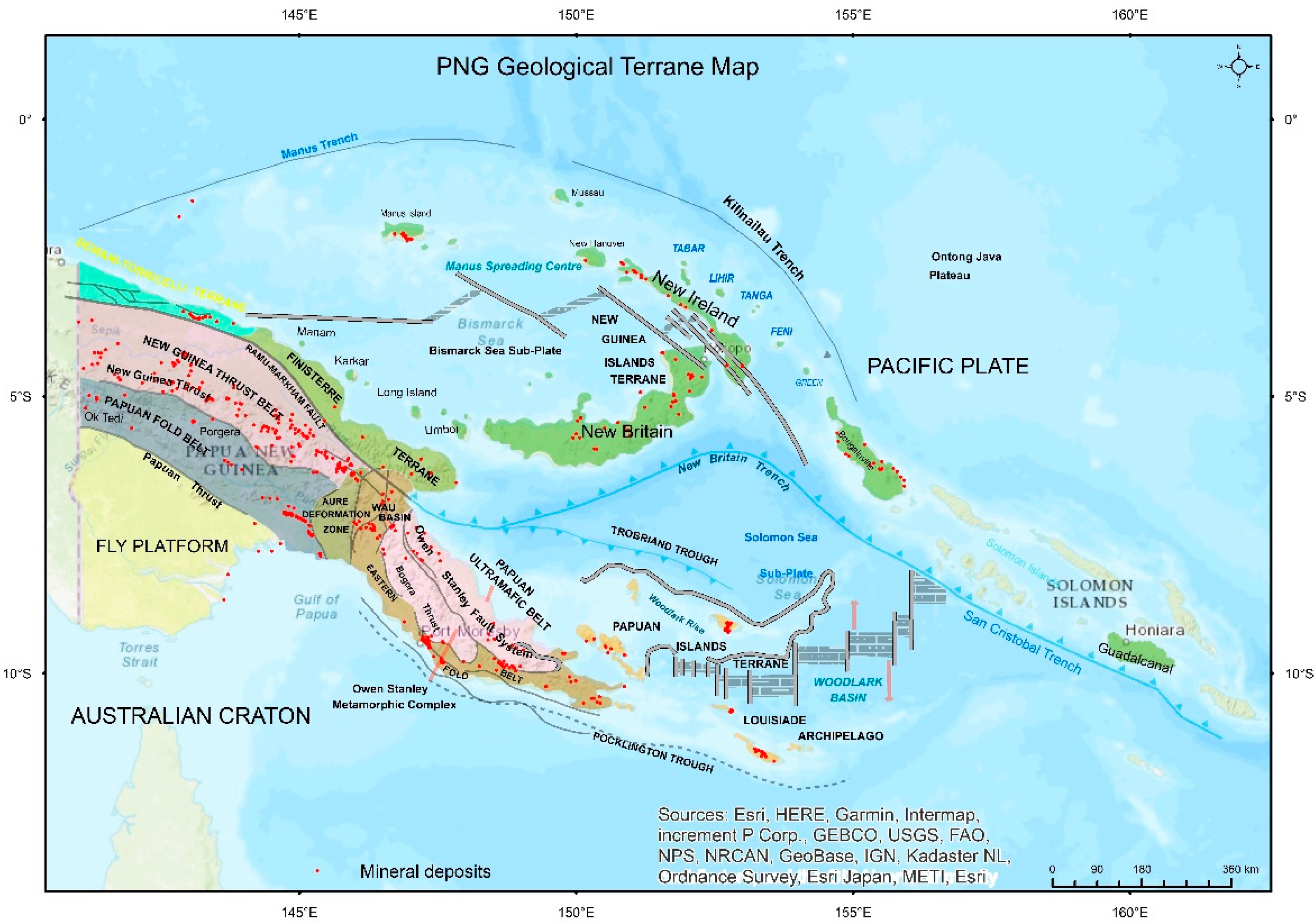
Papua New Guinea (PNG), located within the island of New Guinea, north of Australia, is a geologically and tectonically complex country comprising several unique geotectonic terranes [1]. PNG’s territory includes: (1) the eastern side of New Guinea (or PNG mainland), and (2) the smaller islands of the Melanesian Arc or New Guinea Islands Terrane including New Britain, New Ireland, Manus, and Bougainville (Figure 1). The basement rocks of mainland PNG or eastern New Guinea include Palaeozoic-to-Mesozoic metamorphic, intrusive, and volcanic units [2,3]. Ultramafic and ophiolite sequences of Palaeocene age were subsequently accreted onto the basement rocks of mainland New Guinea to form the Papuan Ultramafics, Marum Ophiolite, and April Ophiolite [3,4]. In contrast, the islands of the Melanesian Arc are underlain by Eocene-to-Oligocene basement volcanic units [5]. Our area of study is the Feni Island Group situated east of New Ireland (Figure 1 and Figure 2). It is defined by Pleistocene-to-Holocene alkaline volcanics and volcaniclastics built on siltstone and Oligocene limestone [6].
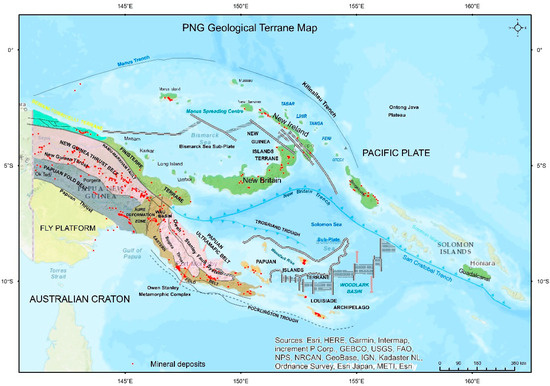
Figure 1.
PNG geotectonic terrane map modified after Williamson & Hancock [1].
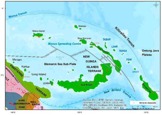
Figure 2.
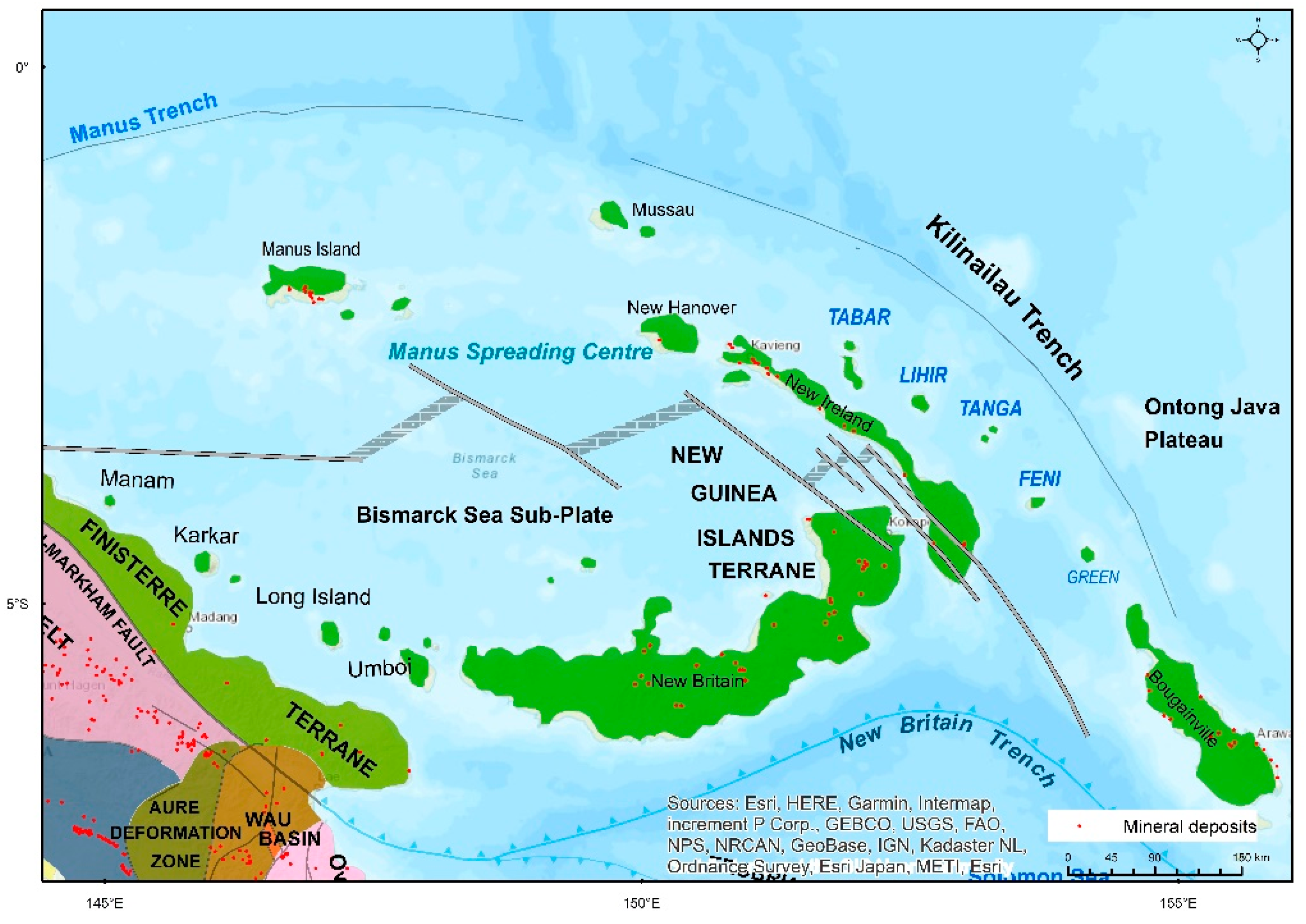
Location of the TLTF islands within the New Guinea Islands Terrane relative to the Kilinailau Trench, Ontong Java Plateau, New Britain Trench, and the Schouten Island Group. Modified after Williamson & Hancock [1].
The Feni Island Group is part of the Tabar–Lihir–Tanga–Feni (TLTF) volcanic chain within the New Ireland Basin (NIB), New Ireland Province (NIP), northeast PNG. Feni consists of Babase and Ambitle islands located between geographic coordinates 3°45′ S, 153°30′ E and 4°15′ S, 154°00′ E, forming the southern end of the Pliocene-to-Holocene alkaline TLTF volcanic island chain (Figure 1 and Figure 2). This review article is a prelude to our sister paper also published in this Special Issue titled “The petrology and geochemistry of the REE- enriched, alkaline volcanic rocks of Feni Island group, Papua New Guinea”. The aim of our paper is to (1) summarize the main concepts with respect to PNG’s geotectonic evolution, particularly focusing on the New Guinea Islands Terrane and the TLTF chain, (2) discuss the geology of Feni and its petrological history, and (3) offer a succinct geodynamic model.
2. Geology and Tectonic Setting of Papua New Guinea
The geological history of PNG is relatively young and highly complex with multiple stages of tectonic activity and associated magmatic and deformational events. New Guinea is situated at the active boundaries of the north-moving Indo-Australian Plate and the NW-moving Pacific Plate. Island arcs occur above the subducting Australian Plate and include the arcs of the PNG islands, Solomon Islands, Vanuatu, and Tonga [7]. The Australian Plate is moving north at 7 cm per year whilst the Pacific Plate is moving west–northwest at a rate of 10–11 cm per year [8,9]. The collision of these plates within PNG results in a convergence to the east–northeast (070°) at a rate of 11 cm per year [3].
Papua New Guinea (Figure 1) is made up of several terranes classified into four main geotectonic provinces [1,10,11,12]:
- (1)
- Stable Fly Platform
- (2)
- New Guinea Orogen
- (3)
- Accreted Terranes
- (4)
- Melanesian Arc
The stable Fly Platform in south PNG is relatively flat and represents the N-NE extension of the underlying Australian Craton (Figure 1). It is north of and adjacent to the Papuan Basin formed by multiple tectonic rifting events [13]. The stable Fly Platform–Papuan Basin terrane consists of carbonate and siliciclastic sediments resting on an autochthonous Palaeozoic granitic basement in the Western and Gulf provinces [14]. The oldest unit here is the late Carboniferous-to-Permian (~295 Ma) Badu Granite [15].
The New Guinea Orogen is a 2200 km long collisional zone forming the NW-trending mountainous spine of mainland New Guinea. The stable Fly Platform transitions into the magnificent Papuan Fold and New Guinea Thrust belts renowned for hosting economic petroleum and mineral resources that sustain the PNG economy (Figure 1). These belts make up the eastern section of the New Guinea Orogen which was originally described as the New Guinea Mobile Belt [16]. The New Guinea Thrust Belt is divided into the Western (i.e., Highlands and Ramu–Sepik regions) and Eastern (i.e., Papuan Peninsula and Islands) Orogens. The “New Guinea Orogen” is also considered the collision-deformed continental margin of the Australian Craton, specifically in the Jimi, Bena Bena, and Lengguru terranes [3,17]. Some of the basement rock units in this terrane include the late Permian Omung Metamorphics [2], the late Permian to mid-Triassic Kubor Granodiorite [2,18], the mid–late Triassic Kana Volcanics [2], the early Jurassic Bena Bena Metamorphics [18], the late Jurassic Karmantina Gneiss [18], the Jurassic–Cretaceous Goroka Formation [19], and the Cretaceous Owen Stanley Metamorphics [19]. Subsequent provenance studies using zircon dating placed the protolith of the Omung Metamorphics, Bena Bena Metamorphics, Goroka Formation, and Owen Stanley Metamorphics as Precambrian in age [2,20]. These protolith sediments were deposited on the margins of the northeastern Australian continent during the Precambrian, subsequently lithified into strata, and eventually rifted off during the various rifting events in the Triassic, Jurassic, and Palaeocene [2,13,15]. Davies [10] also described the New Guinea Orogen as a composite terrane comprising metamorphosed sediments (that had undergone fold-and-thrust belt deformation), island arc magmatic rocks, and obducted oceanic crust.
The Eastern Orogens or the East Papuan Composite Terrane (EPCT) is an amalgamation of smaller terranes including the Owen Stanley Metamorphics (OSM); Papuan Ultramafic Belt (PUB), also referred to as the Bowutu Terrane; Dayman Dome; Port Moresby; and Kutu Volcanics [17], forming the Papuan Peninsula and Papuan Islands (Figure 1). The OSM is considered to comprise sediments scraped off the edge of the Australian Craton and subsequently metamorphosed through the collision of island arcs and the oceanic crust (i.e., PUB) onto mainland New Guinea along the Owen Stanley Fault (Figure 1) during the Palaeocene [21,22]. Active sea floor rifting currently occurs at the Woodlark Basin (Figure 1), exerting a west-directed collisional force on the east Papuan islands and the mainland.
The third geotectonic province consists of accreted terranes of island arcs and obducted ophiolites in the northern and northeastern mainland. It is located north of the New Guinea Thrust Belt and consists of the Bewani–Torricelli and the Finisterre terranes formed through the accretion of allochthonous volcanic island arcs and potentially obducted ophiolites [1]. The accretion of the Finisterre Terrane onto the mainland most likely occurred in the early Miocene [21] and is believed to be the last accretion event in the evolution of eastern New Guinea (Figure 2).
The boundary of the major terranes and geotectonic provinces on mainland New Guinea are demarcated by lithospheric faults and basins [17]. These include the Ramu–Markham Fault separating the New Guinea Orogen from the Finisterre Terrane and the Owen Stanley fault system marking the boundary of the OSM from the PUB (Figure 1 and Figure 2).
The fourth geotectonic province is the Melanesian Arc, which is situated offshore in the northeast, comprising dismembered island arcs within the segmented Pacific Plate margin and a large igneous province (LIP) termed the Ontong Java Plateau (OJP). It is also referred to as the New Guinea Islands Terrane, consisting of arcuate-shaped islands surrounded by the Bismarck and Solomon seas [1,10]. These island arcs include New Britain, New Ireland, Manus, and Bougainville. Seafloor spreading currently occurs within the Manus Basin, whilst active subduction takes place along the New Britain–San Cristobal Trench [23]. Another important geotectonic element is the mantle plume-generated ~40 km thick Ontong Java Plateau, with an area equivalent to Alaska, situated east of Feni and the TLTF chain. The TLTF chain is located within the Melanesian Arc although its geological history is much younger.
2.1. Melanesian Arc and New Guinea Islands Terrane
The present-day key geotectonic elements surrounding the TLTF chain include New Ireland and the New Ireland Basin to the west; the Manus–Kilinailau Trench (MKT) and the OJP in the east and northeast; the New Britain Trench (NBT) in the south–southwest; and the Manus sea-floor spreading centre (MSC) in the far west.
The Melanesian Arc or Northern Melanesian Arc includes Manus, New Britain, New Hanover, New Ireland, and Bougainville and continues southeastwards to the Solomon Islands (Figure 1), Vanuatu, and Fiji along the deep-sea trenches marking the Australia–Pacific Plate boundary. Several researchers propose that the formerly linear Melanesian Arc and the New Ireland fore-arc basin were formed on the hanging wall of the south or southwest-dipping Manus–Kilinailau Trench, within an intra-oceanic setting, far north of Australia during the Eocene [1,24,25,26,27]. Other models suggest that the Melanesian–Tonga–Kermadec arc rifted away from the Australian continental margin via back-arc spreading due to the southward and westward subduction in the early Cainozoic [28,29,30,31,32].
Following the previous hypothesis, the Manus–Kilinailau Trench is responsible for the formation of the Melanesian Arc during the Eocene and Oligocene. Evidence of Melanesian arc magmatism is supported by the presence of Eocene-to-Oligocene Jaulu Volcanics on New Ireland, Djaul, and New Hanover. The New Ireland Basin (NIB) developed as a forearc basin to the MKT in the Eocene. NIB, today, encompasses eastern New Ireland, the TLTF, and Mussau Island [33].
The Alaskan-sized OJP is a plume-related and voluminous large igneous province (LIP) more than 30–40 km thick [34,35] situated within the Pacific Plate (Figure 1 and Figure 2). The westward motion of the Pacific Plate resulted in the arrival of the OJP (Figure 2) at the MKT (termed soft-docking) in the late Oligocene (~26 Ma), and finally, hard-docking in the eastern Solomon Islands in the Pliocene [23,36]. According to Holm et al. [36], the OJP subsequently jammed the Melanesian or Kilinailau Trench, bringing collision and magmatism to a complete halt in the late Miocene (~20 Ma). Widespread extension in New Ireland, New Britain, and the Solomon Islands also ensued as a result of the steepening of the Pacific Slab following the OJP collision [36].
The OJP collision also resulted in microplate development, arc polarity reversal, and the disconnection and southward migration of New Britain from the previously linear Melanesian Arc [23,24,37,38,39]. As a result of the pause in magmatism in the late Miocene, extensive limestone deposition occurred on the emerging volcanic arcs of New Britain, New Ireland, Manus, and Bougainville. On New Ireland, the Lelet Limestone marks this period of subsidence and hiatus in magmatic activity during the Miocene.
2.2. New Britain Trench and Manus Spreading Centre
The microplates that formed after the OJP collision include the Solomon and the Bismarck sea plates (Figure 1). The continued convergence of the major Australian and Pacific plates initiated the northward subduction of the Solomon microplate beneath the Bismarck microplate along the New Britain Trench around 10–5 Ma, [23,24,27,36]. This, in turn, led to the opening of the back-arc basin around 3.6 Ma as a result of the onset of the NBT and the continued collision of the Finisterre Terrane along the New Guinea mainland (Figure 2).
2.3. Regional Tectonic Evolution of Tabar–Lihir–Tanga–Feni (TLTF) Chain
The older island arcs of New Ireland, New Britain, and Bougainville are predominantly calc-alkaline in composition, whereas the TLTF volcanic arc is high-K alkaline or shoshonitic, ranging from undersaturated alkali basalts to intermediate trachytes [6]. This geochemical difference reflects the various tectonic regimes changing over geological time.
The continued convergence of the westward-moving Pacific Plate, the initiation of the New Britain Trench, and the opening of the Manus Basin since the Pliocene reconfigured the various island elements [10]. Renewed magmatism in the Pliocene-to-Quaternary and present-day period formed two NW-trending volcanic island chains [10], possibly utilizing the extension-related faults formed after the OJP collision event (Figure 2). These island chains include [10]:
- (1)
- A 1000 km long arc starting from the north coast of New Britain and continuing on to the Schouten Island Group (Karkar, Manam, Bagabag, and the Umboi Islands);
- (2)
- The northwest-trending TLTF chain in the New Ireland Basin, renowned for high-K, shoshonitic magmatism and gold mineralization.
Woodhead et al. [40] showed that the magmatic chemistry of the New Britain Quaternary volcanics ranged from tholeiitic to calc-alkaline as the distance from the trench increased northwards. Lindley [41] argued that the NBT is not a subduction zone as it displayed more extensional tectonics within a left-stepping sinistral strike-slip regional fault system. He cited that most of the faults measured in New Britain are extensional in nature. However, these normal faults may have formed from the steepening of the Pacific Slab following the OJP collision at the Kilinailau Trench and the opening of the Manus Basin.
Relative to the present-day active New Britain Trench, the sedimentary New Ireland Basin is currently located in a back-arc setting [27]. Some workers propose that the TLTF arc was derived from magmatism associated with the subduction of the Solomon Sea Plate into the New Britain Trench under New Britain and New Ireland [42]. Rogerson et al. [43] differed by suggesting that the TLTF arc is unrelated to the New Britain Trench but may have been localized by an earlier structural grain resulting from the Kilinailau Trench. Some other authors also postulate that the volcanism on the TLTF is post-subduction, and was possibly triggered by extension due to the rifting of the back-arc Manus Basin during the Pliocene [6,44]. The absence of a Benioff Zone beneath New Ireland and the stalling of continuous subduction at the Manus–Kilinailau Trench since the Miocene, coupled with the presence of alkaline magmatism, further supports that the TLTF volcanism is extension-related [6,45]. A slab tear or slab window potentially exists under the New Ireland Basin that allows for deep melts or fluids to escape to the surface and form the TLTF [45]. Slab windows or extensional structures post-dating subduction are common geotectonic features in the formation of alkaline or shoshonitic magmas [46]. Alkaline igneous rocks can form at sites experiencing extensional tectonics after subduction has ended or the slab has fallen off. Further to the argument of slab tears or extensional tectonics, the back-arc spreading and opening of the Manus Basin commenced around 3.5 Ma [47]. Eruptions within the volcanic TLTF chain began in the northwest, near Tabar by 3.6 Ma [48] and the latest eruptions occurred on Ambitle (Feni) in the southeast, about 2300 years ago [6,49]. The coincidental timing of the Manus Basin formation and the initiation of magmatism in Tabar supports the idea of the two events being linked.
McInnes and Cameron [44] suggested that magma genesis beneath Lihir involved decompression melting of the subduction-modified mantle relating to the older Melanesian Arc. At present, the Feni Island Group, located furthest south of the TLTF chain, also overlies the deepest part of the subducted Solomon microplate of the New Britain Trench, as indicated by the occurrence of deep earthquakes [10]. In addition, studies by Mann and Taira [32] show that the southwestern margin of the Ontong Java Plateau is subducting beneath the North Solomons–Kilinailau Trench. Thus, the Feni Island Group is proximal to an active subduction zone (i.e., NBT), an older part-fossil, possibly intermittently active trench or collisional zone (i.e., MKT), and an active NW-W-trending seafloor spreading zone (i.e., MSC), making it a highly complex tectonic region.
2.4. Isotopic Studies on Source and Evolution of TLTF
In this section, we discuss the tectono-magmatic evolution of Feni and the TLTF chain based on isotopic signatures from published literature by various authors. The isotopic studies conducted in the TLTF include the study of 3He/4He ratios in geothermal gases and dredged xenoliths by Patterson et al. [50], Pb isotope analysis by Kamenov et al. [51], an investigation of the isotopic composition (Pb, Nd, Sr) of Lihir’s silica-undersaturated lavas by Kennedy et al. [52], the study of He isotopes of geothermal gases from Lihir, Ambitle, and the Rabaul Volcano by Farley et al. [53], and the analysis of 87Sr/86Sr data and 143Nd/144Nd values in the TLTF by Wallace et al. [6]. Most of the isotopic research seem to agree on the mechanism and source of alkaline magmas in the TLTF. Patterson et al. [50] proposed that the TLTF magmas were most likely formed by adiabatic decompression melting of the subduction-modified upper mantle, producing low-volume partial melts that still carried a large proportion of the slab-related volatiles. Kamenov et al. [51] proposed another scenario where the stalled slab melts with Pacific MORB affinity interacted with the overlying peridotite mantle wedge to form the TLTF magmatism (as interpreted from the Pb isotopes of the TLTF coinciding with those of the Pacific MORB). Patterson et al. [50] noted that the He isotope ratios (compared to the atmospheric values) were quite similar to other arcs in PNG and the Pacific, with limited variation, thus suggesting a contribution or contamination from at least three sources: the Pacific Oceanic mantle, Pacific sediments, and either the Australian subcontinental lithospheric mantle or the Indian Ocean-type mantle. Kennedy et al. [52] also concluded that the trace elements and isotopic (i.e., Pb, Nd, Sr) composition of Lihir’s silica-undersaturated lavas (i.e., samples that included both primitive and evolved lavas) were typical of island arcs in the Western Pacific, and resulted from lithospheric extension above a subduction-modified mantle. Farley et al. [53] studied the He isotopes of geothermal gases from Lihir, Ambitle, and the Rabaul Volcano, observing that Lihir’s values were similar to those of the Manus back-arc basalts, whilst Ambitle geothermal fluids had He ratios that were similar to those of the Rabaul Volcano due to its proximity to the New Britain Trench. They concluded that He in the TLTF was derived from the mantle wedge and not from a slab. Wallace et al. [6] also presented 87Sr/86Sr data and discussed 143Nd/144Nd values from another study in comparison to REE data. Sr isotope ratios plotted within the mantle ranges of the west Melanesian island arcs [6]. Additionally, a quartz trachyte sample had similar Sr and Nd ratios to undersaturated rocks from Tabar, suggesting a close genetic relationship between primitive and evolved magmas [6].
3. New Ireland Geology and Major Structures
The islands that make up New Ireland Province are geochronologically and geochemically classed into two groups (Figure 2):
- (1)
- The older calc-alkaline Melanesian Arc on the western side (i.e., New Ireland, New Hanover, Mussau, and Djaul);
- (2)
- The younger, alkaline Tabar–Lihir–Tanga–Feni arc on the eastern side.
The basement of New Ireland consists of the lower-to-middle Oligocene Jaulu Volcanics intruded by the Oligocene–mid-Miocene Lemau Intrusive Complex [54,55]. These basement rocks are unconformably overlain by shallow dipping, biogenic Lelet Limestone, and Lelet’s partial lateral equivalents, Tamiu siltstone, and the Lossuk River beds. In northwestern New Ireland, the lower Lelet Limestone, and Lossuk River beds are overlain conformably by the middle-to-late Miocene Lumis River volcanics [54,55]. To the south, where the Lelet Limestone has a longer age range, the formation is overlain by the late Miocene-to-early Pliocene Punam limestone, and the Pliocene-to-earliest Pleistocene Rataman Formation. The youngest rock units on New Ireland are Pleistocene limestone and their lateral equivalents, the Maton Conglomerates. In northwest New Ireland and on Djaul Island, the Jaulu Volcanics are unconformably overlain by early Miocene-to-late Pliocene marine and non-marine tuffaceous siltstone, sandstone, and mudstone of the Lossuk River beds [54,55].
The earliest and most prominent regional structures are the NW-trending arc parallel faults that control the alignment of both New Ireland and the TLTF arc. Other important faults that formed later in both arcs trend NE, NS, and EW. A series of NW-trending normal faults cross-cut New Ireland and the TLTF chain. Lindley [56] observed that the intersection of these faults controlled lithological boundaries, Au mineralization, the emplacement of TLTF magmas on N-trending ridges, the collapse of volcanoes, and the alignment of geothermal activity. On south New Ireland, the most prominent fault is the fast-moving left-lateral NW-trending Weitin transform fault. The NE and N faults are associated with small displacements along the limestone–volcanic contact and within the Pliocene-to-recent sedimentary units on New Ireland [54]. Lindley [41,56] and Brandl et al. [57] discussed the occurrence of major N-trending, high-angle faults on New Ireland (i.e., the Andalom Fault, Ramat Fault, and Matakan Fault) that appear to continue to the NIB sea floor and are similar to the N-trending ridges that form the TLTF islands. Lindley [56] postulated that TLTF arc volcanism originated from extensional fractures that formed on the crest of these N-trending ridges.
Geology of Feni Island Group According to Previous Researchers
The geology and geothermal activity of the Feni Islands has been documented by various authors [6,49,56,58,59,60,61,62,63,64,65] and numerous Cu-Au exploration companies. This paper gives an overview of both islands in the Feni group with the main focus on the geology and structures of Ambitle Island. The detailed geology of Babase can be gleaned from Wallace et al. [6].
The TLTF volcanics are a mixture of silica-undersaturated, alkaline intermediate-to-mafic magmas that include basanite, tephrite, phonolite, alkaline basalts, trachybasalt, and trachyandesite [44,59]. Babase Island consists of two Pliocene–Pleistocene volcanoes connected by coral reef and alluvium. The eastern volcano consists of basaltic and trachyandesitic lava flows and minor interbedded scoriae [6]. The western volcano is a quartz–trachyte cumulodome which crops out as the core of a raised limestone block similar to the Oligocene limestone outcrop on Ambitle [6]. Hornblende within the Babase volcanic rocks was dated to 1.53 ± 0.15 Ma, whilst biotite concentrate from one Ambitle sample gave ages of 0.68 ± 0.1 Ma and 0.49 ± 0.1 Ma using the K-Ar method [58]. We also noted in our study that hornblende mainly occurred in the trachyandesite and evolved phonotephrite, whereas biotite is prominent in the late quartz trachyte or trachydacite porphyries.
Wallace et al. [6] described Ambitle as a truncated Pliocene–Pleistocene stratovolcano built on a tilted mid–late Oligocene limestone basement (Figure 3). The oldest rock unit on the island is a small outcrop of oolitic limestone containing Oligocene index fossils [6]. The main igneous rock types found throughout the island include basalt and trachyandesite. The volcanic stratigraphy on Ambitle Island consists of an older suite of mafic and intermediate lava and pyroclastic flow deposits, mainly basanite and tephrite [59].
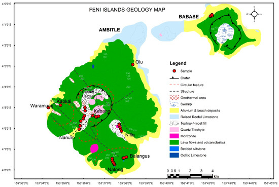
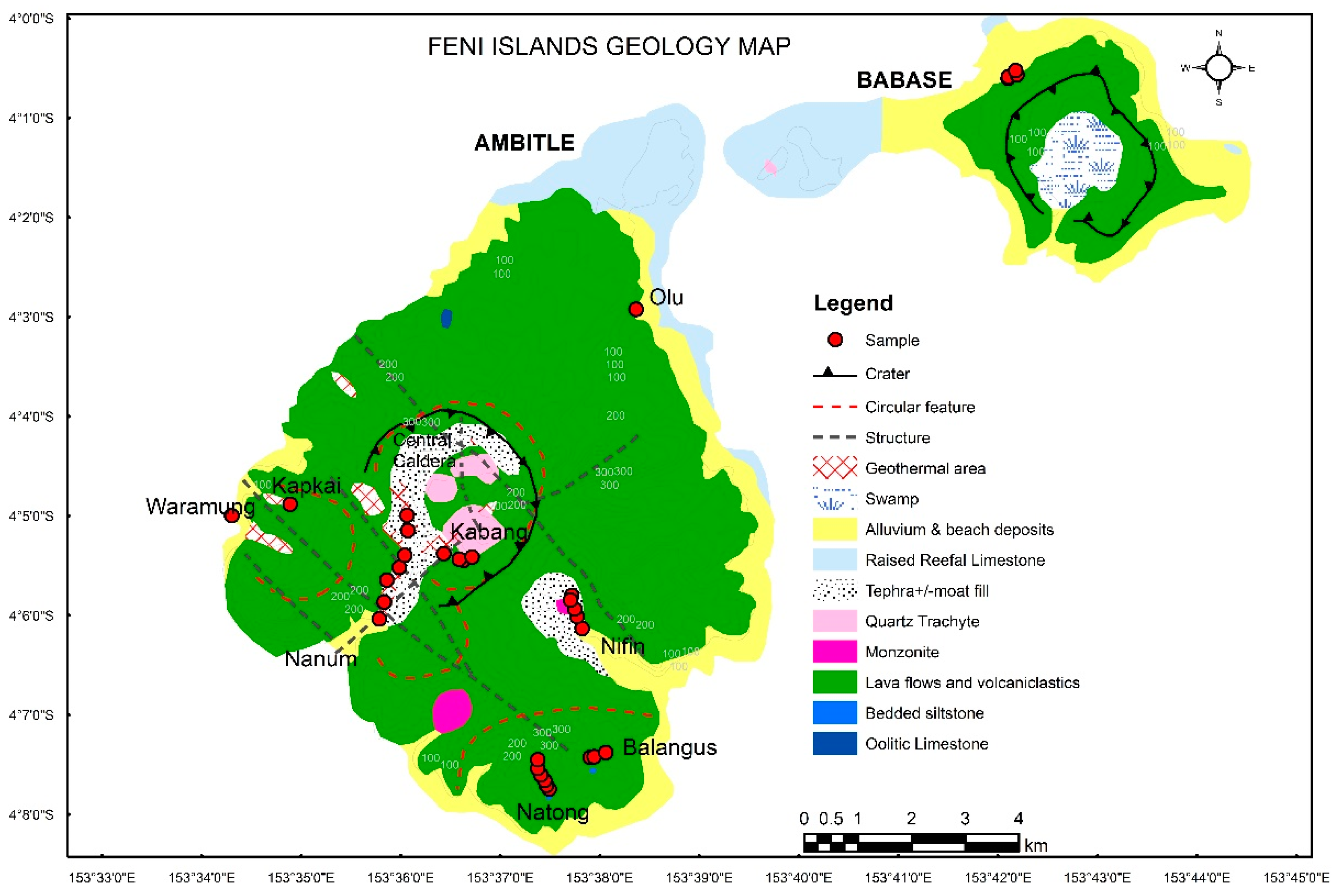
Figure 3.
Geology and sample location map of Feni Island Group. Geology map is based on our work and historical mapping by Wallace et al. [6] and others. Samples collected for further analysis shown in red.
The Niffin Graben is a major structural corridor that transects Ambitle from the southeast to the northwest (Figures 4 and 5). In the centre of the island is the Central Caldera at 3 km in diameter that was formed by the collapse of a high-level magma chamber [6]. The caldera floor is dominated by young, low-angle trachyte domes dated to K-Ar ages of 0.68 ± 0.1 Ma and 0.49 ± 0.1 Ma [58]. A recent crater, interpreted as an 800 m wide maar, is located on the eastern side of the domes and was possibly formed by a phreatomagmatic explosion which covered much of the Central Caldera with trachyte tuffaceous breccia, dated at 2300 years by carbon dating [49]. We also observed a 3 m thick unconsolidated, pyroclastic or tuffaceous deposit in the Niffin area which is proximal to and located east of the maar or crater (Figure 6B).
4. Babase and Ambitle Geology and Structure
In this section, we describe the geomorphology, structure, and geology of both Babase and Ambitle islands as observed during field excursions to Feni and from the digital elevation model (DEM).
Babase has an elevated central circular volcanic crater surrounded by lower elevations formed predominantly of basalt and coralline reef rocks (Figure 4). During our field trips to the island, it was impossible to visit the caldera on Babase due to cultural taboos. A bedded light-grey siltstone outcrop was mapped on Babase Island at Selselsik Creek. It appeared to be the basement rock upon which the coral reefal limestone was deposited. The siltstone unit was striking 140° and dipping 35° to the southwest (230°). It is characterized by a growth fault and alternating layers of orange-brown iron oxidation and greyish-white clay-rich beds. Argillic alteration is present as fine-grained pyrite and clay in parts proximal to the fault. The cobbles and boulders along the creeks and drainages on Babase are basaltic and trachybasaltic followed by intermediate trachyandesite and minor felsic trachydacite porphyry. Both Babase and Ambitle are distinctively girdled by fossiliferous fringing coral reefs, which are also evidence of on-going tectonic uplift.

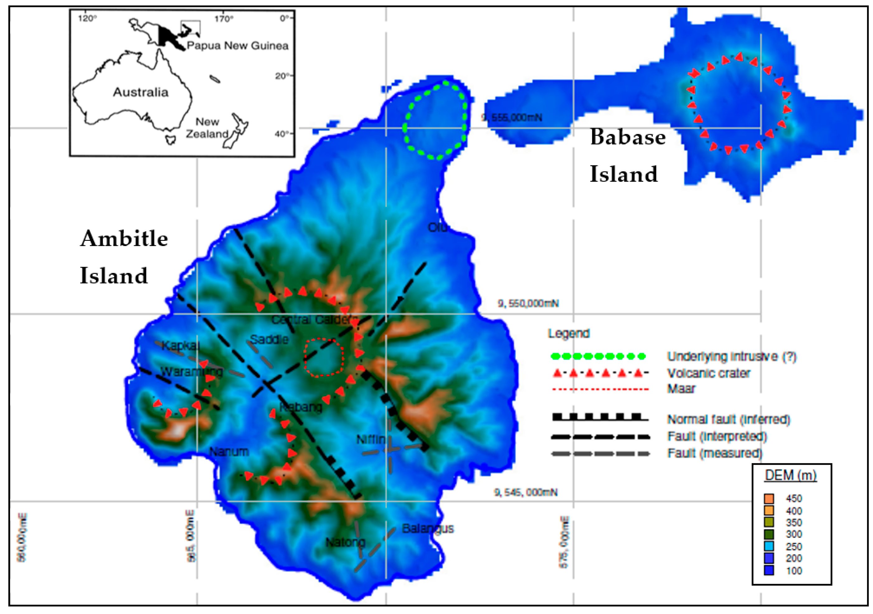
Figure 4.
SRTM digital elevation model (DEM) of Feni Islands. The main structures are indicated.
Ambitle is a composite volcanic island with potentially three main craters forming the central, western, and southern parts of the island. Ambitle is characterized by steep magmatic domes (Figure 6C), an eroded central caldera, and a field of hot springs and mud pools in the southern part of the island (i.e., Nanum), central region (i.e., Kabang, Caldera) and western side (i.e., Waramung, Kapkai). Lower-elevation coastlines are a mixture of the terminal zones of lavas and coralline limestone rock.
The main faults mapped on Ambitle Island are predominantly moderate-to-steeply dipping NW faults inferred as normal faults (Figure 3, Figure 4 and Figure 5). The geothermal activity and Cu-Au mineral prospects are aligned within the major NW structural corridor. The centre of the island has an eroded caldera, whilst in the east, the island is characterized by the Niffin Graben. This graben is described as a major structural corridor that transects Ambitle from the southeast to the northwest [6,63]. Mosusu [60] observed a positive magnetic anomaly coincident with the NW-trending Niffin Graben and interpreted it as a cooling intrusive body at depth responsible for the geothermal activity on Ambitle. Steep NW faults were also measured at Kapkai (on Ambitle) within a basaltic ridge actively precipitating native sulfur, and emitting geothermal steam. Other fault orientations measured on Ambitle are NS- and NE-trending structures at Natong and Niffin within the southeastern end of the NW structural corridor (Figure 4). The NS and NE structures (dipping W and NW, respectively) control pyrite mineralization and alteration hosted in trachyandesite outcrops at Natong and Balangus. A major NE structure that is mineralized with pyrite, kaolinite–smectite clay, and supergene-enriched hematite was mapped in Balangus and Natong (Figure 4).
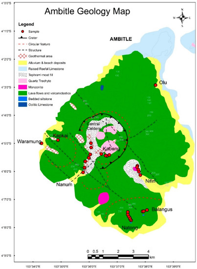
Figure 5.
Geology map of Ambitle. Red circles represent samples collected for this study.
The outcrops observed at Niffin, on eastern Ambitle, include a hornfelsed volcanogenic siltstone with doming fractures (Figure 6A), olivine–clinopyroxene-bearing pillow basalt, hornblende phonotephrite, welded tuff, and a bimodal pyroclastic deposit at Niffin (Figure 6B). The main outcrop at Natong is the hornblende–feldspar trachyandesite porphyry that is variably altered and weathered. A small outcrop of volcanogenic mudstone was also mapped in Natong. Balangus is also dominated by basaltic lava flows with minor trachyte and trachyandesite (Figure 5). The basaltic flows appear to predate the intermediate trachyandesite unit. Fault-controlled pyrite-clay mineralization along with propylitic chlorite–epidote–pyrite alteration were observed in Natong and Balangus. Nanum is predominantly basalt with minor occurrences of volcanic and hydrothermal breccia units towards the Central Caldera and Kabang areas. The tephra or ash cover occur throughout Niffin, Kabang, Central Caldera, and Nanum. We mapped and sampled pyroclastic flow, ash fall, and welded tuff at Niffin and Kabang. Scott [61] carbon-dated an ash fall deposit we sampled from Kabang at 2100 years.
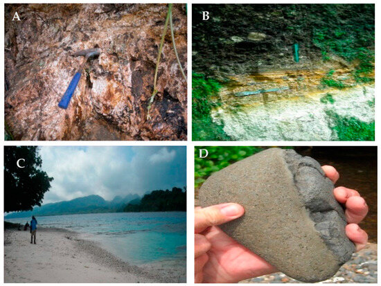
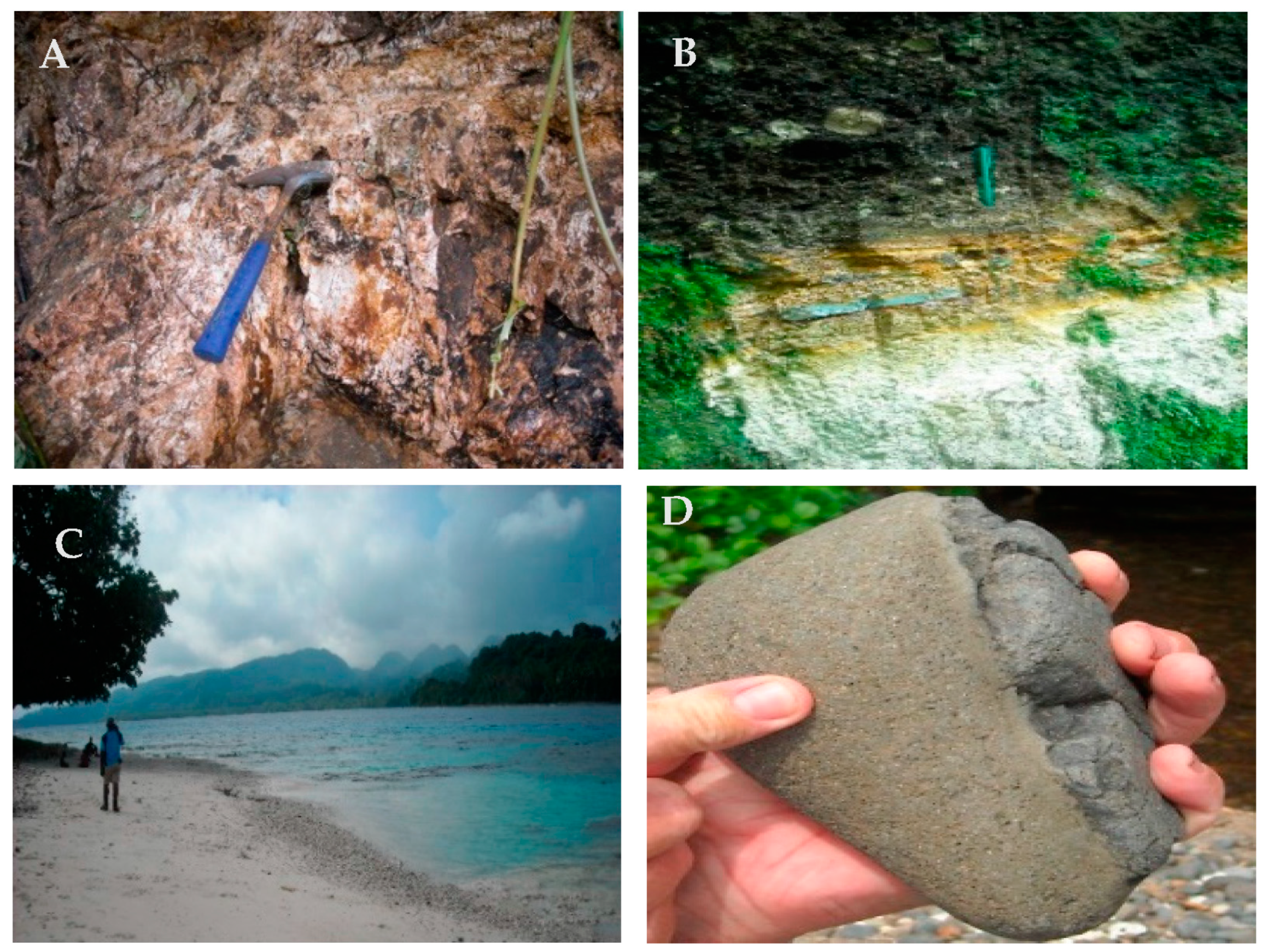
Figure 6.
Field images of Ambitle Island deposits and geomorphology. (A) Volcanogenic oxidized siltstone at Niffin. (B) Pyroclastic deposit at Niffin River. Weathered mafic matrix-supported pyroclastic lapilli-block tuff deposit unconformably overlying horizontal ash-clay bed (base surge) and quartz-pumice-rich felsic igimbritic layer. (C) Eastern side of Ambitle characterized by steep volcanic domes. Image taken from eastern point of Babase Island. (D) Vesicular feldspar–pyroxene phyric basaltic float containing a mafic or basaltic xenolith.
The main rock types sampled in this study include:
- Feldspathoid-bearing clinopyroxene > olivine basalt;
- Feldspathoid-bearing clinopyroxene > olivine trachybasalt;
- Clinopyroxene–amphibole phonotephrite;
- Hornblende trachyandesite;
- Quartz trachyte or biotite trachydacite.
These suites are aphanitic, trachytic, equigranular, and porphyritic in their textural variations, with the mafic and intermediate suites containing mafic mineral clusters and xenoliths. The stratigraphic relationships of the various rock types mapped in Ambitle are shown in Table 1. The results of the petrographic, whole-rock geochemistry and mineralogical analysis of these samples are presented and discussed in the sister paper currently in preparation by the same authors.

Table 1.
Simplified stratigraphy of Ambitle Island.
5. Discussion
The OJP is an important feature in the geotectonic and petrogenetic evolution of PNG and the TLTF. Building a general geological history in a numbered sequence or geochronological order is useful for understanding such a complex region. As such, this section summarizes the geological history of Feni and the TLTF using a generic approach and a specific tectono-magmatic and petrogenetic model.
The general geotectonic history of the TLTF is summarized as follows:
- The formation of the OJP in the Cretaceous (~122–120 Ma) from a mantle plume in the Pacific Oceanic Plate [36].
- The formation of the Eocene-to-Oligocene (~43–26 Ma) Melanesian Arc along the S-SW subduction of the Pacific Plate beneath the Australian Plate at the Manus–Kilinailau Trench. The island arcs formed include New Ireland, Manus, Bougainville, New Britain, and part of the Solomon Islands [36].
- The Oligocene–early Miocene (~26–20 Ma) disruption of the subduction zone as the OJP collided with the Manus–Kilinailau trench.
- Plate fragmentation leading to the formation of the Bismarck and Solomon microplates or sea plates.
- The New Britain Trench began around ~10–5 Ma as the Solomon sea plate started to subduct northwards beneath the Bismarck sea plate [36].
- The opening of the Manus Basin began around 3.5 Ma as the crust thinned in response to subduction at the New Britain Trench. Simberi’s age of 3.6 Ma [48] along with the isotopic signatures of TLTF lavas being similar to the Manus back-arc basin basalts suggests that the TLTF volcanics are closely linked to the extensional tectonics of the Manus Spreading Centre.
- Lihir being farther away implies that it is not influenced by the NBT; however, Feni shows geothermal isotopic signatures similar to that of the Rabaul Volcano, indicating that the NBT has some effect on Feni geothermal fluid chemistry.
A more specific tectono-magmatic and simplified petrogenetic model for the TLTF chain and Feni is presented below in chronological order:
- The Pacific MORB slab (with sediments) subducted and underwent dehydration and subsequent hydrous metasomatism of the overlying mantle in the Eocene. This led to the arc magmatism along the Kilinailau or Melanesian Trench forming the Jaulu Volcanics on New Ireland (and Baining Volcanics on New Britain).
- During the late Oligocene, the OJP arrived at the Kilinailau Trench. Subduction, and hence, magmatism completely ceased in the Miocene. Oolitic limestone was deposited on Feni in the late Oligocene. Lelet Limestone was deposited on New Ireland during the Miocene. These limestone units can serve as marker beds of the change in tectonism.
- Earlier structural grains were formed as ground preparation and plumbing for later magmas (due to earlier subduction and OJP collision).
- Following the onset of the NBT and the Manus Spreading Centre, deep lithospheric faults formed in the TLTF as a result of extensional tectonics [57].
- Adiabatic decompression melting of the subduction-modified upper mantle wedge formed the TLTF alkaline melts, which used the plumbing of deep extensional faults to form the TLTF volcanics and volcaniclastics from 3.6 Ma (Tabar age) to 2.1 ka (Feni age) [61].
- Feni magmatism was also possibly influenced by the NBT due to its proximity to the trench and the similarity in isotopic values to the Rabaul Volcano.
- Primitive and evolved magmas in the TLTF have similar isotopic signatures, signifying that they are closely related and have a common crystal fractionation trend [6].
- Olivine–feldspar mafic lavas initially formed at deeper parts of the upper mantle.
- Clinopyroxene-feldspathoid mafic lavas formed as the melt decompressed and travelled upwards.
- Hornblende-bearing intermediate lava formed at shallower depths, possibly when melting occurred in the hydrous, subduction-modified mantle wedge.
- Biotite–trachydacite porphyry formed from late crustal melts.
- Eruptive volcanism formed pyroclastic flows and ash falls.
- Present-day geothermal activity is associated with steep faults and craters within the Niffin Graben on Ambitle, possibly underlain by a cooling intrusive [60].
A geotectonic model of the Feni Island Group is presented in Figure 7. Feni is a horst structure within a horst-and-graben extended or rifted crustal–lithospheric setting. It is situated between subducting plates of opposite subduction polarity: the subducting Solomon Sea Plate and the Pacific Plate. The mantle beneath Feni has been modified and metasomatized by numerous geochemical source influences and processes, including a long history of southward subduction at the Kilinailau Trench prior to the Ontong Java Plateau impinging on the subduction zone. This introduced significant quantities of ocean sediment and volatiles. Furthermore, the Solomon Sea Plate is presently subducting at a high angle beneath Feni and could be torn in places (Figure 7). Similarly, the delaminated slab of the older Kilinailau Trench also provides a window for additional melts and fluids from depth. A hotter asthenosphere is introduced into the system as it convects beneath slab edges and or through tears in the subducting slabs. Slab melting could explain the high Sr/Y ratio or adakitic character of some Feni magmas, as noted by Brandl et al. [57]. The extensional setting allows for the creation of magma pathways deep into the lithosphere and incipient local melting linked to rifting. In conclusion, decompression or polybaric melting and crystal fractionation are petrogenetic processes responsible for the evolution of the mafic, intermediate, and felsic igneous rocks of Feni (Figure 7).
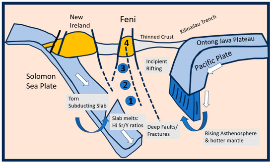
Figure 7.
Geotectonic schematic model for the Feni Island Group. Slab melting could explain the high Sr/Y shoshonitic character of some Feni magmas. The extensional setting allows for the creation of magma pathways deep into the lithosphere and incipient local melting linked to rifting. The numbers on the diagram are related to gradually shallower zones of melting that produced the following rock types in chronological order: (1) olivine–feldspar magmas; (2) clinopyroxene–feldspathoid mafic magmas; (3) amphibole-dominated magmatism; and (4) crustal melting that led to the crystallization of the biotite–quartz trachyte and trachydacite domes. South is situated to the left of the diagram.
6. Conclusions
Feni is a young volcanic island group in the TLTF chain located within the older Melanesian Arc in northeast Papua New Guinea. The Ontong Java Plateau collision with the Kilinailau Trench has played an important role in the geological history of PNG and the TLTF. Feni was most likely formed by extensional tectonics relating to the opening of the Manus Basin and the adiabatic decompression melting of a volatile-rich subduction-modified upper mantle relating to the older Melanesian Arc and possibly the present-day New Britain Trench. The main processes affecting the petrogenesis of the mafic to felsic volcanic rocks on Feni are crystal fractionation, assimilation or crustal contamination by ocean sediments, and the melting of a torn slab either from the older Kilinailau Trench or the present-day New Britain Trench [51,57,66]. In-depth analysis of the Feni geology through petrography, mineralogy, and geochemistry will be explored in detail in the next paper.
Author Contributions
Conceptualization, O.L.P.; methodology, O.L.P. and M.G.P.; software, O.L.P.; validation, O.L.P.; formal analysis, O.L.P. and M.G.P.; field investigation, O.L.P., M.G.P. and J.O.E.; writing—original draft preparation, O.L.P.; writing—review and editing, O.L.P. and M.G.P.; supervision, M.G.P. and J.O.E.; project administration, M.G.P. and J.O.E.; funding acquisition, M.G.P. and J.O.E. All authors have read and agreed to the published version of the manuscript.
Funding
This research was funded by the EU-funded Geomap Project (2006–2011) under the Mining Sector Support Program (MSSP) of the Mineral Resources Authority of Papua New Guinea.
Data Availability Statement
The data presented in this research paper may be obtained with permission from the Mineral Resources Authority by emailing oponyalou@mra.gov.pg.
Acknowledgments
This paper benefited from the constructive reviews of three anonymous reviewers. We thank the reviewers for their time and expertise. Fritz Bandelow, the Geomap Project, and the EU are acknowledged for funding this research through the Mineral Resources Authority, Papua New Guinea. This research was founded on a memorandum of understanding (MOU) between the University of Papua New Guinea and the University of Leicester (United Kingdom) in 2009. The good people of Babase and Ambitle Islands, including Paul Penua Mimfin and his family, are acknowledged for their hospitality and support during the field excursions. We also acknowledge the New Ireland Provincial Government authorities, namely, Kunibert Tibil, Bruce Harris, John Aini, and others for their assistance and cooperation during our trips to New Ireland in 2009 and 2011.
Conflicts of Interest
The authors declare no conflict of interest.
References
- Williamson, A.; Hancock, G. (Eds.) The Geology and Mineral Potential of Papua New Guinea/Compiled by Greg Corbett; Papua New Guinea Department of Mining: Port Moresby, Papua New Guinea, 2005.
- Van Wyck, N.; Williams, I.S. Age and provenance of basement metasediments from the Kubor and Bena Bena Blocks, central Highlands, Papua New Guinea: Constraints on the tectonic evolution of the northern Australian cratonic margin. Aust. J. Earth Sci. 2002, 49, 565–577. [Google Scholar] [CrossRef]
- Davies, H.L. The geology of New Guinea—The cordilleran margin of the Australian continent. Int. Union Geol. Sci. 2012, 35, 87–102. [Google Scholar] [CrossRef] [PubMed]
- Crowhurst, P.V.; Maas, R.; Hill, K.C.; Foster, D.A.; Fanning, C.M. Isotopic constraints on crustal architecture and Permo-Triassic tectonics in New Guinea: Possible links with eastern Australia. Aust. J. Earth Sci. 2004, 51, 107–124. [Google Scholar] [CrossRef]
- Ryburn, Talasea-Gasmata, New Britain—1: 250,000 Geological series Bureau of Mineral Resources, Geology and Geophysics of Australia, Explanatory Notes, sheet SB/56-5 and SB/56-9 1975; Australian Government Publishing Service for the Bureau of Mineral Resources, Geology, and Geophysics: Canberra, Australia, 1975. Available online: https://nla.gov.au/nla.obj-233559620/view (accessed on 27 September 2021).
- Wallace, D.A.; Johnson, R.W.; Chappell, B.W.; Arculus, R.J.; Perfit, M.R.; Crick, I.H. Cainozoic Volcanism of the Tabar, Lihir, Tanga and Feni Islands, Papua New Guinea: Geology, Whole-Rock Analyses and Rock-Forming Mineral Compositions; Australian Government Publishing Service for the Bureau of Mineral Resources: Canberra, Australia, 1983. Available online: https://nla.gov.au/nla.cat-vn1276195 (accessed on 27 September 2021).
- Petterson, M. Geo-Tectonics Geology and Geo-Resources of the Southwest Pacific: A Chapter within the Encyclopedia of Geology, 2nd ed.; Alderton, D., Elias, S.A., Eds.; Academic Press: Cambridge, MA, USA, 2021; pp. 724–741. [Google Scholar]
- DeMets, C.; Gordon, R.G.; Argus, D.F.; Stein, S. Effect of recent revisions to the geomagnetic reversal time scale on estimates of current plate motion. Geophys. Res. Lett. 1994, 21, 2191–2194. [Google Scholar] [CrossRef]
- Wallace, L.M.; Stevens, C.; Silver, E.; McCaffrey, R.; Loratung, W.; Hasiata, S.; Stanaway, R.; Curley, R.; Rosa, R.; Taugaloidi, J. GPS and seismological constraints on active tectonics and arc-continent collision in Papua New Guinea: Implications for mechanics of microplate rotations in a plate boundary zone. J. Geophys. Res. Solid Earth 2004, 109, B05404. [Google Scholar] [CrossRef]
- Davies, H.L. Tectonic setting of some mineral deposits of the New Guinea Region. In PNG Geology, Exploration and Mining Conference, Rabaul, June 1991; AusIMM: Carlton, Australia, 1991. [Google Scholar]
- Davies, H.L. New Guinea Geology. In The Encyclopedia of Islands; University of California Press: Berkeley, CA, USA, 2009; pp. 659–664. [Google Scholar]
- Sheppard, S.; Cranfield, L. Geological Framework and Mineralization of Papua New Guinea—An Update; Mineral Resources Authority: Port Moresby, Papua New Guinea, 2012.
- Bulois, C.; Pubellier, M.; Chamot-Rooke, N.; Delescluse, M. Successive Rifting Events in Marginal Basins: The Example of the Coral Sea Region (Papua New Guinea). Tectonics 2018, 37, 3–29. [Google Scholar] [CrossRef]
- Tcherepanov, E.N.; Droxler, A.W.; Lapointe, P.; Dickens, G.; Bentley, S.J.; Beaufort, L.; Peterson, L.; Daniell, J.; Opdyke, B.N. Neogene evolution of the mixed carbonate-siliciclastic system in the Gulf of Papua, Papua New Guinea. J. Geophys. Res. Earth Surf. 2008, 113, F01S21. [Google Scholar] [CrossRef]
- Willmott, W. Daru-Maer, Papua and Queensland—1: 250,000 Geological Series Explanatory Note; Bureau of Mineral Resources: Canberra, Australia, 1972.
- Dow, D.B.; Smit, J.A.J.; Bain, J.H.; Ryburn, J. Geology of the South Sepik Region, New Guinea; Australian Government Publishing Service: Canberra, Australia, 1972.
- Pigram, C.J.; Davies, H.L. Terranes and the accretion history of the New Guinea orogen. BMR J. Aust. Geol. Geophys. 1987, 10, 193–211. [Google Scholar]
- Page, R.W. Geochronology of igneous and metamorphic rocks in the New Guinea Highland. Bull. Aust. Bu Miner. Resou 1976, 162, 10–15. [Google Scholar]
- Tingey, R.; Grainger, D. Markham–Papua New Guinea, 1: 250,000 Geological Series with Explanatory Notes; International Index Sheet Sb/55-10; Geological Survey of Papua New Guinea: Port Moresby, Papua New Guinea, 1976.
- Bodorkos, S.; Sheppard, S.; Saroa, D.; Tsiperau, C.U.; Sircombe, K. New SHRIMP U-Pb zircon ages from the Wau-Bulolo region, Papua New Guinea. Geosci. Aust. Rec. 2013, 25. [Google Scholar] [CrossRef]
- Davies, H.; Perembo, B.; Winn, D.; Kengemar, P. Terranes of the New Guinea Orogen. In Proceedings of the PNG Geology, Exploration and Mining Conference 1997, Madang, Papua New Guinea, 10–12 October 1997; pp. 61–66. [Google Scholar]
- Lus, W.Y.; McDougall, I.; Davies, H.L. Age of the metamorphic sole of the Papuan Ultramafic Belt ophiolite, Papua New Guinea. Tectonophysics 2004, 392, 85–101. [Google Scholar] [CrossRef]
- Petterson, M.G.; Babbs, T.; Neal, C.R.; Mahoney, J.J.; Saunders, A.D.; Duncan, R.A.; Tolia, D.; Magu, R.; Qopoto, C.; Mahoa, H.; et al. Geological-tectonic framework of Solomon Islands, SW Pacific: Crustal accretion and growth within an intra-oceanic setting. Tectonophysics 1999, 301, 35–60. [Google Scholar] [CrossRef]
- Johnson, W. Geotectonics and volcanism in Papua New Guinea: A review of the late Cainozoic. BMR J. Aust. Geol. Geophys. 1979, 4, 181–207. [Google Scholar]
- Audley-Charles, M.G. Tectonics of the New Guinea Area. Annu. Rev. Earth Planet. Sci. 1991, 19, 17–41. [Google Scholar] [CrossRef]
- Yan, C.; Kroenke, L. A plate tectonic reconstruction of the southwest Pacific, 0–100 Ma. In Proceedings of the Ocean Drilling Program, Scientific Results; 1993; Volume 130. Available online: http://www-odp.tamu.edu/publications/130_SR/VOLUME/CHAPTERS/sr130_43.pdf (accessed on 27 September 2021).
- Horz, H.K.; Worthington, J.T.; Winn, K.; Stoffers, P. Late Quaternary tephra in the New Ireland Basin, Papua New Guinea. J. Volcanol. Geotherm. Res. 2004, 132, 73–95. [Google Scholar] [CrossRef]
- Crook, K.; Belbin, L. The southwest Pacific area during the last 90 million year. J. Geol. Soc. Aust. 1978, 25, 23–40. [Google Scholar] [CrossRef]
- Gaina, C.; Müller, R.D.; Royer, J.Y.; Symonds, P. Evolution of the Louisiade triple Junction. J. Geophys. Res. 1999, 104, 12927–12939. [Google Scholar] [CrossRef]
- Hall, R. Cenozoic geological and plate tectonic evolution of SE Asia and the SW Pacific: Computer-based reconstructions, model, and animation. J. Southeast Asian Sci. 2002, 20, 353–434. [Google Scholar] [CrossRef]
- Hall, R.; Spakman, W. Subducted slabs beneath the eastern Indonesia–Tonga region: Insights from tomography. Earth Planet. Sci. Lett. 2002, 201, 321–336. [Google Scholar] [CrossRef]
- Mann, P.; Taira, A. Global tectonic significance of the Solomon Islands and Ontong Java Plateau convergent zone. Tectonophysics 2004, 389, 137–190. [Google Scholar] [CrossRef]
- Exon, N.F.; Marlow, M.S. The New Ireland Basin: A frontier basin in Papua New Guinea. In Proceedings of the First Petroleum Convention, Port Moresby, Papua New Guinea, 12–14 February 1990. [Google Scholar]
- Furumoto, A.; Webb, J.; Odegard, M.E.; Hussong, D. Seismic studies on the Ontong Java Plateau, 1970. Tectonophysics 1976, 34, 71–90. [Google Scholar] [CrossRef]
- Fitton, J.G.; Mahoney John, J.; Wallace Paul, J.; Saunders Andrew, D. Origin and evolution of the Ontong Java Plateau: Introduction. Geol. Soc. Lond. Spec. Publ. 2004, 229, 1–8. [Google Scholar] [CrossRef]
- Holm, R.J.; Spandler, C.; Richards, S.W. Melanesian arc far-field response to collision of the Ontong Java Plateau: Geochronology and petrogenesis of the Simuku Igneous Complex, New Britain, Papua New Guinea. Tectonophysics 2013, 603, 189–212. [Google Scholar] [CrossRef]
- Coleman, P.; Kroenke, L. Subduction without volcanism in the Solomon Islands arc. Geo-Mar. Lett. 1981, 1, 129–134. [Google Scholar] [CrossRef]
- Martinez, F.; Taylor, B. Backarc spreading, rifting, and microplate rotation between transform faults in the Manus Basin. Mar. Geophys. Res. 1996, 18, 203–224. [Google Scholar] [CrossRef]
- Tregoning, P.; Lambeck, K.; Stolz, A.; Morgan, P.; McClusky, S.; van der Beek, P.; McQueen, H.; Jackson, J.; Little, P.; Laing, A.; et al. Estimation of current plate motions in Papua New Guinea from Global Positioning System observation. J. Geophys. Res. 1998, 103, 12181–12203. [Google Scholar] [CrossRef]
- Woodhead, J.D.; Eggins, S.M.; Johnson, W. Magma Genesis in the New Britain Island Arc: Further Insights into Melting and Mass Transfer Processes. J. Petrol. 1998, 39, 1641–1668. [Google Scholar] [CrossRef]
- Lindley, I.D. New Britain Trench, Papua New Guinea: An extensional element in a regional sinistral strike-slip system. New Concepts Glob. Tecton. Newsl. 2006, 41, 16–28. [Google Scholar]
- Lindley, I.D. Early Cainozoic stratigraphy and structure of the Gazelle Peninsula, East New Britain: An example of extensional tectonics in the New Britain arc-trench complex. Aust. J. Earth Sci. 1988, 35, 231–244. [Google Scholar] [CrossRef]
- Rogerson, R.J.; Hilyard, D.; Silver, E. Excursion Guide to the Papua New Guinea Collision Zone; Papua New Guinea Geological Survey Report 88/17; PNG Geological Survey: Port Moresby, Papua New Guinea, 1988.
- McInnes, B.I.A.; Cameron, E.M. Carbonated, alkaline hybridizing melts from a sub-arc environment: Mantle wedge samples from the Tabar-Lihir-Tanga-Feni arc, Papua New Guinea. Earth Planet. Sci. Lett. 1994, 122, 125–141. [Google Scholar] [CrossRef]
- O’Kane, T.P. 3-D Structure and Tectonic Evolution of the Papua New Guinea and Solomons Island Region and Its Relationship to Cu-Au Mineralisation. Unpublished B.Sc. Honours Thesis, Research School of Earth Sciences, Australian National University, Canberra, Australia, 2008. [Google Scholar]
- Holwell, D.A.; Fiorentini, M.; McDonald, I.; Lu, Y.; Giuliani, A.; Smith, D.J.; Keith, M.; Locmelis, M. A metasomatized lithospheric mantle control on the metallogenic signature of post-subduction magmatism. Nat. Commun. 2019, 10, 3511. [Google Scholar] [CrossRef] [PubMed]
- Taylor, B. Bismarck Sea: Evolution of a back-arc basin. Geology 1979, 7, 171–174. [Google Scholar] [CrossRef]
- Rytuba, J.J.; McKee, E.H.; Cox, D.P. Geochronology and geochemistry of the Ladolam gold deposit, Lihir Island, and gold deposits and volcanoes of Tabar and Tatau, Papua New Guinea, U.S. Geol. Surv. Bull. 1993, 2039, 119–126. [Google Scholar]
- Licence, P.S.; Terrill, J.E.G.; Fergusson, L.J. Epithermal gold mineralisation, Ambitle Island, Papua New Guinea. In Pacific Rim Congress 87; The Australasian Institute of Mining and Metallurgy: Gold Coast, Australia, 1987; pp. 273–278. [Google Scholar]
- Patterson, D.B.; Farley, K.A.; McInnes, B.I.A. Helium isotopic composition of the Tabar-Lihir-Tanga-Feni island arc, Papua New Guinea. Geochim. Et Cosmochim. Acta 1997, 61, 2485–2496. [Google Scholar] [CrossRef]
- Kamenov, G.D.; Perfit, M.; Mueller, P.A.; Jonasson, I. Controls on magmatism in an island arc environment: Study of lavas and sub-arc xenoliths from the Tabar-Lihir-Tanga-Feni island chain, Papua New Guinea. Contrib. Mineral. Petrol. 2008, 155, 635–656. [Google Scholar] [CrossRef]
- Kennedy, A.K.; Hart, S.; Frey, F.A. Composition and isotopic constraints on the petrogenesis of alkaline arc lavas: Lihir Island, Papua New Guinea. J. Geophys. Res. 1990, 95, 6929–6942. [Google Scholar] [CrossRef]
- Farley, K.A.; Patterson, D.; McInnes, B. He-isotopic investigation of geothermal gases from the Tabar-Lihir-Tanga-Feni arc and Rabaul, Papua New Guinea. AIP Conf. Proc. 1995, 341, 81–90. [Google Scholar] [CrossRef]
- Hohnen, P.D. Geology of New Ireland, Papua New Guinea; Bulletin 194, PNG 12, Depart. National. Dev., Bureau of Mine. Resou Geol. and Geophysic.; Australian Government Publishing Service: Canberra, Australia, 1978; 46p.
- Stewart, W.D.P.; Sandy, M.J. Geology of New Ireland and Djaul Islands, Northeastern Papua New Guinea. In Geology and Offshore Resources of Pacific Island Arcs—New Ireland and Manus Region, Papua New Guinea; Marlow, M.S., Dadisman, S.V., Exon, N.F., Eds.; Vol. Earth Science Series 9; Circum-Pacific Council for Energy and Mineral Resources: Houstin, TX, USA, 1988. [Google Scholar]
- Lindley, I.D. Plate flexure and volcanism: Late Cenozoic tectonics of the Tabar–Lihir–Tanga–Feni alkalic province, New Ireland Basin, Papua New Guinea. Tectonophysics 2016, 677–678, 312–323. [Google Scholar] [CrossRef]
- Brandl, P.; Hannington, M.; Geersen, J.; Petersen, S.; Gennerich, H. The submarine tectono-magmatic framework of Cu-Au endowment in the Tabar-to-Feni island chain, PNG. Ore Geol. Rev. 2020, 121, 103491. [Google Scholar] [CrossRef]
- Johnson, W.; Wallace, D.A.; Ellis, D.J. Feldspathoid-bearing potassic rocks and associated types from volcanic islands off the coast of New Ireland, Papua New Guinea: A preliminary account of geology and petrology. In Volcanism in Australasia; Elsevier: Amsterdam, The Netherlands, 1976; pp. 297–316. [Google Scholar]
- Heming, R.F. Undersaturated lavas from Ambittle Island, Papua New Guinea. Lithos 1979, 12, 173–186. [Google Scholar] [CrossRef]
- Mosusu, N. Structural Controls of the Feni Geothermal System: Insights from Magnetic and Radiometric Dataset Geological Survey of Papua New Guinea; Department of Mining: Port Moresby, Papua New Guinea, 2004. [Google Scholar]
- Scott, E. The Petrogenesis of Feni Islands Volcanoes, Papua New Guinea: Post Subduction Volcanic Rocks? University of Leicester: Leicester, UK, 2011. [Google Scholar]
- Ponyalou, L.K.O. The Volcanic Rocks & Sinters of Ambitle Island, Feni Island, New Ireland Province, Papua New Guinea. Honours Thesis, University of Papua New Guinea, Port Moresby, Papua New Guinea, 2013. [Google Scholar]
- Lindley, I.D. Late Quaternary geology of Ambitle Volcano, Feni Island Group, Papua New Guinea. Aust. J. Earth Sci. 2015, 62, 529–545. [Google Scholar] [CrossRef]
- Kumul, C. Preliminary Geothermal Investigation of Feni Island, New Ireland Province, Papua New Guinea; Technical Note 2017/01; Mineral Resources Authority: Port Moresby, Papua New Guinea, 2017.
- Lindley, I.D. Matangkaka manganese deposit, Ambitle Island, Feni Island Group, Papua New Guinea: A Quaternary epithermal stratabound manganese oxide deposit. Aust. J. Earth Sci. 2022, 69, 26–46. [Google Scholar] [CrossRef]
- Guo, F.; Wu, Y.; Zhang, B.; Zhang, X.; Zhao, L.; Liao, J. Magmatic responses to Cretaceous subduction and tearing of the paleo-Pacific Plate in SE China: An overview. Earth-Sci. Rev. 2021, 212, 103448. [Google Scholar] [CrossRef]


Disclaimer/Publisher’s Note: The statements, opinions and data contained in all publications are solely those of the individual author(s) and contributor(s) and not of MDPI and/or the editor(s). MDPI and/or the editor(s) disclaim responsibility for any injury to people or property resulting from any ideas, methods, instructions or products referred to in the content. |
© 2023 by the authors. Licensee MDPI, Basel, Switzerland. This article is an open access article distributed under the terms and conditions of the Creative Commons Attribution (CC BY) license (https://creativecommons.org/licenses/by/4.0/).