Article

Reconnaissance of the Effects of the MW5.7 (ML6.4) Jajarkot Nepal Earthquake of 3 November 2023, Post-Earthquake Responses, and Associated Lessons to Be Learned

1
Geo-Infra Research Institute, 44600 Lalitpur, Nepal
2
BGC Engineering Inc., Fredericton, NB E3C OA9, Canada
3
Department of Environmental Design, Faculty of Collaborative Regional Innovation, Graduate School of Science and Engineering, Ehime University, Matsuyama 790-8577, Japan
4
A. Alfred Taubman College of Architecture and Urban Planning, University of Michigan, Ann Arbor, MI 48109-2069, USA
*
Author to whom correspondence should be addressed.
Geosciences 2024, 14(1), 20; https://doi.org/10.3390/geosciences14010020
Submission received: 11 December 2023 / Revised: 4 January 2024 / Accepted: 5 January 2024 / Published: 7 January 2024
(This article belongs to the Section Natural Hazards)

Abstract

:
On 3 November 2023, a moment magnitude (MW) 5.7 (Local Magnitude, ML6.4) earthquake struck the western region of Nepal, one of the most powerful seismic events since 1505 in the region. Even though the earthquake was of moderate magnitude, it caused significant damage to several masonry buildings and caused slope failures in some regions. The field reconnaissance carried out on 6–9 November by the study team, following the earthquake, conducted the first-hand preliminary damage assessment in the three most affected districts—Jajarkot; West Rukum; and Salyan. This study covers the observed typical structural failures and geotechnical case studies from the field study. To have a robust background understanding, this paper examines the seismotectonic setting and regional seismic activity in the region. The observations of earthquake damage suggest that most of the affected buildings were made of stone or brick masonry without seismic consideration, while most of the reinforced concrete (RC) buildings remained intact. Case histories of damaged buildings, the patterns, and the failure mechanisms are discussed briefly in this paper. Significant damage to Khalanga Durbar, a historical monument in Jajarkot, was also observed. Medium- to large-scale landslides and rockfalls were recorded along the highway. The motorable bridge in the Bheri River suffered from broken bolts, rotational movement at the expansion joint, and damage to the stoppers. The damage observations suggest that, despite the existence of building codes, their non-implementation could have contributed to the heavy impact in the region. This study highlights that the local population faces a potential threat of subsequent disasters arising from earthquakes and earthquake-induced landslides. This underscores the necessity for proactive measures in preparedness for future disasters.

1. Introduction

On 3 November 2023, a magnitude 5.7 earthquake struck Jajarkot District, Karnali Province, Nepal, at 23:47 local time (Figure 1). The earthquake’s epicenter was located in Ramidanda village, Barekot Rural Municipality, at a latitude of 28°50′24′′ N and a longitude of 82°11′24′′ E, with a focal depth of 10 km. The Mw5.7 subduction earthquake occurred along the Main Himalayan Thrust (MHT) and triggered numerous major aftershocks. The maximum shaking intensity is estimated at around VIII on the MSK scale [1]. A series of aftershocks followed, two of which, magnitudes of 4.0 and 5.3, occurred within three days of the mainshock and within 10 km from the epicenter. The earthquake was widely felt in western Nepal and northern India, marking the deadliest seismic event in the country since 2015. Jajarkot was the most affected district in Nepal, followed by West Rukum and Salyan. The occurrence of earthquakes in the region is primarily attributed to the tectonic settings of the Himalayas, including the Himalayan Frontal Thrust (HFT), Main Boundary Thrust (MBT), and Main Central Thrust (MCT), along with several local faults and geologically demarcated lineaments [2,3,4]. As a result of the earthquake, structures across most of the affected area sustained severe damage. Significant damage was incurred to buildings, roads, bridges, ancient durbars, and temples. Widespread landslides, rock falls, and mudslides, particularly along the national highways, further intensified the impact. Most structures lacked seismic design and were constructed with stones featuring smooth surfaces and bound with mud mortar, rendering them susceptible to earthquake damage. The multi-story reinforced concrete (RC) non-engineered buildings in the region suffered either irreparable structural damage or complete collapse.
The collapse and impairment of buildings (26,557 households fully damaged and 35,455 households partially damaged) primarily contributed to the loss of life and associated economic damages. The reported total loss of life from the disaster is 154, with 101 fatalities in the Jajarkot district alone and the remainder in the West Rukum district. The number of injured individuals was reported at 366 in early reports (as of 20 November) [5]. The overall estimated economic loss is around US $500 million as preliminary documented by Ministry of Home Affairs. This event has prompted heightened discussions regarding the seismic resilience of buildings in Nepal when exposed to moderate to strong ground shaking.
The substantial damage and casualties resulting from the earthquake, despite its relatively low magnitude, can be predominantly attributed to substandard construction practices prevalent in the region. The widespread use of locally available materials such as stone, mud, stacked logs, and rocks significantly amplified the scale of devastation, especially when not considered without seismic consideration. Moreover, the lack of stringent enforcement of building codes in the area, stemming from a combination of low awareness and economic challenges, notably contributed to the extent of the damage. This event has accelerated discussions concerning the seismic performance of buildings in Nepal when subjected to moderate to strong ground shaking. Additionally, the temporal occurrence of the earthquake intensified its impact, taking place during the night when a considerable portion of the population was asleep. The challenging terrain, reduced visibility, and compromised or collapsed infrastructure impeded the initial rescue and relief efforts.
The Himalayan region exhibits high seismic activity attributed to the ongoing collision between the Indian and Eurasian tectonic plates. Recognized as seismically hazardous, the entire Himalayan arc has a history of significant earthquakes. Nepal, situated in this active seismic zone, is renowned for frequently experiencing powerful earthquakes [6,7,8]. Despite Nepal’s long history of seismic events, the 1934 earthquake marks the first documented earthquake from a modern seismological perspective [9]. Notably, the devastating MW7.8 earthquake in 2015 in Gorkha, Nepal, resulted in widespread destruction and loss of life, drawing substantial attention from researchers in the field of disaster studies and seismic risk assessment for the region.
Studies from past earthquakes have underscored the lack of preparedness in construction practices and design methodologies, particularly in structural and geotechnical aspects [10,11]. Several researchers [12,13,14,15,16] have reported the geotechnical and structural aspects of the earthquake, including building performance during earthquakes in Nepal. However, these studies were focused on the earthquakes that occurred in eastern Nepal. Though western Nepal has experienced a significant number of small earthquakes in the last few years (Figure 2), this earthquake was one of the most powerful seismic events since 1505 (MS~8.2) in western Nepal (Figure 3). The absence of significant seismic activity in western Nepal for the past 518 years suggests that a considerable amount of tectonic stress and energy may have accumulated in the region. Several studies have warned that an enormous build-up of strain in the region is likely to result in at least one earthquake of MW8.5 or more in the western part of Nepal [17,18]. In this regard, this seismic event has provided an opportunity to evaluate the performance of structures during the earthquake in western Nepal.
This post-earthquake reconnaissance study plays a crucial role in advancing the understanding of earthquakes, improving infrastructure resilience, and enhancing the overall preparedness of communities to mitigate the impact of future seismic events [11,19,20]. Moreover, post-earthquake reconnaissance provides an opportunity to understand the earthquake effects, improve seismic hazard assessment, validate the seismic building code, update the existing emergency management and preparedness, improve future construction, and educate the public by explaining the causes of damage [21].
This study leverages the authors’ experiences from previous earthquakes, including the 2015 Gorkha, Nepal earthquake [7,11,12,13,22,23,24,25]. Its objective is to investigate seismic vulnerabilities in diverse buildings and infrastructure in western regions, emphasizing the challenges of reconstruction. The analysis will discern the impact on structures, identify contributing factors, and offer valuable insights for future research. This paper, based on a field reconnaissance conducted three days post-earthquake on 6–9 November 2023, by the team of the Nepal Geotechnical Society (NGS), explores the seismo-tectonic aspects, structural and geotechnical damage features, and challenges for reconstruction. It focuses on damage assessment of residential and public buildings, telecommunications, and lifelines, and additionally addresses building damage typology and failure patterns. This study adopts a holistic approach, including brief interviews with local people, local authorities, and government engineers in the region to understand the rescue and reconstruction challenges. This paper concludes with recommendations for post disaster reconstruction and improving seismic resilience in the region.
The route and location of investigation sites are shown in Figure 4, along with the epicenters of the mainshock.

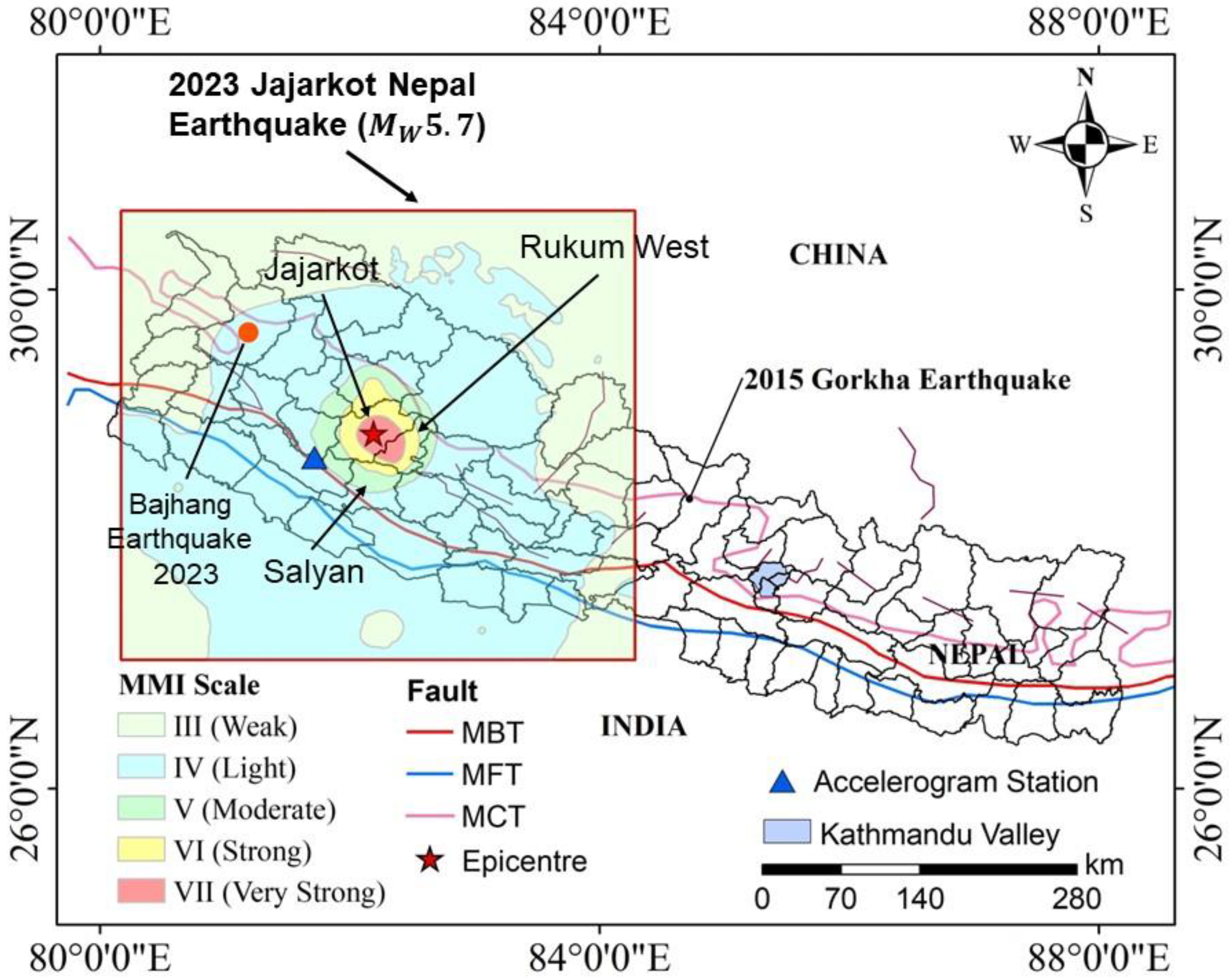
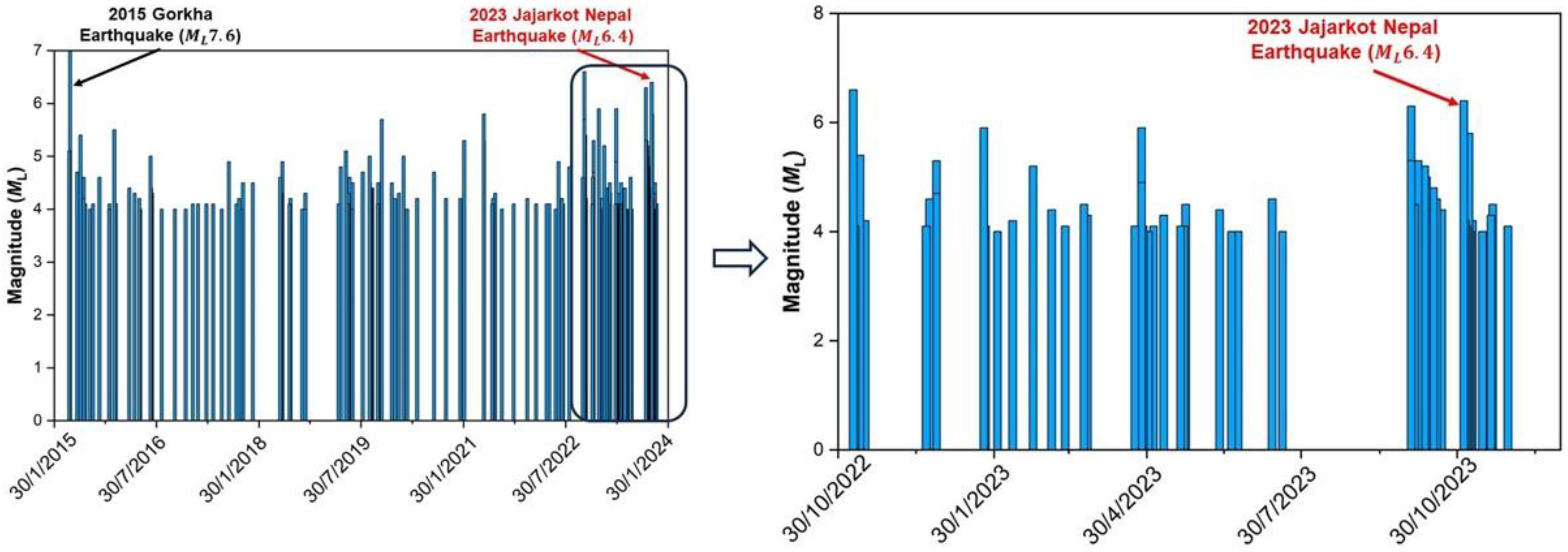
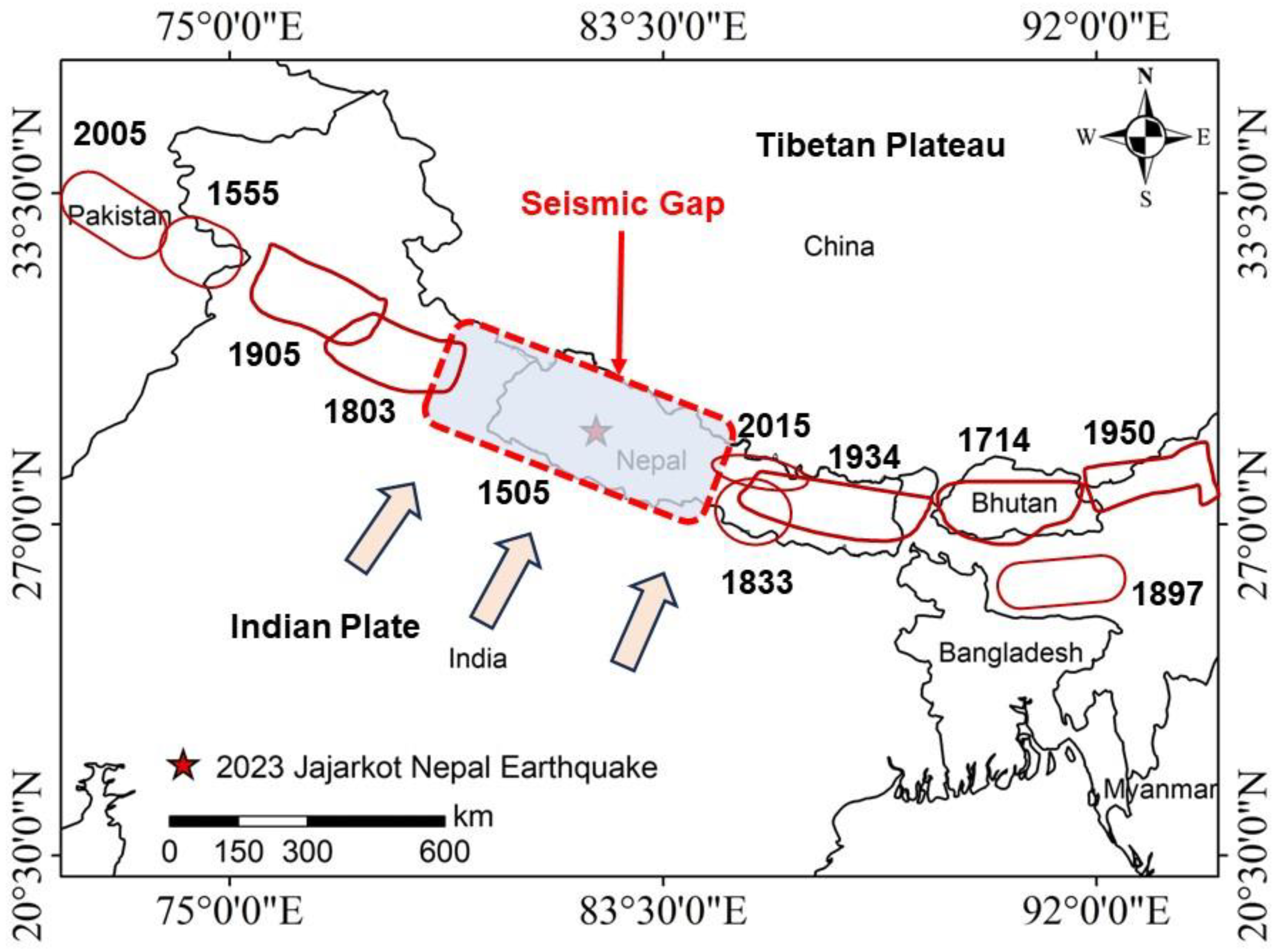
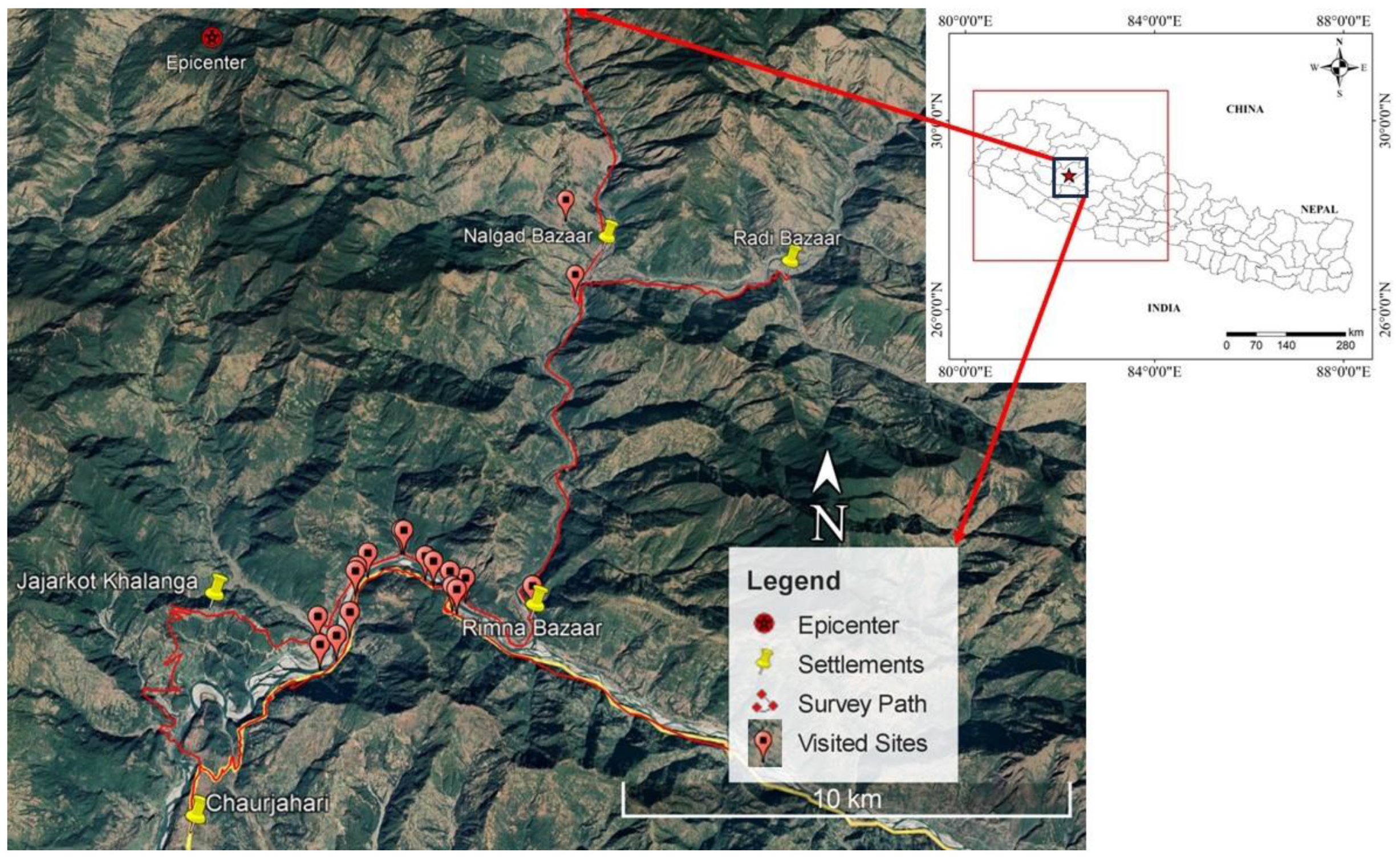
2. Ground Motion and Seismo-Tectonic Aspects

The Nepal Himalaya frequently experiences earthquakes of varying magnitudes from east to west. Nepal is situated along the active Main Himalayan Thrust (MHT) arc, where the subducting Indian plate and Eurasian plate are converging at a rate of approximately 4–5 cm/year [25,26]. This interaction controls the region’s seismotectonic activity, rendering the Nepal Himalaya at a higher seismic risk than any other area in the Hindu-Kush-Himalaya region [10]. The Indian Plate is thrust beneath the continental crust of the Eurasian Plate, forming thrust faults along the collision zone. The Main Frontal Thrust predominantly accommodates this motion. Based on a study published in 2014 of the Main Frontal Thrust, on average, a magnitude 8 or larger earthquake occurs every 750 ± 140 and 870  ±  350 years in the east Nepal region. This has been observed by several past earthquakes in Nepal, such as those in 1255, 1408, 1681, 1803, 1833, 1866, 1934, 1988, 1991, and 2015, highlighting the intense seismic risk in the region.
In 1505, western Nepal experienced an MW8.2 earthquake west of the 2015 rupture zone. The accumulated strain since then, without release, suggests a likelihood of the occurrence of stronger earthquakes in the area in the future [25]. The seismic gap in the region can be seen in Figure 3. The seismic activity in the western Nepal Himalayan region showed variations between high and low seismic phases from 1963 to 2006 [3]. These events are most likely caused by the Main Boundary Thrust (MBT) and traverse features present in the region. The existence of a weak Main Himalayan Thrust beneath Tibet with the initiation of the Main Central Thrust can be explained by the South Tibetan Detachment and corresponding stress field in western Nepal [3]. Recently, a major earthquake struck western Nepal in Bajhang district. The Bajhang earthquake (Figure 1) occurred on 3 October 2023 and had a magnitude of MW5.3. It was followed by stronger aftershocks that caused damage to both public and private structures. The earthquake was felt not only in neighboring districts but also in Kathmandu and Delhi, India.
The three-component recorded accelerogram that was taken at Bhimchula station during the MW5.7 Jajarkot, Nepal, Earthquake 2023 mainshock is shown in Figure 5. The closest accelerogram station to the epicenter is Bhimchula, and Nepal has limited seismological and accelerogram stations scattered throughout the nation. It is clear from looking at the time-history data that during the mainshock, the peak ground acceleration (PGA) for the ground motions that were recorded reached up to 70 cm/s2. The PGA recorded is lower than the projected PGA (295–340 cm/s2) obtained using probabilistic seismic hazard analysis (PSHA) with a 10% likelihood of exceedance over a 50-years’ time period by NBC [27].

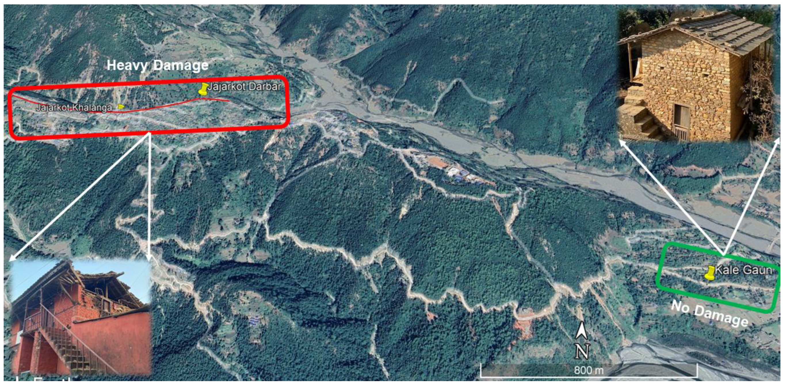
3. Building Damage Assessment

3.1. Building Typology and Design Codes in Nepal

Nepal encompasses a diverse array of buildings, each defined by distinct construction types, typologies, and material selections. Common construction technologies include adobe, timber, stone in mud mortar, brick in mud mortar, stone in cement mortar, brick in cement mortar, non-engineered reinforced concrete (RC), and engineered RC. Wooden constructions, characterized by walls comprising wooden planks, are also frequently encountered in proximate forested areas, while stone in mud mortar assemblies dominate hilly and mountainous terrains.
In its challenging terrain, public infrastructures often deploy stone masonry with cement mortar, while houses in urban areas accessible by road use brick with cement mortar. After the 1988 Udayapur earthquake and the 2015 Gorkha earthquake, RC moment-resisting frame structures have emerged as the predominant choice for public and commercial construction. However, according to the National Population and Housing Census 2021, mud-bonded brick/stone masonry structures are still dominant in all regions of Nepal, constituting 30.7% of all structures, while wooden/bamboo buildings amounted to 14.9% [29]. Adobe, brick, and stone masonry structures utilizing mud mortar are particularly vulnerable to seismic events due to their substantial mass, brittle, low-strength materials, and insufficient detailing and maintenance.
The building typologies recorded in 2021 CBS data (Table 1) also illustrate that more than 92% of buildings in the region are Mud-bonded brick or stone-masonry buildings.
The earthquake in 1988 AD (2045 BS), claiming over 700 lives in Nepal, necessitated the development of the Nepal Building Code [30]. Initiated in 1993 with financial support from UNDP/UNCHS (Habitat) and involving international consultants, the code was completed in 1994. Officially sanctioned by the government in 2003, the National Building Code (NBC) became mandatory for urban municipalities. However, no equivalent regulations were imposed on towns and villages governed by rural municipalities. Despite legal enforcement in 2005, monitoring the code’s implementation faced significant challenges due to resource constraints. The National Building Code (NBC: 105:2020) for Seismic Design of Buildings, along with guidelines for Earthquake Resistant Construction of Low Strength Masonry (NBC 203: 2015) and Earthen Building (NBC 204: 2015), plays a crucial role in seismic conditions but has not been effectively implemented even after two decades [31].
While having robust building codes is fundamental, their efficacy depends on effective enforcement. Many local governments, particularly in rural municipalities, have struggled to fully implement building codes due to economic constraints and insufficient awareness. To enhance safety, local governments should introduce and enforce stringent measures, compelling residents to construct earthquake-resistant houses.

3.2. Residential Buildings

The damage survey focused on assessing the performance of residential buildings made of masonry and reinforced concrete in Jajarkot and West Rukum districts, which were affected by the 2023 earthquake. This section presents the observed damage mechanisms during the earthquake, emphasizing the seismic vulnerability of existing buildings in western Nepal.

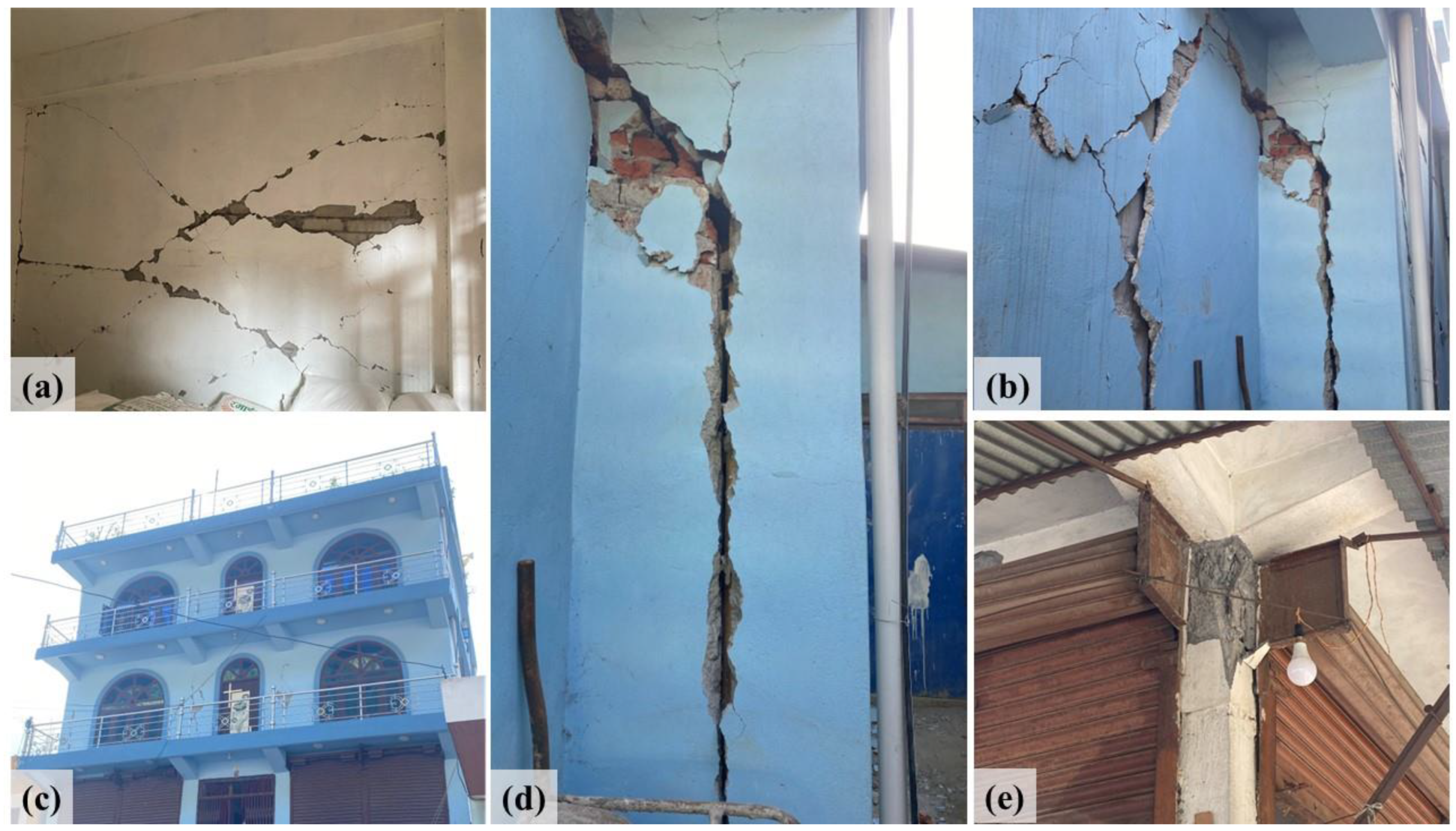
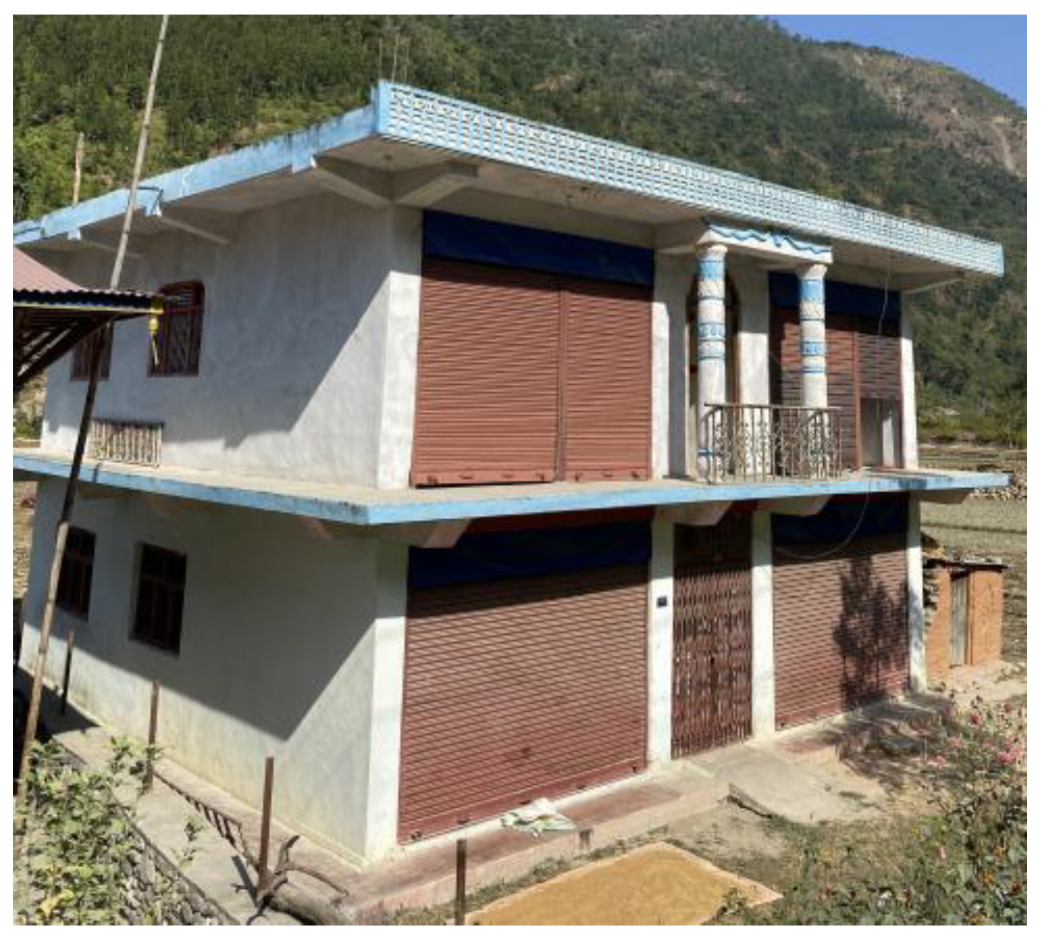
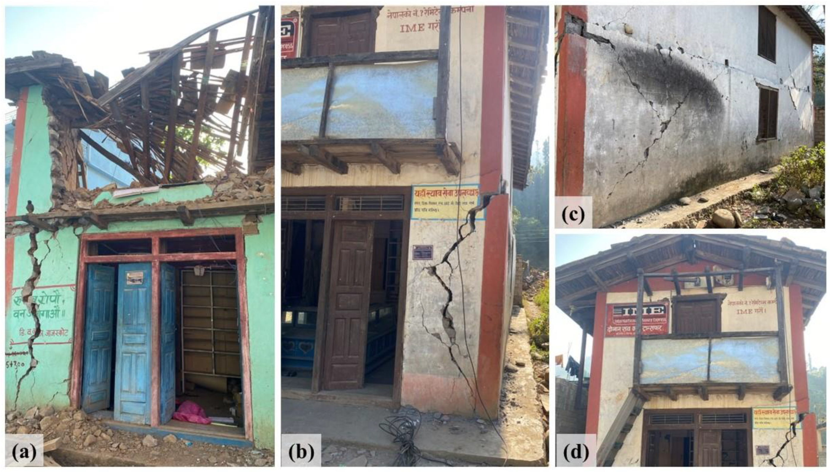
3.2.1. RC-Framed Buildings

RC-framed buildings were found mostly undamaged during the earthquake, exhibiting only minor damage in most cases. The damage seen in a two-story RC-framed building in Raut Gaun is demonstrated in Figure 6. It was clear that poor quality concrete was used in the construction of these damaged buildings. Examples of low-strength concrete used in RC buildings are shown in Figure 6c,d. The concrete in these buildings was easily disintegrated by hand. The strength of the concrete materials appears to have been severely weakened using large-diameter aggregates. Furthermore, the aggregates seemed to be poorly or uniformly graded, resulting in a honeycomb pattern in the cast concrete and further reducing its strength.
The four-story RC building located in Rimna Bazaar was damaged by the Jajarkot earthquake, as shown in Figure 7. Diagonal fissures on the brick infill wall of the building are depicted in Figure 7a. Furthermore, Figure 7b,d illustrate a poor connection by showing a noticeable space between the walls of the original structure and an attached expansion. These improper connections lead to the overall deformation of the main building because the extensions experience impact loads that cause severe damage. The strong beam and weak column connections are shown in Figure 7e. This type of connection is commonly found in RC buildings that have collapsed or sustained damage. Generally, when columns show weakness relative to beams, the overall ductility of the structure decreases. The weak column strong beam mechanism experiences a significant degradation in post-yield behavior, characterized by a significant loss of strength and limited displacement capacity. This emphasizes the vulnerability of buildings with strong beams and weak columns.
Further, the RC building with rolling shutters exhibited extensive damage attributed to column failure, as shown in Figure 7. During the installation of rolling shutters, the cover of RC columns is removed at specific locations along the column axis, revealing the primary reinforcement bars, which are then welded to the guide of the shutter. The introduction of rolling shutters markedly altered the stiffness and moment capacities of the RC columns by (1) diminishing the cross-sectional area of the column and (2) decreasing the strength and stiffness of the reinforcement bars due to overheating induced by the welding procedures. Similar observations were observed in the 2015 Gorkha earthquake in Nepal [7].
Nevertheless, the scale of damage sustained by RC buildings during the seismic event is comparatively limited when juxtaposed with their masonry counterparts. Despite the inadequate design and construction of most RC buildings in the region, they exhibited relatively good performance in this earthquake in comparison to masonry buildings, possibly due to the low peak ground acceleration (about 0.2 g) in the area. However, it is essential to dispel the misconception that RC buildings are inherently earthquake-resistant [32,33]. While reinforced concrete is a robust material, the earthquake resistance of a building relies on its proper design, following building codes, and the incorporation of seismic elements. Existing RC buildings (Figure 8) that do not adhere to the national building code should undergo retrofitting to ensure preparedness for future earthquakes.

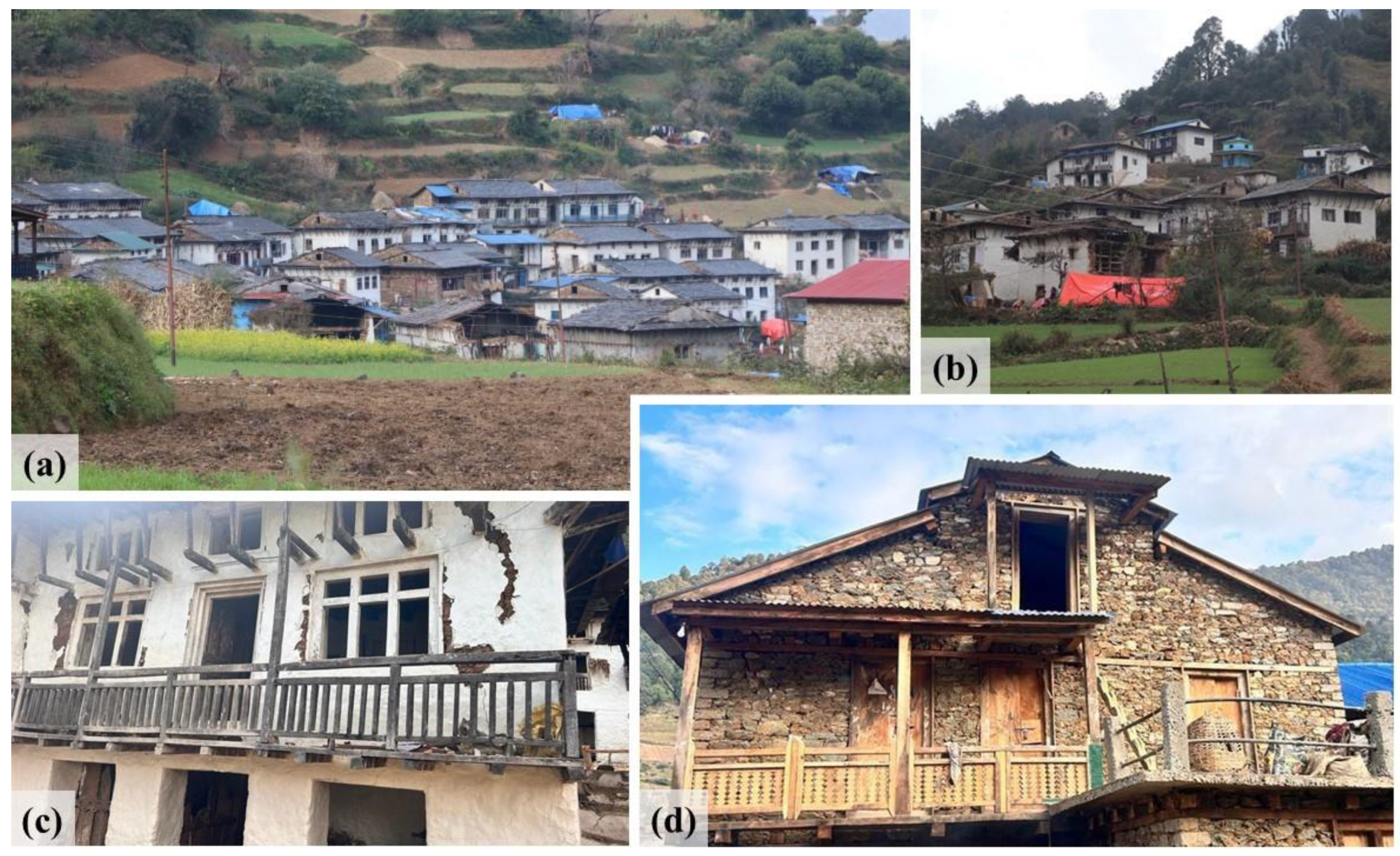
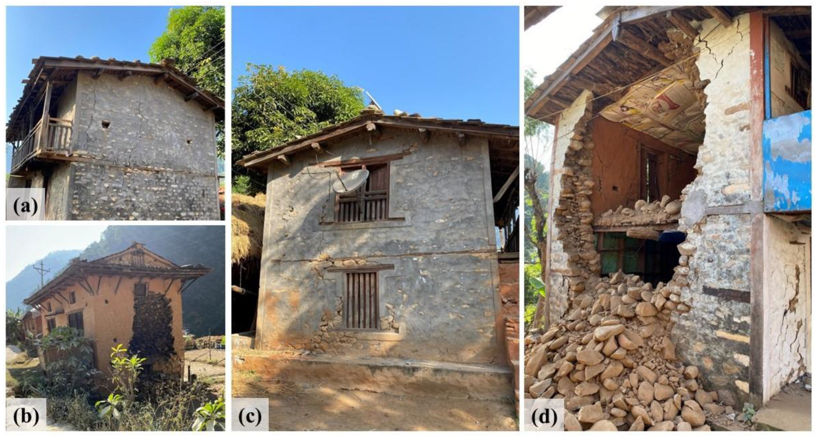
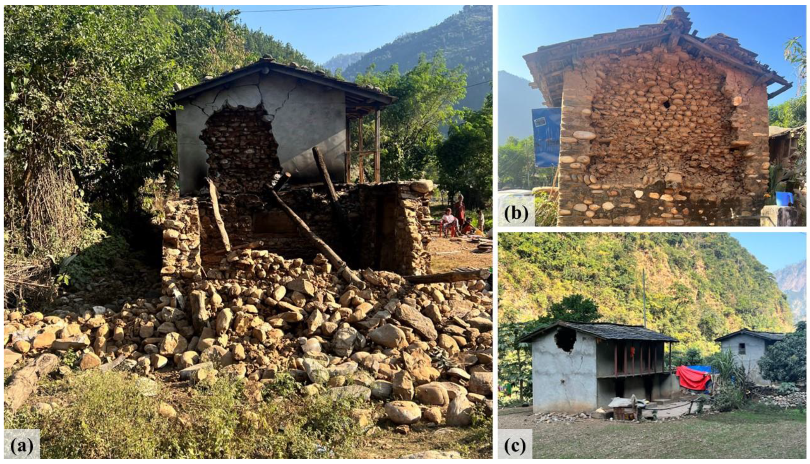
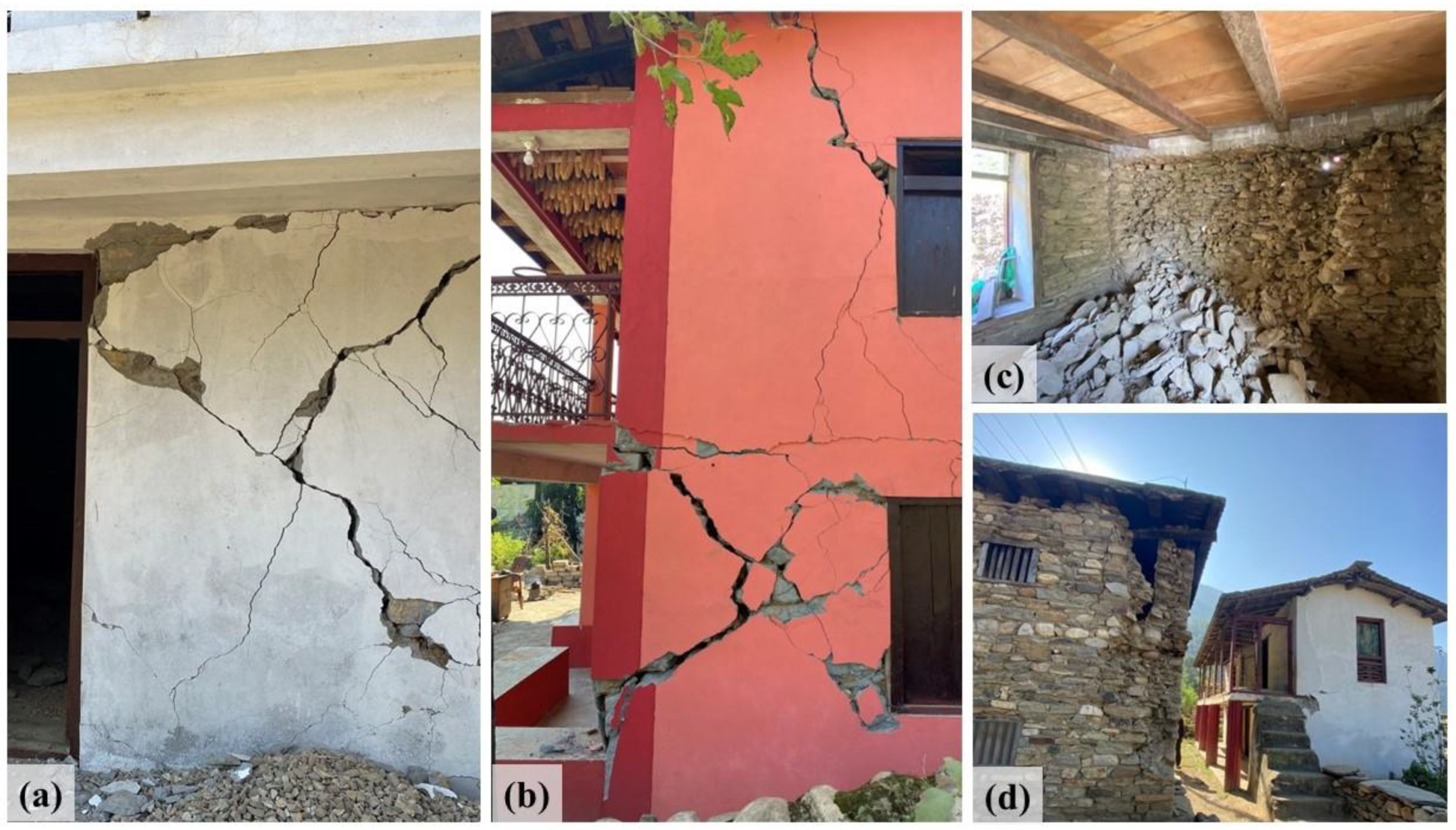
3.2.2. Masonry Buildings

Masonry structures are commonly used as load-bearing structures. These structures transfer load through their walls and are constructed by combining individual units such as bricks, stones, marble, or limestone with mortar. While masonry structures are efficient during production, construction, and operation, they lack effectiveness in resisting earthquakes due to insufficient reinforcement. Their low tensile strength and high compressive strength, combined with a lack of ductility, make load-bearing structures prone to failure during seismic events. The severity of damage to unreinforced masonry buildings in Nepal is evident in Figure 9, which depicts residential structures reduced to rubble in various locations of Jajarkot district due to the earthquake.
The dominant cause of damage in masonry structures is the use of weak mortar during construction [34]. In these buildings, unreinforced masonry is common, resulting in walls being disconnected from the floors and roofs as well as from each other. Typically, these structures lack earthquake-resistant elements such as corner stones and horizontal ties at various heights. As a result, even in mild seismic conditions, these buildings show notable weaknesses, leading to the formation of significant cracks, particularly in corners and around openings.
Some of the village’s structures that were destroyed by the earthquake are shown in Figure 10b,c. In the post-earthquake observation (Figure 10d), the Sherpa village construction showed a heightened safety level compared to neighboring settlements.
In general, buildings in the affected area had damage to their masonry walls, evident in the form of vertical or inclined shear cracks, as shown in Figure 11a,c. Figure 11b highlights the critical issue: the presence of cavities in the structural walls. These cavities seriously impair the capacity of walls to withstand flexural and shear stresses during seismic events, leading to damage. Additionally, when building thick walls, the use of small rubble rather than stones caused the wall to separate vertically. Figure 11d shows an out-of plane failure in the load-bearing structure. This causes the failure of one face of the wall and occurs due to the insufficient bonding between the adjacent walls. When the seismic wave travels along the crest surface, the face perpendicular to the direction of the seismic wave cannot generate significant lateral force. This happens because the wall facing the wave has a reduced width, resulting in a low moment of resistance. It was observed that gable walls are highly susceptible to drift and out-of-plane lateral loads, primarily because they function as unsupported infill walls detached from the roof structures. A significant cause of damage to unreinforced masonry buildings is the collapse of these gable walls. The failure of gable walls can potentially lead to the subsequent failure of the shorter lateral walls. Considering their poor performance under such conditions, it is advisable to replace stone masonry gable walls with lighter materials, such as wooden planks or steel sheets, as a recommended measure. This substitution aims to enhance the overall structural resilience and mitigate the risk of gable wall failure in the face of lateral loads.
It was evident that seismic forces generated during an earthquake have the potential to surpass the structural capacity of masonry, resulting in the development of cracks and separation at points vulnerable to such stress. The susceptibility of masonry walls to seismic forces is further heightened by insufficient reinforcement or suboptimal construction practices. Addressing these concerns necessitates the implementation of seismic retrofitting measures, which include the installation of appropriate lateral bracing, flexible connectors, and reinforcement elements. These measures are crucial for fortifying the earthquake resistance of masonry structures, effectively reducing the likelihood of separation, and safeguarding the overall integrity of the building in the event of seismic activity.
In Figure 12a, the failure of supporting walls and the collapse of the roof are recorded. Additionally, uneven foundation movement, inadequate connections between walls and floors, or out-of-plane bending brought on by seismic stresses perpendicular to the walls were also observed. Figure 12b illustrates observed failure and cracks at the corners, possibly stemming from these issues. The diagonal fractures in the masonry wall originating from the opening are shown in Figure 12c. The presence of apertures obstructs the load passage, leading to increased shear stress at lintel and sill levels, causing the formation of shear cracks. The poor connection between a stone masonry wall and the roof contributed significantly to structural failure during an earthquake. In seismic events, the dynamic forces exerted on a building can cause differential movement between the rigid stone masonry walls and the roof structure, especially if there is inadequate or improper anchoring and bracing. The lack of robust connections allowed for the independent movement of the wall and roof elements, leading to structural disintegration. The heavy mass of stone, combined with the brittle nature of the material, makes it particularly vulnerable to seismic forces. Without effective connections, the roof may have exerted additional stress on the stone masonry walls, leading to the development of cracks, separation at joints, or even the collapse of sections of the structure.
Additionally, Flexural out-of-plane failure is a major risk factor for unreinforced masonry structures, particularly in cases where there is a lack of proper wall-to-floor connection. This can lead to the collapse of entire wall panels or substantial sections when exposed to lateral seismic forces. The out-of-plane failure of load-bearing walls, caused by the failure of one wall face, is shown in Figure 13. This kind of collapse is made worse when there is inadequate bonding between neighboring walls, especially when seismic waves pass over the crest surface. The face perpendicular to the seismic wave experiences less lateral force due to its smaller breadth, resulting in a reduced moment of resistance. The disadvantages of employing rounded stone units are illustrated in Figure 13b, where it is shown how the smooth, rounded shapes of the units diminish bonding between them, allowing cracks to spread through weak mortar joints.
However, the Sherpa village, located 12 km from the epicenter and primarily composed of stone masonry structures with slate roofs made from flat, elongated quarry stones (Figure 10a,b), showed resilience in masonry structures as well. Notably, a major factor in supporting the overall structural stability of these buildings is the addition of timber bands at the lintel, sill, and roof levels. A timber band in a stone masonry building played a dual role, offering both structural stability and aesthetic enhancement. Positioned horizontally along the wall’s length with strategic intent, the timber band acts as a reinforcement, effectively distributing loads and resisting lateral forces such as wind or seismic loads. Its placement not only prevents wall spreading but also fosters structural continuity by connecting disparate sections of the wall, reducing the risk of cracking or bulging. Furthermore, the timber band serves as a sacrificial component, adept at absorbing movement and stress, thereby bolstering the overall durability of the structure. Beyond its structural contributions, the timber band introduces visual interest to the façade, breaking the monotony of the stone masonry and contributing a decorative element to the overall design of the building.
We can conclude that several factors contribute to the failure of stone masonry during earthquakes. Insufficient flexibility and poor mortar quality further exacerbate the vulnerability of stone masonry structures, as they are unable to adequately absorb and dissipate the energy generated during an earthquake. Lack of proper seismic design and reinforcement, including the absence of ties connecting different components of the masonry, can result in the disintegration of the structure. Common failure mechanisms include the development of diagonal shear cracks, vertical settlement, or the collapse of entire sections due to insufficient lateral support. The absence of horizontal ties connecting various elements of the masonry further compromises the building’s ability to withstand the lateral forces generated during seismic shaking. Further, the absence of thorough stones that span the entire thickness of the wall and help bind the masonry together reduces the wall’s overall cohesion and makes it more susceptible to seismic forces. The use of irregularly shaped stones can create weak points and hinder the uniform distribution of stress during an earthquake. Long, unsupported walls, lacking adequate lateral support, are prone to buckling or collapsing under the lateral forces generated by seismic shaking. Furthermore, the vertical height of the wall is crucial, as taller walls experience increased leverage and are more prone to overturning during seismic events.
The combination of these factors compromises the structural integrity of the stone masonry wall, leading to cracking, disintegration, or even catastrophic failure when subjected to the dynamic forces of an earthquake.
Hence, to enhance seismic resistance, it is imperative to incorporate proper construction practices, including through stones, regular-shaped stones, lateral bracing, and considerations for wall height, to mitigate the vulnerabilities associated with stone masonry structures in seismic zones. This study further warrants careful consideration of stone type, construction techniques, and adherence to seismic design principles.
In stone masonry using cement mortar, shear damage frequently causes the separation of perpendicular walls, as shown in Figure 14a,b. This is particularly prevalent in cases where cornerstones are missing, which usually give some support. Figure 14c shows the out-of-plane failure of a stone masonry wall, and Figure 14d shows a failure between the walls due to inadequate bonding, which causes walls to separate from one another. A leading factor contributing to these sorts of connection failures is the insufficient number of connections.

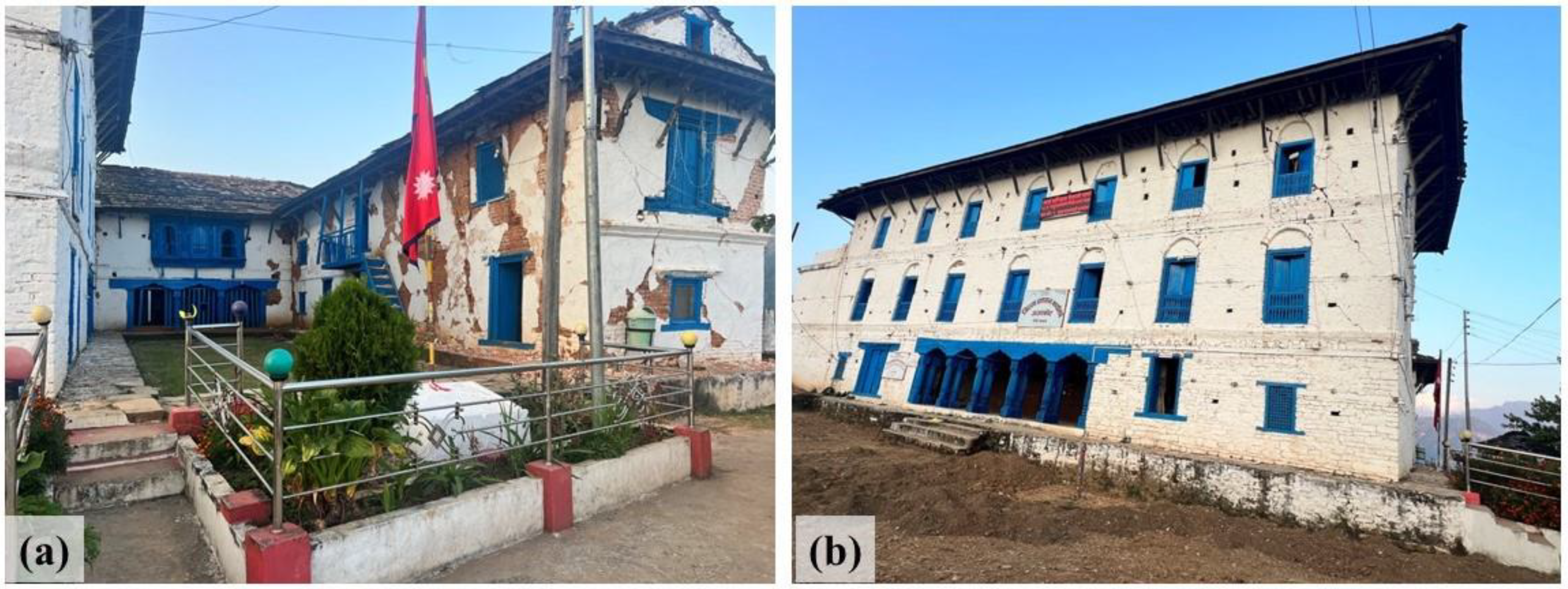
3.3. Heritage Structures

The Jajarkot Palace, an architectural and historical marvel constructed in 1825 B.S. by King of Jajarkot Hari Shah, suffered partial damage in the earthquake of 2023 (Figure 15). The minor damage could also be attributed to its recent retrofitting following the 2015 Gorkha earthquake. Popularly known as the ‘White Palace’, it holds immense cultural significance and is listed among the government’s designated tourist destinations. Unfortunately, the earthquake has not spared the nearby buildings of over a century in age, bearing historical value, as they too have incurred damage.
Corner wall collapses were seen at the heritage site, with the torsional effect being the primary cause of damage. The presence of step-type shear cracks in unreinforced masonry (URM) walls not only contributed to the separation at corners but also posed a risk to the overall structural integrity. A noteworthy exception was seen in the district administration office in Jajarkot, where the installation of a timber band on the roof and lintels played a crucial role in the stability of the building. This building managed to sustain comparatively less damage during the seismic event, showcasing the resilience provided by well-considered architectural elements, particularly the deliberate use of timber materials. This emphasizes the importance of intelligent design considerations in earthquake-prone regions.

3.4. Public Buildings

As of 20 November, the seismic event affected 898 school buildings; 294 sustained total damage, and 604 experienced partial damage. Additionally, 89 school toilets suffered partial damage due to the earthquake. This extensive destruction has directly impacted the education of 125,000 students [5]. An initial assessment carried out by the education cluster of Karnali Province identified that 65,867 students require urgent education assistance, including 5765 textbooks, to tackle the educational challenges brought up by the disaster. Figure 16 shows the damage suffered by the school infrastructure in Jajarkot and West Rukum districts due to the earthquake.
Among the 45 health institutions in Jajarkot, 6 experienced complete destruction and 12 experienced partial damage due to the earthquake. A total of 2 health institutions were completely damaged, while 22 experienced partial damage in West Rukum. Similarly, during the seismic occurrence, 3 health institutions were completely damaged in Salyan. Notably, a significant number of the affected health institutions were basic healthcare facilities, such as health posts in village areas. Understanding the pressing need for health care services during the emergency, five medical tents were set up in the required locations. These tents played a critical role in the restoration of maternal and newborn services in three municipalities.

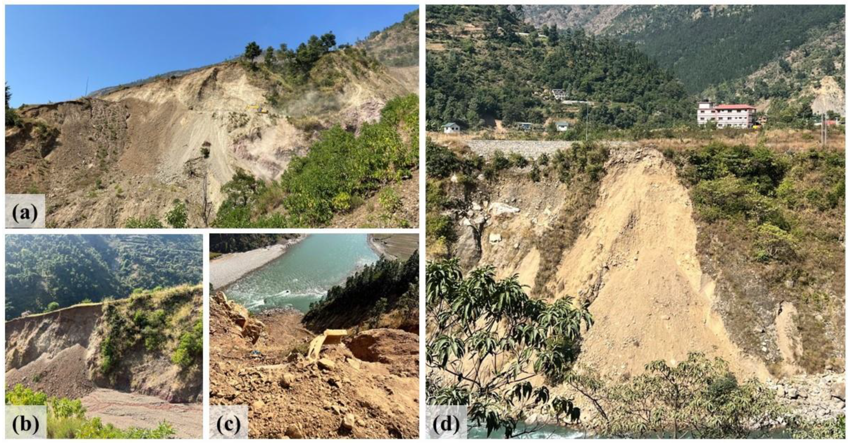
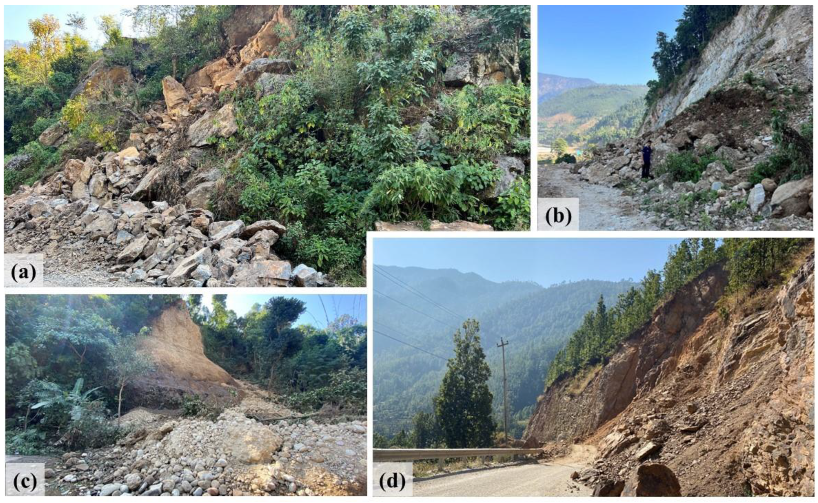
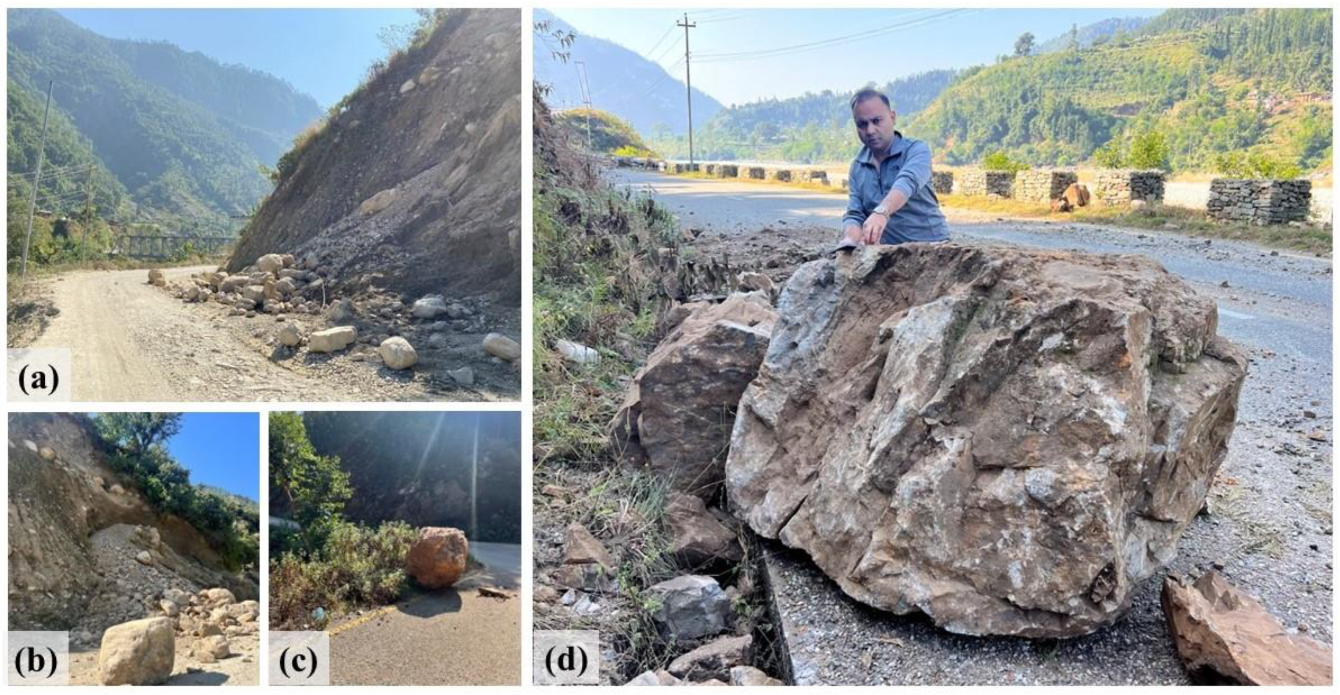
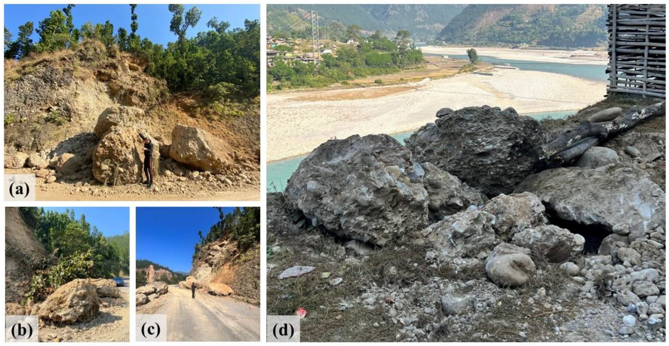
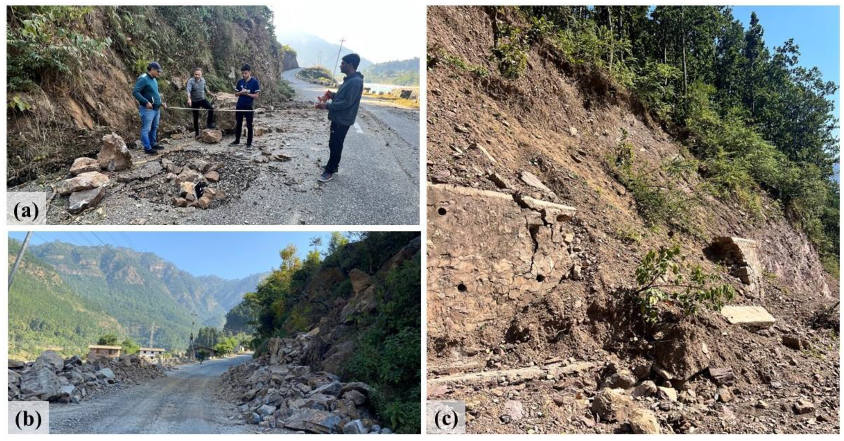
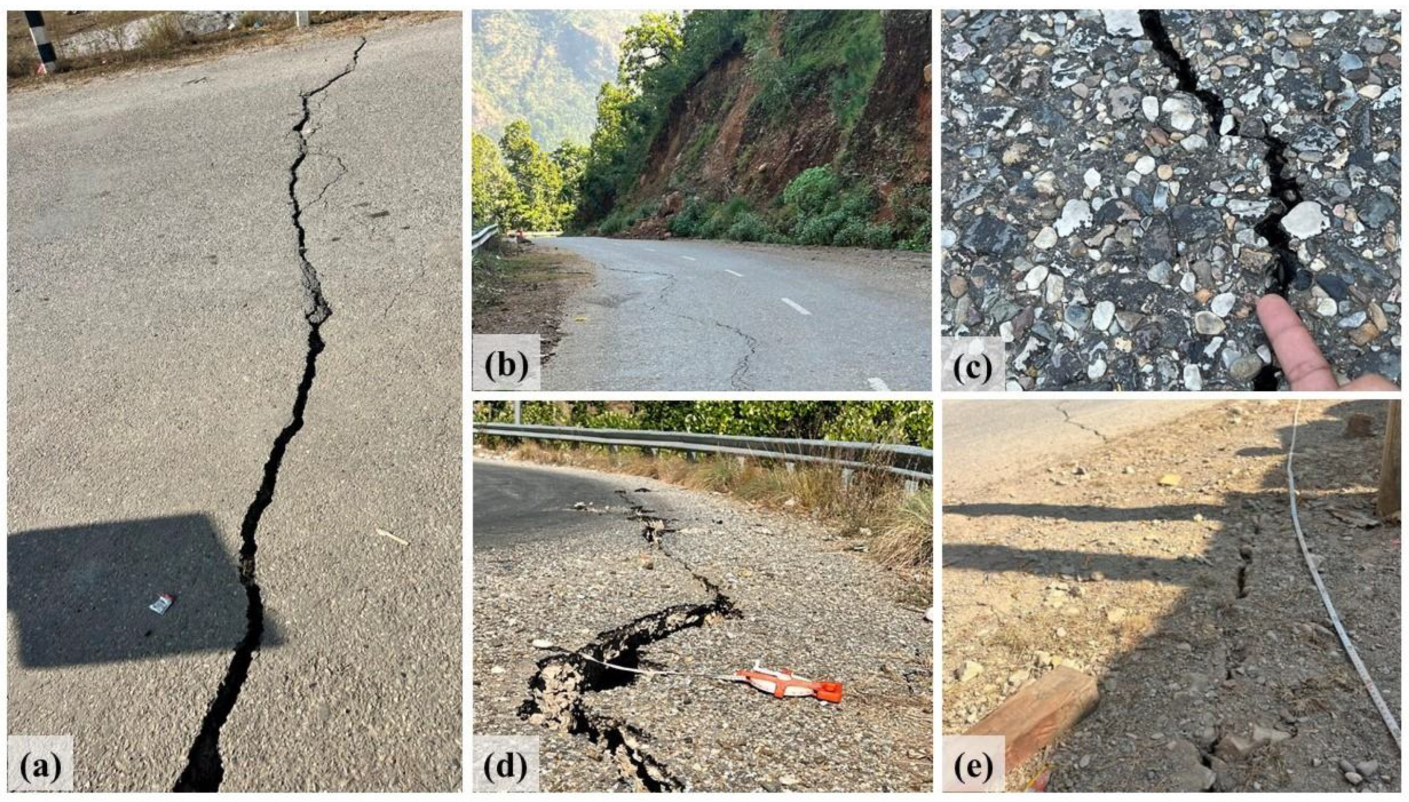
4. Seismically Induced Geotechnical Impacts

Though the earthquake was moderate, the shaking had caused significant seismo-induced environmental effects (i.e., co-seismic effects) like ground subsidence and fissures, rock falls, and landslides. The MW5.7 Jajarkot, Nepal earthquake can be classified as “VI—Slightly damaging-modest effects in the environment” based on the Environmental Seismic Intensity Scale (ESI 2007) [35]. No primary effects, such as surface faulting and tectonic uplift/subsidence, were observed. Secondary effects such as landslides, rockfalls, displaced boulders, ground subsidence, and fissures were manifested. Other secondary effects, such as liquefaction, changes in water quality and level, etc., were not observed. The study team recorded and analyzed these effects, especially on the Bheri corridor and Midhill Highway, to fully understand the geotechnical consequences. Figure 17 shows a route map of the location visited for the geotechnical impact assessment.
Earthquake-induced landslides damaged some sections of the Midhill Highway in West Rukum, from Chaurjahari to Rimna Bazar. Multiple rock falls and translational block slides rendered the passage of certain parts of the route difficult. Riverbank failures downslope posed additional obstacles to the highway’s integrity. Roadside structures were impacted by the landslips.
As shown in Figure 18a, a typical shallow landslide occurred on a steep slope near Nalgad Bazar. The debris was mostly composed of rocks, silt, and sand, as depicted in Figure 18b. Figure 18c shows the landslide that occurred along the lower section of the Midhill Highway close to China Bazar. An excavator was quickly mobilized to remove the obstruction caused by the landslide from the road. Furthermore, a shallow dry landslip near the Bheri Riverbank is seen in Figure 18d.
The earthquake-induced rockfalls on the road disrupted the smooth flow of traffic; however, temporary clearance of the road was undertaken during the survey period. In Figure 19a, an example of a weathered rock formation is depicted. Observations revealed rock masses of diverse sizes near the edge of the rockfall, suggesting the involvement of multiple rocks or the fragmentation of a primary boulder into smaller pieces as it descended the hill.
Rock falls were observed at various sections of the survey route, as shown in Figure 20. The rocks were of different sizes, varying from medium to large (0.5 to 5.8 m3) in the Bheri Corridor, as seen in Figure 20b. Along the Midhill highway, notably larger rockfalls, reaching sizes up to 1.73 m3, were observed, as shown in Figure 20d.
Substantial rocks of considerable size were discovered along the Bheri Corridor, as indicated in Figure 21a,c. These rocks exhibit a maximum size of approx. 5.8 m3. Additionally, Figure 21b,d depict rocks found alongside the Midhill Highway.
These rockfalls caused substantial damage to the road infrastructure, as depicted in Figure 22, leading to the formation of a large pothole in the pavement, measuring up to 1.8 × 2.3 m, as illustrated in Figure 22a. The resultant road blockage due to the rockfall along the Midhill highway is visible in Figure 22b. Additionally, Figure 22c showcases the collapse of retaining walls on a local road at Nalgad Bazaar along the roadside slope.
The earthquake inflicted structural damage on the road pavement, as illustrated in Figure 23. Figure 23a reveals a large transverse crack spanning the entire road, indicative of lateral ground movement during the seismic event. This type of cracking results from horizontal movement in the Earth’s crust, causing the pavement to fracture perpendicular to the road. Furthermore, Figure 23b displays longitudinal cracks with a maximum length of 120 m, suggesting shearing force or horizontal ground movement along the road during the earthquake.
The edge fracture and depression near China Bazaar, measuring 0.45 m in width and 1.82 m in depth, are shown in Figure 23d. This specific damage is attributed to the downslope slip phenomenon, in which seismic pressures weaken and fracture the pavement material at the margins, resulting in a sizable dip and edge crack. Figure 23e shows a diagonal crack near the Rimna Bridge, emphasizing the complex interaction between compressive and shearing forces during the earthquake-induced ground displacement.
The impact of earthquake-induced rockfalls and landslides is apparent in various sections. Figure 24 illustrates the earthquake’s effect on roadside concrete barriers along the Midhill highways in West Rukum. The 0.6 m high and 0.2 m wide concrete barrier suffered damage from falling boulders and debris, resulting in cracks, fractures, fissures, and dislodgments. This observed damage underscores the vulnerability of roadside infrastructure to seismic events, emphasizing the critical importance of targeted mitigation strategies and robust design in earthquake-prone areas like Nepal. More importantly, the study of KC et al. [36,37] highlights that the effect of earthquake preconditioning becomes apparent in the post-earthquake monsoon period, as evidenced by an increased rate of landslide disasters since the 2015 Gorkha earthquake. Thus, proper consideration of earthquake-affected vulnerable slopes is a must.
The terrain and soil of the area clearly had an impact on this earthquake. Figure 25 shows that the Jajarkot Khalanga ridge was the focal point of major infrastructure destruction, indicating the occurrence of topographic amplification. On the other hand, Kale Gaun, which is located on the hill’s lower slope, sustained little damage from the earthquake. A similar ridge effect was noted at Barekot, Limsa. As seen in Figure 2, most of the damaged places that were inspected, including Raut Gaun, Rimna Bazaar, Radi Bazaar, and Nalgad Bazaar, were established on river deposits and were situated along the Bheri River corridor. The substantial damage in these regions further indicated the impact of the local soil characteristics. Thus, the localized ground effects observed align with findings reported by [38,39,40] in other earthquake studies (Pohang Earthquake, Sonitpur Earthquake). Sharma et al. [23] have also discussed the similar effects of surface geology and topography on the damage severity during the 2015 Gorkha Nepal Earthquake.

5. Critical Infrastructures
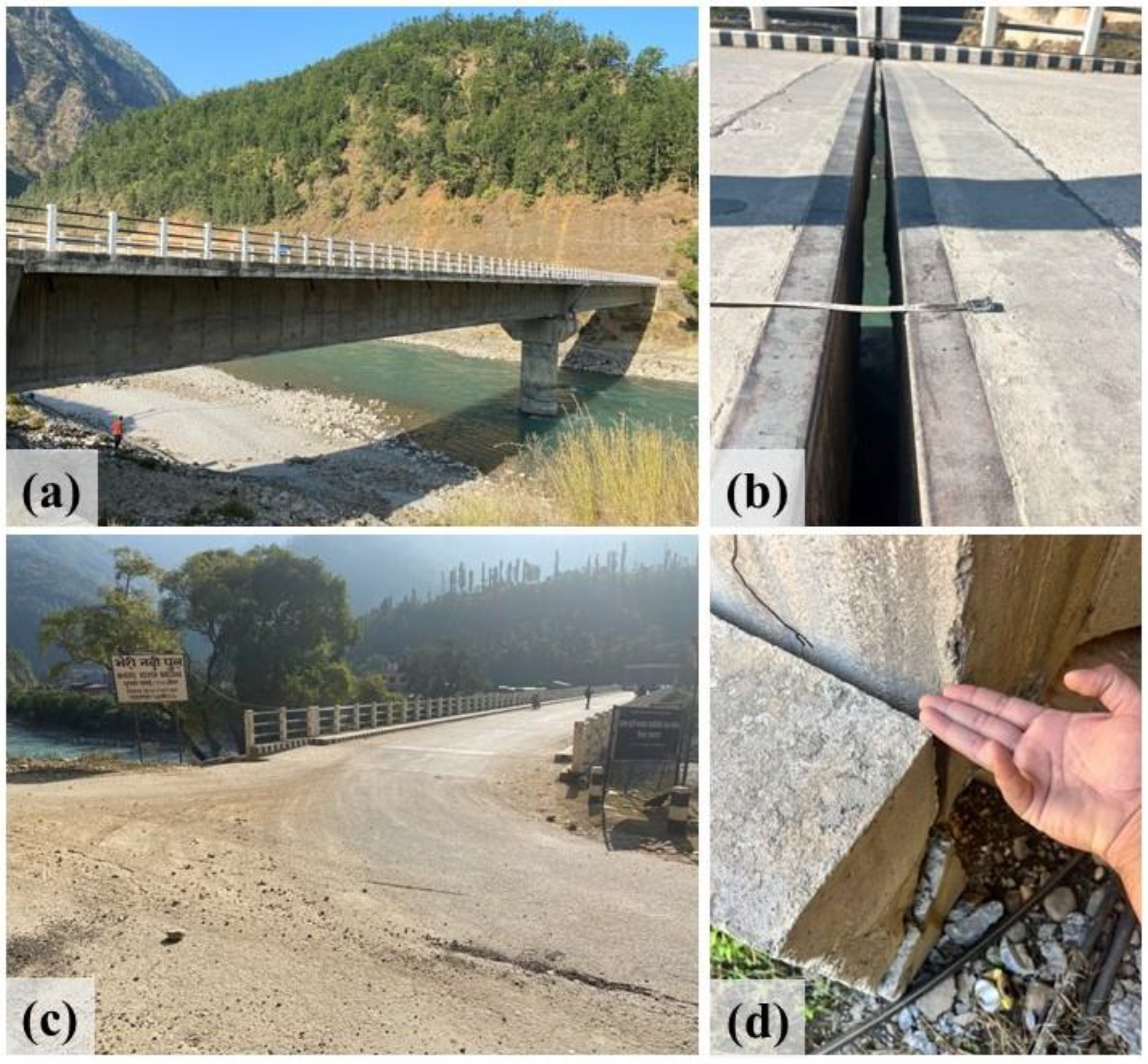
5.1. Bridges

The Bheri River bridge, located at Rimna Bazaar, connects the western and mid-western regions of the country along the Mid-hill highway and plays a crucial role in regional transportation. The bridge’s design includes two spans, each measuring 55.0 m, forming a simply supported prestressed box girder superstructure accommodating a double-lane carriageway with a 1.75 m footpath on each side, resulting in a total width of 11 m (Figure 26).
The reconnaissance visit revealed several observations about the bridge’s condition. The bridge utilizes POT-PTFE fix-free bearing arrangements, and despite broken bolts at both abutments, the superstructure securely remains on the bearings. Notably, rotational movement at the expansion joint was observed, causing a significant increase in the gap at the center and a reduction at the end of the left span. Additionally, the stoppers on the upstream side were found to be broken diagonally at both abutments due to the impact of the superstructure. Despite these issues, the abutment, pier, and superstructure displayed minor damage, with no observed cracks in critical structural components. However, the approach road exhibited various cracks, particularly in the backfill of the abutments and the natural ground in the United Region. The inspection highlighted specific concerns, including broken bolts, rotational movement at the expansion joint, and damage to stoppers, emphasizing the immediate need for a bearing replacement plan followed by correcting the superstructure’s dislocation.

5.2. Communication Structures

Following the earthquake, Nepal Telecom and Ncell mobile networks were operational in most of the affected regions. According to the Association of Community Radio Broadcasters Nepal (ACORAB), three radio stations in Jajarkot and West Rukum have suffered significant infrastructure damage, while four other radio stations have suffered partial damage, including building cracks and equipment impairments. The five most impacted radio stations in West Rukum and Jajarkot districts received support such as laptops, microphones, mixers, internet backup, headphones, hybrid phones, and protective gear like helmets to continue community radio broadcasting.

5.3. Dams and Water Structures

The seismic activity resulted in some damage to reservoirs and intake infrastructure, leading to minor leaks and cracks that impacted the water supply’s sufficiency. According to the reporting of the District Administration Office, while the water supply experienced a temporary interruption for nine days, it was promptly rehabilitated after identifying damage to the supply pipe from the source near Khalanga caused by a landslide. Although the damage was not severe, addressing the fragile and damaged state of many pre-existing water supply systems in earthquake-affected areas remains crucial to prevent potential WASH (Water, Sanitation, and Hygiene) and health issues in the future.

6. Post Disaster Responses

Following the Jajarkot Earthquake in 2023, the Nepalese government responded promptly to the crisis. Security forces were swiftly dispatched to the affected area, and helicopters delivered humanitarian aid while soldiers worked to clear blocked roads. A total of 915 Nepal Army personnel, 854 Nepal Police, and 395 Armed Police Force were deployed for search, rescue, and relief activities. Search and rescue operations concluded 36 h after the earthquake, shifting focus to providing assistance to survivors. Nepalgunj Hospital allocated over 100 beds for earthquake victims, and search and rescue teams diligently removed landslide debris to ensure access to affected regions.
Both President Ram Chandra Poudel and Prime Minister Pushpa Kamal Dahal actively engaged in the crisis, expressing deep sorrow. The government allocated a Rs 100 million fund for search and rescue operations, providing financial aid and free medical treatment to victims. Additionally, 2040 blankets and 72 tents provided by the Chinese government were transported to Jajarkot, with an additional 1840 blankets and 72 tents transported to Rukum West.
Nepal Telecom played a crucial role by offering free communication services to facilitate information exchange. Internationally, countries including Bangladesh, China, India, Iran, Pakistan, Russia, and South Korea expressed solidarity and offered assistance. UNICEF collaborated with partner organizations to assess the damage and impact on children and families, contributing to the global effort to address the humanitarian crisis triggered by the earthquake.

6.1. Intermediate Shelters and Reconstruction

Following the earthquake’s impact, individuals and various organizations swiftly visited the site, providing immediate relief materials such as food, and some engaged in constructing temporary transition shelters, drawing on lessons learned from the 2015 earthquake. Recognizing the urgent need for immediate temporary housing for affected families whose private residences were completely or partially damaged, the government promptly approved the “Temporary Housing Construction Grant Procedure for Earthquake-Affected Households 2080.” This framework ensures the efficient utilization of funds for constructing temporary housing, facilitating a rapid and effective response.
Under this initiative, the government granted support of Nepali Rupees (NPR) 50,000 in two installments (NPR 25,000 each) for constructing temporary housing. The allocated grant was disbursed from the District Disaster Management Committee (DDMC) Fund to the Local Disaster Management Committee (LDMC). Substantial amounts of NPR 5 crore each were released to Jajarkot and Rukum West to provide relief to those affected by the earthquake, supporting recovery and reconstruction efforts. Funds were also allocated for expenses related to transportation for rescue efforts, communication, storage, packing, and other necessities. Additionally, the government provided NPR 50,000 to earthquake-affected families for the construction of temporary housing. In Jajarkot District, a total of 132 tents, 32,218 tarpaulins, 24,322 blankets, 2267 mattresses, 9132 rice sacks, and 17,389 kg of lentils were distributed, addressing immediate needs. Similarly, in Rukum West, essential relief items, including 489 tents, 18,977 tarpaulins, 10,737 blankets, 2091 mattresses, 6387 sacks of rice, and 6387 kg of lentils, were distributed to assist the affected population.
In the case of Jajarkot and Rukum West, NPR 10 lakh was allocated for immediate response activities to protect the lives and well-being of vulnerable individuals. Additionally, NPR 5 lakh was allocated for debris removal and carcass management. Furthermore, NPR 25 lakh was expended on essential rescue and relief works, including the storage, packaging, and transportation of relief materials.
In Salyan district, NPR 5 lakh was allocated for immediate response activities to safeguard the lives of potentially vulnerable individuals. Additionally, NPR 3 lakh can be allocated for debris removal and carcass management. Furthermore, NPR 10 lakhs can be expended on necessary rescue and relief works, including the storage, packaging, and transportation of relief materials.
To ensure a coordinated and effective response, the National Disaster Risk Reduction and Management Authority (NDRRMA) collaborated with the Ministry of Urban Development (MoUD). Their joint efforts focused on conducting detailed damage assessments and evaluations, as well as managing the necessary human resources for the retrofitting, reconstruction, and rehabilitation of private housing and public buildings and structures damaged by the earthquake.

6.2. Challenges

The Jajarkot earthquake occurred right after the lengthy and humongous reconstruction carried out by the Nepali government post Gorkha Earthquake. It is essential to recognize that the existing institutional setup of NDRRMA, with the experience of post-disaster reconstruction brings great value; however, it is equally imperative to duly acknowledge the failures and challenges encountered in the process. Inconsiderate and disorganized planning amongst actors, such as governments, NGOs, donors, and beneficiaries, commonly leads to duplication, inefficiency, and conflicts [41]. However, considering the present robust institutional setup to overview the rescue and reconstruction process and the strong presence of elected local government, which also showed its importance during the emergency response, we would like to focus our analysis of challenges only on two aspects of reconstruction: socio-economic and technical.

6.2.1. Socio-Economic Challenges

Post-disaster reconstruction is a complex and challenging process involving multiple actors, stakeholders, and socio-cultural dimensions of the affected group. Hence, addressing disaster recovery requires transcending the traditional priority of physical reconstruction to encompass social, cultural, economic, and psychological dimensions [42]. This is especially significant in Jajarkot, Rukum, and Salyan, where the region’s Human Development Index (HDI) is 0.39, 0.43, and 0.44, respectively, falling below the national average of 0.49 [43]. Most of the family relies on agriculture and rural livelihood, which requires special attention when proposing the reconstruction of houses. In many instances, crucial socio-cultural factors tend to be overlooked, including the diversity of various groups, their participation in decision-making, and, in some cases, their disregard for their human rights and dignity [42]. It is also crucial to ensure the active involvement of and expression of ideas from people affected, reflecting on the significance of procedural justice in the reconstruction process [44]. Considering the difficult terrain of the impacted regions, it is quite possible that policymakers will propose relocation plans; however, such plans should be considered with a greater level of scrutiny based on social and economic context of the region, as various studies have found, relocation plans in post-disaster housing have resulted in the loss of livelihood for communities [45] and lesser satisfaction for the people. Post-disaster housing reconstruction stands as a pivotal element in the broader recovery process, serving the crucial function of ensuring safe and secure shelter for affected individuals and communities. Hence, this reconstruction should be perceived not merely as a product but as a dynamic process, wherein survivors are not passive victims but active agents in shaping their recovery [46].

6.2.2. Building-Reconstruction Challenges

Out of the experience of the Nepal government with the owner-driven reconstruction process from the Gorkha Earthquake, it would be obvious that a new reconstruction approach would also follow the same. As various studies and reports from international communities, such as the Red Cross and the World Bank, have vouched for owner-driven reconstruction, it does not come without flaws. Lam [46] has carried out a detailed longitudinal assessment of post-disaster housing in Nepal, evaluating the satisfaction of people after the reconstruction. Her study showed that less than 30% of people could imply traditional elements and argues that the whole owner-driven reconstruction (ODR) was guided by a donor-led, expert-based design without much consideration for the livelihood of people. The earlier reconstruction faced significant challenges because of the rigidity of the model houses, hindering the ability to tailor homes to the unique needs of individual families and reflecting on their livelihoods and family structures. In this case, learning from the reconstruction after the Kashmir Earthquake in Pakistan could be handy. Even with the similar challenges of reconstruction in Nepal, such as difficult terrain, weak financing, a lack of technical knowledge and manpower on the ground, and many more, the flexibility adopted by the authorities through local bodies in handling the ground issues resulted in efficient and effective reconstructions [47]. Further, it is also crucial to recognize that the lack of human resources in the difficult terrain of the far western part of Nepal and the lack of availability of building materials could result in price hikes, as we noticed earlier. Sharma et al. [48,49] and Acharya et al. [50,51] have drawn attention to the persistent challenges of post-disaster reconstruction in Nepal, like bureaucratic burdens on implementation and the vested interests of some parties resulting in corruption, reflecting on the fragile governance of Nepal.

7. Conclusions and Lessons Learned

The reconnaissance study was conducted three days after the 2023 Jajarkot earthquake (ML6.4) to assess initial damage observations. Additionally, the study team engaged with individuals involved in the process to comprehend the challenges in immediate relief and to plan for post-disaster reconstruction. Based on the initial survey, the study team has drawn the following conclusions and provided recommendations. These findings can be valuable for further research in the region and serve as insights for policymakers to comprehend the situation.
  • This study revealed that most of the buildings were non-engineered. It also showed that there were no substantial initiatives taken to implement the code in the region.
  • The level of damage in RC structures is comparatively lower than that in masonry buildings, potentially due to the lower intensity of ground shaking. However, the damage observed in these non-engineered RC structures stems from irregular structural configuration, inadequate design and detailing, and the use of substandard construction materials and practices. Addressing these issues underscores the need for a regulatory framework from the government to ensure earthquake resistance in the built environment.
  • The damage to masonry buildings resulted from factors such as inadequate construction detailing, subpar masonry material properties, irregularly shaped stones with smooth surfaces, weak structural walls, unconfined gable walls, and cracks at the corners of windows and doors. Implementing minimum reinforcement measures, such as through stones in the walls or horizontal and vertical bands, proved to be effective in enhancing the seismic performance of masonry buildings.
  • In contrast, stone masonry structures in a Sherpa village near the epicenter showed enhanced stability, attributed to the addition of timber bands at various levels, underscoring the significance of thoughtful architectural elements in earthquake-prone regions.
  • The earthquake significantly impacted the education sector, with 898 school buildings affected, causing disruptions for 125,000 students and highlighting the urgent need for reconstruction and support.
  • The earthquake resulted in extensive destruction in mountainous areas, triggering minor to major landslides that, at times, blocked roads and isolated villages. Strengthening Nepal’s local transportation network is essential to enhancing the resilience of rural communities.
  • Rockfalls, landslides, and road damage were evident, underscoring the significance of implementing effective landslip mitigation techniques, robust road design, and the necessity for targeted strategies in earthquake-prone areas.
  • Regardless of earthquake magnitude and intensity, seismo-induced environmental effects such as landslides, rockfall, ground subsidence, and fissures can significantly impact the assessment of seismic hazards by altering the dynamic response of structures and terrain. These effects can pose challenges in accurately predicting ground motion and structural behavior, influencing the seismic vulnerability of a region. Consequently, post-reconstruction efforts must consider these environmental factors to enhance resilience and mitigate potential seismic risks effectively.
More specifically, researchers and practitioners in seismology and the structural performance of infrastructure and buildings can draw several insights from this earthquake, particularly concerning rural construction technologies and earthquake-induced hazards. They can learn the following lessons from the earthquake:
  • Strict adherence to mandatory rules of thumb (MRT) and building code implementation are essential, along with the provision of technical support for new construction. Standard practices for earthquake safety should be widely disseminated in a format that is easily accessible and actionable at the implementation level.
  • A sufficient and reliable network of strong ground motion instruments should be installed so that a comprehensive study of ground motion and the response of structures can be known for the study of what structures can be designed for those areas.
  • In Himalayan terrain, the construction of new unreinforced masonry (URM) structures should be prohibited, and retrofitting measures for critical, lifeline, and government structures should be enforced.
  • The present study and research are mostly focused on advancing construction material types and technology. However, to ensure sustainability and preserve traditional technology, it is now also necessary to redirect our research efforts towards our indigenous technology and methodologies.
  • Many affected areas lack accessibility to market areas, making the transportation of construction materials such as cement, reinforcement bars, and aggregate challenging. Promoting local building technology in Nepal not only preserves the rich history of Nepali construction but also showcases resilience to various weather conditions, ensuring cultural preservation and adaptability to diverse environments. This enhances scenic aesthetics, addresses economic and transportation aspects by boosting the regional economy, reducing reliance on external resources, and promoting sustainability in building methodologies. Additionally, involving the local community in the empowerment process through training and awareness is essential. Without this local engagement, disaster risk reduction or resilience efforts may remain mere slogans on paper, destined for ineffectiveness.
  • Mobilizing post-earthquake damage assessment teams with impartial judgment on the usability of damaged structures is crucial. Additionally, technical information should be disseminated to professional architects and engineers regarding accepted methods for the assessment and retrofit of damaged structures, utilizing the experience gained from the 2015 Gorkha earthquake.
  • Further, disaster reconstruction should adopt flexible designs adaptable to diverse contexts, considering geographical, cultural, and socioeconomic variations. Prioritizing social equity is crucial to ensuring inclusive support for vulnerable groups. This approach enhances reconstruction effectiveness, fosters resilience, and promotes long-term community well-being.
The Jajarkot Earthquake serves as a warning for the anticipated larger disaster, according to various researchers. Swift action on lessons learned, retrofitting buildings, and upgrading infrastructure in the region can yield significant benefits. Post-disaster reconstruction and damage assessments represent initial steps toward building a resilient community, aiming to avoid the mistakes and shortcomings observed in the aftermath of the 2015 Gorkha Earthquake. While residents will remember this earthquake as one that caused loss of life, building damage, landslides, and destroyed heritage structures, earthquake professionals/practitioners see it as a warning before the big one strikes.

Author Contributions

Conceptualization, M.S., R.K., and K.S.; methodology, M.S. and K.S.; software, R.K.; validation, M.S., R.K., and K.S.; formal analysis, R.K.; investigation, R.K. and A.K.; resources, M.S., K.S., and J.M.; data curation, R.K. and A.K.; writing—original draft preparation, M.S., R.K., and J.M.; writing—review and editing, K.S. and A.K.; visualization, R.K. and K.S.; supervision, M.S. and K.S.; project administration, M.S. and J.M. All authors have read and agreed to the published version of the manuscript.

Funding

This research received no external funding.

Data Availability Statement

No new data were created or analyzed in this study. Data are contained within the article.

Acknowledgments

On behalf of the authors, sincere gratitude is extended to the Ministry of Home Affairs (MoHA), Department of Roads (DoR), and Nepal Geotechnical Society (NGS) for their steadfast support throughout this research endeavor. Special thanks are conveyed to Prabhat Kumar Jha for providing indispensable guidance and support; Udaya Raj Neupane for facilitating coordination; Sujan Adhikari, Tejaswi Sharma, and Abinash Aryal for offering invaluable on-site support; and Gokarna Bahadur Motra for contributing to discussions on structural aspects. We also acknowledge Lok Bijaya Adhikari and the Department of Mines and Geology (DMG) for providing accelerogram data and seismological information. The authors express their appreciation to Lokendra Budha for providing photos of epicenter areas and Richa Pokhrel for her contributions to the documentation process. The collaborative effort has been significantly enhanced by the collective support of these esteemed institutions and individuals.

Conflicts of Interest

The authors declare no conflicts of interest.

References

  1. USGS. M5.7-44 km E of Dailekh, Nepal; United States Geological Survey: Reston, VA, USA, 2023.
  2. Ader, T.; Avouac, J.P.; Liu-Zeng, J.; Lyon-Caen, H.; Bollinger, L.; Galetzka, J.; Genrich, J.; Thomas, M.; Chanard, K.; Sapkota, S.N.; et al. Convergence rate across the Nepal Himalaya and interseismic coupling on the Main Himalayan Thrust: Implications for seismic hazard. J. Geophys. Res. Solid Earth. 2012, 117, B4. [Google Scholar] [CrossRef]
  3. Paudyal, H.; Shanker, D.; Singh, H.; Panthi, A.; Kumar, A.; Singh, V. Current understanding of the seismotectonics of Western Nepal Himalaya and vicinity. Acta Geod. Geophys. Hung. 2010, 45, 195–209. [Google Scholar] [CrossRef]
  4. Angster, S.; Fielding, E.J.; Wesnousky, S.; Pierce, I.; Chamlagain, D.; Gautam, D.; Upreti, B.N.; Kumahara, Y.; Nakata, T. Field reconnaissance after the 25 April 2015 M 7.8 Gorkha earthquake. Seismol. Res. Lett. 2015, 86, 1506–1513. [Google Scholar] [CrossRef]
  5. UNICEF. UNICEF Nepal Humanitarian Situation Report No. 3 (Earthquake): 20 November 2023. 2023. Available online: https://reliefweb.int/report/nepal/unicef-nepal-humanitarian-situation-report-no-3-earthquake-20-november-2023 (accessed on 1 December 2023).
  6. Goda, K.; Kiyota, T.; Pokhrel, R.M.; Chiaro, G.; Katagiri, T.; Sharma, K.; Wilkinson, S. The 2015 Gorkha Nepal Earthquake: Insights from Earthquake Damage Survey. Front. Built Environ. 2015, 1, 8. [Google Scholar] [CrossRef]
  7. Sharma, K.; Deng, L.; Noguez, C.C. Field investigation on the performance of building structures during the April 25, 2015, Gorkha earthquake in Nepal. Eng. Struct. 2016, 121, 61–74. [Google Scholar] [CrossRef]
  8. Subedi, M.; KC, R.; Acharya, I.P. SPT-based seismic soil liquefaction potential evaluation of Kathmandu Valley using first-order second-moment method. In Proceedings of the GeoNiagara Conference 2021, Niagara Falls, ON, Canada, 26–29 September 2021. [Google Scholar]
  9. Acharya, I.P.; Subedi, M.; KC, R. Liquefaction Hazard Assessment of Kathmandu Valley Using Deterministic and Probabilistic Approaches. In Proceedings of the Geo-Risk 2023, Arlington, VA, USA, 23–26 July 2023; pp. 307–317. [Google Scholar] [CrossRef]
  10. Gautam, D.; Chaulagain, H. Structural performance and associated lessons to be learned from world earthquakes in Nepal after 25 April 2015 (MW 7.8) Gorkha earthquake. Eng. Fail. Anal. 2016, 68, 222–243. [Google Scholar] [CrossRef]
  11. Sharma, K.; Deng, L. Reconnaissance Report on Geotechnical Engineering Aspect of the 2015 Gorkha, Nepal, Earthquake. J. Earthq. Eng. 2017, 23, 512–537. [Google Scholar] [CrossRef]
  12. Kc, A.; Sharma, K.; Pokharel, B. Performance of Heritage Structures during the Nepal Earthquake of April 25, 2015. J. Earthq. Eng. 2017, 23, 1346–1384. [Google Scholar] [CrossRef]
  13. Sharma, K.; Deng, L.; Khadka, D. Reconnaissance of liquefaction case studies in 2015 Gorkha (Nepal) earthquake and assessment of liquefaction susceptibility. Int. J. Geotech. Eng. 2017, 13, 326–338. [Google Scholar] [CrossRef]
  14. Rai, D.C.; Singhal, V.; Raj S, B. Reconnaissance of the effects of the M7.8 Gorkha (Nepal) earthquake of April 25, 2015. Geomat. Nat. Hazards Risk 2016, 7, 1–17. [Google Scholar] [CrossRef]
  15. Hashash, Y.M.; Tiwari, B.; Moss, R.E.S.; Asimaki, D.; Clahan, K.B.; Kieffer, D.S.; Dreger, D.S.; Macdonald, A.; Madugo, C.M.; Mason, H.B.; et al. Geotechnical Field Reconnaissance: Gorkha (Nepal) Earthquake of April 25, 2015 and Related Shaking Sequence; Geotechnical Extreme Event Reconnaisance GEER Association Report No. GEER-040, August 2015. Available online: https://digitalcommons.calpoly.edu/cenv_fac/311 (accessed on 5 December 2023).
  16. Okamura, M.; Bhandary, N.P.; Mori, S.; Marasini, N.; Hazarika, H. Report on a reconnaissance survey of damage in Kathmandu caused by the 2015 Gorkha Nepal earthquake. Soils Found. 2015, 55, 1015–1029. [Google Scholar] [CrossRef]
  17. Ghazoui, Z.; Bertrand, S.; Vanneste, K.; Yokoyama, Y.; Nomade, J.; Gajurel, A.P.; van der Beek, P.A. Potentially large post-1505 AD earthquakes in western Nepal revealed by a lake sediment record. Nat. Commun. 2019, 10, 2258. [Google Scholar] [CrossRef] [PubMed]
  18. Srivastava, H.; Verma, M.; Bansal, B.; Sutar, A.K. Discriminatory characteristics of seismic gaps in Himalaya. Geomat. Nat. Hazards Risk 2013, 6, 224–242. [Google Scholar] [CrossRef]
  19. Koukouvelas, I.K.; Nikolakopoulos, K.G.; Kyriou, A.; Caputo, R.; Belesis, A.; Zygouri, V.; Verroios, S.; Apostolopoulos, D.; Tsentzos, I. The March 2021 Damasi Earthquake Sequence, Central Greece: Reactivation Evidence across the Westward Propagating Tyrnavos Graben. Geosciences 2021, 11, 328. [Google Scholar] [CrossRef]
  20. Mercimek, Ö. Seismic failure modes of masonry structures exposed to Kahramanmaraş earthquakes (Mw 7.7 and 7.6) on February 6, 2023. Eng. Fail. Anal. 2023, 151, 107422. [Google Scholar] [CrossRef]
  21. Markušić, S.; Stanko, D.; Korbar, T.; Belić, N.; Penava, D.; Kordić, B. The Zagreb (Croatia) M5.5 Earthquake on 22 March 2020. Geosciences 2020, 10, 252. [Google Scholar] [CrossRef]
  22. Sharma, K.; Subedi, M.; Acharya, I.P.; Pokharel, B. Geotechnical and Structural Aspect of 2015 Gorkha Nepal Earthquake and Lesson Learnt. J. Inst. Eng. 2018, 13, 20–36. [Google Scholar] [CrossRef]
  23. Sharma, K.; Subedi, M.; Parajuli, R.R.; Pokharel, B. Effects of surface geology and topography on the damage severity during the 2015 Nepal Gorkha earthquake. Lowl. Technol. Int. 2017, 18, 4. [Google Scholar]
  24. Subedi, M.; Sharma, K.; Acharya, I.P.; Adhikari, K. Liquefaction of soil in Kathmandu Valley from 2015 Gorkha, Nepal. Nepal Eng. Assoc. Tech. J. Spec. Issue Gorkha Earthq. 2018, 2015, 108–116. [Google Scholar]
  25. Chiaro, G.; Kiyota, T.; Pokhrel, R.M.; Goda, K.; Katagiri, T.; Sharma, K. Reconnaissance report on geotechnical and structural damage caused by the 2015 Gorkha Earthquake, Nepal. Soils Found. 2015, 55, 1030–1043. [Google Scholar] [CrossRef]
  26. Avouac, J.-P.; Meng, L.; Wei, S.; Wang, T.; Ampuero, J.-P. Lower edge of locked Main Himalayan Thrust unzipped by the 2015 Gorkha earthquake. Nat. Geosci. 2015, 8, 708–711. [Google Scholar] [CrossRef]
  27. NBC 105:2020; Seismic Design of Buildings in Nepal. Nepal Government: Kathmandu, Nepal, 2020.
  28. Nepal Engineers’ Association. Seismicity and Seismotectonic related to Jajarkot Earthquake 2023′, a Lecture by Dr. Lok Bijaya Adhikari on December 8, 2023. 2023. Available online: https://www.youtube.com/watch?v=RjmdY_Ph5Uk (accessed on 9 December 2023).
  29. CBS. National Population and Housing Census 2021; National Report; National Statistics Office: Kathmandu, Nepal, 2021.
  30. Chaulagain, H.; Gautam, D.; Rodrigues, H. Revisiting Major Historical Earthquakes in Nepal: Overview of 1833, 1934, 1980, 1988, 2011, and 2015 Seismic Events. In Impacts and Insights of the Gorkha Earthquake; Elsevier: Amsterdam, The Netherlands, 2018; pp. 1–17. [Google Scholar] [CrossRef]
  31. Arendt, L.; Hortacsu, A.; Jaiswal, K.; Bevington, J.; Shrestha, S.; Lanning, F.; Mentor-William, G.; Naeem, G.; Thibert, K.; Arendt, A.M.L.; et al. Implementing Nepal’s National Building Code: A Case Study in Patience and Persistence. Earthq. Spectra 2017, 33, 167–183. [Google Scholar] [CrossRef]
  32. Ozcan, O.; Binici, B.; Ozcebe, G. Improving seismic performance of deficient reinforced concrete columns using carbon fiber-reinforced polymers. Eng. Struct. 2008, 30, 1632–1646. [Google Scholar] [CrossRef]
  33. Mercimek, Ö.; Ghoroubi, R.; Özdemir, A.; Anil, Ö.; Erbaş, Y. Investigation of strengthened low slenderness RC column by using textile reinforced mortar strip under axial load. Eng. Struct. 2022, 259, 114191. [Google Scholar] [CrossRef]
  34. Gautam, D.; Chettri, N.; Tempa, K.; Rodrigues, H.; Rupakhety, R. Seismic vulnerability of bhutanese vernacular stone masonry buildings: From damage observation to fragility analysis. Soil Dyn. Earthq. Eng. 2022, 160, 107351. [Google Scholar] [CrossRef]
  35. Michetti, A.M.; Esposito, E.; Guerrieri, L.; Porfido, S.; Serva, L.; Tatevossian, R.; Vittori, E.; Audemard, F.; Azuma, T.; Clague, J.; et al. Environmental Seismic Intensity Scale-ESI 2007. 2007. Available online: https://www.academia.edu/27126998/A_M_Michetti_E_Esposito_L_Guerrieri_S_Porfido_L_Serva_R_Tatevossian_E_Vittori_F_Audemard_T_Azuma_J_Clague_V_Comerci_A_G%C3%BCrpinar_J_MCCALPIN_B_MOHAMMADIOUN_N_A_M%C3%B6rner_Y_Ota_E_ROGHOZIN (accessed on 10 December 2023).
  36. KC, R.; Sharma, K.; Dahal, B.K.; Aryal, M.; Subedi, M. Study of the spatial distribution and the temporal trend of landslide disasters that occurred in the Nepal Himalayas from 2011 to 2020. Environ. Earth Sci. 2023, 83, 1–18. [Google Scholar] [CrossRef]
  37. KC, R.; Aryal, M.; Dahal, B.K.; Sharma, K. Spatial and Temporal Analysis of Landslides during Last Decade in Nepal. In Proceedings of the 10th IOE Graduate Conference, Lalitpur, Nepal, 10–11 October 2021; pp. 102–106. Available online: https://www.researchgate.net/publication/358987469_Spatial_and_Temporal_Analysis_of_Landslides_during_Last_Decade_in_Nepal (accessed on 22 November 2023).
  38. Naik, S.P.; Kim, Y.-S.; Kim, T.; Su-Ho, J. Geological and Structural Control on Localized Ground Effects within the Heunghae Basin during the Pohang Earthquake (MW 5.4, 15th November 2017), South Korea. Geosciences 2019, 9, 173. [Google Scholar] [CrossRef]
  39. Joshi, M.; Naik, S.P.; Mohanty, A.; Bhadran, A.; Girishbai, D.; Ghosh, S. First hand observations from the April 28, 2021 Sonitpur (MW 6.4) earthquake, Assam, India: Possible mechanism involved in the occurrence of widespread ground effects. Geosci. J. 2023, 27, 225–239. [Google Scholar] [CrossRef]
  40. Kim, Y.-S.; Naik, S.P.; Choi, J.-H.; Jin, K.; Ho, G.-R.; Kim, T.; Lee, J. Kinematic analysis and fault-dependence of building-wall fracture patterns during moderate earthquakes. Geosci. J. 2023, 27, 769–780. [Google Scholar] [CrossRef]
  41. Barakat, S. Housing Reconstruction after Conflict and Disaster; Overseas Development Institute: London, UK, 2003. [Google Scholar]
  42. Tierney, K.; Oliver-Smith, A. Social Dimensions of Disaster Recovery. Int. J. Mass Emergencies Disasters 2012, 30, 123–146. [Google Scholar] [CrossRef]
  43. Nepal Human Development Report. 2014. Available online: https://www.undp.org/nepal/publications/nepal-human-development-report-2014 (accessed on 10 December 2023).
  44. Shrestha, K.K.; Bhattarai, B.; Ojha, H.R.; Bajracharya, A. Disaster justice in Nepal’s earthquake recovery. Int. J. Disaster Risk Reduct. 2018, 33, 207–216. [Google Scholar] [CrossRef]
  45. Tafti, M.T.; Tomlinson, R. Long-term socio-spatial transformation of earthquake-affected neighborhoods in Bhuj: Who stayed, who left and who moved in? Int. J. Disaster Resil. Built. Environ. 2016, 7, 230–258. [Google Scholar] [CrossRef]
  46. Lam, L.M. Against the trend: Evaluation of Nepal’s owner-driven reconstruction program. Housing. Studies 2023, 1–28. [Google Scholar] [CrossRef]
  47. Mumtaz, H.; Mughal, S.H.; Stephenson, M.; Bothara, J.K. The challenges of reconstruction after the October 2005 Kashmir earthquake. Bull. N. Zldn. Soc. Earthq. Eng. 2008, 41, 68–82. [Google Scholar] [CrossRef]
  48. Sharma, K.; Kc, A.; Subedi, M.; Pokharel, B. Challenges for reconstruction after Mw7.8 Gorkha earthquake: A study on a devastated area of Nepal. Geomat. Nat. Hazards Risk 2018, 9, 760–790. [Google Scholar] [CrossRef]
  49. Sharma, K.; Kc, A.; Subedi, M.; Pokharel, B. Post Disaster Reconstruction after 2015 Gorkha Earthquake: Challenges and Influencing Factors. J. Inst. Eng. 2018, 14, 52–63. [Google Scholar] [CrossRef]
  50. Acharya, P.; Sharma, K.; Pokharel, G.R.; Adhikari, R. Managing Postdisaster Reconstruction after the 2015 Gorkha, Nepal Earthquake and Lessons Learned. Nat. Hazards Rev. 2022, 23, 04022029. [Google Scholar] [CrossRef]
  51. Acharya, P.; Sharma, K.; Pokharel, G.R.; Adhikari, R. Reviewing the progress of reconstruction five years after the 2015 Gorkha earthquake, Nepal. Build. Res. Inf. 2022, 50, 595–609. [Google Scholar] [CrossRef]
Figure 1. Location map of 2023 Jajarkot Nepal Earthquake with its epicenter, three mostly affected districts (Jajarkot, Rukum West, and Salyan), and MM intensity distribution [1].
Geosciences 14 00020 g001
Figure 2. Earthquake main shocks and aftershocks in western Nepal after 2015 Gorkha Earthquake.
Geosciences 14 00020 g002
Figure 3. Map showing historical earthquakes with year occurred (bold numbers) and approximate rupture area (solid redlines),and seismic gap (dotted red line) in the western Nepal region.
Geosciences 14 00020 g003
Figure 4. Survey routes (red lines), the locations of the sites visited for building damage assessment, and the epicenter.
Geosciences 14 00020 g004
Figure 5. Recorded accelerogram at Bhimchula station (28°39′20.88″ N, 81°42′51.84″ E) for the mainshock [28].
Geosciences 14 00020 g005
Figure 6. Damage to RC frame building: (a) cracks in the walls; (b) front view of the two-story building; (c,d) separation of column from the masonry infills (28°41′55″ N, 82°13′45″ E).
Geosciences 14 00020 g006
Figure 7. Damage to RC frame building: (a) diagonal cracks; (b) vertical and diagonal cracks; (c) four-story building with cracks in exterior walls; (d) separation of column from the wall; (e) joint failure in column (28°41′55″ N, 82°16′46″ E).
Geosciences 14 00020 g007
Figure 8. RC-framed building in West Rukum with no adherence to building code guidelines.
Geosciences 14 00020 g008
Figure 9. (a) Close-up view of collapsed stone masonry building, (b), series of completely collapsed residential stone masonry buildings, and (c) collapsed and intact stones masonry building.
Geosciences 14 00020 g009
Figure 10. (a,b) Sherpa Village near the epicenter (Ramidanda); (c) vertical and joint shear cracks; (d) undamaged building with wooden bands (28°55′11″ N, 82°15′03″ E).
Geosciences 14 00020 g010
Figure 11. Damage in masonry buildings: (a) vertical cracks (28°41′52″ N, 82°13′45″ E) (b) vertical separation of wall (28°44′26″ N, 82°17′27″ E) (c) vertical cracks and damage at window (d) out of plane collapse of stone masonry wall (28°41′55″ N, 82°13′46″ E).
Geosciences 14 00020 g011
Figure 12. Damage in masonry buildings: (a) collapse of roof and failure of supporting walls of the building; (b) failure at the corner; (c) diagonal cracks; (d) vertical separation of masonry pier at corner (28°41′57″ N, 82°16′44″ E).
Geosciences 14 00020 g012
Figure 13. Damage in masonry buildings: out of plane collapse of stone masonry wall (a) (28°41′56″ N, 82°16′46″ E) (b) (28°41′54″ N, 82°13′45″ E) (c) (28°42′42″ N, 82°16′59″ E).
Geosciences 14 00020 g013
Figure 14. Damage in masonry buildings: (a) wall pier diagonal cracking; (b) vertical and diagonal shear cracks in walls; (c) out of plane collapse of stone masonry wall (28°41′58″ N, 82°15′42″ E); and (d) connection failure of the wall (28°41′35″ N, 82°14′03″ E).
Geosciences 14 00020 g014
Figure 15. Damage to historical Jajarkot Palace, Khalanga, Jajarkot (28°41′56″ N, 82°12′01″ E) (a) plaster spalling with several diagonal cracks and (b) cracks on the wall.
Geosciences 14 00020 g015
Figure 16. (ad) Damage to school buildings of Jajarkot (28°41′53″ N, 82°16′20″ E) and West Rukum (28°47′06″ N, 82°18′55″ E).
Geosciences 14 00020 g016
Figure 17. Survey paths (red lines), the locations of the sites visited for geotechnical impact assessment, and the main shock’s epicenter.
Geosciences 14 00020 g017
Figure 18. (a,b) Roadside shallow landslide along Bheri Corridor near Nalgad Bazaar (28°48′07″ N, 82°17′22″ E) (c) Roadside landslide along Midhill Highway near China Bazaar (28°42′14″ N, 82°15′31″ E) (d) Shallow landslide on the Bheri riverbank (28°47′05″ N, 82°17′58″ E).
Geosciences 14 00020 g018
Figure 19. (a) Rockfall (28°42′29″ N, 82°14′17″ E) (b) (28°41′19″ N, 82°13′52″ E) (c) (28°41′54″ N, 82°15′46″ E) (d) (28°42′14″ N, 82°15′31″ E).
Geosciences 14 00020 g019
Figure 20. (a) Road obstruction due to continuous rock fall (28°46′51″ N, 82°17′33″ E) (b) medium to large size rockfall (28°46′50″ N, 82°17′33″ E) along Bheri Corridor (c) rockfall (28°42′22″ N, 82°15′17″ E) (d) large size rocks fall up to 1.73 m3 (28°42′17″ N, 82°14′08″ E) along Midhill Highway.
Geosciences 14 00020 g020
Figure 21. Large size rocks fall along Bheri Corridor (a,c) maximum size of 5.8 m3 (28°42′09″ N, 82°15′45″ E) and Midhill Highway (b) (28°41′59″ N, 82°15′39″ E) (d) (28°41′12” N, 82°13′39″ E).
Geosciences 14 00020 g021
Figure 22. Damage in road infrastructure: (a) rockfall caused large size pothole in pavement, with maximum size up to 1.8 × 2.3 m (28°42′17″ N, 82°14′08″ E) (b) road blockage due to rock fall (28°42′29″ N, 82°14′17″ E) along Midhill Highway (c) failure of roadside slope retaining wall (28°48′05″ N, 82°17′25″ E) along local road nearby Nalgad Bazaar.
Geosciences 14 00020 g022
Figure 23. Road subsidence and pavement cracks along different sections of the highway: (a) transverse crack throughout the road (28°41′57″ N, 82°16′45″ E) (b) longitudinal cracks extending up to 120 m (28°42′21″ N, 82°15′19″ E) (c) transverse crack (28°42′13″ N, 82°14′07″ E) (d) edge crack and depression with maximum width 0.45 m and depth 1.82 m due to downslope slip nearby China Bazaar (28°42′01.6″ N, 82°15′32″ E) (e) diagonal crack nearby the Rimna Bridge (28°42′03″ N, 82°16′46″ E).
Geosciences 14 00020 g023
Figure 24. Damage to roadside concrete barriers in different sections along Midhill highway, West Rukum district (a,b) (28°42′15″ N, 82°14′07″ E) (c) (28°42′17″ N, 82°14′08″ E).
Geosciences 14 00020 g024
Figure 25. Damage in Khalanga, Jajarkot area indicating ridge effect due to earthquake.
Geosciences 14 00020 g025
Figure 26. (a) Partial damage in Bheri River bridge, Rimna (28°42′03″ N, 82°16′42″ E) (b) displaced expansion joints, (c) cracks on approach road, and (d) damage to stoppers.
Geosciences 14 00020 g026
Table 1. Building typologies in three affected districts (Source: CBS 2021).
AffectedDistrictsTotal BuildingMud Bonded Bricks/StoneCement Bonded Bricks/StoneReinforced Cement Concrete with PillarsWooden PillarsOther
Jajarkot33,56632,04288249812321
Rukum (West)37,29033,886193913805926
Salyan54,67249,6172816200621122
Disclaimer/Publisher’s Note: The statements, opinions and data contained in all publications are solely those of the individual author(s) and contributor(s) and not of MDPI and/or the editor(s). MDPI and/or the editor(s) disclaim responsibility for any injury to people or property resulting from any ideas, methods, instructions or products referred to in the content.

