

Petrographic and Textural Characterization of Beach Sands Contaminated by Asbestos Cement Materials (Cape Peloro, Messina, Italy): Hazardous Human-Environmental Relationships


Abstract
:1. Introduction
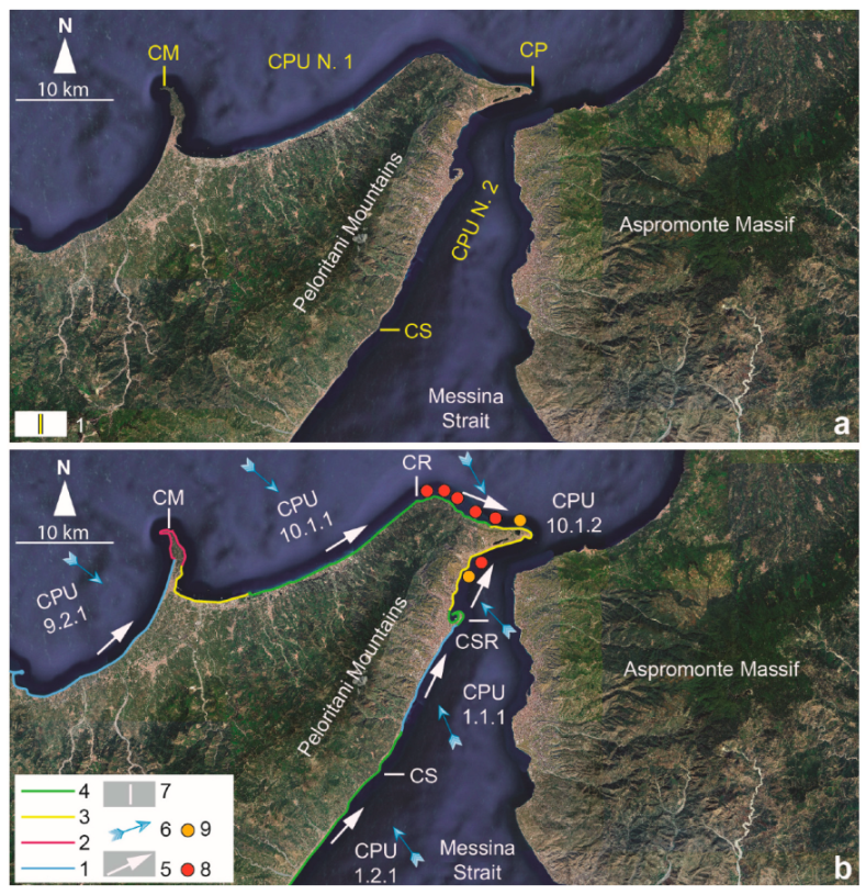
2. Study Area
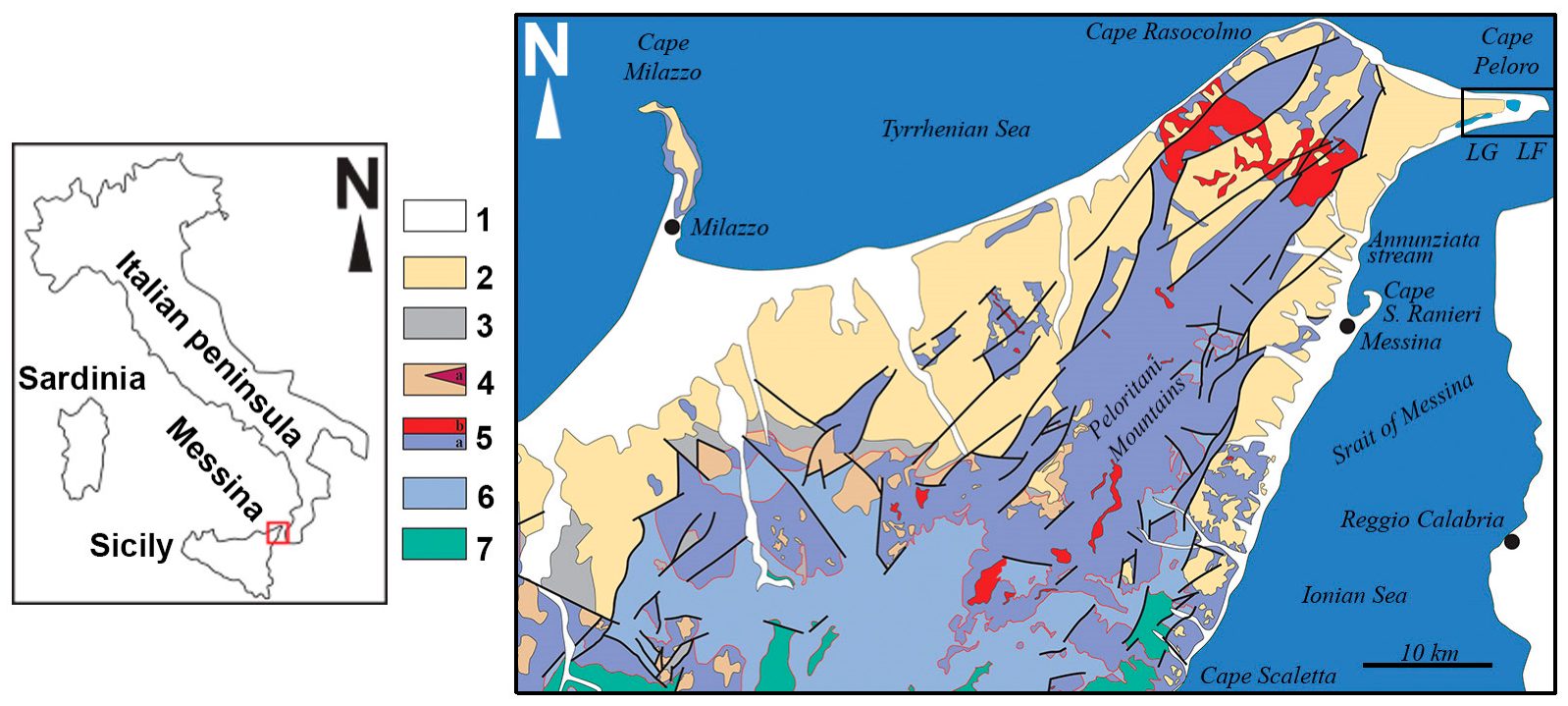
3. Geological Setting
- The Stilo–Capo d’Orlando Fm (middle–upper Burdigalian). The unit is composed of a syn- to late-tectonic terrigenous sequence made up of sandy, sandy–clayey, and sandy–conglomeratic turbidites, with olistoliths of metamorphic and sedimentary rocks. Clasts of the conglomerates were mostly composed of metamorphic rocks (gneiss, schists, phyllites) [37], quartz, and granitoids.
- The San Pier Niceto Fm (Tortonian to lower Messinian). The unit is formed by sandstones, siltstones, marly and sandy–clayey alternations, marls, clayey marls, and conglomerates. Clasts of the conglomerates were mostly composed of metamorphic rocks, often with platy shapes [38].
- The Messina Fm (lower to middle Pleistocene). The unit is made up of sands and gravels locally with moderately cemented layers. Clasts of the gravels were mostly composed of metamorphic rocks (gneiss, augen gneiss), quartz, granitoids, and pinkish or grayish porphyroids [38].
- The beachrocks (upper Holocene [39]). Clasts of the conglomerates were made up of crystalline rocks (granitoids and high-grade metamorphic rocks).
4. Wave Climate and Sediment Littoral Drift
5. Materials and Methods
5.1. Petrographic Analyses
5.2. Particle Size Analysis (PSA)
5.2.1. Mechanical Sieving
5.2.2. Laser Light Scattering
5.3. Shape and Roundness
6. Results
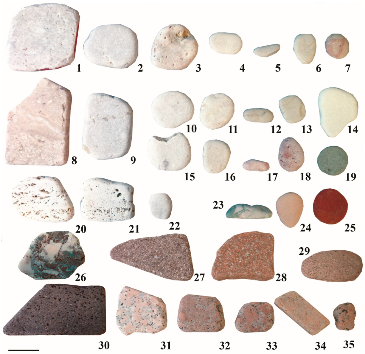
6.1. Samples
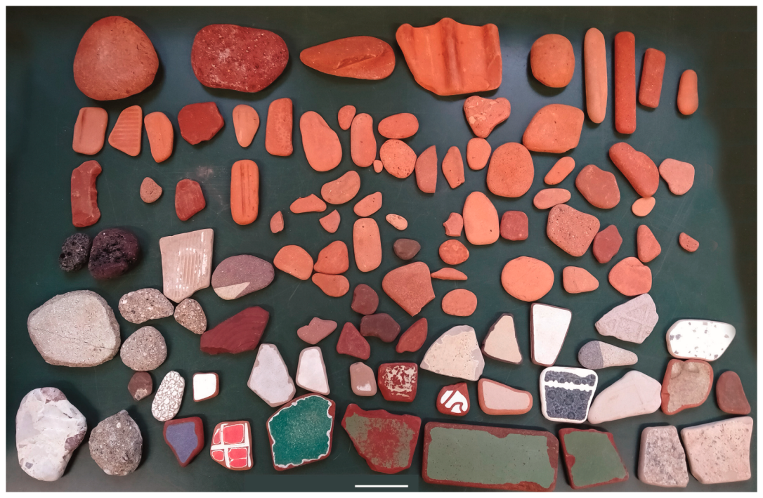
- Sample TB14, formed by representative fragments of natural pebbles of anthropogenic origin (NP), originally forming tiles and stoneware slabs.
- Sample TB15, made up of fragments of colored glass (G).
- Sample TB16, composed of representative fragments of bricks, tiles, and concrete (PT).
6.2. Petrographic Characterization
6.2.1. Beach Sands
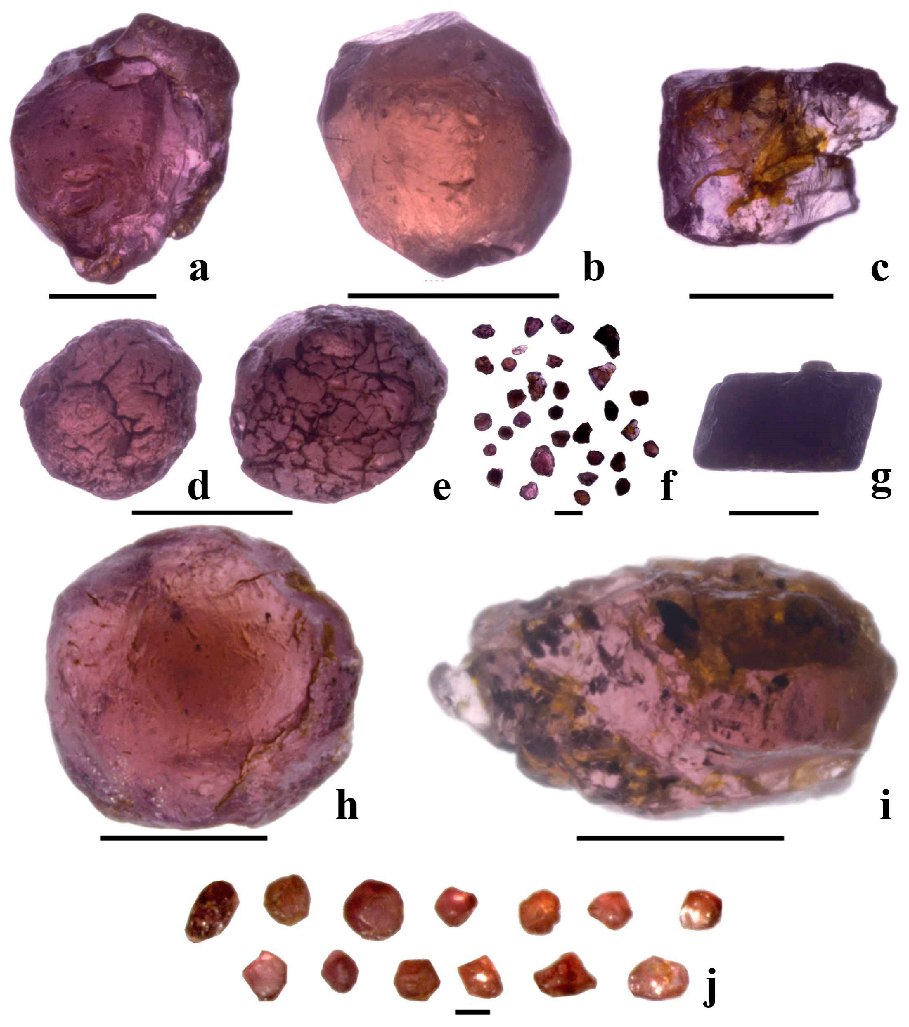
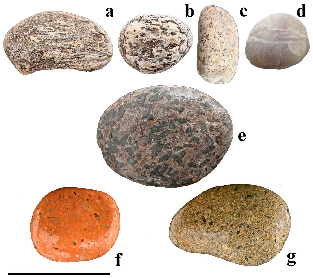
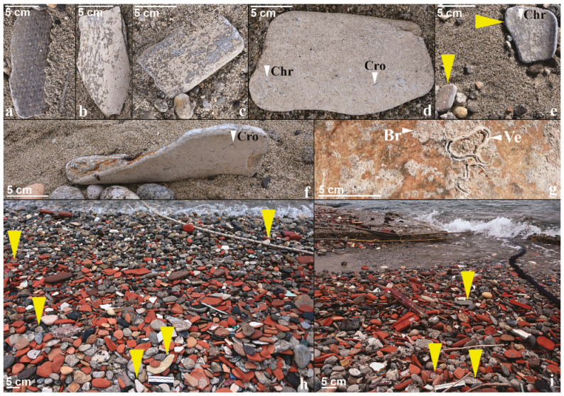
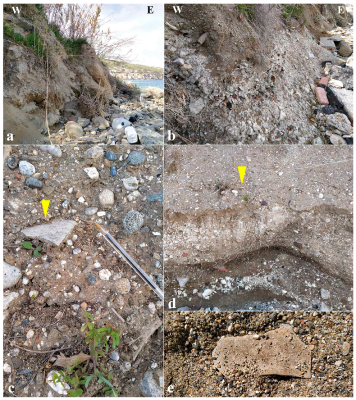
6.2.2. Pebbles and Cobbles
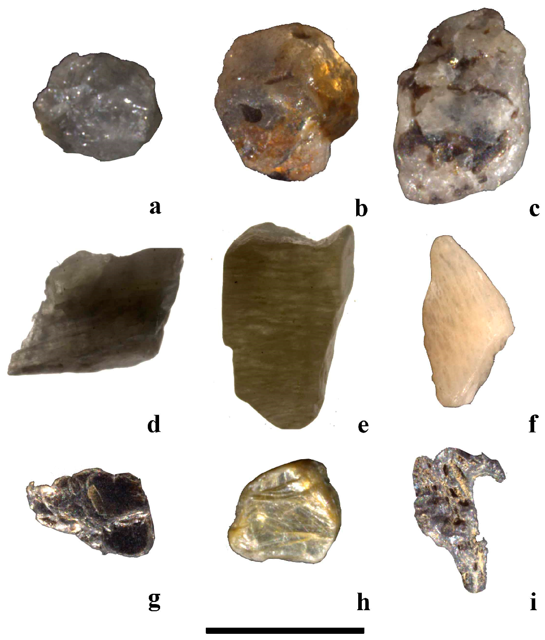
6.2.3. Technofossils
Construction Slabs
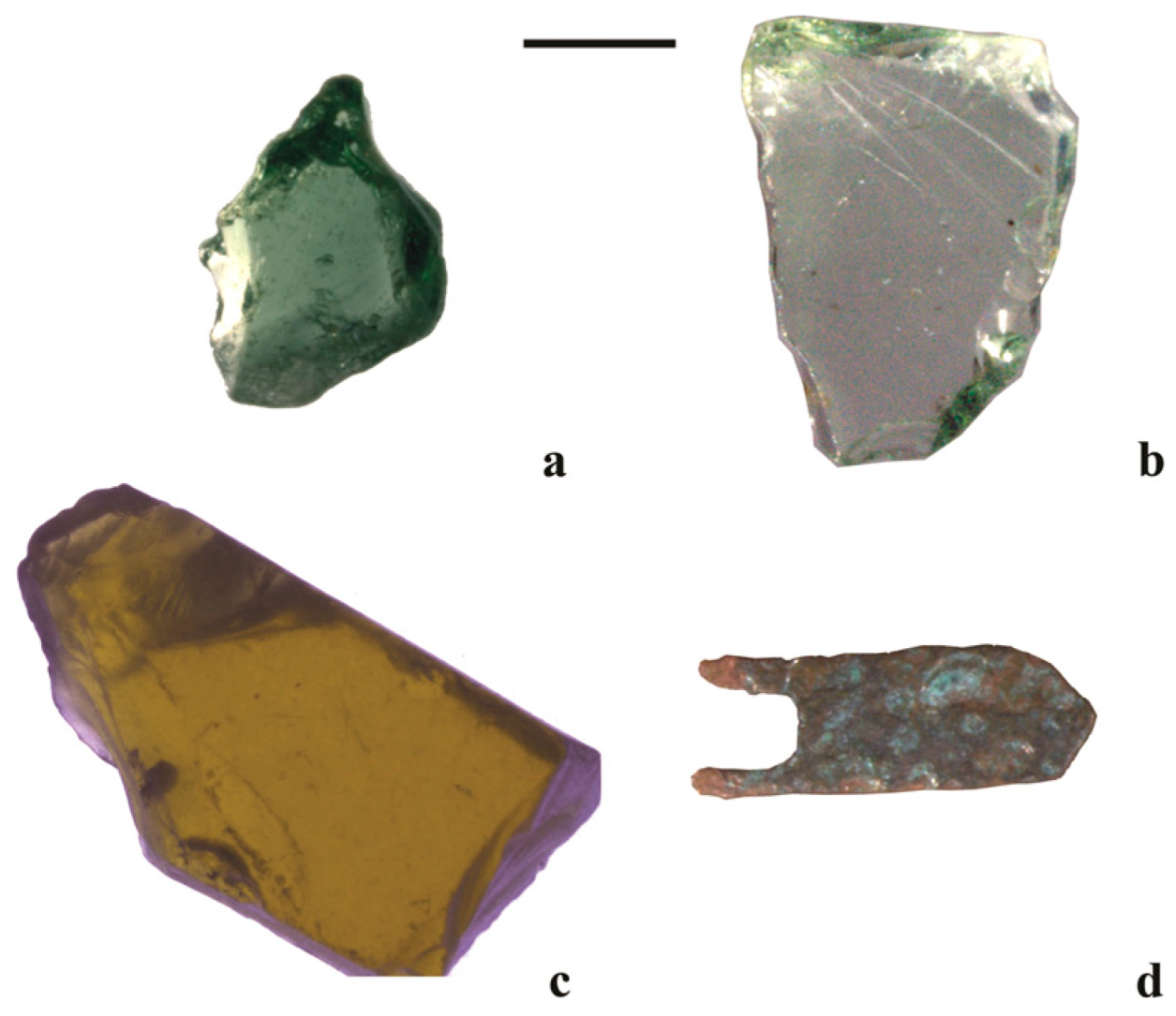
Anthropogenic Glass
Bricks, Tiles, Concrete
ACM
6.2.4. Messina Formation
- Biotite-bearing granitoids.
- Augen gneiss.
- Quartz and quartz with biotite.
- Gneiss and micaschist gneiss.
6.3. Textural Characterization
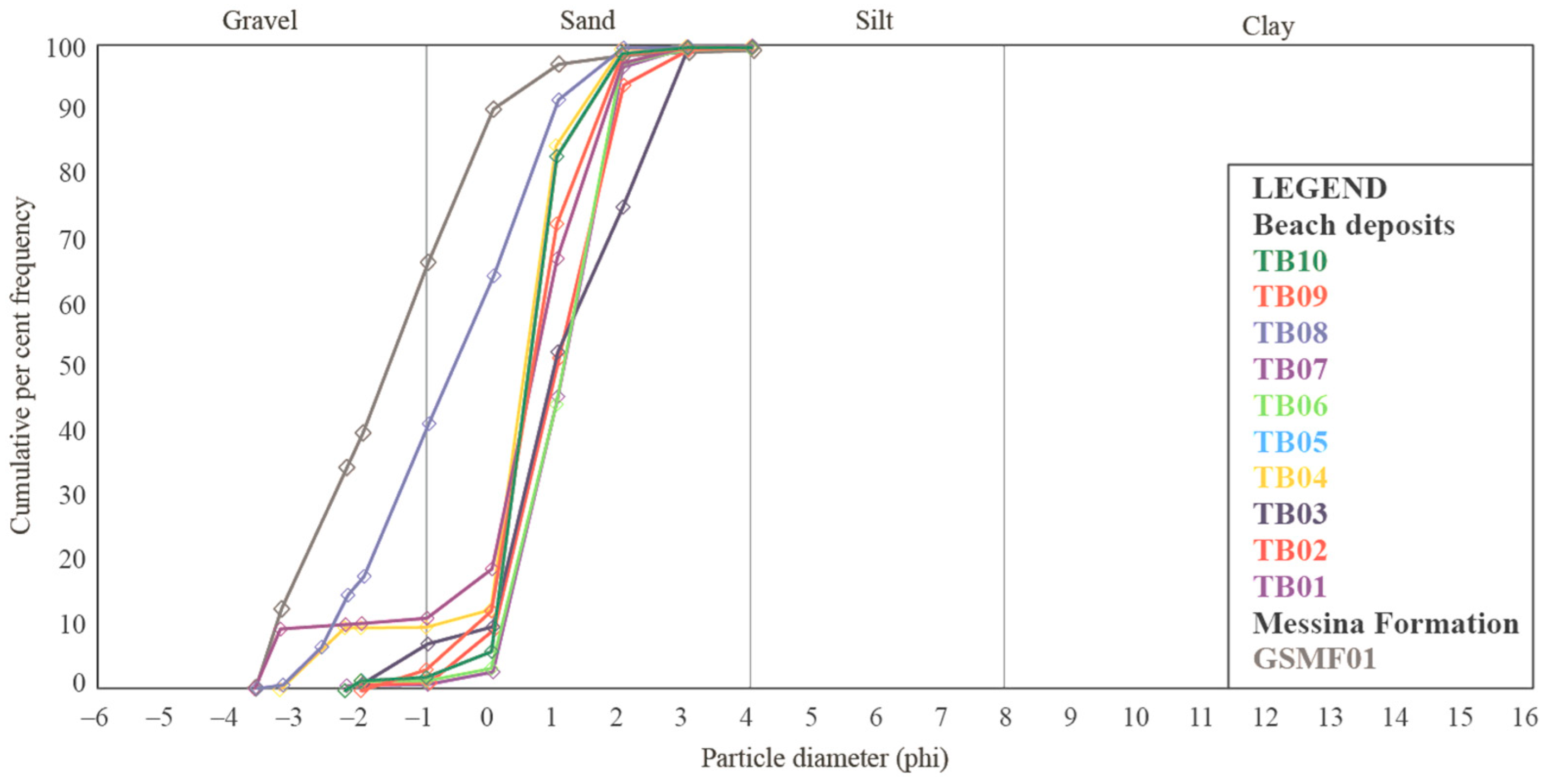
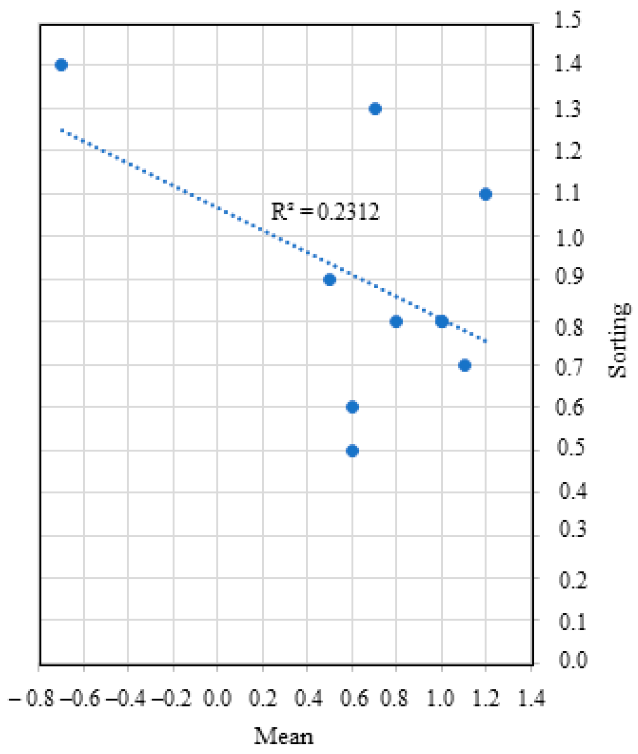
6.3.1. PSA Data Related to Mechanical Sieving
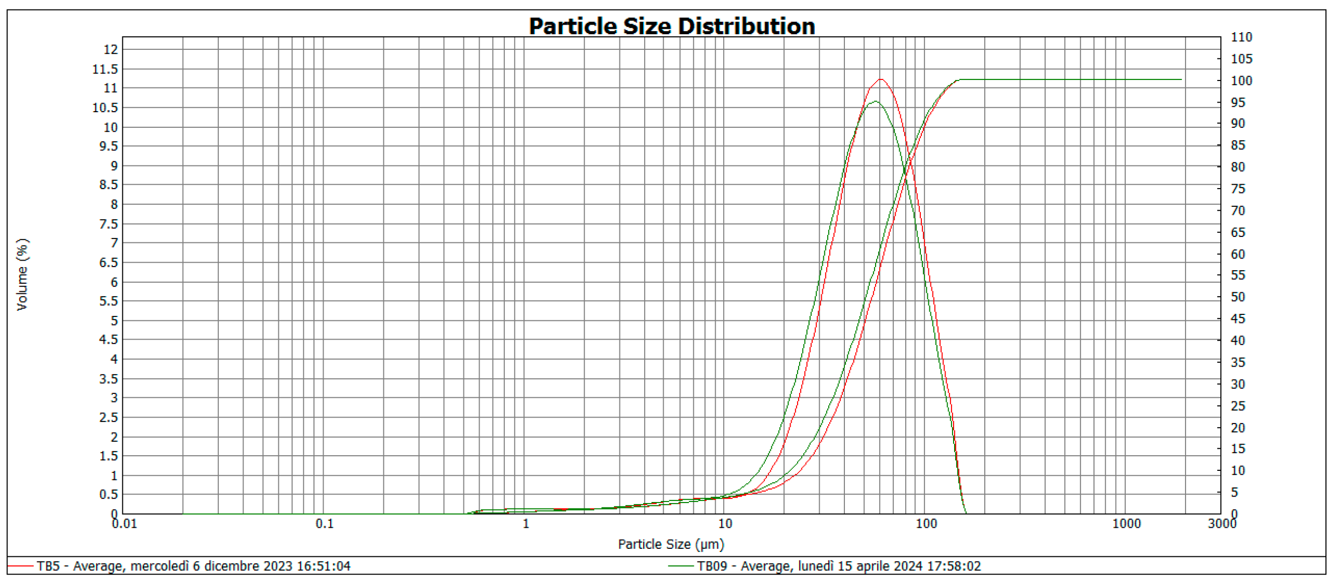
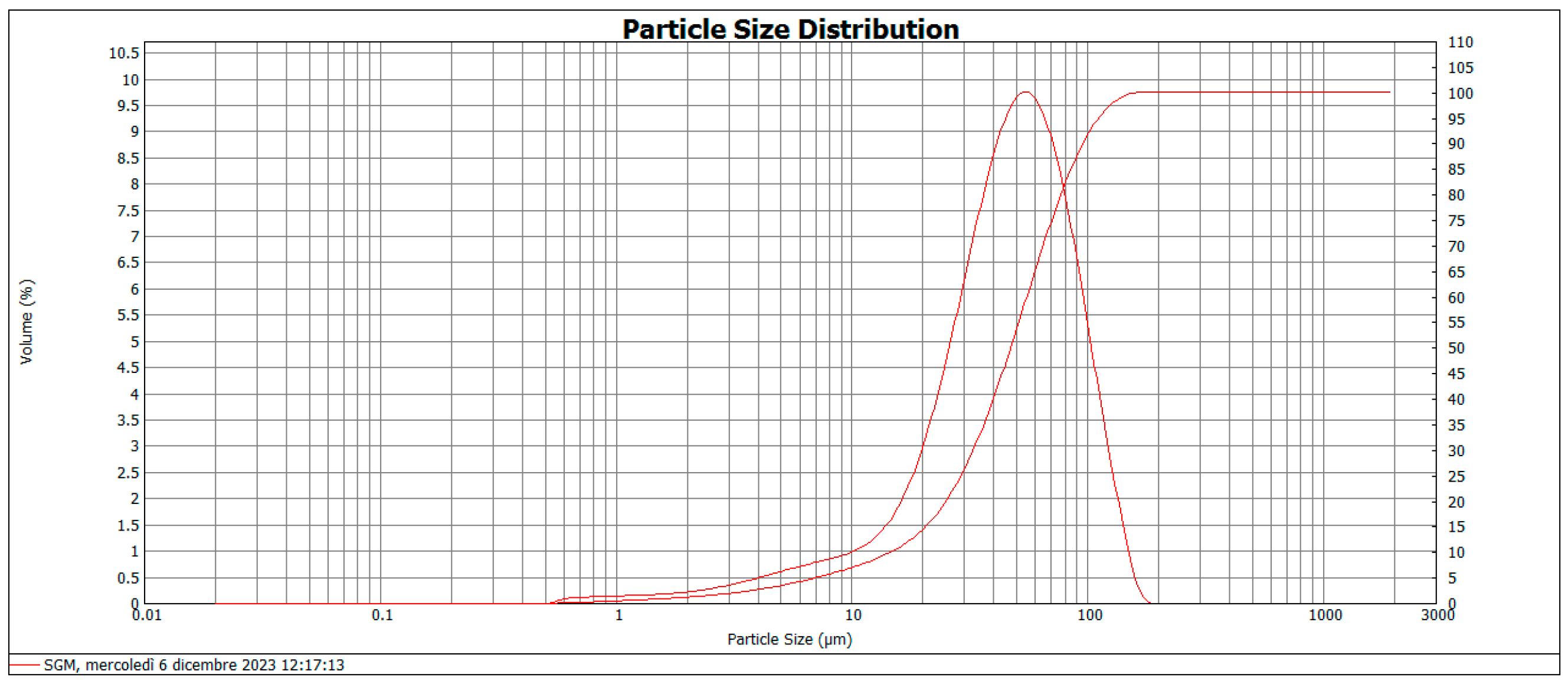
6.3.2. PSA Data Related to Laser Diffraction Method
6.3.3. Elongation (E)
6.3.4. Flatness (F)
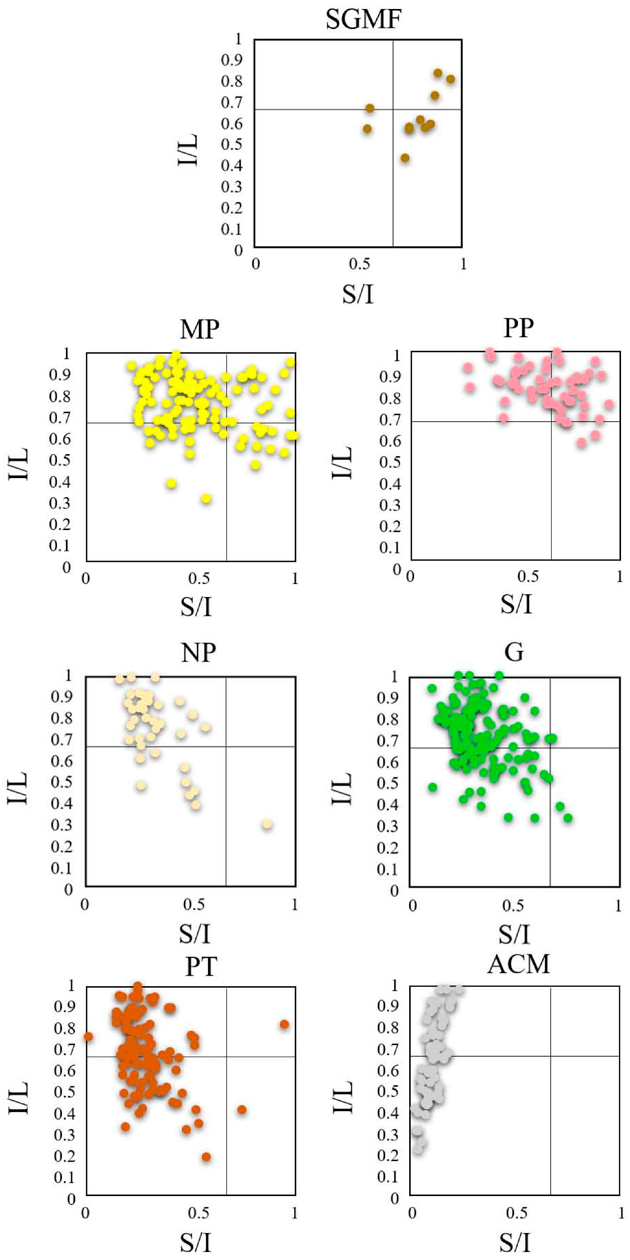
6.3.5. Zingg Diagram
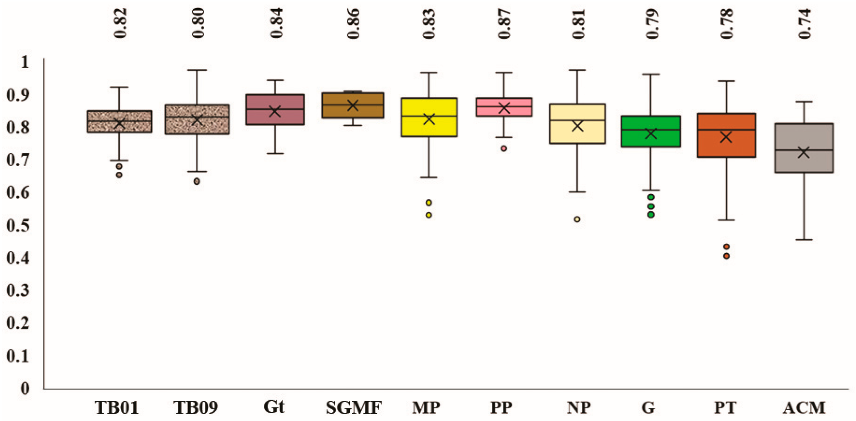
6.3.6. Riley Sphericity
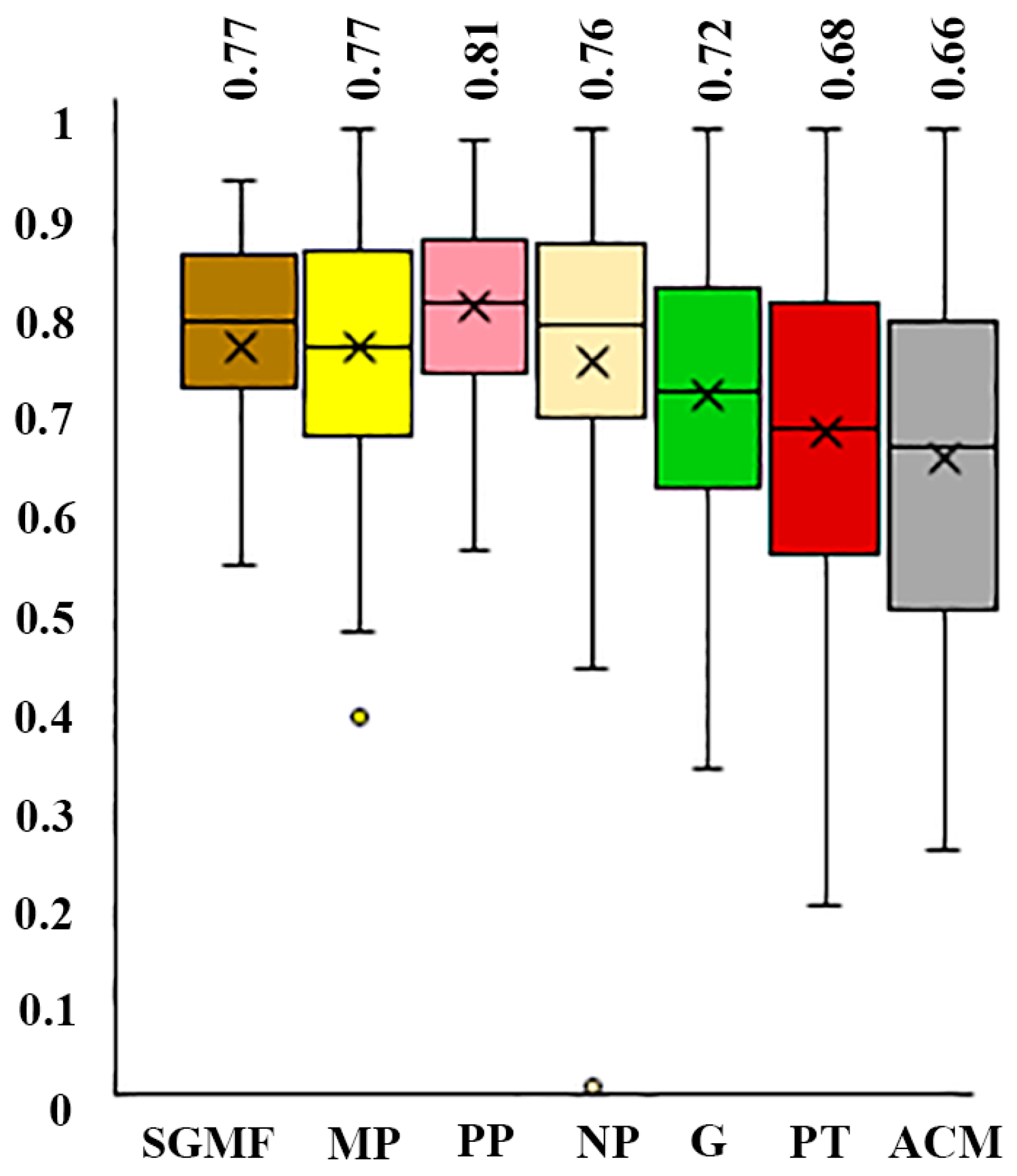
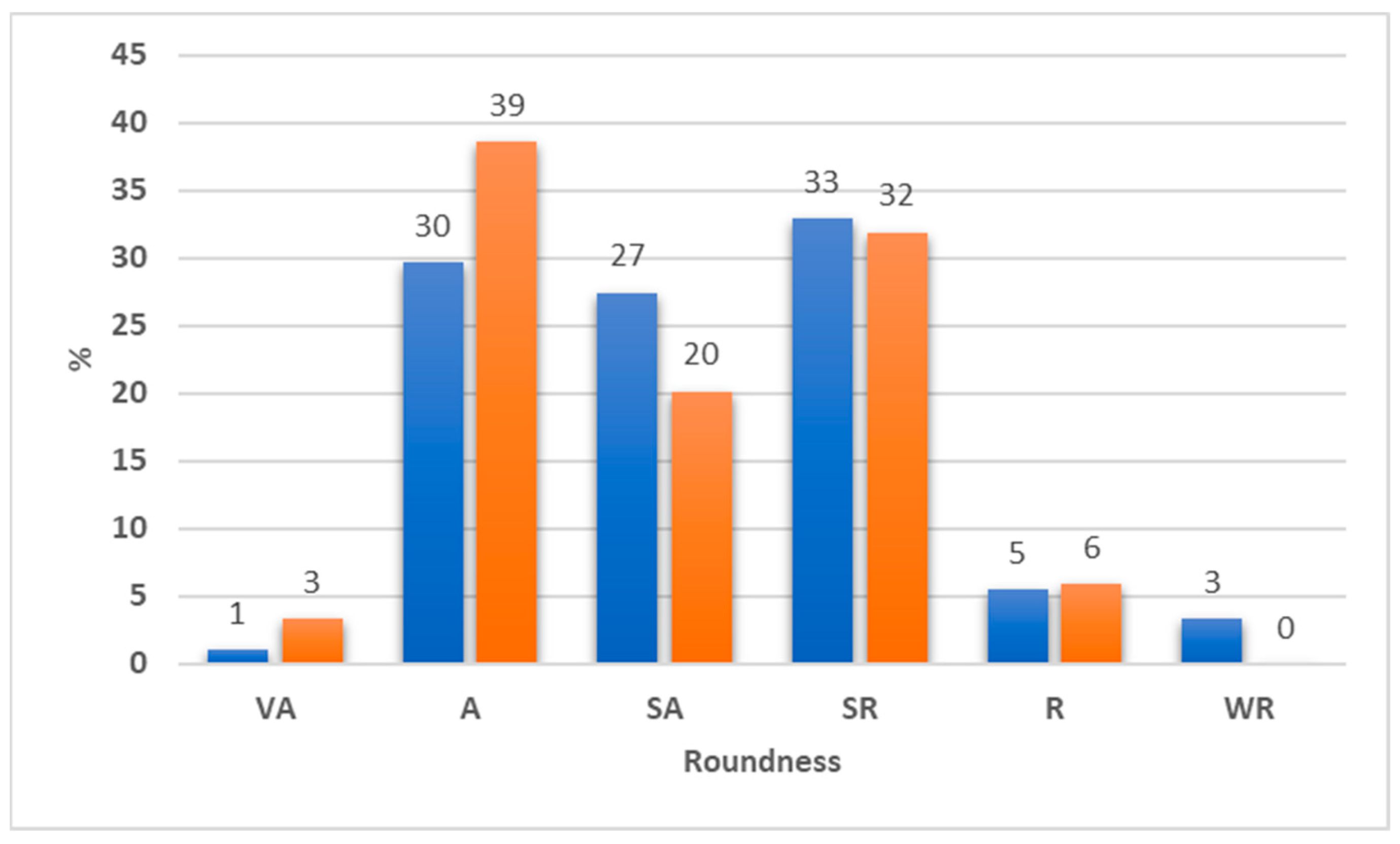
6.3.7. Roundness
7. Discussion
7.1. Petrographic Features
7.2. Textural Features
7.2.1. PSA Data
7.2.2. Shape Parameters
7.2.3. Average Roundness
7.3. Hazardous Human-Environmental Relationships
- Possible landfills widespread in the intensively urbanized coastal areas.
- Direct abandonment in the coastal area.
- Direct abandonment in the streams.
- Activities to counteract the erosion/lack of sediment affecting this sector of the coast.
8. Conclusions
- The extent of the contaminated beach deposits (in surface and depth).
- The source of the contaminant sources.
- The main mechanisms responsible for the contaminant dispersion.
Funding
Acknowledgments
Conflicts of Interest
References
- Legambiente. Available online: https://www.legambiente.it/rapporti-e-osservatori/liberi-dallamianto/ (accessed on 2 February 2024).
- Osservatorio Nazionale Amianto. Available online: https://onanotiziarioamianto.it/amianto-spiagge-necessario-effettuare-bonifica/ (accessed on 2 February 2024).
- Il Secolo XIX. Available online: https://www.ilsecoloxix.it/imperia/2013/05/09/news/amianto-emergenza-in-spiaggia-1.32312548 (accessed on 2 February 2024).
- Gruppo d’Intervento Giuridico. Associazione Ecologista. Available online: https://gruppodinterventogiuridicoweb.com/2022/05/15/cagliari-bonificata-dai-detriti-di-amianto-la-spiaggia-del-poetto/ (accessed on 20 December 2023).
- La Nuova di Venezia e Mestre. Available online: https://nuovavenezia.gelocal.it/venezia/cronaca/2010/01/21/news/venezia-quintali-di-eternit-nella-cittadella-del-cinema-1.1337278 (accessed on 3 December 2023).
- GalluraOggi.it. Available online: https://www.galluraoggi.it/cronaca/eternit-marina-maria-bonifiche-spiaggia-2-aprile-2023/ (accessed on 30 December 2023).
- LinkOristano. Available online: https://www.linkoristano.it/2020/06/11/bene-la-pulizia-della-spiaggia-ad-abarossa-ce-ancora-amianto/ (accessed on 30 December 2023).
- RomaToday. Available online: https://www.romatoday.it/cronaca/amianto-via-del-pesce-luna-fiumicino.html (accessed on 30 December 2023).
- FondiNotizie.net. Available online: https://www.fondinotizie.net/notizie/territorio/52/una-spiaggia-fatta-di-amianto#google_vignette (accessed on 30 December 2023).
- La Nazione. Available online: https://www.lanazione.it/viareggio/cronaca/eternit-spiaggia-libera-c9217e92 (accessed on 27 December 2023).
- Il Tirreno. Available online: https://www.iltirreno.it/piombino/cronaca/2018/04/23/news/eternit-sulla-spiaggia-della-sterpaia-1.16748868 (accessed on 28 December 2023).
- LaRegione. Available online: https://www.laregione.ch/estero/estero/1602113/lastre-eternit-lucca-viareggio-ambiente (accessed on 15 December 2023).
- QuiCosenza. Available online: https://www.quicosenza.it/news/provincia/42898-ancora-amianto-sul-litorale-di-san-lucido-spiagge-sotto-sequestro (accessed on 5 December 2023).
- BrindisiReport. Available online: https://www.brindisireport.it/cronaca/frammenti-di-Eternit-abbandonati-da-anni-su-spiaggia-di-Specchiolla.html (accessed on 15 December 2023).
- OsservatorioOggi. Available online: http://www.osservatoriooggi.it/notizie/attualita/5694-amianto-torre-cane-spiaggia-bambini-turisti-fasano (accessed on 15 February 2024).
- Ilnuovoamico. Available online: https://www.ilnuovoamico.it/2018/07/amianto-pericolo-a-ridosso-della-spiaggia-di-pesaro/ (accessed on 15 February 2024).
- Livesicilia. Available online: https://livesicilia.it/amianto-seppellito-sotto-la-sabbia-bonifica-alla-spiaggia-numero-3/ (accessed on 15 February 2024).
- Normanno. Available online: https://normanno.com/attualita/lastre-amianto-due-passi-dal-mare-biancuzzo-vanno-rimosse-subito/ (accessed on 15 February 2024).
- Tempostretto. Available online: https://www.tempostretto.it/news/inquinamento-sabbia-eternit-tanto-mare-sant-agata-mortelle.html (accessed on 15 February 2024).
- Messinatoday. Available online: https://www.messinatoday.it/cronaca/indagini-spiaggia-mili-marina-rifiuti-amianto-.html (accessed on 15 February 2024).
- La Repubblica. Available online: https://www.repubblica.it/green-and-blue/2010/05/03/news/spiagge_d_amianto_sui_fiumi_italiani_il_wwf_il_po_usato_come_discarica_-267371981/ (accessed on 22 February 2024).
- WWF Italia. Available online: https://www.wwf.it/pandanews/ambiente/amianto-nella-campagne-blitz-delle-guardie-wwf/ (accessed on 5 April 2024).
- Lisco, S.; Lapietra, I.; Laviano, R.; Mastronuzzi, G.; Fracchiolla, T.; Moretti, M. Sedimentological features of asbestos cement fragments in coastal environments (Taranto, southern Italy). Mar. Pollut. Bull. 2023, 187, 114469. [Google Scholar] [CrossRef]
- Somma, R.; Giacobbe, S.; La Monica, F.P.; Molino, M.L.; Morabito, M.; Spoto, S.E.; Zaccaro, S.; Zaffino, G. Defense and protection of the marine coastal areas and human health: A case study of asbestos cement contamination (Italy). Geosciences 2024, 14, 98. [Google Scholar] [CrossRef]
- Ispra Ambiente. Available online: https://www.isprambiente.gov.it/files/pubblicazioni/statoambiente/tematiche2011/05_%20Mare_e_ambiente_costiero_2011.pdf (accessed on 22 February 2024).
- Zalasiewicz, J.; Williams, M.; Waters, C.N.; Barnosky, A.D.; Haff, P. The technofossil record of humans. Anthr. Rev. 2014, 1, 34–43. [Google Scholar] [CrossRef]
- Messina, A.; Somma, R.; Macaione, E.; Carbone, G.; Careri, G. Peloritani continental crust composition (southern Italy): Geological and petrochemical evidence. Boll. Soc. Geol. Ital. 2004, 123, 405–441. [Google Scholar]
- Regione Sicilia. Available online: https://www.regione.sicilia.it/sites/default/files/2024-01/Format%20ITA030042-%20Monti%20Peloritani%2C%20Dorsale%20Curcuraci%2C%20Antennamare%20e%20area%20marina%20dello%20stretto%20di%20Messina.pdf (accessed on 2 January 2024).
- Regione Sicilia. Available online: https://www.regione.sicilia.it/sites/default/files/2024-01/Format%20ITA030008%20-%20Capo%20Peloro%20-%20Laghi%20di%20Ganzirri.pdf (accessed on 15 February 2024).
- National Geographic. Available online: https://www.nationalgeographic.co.uk/travel/2022/08/12-of-the-best-beaches-in-italy (accessed on 2 January 2024).
- Bonardi, G.; Giunta, G.; Liguori, V.; Perrone, V.; Russo, M.; Zuppetta, A. Schema geologico dei Monti Peloritani. Boll. Soc. Geol. It. 1976, 95, 49–74. [Google Scholar]
- Bonardi, G.; Caggianelli, A.; Critelli, S.; Messina, A.; Perrone, V.; Acquafredda, P.; Carbone, G.; Careri, G.; Cirrincione, R.; Derrico, M.; et al. Geotraverse across the Calabria-Peloritani Terrane (Southern Italy). In Proceedings of the 32nd International Geological Congress IUGS, Florence, Italy, 20–28 August 2004; Servizio Geologico d’Italia—APAT: Rome, Italy, 2004; pp. 1–60. [Google Scholar]
- Atzori, P.; Cirrincione, R.; Del Moro, A.; Pezzino, A. Structural, metamorphic and geochronologic features of the Alpine event in south-eastern sector of the Peloritani Mountains (Sicily). Period. Mineral. 1994, 63, 113–125. [Google Scholar]
- Cirrincione, R.; Pezzino, A. Caratteri strutturali dell’evento alpino nella serie mesozoica di Alì e nell’unità metamorfica di Mandanici (Peloritani orientali). Mem. Soc. Geol. Ital. 1991, 47, 263–272. [Google Scholar]
- Bonardi, G.; Compagnoni, R.; Del Moro, A.; Macaione, E.; Messina, A.; Perrone, V. Rb–Sr age constraints on the Alpine metamorphic overprint in the Aspromonte nappe (Calabria–Peloritani composite terrane, southern Italy). Boll. Della Soc. Geol. Ital. 2008, 127, 173–190. [Google Scholar]
- Somma, R.; Martin Rojas, I.; Perrone, V. The stratigraphic record of the Alì-Montagnareale Unit (Peloritani Mountains, NE Sicily). Rend. Online Soc. Geol. Ital. 2013, 25, 106–115. [Google Scholar]
- Guerrera, F.; Wezel, F.C. Nuovi dati stratigrafici sui flysch oligomiocenici siciliani e considerazioni tettoniche relative. Riv. Mineraria Sicil. 1974, 147, 27–51. [Google Scholar]
- Carbone, S.; Messina, A.; Lentini, F.; Barbano, M.S.; Grasso, D.; Di Stefano, A.; Ferrara, V.; Somma, R. Note Illustrative della Carta Geologica D’italia alla Scala 1: 50.000: Foglio 601; Dipartimento Difesa del Suolo, Servizio Geologico d’Italia: Firenze, Italy, 2008; pp. 1–170. [Google Scholar]
- Segre, A.G.; Bagnala, R.; Sylos Labini, S. Holocene evolution of the Pelorus headland, Sicily. Quat. Nova 2004, 8, 69–78. [Google Scholar]
- Catalano, S.; Cirrincione, R.; Mazzoleni, P.; Pavano, F.; Pezzino, A.; Romagnoli, G.; Tortorici, G. The effects of a Meso-Alpine collision event on the tectono-metamorphic evolution of the Peloritani mountain belt (eastern Sicily, southern Italy). Geol. Mag. 2018, 155, 422–437. [Google Scholar] [CrossRef]
- Guarnieri, P.; Pirrotta, C. The response of drainage basins to the late Quaternary tectonics in the Sicilian side of the Messina Strait (NE Sicily). Geomorphology 2008, 95, 260–273. [Google Scholar] [CrossRef]
- Ministero delle Infrastrutture e della Mobilità Sostenibili. Available online: https://www.google.com/search?q=relazione+geologica+ponte+sullo+stretto&rlz=1C1FHFK_itIT958IT958&oq=relazione+geologica+ponte+sullo+stretto&gs_lcrp=EgZjaHJvbWUyBggAEEUYOdIBCjEzNDkwajBqMTWoAgCwAgA&sourceid=chrome&ie=UTF-8 (accessed on 26 February 2024).
- Antonioli, F.; Ferranti, L.; Lambeck, K.; Kershaw, S.; Verrubbi, V.; Dai Pra, G. Late Pleistocene to Holocene record of changing uplift rates in southern Calabria and northeastern Sicily (southern Italy, Central Mediterranean Sea). Tectonophysics 2006, 422, 23–40. [Google Scholar] [CrossRef]
- Danjo, T.; Kawasaki, S. Characteristics of beachrocks: A review. Geotech. Geol. Eng. 2014, 32, 215–246. [Google Scholar] [CrossRef]
- Regione Siciliana. Available online: https://www.sitr.regione.sicilia.it/pai-coste-sicilia-e-aggiornamento-dati-pai/ (accessed on 27 February 2024).
- Regione Siciliana. Available online: https://www.regione.sicilia.it/sites/default/files/2021-09/01%20-%20D.A.%20319%20del%205%20agosto%202016%20%28ARTA%29%20-%20Utilizzo%20Aree%20demani.pdf (accessed on 27 February 2024).
- Regione Siciliana. Available online: https://www2.regione.sicilia.it/presidenza/ucomrifiuti/acque/DOCUMENTI/DOCUMENTI_D/D2/Acque_costiere.pdf (accessed on 27 February 2024).
- Regione Sicilia. Available online: https://www2.regione.sicilia.it/deliberegiunta/file/giunta/allegati/N.290_16.07.2020.pdf (accessed on 27 February 2024).
- Randazzo, G.; Cigala, C.; Crupi, A.; Lanza, S. The natural causes of shoreline evolution of Capo Peloro, the northernmost point of Sicily (Italy). J. Coast. Res. 2014, 70, 199–204. [Google Scholar] [CrossRef]
- Folk, R.L.; Ward, W.C. Brazos River Bar—A study in the significance of grain size parameters. J. Sediment. Petrol. 1957, 27, 3–26. [Google Scholar] [CrossRef]
- Blott, S.J.; Croft, D.J.; Pye, K.; Saye, S.E.; Wilson, H.E. Particle size analysis by laser diffraction. Geol. Soc. Spec. Publ. 2004, 232, 63–73. [Google Scholar] [CrossRef]
- Eshel, G.; Levy, G.J.; Mingelgrin, U.; Singer, M.J. Critical Evaluation of the Use of Laser Diffraction for Particle-Size Distribution Analysis. Soil Sci. Soc. Am. J. 2004, 68, 736–743. [Google Scholar] [CrossRef]
- Lucchi, F.R.; Mutti, E. Sedimentologia; Parte I, II, III; Clueb: Bologna, Italy, 1980. [Google Scholar]
- Perri, F.; Dominici, R.; Le Pera, E.; Chiocci, F.L.; Martorelli, E. Holocene sediments of the Messina Strait (southern Italy): Relationships between source area and depositional basin. Mar. Pet. Geol. 2016, 77, 553–566. [Google Scholar] [CrossRef]
- Sánchez-Navas, A.; Macaione, E.; De Cassia Oliveira-Barbosa, R.; Messina, A.; Martín-Algarra, A. Transformation of kyanite to andalusite in the Benamocarra Unit (Betic Cordillera, S. Spain). Kinetics and petrological significance. Eur. J. Mineral. 2016, 28, 337–353. [Google Scholar] [CrossRef]
- Gazzetta del Sud. Available online: https://rtp.gazzettadelsud.it/programmi/telegiornale/2024/05/11/lo-stop-ai-lavori-del-parcheggio-paradiso-di-messina-la-sabbia-con-plastica-era-certificata-come-idonea-454d238c-204c-4b03-8f8f-860b302faf6a/ (accessed on 11 May 2024).
- Copernicus. Available online: https://marine.copernicus.eu/ (accessed on 27 February 2024).
- Gazzetta del Sud. Available online: https://rtp.gazzettadelsud.it/programmi/telegiornale/2024/04/22/messina-fuochi-dartificio-illegali-a-mezzanotte-un-malcostume-da-perseguire-7279ea12-aa01-40be-a2a5-01cfed6a745b/#:~:text=Una%20clamorosa%20bufala%20che%20non,o%20altre%20ricorrenze%20del%20genere (accessed on 24 April 2024).
- Gruppo d’Intervento Giuridico. Available online: https://gruppodinterventogiuridicoweb.com/2022/04/07/nuovamente-amianto-sulla-spiaggia-del-poetto-cagliari/ (accessed on 30 April 2024).
- VII Rapporto del Registro Nazionale dei Mesoteliomi (ReNaM), Italia. 2021. Available online: https://www.inail.it/cs/internet/comunicazione/pubblicazioni/catalogo-generale/pubbl-il-registro-nazionale-mesoteliomi-settimo-rapporto.html (accessed on 30 April 2024).


| Parameter | TB01 | TB02 | TB03 | TB04 | TB5 | TB06 | TB07 | TB08 | TB09 | TB10 |
|---|---|---|---|---|---|---|---|---|---|---|
| Mean | 1.0 | 1.0 | 1.2 | 0.5 | 0.6 | 1.1 | 0.7 | −0.7 | 0.8 | 0.6 |
| Median | 1.0 | 1.0 | 1.0 | 0.5 | 0.6 | 1.1 | 0.7 | −0.6 | 0.6 | 0.6 |
| Sorting | 0.8 | 0.8 | 1.1 | 0.9 | 0.6 | 0.7 | 1.3 | 1.4 | 0.8 | 0.5 |
| Skewness | −0.1 | −0.1 | 0.2 | −0.3 | −0.1 | −0.1 | −0.3 | −0.1 | 0.1 | 0.0 |
| Kurtosis | 0.9 | 0.8 | 0.8 | 2.8 | 1.9 | 0.7 | 1.9 | 0.8 | 1.3 | 1.3 |
| Parameter | TB05 | TB09 | SGMF01 |
|---|---|---|---|
| Mean | 4.3 | 4.3 | 4.5 |
| Median | 4.2 | 4.3 | 4.4 |
| Sorting | 0.8 | 0.9 | 1.1 |
| Skewness | 0.2 | 0.2 | 0.3 |
| Kurtosis | 1.1 | 1.1 | 1.3 |
Disclaimer/Publisher’s Note: The statements, opinions and data contained in all publications are solely those of the individual author(s) and contributor(s) and not of MDPI and/or the editor(s). MDPI and/or the editor(s) disclaim responsibility for any injury to people or property resulting from any ideas, methods, instructions or products referred to in the content. |
© 2024 by the author. Licensee MDPI, Basel, Switzerland. This article is an open access article distributed under the terms and conditions of the Creative Commons Attribution (CC BY) license (https://creativecommons.org/licenses/by/4.0/).
Share and Cite
Somma, R. Petrographic and Textural Characterization of Beach Sands Contaminated by Asbestos Cement Materials (Cape Peloro, Messina, Italy): Hazardous Human-Environmental Relationships. Geosciences 2024, 14, 167. https://doi.org/10.3390/geosciences14060167
Somma R. Petrographic and Textural Characterization of Beach Sands Contaminated by Asbestos Cement Materials (Cape Peloro, Messina, Italy): Hazardous Human-Environmental Relationships. Geosciences. 2024; 14(6):167. https://doi.org/10.3390/geosciences14060167
Chicago/Turabian StyleSomma, Roberta. 2024. "Petrographic and Textural Characterization of Beach Sands Contaminated by Asbestos Cement Materials (Cape Peloro, Messina, Italy): Hazardous Human-Environmental Relationships" Geosciences 14, no. 6: 167. https://doi.org/10.3390/geosciences14060167
APA StyleSomma, R. (2024). Petrographic and Textural Characterization of Beach Sands Contaminated by Asbestos Cement Materials (Cape Peloro, Messina, Italy): Hazardous Human-Environmental Relationships. Geosciences, 14(6), 167. https://doi.org/10.3390/geosciences14060167