Article

Cenozoic Reactivation of the Penacova-Régua-Verin and Manteigas-Vilariça-Bragança Fault Systems (Iberian Peninsula): Implication in Their Seismogenic Potential

by
Sandra González-Muñoz
* and
Fidel Martín-González
Área de Geología—ESCET, TECVOLRISK Research Group, Universidad Rey Juan Carlos, C/Tulipán s/n, Móstoles, 28933 Madrid, Spain
*
Author to whom correspondence should be addressed.
Geosciences 2024, 14(9), 243; https://doi.org/10.3390/geosciences14090243
Submission received: 24 July 2024 / Revised: 4 September 2024 / Accepted: 7 September 2024 / Published: 10 September 2024
(This article belongs to the Section Structural Geology and Tectonics)

Abstract

:
The Penacova-Régua-Verin (PRV) and the Manteigas-Vilariça-Bragança (MVB) are two of the longest faults of the Iberian Peninsula. These faults striking NNE–SSW, over lengths of >200 km, were developed during late-Variscan Orogeny and reactivated in response to the Alpine Cycle tectonics. Their tectonic evolution during Alpine compression (Cenozoic) and their implication in the active tectonic activity of Iberia are under discussion. Their recent tectonic activity is recorded in the vertical offset of geomorphological surfaces, in the associated pull-apart basins, and in M > 7 paleoseismic events. Based on the vertical surface offset of Pliocene surfaces (140–300 m for the MVB fault and 150–200 m for the PRV), together with the horizontal offset (1300–1600 m for MVBF fault and 600–1400 m for PRVF), we can conclude that they were reactivated as left-lateral strike-slip faults with a reverse component during the Pliocene (3.6 Ma)–present. These results indicate that these faults are not related to the strain transmission during the collision with Eurasia (Eocene–Oligocene). However, they are related to the intraplate strain of the southern collision with the African plate during the Upper Neogene. The estimated slip-rate is 0.2–0.5 mm/a for both faults. These slip-rates evidence important implications for the seismic hazard of this intraplate region.

1. Introduction

NW Iberia contains two of the longest faults systems of the Iberian Peninsula: the Penacova-Régua-Verin (PRV) and the Manteigas-Vilariça-Bragança (MVB) (Figure 1). These left-lateral strike-slip faults strike N30° over lengths of >200 km and are active nowadays [1,2]. They are considered faults generated during the late stages of the Variscan Orogeny [1,3,4].
These structures were reactivated in response to the Alpine Cycle compression, and their role in the Iberian Peninsula tectonics during the Cenozoic is an important discussion topic. Some authors propose that these faults played an essential role as a transfer zone between northern Iberia (Cantabrian Mountains; CM) and the interior of the western Iberian Peninsula (Portugues Central System; PCS) during the Eocene and Oligocene [5,6,7,8,9,10,11]. Other authors propose that the reactivation of these faults is the intraplate deformation associated with the Africa–Europe collision during the late Miocene [12,13,14].
The dating of syn-tectonic sediments linked to these faults poses a challenge, leading to debates about the timing of their activity. According to the estimation of the age of the syn-tectonic sediments, some authors propose that the reactivation of these faults began during the late Tortonian period (approximately 9–9.5 Ma [15,16,17]), but other authors propose the Lower Pliocene [18,19,20,21].
The PRV and MVB faults are active nowadays with relevant Quaternary activity (slip rates of 0.25–0.5 mm/a). They also have a high seismogenic potential, M > 7 [2,22,23,24,25,26]. These values are comparable to the most active faults located in Iberia’s southeast plate boundary, such as the Palomares or the Alhama de Murcia faults [22,27,28].
This research quantifies and analyzes the tectonic activity of the Penacova-Régua-Verin (PRV) and Manteigas-Vilariça-Bragança (MVB) intraplate fault systems during the Cenozoic compression. It further explores their consequential impact on the tectonic framework of the Iberian Peninsula and their implication in the seismic hazard of this intraplate region. In order to accomplish this, a structural mapping was conducted, supplemented by classical structural techniques. These techniques included the examination of geomorphological surfaces and an analysis of the associated pull-apart basin geometries.
Figure 1. Schematic geological map of the Iberian Massif and the location of the study area. Modified from [12,29].
Geosciences 14 00243 g001

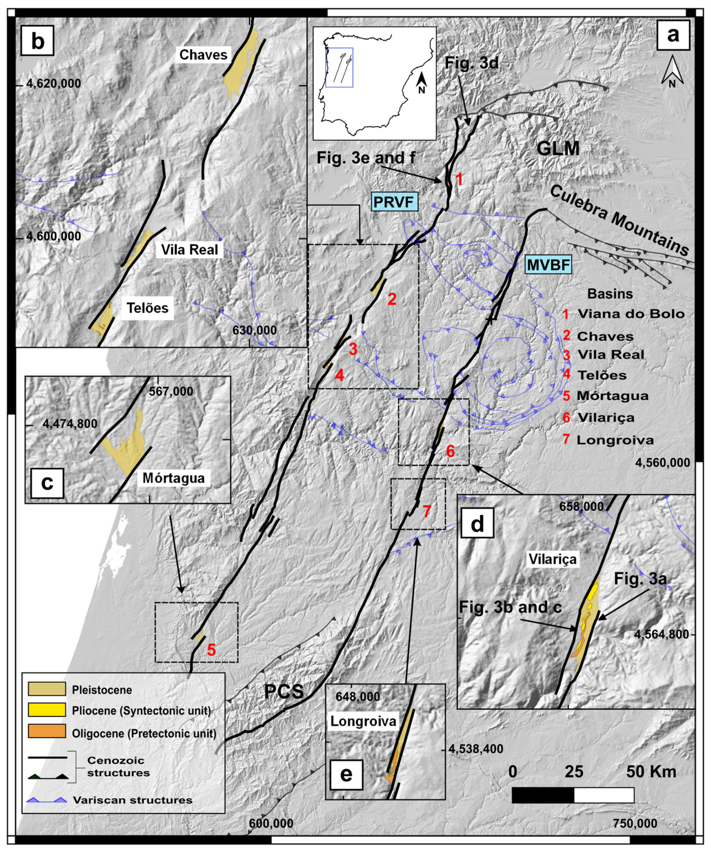
2. Geological Context

The structural and geological settings of the NW of the Iberian Peninsula are the result of the Variscan and Alpine Orogenies (Figure 1). After the Variscan Orogeny, the PRV and MVB fault systems played a remarkable role in the Cenozoic tectonics of the Iberian Peninsula. Some authors propose that the faults were reactivated during N–S Oligocene compression, transferring the deformation from the northern collision with the Eurasian plate (the Cantabrian Mountains; CM) inward of the Iberian Peninsula uplifting the Portuguese Central System (PCS) (Figure 2a). Therefore, these faults are the lateral structures of the thrust that uplifted the reliefs [5,6,7,8,9,10,11]. However, other authors indicate that the reactivation period of these fault systems is late Miocene. These authors interpret the reactivation as intraplate deformation related to the collision of the Iberian Peninsula with Africa, transferring deformation to the Galaico-Leoneses Mountains (GLM). This tectonic activity reactivates inherited late-Variscan fault systems (Figure 2b) [13,14].
The tectonic activity is recorded in the pull-apart basin sedimentation associated with these faults [17,19]. The sedimentary record of these basins can be classified into two types: (1): Pre-tectonic deposits: Arkosic type which belong to the Oligocene–Lower Miocene (e.g., the Vilariça Formation; Figure 3b) [17,30]; (2) Syn-tectonic deposits: Conglomeratic type from the Upper Miocene–Pliocene (e.g., Bragança Formation) (Figure 3c,e,f) [17,19].
Along with the sedimentary record (Figure 4), there are geomorphological surfaces displaced vertically in response to the Cenozoic activity. In the study area, three main geomorphological surfaces can be identified (Figure 5): (1) Quartzite Crests (also named “Initial Surface”), represents an older planation surface, Mesozoic in age and developed around ~300 m a.s.l. [20,31,32,33]; (2) Culmination Surface of the Mountain Ranges, which is late Cenozoic in age, and presents an elevation > 1000 m a.s.l. [18,21,33]; (3) The Fundamental Surface, which is the most continuous surface (Figure 3a), is Pliocene–Lower Pleistocene in age, and developed from 600–1000 m a.s.l. [1,21,33,34].
Studies on the current active tectonics of the MVB fault system have recorded a vertical displacement ranging from 150 to 200 m. This displacement has been determined through the analysis of geomorphological surfaces dating back to the Pliocene–Lower Pleistocene periods [1,2,23]. Moreover, 1000 m of horizontal displacement was measured in Lower Pleistocene terraces in the Douro River, obtaining a slip-rate of 0.2–0.5 mm/a in the Quaternary. Paleoseismic studies by [2,23] included trenching in the Vilariça basins and in the Meão valley. Ref. [2] identified 2–3 events of magnitude Mw > 7 in Pleistocene and Holocene alluvial sediments. The approximated displacement for the fluvial channel was 6.5 m after 18 Ka, and 9 m for 23 Ka, resulting in an activity rate of 0.3–0.5 mm/a for the Quaternary. Later, [23] identified alluvial sediments displaced in the Meão valley, with an age lower than 16 Ka, confirming the results obtained by [2]. In the case of the PRV fault, there are no specific paleoseismic studies, but in the database of active faults in the Iberian Peninsula, a net slip-rate of 0.275 mm/a is assigned [24].
Figure 3. (a) Panoramic view toward the south of the Vilariça pull-apart basin, showing the uplift of the western block across the fundamental surface. The number corresponds to the topographic profile in Figure 5. (b) Field picture of the pre-tectonic sediments (arkoses of Fm. Vilariça). (c) Field picture of the syn-tectonic sediments (conglomerates with blocks of quartzite and angular granites immersed in a sandy matrix, Fm. Bragança). (d) Field aspect of the fault breccia of the PRVF northern part. (e) Field picture of the Viana del Bollo basin and its syn-tectonic sediments, consisting mainly of sandy matrix conglomerates and quartzite cobbles. Note the 30° tilting, indicating the fault activity after its deposits. (f) Field picture of the syn-tectonic sediments in Viana do Bolo basin. Locations shown in Figure 4.
Geosciences 14 00243 g003
Figure 4. (a) Geological map of the traces and associated basins of the PRV and MVB faults. (b) Detailed map of the Chaves, Vila Real, and Telões basins. (c) Detailed map of the Mórtagua basin. (d) Detailed map of the Vilariça basin. (e) Detailed map of the Longroiva basin. (GLM) Galaico-Leoneses Mountains; (PCS) Portugal Central System.
Geosciences 14 00243 g004

3. Methodology

In this study, we have combined detailed structural mapping of the alpine structures and geomorphological surfaces, with classical techniques such as the area restoration method and the estimation of the fault displacement related to the geometries of the pull-apart basins.

3.1. Structural and Surface Mapping

The structural mapping was preceded by a review of the available geological maps, including the Spanish Geological Service maps (MAGNA, GEODE), the Portuguese Geological Survey maps (LNEG), and maps from other researchers [1,12,18,21,33,34,35]. Also, we reviewed the works on the description of geomorphologic surfaces in the area, such as [1,18,20,32,33,34]. In the structural mapping, special attention has been paid to the geometry of the pull-apart basins and the geometry of the faults to define their kinematics. The mapping of the basins, geomorphologic surfaces (Figure 4 and Figure 5), and topographic profiles (Figure 6) was conducted using DEM with a resolution of 2 m from the MDT02 (IGN, 2023) and DEM-v1.1-E20N20 [36].

3.2. Slip-Rate Estimation

The characterization of the net slip rates of the PRV and MVB faults was assessed with the horizontal displacement measured in the geometry of the pull-apart basins (Figure 4), together with the vertical displacement measured in the geomorphological surfaces (Figure 5). Once the values of the vertical and horizontal displacement were obtained, we estimated the net slip-rate considering the two possible ages proposed for the sedimentation of the basins: (1) Tortonian (9–9.5 Ma) [16,17,30]; (2) Lower Pliocene (3.6 Ma) [17,19].
The analysis of the vertical displacement of the geomorphological surfaces was made by longitudinal elevation profiles over DEM-v1.1-E20N20 [36], combined with the review of the pre-existing geomorphological maps [21,33,34].
The horizontal displacement was obtained from the empirical equations that relate the geometry of the basin to its displacement [37,38,39]. These empirical equations use the thickness of the basin in meters (T) to obtain the fault displacement expressed in meters (D) (Equation (1)) [38]. In those cases, where the basin thickness was unknown, we applied the equations from [37,39] (Equations (2) and (3)). They calculated the basin thickness for its relationship with the length (L; Equation (2)) and width, both measured in meters (W; Equation (3)) of the basin. The validation of the basin thickness estimation was made by comparing the results with the real data obtained from geophysical studies and boreholes in the Chaves basin [40,41]. A good correlation was observed, with errors of 6% and 20% for the results obtained in Equation (2) and Equation (3), respectively.
T = 0.36 D − 1.4
T = 0.8 L + 0.26
T = 0.1104 L − 0.08755 W E = A= Td * D

3.3. Excess Area Restoration

As the PRV and MVB fault systems are considered lateral structures that accommodate the shortening of the thrusts that uplifted the Alpine Cantabrian Mountains (CM) (Figure 2a) [5,9], or the Galaico-Leoneses Mountains (GLM) (Figure 2b) [13,14], we can estimate the displacement required to uplift the mountain ranges (Td) by using the classical technique of excess-area restoration [42,43,44,45] (Figure 7a).
The concept of excess area restoration (Figure 7a) establishes a correlation between the current mountainous area (E) and its original, pre-shortening area (A) (Equation (4)) [42,43,44,45]. The shortened area (A) is derived from the relationship between the thrust displacement (Td) and the depth of detachment (D). Considering the significant range in potential detachment depths, which spans from 15 to 30 km [12,46], we have calculated the displacement (Td) by considering 15, 20, 25, and 30 km as plausible detachment depths. The excess area in the deformed stage (E) is estimated from topographic profiles using digital elevation models from the MDT02-IGN2023 and DEM-v1.1-E20N20 [36] (Figure 7b,c). To calculate the uplift for each mountain range, we have made profiles on the reliefs of the Cantabrian Mountains (Figure 7b,c; profile A-A′) and Galaico-Leoneses Mountains (Figure 7b,c; profile B-B′). These profiles have been drawn normal to the main thrusts from [5,9,13] (Figure 2).
E = A = T d     D

4. Results

4.1. Fault Displacement
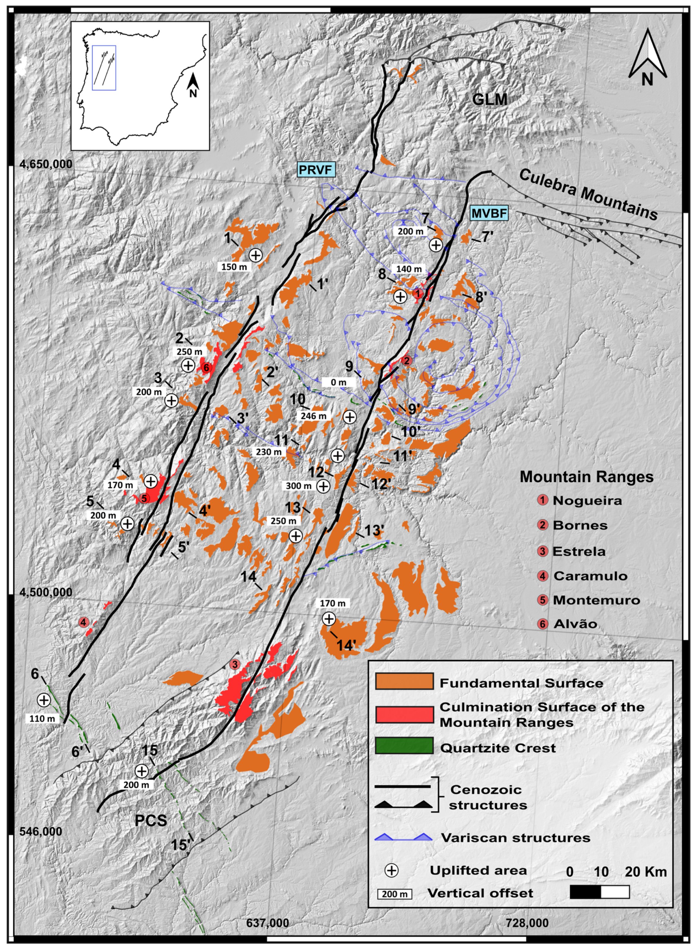
The horizontal displacement was estimated based on the geometry of the pull-apart basins [37,38]. Although the orientation of the two faults is N30°, dipping 80° toward the NW, the geometries of the basins are not similar. The mapping, shown in Figure 4, highlights the different geometries between the basins of the two faults. The MVB fault basins are narrower, with values of 1800 m and 860 m wide for the Vilariça and Longroiva basins (Figure 4; Table 1), respectively. In contrast, the PRV basins are wider, as in the case of the Chaves basin (3500 m wide) or the Vila Real basin (2600 m wide) (Figure 4; Table 1). The horizontal displacement calculated range is from 1300–1600 m for the MVB fault and from 600–1400 m for the Verin fault (Table 1).
The vertical displacement was measured from geomorphological surfaces. In the study area, 3 main surfaces have been identified in the literature [1,18,20,21,32,33,34] (Figure 5): (1) Quartzite Crest [18,31] has an average elevation of 400–500 m a.s.l. and shows 110 m of vertical offset in the PRV fault and 200 m in the MVB fault (Figure 5 and Figure 6; profiles 6-6′ and 15-15′). (2) Culmination Surface of the Mountain Ranges (Late Cenozoic) [33] is located at 1100–1200 m a.s.l. The vertical offset measured is 50–100 m for the two faults (Figure 5 and Figure 6). (3) Fundamental Surface (Pliocene–Lower Pleistocene) [1,21,33,34] is the most continuous surface (Figure 3a) with an average elevation of 500–1000 m a.s.l. (Figure 5 and Figure 6). The vertical offset for the Fundamental Surface has a range value of 150–250 m for the PRV fault, and 140–300 m for the MVB fault (Figure 5). The maximum displacement measured for both faults is located in their central sections (Figure 6 profile 2-2′ and 12-12′). In all the surfaces, the uplifted block is the western block, which evidences that the faults have a reverse component.
Figure 5. Main surfaces in the study area, with the vertical offset value measured and the localization of the profiles in Figure 6. Modified and improved from [21,33,34].
Geosciences 14 00243 g005
Figure 6. Profiles of surfaces through the PRV and MVB fault systems. The location of the profiles is shown in Figure 5.
Geosciences 14 00243 g006

4.2. Tectonic Model

Taking into account that these faults are considered the lateral structures of the thrusts of the Cantabrian Mountains and the Galaico-Leoneses Mountains (Figure 2), we have estimated the thrust displacement necessary to generate the uplift of those mountain ranges (Table 2). The results show that in the case of the Cantabrian Mountains, the uplifted area (E) is 146 km2 and for the Galician-Leonese Mountains, it is 125 km2 (Figure 7c; Table 2). The Cantabrian Mountains would need a minimum displacement (Td) of 4000 m and a maximum value of 9000 m to compensate the uplifted area. On the other hand, the Galaico-Leoneses Mountains need ~4000 m of minimum displacement (Td) and ~8000 m of maximum displacement (Td) (Table 2).
Figure 7. (a) Schema of the excess area technique. Modified from [45]. (b) Digital elevation model map with the localization of the profiles (yellow lines) used for the area restoration technique. (c) Profiles and total uplift area for the Cantabrian Mountain (A-A′) and Galaico-Leoneses Mountains (B-B′).
Geosciences 14 00243 g007

5. Discussion

5.1. Displacement and Slip-Rate

One of the main objectives of this article was the quantification of the Cenozoic displacements and slip-rates of the PRV and MVB fault systems. The vertical displacement measured in the three geomorphological surfaces shows that the west block is uplifted in the two faults (Figure 5 and Figure 6), with a range of 150–200 m for the PRV fault and 140–300 m for the MVB fault (Figure 5 and Figure 6). These offsets are comparable to vertical displacement measured in the Douro River by [1] on geomorphological surfaces Pliocene–Lower Pleistocene in age. As the Culmination Surface of the Mountain Ranges and the Fundamental Surface have similar displacement values (Figure 6; profiles 2-2′ and 8-8′), we can assume that all the fault activity took place after the development of the Fundamental Surface (Pliocene–Lower Pleistocene).
The horizontal displacement measured is 1300–1600 m for the MVB faults and 600–1400 m for the PRV fault (Table 1). These findings are consistent with the 1000 m horizontal displacement documented by [1] in the Lower Pleistocene terraces along the Douro River.
The ages of the syn-tectonic deposits of the pull-apart basins indicate the age of the fault’s activity; moreover, in these faults deformation of these deposits is observed (Figure 3e), indicating that it has continued subsequently. The syn-tectonic sediments’ ages vary for different authors: (1) Tortonian (9–9.5 Ma) [16,30,47]; (2) Lower Pliocene (5.3–3.6 Ma) [17,19]. For this reason, we have estimated the slip-rate for the two possible ages. Considering 9 Ma, the net slip-rate is 0.1–0.2 mm/a for both faults; and considering 3.6 Ma, it is 0.2–0.5 mm/a.
Considering that (1) the complete fault vertical offset took place after the development of the Fundamental Surface (Pliocene–Lower Pleistocene in age) [1,21,33,34], and (2) the slip-rates estimated in this work for the last 3.6 Ma (0.2–0.5 mm/a) are consistent with those obtained in previous paleoseismic studies of 0.3–0.5 mm/a (MVB fault) [2,23] as well as those obtained with Quaternary markers of 0.2–0.5 mm/a [1], we conclude that the faults were reactivated during the Pliocene (3.6 Ma)–present.
The estimated slip-rates for both fault systems indicate that the activity of these faults is comparable to other faults on the southeastern border of the Iberian plate. For example, the Palomares fault (Carboneras–Sierra de Almenara segment) has a maximum magnitude of Mw 6.4 and a slip-rate of 0.41 mm/a [22,48]. Also, the Alhama de Murcia fault (Lorca-Totana segment) with a maximum magnitude of M 6.7, has a slip-rate of 0.6 mm/a [28]. Our results support that these faults are tectonically active with slip-rates comparable with Iberia’s most active faults, and therefore have important implications for the seismic hazard of the region.

5.2. Cenozoic Tectonic Model

The role of the MVB and PRV fault systems in the Cenozoic tectonic of the Iberian Peninsula has been quantified. We calculate that a shortening of 4000 m to 9000 m is necessary to uplift the Cantabrian Mountains (Figure 7 and Table 2). As the studied faults have been proposed as the lateral structures of the thrust that created the reliefs, the faults’ displacement should be the same as obtained to uplift the Cantabrian Mountains. However, the estimated thrusts’ shortening values (4000 m to 9000 m) are much greater than the calculated faults’ horizontal displacement (1300–1600 m for the MVB fault and 600–1400 m for the PRV fault) (Table 2); and the 1000 m displacement assessed by [1,2,23]. Moreover, the age of the Cantabrian Mountains is Eocene–Oligocene [13,25,49,50], whereas the fault activity recorded in the MVB and PRV fault systems is Pliocene. For these reasons, we consider that these structures are younger and therefore unrelated to the uplift of the Cantabrian Mountains and the collision with the Eurasian plate (Upper Cretaceous–Lower Miocene). According to the results of our study, the reactivation of these structures took place during the Upper Neogene (Pliocene) and, according to the geological mapping of the structures (Figure 7a), they partially contributed to the uplift of the Galaico-Leoneses Mountains, and therefore, at the time, of the Iberian and African plate collision (Upper Miocene–present). The deformations found in the syn-tectonic deposits (Figure 3e) indicate that the activity of the faults has continued after their deposit.

6. Conclusions

We have quantified and analyzed the Cenozoic reactivation of the Penacova-Régua-Verin (PRV) and Manteigas-Vilariça-Bragança (MVB) fault systems. These fault systems are sinistral strike-slip faults with a reverse component.
The reactivation of the fault systems occurred after the formation of the Fundamental Surface in the Lower Pliocene (Zanclean, 3.6 Ma), with vertical displacements of 150–200 m for the PRV fault and 140–300 m for the MVB fault. The western block is consistently uplifted in both fault systems. The horizontal displacement is 1300–1600 m for MVB faults and 600–1400 m for PRV fault.
The displacement measured and ages, of surfaces and sedimentation, show that the Cenozoic reactivation of the PRV and MVB faults is not related to the uplift of the Cantabrian Mountains during the collision of the Eurasian plate in Eocene–Oligocene. They are intraplate faults partially related to the uplift of the Galaico-Leoneses Mountains during the collision of the Iberian plate with the African plate in the Upper Neogene (Pliocene).
The calculated net slip rates are 0.2–0.5 mm/a for the PRV and MVB faults over the last 3.6 Ma, consistent with previously published paleoseismological studies. This current activity of the intraplate fault systems is on a par with the most active faults at the Iberian Peninsula plate boundary. These findings support that these faults are tectonically active with significant slip rates, which has important implications for the seismic hazard of this intraplate region.

Author Contributions

Conceptualization, S.G.-M. and F.M.-G.; Methodology, S.G.-M.; Validation, F.M.-G.; Investigation, S.G.-M. and F.M.-G.; Writing—original draft, S.G.-M.; Writing—review & editing, S.G.-M. and F.M.-G.; Supervision, F.M.-G.; Funding acquisition, F.M.-G. All authors have read and agreed to the published version of the manuscript.

Funding

This work was partially supported by a predoctoral contract (PREDOC20-073) from the Universidad Rey Juan Carlos and project PID2022-139527OB-I00 funded by MCIN/AEI/10.13039/501100011033/ and FEDER.

Data Availability Statement

The original contributions presented in the study are included in the article, further inquiries can be directed to the corresponding author/s.

Conflicts of Interest

The authors declare no conflicts of interest.

References

  1. Cabral, J. An example of intraplate neotectonic activity, Vilariça Basin, northeast Portugal. Tectonics 1989, 8, 285–303. [Google Scholar] [CrossRef]
  2. Rockwell, T.; Fonseca, J.; Madden, C.; Dawson, T.; Owen, L.; Vilanova, S.; Marques Figueiredo, P. Palaeoseismology of the Vilarica Segment of the Manteigas-Braganca Fault in northeastern Portugal. Geol. Soc. Lond. 2009, 316, 237–258. [Google Scholar] [CrossRef]
  3. Ribeiro, A. Contribution a l’étude tectonique de Trás-os-Montes Oriental. Mem. Serviços Geológicos Port. 1974, 24, 1–179. [Google Scholar]
  4. Arthaud, F.; Matte, P. Les decrochements tardi-hercyniens du sud-ouest de l’europe. Geometrie et essai de reconstitution des conditions de la deformation. Tectonophysics 1975, 25, 139–171. [Google Scholar] [CrossRef]
  5. Vegas, R.; de Vicente Muñoz, G.; Muñoz Martín, A.; Palomino, R. Los corredores de fallas de Régua-Verin y Vilariça: Zonas de transferencia de la deformación intraplaca en la Península Ibérica. Geo-Temas 2004, 6, 245–248. [Google Scholar]
  6. Vegas, R. Deformación alpina de macizos antiguos; el caso del Macizo ibérico (Hespérico). Bol. Soc. Esp. Hist. Nat. 2005, 100, 39–54. [Google Scholar]
  7. Mantovani, E.; Viti, M.; Babbucci, D.; Albarello, D. Nubia-Eurasia kinematics: An alternative interpretation from Mediterranean and North Atlantic evidence. Ann. Geophys. 2007, 50, 311–336. [Google Scholar] [CrossRef]
  8. de Vicente, G.; Vegas, R.; Cabral, J.; Van Wees, J.D.; Olaiz, A. Corredores de desgarre cenozoicos en la Península Ibérica. Geo-temas 2008, 10, 333–336. [Google Scholar]
  9. de Vicente, G.; Vegas, R. Large-scale distributed deformation controlled topography along the western Africa–Eurasia limit: Tectonic constraints. Tectonophysics 2009, 474, 124–143. [Google Scholar] [CrossRef]
  10. de Vicente, G.; Cloetingh, S.; Van Wees, J.D.; Cunha, P.P. Tectonic classification of Cenozoic Iberian foreland basins. Tectonophysics 2011, 502, 38–61. [Google Scholar] [CrossRef]
  11. de Vicente, G.; Cunha, P.P.; Muñoz-Martín, A.; Cloetingh, S.A.P.L.; Olaiz, A.; Vegas, R. The Spanish-Portuguese Central System: An example of intense intraplate deformation and strain partitioning. Tectonics 2018, 37, 4444–4469. [Google Scholar] [CrossRef]
  12. Martín-González, F.; Heredia, N. Geometry, structures and evolution of the western termination of the Alpine-Pyrenean Orogen reliefs (NW Iberian Peninsula). J. Iber. Geol. 2011, 37, 103–120. [Google Scholar] [CrossRef]
  13. Martín-González, F.; Barbero, L.; Capote, R.; Heredia, N.; Gallastegui, G. Interaction of two successive Alpine deformation fronts: Constraints from low-temperature thermochronology and structural mapping (NW Iberian Peninsula). Int. J. Earth Sci. 2012, 101, 1331–1342. [Google Scholar] [CrossRef]
  14. Martín-González, F.; Fernández-Lozano, J.; De Vicente, G.; Crespo-Martín, C.; Heredia, N. Role of multiple inherited basement structures on orogen geometry and evolution: Insights from analogue modelling. J. Struct. Geol. 2021, 144, 104267. [Google Scholar] [CrossRef]
  15. Ribeiro, A.; Kullberg, M.C.; Kullberg, J.C.; Manuppella, G.; Phipps, S. A review of Alpine tectonics in Portugal: Foreland detachment in basement and cover rocks. Tectonophysics 1990, 184, 357–366. [Google Scholar] [CrossRef]
  16. Cunha, P.P.; Pereira, D. Evolução cenozóica da área de Longroiva-Vilariça (NE Portugal). Ciênc. Terra UNL 2000, 14, 89–98. [Google Scholar]
  17. Pais, J.; Cunha, P.P.; Pereira, D.; Legoinha, P.; Dias, R.; Moura, D.; da Silveira, A.B.; Kullberg, J.C.; González-Delgado, J.A. The Paleogene and Neogene of Western Iberia (Portugal): A Cenozoic Record in the European Atlantic Domain. In The Paleogene and Neogene of Western Iberia (Portugal): A Cenozoic Record in the European Atlantic Domain; Earth Sciences; Springer: Berlin/Heidelberg, Germany, 2012; pp. 1–138. [Google Scholar] [CrossRef]
  18. Cunha, P.P.; Martins, A.A. Principais aspectos geomorfológicos de Portugal Central, sua relação com o registo sedimentar e a importância do controlo tectónico. In Geomorfologia do NW da Península Ibérica; Araújo, M.A., Gomes., A., Eds.; FLUP: Porto, Portugal, 2004; pp. 155–182. [Google Scholar]
  19. Pais, J.; Cunha, P.P.; Legoinha, P.; Dias, R.P.; Pereira, D.; Ramos, A. Cenozóico das Bacias do Douro (sector ocidental), Mondego, Baixo Tejo e Alvalade. In Geologia de Portugal; Escolar Editora: São Paulo, Brazil, 2013; Volume 2, pp. 1251–1323. [Google Scholar] [CrossRef]
  20. Pereira, D.I.; Pereira, P.J.C.; Santos, L.J.C.; da Silva, J.M.F. Unidades geomorfológicas de Portugal Continental. Rev. Bras. Geomorfol. 2014, 15, 567–584. [Google Scholar] [CrossRef]
  21. Pereira, D.I.; Pereira, P.; Brilha, J.; Cunha, P.P. The Iberian Massif Landscape and Fluvial Network in Portugal: A geoheritage inventory based on the scientific value. Proc. Geol. Assoc. 2015, 126, 252–265. [Google Scholar] [CrossRef]
  22. García-Mayordomo, J. Caracterización y Análisis de la Peligrosidad Sísmica en el Sureste de España. Ph.D. Thesis, Complutense University, Madrid, Spain, 2005; 373p. [Google Scholar]
  23. Cabral, J.; Perea, H.; Marques Figueiredo, P.; Besana-Ostman, G.; Brum Da Silveira, A.; Cunha, P.P.; Gomes, A.; Lopes, F.; Pereira, D.; Rockwell, T. Preliminary results of a paleoseismological study of the Vilariça fault. In Proceedings of the 1ª Reunión Ibérica Sobre Fallas Activas y Paleosismología, Sigüenza, España, 27–29 October 2010; pp. 41–44. [Google Scholar]
  24. García Mayordomo, J.; Insua-Arévalo, J.; Martínez-Diaz, J.; Jiménez-Díaz, A.; Martín Banda, R.; Martín-Alfageme, S.; Álvarez-Gómez, J.; Rodríguez-Peces, M.; Pérez-López, R.; Rodríguez-Pascua, M.; et al. La Base de Datos de Fallas Activas en el Cuaternario de Iberia (QAFI). Geo-Temas 2012, 13, 1415–1418. [Google Scholar]
  25. Martín-González, F.; Antón, L.; Insúa Arévalo, J.M.; de Vicente, G.; Martínez-Díaz, J.J.; Muñoz-Martín, A.; Heredia, N.; Olaiz, A. Seismicity and potencially active faults in the Northwest and Central-West Iberian Peninsula. J. Iber. Geol. 2012, 38, 53–69. [Google Scholar] [CrossRef]
  26. Martín-González, F.; Crespo-Martín, C.; Cesca, S.; González-Muñoz, S. Understanding seismicity and seismotectonics in a stable continental region (NW Iberian Peninsula): Implications for the nature of intraplate seismicity. Glob. Planet. Chang. 2023, 227, 104177. [Google Scholar] [CrossRef]
  27. Martínez-Díaz, J.J.; Masana, E.; Ortuño, M. Active tectonics of the Alhama de Murcia fault, Betic Cordillera, Spain. J. Iber. Geol. 2012, 38, 253–270. [Google Scholar] [CrossRef]
  28. Ortuño, M.; Masana, E.; Garcia-Melendez, E.; Martinez-Diaz, J.; Stepancikova, P.; Cunha, P.P.; Sohbati, R.; Canora, C.; Buylaert, J.-P.; Murray, A.S. An exceptionally long paleoseismic record of a slow-moving fault: The Alhama de Murcia fault (Eastern Betic shear zone, Spain). Geol. Soc. Am. Bull. 2012, 124, 1474–1494. [Google Scholar] [CrossRef]
  29. Martínez Catalán, J.R. The Central Iberian arc, an orocline centered in the Iberian Massif and some implications for the Variscan belt. Int. J. Earth Sci. 2012, 101, 1299–1314. [Google Scholar] [CrossRef]
  30. Pereira, D.I.; Alves, M.I.C.; Araujo, M.A.; Cunha, P.P. Estratigrafia e interpretação paleografica do Cenozoico continental do norte de Portugal. Ciencias da Terra (UNL) 2000, 14, 73–84. [Google Scholar]
  31. Martín-Serrano, A. El Relieve de la Región Occidental Zamorana. La Evolución Geomorfológica de un Borde del Macizo Hespérico. Ph.D. Thesis, Instituto de Estudios Zamoranos Florian de Ocampo, Zamora, Spain, 1988. [Google Scholar]
  32. Pereira, D.I. Landscape and drainage evolution in Northern Portugal. In Landscapes and Landforms of Portugal; Vieira, G., Zêzere, J., Mora, C., Eds.; Springer: Cham, Switzerland, 2010; Volume 1, pp. 491–500. [Google Scholar]
  33. Galve, J.P.; Pérez-Peña, J.V.; Azañón, J.M.; Insua Pereira, D.M.; Cunha, P.P.; Pereira, P.; Ortuño, M.; Viaplana-Muzas, M.; Gracia Prieto, F.J.; Remondo, J.; et al. Active Landscapes of Iberia. In The Geology of Iberia: A Geodynamic Approach; Quesada, C., Oliveira, J.T.C., Eds.; Springer Nature Switzerland AG: Cham, Switzerland, 2020; pp. 77–124. [Google Scholar]
  34. Pereira, D.I.; Pereira, P. The Geomorphological Landscape of Trás-os-Montes and Alto Douro. In Landscapes and Landforms of Portugal; Vieira, G., Zêzere, J., Mora, C., Eds.; Springer: Cham, Switzerland, 2020; pp. 139–149. [Google Scholar]
  35. Martín-González, F. Cenozoic tectonic activity in a Variscan basement: Evidence from geomorphological markers and structural mapping (NW Iberian Massif). Geomorphology 2009, 107, 210–225. [Google Scholar] [CrossRef]
  36. EU-DEM v1.1—Copernicus Land Monitoring Service. 2016. Copernicus.Eu. Available online: https://land.copernicus.eu/imagery-in-situ/eu-dem/eu-dem-v1.1?tab=download&selected:list=dem-v1-1-e20n20 (accessed on 22 July 2024).
  37. Hempton, M.R.; Dunne, L.A. Sedimentation in pull-apart basins: Active examples in eastern turkey. J. Geol. 1984, 92, 513–530. [Google Scholar] [CrossRef]
  38. Hempton, M.R.; Neher, K. Experimental fracture, strain and subsidence patterns over en échelon strike-slip faults: Implications for the structural evolution of pull-apart basins. J. Struct. Geol. 1986, 8, 597–605. [Google Scholar] [CrossRef]
  39. Gürbüz, A. Geometric characteristics of pull-apart basins. Lithosphere 2010, 2, 199–206. [Google Scholar] [CrossRef]
  40. Carvalho, J.M.; Silva, L.F. Recursos e metodologias de desenvolvimento dos pólos geotérmicos de Trás-os-Montes. Anais UTAD 1989, 2, 23–45. [Google Scholar]
  41. Represas, P.; Monteiro Santos, F.A.; Ribeiro, J.A.; Andrade Afonso, A.; Ribeiro, J.; Moreira, M.; Mendes-Victor, L.A. On the applicability of joint inversion of gravity and resistivity data to the study of a tectonic sedimentary basin in northern Portugal. Pure Appl. Geophys. 2015, 172, 2681–2699. [Google Scholar] [CrossRef]
  42. Chamberlin, R.T. The Appalachian folds of central Pennsylvania. J. Geol. 1910, 18, 228–251. [Google Scholar] [CrossRef]
  43. Boyer, S.E.; Elliott, D. Thrust Systems. AAPG Bull 1982, 66, 1196–1230. [Google Scholar]
  44. Butler, R.W.H. The restoration of thrust systems and displacement continuity around the Mont Blanc massif, NW external Alpine thrust belt. J. Struct. Geol. 1985, 7, 569–582. [Google Scholar] [CrossRef]
  45. Lopez-Mir, B. Section construction and balancing: Examples from the Spanish Pyrenees. In Developments in Structural Geology and Tectonics; CASP; Elsevier: Cambridge, UK, 2019; Volume 5, pp. 3–23. [Google Scholar] [CrossRef]
  46. Alonso, J.; Pulgar, J.; Garcia-Ramos, J.; Barba, P. Tertiary basins and Alpine tectonics in the Cantabrian Mountains (NW Spain). In Tertiary Basins of Spain; Cambridge University Press: Cambridge, UK, 1996; pp. 214–227. [Google Scholar] [CrossRef]
  47. Faulkner, D.R.; Lewis, A.C.; Rutter, E.H. On the internal structure and mechanics of large strike-slip fault zones: Field observations of the Carboneras fault in southeastern Spain. Tectonophysics 2003, 367, 235–251. [Google Scholar] [CrossRef]
  48. Cunha, P.P.; Pimentel, N.L.; Pereira, D.I. Assinatura tectono-sedimentar do auge da compressão bética em Portugal, A descontinuidade Valesiano terminal-Turoliano. Ciências Terra 2000, 14, 61–72. [Google Scholar]
  49. Truyols, J.; García Ramos, J.C.; Casanovas-Cladellas, M.L.; Santafé-Llopis, J.V. El Terciario de los alrededores de Oviedo. Acta Geológica Hispánica 1991, 26, 229–233. [Google Scholar]
  50. Martín-González, F.; Freudenthal, M.; Heredia, N.; Martín-Suárez, E.; Rodríguez-Fernández, R. Paleontological age and correlations of the Tertiary deposits of the NW Iberian Peninsula: The tectonic evolution of a broken foreland basin. Geol. J. 2014, 49, 15–27. [Google Scholar] [CrossRef]
Figure 2. Tectonic models proposed for the PRV and MVB faults during the Cenozoic: (a) Model proposed by (e.g., [5,9]). (b) The model proposed by (e.g., [13,14]).
Geosciences 14 00243 g002
Table 1. Basin geometries and estimation of the horizontal displacement for each basin. The range for the displacement was calculated considering the two values for the thickness from the two equations.
FaultBasinWide W (m)Length L (m)Basin Thickness T (m)Horizontal Displacement D (m)
[22]
[21][20]
MVBVilariça179967255385851499–1629
Longroiva86051954164981159–1388
PRVChaves348766445324281481–1193
Telões17093671294256820–714
Vila Real262261434924491370–1250
Mórtagua353047123772111052–590
Table 2. Results obtained from the area restoration technique considering different detachment depths.
Detachment
Depth D 15 km
Detachment Depth D 20 kmDetachment Depth D 25 kmDetachment Depth D 30 km
E (km2)Td (m)Td (m)Td (m)Td (m)
Cantabrian Mountains
(CM)
1469000700050004000
Galaico-Leoneses Mountains (GLM)1258000600050004000
Disclaimer/Publisher’s Note: The statements, opinions and data contained in all publications are solely those of the individual author(s) and contributor(s) and not of MDPI and/or the editor(s). MDPI and/or the editor(s) disclaim responsibility for any injury to people or property resulting from any ideas, methods, instructions or products referred to in the content.

