
Evidence of Holocene Sea-Level Rise from Buried Oyster Reef Terrain in a Land-Locked Insular Embayment in Greece


Abstract
1. Introduction
2. Study Area
3. Materials and Methods
4. Results
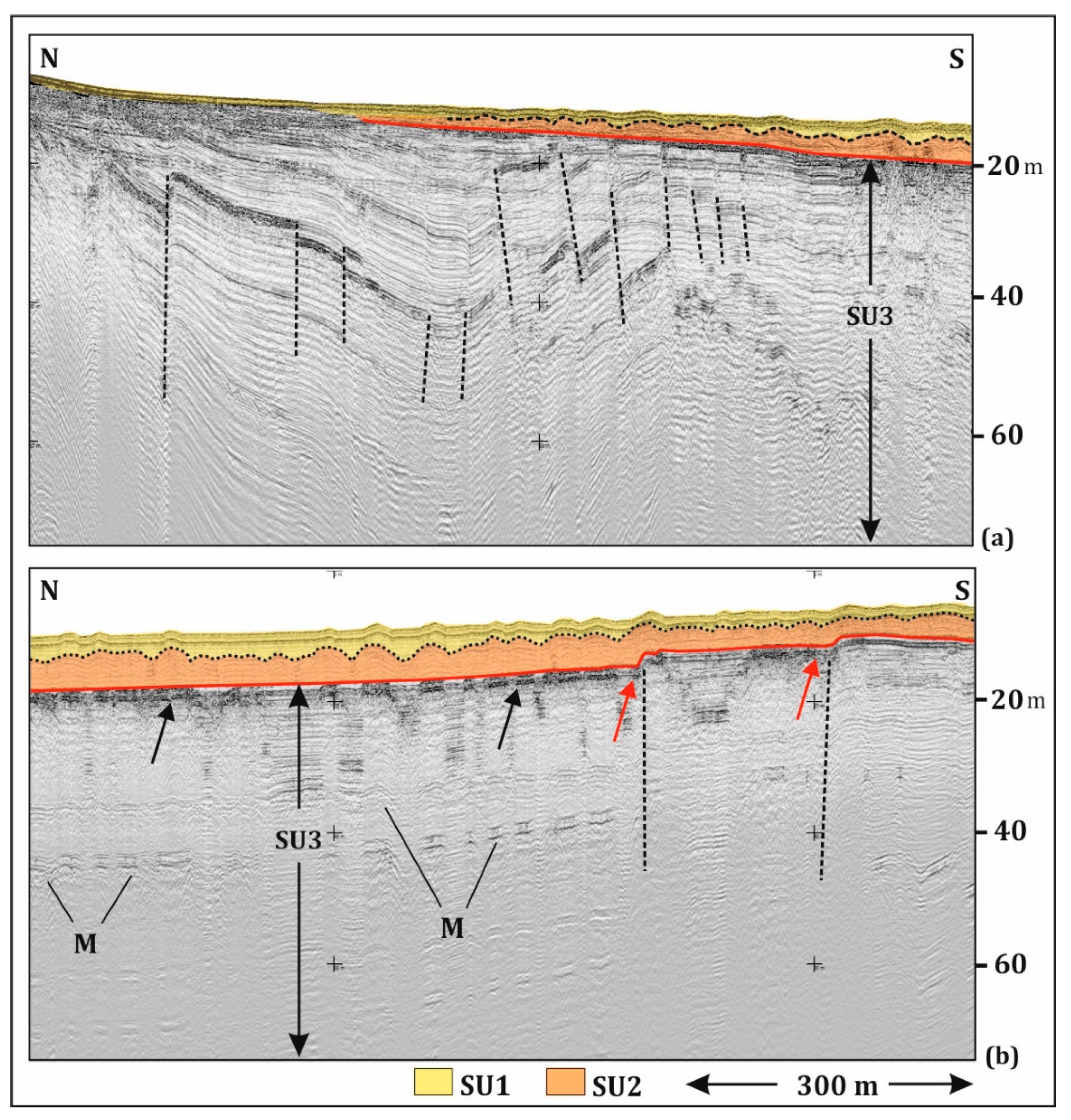
4.1. Stratigraphy
4.2. Sub-Bottom Features and Structure
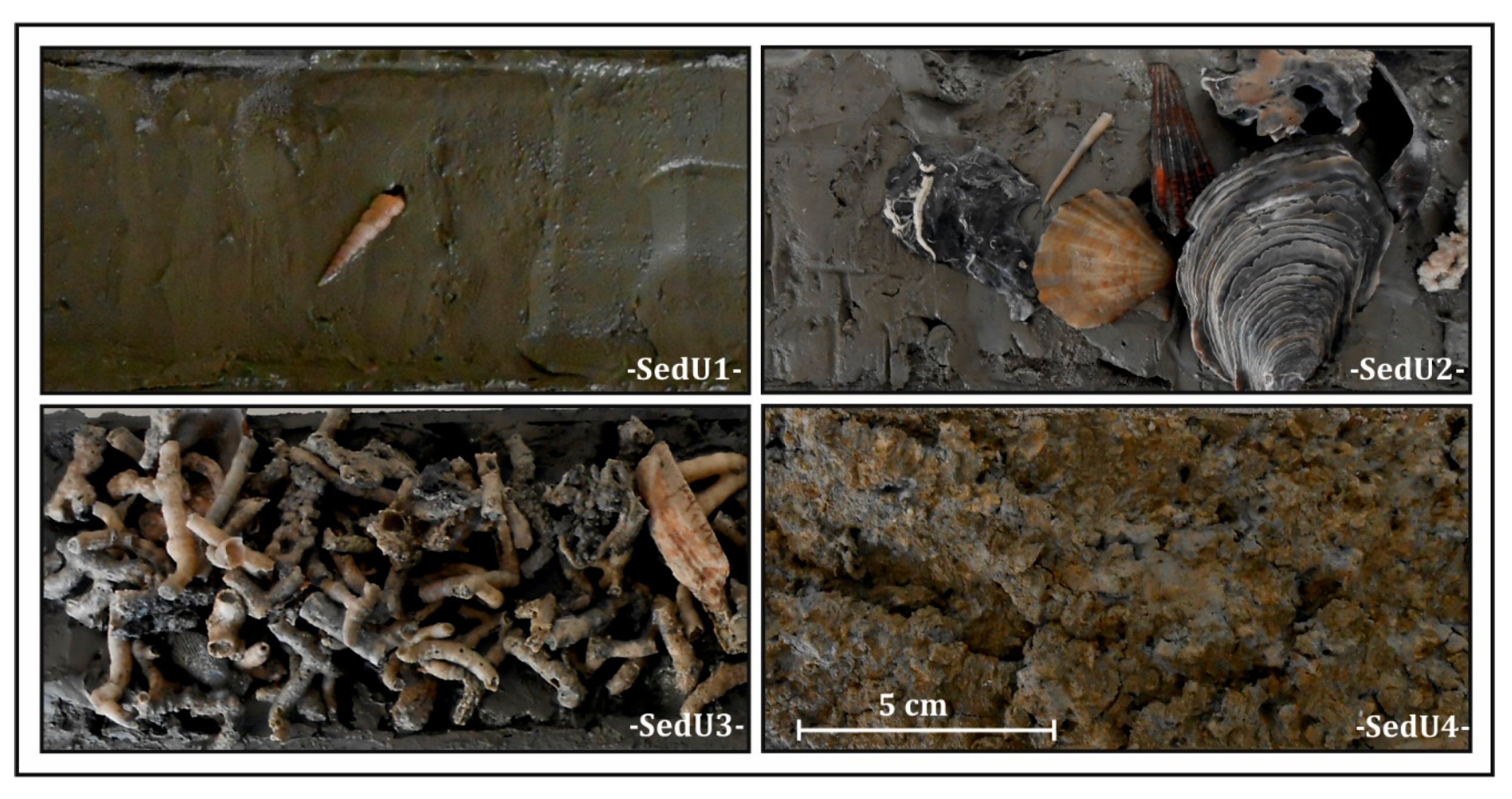
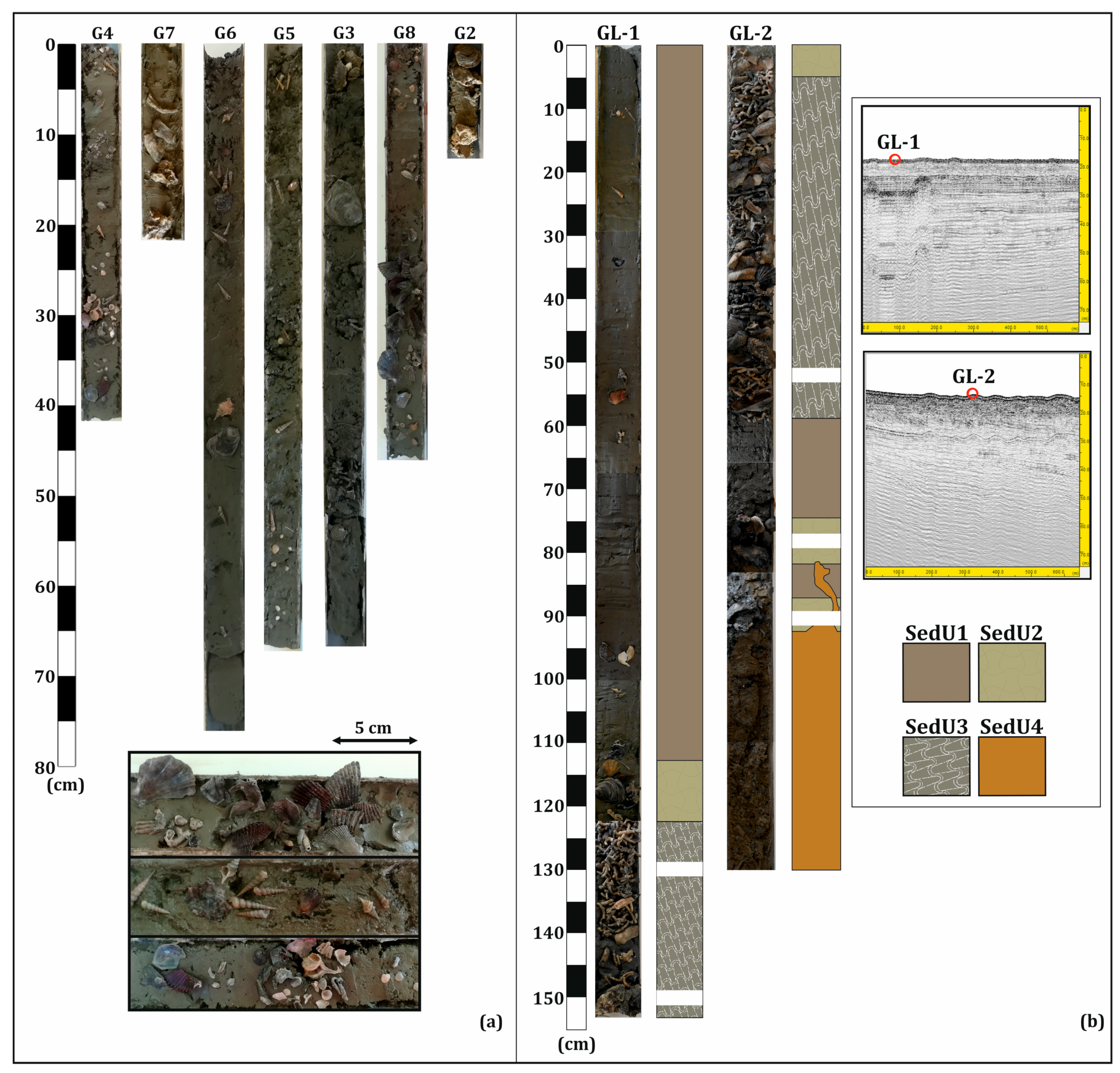
4.3. Gravity Cores
4.4. Grain Size Analysis and Radiocarbon Dating
5. Discussion
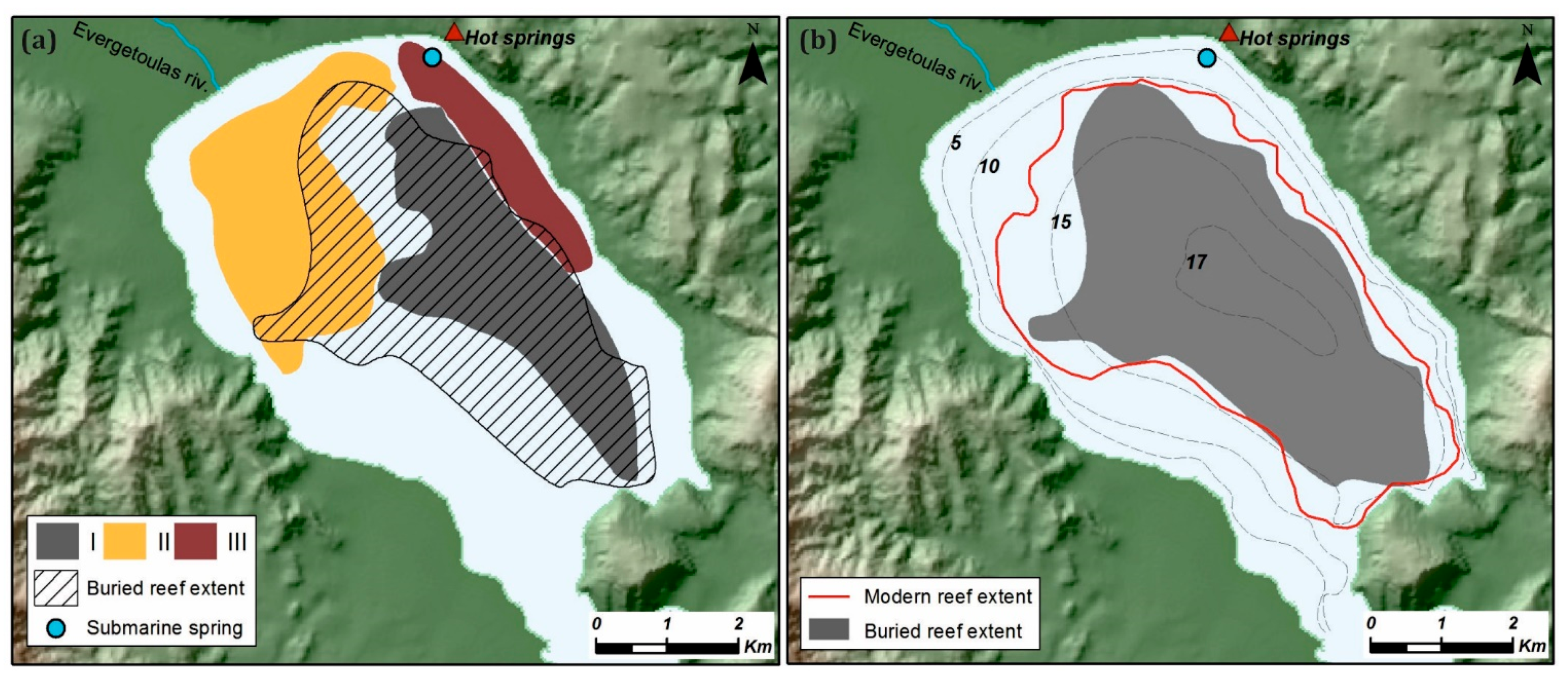
5.1. The Buried Reef Terrain
5.2. Reefs and Fluids
5.3. Reef Growth and Die-Offs
6. Conclusions
Author Contributions
Funding
Data Availability Statement
Acknowledgments
Conflicts of Interest
References
- Williams, A.N.; Ulm, S.; Sapienza, T.; Lewis, S.; Turney, C.S.M. Sea-level change and demography during the last glacial termination and early Holocene across the Australian continent. Quat. Sci. Rev. 2018, 182, 144–154. [Google Scholar] [CrossRef]
- Gordillo, S.; Bayer, M.; Boretto, G.; Charo, M. Mollusk Shells as Bio-Geo-Archives: Evaluating Environmental Changes During the Quaternary; Springer: New York, NY, USA, 2014. [Google Scholar]
- Vacchi, M.; Marriner, N.; Morhange, C.; Spada, G.; Fontana, A.; Rovere, A. Multiproxy assessment of Holocene relative sea-level changes in the western Mediterranean: Sea-level variability and improvements in the definition of the isostatic signal. Earth-Sci. Rev. 2016, 155, 172–197. [Google Scholar] [CrossRef]
- Barnett, R.L.; Bernatchez, P.; Garneau, M.; Juneau, M.N. Reconstructing late Holocene relative sea-level changes at the Magdalen Islands (Gulf of St. Lawrence, Canada) using multi-proxy analyses. J. Quat. Sci. 2017, 32, 380–395. [Google Scholar] [CrossRef]
- Gutiérrez, J.L.; Jones, C.G.; Strayer, D.L.; Iribarne, O.O. Mollusks as ecosystem engineers: The role of shell production in aquatic habitats. Oikos 2003, 101, 79–90. [Google Scholar] [CrossRef]
- Oliver, G.J.H.; Terry, J.P. Relative sea-level highstands in Thailand since the Mid-Holocene based on 14C rock oyster chronology. Palaeogeogr. Palaeoclimatol. Palaeoecol. 2019, 517, 30–38. [Google Scholar] [CrossRef]
- Bougeois, L.; De Rafélis, M.; Reichart, G.J.; de Nooijer, L.J.; Dupont-Nivet, G. Mg/Ca in fossil oyster shells as palaeotemperature proxy, an example from the Palaeogene of Central Asia. Palaeogeogr. Palaeoclimatol. Palaeoecol. 2016, 441, 611–626. [Google Scholar] [CrossRef]
- Kusnerik, K.M.; Lockwood, R.; Grant, A.N. Using the fossil record to establish a baseline and recommendations for oyster mitigation in the Mid-Atlantic US. In Marine Conservation Paleobiology; Springer: Cham, Switzerland, 2018; pp. 75–103. [Google Scholar]
- Lockwood, R.; Mann, R. A conservation palaeobiological perspective on Chesapeake Bay oysters. Philos. Trans. R. Soc. B 2019, 374, 20190209. [Google Scholar] [CrossRef] [PubMed]
- De Alteris, J.T. The role of bottom current and estuarine geomorphology on the sedimentation processes and productivity of Wreck Shoal, an oyster reef of the James River, Virginia. In Estuarine Circulation; Humana Press: Totowa, NJ, USA, 1989; pp. 279–307. [Google Scholar]
- Nielsen, S.N. Mollusk Shells as Bio-Geo-Archives. Evaluating Environmental Changes During the Quaternary. Ameghiniana 2014, 51, 155. [Google Scholar] [CrossRef]
- Song, B.; Yi, S.; Yu, S.Y.; Nahm, W.H.; Lee, J.Y.; Lim, J.; Kim, J.-C.; Yang, Z.; Han, M.; Jo, K.-N.; et al. Holocene relative sea-level changes inferred from multiple proxies on the west coast of South Korea. Palaeogeogr. Palaeoclimatol. Palaeoecol. 2018, 496, 268–281. [Google Scholar] [CrossRef]
- Cattaneo, A.; Steel, R.J. Transgressive deposits: A review of their variability. Earth-Sci. Rev. 2003, 62, 187–228. [Google Scholar] [CrossRef]
- Twichell, D.; Edmiston, L.; Andrews, B.; Stevenson, W.; Donoghue, J.; Poore, R.; Osterman, L. Geologic controls on the recent evolution of oyster reefs in Apalachicola Bay and St. George Sound, Florida. Estuar. Coast. Shelf Sci. 2010, 88, 385–394. [Google Scholar] [CrossRef]
- Carbotte, S.M.; Bell, R.E.; Ryan, W.B.F.; McHugh, C.; Slagle, A.; Nitsche, F.; Rubenstone, J. Environmental change and oyster colonization within the Hudson River estuary linked to Holocene climate. Geo-Mar. Lett. 2004, 24, 212–224. [Google Scholar] [CrossRef]
- Goff, J.A.; Lugrin, L.; Gulick, S.P.; Thirumalai, K.; Okumura, Y. Oyster reef die-offs in stratigraphic record of Corpus Christi Bay, Texas, possibly caused by drought-driven extreme salinity changes. Holocene 2016, 26, 511–519. [Google Scholar] [CrossRef]
- Manoutsoglou, E.; Hasiotis, T.; Velegrakis, A.F. Holocene records of oyster reefs in a shallow semi-enclosed island embayment of the Aegean Sea. Estuar. Coast. Shelf Sci. 2024, 302, 108–781. [Google Scholar] [CrossRef]
- Marino, G.; Rohling, E.J.; Sangiorgi, F.; Hayes, A.; Casford, J.L.; Lotter, A.F.; Kucera, M.; Brinkhuis, H. Early and middle Holocene in the Aegean Sea: Interplay between high and low latitude climate variability. Quat. Sci. Rev. 2009, 28, 3246–3262. [Google Scholar] [CrossRef]
- Triantaphyllou, M.V.; Ziveri, P.; Gogou, A.; Marino, G.; Lykousis, V.; Bouloubassi, I.; Emeis, K.-C.; Kouli, K.; Dimiza, M.; Rosell-Melé, A.; et al. Late Glacial–Holocene climate variability at the south-eastern margin of the Aegean Sea. Mar. Geol. 2009, 266, 182–197. [Google Scholar] [CrossRef]
- Giamali, C.; Koskeridou, E.; Antonarakou, A.; Ioakim, C.; Kontakiotis, G.; Karageorgis, A.P.; Roussakis, G.; Karakitsios, V. Multiproxy ecosystem response of abrupt Holocene climatic changes in the northeastern Mediterranean sedimentary archive and hydrologic regime. Quat. Res. 2019, 92, 665–685. [Google Scholar] [CrossRef]
- Seeliger, M.; Pint, A.; Frenzel, P.; Marriner, N.; Spada, G.; Vacchi, M.; Başaran, S.; Dan, A.; Seeger, F.; Seeger, K.; et al. Mid-to late-Holocene sea-level evolution of the northeastern Aegean sea. Holocene 2021, 31, 1621–1634. [Google Scholar] [CrossRef]
- Pavlides, S.; Tsapanos, T.; Zouros, N.; Sboras, S.; Koravos, G.; Chatzipetros, A. Using active fault data for assessing seismic hazard: A case study from NE Aegean Sea, Greece. In Proceedings of the Earthquake Geotechnical Engineering Satellite Conference, XVIIth International Conference on Soil Mechanics & Geotechnical Engineering, Alexandria, Egypt, 2–3 October 2009; Volume 10. [Google Scholar]
- Lambrakis, N.J.; Stamatis, G.N. Contribution to the study of thermal waters in Greece: Chemical patterns and origin of thermal water in the thermal springs of Lesvos. Hydrol. Process. 2008, 22, 171–180. [Google Scholar] [CrossRef]
- Anagnostou, C.; Sioulas, A. A sedimentological study of the gulf of Gera (Lesvos) and the possible anthropogenic influence in the geochemical cycle of the region. Bull. Geol. Soc. Greece 1989, XXIII, 193–207. [Google Scholar]
- Manoutsoglou, E.; Hasiotis, T.; Kyriakoudi, D.; Velegrakis, A.; Lowag, J. Puzzling micro-relief (mounds) of a soft-bottomed, semi-enclosed shallow marine environment. Geo-Mar. Lett. 2018, 38, 359–370. [Google Scholar] [CrossRef]
- Arhonditsis, G.; Tsirtsis, G.; Karydis, M. The effects of episodic rainfall events to the dynamics of coastal marine ecosystems: Applications to a semi-enclosed gulf in the Mediterranean Sea. J. Mar. Syst. 2002, 35, 183–205. [Google Scholar] [CrossRef]
- Zenetos, A.; Papathanassiou, E. Community parameters and multivariate analysis as a means of assessing the effects of tannery effluents on macrobenthos. Mar. Pollut. Bull. 1989, 20, 176–181. [Google Scholar] [CrossRef]
- Tsatiris, A.; Papadopoulos, V.; Makri, D.; Topouzelis, K.; Manoutsoglou, E.; Hasiotis, T.; Katsanevakis, S. Spatial distribution, abundance, and habitat use of the endemic Mediterranean fan mussel Pinna nobilis in Gera Gulf, Lesvos (Greece): Comparison of design-based and model-based approaches. Mediterr. Mar. Sci. 2018, 19, 642–655. [Google Scholar] [CrossRef]
- Lioupa, V.; Karsiotis, P.; Arosio, R.; Hasiotis, T.; Wheeler, A.J. A Comparative Crash-Test of Manual and Semi-Automated Methods for Detecting Complex Submarine Morphologies. Remote Sens. 2024, 16, 4093. [Google Scholar] [CrossRef]
- Manoutsoglou, E.; Hasiotis, T.; Andreadis, O.; Velegrakis, A. Seismic evidence of fluids in the sediments of the semi-enclosed Gulf of Gera (Lesvos, Greece). In Proceedings of the Hydromedit 2021 (4th International Congress on Applied Ichthyology, Oceanography & Aquatic Environment), Mytilene, Greece, 4–6 November 2021; pp. 249–253. [Google Scholar]
- Folk, R.L. Petrology of the Sedimentary Rocks, 2nd ed.; Hemphill Publishing Company: Austin, TX, USA, 1980. [Google Scholar]
- Blott, S.J.; Pye, K. GRADISTAT: A grain size distribution and statistics package for the analysis of unconsolidated sediments. Earth Surf. Process. Landf. 2001, 26, 1237–1248. [Google Scholar] [CrossRef]
- Maniatis, Y.; Oberlin, C.; Tsirtsoni, Z. “BALKANS 4000”: The Radiocarbon dates from archaeological contexts. In The Human Face of Radiocarbon; TMO 69; Tsirtsoni, Z., Ed.; Maison de l’Orient et de Mediterranne: Lyon, France, 2016; pp. 41–65. [Google Scholar]
- Bronk-Ramsey, C. OxCal Version 4.4.2; 2020. Available online: https://c14.arch.ox.ac.uk (accessed on 1 April 2022).
- Reimer, P.; Austin, W.; Bard, E.; Bayliss, A.; Blackwell, P.G.; Ramsey, C.B.; Butzin, M.; Cheng, H.; Edwards, R.L.; Friedrich, M.; et al. The IntCal20 Northern Hemisphere radiocarbon age calibration curve (0–55 cal kBP). Radiocarbon 2020, 62, 725–757. [Google Scholar] [CrossRef]
- Facorellis, Y.; Maniatis, Y.; Kromer, B. Apparent 14C ages of marine mollusk shells from a Greek island: Calculation of the marine reservoir effect in the Aegean Sea. Radiocarbon 1997, 40, 963–973. [Google Scholar] [CrossRef]
- Manoutsoglou, E. A Study of Biogenic Reefs in Semi-Enclosed Embayments: The Cases of Gera and Kalloni Gulf in Lesvos Island. Ph.D. Thesis, University of the Aegean, Mitilini, Greece, 2022; p. 164. [Google Scholar]
- Judd, A.; Hovland, M. Seabed Fluid Flow: The Impact on Geology, Biology and the Marine Environment; Cambridge University Press: Cambridge, UK, 2007. [Google Scholar]
- Toth, Z.; Spiev, V.; Jensen, J. Seismo-acoustic signatures of shallow free gas in the Bornholm Basin, Baltic Sea. Cont. Shelf Res. 2014, 88, 228–239. [Google Scholar] [CrossRef]
- Jasniewicz, D.; Klusek, Z.; Brodecka-Goluch, A.; Bolalek, J. Acoustic investigations of shallow gas in the southern Baltic Sea (Polish Exclusive Economic Zone): A review. Geo-Mar. Lett. 2019, 39, 1–17. [Google Scholar] [CrossRef]
- Kontis, E.E.; Gaganis, P. Hydrochemical characteristics and groundwater quality in the Island of Lesvos, Greece. J. Glob. Nest 2012, 14, 422–430. [Google Scholar]
- Hovland, M. Deep-Water Coral Reefs: Unique Biodiversity Hotspots; Praxis (Springer): Zürich, Switzerland, 2008; ISBN 1402084617. [Google Scholar]
- Petersen, J.M.; Dubilier, N. Methanotrophic symbioses in marine invertebrates. Environ. Microbiol. Rep. 2009, 1, 319–335. [Google Scholar] [CrossRef]
- Karnaukh, V.N.; Astakhov, A.S.; Vereshchagina, O.F.; Tsoy, I.B.; Kosmach, D.A.; Sagalaev, S.G.; Volkova, T.I.; Dubina, V.A.; Prushkovskaya, I.A. Formation of subsurface shallow gas accumulations in Amurskiy Bay (Peter the Great Bay, Sea of Japan) as a result of postglacial sea-level change, paleoceanographic conditions and hydrological activity. Mar. Geol. 2016, 372, 31–52. [Google Scholar] [CrossRef]
- Cukur, D.; Krastel, S.; Çağatay, M.N.; Damcı, E.; Meydan, A.F.; Kim, S.P. Evidence of extensive carbonate mounds and sublacustrine channels in shallow waters of Lake Van, eastern Turkey, based on high-resolution chirp subbottom profiler and multibeam echosounder data. Geo-Mar. Lett. 2015, 35, 329–340. [Google Scholar] [CrossRef]
- Papatheodorou, G.; Hasiotis, T.; Ferentinos, G. Gas-charged sediments in the Aegean and Ionian Seas, Greece. Mar. Geol. 1993, 112, 171–184. [Google Scholar] [CrossRef]
- Christodoulou, D.; Papatheodorou, G.; Ferentinos, G.; Masson, M. Active seepage in two contrasting pockmark fields in the Patras and Corinth gulfs, Greece. Geo-Mar. Lett. 2003, 23, 194–199. [Google Scholar] [CrossRef]
- Kordella, S.; Christodoulou, D.; Fakiris, E.; Geraga, M.; Kokkalas, S.; Marinaro, G.; Iatrou, M.; Ferentinos, G.; Papatheodorou, G. Gas Seepage-Induced Features in the Hypoxic/Anoxic, Shallow, Marine Environment of Amfilochia Bay, Amvrakikos Gulf (Western Greece). Geosciences 2021, 11, 27. [Google Scholar] [CrossRef]
- Christodoulou, D.; Papatheodorou, G.; Geraga, M.; Etiope, G.; Giannopoulos, N.; Kokkalas, S.; Dimas, X.; Fakiris, E.; Sergiou, S.; Georgiou, N.; et al. Geophysical and Geochemical Exploration of the Pockmark Field in the Gulf of Patras: New Insights on Formation, Growth and Activity. Appl. Sci. 2023, 13, 10449. [Google Scholar] [CrossRef]
- Carroll, J.M.; Dashiell, R.; Watts, J.C.; Hunter, E.A. Tidal level affects the prevalence and impacts of pests and parasites on oysters (Crassostrea virginica) on intertidal reefs in Georgia, USA. Mar. Biol. 2021, 168, 45. [Google Scholar] [CrossRef]
- Spalt, N.; Murgulet, D.; Abdulla, H. Spatial variation and availability of nutrients at an oyster reef in relation to submarine groundwater discharge. Sci. Total Environ. 2020, 710, 136283. [Google Scholar] [CrossRef]
- O’Brien, S.R.; Mayewski, P.A.; Meeker, L.D.; Meese, D.A.; Twickler, M.S.; Whitlow, S.I. Complexity of Holocene climate as reconstructed from a Greenland ice core. Science 1995, 270, 1962–1964. [Google Scholar] [CrossRef]
- Aksu, A.E.; Yaşar, D.; Mudie, P.J.; Gillespie, H. Late glacial-Holocene paleoclimatic and paleoceanographic evolution of the Aegean Sea: Micropaleontological and stable isotopic evidence. Mar. Micropaleontol. 1995, 25, 1–28. [Google Scholar] [CrossRef]
- Weninger, B.; Alram-Stern, E.; Bauer, E.; Clare, L.; Danzeglocke, U.; Jöris, O.; Kubatzki, C.; Rollefson, G.; Todorova, H.; van Andel, T. Climate forcing due to the 8200 cal yr BP event observed at Early Neolithic sites in the eastern Mediterranean. Quat. Res. 2006, 66, 401–420. [Google Scholar] [CrossRef]
- Gogou, A.; Bouloubassi, I.; Lykousis, V.; Arnaboldi, M.; Gaitani, P.; Meyers, P.A. Organic geochemical evidence of Late Glacial–Holocene climate instability in the North Aegean Sea. Palaeogeogr. Palaeoclimatol. Palaeoecol. 2007, 256, 1–20. [Google Scholar] [CrossRef]
- Poulos, S.; Kapsimalis, V.; Tziavos, C.; Pavlakis, P.; Leivaditis, G.; Collins, M. Sea-level stands and Holocene geomorphological evolution of the northern deltaic margin of Amvrakikos Gulf (western Greece). Z. Geomorphol. 2005, 137, 125–145. [Google Scholar]
- Katsouras, G.; Gogou, A.; Bouloubassi, I.; Emeis, K.C.; Triantaphyllou, M.; Roussakis, G.; Lykousis, V. Organic carbon distribution and isotopic composition in three records from the eastern Mediterranean Sea during the Holocene. Org. Geochem. 2010, 41, 935–939. [Google Scholar] [CrossRef]
- Triantaphyllou, M.V.; Gogou, A.; Bouloubassi, I.; Dimiza, M.; Kouli, K.; Rousakis, G.; Kotthoff, U.; Emeis, K.C.; Papanikolaou, M.; Athanasiou, M.; et al. Evidence for a warm and humid Mid-Holocene episode in the Aegean and northern Levantine Seas (Greece, NE Mediterranean). Reg. Environ. Change 2014, 14, 1697–1712. [Google Scholar] [CrossRef]
- Bini, M.; Zanchetta, G.; Perşoiu, A.; Cartier, R.; Català, A.; Cacho, I.; Dean, J.R.; Di Rita, F.; Drysdale, R.N.; Finne, M.; et al. The 4.2 ka BP Event in the Mediterranean region: An overview. Clim. Past 2019, 15, 555–577. [Google Scholar] [CrossRef]
- Ryan, E.J.; Morgan, K.M.; Kench, P.S.; Owen, S.D.; Carvajal, C.P.; Turner, T. Fossil reefs reveal temporally distinct late Holocene lagoonal reef shutdown episodes at Kiritimati Island, central Pacific. Geophys. Res. Lett. 2021, 48, e2020GL092113. [Google Scholar] [CrossRef]
- Jing, F.; Fu, W.; Liping, Z.; Shuo, Y.; Tianjiao, W.; Yufei, L.; Yang, L. Study on the buried oyster reefs and environmental changes with the underlying muddy sediments on the Northwest Coast of Bohai Bay. IOP Conf. Ser. Mater. Sci. Eng. 2020, 780, 042059. [Google Scholar] [CrossRef]
- Dickson, S.; Carlin, J.; Bonuso, N.; Kirby, M.E. Documenting the Evolution of a Southern California Coastal Lagoon during the Late Holocene. Coasts 2022, 2, 102–124. [Google Scholar] [CrossRef]
- Peyron, O.; Combourieu-Nebout, N.; Brayshaw, D.; Goring, S.; Andrieu-Ponel, V.; Desprat, S.; Magny, M. Precipitation changes in the Mediterranean basin during the Holocene from terrestrial and marine pollen records: A model–data comparison. Clim. Past 2017, 13, 249–265. [Google Scholar] [CrossRef]
- Woods, H.; Hargis, W.J.; Hershner, C.H.; Mason, P. Disappearance of the natural emergent 3-dimensional oyster reef system of the James River, Virginia, 1871–1948. J. Shellfish Res. 2005, 24, 139–142. [Google Scholar]
- Seeliger, M.; Pint, A.; Frenzel, P.; Feuser, S.; Pirson, F.; Riedesel, S.; Brückner, H. Foraminifera as markers of Holocene sea-level fluctuations and water depths of ancient harbours—A case study from the Bay of Elaia (W Turkey). Palaeogeogr. Palaeoclimatol. Palaeoecol. 2017, 482, 17–29. [Google Scholar] [CrossRef]


| Lab Code | Core Sample | Depth (cm) | Species | Uncorrected 14C (yr BP) | Calibrated (yr BP) |
|---|---|---|---|---|---|
| DEM-2739 | GL1-A | 130 | C. caespitosa | 3834 ± 30 | 3790–3450 |
| DEM-2735 | GL1-B | 150 | O. edulis | 5548 ± 30 | 5889–5587 |
| DEM-2740 | GL2-A | 52 | C. caespitosa | 6345 ± 30 | 6754–6424 |
| DEM-2737 | GL2-B | 79 | O. edulis | 6898 ± 40 | 7382–7043 |
| DEM-2736 | GL2-C | 90 | O. edulis | 7145 ± 30 | 7572–7310 |
Disclaimer/Publisher’s Note: The statements, opinions and data contained in all publications are solely those of the individual author(s) and contributor(s) and not of MDPI and/or the editor(s). MDPI and/or the editor(s) disclaim responsibility for any injury to people or property resulting from any ideas, methods, instructions or products referred to in the content. |
© 2025 by the authors. Licensee MDPI, Basel, Switzerland. This article is an open access article distributed under the terms and conditions of the Creative Commons Attribution (CC BY) license (https://creativecommons.org/licenses/by/4.0/).
Share and Cite
Manoutsoglou, E.; Hasiotis, T. Evidence of Holocene Sea-Level Rise from Buried Oyster Reef Terrain in a Land-Locked Insular Embayment in Greece. Geosciences 2025, 15, 105. https://doi.org/10.3390/geosciences15030105
Manoutsoglou E, Hasiotis T. Evidence of Holocene Sea-Level Rise from Buried Oyster Reef Terrain in a Land-Locked Insular Embayment in Greece. Geosciences. 2025; 15(3):105. https://doi.org/10.3390/geosciences15030105
Chicago/Turabian StyleManoutsoglou, Evangelia, and Thomas Hasiotis. 2025. "Evidence of Holocene Sea-Level Rise from Buried Oyster Reef Terrain in a Land-Locked Insular Embayment in Greece" Geosciences 15, no. 3: 105. https://doi.org/10.3390/geosciences15030105
APA StyleManoutsoglou, E., & Hasiotis, T. (2025). Evidence of Holocene Sea-Level Rise from Buried Oyster Reef Terrain in a Land-Locked Insular Embayment in Greece. Geosciences, 15(3), 105. https://doi.org/10.3390/geosciences15030105