

Geosciences, Volume 15, Issue 3 (March 2025) – 38 articles
Cover Story (view full-size image):
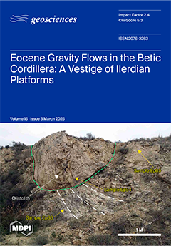
In the Betic-Rif Cordilleras, contrary to other sectors of the western Tethys, the Eocene platforms started in the Cuisian after a gap including the Ilerdian. An Eocene succession with gravity flows consisting of turbidites and olistostromes was detected in the Aspe-Terreros Prebetic section (External Betic Zone). In one of the turbidites, we dated the middle Ilerdian, on the basis of LBF, representing a vestige of a missing Illerdian carbonate platform. The microfacies of these deposits rich in LBF have been described and documented. The gap in the sedimentation and absence of Ilerdian platforms in the Betic-Rif have been related to the so-called Eo-Alpine tectonics (Cretaceous to Paleogene) and sea-level variations contemporarily with the establishment of shallow marine realms in the western Tethys. View this paper
- Issues are regarded as officially published after their release is announced to the table of contents alert mailing list.
- You may sign up for e-mail alerts to receive table of contents of newly released issues.
- PDF is the official format for papers published in both, html and pdf forms. To view the papers in pdf format, click on the "PDF Full-text" link, and use the free Adobe Reader to open them.
Previous Issue
Next Issue